INSAT-3D PRODUCTS FOR THE MONSOON MONITORING and APPLICATIONS
|
|
|
- Lesley Cross
- 5 years ago
- Views:
Transcription
1 INSAT-3D PRODUCTS FOR THE MONSOON MONITORING and APPLICATIONS Ashim Kumar Mitra February 2016 National Satellite Meteorological Center, India Meteorological Department, New Delhi

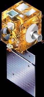


2 Current Indian Geostationary Meteorological Satellites 74 o 83 o 93.5 o Kalpana-1 INSAT-3D:2013 INSAT-3A
3 INSAT - 3D Improved Understanding of Mesoscale Systems 6 Channel IMAGER 19 Channel SOUNDER Spectral Bands (µm) Visible : Short Wave Infra Red : Mid Wave Infra Red : Water Vapour : Thermal Infra Red 1 : Thermal Infra Red 2 : Resolution : 1 km for Vis, SWIR 4 km for MIR, TIR 8 km for WV Spectral Bands (µm) Short Wave Infra Red : Six bands Mid Wave Infra Red : Five Bands Long Wave Infra Red : Seven Bands Visible : One Band Resolution (km) : 10 X 10 for all bands No of simultaneous : Four sounding per band
4 No. Parameters Input Channels No. Parameters Input Channels Geophysical Parameters to be derived from INSAT -3D (imager) 1. Outgoing Long wave Radiation (OLR) TIR -1, TIR -2, WV 10. Water Vapor Wind (WVW) WV, TIR -1, TIR Quantitative Precipitation Estimation ( QPE),IMSRA,HE TIR -1, TIR -2, WV,Model FG. 11. Upper Tropospheric Humidity (UTH) WV, TIR -1, TIR Sea Surface Temperature (SST) SWIR,TIR -1, TIR -2, MIR 4. Snow Cover VIS, SWIR, TIR -1, TIR Snow Depth VIS, SWIR, TIR -1, TIR Temperature, Humidity profile & Total ozone 13. Value added parameters from sounder products Sounder all channels Sounder products 14. FOG SWIR, MIR, TIR - 1, TIR Fire MIR, TIR Normalized Difference Vegetation Index 7. Smoke VIS, TIR -1, TIR -2, MIR 8. Aerosol VIS, TIR -1, TIR Cloud Motion Vector (CMV) VIS, TIR -1, TIR Flash Flood Analyzer CCD 17. HSCAS VIS TIR -1, TIR -2, VIS 18. Tropical Cyclone- AODT technique,tir-
5 INSAT-3D Imager Products types and formats S.No. Data Product Processing Level Code Format Remarks Standard Products 1 Standard Product Full Disk L1B STD HDF Per Pixel Lat & Lon as viewed by Satellite 2 Standard Product Full Disk Fixed Grid L1C STD HDF Projected on Fixed Grid 3 Standard Sector Product L1C Sector mnemonic HDF Map Projected Geo-Physical Parameters 1 Outgoing long wave radiations L2B OLR HDF Per Pixel 2 Rainfall using Hydro Estimator L2B HEM HDF Per Pixel 3 FOG L2C FOG HDF Per Pixel 4 SNOW L2C SNW HDF Per Pixel 5 Cloud Mask L2B CMK HDF Per Pixel 6 Upper Troposphere Humidity L2B UTH HDF PerPixel 7 Sea Surface Temperature L2B SST HDF PerPixel Geo-Physical Parameters 1 FIRE L2P FIR KML Point 2 SMOKE L2P SMK KML Point 3 Atmospheric Motion Vectors L2P AMV HDF VIS, TIR, WV, MIR (Point) Geo-Physical Parameters 1 INSAT Multi-Spectral Rainfall Algorithm (IMSRA) L2G IMR HDF 0.1 deg x 0.1 deg 2 Quantitative Precipitation Estimation L2G QPE HDF 1 deg x 1 deg 3 Aerosol Optical Depth L2G AOD HDF 0.1 deg x 0.1 deg S.No. Data Product Processing Level Code Format Remarks Standard Products Binned Geo-Physical Parameters (Temporally Binned) 1 Outgoing long wave radiations L3B OLR HDF Daily, Weekly, Monthly and Yearly Per Pixel 2 Rainfall using Hydro Estimator L3B HEM HDF Daily, Weekly, Monthly and Yearly (Per Pixel) 3 Sea Surface Temperature L3G SST HDF Daily, Weekly, Monthly and Yearly 0.5 deg X 0.5 deg 4 Upper Troposphere Humidity L3G UTH HDF Daily, Weekly, Monthly and Yearly,0.1 deg x 0.1 deg
6 Overview INSAT-3D satellite data are used to analyze the characteristics of monsoon circulation features over India region during southwest monsoon, 2015 with the help of its imageries and derived products. The study can be taken as a better utilization of satellite observations for monitoring and prediction of monsoon circulation and precipitation over India. The rainfall estimations (HEM,IMR and QPE) have also observed and validated with the actual observations during June-September 2015.


7 Circulation features during onset and advance phase of southwest Monsoon, 2015 Advance of monsoon over Andaman Sea This year, the southwest monsoon set over the south Andaman Sea on 16 th May, four days earlier than the normal date. Low level cross equatorial monsoon flow has started appearing over adjoining south Bay of Bengal. During the last few days, considerable increase in the rainfall activity over the Bay of Bengal has also been observed
 imageries that just before the onset of monsoon over Kerala, deep convective cloud area starts increasing over southeast Arabian Sea and neighboring")
.")
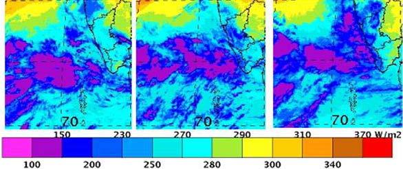
8 Onset of monsoon over Kerala The actual onset of monsoon over Kerala on 5 th June 2015, 4 days later than its normal date of 1 st June. It can be seen from the INSAT-3D Infra-red (IR) imageries that just before the onset of monsoon over Kerala, deep convective cloud area starts increasing over southeast Arabian Sea and neighboring areas. Sequence of imageries of IR shows the rapid northward movement of the clouds from 3 rd to5 th June 2015 i.e., the time of monsoon onset Fig. (a, b, c).the moisture influx can also be seen from the water vapor imagery on the same day Fig. (d). Associated with this event, monsoon advanced into entire south Arabian Sea, some parts of central Arabian Sea, entire Lakshadweep area, some parts of coastal & south interior Karnataka and Tamil Nadu, most parts of south Bay of Bengal, some more parts of west central Bay of Bengal and some parts of northeast Bay of Bengal.

 flux, thermally emitted from earth atmosphere system, is estimated by applying regression equation relating OLR flux with geostationary")
9 Outgoing Longwave Radiation (OLR) For Monitoring of Monsoon Features The outgoing long wave radiation has been used traditionally for radiation budget studies of the Earth atmospheric system. This is mainly due to the fact that in the tropics, the OLR is largely modulated by cloudiness. In particular it varies with the cloud top temperature, and consequently, low values of OLR indicate major convective system. In general at IMDPS, total outgoing long wave radiation (OLR) flux, thermally emitted from earth atmosphere system, is estimated by applying regression equation relating OLR flux with geostationary Indian National Satellite (INSAT-3D) VHRR observed WV (5.7to 7.1μm) and infrared window radiances (10.5 to 12.5 μm). On 5th of June 2015, Fig. shows the OLR values were around 190 W/m2 over the south Arabian Sea. These values are confined to the box for consecutive last 2 days and can be seen on Fig
 (low pressure areas and stronger systems) were formed.")
 & Kemon (26 July 2 Aug.")
 and one over Arabian Sea (22 24 June). These two enhancements are named as i) BD Curve Enhancement and ii) NHC Curve Enhancement.")
10 Chief Synoptic Features during Monsoon Season as Observed Through Satellite Imageries During the southwest monsoon season, 11 low pressure systems (LPS) (low pressure areas and stronger systems) were formed. Out of these, 8 further intensified (Depression, deep depression, cyclonic storms) against a normal of 4-6 Depressions during the season. Two of which intensified into cyclonic storm Ashobaa (7 12 June) & Kemon (26 July 2 Aug.), over Arabian Sea and Bay of Bengal respectively and the 3 as Deep Depressions with 2 over land (27-30 July & Sept.) and one over Arabian Sea (22 24 June). These two enhancements are named as i) BD Curve Enhancement and ii) NHC Curve Enhancement. For detailed methodology of these curves see misc/other/faq/faq_enhanc e.html.

11 Analysis of Monsoon rainfall using INSAT-3D HE and IMR method In July, majority of the subdivisions from Peninsular India and that from north India along the Himalayas received deficient or scanty rainfall. In total, 19 subdivisions received deficient rainfall, 4 subdivisions received scanty rainfall and 6 subdivisions received normal rainfall. Fig. shows the rainfall distribution of monthly Hydro Estimator(HE) and INSAT Multi-spectral rainfall (IMR) product for the month of July and August 2015 across the North, northwest to southern peninsular India. The product clearly depicts the less rainfall in Peninsular India as compared to north and northwest region in the month of July whereas In August, majority of the subdivisions from northwest India, central India and neighboring Peninsula received deficient/ scanty rainfall. On the other hand, majority of the subdivisions from northeast India received normal/ excess rainfall. NW India NW India, Central India & Peninsular Subdivisions from Peninsular India NE India July 2015 (IMR) August 2015 (IMR)

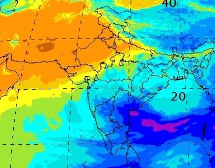
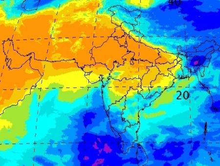
12 Withdrawal of Southwest Monsoon The monsoon withdrawal normally starts from the country around 1st September and continues till about 15 October, when it completely withdraws from the country. As per IMD, withdrawal over the country may be declared keeping the spatial continuity, reduction in moisture as usually depicted in the water vapor imageries and prevalence of dry weather for 5 days. From satellite imageries this can be observed by the water vapor imageries as it provides a measure of moisture content of the atmosphere at middle levels and helps in deciding the withdrawal of monsoon. It is mainly used to assess the monsoon withdrawal pattern along with the visible and IR imageries and derived products such OLR values. A change over in the lower tropospheric circulation pattern over the region from cyclonic to anti cyclonic resulted in the withdrawal of southwest monsoon from the northwestern parts of Rajasthan on 4th September depicted in INSAT-3D water vapor imagery Fig. (a). On 29th September,Fig. (b), monsoon withdrew from remaining parts of Rajasthan, Punjab, Haryana, Chandigarh & Delhi. On 6th October, the monsoon further withdrew from some more parts of Bihar; remaining parts of Madhya Pradesh; some parts of Jharkhand, Chhattisgarh.

13 Onset and Withdrawal from INSAT OLR Onset Withdrawal
14 Rainfall Estimations from INSAT-3D There are three main objectives under the rainfall retrieval algorithms from INSAT-3D. These techniques are popularly known as GOES Precipitation Index (GPI) and INSAT Multispectral Rainfall Algorithm Technique (IMSRA) and Hydro- Estimator. All the algorithms are state-of-the-art and aimed at estimation of rainfall with different applications at different spatial and temporal requirements respectively. Here two of these techniques (GPI and IMSRA) would be modified for their applicability in the context of Indian subcontinent and adjoining oceans.
15 INSAT-3D Rainfall using Modified GPI Method This algorithm focuses on precipitation estimation using GPI technique with the implementation of the environmental moisture factor with relatively high spatial and temporal resolution. The steps of the algorithm are as below: To generate one a total day rainfall maps using 3 hourly brightness temperatures of IR(11 um) images for 1.0 x 1.0 deg latitude /longitude boxes using Arkin s GPI method. To generate mean and spatial variance of temperatures at 1.0 x 1.0 deg latitude/longitude and finally a total day rainfall accumulation. To derive QPE based on daily basis following the 3 hourly data of IR observations (8 images a day). The final objective (proposed) is to augment the GPI rainfall estimates possibly in better than the above resolutions based on environmental moisture correction factor applied to GPI, named as MGPI.
16 The fractional area covered by clouds colder than a chosen threshold temperature (235 K) in a given area is correlated with the areal average precipitation over that area. Fractional Cloud Cover within a box can be estimated as No. of Pixels colder than 235 K Total No. of pixels
17 QPE is computed by the formula QPE = K x Fc x N where K is a regression coefficient ( 71.2 mm/day) Fc is fractional cloud cover and N is the number of days
18 The area of computation of QPE is N40 - S40 and E40 - E120 On regular basis, QPE is computed for every 3 hourly images over a grid box of 1 x 1 lat./long. Daily, weekly and monthly QPE also computed.


19 Weekly Monthly Yearly Daily
20 IMSRA The main objectives here in IMSRA algorithm are to estimate rainfall by developing a Multispectral Rainfall Algorithm which is an optimal combination of GMSRA and some of the innovative proposed approaches that utilizes microwave remote sensing measurements from polar orbiting satellites. Here, the rainfall algorithm is with more advantageous that combines satellite water vapor channel data to account for limitations. Rainfall estimates are produced at the high spatial resolution and temporal frequency of the IR/WV data using rainfall information from the PMW data.
21 The technique has the following components: 1. Identify areas for very deep convective cores from IR and WV channels ( 11mm-6mm.), which corresponds well with rainfall. 2. To screen mid-to upper level clouds with or without thin cirrus above the rain and non-rain baring clouds. 3. Cloud growth classification based on temporal gradients of TIR TB s. 4. Filtering of low and non raining clouds along with the warm and semi-transperent clouds based on IR and WV when rainfall is estimated for clouds having brightness temperatures colder than 240K. 5. Spatial and temporal co-location of INSAT-TIR brightness temperature, and TRMM / SSM/I rainfall for creation of matched database. 6. To compute instantaneous rain rate using pre-calibrated rain rate for cloud top brightness temperature ( 11 mm) for each pixel classified as containing raining clouds along with Satellite Microwave Radiometric measurements (e.g TRMM Microwave Imager-TMI). 7. To adjust the rainfall estimates in association with the product of Integrated.Precipitable water and Relative Humidity from 500 mb Surface (from Eta/IMD model). On the synoptic scale, the 6.7 mm water vapor is especially useful for detecting jet streaks, vorticity centers and other features that are associated with upward vertical motion and lift the moist, unstable air resulting in the production of clouds and precipitation.


22 Half Hourly Monthly Weekly
23 RAINFALL ESTIMATION H-E Method The HE algorithm uses infrared (IR) brightness temperatures to identify regions of rainfall and retrieve rainfall rate, while using National Centers for Environmental Prediction (NCEP) Global Forecast System (GFS) model fields to account for the effects of moisture availability, evaporation, orographic modulation, and thermodynamic profile effects. Method utilizes the precipitable water (PW) and water vapour (WV) correction to make modifications for dry/wet environment and saturation level adjustments for rain that comes from the warm clouds. This method was very successful for precipitation measurement but was highly subjective and depends on seasonal characteristics of rainfall amount.
24 Hydro-Estimator is most recent of the attempts by NESDIS to improve and make IFFA automated. Hydro-Estimator method for precipitation measurement over Indian region encompassing area between longitudes 30 E -to130 E and latitudes 50 N -50 S.

25 Daily Weekly Monthly
 Surface Observations Temporal Resolution Daily Half Hourly, Daily Half Hourly, Daily 3")


26 INSAT-3D HEM INSAT-3D IMR IMD-NCMRWF (Daily Merged) Rain Estimation INSAT-3D HEM INSAT-3D IMR INSAT-3D QPE IMERG Data (GPM) Surface Observations Temporal Resolution Daily Half Hourly, Daily Half Hourly, Daily 3 Hourly, Daily Half Hourly Daily Spatial Resolution 0.5 * X X0.1 1 * 1 0.1X0.1 Rainguages+AWS and ARG Observatories The data from IMD-NCMRWF Rain estimation, INSAT-3D HE Method, INSAT-3D IMR method, INSAT-3D QPE method and Surface Observations have been considered on the daily basis for validation. The data from INSAT-3D HE method, INSAT-3D IMR method and IMERG data has been considered for validation on the half hourly basis.
27 Data Availability QPE(GPI) HDF Half Hourly,Daily, Monthly, Sesonal 1X1 Deg. IMSRA HDF Half Hourly, Daily, Monthly, Sesonal 0.1X0.1 Deg, HEM HDF Half Hourly, Daily, Monthly, Sesonal Per Pixel (around 0.1 X0.1 Deg) Daily data is computed from 03 UTC to 03UTC

28 SATMET page
29 Validation INSAT-3D satellite derived rainfall estimations i.e., Hydro-Estimator Method (HEM) INSAT Multi-spectral rainfall (IMR) and Quantitative Precipitation Estimation (QPE) for the analysis of heavy rainfall episodes over the Indian region from operational INSAT Meteorological Data Processing System (IMDPS), New Delhi for the southwest monsoon season (June to September,2015) The data set used for the comparison and validations are, Integrated Multi-satellitE Retrievals for GPM (IMERG) (0.1 x 0.1 degree) data, Huffman, G. J., and others IMD`s surface rainguage data and Daily merged satellite gauge rainfall data (0.5 x 0.5 degree) (Ashish Mitra et al, 2009) at locations approximately 12-km apart. Overall 40 cases of heavy rainfall over the Indian region have been analysed.
30 2D Histogram of INSAT-3D Derived Heavy R/F data against surface observations (raingauge) The records are located near the line of perfect agreement for HEM as compared to IMR and QPE, which is around 70%, 30% and 1 to 2% respectively with the accuracy of ±20mm. This indicates that when the HEM does estimate heavy rain, it agrees well with surface observations in general.
 shows that HEM")

31 Overall Daily Performance for the Monsoon Season 2015(surface observations) The performance statistics with surface observation with over all data set (no rain, light rain, moderate/heavy/very heavy) shows that HEM correlate well with the data set, but deviations are also quite high. HEM tends to overestimate light rain but underestimates moderate to high rain over the land whereas IMR and QPE have better skills for light to moderate rainfall.
 shows that QPE correlate well with the")

32 Overall Performance for the Monsoon Season 2015(GPM data) The performance statistics with IMERG data (no rain, light rain, moderate/heavy/very heavy) shows that QPE correlate well with the data set, but deviations are also not that much high. It is just because it is a 3-hourly comparison. So, QPE have better skills for light to moderate rainfall. HEM tends to overestimate light rain.


33 Monthly comparison with actual observations July August
 in 3x3 pixels (lower panel), 0630 UTC 12 October")
34 Performance of OLR INSAT-3D mean OLR (Wm-2) in 3x3 pixels (upper panel) and coefficient of variation (%) in 3x3 pixels (lower panel), 0630 UTC 12 October 2013.
35 Summary Monsoon advancement over Andaman and onset over Kerala has been very well captured by the high resolution of INSAT-3D visible images. The circulation pattern over Andaman has also been depicted by water vapor winds. During onset, the depth of convection can be very well monitored with the help of cloud top temperature (CTT). The minimum INSAT-3D OLR during onset of monsoon was around 190 W/m2. The intensification and weakening of the cyclones can be very well monitored by the NHC and BD curve. The rainfall distribution of the southwest monsoon season 2015, over the country as a whole have been very well captured by the INSAT-3D derived rainfall products i.e., HE and IMR. The withdrawal of monsoon from the country can be very well monitored with the water vapor imageries and derived OLR product. These two features are important criteria for declaring withdrawal of monsoon from northwest India apart from the rainfall.
36 Estimates of rainfall from satellites can provide critical rainfall information in regions where data from gauges or radar are unavailable or unreliable, such as over oceans or sparsely populated regions. we found, HE methods have potential to use for rainfall analysis over IMSRA and GPI techniques.(specially Heavy Storms/Thunderstorm/Heavy rainfall). HEM is better able to detect heavy rain events ( mm/day) with the accuracy of ±20mm. The performance statistics with surface observation with over all data set (no rain, light rain, moderate/heavy/very heavy) shows that HEM correlate well with the data set, but deviations are also quite high. HEM tends to overestimate light rain but underestimates moderate to high rain over the land whereas IMR and QPE have better skills for light to moderate rainfall. HEM shows good skill and correlation (r > 0.5) in detecting heavy rainfall with good pattern matching, whereas IMR and QPE correlation are less than 0.3 and 0.5 respectively. The INSAT-3D OLR was compared with the CERES on board NPP satellite from July to December On instantaneous time scale and for the uniform scenes, the bias and the standard deviations of differences between CERES and INSAT-3D OLR are about 1.92 to 4.60 Wm- 2 and 7.66 to 9.31 Wm-2, respectively. Thus, the preliminary validation results suggest that the OLR estimated using INSAT-3D Imager radiance is of good quality (error is ~3 %) and could be used in the various applications studies.


")
37 New Satellite products Owing to frontal system a sudden non-monsoonal precipitation occurs over mountainous region of India, the system is driven by westerlies. So remote observation of this phenomenon using two geostationary satellites, INSAT 3D and Metosat-7, will be effective in visual analysis of comparison of wind-driven parameters (vorticity, convergence and wind shear) which are indicator of storm development in the atmosphere. At different pressure levels 850, 700, 500, 200 hpa, vorticity derived from AMV(Atmospheric motion vector) has been analyzed visually from Metosat-7 & INSAT-3D images. Vorticity Low level convergence Wind shear
38 Using the gridded AMV output, vorticity is computed using finite differencing of (dv/dx du/dy) where v and u are meridional and zonal component. X and Y are the horizontal and vertical grid spacing. Vorticity unit is second inverse Vorticity values of Metosat and Insat-3D at 850 hpa Vorticity metosat insat -60 R.M.S.E Only those values are taken into consideration for analysis which have higher vorticity values indicating a tendency to cyclonic or anti-cyclonic formation over Indian region. This analysis is subject to individual analysis. Negative value indicates cluster of pixels representing clockwise motion in northern hemisphere.
39 Looping of satellite images of two satellites at 850 hpa


40 Vorticity Vorticity values of Metosat and Insat-3D at 200 hpa metosat insat R.M.S.E 19.2 at 200 hpa R.M.S.E at 850 hpa The graph showing the respective values of vorticity of different sequential images over India. The R.M.S.E error is around Both the Insat-3D (upper) and Metosat 7 (Left) images are representing vorticity at 200 hpa. There is an elongated long narrow vorticity formation over the upper northern side of India indicating arrival of extra tropical disturbance at the altitude of around 10 km.

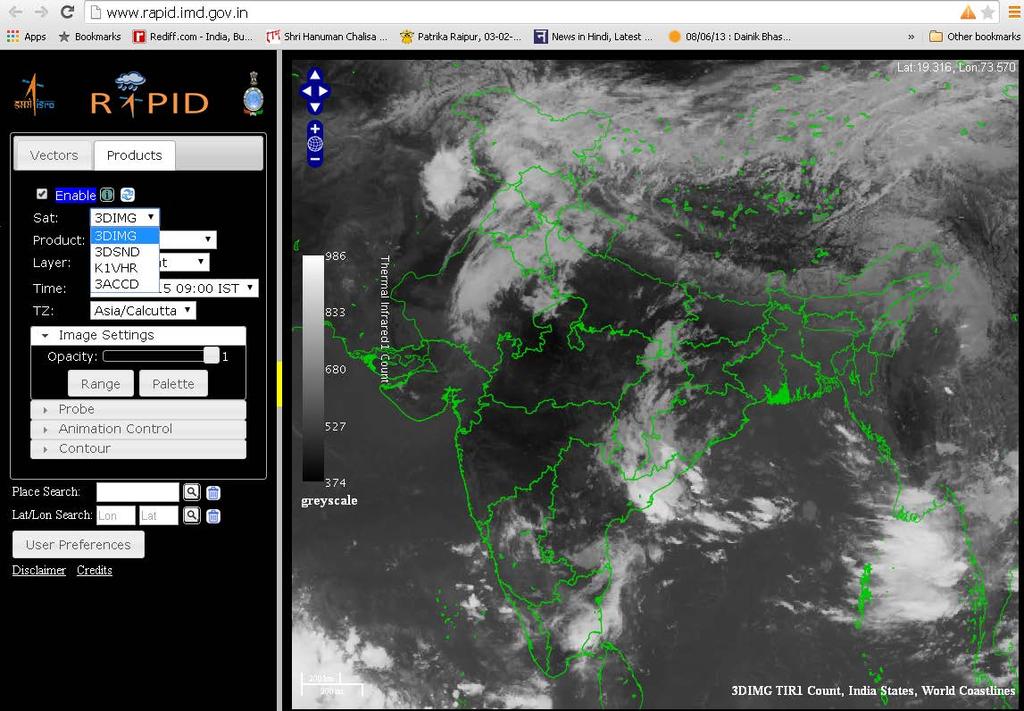
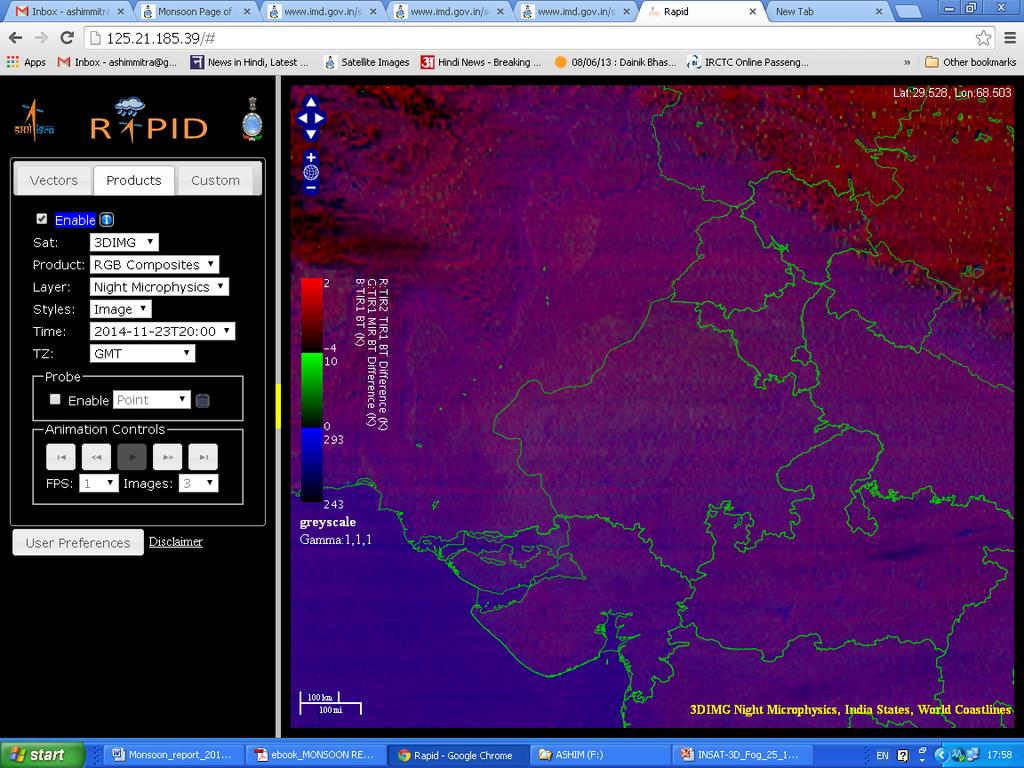
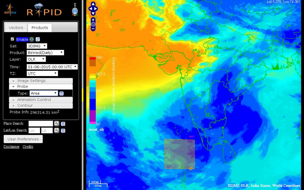
41 On-line INSAT-3D Data Visualization Tool RAPID In SATMET Division, an on-line INSAT data visualization tool called RAPID have been introduced to analyses live INSAT- 3D/3A and Kalpana-1 satellite data for weather forecast and climate studies. The software is opened on the following URL:( or and has the GIS capability to map the digital satellite data onto the user specific tasks. The software has been exclusively prepared by the SAC/ISRO team in consultation with SATMET Division. The user can see the data on half hourly, daily, weekly and monthly time period.
42
43 Difference between Fog/Haze/Cloud

44 Monthly Products such as OLR,UTH etc

45 INSAT-3D Sounder Products, Li, TPW


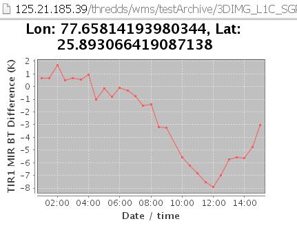
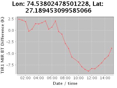
46 Rainfall analysis over Kerala


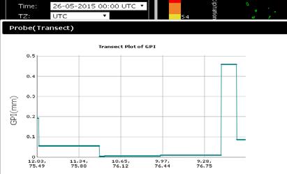
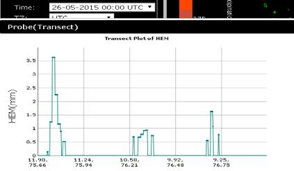
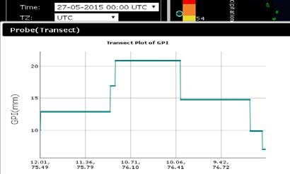
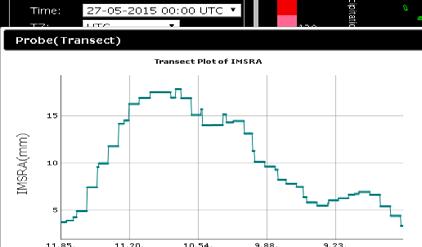
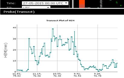
47 QPE IMSRA HEM 25/05/15 26/05/15 27/05/15


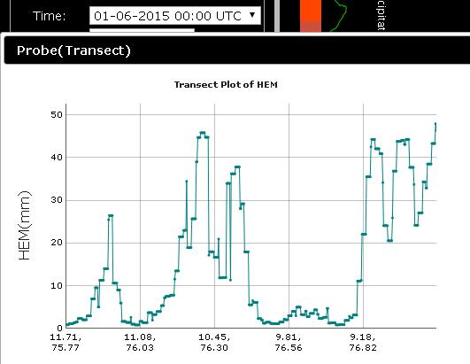
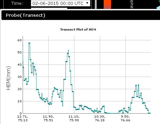
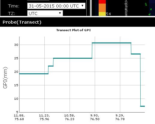
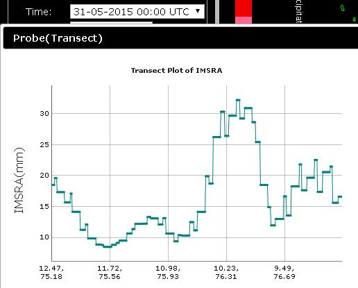
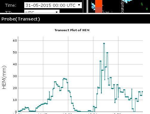
48 QPE IMSRA HEM 31/05/15 01/06/15 02/06/15

49 Pixel Level Time Series

50 OLR Monitoring

51
VALIDATION OF INSAT-3D DERIVED RAINFALL. (Submitted by Suman Goyal, IMD) Summary and Purpose of Document
 Summary and Purpose of Document") WORLD METEOROLOGICAL ORGANIZATION COMMISSION FOR BASIC SYSTEMS OPEN PROGRAMME AREA GROUP ON INTEGRATED OBSERVING SYSTEMS INTER-PROGRAMME EXPERT TEAM ON SATELLITE UTILIZATION AND PRODUCTS SECOND SESSION
WORLD METEOROLOGICAL ORGANIZATION COMMISSION FOR BASIC SYSTEMS OPEN PROGRAMME AREA GROUP ON INTEGRATED OBSERVING SYSTEMS INTER-PROGRAMME EXPERT TEAM ON SATELLITE UTILIZATION AND PRODUCTS SECOND SESSION
Satellite derived precipitation estimates over Indian region during southwest monsoons
 J. Ind. Geophys. Union ( January 2013 ) Vol.17, No.1, pp. 65-74 Satellite derived precipitation estimates over Indian region during southwest monsoons Harvir Singh 1,* and O.P. Singh 2 1 National Centre
Radiative Transfer Model based Bias Correction in INSAT-3D/3DR Thermal Observations to Improve Sea Surface Temperature Retrieval
 Radiative Transfer Model based Bias Correction in INSAT-3D/3DR Thermal Observations to Improve Sea Surface Temperature Retrieval Rishi K Gangwar, Buddhi P Jangid, and Pradeep K Thapliyal Space Applications
Update on SCOPE-Nowcasting Pilot Project Real Time Ocean Products Suman Goyal Scientist-E
 Update on SCOPE-Nowcasting Pilot Project Real Time Ocean Products Suman Goyal Scientist-E 19-22 Nov 2013 SCOPE-Nowcasting-1 Agenda Item 5 Pilot Projects Overview Users /Clients User requirements Product
Status of Indian Satellite Meteorological Programme
 Status of Indian Satellite Meteorological Programme Pradeep K Thapliyal Space Applications Centre (SAC) Indian Space research Organisation (ISRO) Ahmedabad (INDIA) Email: pkthapliyal@sac.isro.gov.in International
Lecture 19: Operational Remote Sensing in Visible, IR, and Microwave Channels
 MET 4994 Remote Sensing: Radar and Satellite Meteorology MET 5994 Remote Sensing in Meteorology Lecture 19: Operational Remote Sensing in Visible, IR, and Microwave Channels Before you use data from any
Evidence for Weakening of Indian Summer Monsoon and SA CORDEX Results from RegCM
 Evidence for Weakening of Indian Summer Monsoon and SA CORDEX Results from RegCM S K Dash Centre for Atmospheric Sciences Indian Institute of Technology Delhi Based on a paper entitled Projected Seasonal
Prediction of western disturbances and associated weather over Western Himalayas
 Prediction of western disturbances and associated weather over Western Himalayas H. R. Hatwar*, B. P. Yadav and Y. V. Rama Rao India Meteorological Department, Lodi Road, New Delhi 110 003, India Two cases
Long Range Forecast Update for 2014 Southwest Monsoon Rainfall
 Earth System Science Organization (ESSO) Ministry of Earth Sciences (MoES) India Meteorological Department PRESS RELEASE New Delhi, 9 June 2014 Long Update for 2014 Southwest Monsoon Rainfall HIGHLIGHTS
CHAPTER 8 NUMERICAL SIMULATIONS OF THE ITCZ OVER THE INDIAN OCEAN AND INDONESIA DURING A NORMAL YEAR AND DURING AN ENSO YEAR
 CHAPTER 8 NUMERICAL SIMULATIONS OF THE ITCZ OVER THE INDIAN OCEAN AND INDONESIA DURING A NORMAL YEAR AND DURING AN ENSO YEAR In this chapter, comparisons between the model-produced and analyzed streamlines,
The Abnormal Indian Summer Monsoon of 2002: JRA25 Reanalysis
 The Abnormal Indian Summer Monsoon of 2002: JRA25 Reanalysis D. Rajan 1,2, T. Koike 2, J. Matsumoto 2 1 NCMRWF, Ministry of Earth Sciences, India 2 CEOP Lab, University of Tokyo, Japan Correspondence:
Kalimantan realistically (Figs. 8.23a-d). Also, the wind speeds of the westerly
. Also, the wind speeds of the westerly") suppressed rainfall rate (maximum vertical velocity) around 17 LST (Figs. 8.21a-b). These results are in agreement with previous studies (e. g., Emanuel and Raymond 1994). The diurnal variation of maximum
suppressed rainfall rate (maximum vertical velocity) around 17 LST (Figs. 8.21a-b). These results are in agreement with previous studies (e. g., Emanuel and Raymond 1994). The diurnal variation of maximum
KUALA LUMPUR MONSOON ACTIVITY CENT
 T KUALA LUMPUR MONSOON ACTIVITY CENT 2 ALAYSIAN METEOROLOGICAL http://www.met.gov.my DEPARTMENT MINISTRY OF SCIENCE. TECHNOLOGY AND INNOVATIO Introduction Atmospheric and oceanic conditions over the tropical
Recent developments in the CMVs derived from KALPANA-1 AND INSAT-3A Satellites and their impacts on NWP Model.
 Recent developments in the CMVs derived from KALPANA-1 AND INSAT-3A Satellites and their impacts on NWP Model. By Devendra Singh, R.K.Giri and R.C.Bhatia India Meteorological Department New Delhi-110 003,
Government of India India Meteorological Department (Ministry of Earth Sciences) Subject: Current weather conditions and forecast for next two weeks
 Subject: Current weather conditions and forecast for next two weeks") Government of India India Meteorological Department (Ministry of Earth Sciences) Press Release Dated 18 June, 2010 Subject: Current weather conditions and forecast for next two weeks Advance of monsoon
Government of India India Meteorological Department (Ministry of Earth Sciences) Press Release Dated 18 June, 2010 Subject: Current weather conditions and forecast for next two weeks Advance of monsoon
CURRENT STATUS OF MONSOON Main Meteorological conditions of the last week (27August to 2 September)
") CURRENT STATUS OF MONSOON 2009 Main Meteorological conditions of the last week (27August to 2 September) Last week s low pressure area over Orissa and neighbourhood moved west-northwestwards across central
CURRENT STATUS OF MONSOON 2009 Main Meteorological conditions of the last week (27August to 2 September) Last week s low pressure area over Orissa and neighbourhood moved west-northwestwards across central
Advanced Hydrology. (Web course)
") Advanced Hydrology (Web course) Subhankar Karmakar Assistant Professor Centre for Environmental Science and Engineering (CESE) Indian Institute of Technology Bombay Powai, Mumbai 400 076 Email: skarmakar@iitb.ac.in
Advanced Hydrology (Web course) Subhankar Karmakar Assistant Professor Centre for Environmental Science and Engineering (CESE) Indian Institute of Technology Bombay Powai, Mumbai 400 076 Email: skarmakar@iitb.ac.in
Masahiro Kazumori, Takashi Kadowaki Numerical Prediction Division Japan Meteorological Agency
 Development of an all-sky assimilation of microwave imager and sounder radiances for the Japan Meteorological Agency global numerical weather prediction system Masahiro Kazumori, Takashi Kadowaki Numerical
Rainfall analysis for Indian monsoon region using the merged rain gauge observations and satellite estimates: Evaluation of monsoon rainfall features
 Rainfall analysis for Indian monsoon region using the merged rain gauge observations and satellite estimates: Evaluation of monsoon rainfall features SKRoyBhowmikand Ananda K Das India Meteorological Department,
General Circulation. Nili Harnik DEES, Lamont-Doherty Earth Observatory
 General Circulation Nili Harnik DEES, Lamont-Doherty Earth Observatory nili@ldeo.columbia.edu Latitudinal Radiation Imbalance The annual mean, averaged around latitude circles, of the balance between the
Current Status of COMS AMV in NMSC/KMA
 Current Status of COMS AMV in NMSC/KMA Eunha Sohn, Sung-Rae Chung, Jong-Seo Park Satellite Analysis Division, NMSC/KMA soneh0431@korea.kr COMS AMV of KMA/NMSC has been produced hourly since April 1, 2011.
Outgoing long wave radiation (OLR) a proxy of convection
 a proxy of convection") Outgoing long wave radiation (OLR) a proxy of convection Vijay Garg M.M.College, Modinagar, Ghaziabad Abstract: Outgoing long wave radiation (OLR) is a proxy indicator of convection. It is measured through
Outgoing long wave radiation (OLR) a proxy of convection Vijay Garg M.M.College, Modinagar, Ghaziabad Abstract: Outgoing long wave radiation (OLR) is a proxy indicator of convection. It is measured through
Remote Sensing of Precipitation
 Lecture Notes Prepared by Prof. J. Francis Spring 2003 Remote Sensing of Precipitation Primary reference: Chapter 9 of KVH I. Motivation -- why do we need to measure precipitation with remote sensing instruments?
Atmospheric Motion Vectors (AMVs) and their forecasting significance
 and their forecasting significance") Atmospheric Motion Vectors (AMVs) and their forecasting significance Vijay Garg M.M. College, Modi Nagar, Ghaziabad, Uttar Pradesh R.K. Giri Meteorological Center India Meteorological Department, Patna-14
Atmospheric Motion Vectors (AMVs) and their forecasting significance Vijay Garg M.M. College, Modi Nagar, Ghaziabad, Uttar Pradesh R.K. Giri Meteorological Center India Meteorological Department, Patna-14
RETRIEVAL AND APPLICATIONS OF ATMOSPHERIC MOTION VECTORS USING INSAT-3D/3DR DATA : ISRO STATUS
 RETRIEVAL AND APPLICATIONS OF ATMOSPHERIC MOTION VECTORS USING INSAT-3D/3DR DATA : ISRO STATUS Sanjib K Deb, D K Sankhala, C M Kishtawal Atmospheric and Oceanic Sciences Group Space Applications Centre
3. HYDROMETEROLOGY. 3.1 Introduction. 3.2 Hydro-meteorological Aspect. 3.3 Rain Gauge Stations
 3. HYDROMETEROLOGY 3.1 Introduction Hydrometeorology is a branch of meteorology and hydrology that studies the transfer of water and energy between the land surface and the lower atmosphere. Detailed hydrological
Study of the cloud cover variability over Indian region using Geo- Stationary Satellitedata
 International Archive of Applied Sciences and Technology Int. Arch. App. Sci. Technol; Vol 9 [3] September 2018 : 29-34 2018 Society of Education, India [ISO9001: 2008 Certified Organization] www.soeagra.com/iaast.html
Suppressed Surface Heating over northwestern parts of the Country and the ensuing Monsoon Rainfall
 Suppressed Surface Heating over northwestern parts of the Country and the ensuing Monsoon Rainfall During this year, the temperatures have been below normal over north and northwestern parts of India.
PRECONVECTIVE SOUNDING ANALYSIS USING IASI AND MSG- SEVIRI
 PRECONVECTIVE SOUNDING ANALYSIS USING IASI AND MSG- SEVIRI Marianne König, Dieter Klaes EUMETSAT, Eumetsat-Allee 1, 64295 Darmstadt, Germany Abstract EUMETSAT operationally generates the Global Instability
Impact of the 2002 stratospheric warming in the southern hemisphere on the tropical cirrus clouds and convective activity
 The Third International SOWER meeting,, Lake Shikotsu,, July 18-20, 2006 1 Impact of the 2002 stratospheric warming in the southern hemisphere on the tropical cirrus clouds and convective activity Eguchi,
Impact of ATOVS data in a mesoscale assimilationforecast system over the Indian region
 Impact of ATOVS data in a mesoscale assimilationforecast system over the Indian region John P. George and Munmun Das Gupta National Centre for Medium Range Weather Forecasting, Department of Science &
Indian National (Weather) SATellites for Agrometeorological Applications
 SATellites for Agrometeorological Applications") Indian National (Weather) SATellites for Agrometeorological Applications Bimal K. Bhattacharya Agriculture-Terrestrial Biosphere- Hydrology Group Space Applications Centre (ISRO) Ahmedabad 380015, India
Indian National (Weather) SATellites for Agrometeorological Applications Bimal K. Bhattacharya Agriculture-Terrestrial Biosphere- Hydrology Group Space Applications Centre (ISRO) Ahmedabad 380015, India
Lecture 8. Monsoons and the seasonal variation of tropical circulation and rainfall
 Lecture 8 Monsoons and the seasonal variation of tropical circulation and rainfall According to the second hypothesis, the monsoon is a manifestation of the seasonal variation of the tropical circulation
EVALUATION OF BROAD SCALE VERTICAL CIRCULATION AND THERMAL INDICES IN RELATION TO THE ONSET OF INDIAN SUMMER MONSOON
 INTERNATIONAL JOURNAL OF CLIMATOLOGY Int. J. Climatol. 22: 649 661 (2002) Published online in Wiley InterScience (www.interscience.wiley.com). DOI: 10.1002/joc.742 EVALUATION OF BROAD SCALE VERTICAL CIRCULATION
INDIA METEOROLOGICAL DEPARTMENT (MINISTRY OF EARTH SCIENCES) SOUTHWEST MONSOON-2014 END OF SEASON REPORT For the state of RAJASTHAN
 SOUTHWEST MONSOON-2014 END OF SEASON REPORT For the state of RAJASTHAN") INDIA METEOROLOGICAL DEPARTMENT (MINISTRY OF EARTH SCIENCES) SOUTHWEST MONSOON-2014 END OF SEASON REPORT For the state of RAJASTHAN HIGHLIGHTS For the country as a whole, the rainfall for the season (June-September)
INDIA METEOROLOGICAL DEPARTMENT (MINISTRY OF EARTH SCIENCES) SOUTHWEST MONSOON-2014 END OF SEASON REPORT For the state of RAJASTHAN HIGHLIGHTS For the country as a whole, the rainfall for the season (June-September)
ISRO Report on the Status of Current and future satellites. Presented to CGMS-44 WP-01 Plenary Session
 ISRO Report on the Status of Current and future satellites Presented to CGMS-44 WP-01 Plenary Session CGMS-44-ISRO 05-10 June 2016 Indian Satellite System for weather parameters Satellite Oceansat-1/ MSMR
Operational Uses of Bands on the GOES-R Advanced Baseline Imager (ABI) Presented by: Kaba Bah
 Presented by: Kaba Bah") Operational Uses of Bands on the GOES-R Advanced Baseline Imager (ABI) Presented by: Kaba Bah Topics: Introduction to GOES-R & ABI ABI individual bands Use of band differences ABI derived products Conclusions
Operational Uses of Bands on the GOES-R Advanced Baseline Imager (ABI) Presented by: Kaba Bah Topics: Introduction to GOES-R & ABI ABI individual bands Use of band differences ABI derived products Conclusions
Atmospheric Motion Vectors from Kalpana-1: An ISRO status
 Atmospheric Motion Vectors from Kalpana-1: An ISRO status Sanjib Kr. Deb, Inderpreet Kaur, C. M. Kishtawal and P. K. Pal Atmospheric and Oceanic Sciences Group Space Applications Centre Indian Space Research
Latest status and developments at IMD since CGMS-45
 Latest status and developments at IMD since CGMS-45 CGMS-46, Plenary session, agenda item IMD-ISRO-WP-01 Presenter: S K Peshin Report Prepared By: S K Peshin, Virendra Singh, A.K.Mitra Overview - Planning
Key Finding: Long Term Trend During 2014: Rain in Indian Tradition Measuring Rain
 Chapter 34 RAINFALL Key Finding: Long Term Trend Despite of theories suggesting increase in rainfall in Asian Region due to global warming, no significant trend has been observed at all India level (confirmed
Application of Himawari-8 AHI Data to the GOES-R Rainfall Rate Algorithm
 Application of Himawari-8 AHI Data to the GOES-R Rainfall Rate Algorithm Yaping Li 1, Robert Kuligowski 2 and Yan Hao 1 1. IMSG at NOAA/NESDIS/STAR 2. NOAA/NESDIS/STAR, College Park, MD 1 GOES-R Baseline
Thai Meteorological Department, Ministry of Digital Economy and Society
 Thai Meteorological Department, Ministry of Digital Economy and Society Three-month Climate Outlook For November 2017 January 2018 Issued on 31 October 2017 -----------------------------------------------------------------------------------------------------------------------------
Transient and Eddy. Transient/Eddy Flux. Flux Components. Lecture 3: Weather/Disturbance. Transient: deviations from time mean Time Mean
 Lecture 3: Weather/Disturbance Transients and Eddies Climate Roles Mid-Latitude Cyclones Tropical Hurricanes Mid-Ocean Eddies Transient and Eddy Transient: deviations from time mean Time Mean Eddy: deviations
R.C.BHATIA, P.N. Khanna and Sant Prasad India Meteorological Department, Lodi Road, New Delhi ABSTRACT
 Improvements in Automated Cloud Motion Vectors ---------------------------------------------- (CMVs) derivation scheme using INSAT VHRR data. ---------------------------------------------- by R.C.BHATIA,
MAIN ATTRIBUTES OF THE PRECIPITATION PRODUCTS DEVELOPED BY THE HYDROLOGY SAF PROJECT RESULTS OF THE VALIDATION IN HUNGARY
 MAIN ATTRIBUTES OF THE PRECIPITATION PRODUCTS DEVELOPED BY THE HYDROLOGY SAF PROJECT RESULTS OF THE VALIDATION IN HUNGARY Eszter Lábó OMSZ-Hungarian Meteorological Service, Budapest, Hungary labo.e@met.hu
CPTEC and NCEP Model Forecast Drift and South America during the Southern Hemisphere Summer
 CPTEC and NCEP Model Forecast Drift and South America during the Southern Hemisphere Summer José Antonio Aravéquia 1 Pedro L. Silva Dias 2 (1) Center for Weather Forecasting and Climate Research National
First results from a new observational system over the Indian seas
 PERSPECTIVES ON OCEAN RESEARCH IN INDIA First results from a new observational system over the Indian seas K. Premkumar, M. Ravichandran, S. R. Kalsi*, Debasis Sengupta** and Sulochana Gadgil**, National
IMPACT OF KALPANA-1 CLOUD MOTION VECTORS IN THE NUMERICAL WEATHER PREDICTION OF INDIAN SUMMER MONSOON
 IMPACT OF KALPANA-1 CLOUD MOTION VECTORS IN THE NUMERICAL WEATHER PREDICTION OF INDIAN SUMMER MONSOON S.K.Roy Bhowmik, D. Joardar, Rajeshwar Rao, Y.V. Rama Rao, S. Sen Roy, H.R. Hatwar and Sant Prasad
NEW SCHEME TO IMPROVE THE DETECTION OF RAINY CLOUDS IN PUERTO RICO
 NEW SCHEME TO IMPROVE THE DETECTION OF RAINY CLOUDS IN PUERTO RICO Joan Manuel Castro Sánchez Advisor Dr. Nazario Ramirez UPRM NOAA CREST PRYSIG 2016 October 7, 2016 Introduction A cloud rainfall event
NOTES AND CORRESPONDENCE. A Pronounced Continental-Scale Diurnal Mode of the Asian Summer Monsoon
 462 MONTHLY WEATHER REVIEW VOLUME 128 NOTES AND CORRESPONDENCE A Pronounced Continental-Scale Diurnal Mode of the Asian Summer Monsoon T. N. KRISHNAMURTI AND C. M. KISHTAWAL Department of Meteorology,
NEW APPROACH FOR HEIGHT ASSIGNMENT AND STRINGENT QUALITY CONTROL TESTS FOR INSAT DERIVED CLOUD MOTION VECTORS. P. N. Khanna, S.
 NEW APPROACH FOR HEIGHT ASSIGNMENT AND STRINGENT QUALITY CONTROL TESTS FOR INSAT DERIVED CLOUD MOTION VECTORS P. N. Khanna, S. Prasad India Meteorological Department, Lodhi Road, New Delhi 110003. ABSTRACT
REVISION OF THE STATEMENT OF GUIDANCE FOR GLOBAL NUMERICAL WEATHER PREDICTION. (Submitted by Dr. J. Eyre)
") WORLD METEOROLOGICAL ORGANIZATION Distr.: RESTRICTED CBS/OPAG-IOS (ODRRGOS-5)/Doc.5, Add.5 (11.VI.2002) COMMISSION FOR BASIC SYSTEMS OPEN PROGRAMME AREA GROUP ON INTEGRATED OBSERVING SYSTEMS ITEM: 4 EXPERT
WORLD METEOROLOGICAL ORGANIZATION Distr.: RESTRICTED CBS/OPAG-IOS (ODRRGOS-5)/Doc.5, Add.5 (11.VI.2002) COMMISSION FOR BASIC SYSTEMS OPEN PROGRAMME AREA GROUP ON INTEGRATED OBSERVING SYSTEMS ITEM: 4 EXPERT
Long Range Forecasts of 2015 SW and NE Monsoons and its Verification D. S. Pai Climate Division, IMD, Pune
 Long Range Forecasts of 2015 SW and NE Monsoons and its Verification D. S. Pai Climate Division, IMD, Pune Other Contributors: Soma Sen Roy, O. P. Sreejith, Kailas, Madhuri, Pallavi, Mahendra and Jasmine
Study of Hydrometeorology in a Hard Rock Terrain, Kadirischist Belt Area, Anantapur District, Andhra Pradesh
 Open Journal of Geology, 2012, 2, 294-300 http://dx.doi.org/10.4236/ojg.2012.24028 Published Online October 2012 (http://www.scirp.org/journal/ojg) Study of Hydrometeorology in a Hard Rock Terrain, Kadirischist
Analysis of Heavy Precipitation Events Over Western Himalayan Region
 INTERNATIONAL JOURNAL OF EARTH AND ATMOSPHERIC SCIENCE Journal homepage: www.jakraya.com/journal/ijeas Analysis of Heavy Precipitation Events Over Western Himalayan Region B.P. Yadav, Naresh Kumar and
Assimilation of precipitation-related observations into global NWP models
 Assimilation of precipitation-related observations into global NWP models Alan Geer, Katrin Lonitz, Philippe Lopez, Fabrizio Baordo, Niels Bormann, Peter Lean, Stephen English Slide 1 H-SAF workshop 4
Nerushev A.F., Barkhatov A.E. Research and Production Association "Typhoon" 4 Pobedy Street, , Obninsk, Kaluga Region, Russia.
 DETERMINATION OF ATMOSPHERIC CHARACTERISTICS IN THE ZONE OF ACTION OF EXTRA-TROPICAL CYCLONE XYNTHIA (FEBRUARY 2010) INFERRED FROM SATELLITE MEASUREMENT DATA Nerushev A.F., Barkhatov A.E. Research and
For the operational forecaster one important precondition for the diagnosis and prediction of
 Initiation of Deep Moist Convection at WV-Boundaries Vienna, Austria For the operational forecaster one important precondition for the diagnosis and prediction of convective activity is the availability
Interpretation of Polar-orbiting Satellite Observations. Atmospheric Instrumentation
 Interpretation of Polar-orbiting Satellite Observations Outline Polar-Orbiting Observations: Review of Polar-Orbiting Satellite Systems Overview of Currently Active Satellites / Sensors Overview of Sensor
INFLUENCE OF LARGE-SCALE ATMOSPHERIC MOISTURE FLUXES ON THE INTERANNUAL TO MULTIDECADAL RAINFALL VARIABILITY OF THE WEST AFRICAN MONSOON
 3C.4 INFLUENCE OF LARGE-SCALE ATMOSPHERIC MOISTURE FLUXES ON THE INTERANNUAL TO MULTIDECADAL RAINFALL VARIABILITY OF THE WEST AFRICAN MONSOON Andreas H. Fink*, and Sonja Eikenberg University of Cologne,
Seasonal Climate Outlook for South Asia (June to September) Issued in May 2014
 Issued in May 2014") Ministry of Earth Sciences Earth System Science Organization India Meteorological Department WMO Regional Climate Centre (Demonstration Phase) Pune, India Seasonal Climate Outlook for South Asia (June
Ministry of Earth Sciences Earth System Science Organization India Meteorological Department WMO Regional Climate Centre (Demonstration Phase) Pune, India Seasonal Climate Outlook for South Asia (June
Vertical wind shear in relation to frequency of Monsoon Depressions and Tropical Cyclones of Indian Seas
 Vertical wind shear in relation to frequency of Monsoon Depressions and Tropical Cyclones of Indian Seas Prince K. Xavier and P.V. Joseph Department of Atmospheric Sciences Cochin University of Science
Simulation and Validation of INSAT-3D sounder data at NCMRWF
 Simulation and Validation of INSAT-3D sounder data at NCMRWF S. Indira Rani and V. S. Prasad National Centre for Medium Range Weather Forecasting (NCMRWF) Earth System Science Organization (ESSO) Ministry
CHAPTER 2 DATA AND METHODS. Errors using inadequate data are much less than those using no data at all. Charles Babbage, circa 1850
 CHAPTER 2 DATA AND METHODS Errors using inadequate data are much less than those using no data at all. Charles Babbage, circa 185 2.1 Datasets 2.1.1 OLR The primary data used in this study are the outgoing
M. Mohapatra and D. R. Pattanaik
 Understanding and forecasting of intra-seasonal extremes of southwest monsoon circulation and precipitation over India M. Mohapatra and D. R. Pattanaik IMD, New Delhi Email : m.mohapatra@imd.gov.in Annual
NUMERICAL EXPERIMENTS USING CLOUD MOTION WINDS AT ECMWF GRAEME KELLY. ECMWF, Shinfield Park, Reading ABSTRACT
 NUMERICAL EXPERIMENTS USING CLOUD MOTION WINDS AT ECMWF GRAEME KELLY ECMWF, Shinfield Park, Reading ABSTRACT Recent monitoring of cloud motion winds (SATOBs) at ECMWF has shown an improvement in quality.
McIDAS support of Suomi-NPP /JPSS and GOES-R L2
 McIDAS support of Suomi-NPP /JPSS and GOES-R L2 William Straka III 1 Tommy Jasmin 1, Bob Carp 1 1 Cooperative Institute for Meteorological Satellite Studies, Space Science and Engineering Center, University
H-SAF future developments on Convective Precipitation Retrieval
 H-SAF future developments on Convective Precipitation Retrieval Francesco Zauli 1, Daniele Biron 1, Davide Melfi 1, Antonio Vocino 1, Massimiliano Sist 2, Michele De Rosa 2, Matteo Picchiani 2, De Leonibus
7 December 2016 Tokyo Climate Center, Japan Meteorological Agency
 Summary of the 2016 Asian Summer Monsoon 7 December 2016 Tokyo Climate Center, Japan Meteorological Agency This report summarizes the characteristics of the surface climate and atmospheric/oceanographic
Characteristics of Global Precipitable Water Revealed by COSMIC Measurements
 Characteristics of Global Precipitable Water Revealed by COSMIC Measurements Ching-Yuang Huang 1,2, Wen-Hsin Teng 1, Shu-Peng Ho 3, Ying-Hwa Kuo 3, and Xin-Jia Zhou 3 1 Department of Atmospheric Sciences,
A High Resolution Daily Gridded Rainfall Data Set ( ) for Mesoscale Meteorological Studies
 for Mesoscale Meteorological Studies") National Climate Centre Research Report No: 9/2008 A High Resolution Daily Gridded Rainfall Data Set (1971-2005) for Mesoscale Meteorological Studies M. Rajeevan and Jyoti Bhate National Climate Centre
National Climate Centre Research Report No: 9/2008 A High Resolution Daily Gridded Rainfall Data Set (1971-2005) for Mesoscale Meteorological Studies M. Rajeevan and Jyoti Bhate National Climate Centre
Tropical Cyclones. Objectives
 Tropical Cyclones FIU Undergraduate Hurricane Internship Lecture 2 8/8/2012 Objectives From this lecture you should understand: Global tracks of TCs and the seasons when they are most common General circulation
Verification of the Seasonal Forecast for the 2005/06 Winter
 Verification of the Seasonal Forecast for the 2005/06 Winter Shingo Yamada Tokyo Climate Center Japan Meteorological Agency 2006/11/02 7 th Joint Meeting on EAWM Contents 1. Verification of the Seasonal
Government of Sultanate of Oman Public Authority of Civil Aviation Directorate General of Meteorology. National Report To
 Government of Sultanate of Oman Public Authority of Civil Aviation Directorate General of Meteorology National Report To Panel on Tropical Cyclones in the Bay of Bengal And Arabian Sea 43rd Session, India
Fluid Circulation Review. Vocabulary. - Dark colored surfaces absorb more energy.
 Fluid Circulation Review Vocabulary Absorption - taking in energy as in radiation. For example, the ground will absorb the sun s radiation faster than the ocean water. Air pressure Albedo - Dark colored
Analysis on MM5 predictions at Sriharikota during northeast monsoon 2008
 Analysis on MM5 predictions at Sriharikota during northeast monsoon 8 D Gayatri Vani, S Rambabu, M Rajasekhar, GVRama, B V Apparao and A K Ghosh MET-Facility, Satish Dhawan Space Centre, SHAR, ISRO, Sriharikota
Lecture 4b: Meteorological Satellites and Instruments. Acknowledgement: Dr. S. Kidder at Colorado State Univ.
 Lecture 4b: Meteorological Satellites and Instruments Acknowledgement: Dr. S. Kidder at Colorado State Univ. US Geostationary satellites - GOES (Geostationary Operational Environmental Satellites) US
Daniel J. Cecil 1 Mariana O. Felix 1 Clay B. Blankenship 2. University of Alabama - Huntsville. University Space Research Alliance
 12A.4 SEVERE STORM ENVIRONMENTS ON DIFFERENT CONTINENTS Daniel J. Cecil 1 Mariana O. Felix 1 Clay B. Blankenship 2 1 University of Alabama - Huntsville 2 University Space Research Alliance 1. INTRODUCTION
Page 1. Name:
 Name: 1) As the difference between the dewpoint temperature and the air temperature decreases, the probability of precipitation increases remains the same decreases 2) Which statement best explains why
Correspondence between short and long timescale systematic errors in CAM4/CAM5 explored by YOTC data
 Correspondence between short and long timescale systematic errors in CAM4/CAM5 explored by YOTC data Hsi-Yen Ma In collaboration with Shaocheng Xie, James Boyle, Stephen Klein, and Yuying Zhang Program
Intraseasonal and Seasonally Persisting Patterns of Indian Monsoon Rainfall
 1 JANUARY 2007 K R I S H N A M U R T H Y A N D S H U K L A 3 Intraseasonal and Seasonally Persisting Patterns of Indian Monsoon Rainfall V. KRISHNAMURTHY AND J. SHUKLA Center for Ocean Land Atmosphere
P1.34 MULTISEASONALVALIDATION OF GOES-BASED INSOLATION ESTIMATES. Jason A. Otkin*, Martha C. Anderson*, and John R. Mecikalski #
 P1.34 MULTISEASONALVALIDATION OF GOES-BASED INSOLATION ESTIMATES Jason A. Otkin*, Martha C. Anderson*, and John R. Mecikalski # *Cooperative Institute for Meteorological Satellite Studies, University of
APPLICATIONS WITH METEOROLOGICAL SATELLITES. W. Paul Menzel. Office of Research and Applications NOAA/NESDIS University of Wisconsin Madison, WI
 APPLICATIONS WITH METEOROLOGICAL SATELLITES by W. Paul Menzel Office of Research and Applications NOAA/NESDIS University of Wisconsin Madison, WI July 2004 Unpublished Work Copyright Pending TABLE OF CONTENTS
ROLE OF SATELLITE DERIVED PRODUCTS IN MONITORING THE FOG AT JPNI AIRPORT PATNA
 ROLE OF SATELLITE DERIVED PRODUCTS IN MONITORING THE FOG AT JPNI AIRPORT PATNA *Giri R.K. 1, Devendra, Pradhan 2 and Sen A.K. 1 1 Meteorological Centre, Patna (Bihar)-India 2 Regional Meteorological Centre,
UPDATE OF REGIONAL WEATHER AND SMOKE HAZE (September 2017)
") UPDATE OF REGIONAL WEATHER AND SMOKE HAZE (September 2017) 1. Review of Regional Weather Conditions in August 2017 1.1 Southwest Monsoon conditions continued to prevail in the region in August 2017. The
UPDATE OF REGIONAL WEATHER AND SMOKE HAZE (September 2017) 1. Review of Regional Weather Conditions in August 2017 1.1 Southwest Monsoon conditions continued to prevail in the region in August 2017. The
Data Format and Visualization Agenda
 Data Format and Visualization Agenda- 7.2.2 ET-SUP-8 (14.04.2014) Suman Goyal, Satellite Meteorology Division, India Meteorological Department, Suman_goyal61@yahoo.co.in Visualization Methods The satellite
PROJECT REPORT (ASL 720) CLOUD CLASSIFICATION
 CLOUD CLASSIFICATION") PROJECT REPORT (ASL 720) CLOUD CLASSIFICATION SUBMITTED BY- PRIYANKA GUPTA 2011CH70177 RINI KAPOOR 2011CH70179 INDIVIDUAL CONTRIBUTION- Priyanka Gupta- analysed data of region considered in India (West:80,
PROJECT REPORT (ASL 720) CLOUD CLASSIFICATION SUBMITTED BY- PRIYANKA GUPTA 2011CH70177 RINI KAPOOR 2011CH70179 INDIVIDUAL CONTRIBUTION- Priyanka Gupta- analysed data of region considered in India (West:80,
STATISTICAL ANALYSIS ON SEVERE CONVECTIVE WEATHER COMBINING SATELLITE, CONVENTIONAL OBSERVATION AND NCEP DATA
 12.12 STATISTICAL ANALYSIS ON SEVERE CONVECTIVE WEATHER COMBINING SATELLITE, CONVENTIONAL OBSERVATION AND NCEP DATA Zhu Yaping, Cheng Zhoujie, Liu Jianwen, Li Yaodong Institute of Aviation Meteorology
A two-season impact study of the Navy s WindSat surface wind retrievals in the NCEP global data assimilation system
 A two-season impact study of the Navy s WindSat surface wind retrievals in the NCEP global data assimilation system Li Bi James Jung John Le Marshall 16 April 2008 Outline WindSat overview and working
Severe storms over the Mediterranean Sea: A satellite and model analysis
 National Research Council of Italy Severe storms over the Mediterranean Sea: A satellite and model analysis V. Levizzani, S. Laviola, A. Malvaldi, M. M. Miglietta, and E. Cattani 6 th International Precipitation
Charles Jones ICESS University of California, Santa Barbara CA Outline
 The Influence of Tropical Variations on Wintertime Precipitation in California: Pineapple express, Extreme rainfall Events and Long-range Statistical Forecasts Charles Jones ICESS University of California,
Use and impact of satellite data in the NZLAM mesoscale model for the New Zealand region
 Use and impact of satellite data in the NZLAM mesoscale model for the New Zealand region V. Sherlock, P. Andrews, H. Oliver, A. Korpela and M. Uddstrom National Institute of Water and Atmospheric Research,
Reprint 850. Within the Eye of Typhoon Nuri in Hong Kong in C.P. Wong & P.W. Chan
 Reprint 850 Remote Sensing Observations of the Subsidence Zone Within the Eye of Typhoon Nuri in Hong Kong in 2008 C.P. Wong & P.W. Chan 8 th International Symposium on Tropospheric Profiling: Integration
May 3, :41 AOGS - AS 9in x 6in b951-v16-ch13 LAND SURFACE ENERGY BUDGET OVER THE TIBETAN PLATEAU BASED ON SATELLITE REMOTE SENSING DATA
 Advances in Geosciences Vol. 16: Atmospheric Science (2008) Eds. Jai Ho Oh et al. c World Scientific Publishing Company LAND SURFACE ENERGY BUDGET OVER THE TIBETAN PLATEAU BASED ON SATELLITE REMOTE SENSING
RETRIEVAL AND VALIDATION OF CLOUD MOTION VECTORS USING INFRARED DATA FROM KALPANA-1 SATELLITE
 RETRIEVAL AND VALIDATION OF CLOUD MOTION VECTORS USING INFRARED DATA FROM KALPANA-1 SATELLITE Sant Prasad, Devendra Singh, Y.V.Rama Rao and V. Rajeswara Rao India Meteorological Department, New Delhi-110
DERIVED FROM SATELLITE DATA
 P6.17 INTERCOMPARISON AND DIAGNOSIS OF MEI-YU RAINFALL DERIVED FROM SATELLITE DATA Y. Zhou * Department of Meteorology, University of Maryland, College Park, Maryland P. A. Arkin ESSIC, University of Maryland,
W E E K L Y MONSOON INSIGHT
 W E E K L Y MONSOON INSIGHT 08 th July 2016 Indian Monsoon Dynamics Recent Weather Development India received 35% surplus rainfall in the week ended 6 July with all regions recording above-normal rainfall
Mid-Latitude Cyclones and Fronts. Lecture 12 AOS 101
 Mid-Latitude Cyclones and Fronts Lecture 12 AOS 101 Homework 4 COLDEST TEMPS GEOSTROPHIC BALANCE Homework 4 FASTEST WINDS L Consider an air parcel rising through the atmosphere The parcel expands as it
APPENDIX 2 OVERVIEW OF THE GLOBAL PRECIPITATION MEASUREMENT (GPM) AND THE TROPICAL RAINFALL MEASURING MISSION (TRMM) 2-1
 AND THE TROPICAL RAINFALL MEASURING MISSION (TRMM) 2-1") APPENDIX 2 OVERVIEW OF THE GLOBAL PRECIPITATION MEASUREMENT (GPM) AND THE TROPICAL RAINFALL MEASURING MISSION (TRMM) 2-1 1. Introduction Precipitation is one of most important environmental parameters.
APPENDIX 2 OVERVIEW OF THE GLOBAL PRECIPITATION MEASUREMENT (GPM) AND THE TROPICAL RAINFALL MEASURING MISSION (TRMM) 2-1 1. Introduction Precipitation is one of most important environmental parameters.
Multiscale Analyses of Inland Tropical Cyclone Midlatitude Jet Interactions: Camille (1969) and Danny (1997)
 and Danny (1997)") Multiscale Analyses of Inland Tropical Cyclone Midlatitude Jet Interactions: Camille (1969) and Danny (1997) Matthew Potter, Lance Bosart, and Daniel Keyser Department of Atmospheric and Environmental
Multiscale Analyses of Inland Tropical Cyclone Midlatitude Jet Interactions: Camille (1969) and Danny (1997) Matthew Potter, Lance Bosart, and Daniel Keyser Department of Atmospheric and Environmental