Recent developments in the CMVs derived from KALPANA-1 AND INSAT-3A Satellites and their impacts on NWP Model.
|
|
|
- Bennett Anthony
- 6 years ago
- Views:
Transcription
1 Recent developments in the CMVs derived from KALPANA-1 AND INSAT-3A Satellites and their impacts on NWP Model. By Devendra Singh, R.K.Giri and R.C.Bhatia India Meteorological Department New Delhi , INDIA ABSTRACT The derivation of Cloud Motion Vectors (CMVs) using infrared data has been started from Kalpana-1 in April 2003 and from INSAT-3A recently. In the present technique, the quality check of CMVs was carried out with LAM Model forecast data, which covers the area 40E-129E and 29S-45N). The CMVs derived below the 29-degree south were rejected due to non availability of LAM Model forecast data. Recently, the LAM Model forecast is replaced by global forecast and therefore CMVs are now derived over larger area (40E-129E and 45S-45N) resulting a significant increase in the number of good quality CMVs. These CMVs are put on GTS for end users. The Integrated Satellite Wind Monitoring NWP SAF site has recently started storing and monitoring of Kalpana-1 and INSAT-3A derived CMVs. The statistical error analysis has been carried out for the CMVs with different NWP models in order to identify and distinguish error contributions from satellite winds and NWP models. Further, in this paper, we have examined the impact of these data in the MM5 NWP model for a cyclone case study. This study demonstrates the impact of these data in the model to capture wind circulation, surface pressure and rainfall. The impact of additional CMVs data in the model is found positive and beneficial. 1. Introduction: One of the key meteorological parameters for weather forecasting, meteorological studies and climate applications is wind. It has therefore been a major task for the science and operational community to exploit the imagery data from geostationary satellites in order to derive Atmospheric Motion Vectors (AMVs) by tracking observed cloud and moisture features. The globally derived AMV fields are an established and essential product, especially for Numerical Weather Prediction, and are complemented by other satellitebased observations of the atmospheric flow. The biennial International Winds Workshops provide a forum used for cooperation in the operational and research community and have strongly contributed to the improvement in the quality of the derived wind fields. Ever since the non-availability of data from INSAT-1D, India was looking forward for a suitable substitute to give continuity to its space observations related to weather. India took a leap when it could place 950 kg. weighing exclusive meteorological satellite
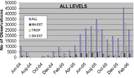
2 in space by using its own launch vehicle namely Polar Satellite Launch Vehicle (PSLV) in the month of September This Satellite namely Kalpana-1 named after the Indian born US Astronaut Kalpana Chawala who lost her life during the return flight of Space Shuttle as a tribute to her. This satellite has a payload called Very High Resolution Radiometer (VHRR) with three channels viz. Visible (0.55µ-0.75µ), Infrared (10.5µ- 12.5µ) and Water Vapour (5.7µ- 7.1µ) with a ground resolution of 2 km,8 km and 8 km respectively. After Kalpana-1 satellite became operational in the month of October 2002, IMD began deriving Cloud Motion Vectors(CMV) from the Infrared data, twice a day from the triplets at 23:30, 00:00 and 00:30 UTC and 07:00, 07:30 and 08:00 UTC. The history of CMV derivation in IMD from INSAT data started with Kelkar et.al(1986) using pattern matching by searching equality in pixel to pixel between tracer and target images. Before the computation of Cloud Motion Vector, the classification of the tracked sub-set is performed. This is basically a validation step so as to ensure that the same cloud pattern was tracked. For each of the tracked cloud target, the four-bin histogram is generated as was done for the cloud tracer and the same classification criteria is applied. The cloud target is rejected if it is not of the type of cloud tracer. The centre of the reference / search window is the initial point of the vector and the location for which absolute maximum peak is obtained as the final position of the vector. From these positions, CMV is calculated. If correlation returns multiple locations with the same maximum value, the first one is accepted. Height assignment of the CMV s is being done using Infrared Window (IRW) technique at present. Mean temperature of the 25% coldest IR pixels (John LeMarshal et al. 1993, Merrill R 1989, Nieman S. J et al. 1997) is considered for assigning the height of the CMV. With the inception of IMDPS, cross correlation technique is being used for pattern matching. Several improvements have been carried out by various scientists (Bhatia et.al 1996, Khanna et.al 1998, Khanna et.al 2000,Bhatia et al., 2002,Singh et al., 2006) with better results and reduced rms errors and biases.the software of the system is being upgraded and the H2O- IRW Intercept Method will also be tried shortly. 2. Improvements of CMVs over Southern hemisphere In the present technique, the quality check of CMVs was carried out with LAM Model forecast data, which covers the area 40E-129E and 29S-45N). The CMVs derived below the 29-degree south were rejected due to non availability of LAM Model forecast data. Recently, the LAM Model forecast is replaced by global forecast and therefore CMVs are now derived over larger area (40E-129E and 45S-45N) resulting a significant increase in the number of good quality CMVs. The figure-1 (a and b) depicts the comparisons after extending the area up to 45 degree south. The derivation of winds over this extended area do not show zonal flow reported earlier. Actually it was not a zonal flow in the CMVs but because of the chopped area, it appeared like zonal flow. Due to increase in area, the increase in number of CMVs are confined only for lower and middle levels and not found at the higher levels as shown in figure 2(a and b) and figure 2(c) respectively.
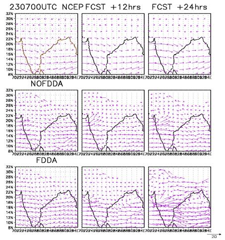
3 3. Intercomparision of CMVs with Meteosat-5 Monthly Statistics on rms errors and biases generated by NWP SAF was used for this purpose and a comparison of Kalpana-1 derived CMVs was made with METEOSAT-5 derived CMVs. The rmse of CMVs derived from Kalpana-1 against UK Model and IMD Model were generated for the comparisons. Fig. 3(a,b,c and d) depict monthly statistics for the period march 2005 to Feb, 2006 for different pressure levels. It is seen that from these figures that rmse for all the three levels (low, medium and high) and at different regions are slightly larger by about 1.5 m/sec compared to Meteosat-5. Largest differences have been observed over southern hemisphere extra tropics about the order of 2m/sec. This could be due to very small number of CMVs over this area. Further, theses differences are larger compared to UK Model analysis. This is because the IMD model assimilates Kalpana-1 satellite derived CMVs and these are not assimilated in UK Model. 3. Impact of CMV s on MM5 Model The present study utilized the MM5 version 3.6. The model was configured with twenty three vertical layers (centered at sigma = 0.995, 0.985, 0.97, 0.945, 0.91, 0.87, 0.825, 0.775, 0.725, 0.675, 0.625, 0.575, 0.525, 0.475, 0.425, 0.375, 0.325, 0.275, 0.225, 0.175, 0.125, 0.075, 0.025) and two nested domains (Outer Domain: 90 km grid spacing with 85 x 75 grid cells in east-west and north-south directions; Inner Domain: 30 km grid spacing with 130 x 118 grid cells in the east-west and north-south directions). Other model settings included: MRF PBL scheme, the Grell cumulus scheme, a mixed phase Reisner scheme for explicit moisture, a cloud radiation scheme and a multi-level soil model. The NCEP reanalysis data available at a horizontal resolution of 2.5 o lat x 2.5 o lon and a time resolution of 6 hours were used to develop the initial and lateral boundary conditions. A one-way nesting option was employed. Two numerical experiments were designed to study the effect of the ingestion and assimilation of the INSAT CMV winds, QuikSCAT surface wind vector over the oceans and IMD surface and upper air wind data on the prediction of a monsoon depression, which formed in the Bay of Bengal during July The first experiment (called no FDDA run) utilized the NCEP reanalysis for the initial and lateral boundary conditions and the MM5 model integrations were performed from 22 July UTC to 25 July UTC. The second numerical experiment (called FDDA run) ingested and assimilated INSAT CMV winds, QuikSCAT surface wind vector over the oceans and IMD surface and upper air wind data for the time period between 22 July UTC to 23 July UTC to improve the NCEP reanalysis. The MM5 model was subsequently run in a free forecast mode from 23 July UTC to 25 July UTC. The results of the MM5 simulation corresponding to the two numerical experiments were then compared with NCEP reanalysis as well as with observations for the time period between 23 July UTC to 25 July UTC. All the MM5 results depicted are from the 30km domain only.

 is unable to simulate the large-scale structure of the SLP pattern with the SLP corresponding to the depression higher by as much as")
 and 6(a and b) except that the former depict lower tropospheric winds (sigma level = 0.995) as well as 24 hour accumulated rainfall.")

4 Figure 5(a and b) depict the sea level pressure (SLP) field at 00 and 12 UTC for July The top panels show the SLP from the NCEP reanalysis while the middle and bottom panels show the SLP from the MM5 simulations without and with FDDA. Figure 2 is similar to Figure 1 except for 12 and 00 UTC for July It is clear from both the figures that middle panels (no FDDA run) is unable to simulate the large-scale structure of the SLP pattern with the SLP corresponding to the depression higher by as much as 4 hpa as compared to the lower panels (FDDA run). On the other hand, the lower panels (FDDA run) reproduce the large-scale structure of the SLP pattern and is closer to the NCEP reanalysis. Figure 3 and 4 are similar to Figures 5(a and b) and 6(a and b) except that the former depict lower tropospheric winds (sigma level = 0.995) as well as 24 hour accumulated rainfall. The no FDDA run shows well-defined cyclonic circulation over the Arabian Sea close to Gujarat coast while the cyclonic circulation over Bay of Bengal is not very clearly defined. The FDDA run, on the other hand simulates a relatively better cyclonic circulation over the Bay of Bengal. Both the MM5 runs simulate the maximum rainfall along the Western Ghats. This is due to the relatively higher horizontal resolution of the model. However, the effect of assimilation of winds (INSAT CMV, QuikSCAT, IMD surface and upper air winds) has not improved greatly the model simulation of the location as well as the amounts of the 24 hour accumulated precipitation. Figure-1(a) Figure-1(b) Figure-2(a) Figure-2(b)


5 Figure-2(c) Figure-2(d) Figure-3(a) Figure-3(b) Figure-3(c) Figure-3(d)


6 Figure-4(a) Figure-4(b) Figure-5(a) Figure-5(b)


7 Figure-6(a) Figure-6(b) Conclusions The derivation of winds over this extended area from 29-degree south to 45-degree south has resulted the increase in number of good quality winds. Further, these winds do not show zonal flow any more reported earlier. The CMVs derived from Kalpana-1 are comparable to that of Meteosat-5. This study demonstrates the impact of these data in the model to capture wind circulation, surface pressure and rainfall. The impact of additional CMVs data in the model is found positive and beneficial. Acknowledgement Authors are very much grateful to Director General of Meteorology, for his constant encouragement. Thanks are also due to NWP SAF UK Met Office for providing the monthly statistics data.
8 References Bhatia,R.C, Singh Devendra,Sant Prasad and Mukharjee, S.K Recent improvements in INSAT derived CMVs, Sixth International wind workshop, Wisconsin,USA, 4 9 May,2002. Bhatia, R.C., Ram Sanehi and P.N.Khanna (1996) Validation of INSAT derived CMVs and their use for improving the analysis of synoptic scale weather systems, Proceedings of third international Wind Workshop, June, Ascona, Switzerland. Kelkar R. R, Khanna P. N, 1986: Automatic extraction of cloud motion vector from INSAT 2B imagery, Mausam, 37, Khanna P.N., R.C. Bhatia, Devendra Jsingh (2000) Recent improvements in the quality of INSAT derived CMV and their use in numerical model forecast. Proceedings of Fifth International Winds Workshop, Australia, pp. Khanna P. N, Sant Prasad 1998 New Approach for Height Assignment and Stringent Quality Control Tests for INSAT derived Cloud Motion Vector, Proc. of 4th International Wind Workshop, Oct , Saanenmoser, Switzerland, Le Marshall J.,N. Pascod (1993) Real time Cloud Drift Wind calculation and application in Australian Region, Report from Bureau of Meteorology Research Center, Bureau of Meteorology, Melbourne 1-6 pp. Merrill R. (1989) Advances in automated production of wind estimates from Geostationary satellite imagery, Proc. Fourth conf. Satellite meteorology, San Diego, CA, Amer. Meteor. Soc., pp. Nieman S. J. et. al., 1997: Fully automated cloud drift winds in NESDIS operation, Bull. Amer. Meteor. Soc., 78, Singh, Devendra, Bhatia,R.C, Srivastav,S.K, Sant Prasad and Giri,R.K 2006, Operational use of improved CMVs derived from INSAT IR data in NWP Model over Indian region, Mausam,vol.59,2(April 2006).
RETRIEVAL AND VALIDATION OF CLOUD MOTION VECTORS USING INFRARED DATA FROM KALPANA-1 SATELLITE
 RETRIEVAL AND VALIDATION OF CLOUD MOTION VECTORS USING INFRARED DATA FROM KALPANA-1 SATELLITE Sant Prasad, Devendra Singh, Y.V.Rama Rao and V. Rajeswara Rao India Meteorological Department, New Delhi-110
NEW APPROACH FOR HEIGHT ASSIGNMENT AND STRINGENT QUALITY CONTROL TESTS FOR INSAT DERIVED CLOUD MOTION VECTORS. P. N. Khanna, S.
 NEW APPROACH FOR HEIGHT ASSIGNMENT AND STRINGENT QUALITY CONTROL TESTS FOR INSAT DERIVED CLOUD MOTION VECTORS P. N. Khanna, S. Prasad India Meteorological Department, Lodhi Road, New Delhi 110003. ABSTRACT
R.C.BHATIA, P.N. Khanna and Sant Prasad India Meteorological Department, Lodi Road, New Delhi ABSTRACT
 Improvements in Automated Cloud Motion Vectors ---------------------------------------------- (CMVs) derivation scheme using INSAT VHRR data. ---------------------------------------------- by R.C.BHATIA,
USE, QUALITY CONTROL AND MONITORING OF SATELLITE WINDS AT UKMO. Pauline Butterworth. Meteorological Office, London Rd, Bracknell RG12 2SZ, UK ABSTRACT
 USE, QUALITY CONTROL AND MONITORING OF SATELLITE WINDS AT UKMO Pauline Butterworth Meteorological Office, London Rd, Bracknell RG12 2SZ, UK ABSTRACT Satellite wind fields derived from geostationary imagery
IMPACT OF KALPANA-1 CLOUD MOTION VECTORS IN THE NUMERICAL WEATHER PREDICTION OF INDIAN SUMMER MONSOON
 IMPACT OF KALPANA-1 CLOUD MOTION VECTORS IN THE NUMERICAL WEATHER PREDICTION OF INDIAN SUMMER MONSOON S.K.Roy Bhowmik, D. Joardar, Rajeshwar Rao, Y.V. Rama Rao, S. Sen Roy, H.R. Hatwar and Sant Prasad
Atmospheric Motion Vectors (AMVs) and their forecasting significance
 and their forecasting significance") Atmospheric Motion Vectors (AMVs) and their forecasting significance Vijay Garg M.M. College, Modi Nagar, Ghaziabad, Uttar Pradesh R.K. Giri Meteorological Center India Meteorological Department, Patna-14
Atmospheric Motion Vectors (AMVs) and their forecasting significance Vijay Garg M.M. College, Modi Nagar, Ghaziabad, Uttar Pradesh R.K. Giri Meteorological Center India Meteorological Department, Patna-14
Prediction of western disturbances and associated weather over Western Himalayas
 Prediction of western disturbances and associated weather over Western Himalayas H. R. Hatwar*, B. P. Yadav and Y. V. Rama Rao India Meteorological Department, Lodi Road, New Delhi 110 003, India Two cases
NUMERICAL EXPERIMENTS USING CLOUD MOTION WINDS AT ECMWF GRAEME KELLY. ECMWF, Shinfield Park, Reading ABSTRACT
 NUMERICAL EXPERIMENTS USING CLOUD MOTION WINDS AT ECMWF GRAEME KELLY ECMWF, Shinfield Park, Reading ABSTRACT Recent monitoring of cloud motion winds (SATOBs) at ECMWF has shown an improvement in quality.
Update on SCOPE-Nowcasting Pilot Project Real Time Ocean Products Suman Goyal Scientist-E
 Update on SCOPE-Nowcasting Pilot Project Real Time Ocean Products Suman Goyal Scientist-E 19-22 Nov 2013 SCOPE-Nowcasting-1 Agenda Item 5 Pilot Projects Overview Users /Clients User requirements Product
Assessment of a new quality control technique in the retrieval of atmospheric motion vectors
 METEOROLOGICAL APPLICATIONS Meteorol. Appl. (2013) Published online in Wiley Online Library (wileyonlinelibrary.com) DOI: 10.1002/met.1433 Assessment of a new quality control technique in the retrieval
RETRIEVAL AND APPLICATIONS OF ATMOSPHERIC MOTION VECTORS USING INSAT-3D/3DR DATA : ISRO STATUS
 RETRIEVAL AND APPLICATIONS OF ATMOSPHERIC MOTION VECTORS USING INSAT-3D/3DR DATA : ISRO STATUS Sanjib K Deb, D K Sankhala, C M Kishtawal Atmospheric and Oceanic Sciences Group Space Applications Centre
HIGH SPATIAL AND TEMPORAL RESOLUTION ATMOSPHERIC MOTION VECTORS GENERATION, ERROR CHARACTERIZATION AND ASSIMILATION
 HIGH SPATIAL AND TEMPORAL RESOLUTION ATMOSPHERIC MOTION VECTORS GENERATION, ERROR CHARACTERIZATION AND ASSIMILATION John Le Marshall Director, JCSDA 2004-2007 CAWCR 2007-2010 John Le Marshall 1,2, Rolf
Present Address: K. Alapaty Office of Science, Department of Energy, Office of Biological and Environmental Research, Germantown, MD 20874, USA
 DOI 10.1007/s11069-006-9080-3 ORIGINAL PAPER The effect of a surface data assimilation technique and the traditional four-dimensional data assimilation on the simulation of a monsoon depression over India
Status of Indian Satellite Meteorological Programme
 Status of Indian Satellite Meteorological Programme Pradeep K Thapliyal Space Applications Centre (SAC) Indian Space research Organisation (ISRO) Ahmedabad (INDIA) Email: pkthapliyal@sac.isro.gov.in International
THE ATMOSPHERIC MOTION VECTOR RETRIEVAL SCHEME FOR METEOSAT SECOND GENERATION. Kenneth Holmlund. EUMETSAT Am Kavalleriesand Darmstadt Germany
 THE ATMOSPHERIC MOTION VECTOR RETRIEVAL SCHEME FOR METEOSAT SECOND GENERATION Kenneth Holmlund EUMETSAT Am Kavalleriesand 31 64293 Darmstadt Germany ABSTRACT The advent of the Meteosat Second Generation
INTRODUCTION OF THE RECURSIVE FILTER FUNCTION IN MSG MPEF ENVIRONMENT
 INTRODUCTION OF THE RECURSIVE FILTER FUNCTION IN MSG MPEF ENVIRONMENT Gregory Dew EUMETSAT Abstract EUMETSAT currently uses its own Quality Index (QI) scheme applied to wind vectors derived from the Meteosat-8
Rainfall analysis for Indian monsoon region using the merged rain gauge observations and satellite estimates: Evaluation of monsoon rainfall features
 Rainfall analysis for Indian monsoon region using the merged rain gauge observations and satellite estimates: Evaluation of monsoon rainfall features SKRoyBhowmikand Ananda K Das India Meteorological Department,
Impact of ATOVS data in a mesoscale assimilationforecast system over the Indian region
 Impact of ATOVS data in a mesoscale assimilationforecast system over the Indian region John P. George and Munmun Das Gupta National Centre for Medium Range Weather Forecasting, Department of Science &
OBJECTIVE DETERMINATION OF THE RELIABILITY OF SATELLITE-DERIVED ATMOSPHERIC MOTION VECTORS. Kenneth Holmlund # and Christopher S.
 OBJECTIVE DETERMINATION OF THE RELIABILITY OF SATELLITE-DERIVED ATMOSPHERIC MOTION VECTORS Kenneth Holmlund # and Christopher S. Velden* # EUMETSAT, Am Kavalleriesand 31, 64295 Darmstadt, Germany *Cooperative
STATUS OF OPERATIONAL AMVS FROM FY-2C AND D
 STATUS OF OPERATIONAL AMVS FROM FY-2C AND D Zhang Qisong, Xu Jianmin, Lu Feng, Zhang Xiaohu, Zhao Fengsheng, Gong Jiandong, Li Yun National Satellite Meteorological Center, Beijing 100081, CHINA Abstract
ACCOUNTING FOR THE SITUATION-DEPENDENCE OF THE AMV OBSERVATION ERROR IN THE ECMWF SYSTEM
 ACCOUNTING FOR THE SITUATION-DEPENDENCE OF THE AMV OBSERVATION ERROR IN THE ECMWF SYSTEM Kirsti Salonen and Niels Bormann ECMWF, Shinfield Park, Reading RG2 9AX, United Kingdom Abstract This article reports
Assimilation of Himawari-8 data into JMA s NWP systems
 Assimilation of Himawari-8 data into JMA s NWP systems Masahiro Kazumori, Koji Yamashita and Yuki Honda Numerical Prediction Division, Japan Meteorological Agency 1. Introduction The new-generation Himawari-8
Vertical wind shear in relation to frequency of Monsoon Depressions and Tropical Cyclones of Indian Seas
 Vertical wind shear in relation to frequency of Monsoon Depressions and Tropical Cyclones of Indian Seas Prince K. Xavier and P.V. Joseph Department of Atmospheric Sciences Cochin University of Science
Government of Sultanate of Oman Public Authority of Civil Aviation Directorate General of Meteorology. National Report To
 Government of Sultanate of Oman Public Authority of Civil Aviation Directorate General of Meteorology National Report To Panel on Tropical Cyclones in the Bay of Bengal And Arabian Sea 43rd Session, India
STATUS AND DEVELOPMENT OF SATELLITE WIND MONITORING BY THE NWP SAF
 STATUS AND DEVELOPMENT OF SATELLITE WIND MONITORING BY THE NWP SAF Mary Forsythe (1), Antonio Garcia-Mendez (2), Howard Berger (1,3), Bryan Conway (4), Sarah Watkin (1) (1) Met Office, Fitzroy Road, Exeter,
Outline of 4 Lectures
 Outline of 4 Lectures 1. Sept. 17, 2008: TC best track definition and datasets, global distribution of TCs; Review of history of meteorological satellites, introducing different orbits, scanning patterns,
Rosemary Munro*, Graeme Kelly, Michael Rohn* and Roger Saunders
 ASSIMILATION OF METEOSAT RADIANCE DATA WITHIN THE 4DVAR SYSTEM AT ECMWF Rosemary Munro*, Graeme Kelly, Michael Rohn* and Roger Saunders European Centre for Medium Range Weather Forecasts Shinfield Park,
NUMERICAL SIMULATION OF A BAY OF BENGAL TROPICAL CYCLONE: A COMPARISON OF THE RESULTS FROM EXPERIMENTS WITH JRA-25 AND NCEP REANALYSIS FIELDS
 NUMERICAL SIMULATION OF A BAY OF BENGAL TROPICAL CYCLONE: A COMPARISON OF THE RESULTS FROM EXPERIMENTS WITH JRA-25 AND NCEP REANALYSIS FIELDS Dodla Venkata Bhaskar Rao Desamsetti Srinivas and Dasari Hari
Atmospheric Motion Vectors from Kalpana-1: An ISRO status
 Atmospheric Motion Vectors from Kalpana-1: An ISRO status Sanjib Kr. Deb, Inderpreet Kaur, C. M. Kishtawal and P. K. Pal Atmospheric and Oceanic Sciences Group Space Applications Centre Indian Space Research
RECENT ADVANCES IN THE GENERATION AND ASSIMILATION OF HIGH SPATIAL AND TEMPORAL RESOLUTION SATELLITE WINDS
 RECENT ADVANCES IN THE GENERATION AND ASSIMILATION OF HIGH SPATIAL AND TEMPORAL RESOLUTION SATELLITE WINDS J. Le Marshall 1, N. Pescod 1, R. Seecamp 1, A. Rea 2, C. Tingwell 1, G. Ellis 2 and Hao Shi 3
Current status and plans of JMA operational wind product
 Current status and plans of JMA operational wind product Kazuki Shimoji Japan Meteorological Agency / Meteorological Satellite Center 3-235, Nakakiyoto, Kiyose, Tokyo, Japan Abstract The Meteorological
Maryland 20746, U.S.A. Engineering Center (SSEC), University of Wisconsin Madison, Wisconsin 53706, U.S.A ABSTRACT
, University of Wisconsin Madison, Wisconsin 53706, U.S.A ABSTRACT") NESDIS Atmospheric Motion Vector (AMV) Nested Tracking Algorithm: Exploring its Performance Jaime Daniels 1, Wayne Bresky 2, Steven Wanzong 3, Andrew Bailey 2, and Chris Velden 3 1 NOAA/NESDIS Office of
NESDIS Atmospheric Motion Vector (AMV) Nested Tracking Algorithm: Exploring its Performance Jaime Daniels 1, Wayne Bresky 2, Steven Wanzong 3, Andrew Bailey 2, and Chris Velden 3 1 NOAA/NESDIS Office of
VALIDATION OF DUAL-MODE METOP AMVS
 VALIDATION OF DUAL-MODE METOP AMVS Ákos Horváth 1, Régis Borde 2, and Hartwig Deneke 1 1 Leibniz Institute for Tropospheric Research, Permoserstrasse 15, Leipzig, Germany 2 EUMETSAT, Eumetsat Allee 1,
IMPORTANCE OF SATELLITE DATA (FOR REANALYSIS AND BEYOND) Jörg Schulz EUMETSAT
 Jörg Schulz EUMETSAT") IMPORTANCE OF SATELLITE DATA (FOR REANALYSIS AND BEYOND) Jörg Schulz EUMETSAT Why satellite data for climate monitoring? Global coverage Global consistency, sometimes also temporal consistency High spatial
IMPORTANCE OF SATELLITE DATA (FOR REANALYSIS AND BEYOND) Jörg Schulz EUMETSAT Why satellite data for climate monitoring? Global coverage Global consistency, sometimes also temporal consistency High spatial
IMPACTS OF SPATIAL OBSERVATION ERROR CORRELATION IN ATMOSPHERIC MOTION VECTORS ON DATA ASSIMILATION
 Proceedings for the 13 th International Winds Workshop 27 June - 1 July 2016, Monterey, California, USA IMPACTS OF SPATIAL OBSERVATION ERROR CORRELATION IN ATMOSPHERIC MOTION VECTORS ON DATA ASSIMILATION
Satellite derived precipitation estimates over Indian region during southwest monsoons
 J. Ind. Geophys. Union ( January 2013 ) Vol.17, No.1, pp. 65-74 Satellite derived precipitation estimates over Indian region during southwest monsoons Harvir Singh 1,* and O.P. Singh 2 1 National Centre
Current Status of COMS AMV in NMSC/KMA
 Current Status of COMS AMV in NMSC/KMA Eunha Sohn, Sung-Rae Chung, Jong-Seo Park Satellite Analysis Division, NMSC/KMA soneh0431@korea.kr COMS AMV of KMA/NMSC has been produced hourly since April 1, 2011.
RECENT UPGRADES OF AND ACTIVITIES FOR ATMOSPHERIC MOTION VECTORS AT JMA/MSC
 1 th International Winds Workshop, Tokyo, Japan, - ruary 1 RECENT UPGRADES OF AND ACTIVITIES FOR ATMOSPHERIC MOTION VECTORS AT JMA/MSC Ryo OYAMA Meteorological Satellite Center of Japan Meteorological
P1.5 Impact of Wind derived from Satellite on Ongoing Japanese long-term Reanalysis project (JRA-25)
") P1.5 Impact of Wind derived from Satellite on Ongoing Japanese long-term Reanalysis project (JRA-25) Ryo Oyama*, Masami Sakamoto, Masami Tokuno, Nozomu Ohkawara, Shinya Kobayashi, Takanori Matsumoto, Hiroshi
P1.5 Impact of Wind derived from Satellite on Ongoing Japanese long-term Reanalysis project (JRA-25) Ryo Oyama*, Masami Sakamoto, Masami Tokuno, Nozomu Ohkawara, Shinya Kobayashi, Takanori Matsumoto, Hiroshi
IMPROVEMENTS IN FORECASTS AT THE MET OFFICE THROUGH REDUCED WEIGHTS FOR SATELLITE WINDS. P. Butterworth, S. English, F. Hilton and K.
 IMPROVEMENTS IN FORECASTS AT THE MET OFFICE THROUGH REDUCED WEIGHTS FOR SATELLITE WINDS P. Butterworth, S. English, F. Hilton and K. Whyte Met Office London Road, Bracknell, RG12 2SZ, UK ABSTRACT Following
Effect of Predictor Choice on the AIRS Bias Correction at the Met Office
 Effect of Predictor Choice on the AIRS Bias Correction at the Met Office Brett Harris Bureau of Meterorology Research Centre, Melbourne, Australia James Cameron, Andrew Collard and Roger Saunders, Met
First results from a new observational system over the Indian seas
 PERSPECTIVES ON OCEAN RESEARCH IN INDIA First results from a new observational system over the Indian seas K. Premkumar, M. Ravichandran, S. R. Kalsi*, Debasis Sengupta** and Sulochana Gadgil**, National
Precipitation Structure and Processes of Typhoon Nari (2001): A Modeling Propsective
: A Modeling Propsective") Precipitation Structure and Processes of Typhoon Nari (2001): A Modeling Propsective Ming-Jen Yang Institute of Hydrological Sciences, National Central University 1. Introduction Typhoon Nari (2001) struck
Precipitation Structure and Processes of Typhoon Nari (2001): A Modeling Propsective Ming-Jen Yang Institute of Hydrological Sciences, National Central University 1. Introduction Typhoon Nari (2001) struck
TOWARDS IMPROVED HEIGHT ASSIGNMENT AND QUALITY CONTROL OF AMVS IN MET OFFICE NWP
 Proceedings for the 13 th International Winds Workshop 27 June - 1 July 2016, Monterey, California, USA TOWARDS IMPROVED HEIGHT ASSIGNMENT AND QUALITY CONTROL OF AMVS IN MET OFFICE NWP James Cotton, Mary
VALIDATION OF INSAT-3D DERIVED RAINFALL. (Submitted by Suman Goyal, IMD) Summary and Purpose of Document
 Summary and Purpose of Document") WORLD METEOROLOGICAL ORGANIZATION COMMISSION FOR BASIC SYSTEMS OPEN PROGRAMME AREA GROUP ON INTEGRATED OBSERVING SYSTEMS INTER-PROGRAMME EXPERT TEAM ON SATELLITE UTILIZATION AND PRODUCTS SECOND SESSION
WORLD METEOROLOGICAL ORGANIZATION COMMISSION FOR BASIC SYSTEMS OPEN PROGRAMME AREA GROUP ON INTEGRATED OBSERVING SYSTEMS INTER-PROGRAMME EXPERT TEAM ON SATELLITE UTILIZATION AND PRODUCTS SECOND SESSION
A comparative study on performance of MM5 and WRF models in simulation of tropical cyclones over Indian seas
 A comparative study on performance of MM5 and WRF models in simulation of tropical cyclones over Indian seas Sujata Pattanayak and U. C. Mohanty* Centre for Atmospheric Sciences, Indian Institute of Technology
ASSIMILATION OF CLOUDY AMSU-A MICROWAVE RADIANCES IN 4D-VAR 1. Stephen English, Una O Keeffe and Martin Sharpe
 ASSIMILATION OF CLOUDY AMSU-A MICROWAVE RADIANCES IN 4D-VAR 1 Stephen English, Una O Keeffe and Martin Sharpe Met Office, FitzRoy Road, Exeter, EX1 3PB Abstract The assimilation of cloud-affected satellite
NOTES AND CORRESPONDENCE. Applying the Betts Miller Janjic Scheme of Convection in Prediction of the Indian Monsoon
 JUNE 2000 NOTES AND CORRESPONDENCE 349 NOTES AND CORRESPONDENCE Applying the Betts Miller Janjic Scheme of Convection in Prediction of the Indian Monsoon S. S. VAIDYA AND S. S. SINGH Indian Institute of
GEOMETRIC CLOUD HEIGHTS FROM METEOSAT AND AVHRR. G. Garrett Campbell 1 and Kenneth Holmlund 2
 GEOMETRIC CLOUD HEIGHTS FROM METEOSAT AND AVHRR G. Garrett Campbell 1 and Kenneth Holmlund 2 1 Cooperative Institute for Research in the Atmosphere Colorado State University 2 EUMETSAT ABSTRACT Geometric
JMA s ATMOSPHERIC MOTION VECTORS In response to Action 40.22
 5 July 2013 Prepared by JMA Agenda Item: II/6 Discussed in WG II JMA s ATMOSPHERIC MOTION VECTORS In response to Action 40.22 This paper reports on the recent status of JMA's AMVs from MTSAT-2 and MTSAT-1R,
AN OBSERVING SYSTEM EXPERIMENT OF MTSAT RAPID SCAN AMV USING JMA MESO-SCALE OPERATIONAL NWP SYSTEM
 AN OBSERVING SYSTEM EXPERIMENT OF MTSAT RAPID SCAN AMV USING JMA MESO-SCALE OPERATIONAL NWP SYSTEM Koji Yamashita Japan Meteorological Agency / Numerical Prediction Division 1-3-4, Otemachi, Chiyoda-ku,
Wind tracing from SEVIRI clear and overcast radiance assimilation
 Wind tracing from SEVIRI clear and overcast radiance assimilation Cristina Lupu and Tony McNally ECMWF, Reading, UK Slide 1 Outline Motivation & Objective Analysis impact of SEVIRI radiances and cloudy
Detailed Cloud Motions from Satellite Imagery Taken at Thirty Second One and Three Minute Intervals
 Detailed Cloud Motions from Satellite Imagery Taken at Thirty Second One and Three Minute Intervals James F.W. Purdom NOAA/NESDIS/RAMM Branch CIRA Colorado State University W. Laporte Avenue Fort Collins,
REPROCESSING OF ATMOSPHERIC MOTION VECTORS FROM METEOSAT IMAGE DATA
 REPROCESSING OF ATMOSPHERIC MOTION VECTORS FROM METEOSAT IMAGE DATA Jörgen Gustafsson, Leo van de Berg, Fausto Roveda, Ahmet Yildirim Meteorological Operations Division, EUMETSAT Am Kavalleriesand 31,
ASSESSING THE QUALITY OF HISTORICAL AVHRR POLAR WIND HEIGHT ASSIGNMENT
 ASSESSING THE QUALITY OF HISTORICAL AVHRR POLAR WIND HEIGHT ASSIGNMENT Richard Dworak + and Jeff Key* + Cooperative Institute for Meteorological Satellite Studies (CIMSS), University of Wisconsin Madison,
CONSTRUCTION OF CLOUD TRAJECTORIES AND MOTION OF CIRRUS CLOUDS AND WATER VAPOUR STRUCTURES
 CONSTRUCTION OF CLOUD TRAJECTORIES AND MOTION OF CIRRUS CLOUDS AND WATER VAPOUR STRUCTURES André SZANTAI +, Michel DESBOIS +, Laurence PICON +, Henri LAURENT *, Françoise DESALMAND + + Laboratoire de Météorologie
Evidence for Weakening of Indian Summer Monsoon and SA CORDEX Results from RegCM
 Evidence for Weakening of Indian Summer Monsoon and SA CORDEX Results from RegCM S K Dash Centre for Atmospheric Sciences Indian Institute of Technology Delhi Based on a paper entitled Projected Seasonal
WHAT CAN WE LEARN FROM THE NWP SAF ATMOSPHERIC MOTION VECTOR MONITORING?
 WHAT CAN WE LEARN FROM THE NWP SAF ATMOSPHERIC MOTION VECTOR MONITORING? Mary Forsythe 1, James Cotton 1, Antonio Garcia-Mendez 2, Bryan Conway 1 (1) Met Office, FitzRoy Road, Exeter, EX1 3PB, United Kingdom
AUTOMATIC QUALITY CONTROL WITH THE CIMSS RFF AND EUMETSAT QI SCHEMES
 AUTOMATIC QUALITY CONTROL WITH THE CIMSS RFF AND EUMETSAT QI SCHEMES Kenneth Holmlund*, Christopher S. Velden, Masami Tokuno, John Le Marshall, Réal Sarrazin and José Miguel Fernández Serdán *EUMETSAT,
QUALITY CONTROL OF WINDS FROM METEOSAT 8 AT METEO FRANCE : SOME RESULTS
 QUALITY CONTROL OF WINDS FROM METEOSAT 8 AT METEO FRANCE : SOME RESULTS Christophe Payan Météo France, Centre National de Recherches Météorologiques, Toulouse, France Astract The quality of a 30-days sample
Mesoscale predictability under various synoptic regimes
 Nonlinear Processes in Geophysics (2001) 8: 429 438 Nonlinear Processes in Geophysics c European Geophysical Society 2001 Mesoscale predictability under various synoptic regimes W. A. Nuss and D. K. Miller
NWP SAF AMV monitoring: the 8th Analysis Report (AR8)
") Document NWPSAF-MO-TR-035 Version 1.0 08/03/18 NWP SAF AMV monitoring: the 8th Analysis Report (AR8) Francis Warrick, James Cotton Met Office, UK NWP SAF AMV monitoring: the 8th Analysis Report (AR8) Francis
Document NWPSAF-MO-TR-035 Version 1.0 08/03/18 NWP SAF AMV monitoring: the 8th Analysis Report (AR8) Francis Warrick, James Cotton Met Office, UK NWP SAF AMV monitoring: the 8th Analysis Report (AR8) Francis
Evaluating a Genesis Potential Index with Community Climate System Model Version 3 (CCSM3) By: Kieran Bhatia
 By: Kieran Bhatia") Evaluating a Genesis Potential Index with Community Climate System Model Version 3 (CCSM3) By: Kieran Bhatia I. Introduction To assess the impact of large-scale environmental conditions on tropical cyclone
Evaluating a Genesis Potential Index with Community Climate System Model Version 3 (CCSM3) By: Kieran Bhatia I. Introduction To assess the impact of large-scale environmental conditions on tropical cyclone
Department of Physics and Meteorology, Indian Institute of Technology, Kharagpur, India K. ALAPATY*
 MAY 2008 V I N O DKUMAR ET AL. 1393 The Impacts of Indirect Soil Moisture Assimilation and Direct Surface Temperature and Humidity Assimilation on a Mesoscale Model Simulation of an Indian Monsoon Depression
Recent Developments of JMA Operational NWP Systems and WGNE Intercomparison of Tropical Cyclone Track Forecast
 Recent Developments of JMA Operational NWP Systems and WGNE Intercomparison of Tropical Cyclone Track Forecast Chiashi Muroi Numerical Prediction Division Japan Meteorological Agency 1 CURRENT STATUS AND
Data Format and Visualization Agenda
 Data Format and Visualization Agenda- 7.2.2 ET-SUP-8 (14.04.2014) Suman Goyal, Satellite Meteorology Division, India Meteorological Department, Suman_goyal61@yahoo.co.in Visualization Methods The satellite
P4.23 INTRODUCING THE GOES IMAGER CLEAR-SKY BRIGHTNESS TEMPERATURE (CSBT) PRODUCT
 PRODUCT") P4.23 INTRODUCING THE GOES IMAGER CLEAR-SKY BRIGHTNESS TEMPERATURE (CSBT) PRODUCT Anthony J. Schreiner Cooperative Institute for Meteorological Satellite Studies (CIMSS) University of Wisconsin-Madison
P4.23 INTRODUCING THE GOES IMAGER CLEAR-SKY BRIGHTNESS TEMPERATURE (CSBT) PRODUCT Anthony J. Schreiner Cooperative Institute for Meteorological Satellite Studies (CIMSS) University of Wisconsin-Madison
Use of satellite winds at Deutscher Wetterdienst (DWD)
") Use of satellite winds at Deutscher Wetterdienst (DWD) Alexander Cress Deutscher Wetterdienst, Frankfurter Strasse 135, 63067 Offenbach am Main, Germany alexander.cress@dwd.de Ø Introduction Ø Atmospheric
Use of satellite winds at Deutscher Wetterdienst (DWD) Alexander Cress Deutscher Wetterdienst, Frankfurter Strasse 135, 63067 Offenbach am Main, Germany alexander.cress@dwd.de Ø Introduction Ø Atmospheric
Advanced Hydrology. (Web course)
") Advanced Hydrology (Web course) Subhankar Karmakar Assistant Professor Centre for Environmental Science and Engineering (CESE) Indian Institute of Technology Bombay Powai, Mumbai 400 076 Email: skarmakar@iitb.ac.in
Advanced Hydrology (Web course) Subhankar Karmakar Assistant Professor Centre for Environmental Science and Engineering (CESE) Indian Institute of Technology Bombay Powai, Mumbai 400 076 Email: skarmakar@iitb.ac.in
Simulation of Orissa Super Cyclone (1999) using PSU/NCAR Mesoscale Model
 using PSU/NCAR Mesoscale Model") Natural Hazards 31: 373 390, 2004. 2004 Kluwer Academic Publishers. Printed in the Netherlands. 373 Simulation of Orissa Super Cyclone (1999) using PSU/NCAR Mesoscale Model U. C. MOHANTY 1, M. MANDAL 1
Natural Hazards 31: 373 390, 2004. 2004 Kluwer Academic Publishers. Printed in the Netherlands. 373 Simulation of Orissa Super Cyclone (1999) using PSU/NCAR Mesoscale Model U. C. MOHANTY 1, M. MANDAL 1
Best track data of tropical cyclonic disturbances. over the north Indian Ocean. Regional Specialised Meteorological Centre (RSMC) -
 -") Best track data of tropical cyclonic disturbances over the north Indian Ocean Regional Specialised Meteorological Centre (RSMC) - Tropical Cyclones, New Delhi Cyclone Warning Division, India Meteorological
Best track data of tropical cyclonic disturbances over the north Indian Ocean Regional Specialised Meteorological Centre (RSMC) - Tropical Cyclones, New Delhi Cyclone Warning Division, India Meteorological
Impact of METOP ASCAT Ocean Surface Winds in the NCEP GDAS/GFS and NRL NAVDAS
 Impact of METOP ASCAT Ocean Surface Winds in the NCEP GDAS/GFS and NRL NAVDAS COAMPS @ Li Bi 1,2 James Jung 3,4 Michael Morgan 5 John F. Le Marshall 6 Nancy Baker 2 Dave Santek 3 1 University Corporation
ROLE OF SATELLITE DERIVED PRODUCTS IN MONITORING THE FOG AT JPNI AIRPORT PATNA
 ROLE OF SATELLITE DERIVED PRODUCTS IN MONITORING THE FOG AT JPNI AIRPORT PATNA *Giri R.K. 1, Devendra, Pradhan 2 and Sen A.K. 1 1 Meteorological Centre, Patna (Bihar)-India 2 Regional Meteorological Centre,
SIMULATION OF ATMOSPHERIC STATES FOR THE CASE OF YEONG-GWANG STORM SURGE ON 31 MARCH 2007 : MODEL COMPARISON BETWEEN MM5, WRF AND COAMPS
 SIMULATION OF ATMOSPHERIC STATES FOR THE CASE OF YEONG-GWANG STORM SURGE ON 31 MARCH 2007 : MODEL COMPARISON BETWEEN MM5, WRF AND COAMPS JEONG-WOOK LEE 1 ; KYUNG-JA HA 1* ; KI-YOUNG HEO 1 ; KWANG-SOON
Simulation and Validation of INSAT-3D sounder data at NCMRWF
 Simulation and Validation of INSAT-3D sounder data at NCMRWF S. Indira Rani and V. S. Prasad National Centre for Medium Range Weather Forecasting (NCMRWF) Earth System Science Organization (ESSO) Ministry
Bias correction of satellite data at Météo-France
 Bias correction of satellite data at Météo-France É. Gérard, F. Rabier, D. Lacroix, P. Moll, T. Montmerle, P. Poli CNRM/GMAP 42 Avenue Coriolis, 31057 Toulouse, France 1. Introduction Bias correction at
Derivation of AMVs from single-level retrieved MTG-IRS moisture fields
 Derivation of AMVs from single-level retrieved MTG-IRS moisture fields Laura Stewart MetOffice Reading, Meteorology Building, University of Reading, Reading, RG6 6BB Abstract The potential to derive AMVs
Ninth Workshop on Meteorological Operational Systems. Timeliness and Impact of Observations in the CMC Global NWP system
 Ninth Workshop on Meteorological Operational Systems ECMWF, Reading, United Kingdom 10 14 November 2003 Timeliness and Impact of Observations in the CMC Global NWP system Réal Sarrazin, Yulia Zaitseva
UPDATES IN THE ASSIMILATION OF GEOSTATIONARY RADIANCES AT ECMWF
 UPDATES IN THE ASSIMILATION OF GEOSTATIONARY RADIANCES AT ECMWF Carole Peubey, Tony McNally, Jean-Noël Thépaut, Sakari Uppala and Dick Dee ECMWF, UK Abstract Currently, ECMWF assimilates clear sky radiances
COMPARISON OF AMV HEIGHT ASSIGNMENT BIAS ESTIMATES FROM MODEL BEST-FIT PRESSURE AND LIDAR CORRECTIONS
 Proceedings for the 13th International Winds Workshop 27 June - 1 July 216, Monterey, California, USA COMPARISON OF AMV HEIGHT ASSIGNMENT BIAS ESTIMATES FROM MODEL BEST-FIT PRESSURE AND LIDAR CORRECTIONS
EVALUATION OF BROAD SCALE VERTICAL CIRCULATION AND THERMAL INDICES IN RELATION TO THE ONSET OF INDIAN SUMMER MONSOON
 INTERNATIONAL JOURNAL OF CLIMATOLOGY Int. J. Climatol. 22: 649 661 (2002) Published online in Wiley InterScience (www.interscience.wiley.com). DOI: 10.1002/joc.742 EVALUATION OF BROAD SCALE VERTICAL CIRCULATION
NWP SAF AMV monitoring: the 7th Analysis Report (AR7)
") Document NWPSAF-MO-TR-032 Version 1.0 24/05/16 NWP SAF AMV monitoring: the 7th Analysis Report (AR7) Francis Warrick Met Office, UK NWP SAF AMV monitoring: the 7th Analysis Report (AR7) Francis Warrick
Document NWPSAF-MO-TR-032 Version 1.0 24/05/16 NWP SAF AMV monitoring: the 7th Analysis Report (AR7) Francis Warrick Met Office, UK NWP SAF AMV monitoring: the 7th Analysis Report (AR7) Francis Warrick
IMPACT OF GROUND-BASED GPS PRECIPITABLE WATER VAPOR AND COSMIC GPS REFRACTIVITY PROFILE ON HURRICANE DEAN FORECAST. (a) (b) (c)
 (b) (c)") 9B.3 IMPACT OF GROUND-BASED GPS PRECIPITABLE WATER VAPOR AND COSMIC GPS REFRACTIVITY PROFILE ON HURRICANE DEAN FORECAST Tetsuya Iwabuchi *, J. J. Braun, and T. Van Hove UCAR, Boulder, Colorado 1. INTRODUCTION
9B.3 IMPACT OF GROUND-BASED GPS PRECIPITABLE WATER VAPOR AND COSMIC GPS REFRACTIVITY PROFILE ON HURRICANE DEAN FORECAST Tetsuya Iwabuchi *, J. J. Braun, and T. Van Hove UCAR, Boulder, Colorado 1. INTRODUCTION
KUALA LUMPUR MONSOON ACTIVITY CENT
 T KUALA LUMPUR MONSOON ACTIVITY CENT 2 ALAYSIAN METEOROLOGICAL http://www.met.gov.my DEPARTMENT MINISTRY OF SCIENCE. TECHNOLOGY AND INNOVATIO Introduction Atmospheric and oceanic conditions over the tropical
Seasonal Climate Outlook for South Asia (June to September) Issued in May 2014
 Issued in May 2014") Ministry of Earth Sciences Earth System Science Organization India Meteorological Department WMO Regional Climate Centre (Demonstration Phase) Pune, India Seasonal Climate Outlook for South Asia (June
Ministry of Earth Sciences Earth System Science Organization India Meteorological Department WMO Regional Climate Centre (Demonstration Phase) Pune, India Seasonal Climate Outlook for South Asia (June
STATUS AND DEVELOPMENT OF OPERATIONAL METEOSAT WIND PRODUCTS. Mikael Rattenborg. EUMETSAT, Am Kavalleriesand 31, D Darmstadt, Germany ABSTRACT
 STATUS AND DEVELOPMENT OF OPERATIONAL METEOSAT WIND PRODUCTS Mikael Rattenborg EUMETSAT, Am Kavalleriesand 31, D-64295 Darmstadt, Germany ABSTRACT The Operational Meteosat Meteorological Products are produced
Evaluation of High-Resolution WRF Model Simulations of Surface Wind over the West Coast of India
 ATMOSPHERIC AND OCEANIC SCIENCE LETTERS, 2014, VOL. 7, NO. 5, 458 463 Evaluation of High-Resolution WRF Model Simulations of Surface Wind over the West Coast of India S. VISHNU and P. A. FRANCIS Indian
International Journal of Integrated Sciences & Technology 2 (2016) 55-61
 55-61") International Journal of Integrated Sciences & Technology 2 (2016) 55-61 Changes in Latent Heat Energy and Moist Static Energy Contents of the Atmosphere over Bangladesh and Neighbourhood during the Formation
International Journal of Integrated Sciences & Technology 2 (2016) 55-61 Changes in Latent Heat Energy and Moist Static Energy Contents of the Atmosphere over Bangladesh and Neighbourhood during the Formation
Tropical Storm Hermine: Heavy rainfall in western Gulf By Richard H. Grumm National Weather Service Office State College, PA 16803
 Tropical Storm Hermine: Heavy rainfall in western Gulf By Richard H. Grumm National Weather Service Office State College, PA 16803 1. INTRODUCTION Tropical storm Hermine, the eighth named tropical system
IMPACT STUDIES OF HIGHER RESOLUTION COMS AMV IN THE KMA NWP SYSTEM
 Proceedings for the 13 th International Winds Workshop 27 June - 1 July 2016, Monterey, California, USA IMPACT STUDIES OF HIGHER RESOLUTION COMS AMV IN THE KMA NWP SYSTEM Jung-Rim Lee, Hyun-Cheol Shin,
Data Short description Parameters to be used for analysis SYNOP. Surface observations by ships, oil rigs and moored buoys
 3.2 Observational Data 3.2.1 Data used in the analysis Data Short description Parameters to be used for analysis SYNOP Surface observations at fixed stations over land P,, T, Rh SHIP BUOY TEMP PILOT Aircraft
A COMPARISON OF VERY SHORT-TERM QPF S FOR SUMMER CONVECTION OVER COMPLEX TERRAIN AREAS, WITH THE NCAR/ATEC WRF AND MM5-BASED RTFDDA SYSTEMS
 A COMPARISON OF VERY SHORT-TERM QPF S FOR SUMMER CONVECTION OVER COMPLEX TERRAIN AREAS, WITH THE NCAR/ATEC WRF AND MM5-BASED RTFDDA SYSTEMS Wei Yu, Yubao Liu, Tom Warner, Randy Bullock, Barbara Brown and
Nerushev A.F., Barkhatov A.E. Research and Production Association "Typhoon" 4 Pobedy Street, , Obninsk, Kaluga Region, Russia.
 DETERMINATION OF ATMOSPHERIC CHARACTERISTICS IN THE ZONE OF ACTION OF EXTRA-TROPICAL CYCLONE XYNTHIA (FEBRUARY 2010) INFERRED FROM SATELLITE MEASUREMENT DATA Nerushev A.F., Barkhatov A.E. Research and
HIGH SPATIAL AND TEMPORAL RESOLUTION ATMOSPHERIC MOTION VECTORS GENERATION, ERROR CHARACTERIZATION AND ASSIMILATION
 HIGH SPATIAL AND TEMPORAL RESOLUTION ATMOSPHERIC MOTION VECTORS GENERATION, ERROR CHARACTERIZATION AND ASSIMILATION John Le Marshall 1,2, Rolf Seecamp 3, Yi Xiao 1, J. Jung 4,Terry Skinner 3, Peter Steinle
Atmospheric Motion Vectors: Product Guide
 Atmospheric Motion Vectors: Product Guide Doc.No. Issue : : EUM/TSS/MAN/14/786435 v1a EUMETSAT Eumetsat-Allee 1, D-64295 Darmstadt, Germany Tel: +49 6151 807-7 Fax: +49 6151 807 555 Date : 9 April 2015
New Salinity Product in the Tropical Indian Ocean Estimated from OLR
 New Salinity Product in the Tropical Indian Ocean Estimated from OLR Aquarius Bulusu Subrahmanyam and James J. O Brien Center for Ocean-Atmospheric Prediction Studies, Florida State University V.S.N. Murty
Application of FY-2C Cloud Drift Winds in a Mesoscale Numerical Model
 740 ACTA METEOROLOGICA SINICA VOL.24 Application of FY-2C Cloud Drift Winds in a Mesoscale Numerical Model LI Huahong 1,2 ( ), WANG Man 3 ( ), XUE Jishan 4 ( ), and QI Minghui 2 ( ) 1 Department of Atmospheric
The Development of Hyperspectral Infrared Water Vapor Radiance Assimilation Techniques in the NCEP Global Forecast System
 The Development of Hyperspectral Infrared Water Vapor Radiance Assimilation Techniques in the NCEP Global Forecast System James A. Jung 1, John F. Le Marshall 2, Lars Peter Riishojgaard 3, and John C.
INTERPRETATION GUIDE TO MSG WATER VAPOUR CHANNELS
 INTERPRETATION GUIDE TO MSG WATER VAPOUR CHANNELS C.G. Georgiev1 and P. Santurette2 1 National Institute of Meteorology and Hydrology, Tsarigradsko chaussee 66, 1784 Sofia, Bulgaria 2 Météo-France, 42,
Analysis of Heavy Precipitation Events Over Western Himalayan Region
 INTERNATIONAL JOURNAL OF EARTH AND ATMOSPHERIC SCIENCE Journal homepage: www.jakraya.com/journal/ijeas Analysis of Heavy Precipitation Events Over Western Himalayan Region B.P. Yadav, Naresh Kumar and