Convection-Allowing Models (CAMs) A discussion on Creating a Roadmap to a Unified CAM-based Data-Assimilation and Forecast Ensemble
|
|
|
- Jeffrey Logan
- 5 years ago
- Views:
Transcription
1 Convection-Allowing Models (CAMs) A discussion on Creating a Roadmap to a Unified CAM-based Data-Assimilation and Forecast Ensemble
2 Panel Members Curtis Alexander (ESRL/GSD) Adam Clark (NSSL) Lucas Harris (GFDL) Geoff Manikin (NCEP/EMC) Lou Wicker (NSSL) Ming Xue (OU/CAPS)
3 A Proposed Pathway to a Unified CAM-based Ensemble - NMMB development frozen - HREFv3 (FY19) will reflect transition to ARW, FV3 membership - Eventually, single-core (FV3) system is expected (~FY21) FY ARW-Framework FV3-Framework RAPv4/HRRRv3 Operational - RAPv5/HRRRv4 Experimental Dev: Storm-Scale Ensemble DA Larger CONUS Domain Improved Physics Testbed and objective verification - RAPv5/HRRRv4 Experimental Testing Storm-Scale Ensemble DA - JEDI Observation Operators - HRRRv3 included in HREFv3 - Testbed and objective verification - Real-time 15-km Global + 3 km FV3 Nest - Regional Stand-Alone FV3 + DA developed, tested - Multiple physics options tested on CAM scales, including RAP/HRRR Physics Suite - Comparisons between global nests and stand-alone regional to ensure consistent behavior - Testbed and objective verification - Optimization of CAM-scale DA and physics - Hourly-Updating CAM Ensemble DA - JEDI Observation Operators - FV3 CAM included in HREFv3 - Testbed and objective verification RAPv5/HRRRv4 Implementation - ARW Development Frozen - FV3-Rapid-Refresh Optimization Complete JEDI Integration In-Core DA 2021 Real-Time Experimental Rapid Refresh Forecast System (RRFS) FV3-HRRR Ready Merge NPS CAM Products 2022 RRFS Operational Unified 3-km CAM Ensemble Physics/DA for Days 1-3 3

 Do we have sufficient \"evidence\" to reach a consensus that FV3CAM is \"in the same class\" as the ARW framework for CAM-scale prediction?")
4 4 Questions to keep in mind 1) A new implementation of the HRRR model is imminent and this popular WRF-ARW-based deterministic modeling system has been optimized for over a decade, but it is slated to be subsumed by an FV3-based CAM-scale forecasting system as soon as the change can be justified by performance. In what different contexts/applications have FV3-based CAMs been tested to date and what, in your opinion do the results indicate about the capabilities of the FV3 dynamic core in a CAM framework? 2) Do we have sufficient "evidence" to reach a consensus that FV3CAM is "in the same class" as the ARW framework for CAM-scale prediction? 3) Do we have sufficient "evidence" to reach a consensus that FV3CAM is NOT "in the same class" as the ARW framework for CAM-scale prediction? 4) If additional evidence is needed to reach consensus on either question, what additional testing/metrics are required to provide sufficient evidence? 5) If the FV3 numerical method fundamentally handicaps CAM-scale prediction, can it be modified/improved?
5 FV3-CAM readiness: an NSSL & SPC Perspective Presented by Lou Wicker and Adam Clark with input from NOAA s Storm Prediction Center
6 How/why forecasters use CAMs Improved predictions of the mesoscale environment are the first step to improving severe weather forecasts But environment info. (CAPE/shear, etc.) may not be sufficient Similar environments can produce different convective weather Different environments can produce similar convective weather MLCAPE/Effective SRH Scatterplot Sig Tornado Non-Tor Supercell Many non-tornadic supercells share similar parts of parameter space with supercells producing significant tornadoes (From Thompson et al. 2007)
 are often")


7 CAMs: Convective Mode Severe weather hazards (tornadoes, hail, damaging winds) are often closely related to convective mode. Tornadoes (discrete supercells; embedded mesovortices in QLCS). Damaging wind (bow echoes and bowing line segments). Severe weather forecasters need to accurately predict convective mode and character of storms (storm-scale details). Discrete Cells Multi-Cell Cluster QLCS Bow Echo 7
8 SPC/NSSL perspective SPC strongly supports a unified modeling system to: Consolidate and concentrate DA and modeling development efforts within NOAA and across the larger community More efficiently utilize HPC resources Provide forecasters with fewer, but improved, sources of NWP guidance. To maintain the current level of services, SPC needs any FV3-CAM to have similar performance characteristics (subjectively and objectively) to the ARW-CAMs. However, SPC recognizes the challenges If equal resources continue to be devoted to ARW and FV3 improvements, it is not clear when the FV3 will catch up? Going forward, how does NOAA allocate resources to develop the FV3-CAM? Perhaps ARW-CAM is close to its performance maximum: logical time to shift more resources toward FV3? Lots of issues to discuss
9 CAM Development Process Last 15 years Tied to the yearly severe wx cycle (and now winter wx season) Tested using SPC in HWT (Norman) and (now) in the HMT (College Park). Tests needing forecasters for evaluation will proceed at a much slower pace (need the weather!) What about accelerated development? Requires large RESOURCES to reforecast 3-4 months from a year 4-6x over 12 month period? Personnel needed: FTEs? Right now in bits and pieces. Challenges unique to FV3 so far (at NSSL) inconsistent performance, resource issues, etc. Need regional version, better documentation, more experiences. Knowledge base for FV3 code still confined to a few people Software is still not portable enough must run on wide range of systems to leverage community Either NEMS + FV3 must be made workable on non-noaa systems OR FV3 EMC core needs to be placed in a simpler framework
10 Where are we today? FV3-CAM 2017 HWT Evaluation CAM Performance metrics Ingredients-based forecasting metrics environmental soundings (not available in 2017) synoptic/mesoscale forcing Storm-based CAM forecast of convective mode UH intensity and coverage, maximum low-level winds, hail size, QPF, etc. Inter-model comparison project (C. Potvin NSSL) Surrogate severe (model evaluation and calibration) Goals: Soundings need to represent convective potential Storm-depiction needs to be relatable to radar Timing and mode of CAM storms relative to observations.
11 Where are we today? FV3-CAM 2017 HWT Evaluation CAM Performance metrics Ingredients-based forecasting metrics environmental soundings (not available in 2017) synoptic/mesoscale forcing Storm-based CAM forecast of convective mode UH intensity and coverage, maximum low-level winds, hail size, etc. Inter-model comparison project (C. Potvin NSSL) Surrogate severe (model evaluation and calibration) Goals: Soundings need to represent convective potential Storm-depictions need to be relatable to radar Timing and mode of CAM storms relative to observations.
")


12 24 hour FCSTS 18 May IA (severe winds) HRRR: Pretty good forecast for 24 hours FV3-G No organized lines in E-IA or C-WI Observations
 HRRR: development is 2")
 FV3-G Never develops SW")
13 UKMET 24 hour FCSTS 23 May 2017 TX (svr winds) HRRR: development is 2 hours too fast (shown is 22Z forecast) FV3-G Never develops SW storms Observations
 24 hour FCSTS")


14 16 May OK (tornadic supercells) 24 hour FCSTS HRRR: Good fcst, too much convection in S. KS/NW OK FV3-G No convection develops along the dryline Observations
15 Inter-Model Comparisons: W 700mb Percentiles ARW ARW Largest updrafts in ARW models HRRR is 16% lower: this is a known bias, similar to NMMB W s are 30% smaller in both FV3 models than ARWs Little sensitivity to microphysics Need to understand why the reduction in updraft strength HRRR NMMB FV3 FV3 W 700mb (m/s)
16 Inter-Model Comparisons: Updraft Helicity UH (m 2 /s 2 ) Results are more mixed UH calculation is very different on FV3 grid than B- or C-grid Would expect larger UH on FV3 due to grid-staggering structure. Need to calibrate UH using surrogate severe method (done for all models) FV3 FV3 NMMB ARW W 700mb (m/s) ARW HRRR
17 UH Surrogate Severe: ARW vs FV3-G results for HWT 2017 Sobash Surrogate Severe Method - UH percentiles examined for fair comparisons - Used to evaluate and calibrate each model s UH climatology with observed severe weather reports each day. - NSSL-WRF 3km is still better - higher FSS and AUC - differences are significant MAX AUC MAX FSS FV NSSL-WRF

18 Discuss
19 Questions to keep in mind 1) A new implementation of the HRRR model is imminent and this popular WRF-ARW-based deterministic modeling system has been optimized for over a decade, but it is slated to be subsumed by an FV3-based CAMscale forecasting system as soon as the change can be justified by performance. In what different contexts/applications have FV3-based CAMs been tested to date and what, in your opinion do the results indicate about the capabilities of the FV3 dynamic core in a CAM framework? 2) Do we have sufficient "evidence" to reach a consensus that FV3CAM is "in the same class" as the ARW framework for CAM-scale prediction? 3) Do we have sufficient "evidence" to reach a consensus that FV3CAM is NOT "in the same class" as the ARW framework for CAM-scale prediction? 4) If additional evidence is needed to reach consensus on either question, what additional testing/metrics are required to provide sufficient evidence? 5) If the FV3 numerical method fundamentally handicaps CAM-scale prediction, can it be modified/improved? 19
20


21 30 May DC storms 24 hour FCSTS HRRR: Pretty good forecast FV3-G Pretty good forecast Observations


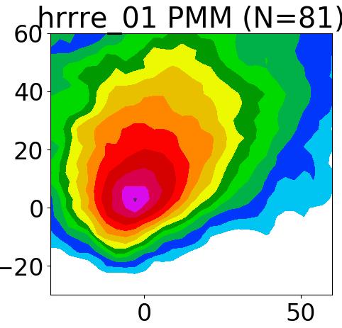

22 Prob Matched Mean composite dbz (preliminary) MRMS OU (NMMB) HRRRE (ARW) FV3-GFDL
23 Surrogate Severe: ARW vs FV3-G results for HWT 2017 Surrogate Severe Method: - Methods follow Sobash et al. papers - UH percentiles examined for fair comparisons - Used to calibrate model s UH climatology with observed severe weather reports each day. - NSSL-WRF 3km is clear winner - higher FSS and AUC - differences are significant

24 Major breakthrough in HWT: Use of storm-scale models to forecast severe weather ( ) Splitting storm Tornado Splitting storm Tornado or mesocyclone Numerical supercell simulations - 150m: Only possible in research setting m: Operational models in 5-10 years m: Current short-term forecast model Splitting storm Mesocyclone?????? m: Highest resolution ~ five years ago. - Storm scale models are a major shift from ingredientsbased forecasting.
 used to compared FV3- GFDL and 3-km NSSL-WRF - UH remapped to 80-km grid (24-h max in 80-km box) - A range of UH percentiles tested as severe weather surrogates.")
, 16 May Storm 2017 Severe with reports (FV3 weather left, overlaid.")
25 CLUE Results: FV3-GFDL (2017) Surrogate severe method (Sobash et al. 2011, 2016) used to compared FV3- GFDL and 3-km NSSL-WRF - UH remapped to 80-km grid (24-h max in 80-km box) - A range of UH percentiles tested as severe weather surrogates. Percentiles must be used because UH climatologies are very different! - To generate severe weather probabilities, a Gaussian with several σ tested. FV3-GFDL 3-km NSSL-WRF UH > 1000 m 2 s -2 - Example: Severe weather 24 h maximum probs (p=95%, UH for σ=75km), 16 May Storm 2017 Severe with reports (FV3 weather left, overlaid. NSSL-WRF probs (p=95%, right) σ=75km) - Higher, more widespread, and noisier appearance Aggregate of Surrogate UH in FV3. Severe results MAX AUC MAX FSS FV NSSL


26 CLUE Results: FV3 (2017) Subjective results Example of subjective comparison plots used for rating CAM performance at convective scales. The left panel shows 24-h forecast of composite reflectivity of the FV3-GFDL, the middle panel shows the 24-h forecast of composite reflectivity of the FV3-CAPS, and the right panel shows the observed composite reflectivity at 0000 UTC on 27 May Note the different character in simulated reflectivity left uses GFDL microphysics, right uses Thompson. According to SFE participant ratings, FV3 is competitive with operational CAMs 26

27 23 May 2017 TX Supercells (svr winds)
28 Challenges with FV3: NSSL Experiences Our senior computational scientist experience OAR funded project to be running NSSL-FV3 Global+CAM starting 1 Dec Many challenges inconsistent performance, resource issues, etc. GFDL package took about 4080 seconds on Jet; EMC package took about seconds on Jet; Hot off the PRESS: NSSL machine: EMC version: 4243 secs GFDL version: 3664 secs Knowledge base still confined to a few people Software not portable enough: must run on wide range of systems to leverage community Either NEMS + FV3 must be made workable on non-noaa systems or FV3 EMC core needs to be placed in a simpler framework Where does the global versus regional FV3 version fit in all of this?
 used for severe weather verification - UH remapped to 80-km grid - Severe weather probabilities derived")
 - For QPF, find obs rainfall threshold that gives same frequency as")


29 CLUE Results: Multi-core vs. Single core (2016) Surrogate severe (Sobash et al. 2011, 2016) used for severe weather verification - UH remapped to 80-km grid - Severe weather probabilities derived using different UH %iles and smoothing %iles and 53 σs tested (5300 sets of probs) - For QPF, find obs rainfall threshold that gives same frequency as severe weather (P = 2.71 inches). Surrogate severe max scores AUC FSS ARW NMMB Mixed-10mem Mixed-20mem Surrogate QPF max scores AUC FSS ARW NMMB Mixed-10mem Mixed-20mem Main results (will appear in a 2018 BAMS article) - Differences among subsets not significant - Multi-core slightly better than single core - 20 mems gives no added benefit QPF results AUC FSS Main QPF results - Single core equal or better than multi-core. - ARW significantly better than NMMB. - ARW rank histograms (bias-corrected) flatter than NMMB (better spread). 29
SPC Ensemble Applications: Current Status and Future Plans
 : Current Status and Future Plans Israel Jirak Science Support Branch Storm Prediction Center Norman, OK Acknowledgments: Steve Weiss, Andy Dean, Gregg Grosshans, and Chris Melick Outline Large-Scale Guidance:
Using Convection-Allowing Models to Produce Forecast Guidance For Severe Thunderstorm Hazards via a Surrogate-Severe Approach!
 Using Convection-Allowing Models to Produce Forecast Guidance For Severe Thunderstorm Hazards via a Surrogate-Severe Approach! Ryan Sobash! University of Oklahoma, School of Meteorology, Norman, OK! J.
Weather Hazard Modeling Research and development: Recent Advances and Plans
 Weather Hazard Modeling Research and development: Recent Advances and Plans Stephen S. Weygandt Curtis Alexander, Stan Benjamin, Geoff Manikin*, Tanya Smirnova, Ming Hu NOAA Earth System Research Laboratory
Development of High-Resolution Rapid Refresh (HRRR) Ensemble Data Assimilation, Forecasts and Post Processing
 Ensemble Data Assimilation, Forecasts and Post Processing") 7 th Ensemble Users Workshop Ensemble Development I Development of High-Resolution Rapid Refresh (HRRR) Ensemble Data Assimilation, Forecasts and Post Processing 14 June 2016 Curtis Alexander, David Dowell,
7 th Ensemble Users Workshop Ensemble Development I Development of High-Resolution Rapid Refresh (HRRR) Ensemble Data Assimilation, Forecasts and Post Processing 14 June 2016 Curtis Alexander, David Dowell,
Severe storm forecast guidance based on explicit identification of convective phenomena in WRF-model forecasts
 Severe storm forecast guidance based on explicit identification of convective phenomena in WRF-model forecasts Ryan Sobash 10 March 2010 M.S. Thesis Defense 1 Motivation When the SPC first started issuing
Extracting probabilistic severe weather guidance from convection-allowing model forecasts. Ryan Sobash 4 December 2009 Convection/NWP Seminar Series
 Extracting probabilistic severe weather guidance from convection-allowing model forecasts Ryan Sobash 4 December 2009 Convection/NWP Seminar Series Identification of severe convection in high-resolution
CAPS Storm-Scale Ensemble Forecasting (SSEF) System
 System") CAPS Storm-Scale Ensemble Forecasting (SSEF) System Fanyou Kong, Ming Xue, Xuguang Wang, Keith Brewster Center for Analysis and Prediction of Storms University of Oklahoma (collaborated with NSSL, SPC,
CAPS Storm-Scale Ensemble Forecasting (SSEF) System Fanyou Kong, Ming Xue, Xuguang Wang, Keith Brewster Center for Analysis and Prediction of Storms University of Oklahoma (collaborated with NSSL, SPC,
Chengsi Liu 1, Ming Xue 1, 2, Youngsun Jung 1, Lianglv Chen 3, Rong Kong 1 and Jingyao Luo 3 ISDA 2019
 Development of Optimized Radar Data Assimilation Capability within the Fully Coupled EnKF EnVar Hybrid System for Convective Permitting Ensemble Forecasting and Testing via NOAA Hazardous Weather Testbed
Development of High-Resolution Rapid Refresh (HRRR) Ensemble Data Assimilation, Forecast and Post-Processing
 Ensemble Data Assimilation, Forecast and Post-Processing") CORP Science Symposium, July 18-19, 2016, Fort Collins Development of High-Resolution Rapid Refresh (HRRR) Ensemble Data Assimilation, Forecast and Post-Processing Isidora Jankov, Curtis Alexander, David
CORP Science Symposium, July 18-19, 2016, Fort Collins Development of High-Resolution Rapid Refresh (HRRR) Ensemble Data Assimilation, Forecast and Post-Processing Isidora Jankov, Curtis Alexander, David
Report on EN6 DTC Ensemble Task 2014: Preliminary Configuration of North American Rapid Refresh Ensemble (NARRE)
") Report on EN6 DTC Ensemble Task 2014: Preliminary Configuration of North American Rapid Refresh Ensemble (NARRE) Motivation As an expansion of computing resources for operations at EMC is becoming available
Report on EN6 DTC Ensemble Task 2014: Preliminary Configuration of North American Rapid Refresh Ensemble (NARRE) Motivation As an expansion of computing resources for operations at EMC is becoming available
Introduction to NCEP's time lagged North American Rapid Refresh Ensemble Forecast System (NARRE-TL)
") Introduction to NCEP's time lagged North American Rapid Refresh Ensemble Forecast System (NARRE-TL) Binbin Zhou 1,2, Jun Du 2, Geoff Manikin 2 & Geoff DiMego 2 1. I.M. System Group 2. EMC/NCEP/NWS/NOAA
Introduction to NCEP's time lagged North American Rapid Refresh Ensemble Forecast System (NARRE-TL) Binbin Zhou 1,2, Jun Du 2, Geoff Manikin 2 & Geoff DiMego 2 1. I.M. System Group 2. EMC/NCEP/NWS/NOAA
Verifying Ensemble Forecasts Using A Neighborhood Approach
 Verifying Ensemble Forecasts Using A Neighborhood Approach Craig Schwartz NCAR/MMM schwartz@ucar.edu Thanks to: Jack Kain, Ming Xue, Steve Weiss Theory, Motivation, and Review Traditional Deterministic
Canadian Meteorological and Oceanographic Society and American Meteorological Society 21 st Conference on Numerical Weather Prediction 31 May 2012
 Canadian Meteorological and Oceanographic Society and American Meteorological Society 21 st Conference on Numerical Weather Prediction 31 May 2012 The High Resolution Rapid Refresh (): An hourly updating
A Look at the NSSL-WRF Forecast Output for the Violent Tornado Events in Central Oklahoma on May 19 and 20, 2013
 A Look at the NSSL-WRF Forecast Output for the Violent Tornado Events in Central Oklahoma on May 19 and 20, 2013 David A. Imy, NOAA SPC, emeritus and Adam J. Clark, CIMMS/NSSL, Norman, OK 1. Introduction
A Cycled GSI+EnKF and Storm-Scale Ensemble Forecasting (SSEF) Experiment
 Experiment") A Cycled GSI+EnKF and Storm-Scale Ensemble Forecasting (SSEF) Experiment Fanyou Kong, Ming Xue, Youngsun Jung, Keith A. Brewster, Gang Zhao Center for Analysis and Prediction of Storms University of Oklahoma
A Cycled GSI+EnKF and Storm-Scale Ensemble Forecasting (SSEF) Experiment Fanyou Kong, Ming Xue, Youngsun Jung, Keith A. Brewster, Gang Zhao Center for Analysis and Prediction of Storms University of Oklahoma
Convection-Permitting Ensemble Forecasts at CAPS for Hazardous Weather Testbed (HWT)
") Convection-Permitting Ensemble Forecasts at CAPS for Hazardous Weather Testbed (HWT) Ming Xue Center for Analysis and Prediction of Storms and School of Meteorology University of Oklahoma mxue@ou.edu August,
Convection-Permitting Ensemble Forecasts at CAPS for Hazardous Weather Testbed (HWT) Ming Xue Center for Analysis and Prediction of Storms and School of Meteorology University of Oklahoma mxue@ou.edu August,
2012 and changes to the Rapid Refresh and HRRR weather forecast models
 2012 and 2013-15 changes to the Rapid Refresh and HRRR weather forecast models 31 October 2012 Stan Benjamin Steve Weygandt Curtis Alexander NOAA Earth System Research Laboratory Boulder, CO FPAW - 2012
NOAA s Severe Weather Forecasting System: HRRR to WoF to FACETS
 NOAA s Severe Weather Forecasting System: HRRR to WoF to FACETS David D NOAA / Earth System Research Laboratory / Global Systems Division Nowcasting and Mesoscale Research Working Group Meeting World Meteorological
Development of an Hourly- Updated NAM Forecast System
 Development of an Hourly- Updated NAM Forecast System Jacob Carley ab, Eric Rogers b, Shun Liu ab, Brad Ferrier ab, Eric Aligo ab, Matthew Pyle b, and Geoff DiMego b a IMSG, b NOAA/NWS/NCEP/EMC jacob.carley@noaa.gov
VERIFICATION OF PROXY STORM REPORTS DERIVED FROM ENSEMBLE UPDRAFT HELICITY
 VERIFICATION OF PROXY STORM REPORTS DERIVED FROM ENSEMBLE UPDRAFT HELICITY MALLORY ROW 12,JAMES CORRIEA JR. 3, AND PATRICK MARSH 3 1 National Weather Center Research Experiences for Undergraduates Program
weather forecast Improving NOAA models for energy Stan Benjamin, Boulder, CO USA Joseph Olson, Curtis Alexander, Eric James,
 Lamont, OK X Obs radar 5h HRRR Forecast Improving NOAA weather forecast models for energy Stan Benjamin, Joseph Olson, Curtis Alexander, Eric James, Dave Turner, Melinda Marquis NOAA Earth System Research
Plans for NOAA s regional ensemble systems: NARRE, HRRRE, and a regional hybrid assimilation
 NOAA Earth System Research Laboratory Plans for NOAA s regional ensemble systems: NARRE, HRRRE, and a regional hybrid assimilation Tom Hamill (substituting for Stan Benjamin and team) NOAA Earth System
New Development in CAPS Storm-Scale Ensemble Forecasting System for NOAA 2012 HWT Spring Experiment
 New Development in CAPS Storm-Scale Ensemble Forecasting System for NOAA 2012 HWT Spring Experiment Fanyou Kong, Ming Xue, Kevin W. Thomas, Yunheng Wang, Keith Brewster, Xuguang Wang (Center for Analysis
IMPACT OF DIFFERENT MICROPHYSICS SCHEMES AND ADDITIONAL SURFACE OBSERVATIONS ON NEWS-E FORECASTS
 IMPACT OF DIFFERENT MICROPHYSICS SCHEMES AND ADDITIONAL SURFACE OBSERVATIONS ON NEWS-E FORECASTS Francesca M. Lappin 1, Dustan M. Wheatley 2,3, Kent H. Knopfmeier 2,3, and Patrick S. Skinner 2,3 1 National
CAPS Storm-Scale Ensemble Forecast for the NOAA Hazardous Weather Testbed (HWT) Spring Experiment
 Spring Experiment") CAPS Storm-Scale Ensemble Forecast for the NOAA Hazardous Weather Testbed (HWT) Spring Experiment Fanyou Kong, Ming Xue, Kevin W. Thomas, Yunheng Wang, Keith Brewster, Xuguang Wang (Center for Analysis
CAPS Storm-Scale Ensemble Forecast for the NOAA Hazardous Weather Testbed (HWT) Spring Experiment Fanyou Kong, Ming Xue, Kevin W. Thomas, Yunheng Wang, Keith Brewster, Xuguang Wang (Center for Analysis
46 AN OVERVIEW OF THE 2014 NOAA HAZARDOUS WEATHER TESTBED SPRING FORECASTING EXPERIMENT
 46 AN OVERVIEW OF THE 2014 NOAA HAZARDOUS WEATHER TESTBED SPRING FORECASTING EXPERIMENT Israel L. Jirak 1*, Michael Coniglio 2, Adam J. Clark 2,3, James Correia Jr. 1,3, Kent H. Knopfmeier 2,3, Christopher
Comparison of Convection-permitting and Convection-parameterizing Ensembles
 Comparison of Convection-permitting and Convection-parameterizing Ensembles Adam J. Clark NOAA/NSSL 18 August 2010 DTC Ensemble Testbed (DET) Workshop Introduction/Motivation CAMs could lead to big improvements
Center for Analysis and Prediction of Storms 1 and School of Meteorology 2 University of Oklahoma, Norman, OK 73072
 Evaluation of Convection-Permitting Precipitation Forecast Products using WRF, NMMB, and FV3 for the 2016-2017 NOAA Hydrometeorology Testbed Flash Flood and Intense Rainfall Experiments Nathan Snook 1,
ENSEMBLE FORECASTS AND VERIFICATION OF THE MAY 2015 MULTI-HAZARD SEVERE WEATHER EVENT IN OKLAHOMA. Austin Coleman 1, Nusrat Yussouf 2
 ENSEMBLE FORECASTS AND VERIFICATION OF THE MAY 2015 MULTI-HAZARD SEVERE WEATHER EVENT IN OKLAHOMA Austin Coleman 1, Nusrat Yussouf 2 1 National Weather Center Research Experience for Undergraduates Program,
Thunderstorm-Scale EnKF Analyses Verified with Dual-Polarization, Dual-Doppler Radar Data
 Thunderstorm-Scale EnKF Analyses Verified with Dual-Polarization, Dual-Doppler Radar Data David Dowell and Wiebke Deierling National Center for Atmospheric Research, Boulder, CO Ensemble Data Assimilation
1. INTRODUCTION 3. PROJECT DATAFLOW
 P10.5 THE NOAA HAZARDOUS WEATHER TESTBED 2008 SPRING EXPERIMENT: TECHINCAL AND SCIENTIFIC CHALLENGES OF CREATING A DATA VISUALIZATION ENVIRONMENT FOR STORM- SCALE DETERMINISTIC AND ENSEMBLE FORECASTS Jason
Variable-Resoluiton Global Atmospheric Modeling Spanning Convective to Planetary Scales
 Variable-Resoluiton Global Atmospheric Modeling Spanning Convective to Planetary Scales Bill Skamarock, NCAR/MMM MPAS consists of geophysical fluid-flow solvers based on unstructured centroidal Voronoi
Convection-Resolving NWP with WRF. Section coordinator Ming Xue University of Oklahoma
 Convection-Resolving NWP with WRF Section coordinator Ming Xue University of Oklahoma Convection-resolving NWP Is NWP that explicitly treats moist convective systems ranging from organized MCSs to individual
Developmental Testbed Center Visitor Program Final Report: Development and Application of 3-Dimensional Object Algorithms to High Resolution Forecasts
 Developmental Testbed Center Visitor Program Final Report: Development and Application of 3-Dimensional Object Algorithms to High Resolution Forecasts Adam J. Clark Cooperative Institute for Mesoscale
University of Oklahoma, Norman, OK INTRODUCTION
 Preprints, 22th Conf. on Weather Analysis and Forecasting and 18th Conf. on Numerical Weather Prediction Amer. Meteor. Soc., Park City, UT, 25-29 June 2007 3B.2 PRELIMINARY ANALYSIS ON THE REAL-TIME STORM-SCALE
HMON (HNMMB): Development of a new Hurricane model for NWS/NCEP operations
: Development of a new Hurricane model for NWS/NCEP operations") 1 HMON (HNMMB): Development of a new Hurricane model for NWS/NCEP operations Avichal Mehra, EMC Hurricane and Mesoscale Teams Environmental Modeling Center NOAA / NWS / NCEP HMON: A New Operational Hurricane
1 HMON (HNMMB): Development of a new Hurricane model for NWS/NCEP operations Avichal Mehra, EMC Hurricane and Mesoscale Teams Environmental Modeling Center NOAA / NWS / NCEP HMON: A New Operational Hurricane
J11.1 AN OVERVIEW OF THE 2013 NOAA HAZARDOUS WEATHER TESTBED SPRING FORECASTING EXPERIMENT
 J11.1 AN OVERVIEW OF THE 2013 NOAA HAZARDOUS WEATHER TESTBED SPRING FORECASTING EXPERIMENT Israel L. Jirak 1*, Michael Coniglio 2, Adam J. Clark 2,3, James Correia Jr. 1,3, Kent H. Knopfmeier 2,3, Christopher
THE DECORRELATION SCALE: METHODOLOGY AND APPLICATION FOR PRECIPITATION FORECASTS
 THE DECORRELATION SCALE: METHODOLOGY AND APPLICATION FOR PRECIPITATION FORECASTS Madalina Surcel, Isztar Zawadzki and M. K. Yau Thanking Adam Clark (NSSL), Ming Xue (OU, CAPS) and Fanyou Kong (CAPS) for
HFIP Annual Review Meeting November 5-7, 2018 Embassy Suites by Hilton Miami International Airport 3974 NW S River Dr, Miami, FL 33142
 HFIP Annual Review Meeting November 5-7, 2018 Embassy Suites by Hilton Miami International Airport 3974 NW S River Dr, Miami, FL 33142 Overall Objectives The new HFIP Strategic Plan detailing the specific
Deterministic and Ensemble Storm scale Lightning Data Assimilation
 LI Mission Advisory Group & GOES-R Science Team Workshop 27-29 May 2015 Deterministic and Ensemble Storm scale Lightning Data Assimilation Don MacGorman, Ted Mansell (NOAA/National Severe Storms Lab) Alex
4.5 A WRF-DART study of the nontornadic and tornadic supercells intercepted by VORTEX2 on 10 June 2010
 4.5 A WRF-DART study of the nontornadic and tornadic supercells intercepted by VORTEX2 on 10 June 2010 ALICIA M. KLEES AND YVETTE P. RICHARDSON The Pennsylvania State University, University Park, Pennsylvania.
The Long-lived eastern US tornadic supercell of 20 July 2017
 1. Overview The Long-lived eastern US tornadic supercell of 20 July 2017 By Richard H. Grumm and Elissa A Smith National Weather Service State College, PA A long lived supercell developed near the eastern
Convective-scale Warn-on-Forecast The Future of Severe Weather Warnings in the USA?
 Convective-scale Warn-on-Forecast The Future of Severe Weather Warnings in the USA? David J. Stensrud Department of Meteorology The Pennsylvania State University Present Warning System: 2 March 2012 Warning
FAA Weather Research Plans
 FAA Weather Research Plans Presented to: Friends /Partners in Aviation Weather Vision Forum By: Ray Moy FAA Aviation Weather Office Date: Aviation Weather Research Program (AWRP) Purpose: Applied Research
Verification of ensemble and probability forecasts
 Verification of ensemble and probability forecasts Barbara Brown NCAR, USA bgb@ucar.edu Collaborators: Tara Jensen (NCAR), Eric Gilleland (NCAR), Ed Tollerud (NOAA/ESRL), Beth Ebert (CAWCR), Laurence Wilson
Nowcasting techniques in use for severe weather operation in NMC/CMA
 WWRP NMRWG Buenos Aires Aug 2017 Nowcasting techniques in use for severe weather operation in NMC/CMA Jianjie WANG National Meteorological Center, CMA Cascading Weather Forecasting Process --- different
The role of testbeds in NOAA for transitioning NWP research to operations
 ECMWF Workshop on Operational Systems November 18, 2013 The role of testbeds in NOAA for transitioning NWP research to operations Ligia Bernardet 1* and Zoltan Toth 1 1 NOAA ESRL Global Systems Division,
14B.1 Evaluating cloud microphysics schemes in nested NMMB forecasts
 14B.1 Evaluating cloud microphysics schemes in nested NMMB forecasts Brad Ferrier1,2 Weiguo Wang1,2 Edward Colón1,2 NOAA/NWS/NCEP Environmental Modeling Center (EMC) 2 IM Systems Group, Inc. (IMSG) 1 1
HPC Ensemble Uses and Needs
 1 HPC Ensemble Uses and Needs David Novak Science and Operations Officer With contributions from Keith Brill, Mike Bodner, Tony Fracasso, Mike Eckert, Dan Petersen, Marty Rausch, Mike Schichtel, Kenneth
Verification as Diagnosis: Performance Diagrams for Numerical Forecasts of Severe Precipitation in California during the HMT Winter Exercises
 Verification as Diagnosis: Performance Diagrams for Numerical Forecasts of Severe Precipitation in California during the HMT Winter Exercises Edward Tollerud 1,2, Barbara Brown 1,3, Tara Jensen 1,3, John
2010 CAPS Spring Forecast Experiment Program Plan (A Brief Version)
") 21 CAPS Spring Forecast Experiment Program Plan (A Brief Version) May 17, 21 Table of Content Table of Content... 2 1. Overview of New Features for 21 Season... 3 2. Program Duration... 4 3. Forecast System
21 CAPS Spring Forecast Experiment Program Plan (A Brief Version) May 17, 21 Table of Content Table of Content... 2 1. Overview of New Features for 21 Season... 3 2. Program Duration... 4 3. Forecast System
Applications in situational awareness high-resolution NWP -- Ideas for the Blueprint DA discussion
 Applications in situational awareness high-resolution NWP -- Ideas for the Blueprint DA discussion 8 March 2016 Stan Benjamin, David Dowell, Curtis Alexander NOAA/ESRL/GLOBAL SYSTEMS DIVISION Situational
NOAA Update. SPARC DA and S-RIP Workshop October 17-21, 2016 Victoria, BC
 NOAA Update Craig S. Long Bill Lapenta, Hendrik Tolman, Wesley Ebisuzaki, Leigh Zhang, Hyun-Chul Lee, Jack Woolen, Jeff Whitaker NOAA/NWS/NCEP and NOAA/OAR/ESRL Topics Recent Upgrades NCEP Production Suite
Update on CoSPA Storm Forecasts
 Update on CoSPA Storm Forecasts Haig August 2, 2011 This work was sponsored by the Federal Aviation Administration under Air Force Contract No. FA8721-05-C-0002. Opinions, interpretations, conclusions,
Panel Session 8: Current Capabilities and Future Plans for Surface Transportation Weather Support
 Panel Session 8: Current Capabilities and Future Plans for Surface Transportation Weather Support Andrew Stern Chief Operations Officer, OCWWS NOAA/ AMS Washington Forum, April 3, 2014 Weather-related
A COMPREHENSIVE 5-YEAR SEVERE STORM ENVIRONMENT CLIMATOLOGY FOR THE CONTINENTAL UNITED STATES 3. RESULTS
 16A.4 A COMPREHENSIVE 5-YEAR SEVERE STORM ENVIRONMENT CLIMATOLOGY FOR THE CONTINENTAL UNITED STATES Russell S. Schneider 1 and Andrew R. Dean 1,2 1 DOC/NOAA/NWS/NCEP Storm Prediction Center 2 OU-NOAA Cooperative
NOAA Research and Development Supporting NextGen. Darien Davis NOAA Office of Oceanic and Atmospheric Research June 22, 2009
 NOAA Research and Development Supporting NextGen Darien Davis Darien.l.davis@noaa.gov NOAA Office of Oceanic and Atmospheric Research June 22, 2009 FAA/NOAA Coordination Developing an integrated science
P1.10 Synchronization of Multiple Radar Observations in 3-D Radar Mosaic
 Submitted for the 12 th Conf. on Aviation, Range, and Aerospace Meteor. 29 Jan. 2 Feb. 2006. Atlanta, GA. P1.10 Synchronization of Multiple Radar Observations in 3-D Radar Mosaic Hongping Yang 1, Jian
10.3 PROBABILISTIC FORECASTS OF LOCATION AND TIMING OF CONVECTION DURING THE 2012 NOAA HAZARDOUS WEATHER TESTBED SPRING FORECASTING EXPERIMENT
 10.3 PROBABILISTIC FORECASTS OF LOCATION AND TIMING OF CONVECTION DURING THE 2012 NOAA HAZARDOUS WEATHER TESTBED SPRING FORECASTING EXPERIMENT Stuart D. Miller, Jr.*,3,4,6, John S. Kain 1, Patrick T. Marsh
INTRODUCTION HAZARDOUS CONVECTIVE WEATHER (HCW)
") CLIMATE CHANGE AND HAZARDOUS CONVECTIVE WEATHER IN THE UNITED STATES: INSIGHT FROM HIGH-RESOLUTION DYNAMICAL DOWNSCALING GEWEX WORKSHOP Kimberly Hoogewind 1,2, Jeff Trapp 2, and Mike Baldwin 1 1 Purdue
CLIMATE CHANGE AND HAZARDOUS CONVECTIVE WEATHER IN THE UNITED STATES: INSIGHT FROM HIGH-RESOLUTION DYNAMICAL DOWNSCALING GEWEX WORKSHOP Kimberly Hoogewind 1,2, Jeff Trapp 2, and Mike Baldwin 1 1 Purdue
Short-term Forecasts of Left-Moving Supercells from an Experimental Warn-on-Forecast System
 Jones, T. A., and C. Nixon, 2017: Short-term forecasts of left-moving supercells from an experimental Warn-on-Forecast system. J. Operational Meteor., 5 (13), 161-170, doi: https://doi.org/10.15191/nwajom.2017.0513
Ensemble Kalman Filter Assimilation of Radar Data for a Convective Storm using a Two-moment Microphysics Scheme 04/09/10
 Ensemble Kalman Filter Assimilation of Radar Data for a Convective Storm using a Two-moment Microphysics Scheme 04/09/10 Youngsun Jung 1, Ming Xue 1,2, and Mingjing Tong 3 CAPS 1 and School of Meteorology
Severe Weather with a strong cold front: 2-3 April 2006 By Richard H. Grumm National Weather Service Office State College, PA 16803
 Severe Weather with a strong cold front: 2-3 April 2006 By Richard H. Grumm National Weather Service Office State College, PA 16803 1. INTRODUCTION A strong cold front brought severe weather to much of
The Impact of Horizontal Resolution and Ensemble Size on Probabilistic Forecasts of Precipitation by the ECMWF EPS
 The Impact of Horizontal Resolution and Ensemble Size on Probabilistic Forecasts of Precipitation by the ECMWF EPS S. L. Mullen Univ. of Arizona R. Buizza ECMWF University of Wisconsin Predictability Workshop,
Moving to a simpler NCEP production suite
 Moving to a simpler NCEP production suite Unified coupled global modeling Hendrik L. Tolman Director, Environmental Modeling Center NOAA / NWS / NCEP Hendrik.Tolman@NOAA.gov page 1 of 14 Content The suite
1. INTRODUCTION 2. QPF
 440 24th Weather and Forecasting/20th Numerical Weather Prediction HUMAN IMPROVEMENT TO NUMERICAL WEATHER PREDICTION AT THE HYDROMETEOROLOGICAL PREDICTION CENTER David R. Novak, Chris Bailey, Keith Brill,
Unifying the NCEP Production Suite
 Unifying the NCEP Production Suite Integrated coupled modelling approach at NCEP Michael B. Ek Deputy Director, Environmental Modeling Center (EMC) National Centers for Environmental Prediction (NCEP)
The WRF Developmental Testbed Center (DTC)
") The WRF Developmental Testbed Center (DTC) Bob Gall A facility where the NWP research and operational communities interact to accelerate testing and evaluation of new models and techniques for research
The WRF Developmental Testbed Center (DTC) Bob Gall A facility where the NWP research and operational communities interact to accelerate testing and evaluation of new models and techniques for research
The NOAA Operational Numerical Guidance System: Recent Changes and Moving Forward. William. M. Lapenta Acting Director Environmental Modeling Center
 AMS Future of the Weather Enterprise 11/27/12 1 N C E P The NOAA Operational Numerical Guidance System: Recent Changes and Moving Forward William. M. Lapenta Acting Director Environmental Modeling Center
Blend of UKMET and GFS 3hr increments F06 to F degree downloadable grid available on WIFS
 Blend of UKMET and GFS 3hr increments F06 to F36 1.25 degree downloadable grid available on WIFS WWW.AVIATIONWEATHER.GOV/WAFS Wind, Turbulence and Cb 2 3 New Products: All diagnostics mapped to Eddy Dissipation
Amy Harless. Jason Levit, David Bright, Clinton Wallace, Bob Maxson. Aviation Weather Center Kansas City, MO
 Amy Harless Jason Levit, David Bright, Clinton Wallace, Bob Maxson Aviation Weather Center Kansas City, MO AWC Mission Decision Support for Traffic Flow Management Ensemble Applications at AWC Testbed
Assimilation of radar reflectivity
 Assimilation of radar reflectivity Axel Seifert Deutscher Wetterdienst, Offenbach, Germany Convective-scale NWP at DWD: Plans for 2020 Storm-scale ICON-RUC-EPS: hourly 12h ensemble forecasts based on short
NOAA s Hurricane Forecast Improvement Project: Framework for Addressing the Weather Research Forecasting Innovation Act of 2017
 NOAA s Hurricane Forecast Improvement Project: Framework for Addressing the Weather Research Forecasting Innovation Act of 2017 Frank Marks (NOAA/AOML/HRD) November 7, 2018 NOAA Hurricane Forecast Improvement
HRRR and the Mid-Mississippi Valley Severe and Heavy rainfall event of October 2014
 HRRR and the Mid-Mississippi Valley Severe and Heavy rainfall event of 13-14 October 2014 By Richard H. Grumm National Weather Service State College, PA contributions by Charles Ross 1. Overview A deep
Variable-resolution weather and climate modeling with GFDL FV3
 Variable-resolution weather and climate modeling with GFDL FV3 Lucas Harris for S-J Lin and the GFDL FV3 Team 18th Workshop on high-performance computing in Meteorology ECMWF, Reading, UK 26 September
The National Weather Service of the Future: Building a Weather-Ready Nation
 The of the Future: Building a Weather-Ready Nation Dr. Louis W. Uccellini Director, NOAA Assistant Administrator for Weather Services NCEP Production Suite Review December 2, 2014 Outline Building a Weather-Ready
The EMC Mission.. In response to operational requirements:
 The EMC Mission.. In response to operational requirements: Maintain operational model suite The scientific correctness and integrity of operational forecast modeling systems Modify current operational
A 21st century HRRR-based approach to estimating probable maximum precipitation to enhance dam safety and community resilience
 30 May 2017 FIRO Science Task Group Workshop A 21st century HRRR-based approach to estimating probable maximum precipitation to enhance dam safety and community resilience Courtesy Bill McCormick, Chief,
Interstate Data Moving and the Last Block Problem: Lessons Learned in the CAPS Spring Experiment 2014
 Interstate Data Moving and the Last Block Problem: Lessons Learned in the CAPS Spring Experiment 2014 Keith A. Brewster, Ph.D. Center for Analysis and Prediction of Storms University of Oklahoma SPC/NSSL
Motivation & Goal. We investigate a way to generate PDFs from a single deterministic run
 Motivation & Goal Numerical weather prediction is limited by errors in initial conditions, model imperfections, and nonlinearity. Ensembles of an NWP model provide forecast probability density functions
High Resolution Numerical Weather Prediction for High Impact and Extreme Weather Events in 2014 across Southern California
 High Resolution Numerical Weather Prediction for High Impact and Extreme Weather Events in 2014 across Southern California Alex Tardy Alexander.Tardy@noaa.gov NWS San Diego Warning Coordination Meteorologist
Background. Each spring during the climatological. An Overview of the Experimental Forecast
 An Overview of the 2010 Hazardous Weather Testbed Experimental Forecast Program Spring Experiment by Ad a m J. Cl a r k, St e v e n J. Weiss, Joh n S. Ka i n, Is r a e l L. Ji r a k, Mi c h a e l Co n
Using the LEAD Portal for Customized Weather Forecasts on the TeraGrid
 Using the LEAD Portal for Customized Weather Forecasts on the TeraGrid Keith Brewster Center for Analysis and Prediction of Storms, Univ. of Oklahoma Dan Weber, Suresh Marru, Kevin Thomas, Dennis Gannon,
Tornado-Resolving Ensemble and Probabilistic Predictions of the 20 May 2013 Newcastle-Moore EF5 Tornado
 Tornado-Resolving Ensemble and Probabilistic Predictions of the 20 May 2013 Newcastle-Moore EF5 Tornado Nathan Snook 1, Ming Xue 1,2, and Youngsun Jung 1 Center for Analysis and Prediction of Storms 1
Development and Research of GSI- based Var/EnKF/EnVar/ Hybrid System to Assimilate Radar ObservaBons for ConvecBve Scale NWP
 Development and Research of GSI- based Var/EnKF/EnVar/ Hybrid System to Assimilate Radar ObservaBons for ConvecBve Scale NWP Xuguang Wang School of Meteorology University of Oklahoma, Norman, OK D Acknowledgement
AMPS Update June 2016
 AMPS Update June 2016 Kevin W. Manning Jordan G. Powers Mesoscale and Microscale Meteorology Laboratory National Center for Atmospheric Research Boulder, CO 11 th Antarctic Meteorological Observation,
Climatology of storm reports as a function of jet streak quadrant and system morphology
 Climatology of storm reports as a function of jet streak quadrant and system morphology William A. Gallus, Jr. Iowa State University (contributors include Adam Clark, Chris Schaffer, Kaj O Mara and Jeff
32 AN OVERVIEW OF CAPS STORMSCALE ENSEMBLE FORECAST FOR THE 2015 NOAA HWT SPRING FORECASTING EXPERIMENT
 !"# #$%#&'(&#)*+ 32 AN OVERVIEW OF CAPS STORMSCALE ENSEMBLE FORECAST FOR THE 2015 NOAA HWT SPRING FORECASTING EXPERIMENT Fanyou Kong 1 *, Ming Xue 1,2, Youngsun Jung 1, Keith A. Brewster 1, Kevin W. Thomas
A new mesoscale NWP system for Australia
 A new mesoscale NWP system for Australia www.cawcr.gov.au Peter Steinle on behalf of : Earth System Modelling (ESM) and Weather&Environmental Prediction (WEP) Research Programs, CAWCR Data Assimilation
Report on EN2 DTC Ensemble Task 2015: Testing of Stochastic Physics for use in NARRE
 Report on EN2 DTC Ensemble Task 2015: Testing of Stochastic Physics for use in NARRE Motivation: With growing evidence that initial- condition uncertainties are not sufficient to entirely explain forecast
457 EVALUATION OF CAPS MULTI-MODEL STORM-SCALE ENSEMBLE FORECAST FOR THE NOAA HWT 2010 SPRING EXPERIMENT
 24th Conference on Weather and Forecasting/20th Conference on Numerical Weather Prediction. AMS, Seattle, WA, January 23-27, 2011. 457 EVALUATION OF CAPS MULTI-MODEL STORM-SCALE ENSEMBLE FORECAST FOR THE
Welcome to the 5 th NCEP Ensemble Users Workshop William. M. Lapenta Acting Director Environmental Modeling Center NOAA/NWS/NCEP
 N C E P Welcome to the 5 th NCEP Ensemble Users Workshop William. M. Lapenta Acting Director Environmental Modeling Center NOAA/NWS/NCEP The National Centers for Environmental Prediction CPC NHC NCO HPC
Multi Radar Multi Sensor NextGen Weather Program. Presentation materials sourced from: Ken Howard HydroMet Research Group NSSL Warning R&D Division
 Multi Radar Multi Sensor NextGen Weather Program Presentation materials sourced from: Ken Howard HydroMet Research Group NSSL Warning R&D Division What is Multiple Radar Multi Sensor System () is the world
Development and Research of GSI-based EnVar System to Assimilate Radar Observations for Convective Scale Analysis and Forecast
 Development and Research of GSI-based EnVar System to Assimilate Radar Observations for Convective Scale Analysis and Forecast Xuguang Wang, Yongming Wang School of Meteorology University of Oklahoma,
Climate Forecast System (CFS) Preliminary review of 2015 CFS anomaly forecasts of precipitation and severe weather Greg Carbin, NOAA/NWS/SPC
 Preliminary review of 2015 CFS anomaly forecasts of precipitation and severe weather Greg Carbin, NOAA/NWS/SPC") Climate Forecast System (CFS) Preliminary review of 2015 CFS anomaly forecasts of precipitation and severe weather Greg Carbin, NOAA/NWS/SPC Climate Forecast System (CFS) Severe 2015-16 Updates Dashboard
Climate Forecast System (CFS) Preliminary review of 2015 CFS anomaly forecasts of precipitation and severe weather Greg Carbin, NOAA/NWS/SPC Climate Forecast System (CFS) Severe 2015-16 Updates Dashboard
Linking the Hydrologic and Atmospheric Communities Through Probabilistic Flash Flood Forecasting
 Linking the Hydrologic and Atmospheric Communities Through Probabilistic Flash Flood Forecasting Wallace Hogsett Science and Operations Officer NOAA/NWS/Weather Prediction Center with numerous contributions
Evaluation of Ensemble Icing Probability Forecasts in NCEP s SREF, VSREF and NARRE-TL Systems
 Evaluation of Ensemble Icing Probability Forecasts in NCEP s, V and Systems Binbin Zhou 1,2, Jun Du 2, Geoff DeMigo 2 and Robert Sallee 3 1. I.M. System Group 2. Environmental Modeling Center of NCEP 3.
11.1 CONVECTION FORECASTS FROM THE HOURLY UPDATED, 3-KM HIGH RESOLUTION RAPID REFRESH (HRRR) MODEL
 MODEL") Preprints, 24 th Conference on Severe Local Storms, October 2008, Savannah, GA, Amer. Meteor. Soc. 11.1 CONVECTION FORECASTS FROM THE HOURLY UPDATED, 3-KM HIGH RESOLUTION RAPID REFRESH (HRRR) MODEL Tracy
Preprints, 24 th Conference on Severe Local Storms, October 2008, Savannah, GA, Amer. Meteor. Soc. 11.1 CONVECTION FORECASTS FROM THE HOURLY UPDATED, 3-KM HIGH RESOLUTION RAPID REFRESH (HRRR) MODEL Tracy
Some Applications of WRF/DART
 Some Applications of WRF/DART Chris Snyder, National Center for Atmospheric Research Mesoscale and Microscale Meteorology Division (MMM), and Institue for Mathematics Applied to Geoscience (IMAGe) WRF/DART
Evaluation of WRF Model Output for Severe Weather Forecasting from the 2008 NOAA Hazardous Weather Testbed Spring Experiment
 408 W E A T H E R A N D F O R E C A S T I N G VOLUME 25 Evaluation of WRF Model Output for Severe Weather Forecasting from the 2008 NOAA Hazardous Weather Testbed Spring Experiment MICHAEL C. CONIGLIO,