Transport Systems and Public Health: the Case of Traffic Congestion
|
|
|
- Derek Ray
- 5 years ago
- Views:
Transcription
1 Transport Systems and Public Health: the Case of Traffic Congestion Ghassan Abu-Lebdeh, Ph.D. Assoc. Prof., Civil Engineering American Univ. of Sharjah, Sharjah, UAE Visiting Scholar University of Washington, Seattle, USA UNSW Nov. 25, 2014

2

3 Transport Systems: the good Key to economic health Integral to social wellbeing Strategic/national defense A public health component Increased physical activity Improved nutrition Decreased occurrence of specific health issues: diabetes, stroke, obesity, Other


4 Transport Systems: the not-so-good Report: World Health Organization (WHO)

5


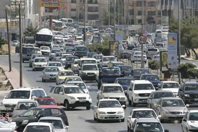
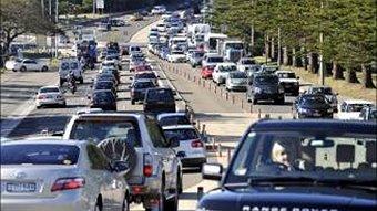
6

7
8

9 What is Health? a state of complete physical, mental and social well-being and not merely the absence of disease or infirmity Physical health Mental health Well-being Livability World Health Organization
10 How Does Transportation Affect Health? Physical activity and obesity Air pollution and asthma Motor vehicle crashes and pedestrian injuries Other impacts Water quality Climate change Mental health Physical health Noise Social capital Environmental justice
11 Factors that Affect Health Smallest Impact Education Clinical Interventions Largest Impact Long-lasting Protective Interventions Changing the Context to make individuals default decisions healthy: BUILT ENVIRONMENT Socio-Economic Factors (Frieden, AJPH, 100:590, 2010)

12


13 Traffic Congestion Economic, productivity problem Environmental challenge A stressor A public health issue

14

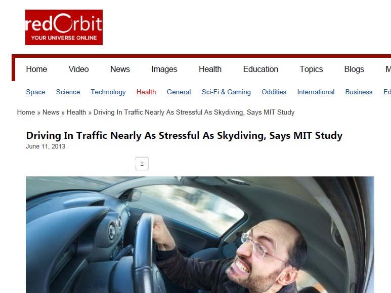
15 Traffic vs other stressors


16 Congestion is a stressor Psychological/physiological stress Stressors can be health issues regardless of trigger
17 Effects of Congestion on Mental Health and Wellbeing regular exposure to traffic congestion impairs health, psychological adjustment, work performance and overall satisfaction with life Congestion constrains movement, which increases blood pressure and frustration tolerance. (WHO, 2000) Long term physiological impairment
18 The Ecology of Commuting Stress TRANSP. ENVIRON. Commuting/Regional Travel Conditions Personal Commuting Situation HOME DOMAIN Stressors Resources COMMUTING DOMAIN Physical Impedance Other Travel Stressors Resources WORK DOMAIN Stressors Resources Subjective Impedance COPING Cognitive Behavioral (Novako, Stokols, Melanesi, 1990) STRESS OUTCOMES Health, Behavioral, Family, Organizational
19 Acute vs. Chronic Stress Which is worse? Traffic stress is chronic It is the little thing that matters
20 Sources of Stress in Traffic (literature) 1. Stuck in traffic or start-stop driving associated with congestion 2. Caught in traffic flow, can only join in 3. Brake hard for various reasons 4. Intense info/maneuvers/decisions 5. Physical & perceived impedance 6. Lack of information: why; how long, how far? 7. No big picture; no system view 8. Unpredictability 9. Impatient/aggressive driving by others 10. Pressured to drive faster by vehicles following 11. Other.


21 The Question Can we eliminate/reduce/lessen these sources of stress through carefully designed control? Yes/No?

22 New Control Dynamic signal control & Dynamic speed control Change signal control and speed dynamically Communicate link speed to drivers

23 Control schematics Repeat over time 23


24 A closer look


25 Objective Function Max. ( ( Max. ( - (
26 Constraints min g g(, i j) k max g, for ( i, j) N( ny, nx), k = 1, 2,... n min ds ds(, i j) k max ds, for ( i, j) N( ny, nx), k = 1,2,... n q are known; ( i, j) 1 for ( i, j) N( ny, nx), k = 1,2,... n q(, i j) k max q ; for ( i, j) N( ny, nx), k = 1,2,... n av (, lmk ) = dv(, i jk ), for ( i, j),( l, m) N( ny, nx), k = 1, 2,... n and (i, j) is the immediate upstream signal of (l, m) dv g(, i j) k min( q(, i j) k+ av(, i j) k, ), h c _ off(( i, j),( lm, )) k off(( i, j),( lm, )) k; = min( q + g ( c _ off off ) av h c _ off(( i, j),( lm, )) k < off(( i, j),( lm, )) k (, i j) k (, i j) k ( i, j) k (( i, j),( l, m)) k (( i, j),( l, m)) k (, i j) k, ), dv(, i j) k q(, i j) k+ av(, i j) k; for ( i, j) N( ny, nx), k = 1,2,... n q(, ) 1 (, ) (, ) (, ), = i j k q i j k dv + + i j k av i j k for ( i, j) N( ny, nx), k = 1, 2,... n g(, ) (, ) ((, ),(, )) (, ),(, ) /, i jk g lmk+ off lm i j k+ L i j lm vt ( i, j),( l, m) N( ny, nx), k = 1, 2,... n ; and (i, j) is the immediate upstream signal of (l, m). This constraint is to prevent spillback. Offsets between signals along the independent arterials are set to compact values as determined by equation 3 or 4; offsets between signals along the dependent arterials are locked in offsets; gc( lmk, ) = cycle( i, jk ) + off(( lm, ),( i, j)) k ; + off g ngs 0; ( 1,1)1 = (( lm, ),( i, j)) k+ 1 ( lmk, )
27 Some Modeling Specifics Efficient use of green time Distance(ft) j t1 Distance(ft) i j Time(s) New i Old Time(s)
28 Speed management, smoother flow Distance(ft) j 1 v2 1 v1 Distance(ft) i j Time(s) New i Old Time(s)
29 The Control Problem A combinatorial problem Genetic Algorithms (GAs) to the rescue Size solution set System size (junctions)
30 System size Why GAs? Size solution set GA time
31 Test Network (3,1) (3,2) (3,3) (2,1) (2,2) (2,3) N (1,1) (1,2) (1,3)
32 Shorter stops n lower speed Speed Profile of Leading Vehicle Old Speed(mi/hr) New DSFS DSDS Time(sec)
 2100 2000 1900 Distance(ft) 2100 2000 1900 1800 1800 1700 1700 1600 1600 1500 20 40 60 80 100 120 1500 20 40 60 80 100 120")
33 Verification with microscopic simulation Less disturbance, fewer decisions/actions Old New Distance(ft) Distance(ft) Time(sec) Time(sec)
34 Shorter stops, fewer vehicles Fewer n shorter stops, less frustration Old New Distance(ft) Distance(ft) Time(sec) Time(sec)
35 Results: traffic-wise Throughput at capacity, maximum Fewer stops Shorter stops Shorter stopping delay Travel time within system not shorter Lower average speed Possibly less energy consumption Possibly less emissions
36 Results: stress/health-wise Fewer driver decisions per unit distance/time More movement, less impedance (real & perceived) More information, less uncertainty, less anxiety Fewer sources of stress
37 Recall the sources of stress 1. Stuck in traffic or start-stop driving associated with congestion 2. Caught in traffic flow, can only join in 3. Brake hard for various reasons 4. Intense info/maneuvers/decisions 5. Physical & perceived impedance 6. Lack of information: why; how long, how far? 7. No big picture; no system view 8. Unpredictability Less, Far less Improved Not important
38 Summary Traffic operations & public health tightly linked Traffic congestion serious stressor, a public health issue Can be mediated (partially) through proper healthier control Health-sensitive traffic control is possible/feasible Fewer stops Fewer decisions by drivers More movement, slower More predictability (May be) Less chance of crashes Less congestion iduced stress
39 Summary (cont.) Implication to how we do business Multi-faceted solution is necessary, traffic control is only one component Users education, enforcement, communication, all necessary Research needed
Developing Built Environment Indicators for Urban Oregon. Dan Rubado, MPH EPHT Epidemiologist Oregon Public Health Division
 Developing Built Environment Indicators for Urban Oregon Dan Rubado, MPH EPHT Epidemiologist Oregon Public Health Division What is the built environment? The built environment encompasses spaces and places
M e d i c a l P s y c h o l o g y U n i t, D e p a r t m e nt of C l i n i c a l N e u r o s c i e n c e s a n d M e n t a l H e a l t h Fa c u l t y
 R. Fonseca; M. Figueiredo-Braga M e d i c a l P s y c h o l o g y U n i t, D e p a r t m e nt of C l i n i c a l N e u r o s c i e n c e s a n d M e n t a l H e a l t h Fa c u l t y of M e d i c i n e,
Victorian Liveability Indicator Program: Definition, Measurement and Application
 Victorian Liveability Indicator Program: Definition, Measurement and Application Dr Hannah Badland Senior Research Fellow Place, Health, and Liveability Program Melbourne School of Population and Global
Thilo Becker
 Friedrich List Faculty of Transport and Traffic Science, Chair of Transport Ecology CAN THE CONCEPT OF ENVIRONMENTAL JUSTICE IN TRANSPORT BE TRANSFERRED TO CITIES OF THE SOUTH? A CASE STUDY OF NAIROBI
Laws of accident causation. Rune Elvik, Institute of Transport Economics
 Laws of accident causation Rune Elvik, Institute of Transport Economics Multiple theories of accident causation 1. Accidents as random events 2. Accident proneness theory 3. Causal theory (in-depth approach)
HOW TO BUILD A WELLNESS PLAN TO REDUCE STRESS IN YOUR WORKPLACE
 HOW TO BUILD A WELLNESS PLAN TO REDUCE STRESS IN YOUR WORKPLACE K e l l y Z i e m k i e w i c z, M B A, R D N, L D N, C D E M a r c h 2 1, 2 0 1 9 NC- I P M A 2 0 1 9 A n n u a l C o n f e r e n c e O
A MODIFIED CELLULAR AUTOMATON MODEL FOR RING ROAD TRAFFIC WITH VELOCITY GUIDANCE
 International Journal of Modern Physics C Vol. 20, No. 5 (2009) 711 719 c World Scientific Publishing Company A MODIFIED CELLULAR AUTOMATON MODEL FOR RING ROAD TRAFFIC WITH VELOCITY GUIDANCE C. Q. MEI,,
Uncertainty in the Yellow Change Interval
 Uncertainty in the Yellow Change Interval Abstract The difference between legal and illegal when it comes to running a red light is not black and white. Engineering is never exact. Tolerance is routine
Cold Weather Plan. This Plan is to be read in conjunction with: Winter Plan Escalation and Surge Business Continuity Plans Major Incident Plan
 Cold Weather Plan This Plan is to be read in conjunction with: Winter Plan Escalation and Surge Business Continuity Plans Major Incident Plan This Plan can be accessed from the Staff Zone Authorising Manager
Cluster Analysis using SaTScan
 Cluster Analysis using SaTScan Summary 1. Statistical methods for spatial epidemiology 2. Cluster Detection What is a cluster? Few issues 3. Spatial and spatio-temporal Scan Statistic Methods Probability
CIV3703 Transport Engineering. Module 2 Transport Modelling
 CIV3703 Transport Engineering Module Transport Modelling Objectives Upon successful completion of this module you should be able to: carry out trip generation calculations using linear regression and category
New Frameworks for Urban Sustainability Assessments: Linking Complexity, Information and Policy
 New Frameworks for Urban Sustainability Assessments: Linking Complexity, Information and Policy Moira L. Zellner 1, Thomas L. Theis 2 1 University of Illinois at Chicago, Urban Planning and Policy Program
Applications of GIS in Health Research. West Nile virus
 Applications of GIS in Health Research West Nile virus Outline Part 1. Applications of GIS in Health research or spatial epidemiology Disease Mapping Cluster Detection Spatial Exposure Assessment Assessment
A Framework for the Study of Urban Health. Abdullah Baqui, DrPH, MPH, MBBS Johns Hopkins University
 This work is licensed under a Creative Commons Attribution-NonCommercial-ShareAlike License. Your use of this material constitutes acceptance of that license and the conditions of use of materials on this
JOINT STRATEGIC NEEDS ASSESSMENT (JSNA) Key findings from the Leicestershire JSNA and Charnwood summary
 Key findings from the Leicestershire JSNA and Charnwood summary") JOINT STRATEGIC NEEDS ASSESSMENT (JSNA) Key findings from the Leicestershire JSNA and Charnwood summary 1 What is a JSNA? Joint Strategic Needs Assessment (JSNA) identifies the big picture in terms of
JOINT STRATEGIC NEEDS ASSESSMENT (JSNA) Key findings from the Leicestershire JSNA and Charnwood summary 1 What is a JSNA? Joint Strategic Needs Assessment (JSNA) identifies the big picture in terms of
Eligible Fields of Study
 Eligible Fields of Study NSF Graduate Research Fellowship CHEMISTRY Chemical Catalysis Chemical Measurement and Imaging Chemical Structure, Dynamics, and Mechanism Chemical Synthesis Chemical Theory, Models
HUMAN DEVELOPMENT IN ECOLOGICAL CONTEXT
 HUMAN DEVELOPMENT IN ECOLOGICAL CONTEXT ECOLOGICAL BACKGROUND We do not live in isolation we interact Environment: everything outside the system that we (the organism) live in Human beings = biological
Applying Health Outcome Data to Improve Health Equity
 Applying Health Outcome Data to Improve Health Equity Devon Williford, MPH, Health GIS Specialist Lorraine Dixon-Jones, Policy Analyst CDPHE Health Equity and Environmental Justice Collaborative Mile High
Spatiotemporal Analysis of Urban Traffic Accidents: A Case Study of Tehran City, Iran
 Spatiotemporal Analysis of Urban Traffic Accidents: A Case Study of Tehran City, Iran January 2018 Niloofar HAJI MIRZA AGHASI Spatiotemporal Analysis of Urban Traffic Accidents: A Case Study of Tehran
Presented by Duncan Rzysko
 Improving Wellbeing & Resilience At Work What The Evidence Tells Us THE STRESS MANAGEMENT SOCIETY Presented by Duncan Rzysko O U R H I S T O R Y We have been dedicated to leading effective universal change
Approach to identifying hot spots for NCDs in South Africa
 Approach to identifying hot spots for NCDs in South Africa HST Conference 6 May 2016 Noluthando Ndlovu, 1 Candy Day, 1 Benn Sartorius, 2 Karen Hofman, 3 Jens Aagaard-Hansen 3,4 1 Health Systems Trust,
Traffic Progression Models
 Traffic Progression Models Lecture Notes in Transportation Systems Engineering Prof. Tom V. Mathew Contents 1 Introduction 1 2 Characterizing Platoon 2 2.1 Variables describing platoon............................
By Daniel C. Edelson, PhD
 Your web browser (Safari 7) is out of date. For more security, comfort and the best experience on this site: Update your browser Ignore GEO - L ITERACY Preparation for Far-Reaching Decisions For the complete
DIATHEMATIKON PROGRAMMA CROSS-THEMATIC CURRICULUM FRAMEWORK
 DIATHEMATIKON PROGRAMMA CROSS-THEMATIC CURRICULUM FRAMEWORK FOR STUDIES OF THE ENVIRONMENT The nature of Studies of the Environment Studies of the Environment is an interdisciplinary subject dealing with
GeoHealth Applications Platform ESRI Health GIS Conference 2013
 GeoHealth Applications Platform ESRI Health GIS Conference 2013 Authors Thomas A. Horan, Ph.D. Professor, CISAT Director April Moreno Health GeoInformatics Ph.D. Student Brian N. Hilton, Ph.D. Clinical
Using Geospatial Methods with Other Health and Environmental Data to Identify Populations
 Using Geospatial Methods with Other Health and Environmental Data to Identify Populations Ellen K. Cromley, PhD Consultant, Health Geographer ellen.cromley@gmail.com Purpose and Outline To illustrate the
Responsive Traffic Management Through Short-Term Weather and Collision Prediction
 Responsive Traffic Management Through Short-Term Weather and Collision Prediction Presenter: Stevanus A. Tjandra, Ph.D. City of Edmonton Office of Traffic Safety (OTS) Co-authors: Yongsheng Chen, Ph.D.,
Impact of Metropolitan-level Built Environment on Travel Behavior
 Impact of Metropolitan-level Built Environment on Travel Behavior Arefeh Nasri 1 and Lei Zhang 2,* 1. Graduate Research Assistant; 2. Assistant Professor (*Corresponding Author) Department of Civil and
Application of Prediction Techniques to Road Safety in Developing Countries
 International Journal of Applied Science and Engineering 2009. 7, 2: 169-175 Application of Prediction Techniques to Road Safety in Developing Countries Dr. Jamal Al-Matawah * and Prof. Khair Jadaan Department
Roundabout Level of Service
 Roundabout Level of Service Rahmi Akçelik Director Akcelik & Associates Pty Ltd email: rahmi.akcelik@sidrasolutions.com web: www.sidrasolutions.com 8 January 2009 Contents 1. Introduction... 1 2. Fundamental
P3 Revision Questions
 P3 Revision Questions Part 1 Question 1 What is a kilometre? Answer 1 1000metres Question 2 What is meant by an average speed? Answer 2 The average distance covered per second Question 3 How do speed cameras
Signalized Intersection Delay Models
 Transportation System Engineering 56. Signalized Intersection Delay Models Chapter 56 Signalized Intersection Delay Models 56.1 Introduction Signalized intersections are the important points or nodes within
CHAPTER 2. CAPACITY OF TWO-WAY STOP-CONTROLLED INTERSECTIONS
 CHAPTER 2. CAPACITY OF TWO-WAY STOP-CONTROLLED INTERSECTIONS 1. Overview In this chapter we will explore the models on which the HCM capacity analysis method for two-way stop-controlled (TWSC) intersections
Urban development. The compact city concept was seen as an approach that could end the evil of urban sprawl
 The compact city Outline 1. The Compact City i. Concept ii. Advantages and the paradox of the compact city iii. Key factor travel behavior 2. Urban sustainability i. Definition ii. Evaluating the compact
Data Collection. Lecture Notes in Transportation Systems Engineering. Prof. Tom V. Mathew. 1 Overview 1
 Data Collection Lecture Notes in Transportation Systems Engineering Prof. Tom V. Mathew Contents 1 Overview 1 2 Survey design 2 2.1 Information needed................................. 2 2.2 Study area.....................................
Urban Planning Word Search Level 1
 Urban Planning Word Search Level 1 B C P U E C O S Y S T E M P A R E U O E U R B A N P L A N N E R T N S T D H E C O U N T Y G E R E R D W R E N I C I T Y C O U N C I L A A A S U G G C I L A G P R I R
An Interruption in the Highway: New Approach to Modeling the Car-Traffic
 EJTP 7, No. 23 (21) 123 136 Electronic Journal of Theoretical Physics An Interruption in the Highway: New Approach to Modeling the Car-Traffic Amin Rezaeezadeh Electrical Engineering Department, Sharif
Transportation and Road Weather
 Portland State University PDXScholar TREC Friday Seminar Series Transportation Research and Education Center (TREC) 4-18-2014 Transportation and Road Weather Rhonda Young University of Wyoming Let us know
The Future of Healthcare? W H A T D O E S T H E F U T U R E H O L D? The Empowered Consumer
 : : The Future of Healthcare? W H A T D O E S T H E F U T U R E H O L D? The Empowered Consumer Dr. Anne Anne W. Snowdon, W. Snowdon, RN, BScN, Chair MSc, PhD World Health Innovation Network, Odette School
Decentralisation and its efficiency implications in suburban public transport
 Decentralisation and its efficiency implications in suburban public transport Daniel Hörcher 1, Woubit Seifu 2, Bruno De Borger 2, and Daniel J. Graham 1 1 Imperial College London. South Kensington Campus,
Health and Medical Geography (GEOG 222)
") Spring 2019 Class meets: Tuesdays and Thursdays 12:30-1:45pm Carolina Hall Room 220 Instructor: Michael Emch Email: emch@unc.edu Course Objectives Health and Medical Geography (GEOG 222) This course is
Spring 2019 Class meets: Tuesdays and Thursdays 12:30-1:45pm Carolina Hall Room 220 Instructor: Michael Emch Email: emch@unc.edu Course Objectives Health and Medical Geography (GEOG 222) This course is
P5 Momentum Collision Calculations
 P5 Momentum Collision Calculations Question Practice Name: Class: Date: Time: 88 minutes Marks: 88 marks Comments: PHYSICS ONLY Page of 24 (a) How can the momentum of an object be calculated? (2) (b) In
Variable Speed Approach for Congestion Alleviation on Boshporus Bridge Crossing
 Variable Speed Approach for Congestion Alleviation on Boshporus Bridge Crossing A. Akbas a,1, V. Topuz a,1, H.H. Celik b,2 and M. Ergun c,3 a University of Marmara, Vocational High School of Technical
Organized Chain-Up and VSL
 Organized Chain-Up and VSL Jim Mahugh, PE WSDOT SC Region Traffic Engineer North/West Passage VSL Peer Exchange January 28, 2015 Snoqualmie Pass 2 Limits of VSL EB: MP 48.12 to 66.56 WB: MP 46.69 to 66.90
Background Knowledge: Students should be familiar with characteristics and formation of sedimentary, metamorphic and igneous rocks.
 8 th grade Standard III, Objective 2 Title: Rock Cycle Activity Description: Students will follow a rock as it travels through the rock cycle. They will model the movement of earth materials by rolling
Departure time choice equilibrium problem with partial implementation of congestion pricing
 Departure time choice equilibrium problem with partial implementation of congestion pricing Tokyo Institute of Technology Postdoctoral researcher Katsuya Sakai 1 Contents 1. Introduction 2. Method/Tool
An Interruption in the Highway: New Approach to Modeling Car Traffic
 An Interruption in the Highway: New Approach to Modeling Car Traffic Amin Rezaeezadeh * Physics Department Sharif University of Technology Tehran, Iran Received: February 17, 2010 Accepted: February 9,
GIS and Health Geography. What is epidemiology?
 GIS and Health Geography { What is epidemiology? TOC GIS and health geography Major applications for GIS Epidemiology What is health (and how location matters) What is a disease (and how to identify one)
Regional Snapshot Series: Transportation and Transit. Commuting and Places of Work in the Fraser Valley Regional District
 Regional Snapshot Series: Transportation and Transit Commuting and Places of Work in the Fraser Valley Regional District TABLE OF CONTENTS Complete Communities Daily Trips Live/Work Ratio Commuting Local
Xiaoguang Wang, Assistant Professor, Department of Geography, Central Michigan University Chao Liu,
 Xiaoguang Wang, Email: wang9x@cmich.edu Assistant Professor, Department of Geography, Central Michigan University Chao Liu, Email: cliu8@umd.edu Research Associate, National Center for Smart Growth, Research
Opportunities and challenges of HCMC in the process of development
 Opportunities and challenges of HCMC in the process of development Lê Văn Thành HIDS HCMC, Sept. 16-17, 2009 Contents The city starting point Achievement and difficulties Development perspective and goals
Geospatial Big Data Analytics for Road Network Safety Management
 Proceedings of the 2018 World Transport Convention Beijing, China, June 18-21, 2018 Geospatial Big Data Analytics for Road Network Safety Management ABSTRACT Wei Liu GHD Level 1, 103 Tristram Street, Hamilton,
Responding to Natural Hazards: The Effects of Disaster on Residential Location Decisions and Health Outcomes
 Responding to Natural Hazards: The Effects of Disaster on Residential Location Decisions and Health Outcomes James Price Department of Economics University of New Mexico April 6 th, 2012 1 Introduction
Control & Response Selection
 Control & Response Selection Response Selection Response Execution 1 Types of control: Discrete Continuous Open-loop startle reaction touch typing hitting a baseball writing "motor programs" Closed-loop
Q1. (a) The diagram shows a car being driven at 14 rn/s. The driver has forgotten to clear a thick layer of snow from the roof.
 The diagram shows a car being driven at 14 rn/s. The driver has forgotten to clear a thick layer of snow from the roof.") Q1. (a) The diagram shows a car being driven at 14 rn/s. The driver has forgotten to clear a thick layer of snow from the roof. Which of the following has the smallest momentum? Draw a circle around your
Q1. (a) The diagram shows a car being driven at 14 rn/s. The driver has forgotten to clear a thick layer of snow from the roof. Which of the following has the smallest momentum? Draw a circle around your
Multiple services provided by protected-areas in times of crises and implication for socio-ecological systems resilience
 Multiple services provided by protected-areas in times of crises and implication for socio-ecological systems resilience Insights from Hwange SES in Zimbabwe by Chloé Guerbois, Carli Bunding-Venter & Hervé
Role of SF-MST. A summary of SF-MST
 A summary of SF-MST UNWTO Committee on Statistics and TSA Madrid, 27 & 28 February 2018 Carl Obst, IDEEA Group Consultant to UNWTO Role of SF-MST Respond to the significant demand for robust measures of
Traffic Flow Theory & Simulation
 Traffic Flow Theory & Simulation S.P. Hoogendoorn Lecture 7 Introduction to Phenomena Introduction to phenomena And some possible explanations... 2/5/2011, Prof. Dr. Serge Hoogendoorn, Delft University
Urban Transportation planning Prof. Dr. V. Thamizh Arasan Department of Civil Engineering Indian Institute of Technology, Madras
 Urban Transportation planning Prof. Dr. V. Thamizh Arasan Department of Civil Engineering Indian Institute of Technology, Madras Lecture No. # 26 Trip Distribution Analysis Contd. This is lecture twenty
Multiple Linear Regression II. Lecture 8. Overview. Readings
 Multiple Linear Regression II Lecture 8 Image source:https://commons.wikimedia.org/wiki/file:autobunnskr%c3%a4iz-ro-a201.jpg Survey Research & Design in Psychology James Neill, 2016 Creative Commons Attribution
Multiple Linear Regression II. Lecture 8. Overview. Readings. Summary of MLR I. Summary of MLR I. Summary of MLR I
 Multiple Linear Regression II Lecture 8 Image source:https://commons.wikimedia.org/wiki/file:autobunnskr%c3%a4iz-ro-a201.jpg Survey Research & Design in Psychology James Neill, 2016 Creative Commons Attribution
c) What are cumulative curves, and how are they constructed? (1 pt) A count of the number of vehicles over time at one location (1).
 What are cumulative curves, and how are they constructed? (1 pt) A count of the number of vehicles over time at one location (1).") Exam 4821 Duration 3 hours. Points are indicated for each question. The exam has 5 questions 54 can be obtained. Note that half of the points is not always suffcient for a 6. Use your time wisely! Remarks:
Exam 4821 Duration 3 hours. Points are indicated for each question. The exam has 5 questions 54 can be obtained. Note that half of the points is not always suffcient for a 6. Use your time wisely! Remarks:
Geospatial Analysis of Job-Housing Mismatch Using ArcGIS and Python
 Geospatial Analysis of Job-Housing Mismatch Using ArcGIS and Python 2016 ESRI User Conference June 29, 2016 San Diego, CA Jung Seo, Frank Wen, Simon Choi and Tom Vo, Research & Analysis Southern California
CREATING LIVEABLE & SAFE CITIES FOR ALL
 CREATING LIVEABLE & SAFE CITIES FOR ALL Taking Transit to people s door steps PRERNA V. MEHTA, MANAGER, WRI INDIA RAJEEV G. MALAGI, SR. PROJECT ASSOCIATE, WRI INDIA A product of WRI Ross Center for Sustainable
You need Geography Alive Textbook Calculator Warm Up Do you like crowded places or do you prefer places where there are fewer people? (ex.
 You need Geography Alive Textbook Calculator Warm Up Do you like crowded places or do you prefer places where there are fewer people? (ex. parties, shopping, etc.) Why? Turn to Page 445 and define Arable
International Journal of Scientific & Engineering Research Volume 9, Issue 6, June ISSN
 International Journal of Scientific & Engineering Research Volume 9, Issue 6, June-2018 109 Quantifying Traffic Congestion by Studying Traffic Flow Characteristics in Wolaita Sodo Town, Ethiopia Mengistu
have been a number of high level and expert reviews including the most recent, the Marmot review.
 QUESTIONS 5. Role of GPs and GP practices in public health: Are there additional ways in which we can ensure that GPs and GP practices will continue to play a key role in areas for which Public Health
Interactive Traffic Simulation
 Interactive Traffic Simulation Microscopic Open-Source Simulation Software in Javascript Martin Treiber and Arne Kesting July 2017 Traffic and congestion phenomena belong to our everyday experience. Our
Estimating Transportation Demand, Part 2
 Transportation Decision-making Principles of Project Evaluation and Programming Estimating Transportation Demand, Part 2 K. C. Sinha and S. Labi Purdue University School of Civil Engineering 1 Estimating
A Unifying Approach to the Dynamics of Production, Supply, and Traffic Networks. Dirk Helbing
 A Unifying Approach to the Dynamics of Production, Supply, and Traffic Networks Institute for Transport & Economics Faculty of Traffic Sciences Dresden University of Technology www.helbing.org 1 How Chip
AURIN - Geo-spatial Data And Analytic Tools For Better Urban Planning And Decision Making
 AURIN - Geo-spatial Data And Analytic Tools For Better Urban Planning And Decision Making Presentation to World Geo-Spatial Forum - Rotterdam, May 2016 Andrew Dingjan, Director AURIN WHO WE ARE: A Single
UNIT-IV CORRELATION AND REGRESSION
 Correlation coefficient: UNIT-IV CORRELATION AND REGRESSION The quantity r, called the linear correlation coefficient, measures the strength and the direction of a linear relationship between two variables.
suppressing traffic flow instabilities
 suppressing traffic flow instabilities S S VF VC VL D D Berthold K.P. Horn Traffic flow instabilities waste energy: At high densities traffic flow becomes unstable Traffic acts as if it was a dilatant
Research Article Headway Distributions Based on Empirical Erlang and Pearson Type III Time Methods Compared
 Research Journal of Applied Sciences, Engineering and Technology 7(21): 4410-4414, 2014 DOI:10.19026/rjaset.7.817 ISSN: 2040-7459; e-issn: 2040-7467 2014 Maxwell Scientific Publication Corp. Submitted:
Land Cover Classification Mapping & its uses for Planning
 Land Cover Classification Mapping & its uses for Planning What is Land Cover Classification Mapping? Examples of an actual product Why use Land Cover Classification Mapping for planning? Possible uses
Typical information required from the data collection can be grouped into four categories, enumerated as below.
 Chapter 6 Data Collection 6.1 Overview The four-stage modeling, an important tool for forecasting future demand and performance of a transportation system, was developed for evaluating large-scale infrastructure
Bruce County s BIG Picture
 Bruce County s BIG Picture Overview Students will learn the importance of this planet we call Earth. Through different topics such as plate tectonics, glacial periods, climate change and endangered species,
Derivation of the Yellow Change Interval Formula
 Derivation of the Yellow Change Interval Formula Brian Ceccarelli, PE; Joseph Shovlin, PhD The yellow change interval formula traffic engineers use to set yellow light durations originated from a paper
A Micro-Analysis of Accessibility and Travel Behavior of a Small Sized Indian City: A Case Study of Agartala
 A Micro-Analysis of Accessibility and Travel Behavior of a Small Sized Indian City: A Case Study of Agartala Moumita Saha #1, ParthaPratim Sarkar #2,Joyanta Pal #3 #1 Ex-Post graduate student, Department
A FIELD EXPERIMENT ON THE ACCURACY OF VISUAL ASSESSMENT OF WINTER ROAD CONDITIONS
 A FIELD EXPERIMENT ON THE ACCURACY OF VISUAL ASSESSMENT OF WINTER ROAD CONDITIONS Naoto Takahashi Civil Engineering Research Institute for Cold Region 1-34, Hiragishi 1-3, Toyohira-ku, Sapporo, Hokkaido
UGRC 144 Science and Technology in Our Lives/Geohazards
 UGRC 144 Science and Technology in Our Lives/Geohazards Session 1 Introduction to Hazards and Disasters Dr. Patrick Asamoah Sakyi Department of Earth Science, UG, Legon College of Education School of Continuing
Perceived quality of the living environment and noise
 Perceived quality of the living environment and noise Luc Dekoninck 1, Dominique Gillis 2, Dick Botteldooren 3 1 INTEC - Acoustics Group, Ghent University, Sint-Pietersnieuwstraat 41, B-9000 Gent, Belgium,
Enrollment of Students with Disabilities
 Enrollment of Students with Disabilities State legislation, which requires the Board of Higher Education to monitor the participation of specific groups of individuals in public colleges and universities,
Lecture 19: Common property resources
 Lecture 19: Common property resources Economics 336 Economics 336 (Toronto) Lecture 19: Common property resources 1 / 19 Introduction Common property resource: A resource for which no agent has full property
Application of GIS in urban planning. Iran Experiences of land use planning and air pollution
 Application of GIS in urban planning Iran Experiences of land use planning and air pollution Index Introducing the case study Geographical characteristics Demographical characteristics Urban Development
Chisoni Mumba. Presentation made at the Zambia Science Conference 2017-Reseachers Symposium, th November 2017, AVANI, Livingstone, Zambia
 Application of system dynamics and participatory spatial group model building in animal health: A case study of East Coast Fever interventions in Lundazi and Monze districts of Zambia Chisoni Mumba Presentation
Describing Change over Time: Adding Linear Trends
 Describing Change over Time: Adding Linear Trends Longitudinal Data Analysis Workshop Section 7 University of Georgia: Institute for Interdisciplinary Research in Education and Human Development Section
Signalized Intersection Delay Models
 Signalized Intersection Delay Models Lecture Notes in Transportation Systems Engineering Prof. Tom V. Mathew Contents 1 Introduction 1 2 Types of delay 2 2.1 Stopped Time Delay................................
Derivation of the Yellow Change Interval Formula
 Derivation of the Yellow Change Interval Formula Brian Ceccarelli, Joseph Shovlin The yellow change interval formula traffic engineers use to set yellow light durations originated from a paper written
Grant agreement number:
 EU Framework Programme 7 theme Community-based management of environmental challenges; funding scheme Research for the benefit of specific groups - Civil Society Organisations. Grant agreement number:
MOR CO Analysis of future residential and mobility costs for private households in Munich Region
 MOR CO Analysis of future residential and mobility costs for private households in Munich Region The amount of the household budget spent on mobility is rising dramatically. While residential costs can
Arterial signal optimization through traffic microscopic simulation
 Roma La Sapienza Master degree in Transport systems engineering Master thesis Arterial signal optimization through traffic microscopic simulation Candidate: Roberta Di Blasi Matricola 1695211 Supervisor:
Encapsulating Urban Traffic Rhythms into Road Networks
 Encapsulating Urban Traffic Rhythms into Road Networks Junjie Wang +, Dong Wei +, Kun He, Hang Gong, Pu Wang * School of Traffic and Transportation Engineering, Central South University, Changsha, Hunan,
ACCESSIBILITY TO SERVICES IN REGIONS AND CITIES: MEASURES AND POLICIES NOTE FOR THE WPTI WORKSHOP, 18 JUNE 2013
 ACCESSIBILITY TO SERVICES IN REGIONS AND CITIES: MEASURES AND POLICIES NOTE FOR THE WPTI WORKSHOP, 18 JUNE 2013 1. Significant differences in the access to basic and advanced services, such as transport,
Discerning sprawl factors of Shiraz city and how to make it livable
 Discerning sprawl factors of Shiraz city and how to make it livable 1. Introduction: Iran territory has now been directly affected by urban land-uses which are shaping landscapes in cities and around them.
Foreword. Vision and Strategy
 GREATER MANCHESTER SPATIAL FRAMEWORK Friends of Walkden Station Consultation Response January 2017 Foreword Friends of Walkden Station are a group of dedicated volunteers seeking to raise the status and
CHAPTER 5 DELAY ESTIMATION FOR OVERSATURATED SIGNALIZED APPROACHES
 CHAPTER 5 DELAY ESTIMATION FOR OVERSATURATED SIGNALIZED APPROACHES Delay is an important measure of effectiveness in traffic studies, as it presents the direct cost of fuel consumption and indirect cost
1.1. KEY CONCEPT Biologists study life in all its forms. 4 Reinforcement Unit 1 Resource Book. Biology in the 21st Century CHAPTER 1
 1.1 THE STUDY OF LIFE KEY CONCEPT Biologists study life in all its forms. Biology is the scientific study of all forms of life. Living things are found almost everywhere on Earth, from very hot environments
MANAGING TRANSPORTATION & LAND USE INTERACTIONS (PL-58)
") MANAGING TRANSPORTATION & LAND USE INTERACTIONS (PL-58) COURSE OUTLINE DAY ONE 1:30 2:00 p.m. MODULE 1: History and Context Understand history and foundation for transportation and land use planning today
MANAGING TRANSPORTATION & LAND USE INTERACTIONS (PL-58) COURSE OUTLINE DAY ONE 1:30 2:00 p.m. MODULE 1: History and Context Understand history and foundation for transportation and land use planning today
PERSONAL DISASTER PREPAREDNESS
 PERSONAL DISASTER PREPAREDNESS WHY PREPARE? Saves Lives Protects Property Speeds Recovery Preparedness Minimizes Panic and Confusion Prepares for Recovery Earthquakes If you re prepared for Earthquakes,