Project Title: Eleven Point River Streambank Erosion Assessment
|
|
|
- Adrian Francis
- 5 years ago
- Views:
Transcription
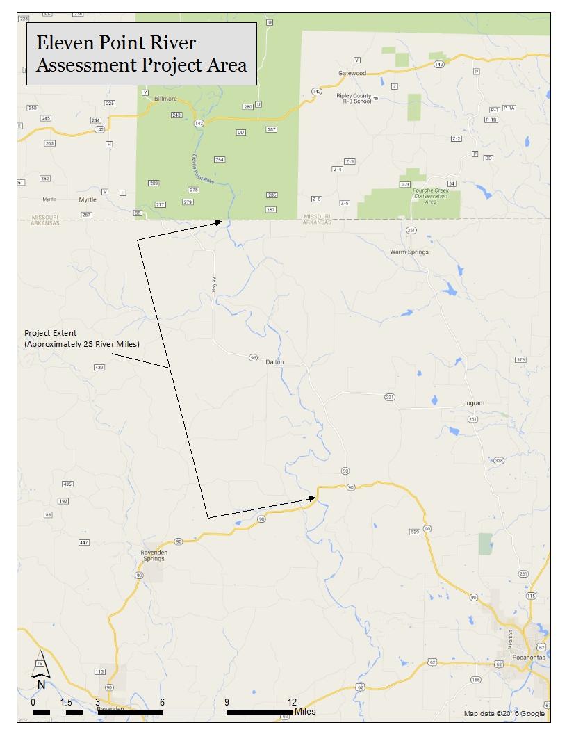
1 Project Title: Eleven Point River Streambank Erosion Assessment Project Summary: The project seeks to formally assess streambank erosion along the Eleven Point River in Arkansas, where sedimentation from streambank erosion is threatening extirpation of the endangered Ozark Hellbender. The assessment would include an investigation into historical land uses, a Bank Erosion Hazard Index survey and Near Bank Shear Stress survey to assess bank conditions and predict erosion rates. These actions would identify areas of greatest concern impacting a Species of Greatest Conservation Need within a priority watershed. The resulting data and information will be crucial to implementing conservation activities necessary to ensure long-term survival of the Ozark Hellbender. Project Leader: John Chapman, Watershed Conservation Program Director The Nature Conservancy 38 W. Trenton Blvd., Ste. 201 Fayetteville, AR john.chapman@tnc.org Project Partners: Melissa Lombardi, Biologist US Fish and Wildlife Service, Ecological Services Arkansas Field Office Melissa_lombardi@fws.gov Sean Saunders, Region 1 Stream Team Coordinator Arkansas Game and Fish Commission Sean.saunders@agfc.ar.gov Kelly Irwin, Herpetologist Arkansas Game and Fish Commission Kelly.Irwin@agfc.ar.gov Project Budget: SWG amount request: $21,660 Match provided: $11,727 Total project costs: $33,386
2 FY 2017 State Wildlife Grant Project Proposal Need: The endangered Ozark Hellbender is a large, strictly aquatic salamander endemic to streams of the Ozark Plateau in southern Missouri and northern Arkansas. Due to the species specialized habitat and diet requirements, changes to the aquatic environment have led to a significant reduction in hellbender populations. The Eleven Point River is a priority watershed in the Arkansas Wildlife Action Plan (AWAP) and is considered to be the last viable population of Ozark Hellbenders in the state. As noted in the AWAP, land use within the Eleven Point River watershed is rapidly changing and actions to survey physical habitat conditions within the watershed are needed to identify major threats and support conservation actions. Sediment inputs from land use activities significantly contribute to habitat degradation for a number of Species of Greatest Conservation Need in the Eleven Point River. Degraded riparian conditions and unpaved roads are presumably the two largest sources of sediment loading in the Eleven Point River. Since 2005, USFWS and Arkansas Game and Fish Commission have documented changes to habitat quantity and quality in the Eleven Point River due to sedimentation. Cover rocks necessary for Ozark Hellbenders have been embedded or completely buried at numerous sites. During monitoring efforts, artificial nest boxes have been documented to fill with fine sediment in less than three months, thereby hindering recovery efforts. This rapid siltation potentially provides insight into recruitment failure if similar siltation occurs under native cover rocks when egg clutches and larvae are present. While empirical data to document loss of cover rocks due to sedimentation are lacking, biologists with both agencies have visually observed increased fine sediments filling interstitial spaces and embedding (with fines and gravel) cover rocks at numerous sites occupied by Ozark Hellbender between the Missouri/Arkansas state line and Arkansas Highway 90. The effects of sedimentation become increasingly prominent as the Eleven Point extends downstream. An initial desktop review of historical and current aerial photography confirms channel widening due to stream bank erosion at over thirty sites between the state line and Arkansas Hwy 90. As the river channel widens and shallows, water velocity slows, leading to greater sedimentation and the shallow, slow moving water then warms. Biologists also have observed increases in aquatic macrophytes and large deposits of gravel near the confluence of tributaries following storm events, both indicators of bank erosion and resulting sedimentation throughout the reach. Purpose and Objectives: Identify and prioritize impaired reaches for potential streambank restoration in the Arkansas portion of the Eleven Point River with suitable habitat for Ozark Hellbender. This will be accomplished by completing a reconnaissance level survey of stream bank conditions, accompanied by validation of predicted erosion rates/sediment loads. A Bank Erosion Hazard Index (BEHI) survey will be conducted, which involves collecting streambank characteristics and conditions which affect bank erosivity. Near Bank Shear Stress (NBSS) will be estimated for each bank and, in conjunction with BEHI data, used to predict annual erosion rates for each impaired reach. Lateral erosion rates will be measured over a one-year period at the highest ranking reaches to validate the predicted values.
3 Geographic location: The Eleven Point River starting at the Arkansas/Missouri line and extending down river approximately 23 river miles to Arkansas Highway 90 (suitable habitat reach). See attached map. Approach: Record BEHI and NBSS data using a mapping grade GPS. This involves recording measurements of bank heights, angles, materials, presence of soil layers, rooting depth, rooting density, and percent of bank protection. These variables will be used to develop a streambank erodibility index and create a map using ESRI s ArcGIS. On this map, the attribute values of each section of stream are assigned an output risk rating from 1 to 10 indicating corresponding adjective values of risk as very low, low, moderate, high, very high, and extreme potential erodibility. A NBSS estimation will also be completed to predict total bank erosion, based on stream bank erodibility curves. The project would be expected to start in October 2017 with a reconnaissance level assessment, followed by BEHI and NBSS surveys in winter 2017/2018. Lateral erosion at high-risk reaches will be measured over the following year. All objectives should be accomplished within 2 years of start date, depending on flow characteristics. Results or benefits expected: The data produced from this study will identify the most critical reaches contributing sediment to the Arkansas portion of the Eleven Point River containing populations of the Ozark Hellbender. This data will help guide future streambank restoration priorities for improving riparian and instream conditions. Budget narrative: The total requested amount for this project is $21,660. TNC will provide match through supplies. Additional match will be provided by AGFC through staff time and travel to assist with the project. The combined match sources will provide $11,727, for a total project cost of $33,836. See Table 1 for estimated budget. Category Table 1: ESTIMATED BUDGET Salaries and Benefits $13,250 Travel $4,328 Supplies Other $0 Subtotal $ 17,578 Indirect Cost * $4,082 TOTAL $21,660 * TNC's indirect cost rate in its FY 18 NICRA is 23.22%. TNC's indirect rate is negotiated annually, and TNC will charge indirect at the federally approved rate each year.
4 Staff Qualifications: John Chapman, TNC - Watershed Restoration Program Director Responsible for overseeing the project. He is a graduate of the University of Arkansas at Monticello with a B.S. in Spatial Information Systems. He specializes in watershed and geomorphic assessments and design and implementation of stream restoration projects using natural channel design techniques. He has completed four intensive courses in Applied Fluvial Geomorphology and Natural Channel Design led by instructor Dave Rosgen, Ph.D., conducted numerous geomorphic surveys, and worked to implement stream restoration projects on the West Fork of the White River, Kings River, and Little Osage Creek. He also has 15 years of experience in the Geographic Information Systems (GIS) field. Chas McCoy, TNC Stream Restoration Technician Chas will provide support for various aspects of the project. He has a B.S. in Environmental Science from the University of Portland, Oregon and 8 years of experience in watershed management and stream restoration. He has completed Introduction to Applied Fluvial Geomorpholgy (Rosgen 1) by Dave Rosgen, Ph.D., and coursework in river restoration processes and design from Portland State University to receive a River Restoration Certificate. Chas has conducted BEHI and NBSS assessments in the Kings River watershed and is knowledgeable about stream processes. Dr. Melissa Lombardi, USFWS Endangered Species Biologist Dr. Lombardi is a veterinarian with the U.S. Fish and Wildlife Service. Her education includes: M.Sc. Fisheries and Wildlife Science, Arkansas Tech University (2014); DVM, Louisiana State University School of Veterinary Medicine (2000); B.A., Hendrix College (1995). Dr. Lombardi has worked with the Ozark hellbender at the St. Louis Zoo Ron Goellner Center for Hellbender Conservation and in interagency surveys and habitat enhancement projects on the Eleven Point River in Arkansas. Sean Saunders Sean Saunders graduated from the University of Arkansas at Little Rock in 2008 with a B.S. in Wildlife Management with an Emphasis on Fisheries. Upon graduation he worked as an intern for the AGFC under Stream Team Coordinator Stephen O Neal where he began his training in stream restoration. When the internship ended Sean took a position with the AGFC at the Jim Hinkle Spring River Hatchery and volunteered his free time to work with now retired Stream Team Coordinator Dave Evans and the Trout Habitat Manager Tim Burnley to increase his knowledge in stream restoration. In 2012 he took a position with the Arkansas Department of Environmental Quality (ADEQ) as a Water Inspector. This position allowed him to receive vast training and knowledge in water regulations and erosion. In 2015 Sean left ADEQ and took a Stream Team Coordinator position with the AGFC. Since returning to the AGFC as the Stream Team coordinator Sean has gone through Dr. Newbury s riffle training and Dr. Dave Rosgen s Level 1-3 training with plans to attend level 4 in September 2017.
5 Kelly Irwin, AGFC - Herpetologist Kelly Irwin began work as the first herpetologist for the Arkansas Game & Fish Commission in He is responsible for the conservation and management of the ~130 species of native amphibians and reptiles of Arkansas. In 2005, he initiated a long-term monitoring program on the Ozark Hellbender population in the Eleven Point River. Since 2012, he has been involved in the construction and maintenance of artificial shelters/ nest boxes in the river as a means to augment habitat and provide a possible source of egg clutches for captive propagation efforts at the St Louis Zoo Hellbender Conservation Center.
6
Birch Creek Geomorphic Assessment and Action Plan
 Birch Creek Geomorphic Assessment and Action Plan Jim Webster Tim Hanrahan, PhD, CFM Jesse Schwartz, PhD Zach Hill January 22, 2015 White Eagle Grange This Project is a First Step in Strategy Planning
Project Leader: Project Partners:
 UTILIZING LIDAR TO MAP HIGH PRIORITY WOODLAND HABITAT IN ARKANSAS DEVELOPING METHODOLOGY AND CONDUCTING A PILOT PROJECT IN THE OZARK HIGHLANDS TO MAP CURRENT EXTENT, SIZE AND CONDITION Project Summary
Project Budget: State Wildlife Grant Requested: $16,412 Project Match (UARK in kind services): $5,744 Total Project Cost: $22,156
: $5,744 Total Project Cost: $22,156") Project Title: Genetic examination of the Ringed Crayfish species group, with special emphasis on the endemic Gapped Ringed Crayfish (Orconectes neglectus chaenodactylus) Project Summary: Morphological
Project Title: Genetic examination of the Ringed Crayfish species group, with special emphasis on the endemic Gapped Ringed Crayfish (Orconectes neglectus chaenodactylus) Project Summary: Morphological
Lower South Fork McKenzie River Floodplain Enhancement Project
 Lower South Fork McKenzie River Floodplain Enhancement Project McKenzie River Ranger District Willamette National Forest Project Location The project is located in the South Fork McKenzie River Watershed,
Assessment. Assessment
 2001 SPRINGBROOK CREEK RESTORATION - THREE YEAR POST-CONSTRUCTION REVIEW - Presented by Bruce Henderson and Andy Harris 2005 River Restoration Northwest Symposium Skamania Lodge, Washington www.hendersonlandservices.com
Columbia Estuary Province
 Rolling Provincial Review: Implementation 2001-2004 Province 73 Columbia Basin Fish & Wildlife Authority Province FY 2001-2004 Spending Summaries NPCC Recommendations and BPA Spending by Project Category,
Watershed Assessment of River Stability and Sediment Supply: Advancing the Science of Watershed Analysis
 Watershed Assessment of River Stability and Sediment Supply: Advancing the Science of Watershed Analysis 2009 MWEA Annual Conference Rob Myllyoja, CET rmyllyoja@hrc-engr.com Watershed Assessment of River
PROJECT PARTNER: PROJECT PARTNER:
 PROJECT TITLE: Development of a Statewide Freshwater Mussel Monitoring Program in Arkansas PROJECT SUMMARY: A large data set exists for Arkansas' large river mussel fauna that is maintained in the Arkansas
Subcommittee on Sedimentation Draft Sediment Analysis Guidelines for Dam Removal
 Subcommittee on Sedimentation Draft Sediment Analysis Guidelines for Dam Removal August 4, 2011 Jennifer Bountry, M.S., P.E. Tim Randle, M.S., P.E., D.WRE. Blair Greimann, Ph.D., P.E. Sedimentation and
GENERAL SUMMARY BIG WOOD RIVER GEOMORPHIC ASSESSMENT BLAINE COUNTY, IDAHO
 GENERAL SUMMARY BIG WOOD RIVER GEOMORPHIC ASSESSMENT BLAINE COUNTY, IDAHO Prepared For Trout Unlimited 300 North Main Street, Hailey, Idaho, 83333 Prepared By P. O. Box 8578, 140 E. Broadway, Suite 23,
NATURE OF RIVERS B-1. Channel Function... ALLUVIAL FEATURES. ... to successfully carry sediment and water from the watershed. ...dissipate energy.
 1 2 Function... Sevier River... to successfully carry sediment and water from the watershed....dissipate energy. 3 ALLUVIAL FEATURES 4 CHANNEL DIMENSION The purpose of a stream is to carry water and sediment
Mobrand to Jones and Stokes. Sustainable Fisheries Management Use of EDT
 Sustainable Fisheries Management Use of EDT Ecosystem Diagnosis and Treatment EDT EDT designed to provide a practical, science-based approach for developing and implementing watershed plans. Provides decision
Geomorphology Studies
 Geomorphology Studies Technical Workgroup Meeting February 14, 2012 Prepared by: Tetra Tech Prepared for: Alaska Energy Authority Overall Goal Geomorphology Studies Two studies Geomorphology Study (RSP
Best Management Practices for Coldwater Fisheries Enhancement and Restoration
 Best Management Practices for Coldwater Fisheries Enhancement and Restoration MACC Annual Environmental Conference 2017 March 3, 2017 Tim Dexter, MassDOT Highway Division 1 Leading the Nation in Transportation
San Joaquin River Tributary Sediment Transport and Geomorphology Study
 Study 22 San Joaquin River Tributary Sediment Transport and Geomorphology Study Public Draft 2013 Monitoring and Analysis Plan September 2012 22.0 San Joaquin River Tributary Sediment Transport and Geomorphology
The Effects of Geomorphology and Watershed Land Use on Spawning Habitat
 The Effects of Geomorphology and Watershed Land Use on Spawning Habitat By Evan Buckland INTRODUCTION The distribution and frequency of large geomorphic features in a watershed govern where suitable spawning
United States Department of the Interior NATIONAL PARK SERVICE Northeast Region
 United States Department of the Interior NATIONAL PARK SERVICE Northeast Region June 17, 2017 REQUEST FOR STATEMENTS OF INTEREST and QUALIFICATIONS Project Title: ASSESSMENT OF NATURAL RESOURCE CONDITION
Wetland & Floodplain Functional Assessments and Mapping To Protect and Restore Riverine Systems in Vermont. Mike Kline and Laura Lapierre Vermont DEC
 Wetland & Floodplain Functional Assessments and Mapping To Protect and Restore Riverine Systems in Vermont Mike Kline and Laura Lapierre Vermont DEC NWI+ Hydro-Geomorphic Characterization of Wetlands and
NORTHUMBERLAND COUNTY, PA
 QUAKER RUN Stream and Wetland Restoration As-Built Completion Report and First Year Monitoring Data Coal Township NORTHUMBERLAND COUNTY, PA Upstream Before Upstream After Prepared for: COAL TOWNSHIP 805
Natural Shoreline Landscapes on Michigan Inland Lakes
 Natural Shoreline Landscapes on Michigan Inland Lakes Excerpts from Chapters 2 and 3 Photo Photo by Jane by Jane Herbert Herbert Did you know? Twenty-four species of amphibians, 25 species of reptiles,
Griswold Creek August 22, 2013
 Creek August 22, 2013 1 Lake Erie Protection Fund Creek Study ver Evaluate the overall condition of Creek Determine stable channel dimensions & appropriate restoration techniques Starting Stat gpoint for
Use of benthic invertebrate biological indicators in evaluating sediment deposition impairment on the Middle Truckee River, California
 Use of benthic invertebrate biological indicators in evaluating sediment deposition impairment on the Middle Truckee River, California David B. Herbst Sierra Nevada Aquatic Research Laboratory University
EAGLES NEST AND PIASA ISLANDS
 EAGLES NEST AND PIASA ISLANDS HABITAT REHABILITATION AND ENHANCEMENT PROJECT MADISON AND JERSEY COUNTIES, ILLINOIS ENVIRONMENTAL MANAGEMENT PROGRAM ST. LOUIS DISTRICT FACT SHEET I. LOCATION The proposed
Spring Run Spawning Habitat Assessment Sediment Mobility
 Study 47 Spring Run Spawning Habitat Assessment Sediment Mobility Final 2015 Monitoring and Analysis Plan January 2015 1.0 Spring Run Spawning Habitat Assessment Sediment Mobility Theme(s): Flow management
Coarse Sediment Augmentation on Regulated Rivers. Scott McBain McBain & Trush, Inc.
 Coarse Sediment Augmentation on Regulated Rivers Scott McBain McBain & Trush, Inc. scott@mcbaintrush.com Components Some geomorphic and ecological considerations Conceptual approach at understanding augmentation
Black Gore Creek 2013 Sediment Source Monitoring and TMDL Sediment Budget
 Black Gore Creek 2013 Sediment Source Monitoring and TMDL Sediment Budget Prepared for: Prepared By: - I. Introduction The Black Gore Creek Total Maximum Daily Load (TMDL) was developed in collaboration
Dam Removal Analysis Guidelines for Sediment
 A review of: Dam Removal Analysis Guidelines for Sediment Joe Rathbun (Retired) rathbunj@sbcglobal.net Some Potential Sediment Issues Reservoir restoration Downstream water quality Downstream deposition
Stream Geomorphology. Leslie A. Morrissey UVM July 25, 2012
 Stream Geomorphology Leslie A. Morrissey UVM July 25, 2012 What Functions do Healthy Streams Provide? Flood mitigation Water supply Water quality Sediment storage and transport Habitat Recreation Transportation
Fluvial Geomorphic Guidelines
 Fluvial Geomorphic Guidelines FACT SHEET I: GEOMORPHOLOGICAL HAZARDS CONFINED AND UNCONFINED WATERCOURSES Channel migration and erosion can create substantial risk to inappropriately located infrastructure
Why Geomorphology for Fish Passage
 Channel Morphology - Stream Crossing Interactions An Overview Michael Love Michael Love & Associates mlove@h2odesigns.com (707) 476-8938 Why Geomorphology for Fish Passage 1. Understand the Scale of the
SEARCHING FOR SEDIMENT SOURCES IN SPRING CREEK
 SEARCHING FOR SEDIMENT SOURCES IN SPRING CREEK Christopher Frederick, Department of Earth Sciences, University of South Alabama, Mobile, AL 36688. E-mail: cjf702@jaguar1.usouthal.edu. Sediment deposition
ADDRESSING GEOMORPHIC AND HYDRAULIC CONTROLS IN OFF-CHANNEL HABITAT DESIGN
 ADDRESSING GEOMORPHIC AND HYDRAULIC CONTROLS IN OFF-CHANNEL HABITAT DESIGN Conor Shea - Hydrologist U.S. Fish and Wildlife Service Conservation Partnerships Program Arcata, CA Learning Objectives Examine
Bank Erosion and Morphology of the Kaskaskia River
 Bank Erosion and Morphology of the Kaskaskia River US Army Corps Of Engineers St. Louis District Fayette County Soil and Water Conservation District Team Partners : Carlyle Lake Ecosystem Partnership Vicinity
Ecological Land Cover Classification For a Natural Resources Inventory in the Kansas City Region, USA
 Ecological Land Cover Classification For a Natural Resources Inventory in the Kansas City Region, USA by Applied Ecological Services, Inc. In cooperation with the Mid-America Regional Council 600 Broadway,
RAILWAYS AND FISH: HOW TO PROTECT AND ENHANCE FISH HABITAT VALUES AT STREAM CROSSINGS THROUGH PROJECT DESIGN AND CONSTRUCTION
 RAILWAYS AND FISH: HOW TO PROTECT AND ENHANCE FISH HABITAT VALUES AT STREAM CROSSINGS THROUGH PROJECT DESIGN AND CONSTRUCTION Rail Environment Conference November 2016 AGENDA Objective Background Benefits
Swift Creek Sediment Management Action Plan (SCSMAP)
") Swift Creek Sediment Management Action Plan (SCSMAP) PHASE 2 PROJECT PLAN PROPOSAL Whatcom County Public Works Department 322 N. Commercial Street, Suite 210 Bellingham, WA 98225 (360) 676-6692 June 2013
Swift Creek Sediment Management Action Plan (SCSMAP) PHASE 2 PROJECT PLAN PROPOSAL Whatcom County Public Works Department 322 N. Commercial Street, Suite 210 Bellingham, WA 98225 (360) 676-6692 June 2013
Step 5: Channel Bed and Planform Changes
 Step 5: Channel Bed and Planform Changes When disturbed, streams go through a series of adjustments to regain equilibrium with the flow and sediment supply of their watersheds. These adjustments often
When Creek Meets Valley Wall: Prioritizing Erosion Mitigation alongside the Oshawa Landfill
 1 When Creek Meets Valley Wall: Prioritizing Erosion Mitigation alongside the Oshawa Landfill Robin McKillop 1, Dan McParland 1 & Cassie Scobie 2 TRIECA conference March 22-23, 2017 1 Palmer Environmental
Limitation to qualitative stability indicators. the real world is a continuum, not a dichotomy ~ 100 % 30 % ~ 100 % ~ 40 %
 Stream Stability Assessment & BEHI Surveys Joe Rathbun MDEQ Water Resources Division rathbunj@michigan.gov 517--373 517 373--8868 Stability Stream can transport its water and sediment inputs without changing
Solutions to Flooding on Pescadero Creek Road
 Hydrology Hydraulics Geomorphology Design Field Services Photo courtesy Half Moon Bay Review Solutions to Flooding on Pescadero Creek Road Prepared for: San Mateo County Resource Conservation District
Session C1 - Applying the Stream Functions Pyramid to Geomorphic Assessments and Restoration Design
 University of Massachusetts - Amherst ScholarWorks@UMass Amherst International Conference on Engineering and Ecohydrology for Fish Passage International Conference on Engineering and Ecohydrology for Fish
APPENDIX E. GEOMORPHOLOGICAL MONTORING REPORT Prepared by Steve Vrooman, Keystone Restoration Ecology September 2013
 APPENDIX E GEOMORPHOLOGICAL MONTORING REPORT Prepared by Steve Vrooman, Keystone Restoration Ecology September 2 Introduction Keystone Restoration Ecology (KRE) conducted geomorphological monitoring in
Design of Levee Breaches in Sheltered Water for Flood Risk Reduction & Marsh Restoration ASFMP; June 5, 2014 Presented By:
 Design of Levee Breaches in Sheltered Water for Flood Risk Reduction & Marsh Restoration ASFMP; June 5, 2014 Presented By: Rohin Saleh Alameda County Flood Control District Matt Powers, P.E. GEI Consultants
Geomorphology Of The Chilliwack River Watershed Landform Mapping At North Cascades National Park Service Complex, Washington By National Park Service
 Geomorphology Of The Chilliwack River Watershed Landform Mapping At North Cascades National Park Service Complex, Washington By National Park Service READ ONLINE Snowshed contributions to the Nooksack
Avoiding Geohazards in the Mid-Atlantic Highlands by Using Natural Stream Principles
 Avoiding Geohazards in the Mid-Atlantic Highlands by Using Natural Stream Principles J. Steven Kite, WVU Neal Carte, WVDOT Will Harman, Michael Baker Corp. Donald D. Gray, WVU Photo: W. Gillespie North
Mapping Watershed-scale Streambank Erosion Using EPA- BANCS for Determining TMDLs
 Mapping Watershed-scale Streambank Erosion Using EPA- BANCS for Determining TMDLs Paul Ayers, K. Hensley, D. Wade Biosystems Engineering & Soil Science University of Tennessee K. Swinson (Geosyntec), B.
EXECUTIVE SUMMARY (Continued)
") EXECUTIVE SUMMARY In 1980, Congress passed the Pacific Northwest Electric Power Planning and Conservation Act which authorized creation of the Northwest Power and Conservation Council by the states of
EXECUTIVE SUMMARY In 1980, Congress passed the Pacific Northwest Electric Power Planning and Conservation Act which authorized creation of the Northwest Power and Conservation Council by the states of
Title of the Project: Distribution and population status of Arkansas bumble bees
 Title of the Project: Distribution and population status of Arkansas bumble bees Project Summary: The goal of this project is to determine the distribution and population status of bumble bees in Arkansas.
Fish Passage and Abundance around Grade Control Structures on Incised Streams in Western Iowa
 Fish Passage and Abundance around Grade Control Structures on Incised Streams in Western Iowa John Thomas Hungry Canyons Alliance Mary Culler Iowa State University / Missouri DNR Dimitri Dermisis IIHR
APPENDIX A REACH DECRIPTIONS. Quantico Creek Watershed Assessment April 2011
 APPENDIX A REACH DECRIPTIONS Basin 615, South Fork of Quantico Creek - Project Reach Descriptions Reach Name: 615-A Coordinates (NAD 83, Virginia State Plane North): 11796510.57, 6893938.95 to 11801555.79,
Carmel River Bank Stabilization at Rancho San Carlos Road Project Description and Work Plan March 2018
 Carmel River Bank Stabilization at Rancho San Carlos Road Project Description and Work Plan March 2018 EXISTING CONDITION The proposed Carmel River Bank Stabilization at Rancho San Carlos Road Project
Sediment Deposition LET THE RIVER RUN T E A C H E R. Activity Overview. Activity at a Glance. Time Required. Level of Complexity.
 Activity at a Glance Grade: 6 9 Subject: Science Category: Physical Science, Earth Science Topic: Deposition, River Systems Time Required Two 45-minute periods Level of Complexity Medium Materials* TI-73
Roger Andy Gaines, Research Civil Engineer, PhD, P.E.
 Roger Andy Gaines, Research Civil Engineer, PhD, P.E. Research Civil Engineer/Regional Technical Specialist Memphis District August 24, 2010 Objectives Where we have been (recap of situation and what s
MEANDER MIGRATION MODEL ASSESSMENT FOR THE JANUARY 2005 STORM, WHITMAN PROPERTY, SAN ANTONIO CREEK, VENTURA COUNTY, CALIFORNIA
 MEANDER MIGRATION MODEL ASSESSMENT FOR THE JANUARY 2005 STORM, WHITMAN PROPERTY, SAN ANTONIO CREEK, VENTURA COUNTY, CALIFORNIA Prepared by Eric Larsen, Ph.D. Mark Rains, Ph.D. October 2006 INTRODUCTION
Summary Description Municipality of Anchorage. Anchorage Coastal Resource Atlas Project
 Summary Description Municipality of Anchorage Anchorage Coastal Resource Atlas Project By: Thede Tobish, MOA Planner; and Charlie Barnwell, MOA GIS Manager Introduction Local governments often struggle
Rapid Geomorphic Assessments: RGA s
 Establishing Current Reference Conditions Rates and concentrations of suspended-sediment transport vary over time and space due to factors such as precipitation characteristics and discharge, geology,
Massachusetts Rivers & Roads Training
 Massachusetts Rivers & Roads Training Using Fluvial Geomorphology (FGM) to Reduce Conflicts Between Transportation Assets and Rivers Roy Schiff, Jessica Louisos, and Jim MacBroom, Milone & MacBroom Tim
Background. North Cascades Ecosystem Grizzly Bear Restoration Plan/ Environmental Impact Statement. Steve Rochetta
 Grizzly Bear Restoration Plan/ Environmental Impact Statement Steve Rochetta Background Situated in the core of the North Cascades ecosystem (NCE), the North Cascades National Park Complex is surrounded
Appendix I: The Summit-at-Snoqualmie Master Development Plan Proposal FEIS Physical and Biological Resource Data Tables
 Appendix I: The Summit-at-Snoqualmie Master Development Plan Proposal FEIS Physical and Biological Resource Data Tables DPC Tables Rationale for DPC Analysis Parameters for 7 th Field Watersheds for The
In-channel coarse sediment trap Best Management Practice
 In-channel coarse sediment trap Best Management Practice By Henry R. Hudson July 2002 Environmental Management Associates Ltd., Christchurch Complexity Environmental Value Cost Low Moderate High Low Moderate
low turbidity high turbidity
 What is Turbidity? Turbidity refers to how clear the water is. The greater the amount of total suspended solids (TSS) in the water, the murkier it appears and the higher the measured turbidity. Excessive
Overview of fluvial and geotechnical processes for TMDL assessment
 Overview of fluvial and geotechnical processes for TMDL assessment Christian F Lenhart, Assistant Prof, MSU Research Assoc., U of M Biosystems Engineering Fluvial processes in a glaciated landscape Martin
Validation of BEHI Model through Field Generated Data for Assessing Bank Erosion along the River Haora, West Tripura, India
 Open access e-journal Earth Science India, eissn: 0974 8350 Vol. 6 (III), July, 2013, pp. 126-135 http://www.earthscienceindia.info/ Validation of BEHI Model through Field Generated Data for Assessing
Learning Objectives: I can identify and interpret river flows and directions.
 Learning Objectives: I can identify and interpret river flows and directions. Bellringer Review: Check for Understanding Questions: 1 2 What Are The Key Parts Of A River s Anatomy? In your data notebooks
The Refugia Concept: Using Watershed Analysis to Prioritize Salmonid Habitat for Conservation and Restoration
 The Refugia Concept: Using Watershed Analysis to Prioritize Salmonid Habitat for Conservation and Restoration Christopher May Battelle & UW Cumulative Impacts of Urbanization Landscape Alterations Loss
Dolores River Watershed Study
 CHAPTER 4: RIVER AND FLOODPLAIN ISSUES The Dolores River falls into a category of streams in Colorado that share some unique characteristics. Like some other mountain streams in the state, it has a steep
How Do Human Impacts and Geomorphological Responses Vary with Spatial Scale in the Streams and Rivers of the Illinois Basin?
 How Do Human Impacts and Geomorphological Responses Vary with Spatial Scale in the Streams and Rivers of the Illinois Basin? Bruce Rhoads Department of Geography University of Illinois at Urbana-Champaign
Woodstock, Route 26 Stream Relocation Project
 MAINE DEPARTMENT OF TRANSPORTATION 2006 POST - CONSTRUCTION MONITORING REPORT: Woodstock, Route 26 Stream Relocation Project Year 1 of 5 Compensation for the Woodstock, Route 26 Highway Reconstruction
FOREST RESEARCH INSTITUTE, DEHRADUN
 PROJECT REPORT DRAINAGE AND REPLENISHMENT STUDY OF MINED AREA OF GANGA SHYAMPUR RIVER HARIDWAR Submitted to UTTARAKHAND FOREST DEVELOPMENT CORPORATION (UFDC) 73, Nehru Road, Deharadun Prepared&Submitted
Ways To Identify Background Verses Accelerated Erosion
 Ways To Identify Background Verses Accelerated Erosion Establish Background Condition From Old Ground Photos, Aerial Photos, and Maps Compare Rate Over Time At the Same Location, or for Reaches Channel
Savannah District s Revised SOP: Moving Towards A Functional Approach. US Army Corps of Engineers BUILDING STRONG
 Savannah District s Revised SOP: Moving Towards A Functional Approach US Army Corps of Engineers Agenda SOP Revision Concept New Aquatic Resource Credit Types New Urban Mitigation Service Area Filter Background
Working with Natural Stream Systems
 Working with Natural Stream Systems Graydon Dutcher Delaware County Soil & Water Conservation District Stream Corridor Management Program Tropical Storm Sandy October 29,2012 What is a Watershed?
Hannah Moore CEE Juvenile Bull Trout Distribution in the South Fork Walla Walla River, Oregon
 Hannah Moore CEE 6440 Juvenile Bull Trout Distribution in the South Fork Walla Walla River, Oregon Introduction Bull trout (Salvelinus confluentus) are an endangered species historically found throughout
Case Study 2: Twenty-mile Creek Rock Fords
 Case Study : Twenty-mile Creek Rock Fords Location Crossing Description Washington. Okanagan National Forest. Methow Valley Ranger District. Chewuch river basin, East Chewuch Road. The Twenty-mile Creek
APPLIED FLUVIAL GEOMORPHOLOGY
 APPLIED FLUVIAL GEOMORPHOLOGY Where have we come from, where do we go? Roger TJ Phillips Mariëtte Pushkar and Peter Ashmore Value of Geomorphologists in River Management Start with Historical Geology and
PolyMet NorthMet Project
 RS 26 Draft-01 December 8, 2005 RS26 Partridge River Level 1 Rosgen Geomorphic Survey Rosgen Classification Partridge River from Headwaters to Colby Lake Prepared for PolyMet NorthMet Project December
Upper Manistee River Instream Fish Habitat Assessment
 1 Upper Manistee River Instream Fish Habitat Assessment Michigan Trout Unlimited January 216 Kristin Thomas Dr. Bryan Burroughs 2 Table of Contents INTRODUCTION... 4 Table 1. Michigan stream and river
Opportunities to Improve Ecological Functions of Floodplains and Reduce Flood Risk along Major Rivers in the Puget Sound Basin
 Opportunities to Improve Ecological Functions of Floodplains and Reduce Flood Risk along Major Rivers in the Puget Sound Basin Christopher Konrad, US Geological Survey Tim Beechie, NOAA Fisheries Managing
Measuring Streambank Erosion Bank Profiles to more Robustly Estimate Recession Rates and Calibration of the AnnAGNPS-CEAP Model
 Measuring Streambank Erosion Bank Profiles to more Robustly Estimate Recession Rates and Calibration of the AnnAGNPS-CEAP Model Clare Prestwich, P.E. 1 & W. Barry Southerland, Ph.D. 2 Water Quality and
A GEOMORPHOLOGICAL APPROACH TO RESTORATION OF INCISED RIVERS. David L. Rosgen 1
 Proceedings of the Conference on Management of Landscapes Disturbed by Channel Incision, 1997 S.S.Y. Wang, E.J. Langendoen and F.D. Shields, Jr. (eds.) ISBN 0-937099-05-8 A GEOMORPHOLOGICAL APPROACH TO
Restoring the Napa River:
 Restoring the Napa River: lessons learned from a long term private-public project Andy Collison Environmental Science Associates acollison@esassoc.com 1 Napa River Restoration Projects Rutherford Reach
Conceptual Model of Stream Flow Processes for the Russian River Watershed. Chris Farrar
 Conceptual Model of Stream Flow Processes for the Russian River Watershed Chris Farrar Several features of creeks affect the interactions between surface and groundwater. This conceptual model uses the
Why Stabilizing the Stream As-Is is Not Enough
 Why Stabilizing the Stream As-Is is Not Enough Several examples of alternatives to the County s design approach have been suggested. A common theme of these proposals is a less comprehensive effort focusing
Four Mile Run Levee Corridor Stream Restoration
 Four Mile Run Levee Corridor Stream Restoration 30% Design Summary U.S. Army Corps of Engineers, Baltimore District Presentation Outline Four Mile Run 1.) Historic Perspective 2.) Existing Conditions 3.)
YUBA COUNTY WATER AGENCY
 YUBA COUNTY WATER AGENCY Representative Site Selection Above Englebright Reservoir Stream Fish, Aquatic BMI, Aquatic Mollusks Yuba County Water Agency Yuba River Development Project FERC Project No. 2246
The last three sections of the main body of this report consist of:
 Threatened and Endangered Species Geological Hazards Floodplains Cultural Resources Hazardous Materials A Cost Analysis section that provides comparative conceptual-level costs follows the Environmental
Date of Report: EPA agreement number: Center Name and Institution of Ctr. Director: Identifier used by Center for Project: Title of Project:
 Date of Report: March 31, 2003 EPA agreement number: R829515C003 Center Name and Institution of Ctr. Director: Rocky Mountain Regional Hazardous Substance Research Center, Colorado State University, Fort
Kootenai River Habitat Restoration Program Update
 Kootenai River Habitat Restoration Program Update Kootenai Tribe of Idaho Kootenai Valley Resource Initiative November 19, 2012 Bonners Ferry, Idaho Changes to Kootenai Basin Beaver trapping Floodplain
SEDIMENT BENEFICIAL USE SUPPORT ASSESSMENT FOR OTTER CREEK
 SEDIMENT BENEFICIAL USE SUPPORT ASSESSMENT FOR OTTER CREEK Addresses Otter Creek Assessment Unit MT42C002_020 Prepared by: Kristy Fortman November 15, 2013 1 1.0 INTRODUCTION In the spring of 2013, the
Biological Response to the Gold King Mine Release in the Animas and San Juan Rivers
 Biological Response to the Gold King Mine Release in the and San Juan Rivers Lareina Guenzel 1, Richard Mitchell, PhD 1, Kate Sullivan, PhD 2, and Michael Cyterski, PhD 2 1 U.S. Environmental Protection
PHASE 1 STREAM GEOMORPHIC ASSESSMENT. Castleton River, Rutland County Vermont. Final Report
 PHASE 1 STREAM GEOMORPHIC ASSESSMENT Castleton River, Rutland County Vermont Final Report September 15, 2005 TABLE OF CONTENTS INTRODUCTION.. 3 STUDY AREA BACKGROUND... 5 METHODOLOGY 5 DATA INPUTS/STUDY
HAW CREEK, PIKE COUNTY, MISSOURI-TRIB TO SALT RIVER ERODING STREAM THREATHENING COUNTY ROAD #107, FOURTEEN FT TALL ERODING BANK WITHIN 4 FT OF THE
 HAW CREEK, PIKE COUNTY, MISSOURI-TRIB TO SALT RIVER ERODING STREAM THREATHENING COUNTY ROAD #107, FOURTEEN FT TALL ERODING BANK WITHIN 4 FT OF THE ROAD, PROJECT CONSTRUCTED IN 1 DAY, MARCH 10, 2009 BY
What is a watershed or landscape perspective?
 What is a watershed or landscape perspective? -remove sediment -add sediment -add wood, riparian manipulation -alter (engineer) channel/floodplain morphology -restore/abandon roads You are here What is
WATERSHED RESTORATION PLANNING AND PRIORITY SETTING. An Emphasis on Fish Habitat
 WATERSHED RESTORATION PLANNING AND PRIORITY SETTING An Emphasis on Fish Habitat March 2004 This document was modified from Planning and Priority Setting for the Next Five Years, Phase 3 Watershed-Level
Goundwater Seepage Mechanisms of Streambank Erosion and Failure
 Goundwater Seepage Mechanisms of Streambank Erosion and Failure Taber L. Midgley M.S. Student Garey A. Fox Associate Professor Abdulsahib Al-Madhhachi Ph.D. Student Rachel Carson M.S. Student Biosystems
Little Blackfoot TPA 2009 Sediment and Habitat Assessment QAQC Review March 9, 2010
 Little Blackfoot TPA 2009 Sediment and Habitat Assessment QAQC Review March 9, 2010 1.0 PROJECT OVERVIEW Sediment and habitat monitoring in the Little Blackfoot TPA was conducted in July of 2009 as outlined
Important Copyright Information
 Important Copyright Information The following content is provided for educational purposes by the workshop presenter. This content may or may not have been peer reviewed. Information, opinions and recommendations
Use of Bioengineering Techniques for Revegetation of Riparian Areas: Colomac Mine Remediation Project, NWT
 Use of Bioengineering Techniques for Revegetation of Riparian Areas: Colomac Mine Remediation Project, NWT McPherson, M. 1, Vanderspiegel, R. 2, Breadmore, R. 2, and Hewitt, M. 3 2012 RPIC Federal Contaminated
CASE STUDIES. Introduction
 Introduction The City of Winston-Salem faces the challenge of maintaining public infrastructure (e.g., water and sewer lines, storm drains, roads, culverts and bridges) while minimizing the potential impacts
Integrated methodology for assessing the effects of geomorphological river restoration on fish habitat and riparian vegetation
 Integrated methodology for assessing the effects of geomorphological river restoration on fish habitat and riparian vegetation Judit Maroto *a, Miguel Marchamalo a,b, Diego García de Jalón a, Marta González