PHOTO ESSAY: Geologic Journeys
|
|
|
- Laureen Norris
- 5 years ago
- Views:
Transcription


1 PHOTO ESSAY: Geologic Journeys Turnagain Arm Tidal Bore Earthcache 1


2 KAME & KETTLE EARTHCACHE Located at Little Campbell Lake on Kincaid Park s NE corner, the EarthCache requires a journey around the lake while measuring various details and searching for the lake s drainage point GC1WHTP THE NETHERLANDS AMSTERDAM, NETHERLANDS Explained The Netherlands ongoing efforts to keep the sea from inundating the country, including a real-time tide level exhibit 2


3 Explanatory Graphics from cache page Illustrate the processes described Visualize the landscape development Show the site across geologic time Visible at left are seashells located in the exposed eroding flank of a hillside adjacent to a sidewalk at San Pedro CA s Urban Unconformity EarthCache. The seashells are approximately 100,000 years old. The image above is a close up view of the area boxed in yellow at lower left center. 3


4 GC2E4YF - HOULLAY - HOHLFELS BERDORF, LUXEMBOURG Millstone Grit Quarry turned into performing arts amphitheater in Luxembourg s Little Switzerland region Pothole Dome EarthCache, CA - located within Yosemite Nat l Park, makes good use of diagrams to illustrate the geologic processes which have helped create the landscape to be examined by the visiting geocacher. The view of Tuolumne Meadow from the cache site is another stunning feature! 4


5 GC1TFZJ FLYSCH ST. JEAN DE LUZ, FRANCE Folded and tilted schist and clastic rocks Green Sand Beach, Olivine EarthCache, Big Island, Hawaii Dry Waterfall Keyhole Canyon EC Boulder, NV Lower Menomonee Falls, Lime Kiln EC, Menomonee, MI 5


6 Confluence of the Shenandoah and Potomac Rivers Geologic Map of the confluence of the Shenandoah & Potomac Rivers, at the River Runs Through It Earthcache, Harpers Ferry WV Thomas Jefferson called this the prettiest spot in America where two rivers cut through the ancient rock of the Allegheny Mountains. GC255T1 - BUSSANA VECCHIA BUSSANA, ITALY 9 th century town abandoned after 1887 earthquake 6


7 Top view of the Mississippi River from the EarthCache at Effigy Mounds Nat l Mon., Iowa Left Delicate Arch EarthCache, Arches National Park, Utah Below: Butler Wash Natural Bridge and Cliff Dwellings, SE Utah Right: Techatticup Natural Bridge Earthcache, south of Boulder, NV Below Right: Prickly Pear Cactus May bloom Moab, UT 7


8 5/28/2011 GC1CEEK - LA GOLA DELLA VIAMALA RONGELLEN, SWITZERLAND 300m deep river gorge used as trade route dating back to Roman times Details Cruziana EC page, Portugal Drawings illustrate what made tracks And how movement has been fossilized To explain what cachers will find onsite 8


9 Copper Ridge Dinosaur Tracks EarthCache near Moab, Utah. The cache listing provided better information on access, what to expect to see, how the tracks had been preserved, and what dinosaurs were involved than was available from the BLM s meager information on the web. A stunning site preserving an event out of time GC1ATH8 TALLGRASS PRAIRIE CUESTAS PAWHUSKA, OKLAHOMA Five stops along an 18-mile drive through the Tallgrass Prairie Preserve featured cliffs, drainages, rolling prairie, and bison 9


10 Oxbow Meander EarthCache, Yosemite NP Meander explained on cache page Oxbow Meander Detail Yosemite National Park, California Cologne EarthCache a historic site listing, educating the cacher about what makes up the stone structure of the Cathedral and where that stone originated Cathedral West Façade view GPS and the Towers Cologne EarthCache, Germany 10


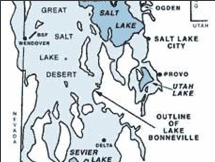


11 GC1HM11 ELGIN SANDSTONE: DEPOSITIONAL FEATURES, PAWHUSKA, OKLAHOMA 400m walk along a cuesta was a walk backwards in time with eight different depostitional/sedimentary features to identify Ancient Bonneville Lake EC. Utah Detail illustrating ancient lake levels Detail map of EarthCache Zone Cacher s photo Ancient Bonneville EC 11


12 Left: Butler Wash Overlook EarthCache, UT Center: EarthCache at Cape Hatteras, NC Right: One of Joshua Tree Nat l Pk s many earthcaches 12
4. The map below shows a meandering stream. Points A, B, C, and D represent locations along the stream bottom.
 1. Sediment is deposited as a river enters a lake because the A) velocity of the river decreases B) force of gravity decreases C) volume of water increases D) slope of the river increases 2. Which diagram
Changes to Land 5.7B. landforms: features on the surface of Earth such as mountains, hills, dunes, oceans and rivers
 All the landforms on Earth have changed over time and continue to change. Many of the changes were caused by wind, moving water, and moving ice. Mountains have grown and shrunk. Rivers have cut away land
Think about the landforms where you live. How do you think they have changed over time? How do you think they will change in the future?
 reflect All the landforms on Earth have changed over time and continue to change. Many of the changes were caused by wind, moving water, and moving ice. Mountains have grown and shrunk. Rivers have cut
BISTI / DE-NA-ZIN WILDERNESS
 BISTI / DE-NA-ZIN WILDERNESS Activities: Facilities: Season / Hours: Description: Hiking and photography. No electrical hookups, water, or restrooms are available. Open year-round. The Bisti/De-Na-Zin
Summer 2014 Reading the Geologic History of Doheny State Beach Rodger More LAYERS LET S TAKE A TOUR THE BLUFFS
 Summer 2014 Reading the Geologic History of Doheny State Beach Rodger More DSBIA Board Officer and Geologist (retired) LAYERS of sediment and rock are like a book. Formations make up chapters and individual
Module 10: Resources and Virginia Geology Topic 4 Content: Virginia Geology Notes
 Virginia is composed of a very diverse landscape that extends from the beaches and barrier islands all of the way to the highly elevated Appalachian Plateau. Geologists have discovered ancient shallow
State the principle of uniformitarianism. Explain how the law of superposition can be used to determine the relative age of rocks.
 Objectives State the principle of uniformitarianism. Explain how the law of superposition can be used to determine the relative age of rocks. Compare three types of unconformities. Apply the law of crosscutting
Earth History: Record in the Rocks
 Earth History: Record in the Rocks The geologic history of Earth can be read from rocks if you know what to look for. In this presentation, you will see examples of many types of clues, stored in rocks.
5. Compare the density of the oceanic crust to continental crust. 6. What kind of plate boundary is this? convergent
 The youngest rock is in the middle (at ridge) and it gets older on either side as you move away in a symmetrical pattern. 1. How does the age of the seafloor compare on either side of the ridge? A = youngest
TAKE HOME EXAM 8R - Geology
 Name Period Date TAKE HOME EXAM 8R - Geology PART 1 - Multiple Choice 1. A volcanic cone made up of alternating layers of lava and rock particles is a cone. a. cinder b. lava c. shield d. composite 2.
Bryce Canyon. Bryce Zion
 Bryce Canyon Located ~50 mi NE of Zion in southern Utah On Paunsaugunt Plateau: Wetter and Colder than Zion Bounded by Sevier Fault to west and Paunsaugunt Fault to east Rocks are ~100 Ma older than at
How does erosion happen?
 How does erosion happen? By National Geographic, adapted by Newsela staff on 10.03.17 Word Count 682 Level 830L These rock formations, in Bryce Canyon National Park, Utah, are called hoodoos. Although
test date Name date Review: Geologic Time & Geologic Procesess-: You will record 1-38 answers on the scan sheet! These are worth 1.
 Review: Geologic Time & Geologic Procesess-: You will record 1-38 answers on the scan sheet! These are worth 1.5 points each Use your EARTH HISTORY CHART Part I. Matching All of the statements match to
discussion of North America s physical features, including its landforms and bodies of
 Chapter 7 Natural Environments of North America Chapter 7 focuses on the natural environments of North America. The chapter opens with a discussion of North America s physical features, including its landforms
LANDFORM REGIONS IN CANADA. Classroom Notes and Descriptions
 LANDFORM REGIONS IN CANADA Classroom Notes and Descriptions Landform Regions in Canada There are eight distinct landforms in Canada: Western Cordillera Region Interior Plains Canadian Shield Hudson Bay
Landforms. Why does the land look like it does? 1. Controlled by water 2. Controlled by the rocks
 Landforms Why does the land look like it does? 1. Controlled by water 2. Controlled by the rocks Landforms Made by Running Water Stream erosion The evolution of a river system Entrenched meanders Fluvial
Basin & Range / Mojave Desert
 Basin & Range / Mojave Desert Basin & Range vs. Great Basin 1 2/20/2016 An overview of the last horst Basin and Range / Mojave Desert Summary: Granitic, volcanic, marine sedimentary, non marine sedimentary,
EROSION AND DEPOSITION
 CHAPTER 8 EROSION AND DEPOSITION SECTION 8 1 Changing Earth s Surface (pages 252-255) This section explains how sediment is carried away and deposited elsewhere to wear down and build up Earth s surface.
guided notes Work Day WPA Posters!
 Bellringer D4 Get out your guided notes, prepare for the quiz review! Rules: Each table needs at least one device connected to the Kahoot You can help your neighbor during the review Questions are fast;
Movement of the Earth s Crust: Formation of: Mountain s Plateau's and Dome s
 Movement of the Earth s Crust: Formation of: Mountain s Plateau's and Dome s References Information taken from several places including Prentice Hall Earth Science: @ http://www.eram.k12.ny.us/education/components/docmgr/default.php?sectiondetaili
3/28/08 EB14 Recommendations
 3/28/08 EB14 Recommendations Recommendations for Wayside Integration Strip Version 1 revise markers along the timeline so visitors don t try to establish a one-to-one correspondence with the real trail
The boulder was most likely moved to this location by A) glacial ice B) prevailing wind C) streamfiow D) volcanic action
 glacial ice B) prevailing wind C) streamfiow D) volcanic action") 1. Which rock material was most likely transported to its present location by a glacier? A) rounded sand grains found in a river delta B) rounded grains found in a sand dune C) residual soil found on a
1. Which rock material was most likely transported to its present location by a glacier? A) rounded sand grains found in a river delta B) rounded grains found in a sand dune C) residual soil found on a
Notes and Summary pages:
 Topographic Mapping 8.9C Interpret topographical maps and satellite views to identify land and erosional features and predict how these shapes may be reshaped by weathering ATL Skills: Communication taking
STAAR Science Tutorial 40 TEK 8.9C: Topographic Maps & Erosional Landforms
 Name: Teacher: Pd. Date: STAAR Science Tutorial 40 TEK 8.9C: Topographic Maps & Erosional Landforms TEK 8.9C: Interpret topographic maps and satellite views to identify land and erosional features and
Finding Fault Geologic History from a Road Cut
 Finding Fault Geologic History from a Road Cut Elisabeth M. Price, DD LaPointe, and Jonathan G. Price 4 July 2005 Introduction Earth science is an important science to present to students because it directly
depression above scarp scarp
 1 LAB 1: FIELD TRIP TO McKINLEYVILLE AND MOUTH OF THE MAD RIVER OBJECTIVES: a. to look at geomorphic and geologic evidence for large scale thrust-faulting of young sediments in the Humboldt Bay region
1. Base your answer to the following question on the map below, which shows the generalized bedrock of a part of western New York State.
 1. Base your answer to the following question on the map below, which shows the generalized bedrock of a part of western New York State. 3. The table below describes the deposits that an observer saw while
Writing Earth s History
 Earths History Writing Earth s History How is Earths History like writing in your Journal? Everyday, something happens and, with a pen, it is written down in the pages of your journal. As you continue,
Science EOG Review: Landforms
 Mathematician Science EOG Review: Landforms Vocabulary Definition Term canyon deep, large, V- shaped valley formed by a river over millions of years of erosion; sometimes called gorges (example: Linville
Figure 1 The map shows the top view of a meandering stream as it enters a lake. At which points along the stream are erosion and deposition dominant?
 1. In which type of climate does chemical weathering usually occur most rapidly? 1. hot and dry 3. cold and dry 2. hot and wet 4. cold and wet 2. Figure 1 The map shows the top view of a meandering stream
Geotechnical Aspects of the Ohio River Bridges Project
 Geotechnical Aspects of the Ohio River Bridges Project Mark A. Litkenhus, PE Sr. Geotechnical Engineer Stephen H. Bickel, PE Sr. Geotechnical Engineer STGEC Ohio River Bridges at Louisville Geotechnical
Potential short answer questions: What is Pangea? Describe at least 4 pieces of evidence that led Wegener to suggest the theory of Continental Drift.
 6th Grade Earth Science Fall Semester Mid-Term Study Guide The mid-term may include: 4 short answer questions,1-2 sketches to draw and/or label, 4 partially filled charts which you should complete, 30
Earth processes are dynamic actions that occur both on
 29 Weathering, Erosion, and Deposition R EA D I N G Earth processes are dynamic actions that occur both on the earth s surface and inside the earth. Any process that breaks down earth material, such as
Name: Which rock layers appear to be most resistant to weathering? A) A, C, and E B) B and D
 A, C, and E B) B and D") Name: 1) The formation of soil is primarily the result of A) stream deposition and runoff B) precipitation and wind erosion C) stream erosion and mass movement D) weathering and biological activity 2)
Name: 1) The formation of soil is primarily the result of A) stream deposition and runoff B) precipitation and wind erosion C) stream erosion and mass movement D) weathering and biological activity 2)
New Topic Today. Mass Movement = Mass Wasting. =colluvial processes =slope processes =slope failures =LANDSLIDES. Landslides by U.S.
 New Topic Today Mass Movement = Mass Wasting =colluvial processes =slope processes =slope failures =LANDSLIDES U.S. Landslide Risk Which states have lots of landslide damage? Landslides by U.S. Region
W he natural resources of Adams
 Above: Houghton Rock, Town of Adams. Following Page: "The Hole in the Rock" on Rattlesnake Mound--both remnants of rock formed by ancient seas hundreds of millions of year5 ago. (Courtesy, H.H. Bennett
Portion of the Grand Canyon
 Landscapes Packet 9 Your Name Group Members Score Minutes Standard 4 Key Idea 2 Performance Indicator 2.1 Use the concepts of density and heat energy to explain observations of weather patterns, seasonal
Glacial Erosion Polished on front side Glacial striations (scratches) on top
 on top") St Mary s Cemetery Glacial Erosion Polished on front side Glacial striations (scratches) on top Weathering Water channel in the rock mechanical weathering Some rocks eroding faster than others mechanical
St Mary s Cemetery Glacial Erosion Polished on front side Glacial striations (scratches) on top Weathering Water channel in the rock mechanical weathering Some rocks eroding faster than others mechanical
Objectives: Define Relative Age, Absolute Age
 S6E5. Students will investigate the scientific view of how the earth s surface is formed. c. Classify rocks by their process of formation. g. Describe how fossils show evidence of the changing surface
Crustal Activity. Plate Tectonics - Plates - Lithosphere - Asthenosphere - Earth s surface consists of a major plates and some minor ones
 Name: Date: Period: Tectonics The Physical Setting: Earth Science CLASS NOTES Tectonics - s - Lithosphere - Asthenosphere - Earth s surface consists of a major plates and some minor ones The plates are
LAB - Rock Classification
 NAME: LAB - Rock Classification Date: Introduction: A rock is any naturally occurring aggregate of minerals, mineral-like solids, glass, or organic particles. The properties that can be observed in a rock
Year 6. Geography. Revision
 Year 6 Geography Revision November 2017 Rivers and World knowledge How the water cycle works and the meaning of the terms evaporation, condensation, precipitation, transpiration, surface run-off, groundwater
Read Across America. Listen as I read for facts about Volcanoes. In the Shadow of the Volcano
 Read Across America Listen as I read for facts about Volcanoes. In the Shadow of the Volcano Constructive & Destructive Processes Earth s surface is always changing. Blowing wind and flowing water causes
Unit 3 Review - Surface Processes
 Unit 3 Review - Surface Processes 1. Why is the surface of Mercury covered with meteor impact craters, while Earth s surface has relatively few craters? A) Mercury is larger than Earth, so it gets hit
Assignment Discovery Online Curriculum. Lesson title: Unique Landforms. Grade level: 3-4. Duration: Two class periods
 Assignment Discovery Online Curriculum Lesson title: Unique Landforms Grade level: 3-4 Duration: Two class periods Objectives: Students will do the following: Learn how water and erosion affect the landscape
Copyright McGraw-Hill Education. All rights reserved. No reproduction or distribution without the prior written consent of McGraw-Hill Education
 Copyright McGraw-Hill Education. All rights reserved. No reproduction or distribution without the prior written consent of McGraw-Hill Education Tibetan Plateau and Himalaya -southern Asia 11.00.a VE 10X
PHYSICAL GEOGRAPHY: An overview. Definitions. Faulting. Folding GEOLOGIC PROCESSES 9/17/2013 TOPOGRAPHIC RELIEF
 TOPOGRAPHIC RELIEF PHYSICAL GEOGRAPHY: An overview Prof. Anthony Grande AFG 0913 2 Definitions GEOLOGIC PROCESSES Geography: Study of people living on the surface of the earth. Geology: the study of the
Chapter 11. Rivers: Shaping our landscape
 Chapter 11 Rivers: Shaping our landscape Learning outcomes In this presentation you will learn: Common terms associated with rivers About the three stages of a river About the processes of river erosion
California Parks (C18A-2)
") California Parks (C18A-2) After I left Los Angeles I headed north with plans to visit some California parks, including Carrizo Plain National Monument, Sequoia and Kings Canyon National Parks (technically
California Parks (C18A-2) After I left Los Angeles I headed north with plans to visit some California parks, including Carrizo Plain National Monument, Sequoia and Kings Canyon National Parks (technically
Chapter 3 Erosion and Deposition. The Big Question:
 Chapter 3 Erosion and Deposition The Big Question: 1 Design a way to represent and describe the 4 types of mass movement. You may use pictures, diagrams, list, web, chart, etc 2 Chapter 3: Erosion and
Geologic Time Grand Canyon National Park
 Chapter 8: Geologic Time & the Grand Canyon Geologic Time Grand Canyon National Park Colorado Plateau nearly-horizontal rocks lifted feet above sea level River drains Mtns Who was John Wesley Powell? Label
depositional environment = one type of sediment/sedimentary rock = sedimentary structure =
 High School Advanced Geology Exam May 2014 Name: Provide complete short answers to the follow questions. 1. Name one depositional environment for sediment/sedimentary rocks. Name one type of sediment/sedimentary
What is a landform? These shapes (except for bodies of water) on the earth s surface are all examples of landforms.
 on the earth s surface are all examples of landforms.") Landforms What is a landform? These shapes (except for bodies of water) on the earth s surface are all examples of landforms. archipelago a large group of many islands. The Hawaiian Islands Lighthouse
Landforms What is a landform? These shapes (except for bodies of water) on the earth s surface are all examples of landforms. archipelago a large group of many islands. The Hawaiian Islands Lighthouse
 Page 1 of 9 Name: Base your answer to the question on the diagram below. The arrows show the direction in which sediment is being transported along the shoreline. A barrier beach has formed, creating a
Iowa s Tectonic Future * Created by Kyle N. Hoffman, Geology, Linn-Mar High School, Marion Iowa. 2009
 Iowa s Tectonic Future * Created by Kyle N. Hoffman, Geology, Linn-Mar High School, Marion Iowa. 2009 Teachers Notes Objectives: - Students will demonstrate knowledge of the rock cycle - Students will
Chapter 2. Early Geologists Tackle History's Mysteries
 Chapter 2 Early Geologists Tackle History's Mysteries Nicolaus Steno and his Laws Danish (lived in Italy); 1638-1687 Pioneering studies of Italian strata Developed basic principles (laws) regarding age
1 Shoreline Erosion and Deposition
 CHAPTER 12 1 Shoreline Erosion and Deposition SECTION Agents of Erosion and Deposition BEFORE YOU READ After you read this section, you should be able to answer these questions: What is a shoreline? How
A GEOLOGIC TRIP to the SAN ANDREAS FAULT
 A GEOLOGIC TRIP to the SAN ANDREAS FAULT San Andreas Hot Spot Loop Road Hot Spot P Parking San Andreas Fault Interpretive Trail Fault Zone Map: San Andreas Fault Zone During the 25 million years that the
DOWNLOAD OR READ : GEOLOGY AND LANDSCAPE OF TAUNTON DEANE THE A GEOLOGICAL EXPLORATION OF SOUTHWEST SOMERSET PDF EBOOK EPUB MOBI
 DOWNLOAD OR READ : GEOLOGY AND LANDSCAPE OF TAUNTON DEANE THE A GEOLOGICAL EXPLORATION OF SOUTHWEST SOMERSET PDF EBOOK EPUB MOBI Page 1 Page 2 geology and landscape of taunton deane the a geological exploration
Glacial Geology of Moose Point State Park, ME
 Geologic Site of the Month May, 2013 Glacial Geology of Moose Point State Park, Maine 44 o 25 59.18"N, 68 o 56 37.11"W Text and photos by Woodrow B. Thompson, Department of Agriculture, Conservation &
Navigating for Scouts A Self-teaching Guide to Navigation with Map and Compass
 Don Burgess, November 2003 Materials topographic maps Navigating for Scouts A Self-teaching Guide to Navigation with Map and Compass metric ruler orienteering compass 30 M/5 Hamilton-Burlington 41 I/13
Structural Geology Lab. The Objectives are to gain experience
 Geology 2 Structural Geology Lab The Objectives are to gain experience 1. Drawing cross sections from information given on geologic maps. 2. Recognizing folds and naming their parts on stereoscopic air
The United States & Canada. A Regional Study of Anglo America
 A Regional Study of Anglo America Landform Regions of the United States & Canada world leaders in agricultural and industrial production because of... VAST LANDS stretch from the Atlantic Ocean on the
PiXL Independence: Geography Answer Booklet KS4. AQA Style, UK Physical Landscapes. Contents: Answers
 PiXL Independence: Geography Answer Booklet KS4 AQA Style, UK Physical Landscapes Contents: Answers 1 I. Multiple Choice Questions 1 Where in the UK would you describe as having large areas of uplands?
What is a landform? These shapes (except for bodies of water) on the earth s surface are all examples of landforms.
 on the earth s surface are all examples of landforms.") Landforms What is a landform? These shapes (except for bodies of water) on the earth s surface are all examples of landforms. archipelago a large group of many islands. The Hawaiian Islands Lighthouse
Landforms What is a landform? These shapes (except for bodies of water) on the earth s surface are all examples of landforms. archipelago a large group of many islands. The Hawaiian Islands Lighthouse
name and locate the world s seven continents and five oceans
 Subject: Geography Activities National Curriculum Objectives One Progression of Skills Name the 7 continents and 5 oceans 3D Jigsaw task to locate continents and seas name and locate the world s seven
Field Trip Overview Map
 CEETEP Field Trip Guide October 11, 2014 Cascadia Subduction Zone CASCADE VOLCANOES COAST RANGE North American Plate get Pu Juan De Fuca Ridge & tte Locked Zone Earthquake me MID-OCEAN RIDGE lla Pacific
Nursery. Reception. Year 1
 Nursery Geography Overview Autumn Spring Summer Notices detailed features of objects in their environment. Comments and asks questions about aspects of their familiar world such as the place where they
One of the tasks of the Floods Study Team was to determine if any new facilities
 8. Development and Enhancement of Interpretive Facilities One of the tasks of the Floods Study Team was to determine if any new facilities would be needed to help interpret the Floods story, or if any
Name: Mid-Year Review #2 SAR
 Name: Mid-Year Review #2 SAR Base your answers to questions 1 through 3 on on the diagram below, which shows laboratory materials used for an investigation of the effects of sediment size on permeability,
Using High-Resolution Airphotos for Assessing Landscape Change. Torre Jorgenson
 Using High-Resolution Airphotos for Assessing Landscape Change Torre Jorgenson It s All a Matter of Scale Landsat TM 28-m pixel Ikonos Fused 1-m pixel Digital Camera 0.2-m pixel Examples of Landscape
Pratice Surface Processes Test
 1. The cross section below shows the movement of wind-driven sand particles that strike a partly exposed basalt cobble located at the surface of a windy desert. Which cross section best represents the
Changes over Time: Destructive Processes
 1 Name Date Changes over Time: Destructive Processes Earth s surface is always changing. Blowing wind and flowing water causes some changes. Moving rock deep inside Earth causes other changes. These processes
Oceanography Field Trip One Key
 Oceanography Field Trip One Key If you are using this key as a make-up guide, you should get a COLOR version of this field trip guide by going to http://www.mpcfaculty.net/alfred_hochstaedter/oceanography.htm
Geologic and Rock Cycles, Fossils and Unconformities
 Geologic and Rock Cycles, Fossils and Unconformities The Geologic Cycle 3 key events: deposition, uplift, erosion Sedimentation of beds A-D beneath the sea Uplift above sea level and exposure of D to erosion
core mantle crust the center of the Earth the middle layer of the Earth made up of molten (melted) rock
 rock") core the center of the Earth mantle the middle layer of the Earth made up of molten (melted) rock crust the surface layer of the Earth that includes the continents and oceans 1 continental drift the theory
core the center of the Earth mantle the middle layer of the Earth made up of molten (melted) rock crust the surface layer of the Earth that includes the continents and oceans 1 continental drift the theory
Ch 10 Deposition Practice Questions
 1. Base your answer to the following question on the data table below. Six identical cylinders, A through F, were filled with equal volumes of sorted spherical particles. The data table shows the particle
NEW YORK S NATURAL WONDERS
 Landscapes and Drainage Patterns NEW YORK S NATURAL WONDERS New York is not one of the largest states of the United States, nor does it have any large national parks to rival Yosemite or the Grand Canyon.
Making Lemonade: Using Graffiti to date Petroglyphs
 Making Lemonade: Using Graffiti to date Petroglyphs J. A. McNeil Physics Department Colorado School of Mines I. II. III. IV. V. Desert Varnish and XRF Description of the experiment Data calibration and
Continental Landscapes
 Continental Landscapes Landscape influenced by tectonics, climate & differential weathering Most landforms developed within the last 2 million years System moves toward an equilibrium Continental Landscapes
Today: 1) Quiz- Vocabulary Chapter 8 2) Lecture on Telling Time Geologically
 Quiz- Vocabulary Chapter 8 2) Lecture on Telling Time Geologically") Today: 1) Quiz- Vocabulary Chapter 8 2) Lecture on Telling Time Geologically Next Class: 1) Go over Exam 2 2) Continue: Telling Time Geologically 3) In Class Exercise: Radiometric dating Introduction to
Today: 1) Quiz- Vocabulary Chapter 8 2) Lecture on Telling Time Geologically Next Class: 1) Go over Exam 2 2) Continue: Telling Time Geologically 3) In Class Exercise: Radiometric dating Introduction to
What type of land feature is located at Point A? A Cliff B Delta C Mountain D Valley
 1 What type of land feature is located at Point A? A Cliff B Delta C Mountain D Valley Alfred Wegener s theory of continental drift was 2 not accepted by scientists when the theory was first proposed.
Adapted by Karla Panchuk from Physical Geology by Steven Earle
 Physical Geology, 3 rd Adapted Edition is used under a CC BY 4.0 International License Read this book online at http://openpress.usask.ca/physicalgeology/ Chapter 6. The Rock Cycle Adapted by Karla Panchuk
How Geographers View the World: Human Geography. ESSENTIAL QUESTION: How does geography influence the way people live?
 How Geographers View the World: Human Geography ESSENTIAL QUESTION: How does geography influence the way people live? Geographers Think Spatially Gefffffdgfhfjgjp Guiding Question: What does it mean to
Landscape. Review Note Cards
 Landscape Review Note Cards Last Ice Age Pleistocene Epoch that occurred about 22,000 Years ago Glacier A large, long lasting mass of ice which forms on land and moves downhill because of gravity. Continental
Unit 3 Study Guide -- Greenberg science, 6C
 Unit 3 Study Guide -- Greenberg science, 6C Name Pd. Date / / 2018 + +5 extra credit points on the test if submitted complete and correct ON THE TEST DATE. + A copy can be found on my website mgreenberg.weebly.com
GLY 155 Introduction to Physical Geology, W. Altermann. Press & Siever, compressive forces. Compressive forces cause folding and faulting.
 Press & Siever, 1995 compressive forces Compressive forces cause folding and faulting. faults 1 Uplift is followed by erosion, which creates new horizontal surface. lava flows Volcanic eruptions cover
The Geology of Sebago Lake State Park
 Maine Geologic Facts and Localities September, 2002 43 55 17.46 N, 70 34 13.07 W Text by Robert Johnston, Department of Agriculture, Conservation & Forestry 1 Map by Robert Johnston Introduction Sebago
What is Physical Geology?
 What is Physical Geology? Northern Wasatch Range, Salt Lake City, Utah 1 http://www.learner.org/resources/series28.html?pop=yes&pid=9# Rocks Metamorphic cute Igneous Volcanic (microscopic) magical Igneous
St. David's Buried Gorge
 1/7 cliffs Left: south Niagara of Whirlpool River just in autumn; north of the Bottom Whirlpool Right:inWhirlpool autumn; and Top up Right: the Niagara Gorge River in autumn Photo Gallery {igallery 0}
STAAR 2013 #20; RC3; Readiness 1. Glaciers are masses of ice that move slowly on land. Which of these features was most likely formed by a glacier?
 Earth oot amp #1 5.7 Recognize how landforms such as deltas, canyons, and sand dunes are the result of changes to Earth s surface by wind, water, and ice. STR 2013 #20; R3; Readiness 1. Glaciers are masses
Earth s Layers. Earth s Surface
 CHAPTER 1 LESSON 3 Earth s Layers Earth s Surface Key Concepts What are Earth s major landforms and how do they compare? What are the major landform regions of the United States? What do you think? Read
back into the main body of water in a process called backwash, sediment gets pulled back as
 back into the main body of water in a process called backwash, sediment gets pulled back as well. Backwash is only affected by gravity and therefore is receded perpendicular to the shoreline. The diagonal
Sample. Our Earth RED4001. Earth Science themes for 9 12 year olds. ISBN
 RED4001 Our Earth Earth Science themes for 9 12 year olds. Written by Judy Gabrovec. Illustrated by Melinda Parker. Typesetting and Design by Shay Howard. Published by Ready-Ed Publications (2006) Ready-Ed
Kansas Archaeology Month
 Activities for Discovering Prehistoric Trails TIME: 45 min. Kansas Archaeology Month Discovering Prehistoric Trails This lesson is divided into four sections: instructional goals, advanced preparation,
Earth Science Chapter 6 Section 2 Review
 Name: Class: Date: Earth Science Chapter 6 Section Review Multiple Choice Identify the choice that best completes the statement or answers the question. 1. Most streams carry the largest part of their
Weathering, Erosion, Deposition, and Landscape Development
 Weathering, Erosion, Deposition, and Landscape Development I. Weathering - the breakdown of rocks into smaller particles, also called sediments, by natural processes. Weathering is further divided into
Essential Questions What are the major physical components of the world, and how are they represented on a map? 3.4
 Third Grade Social Studies Unit One Six Weeks GEOGRAPHY Originally compiled by Russellville In order for students to understand that geography influences the development of a region as well as the interactions
Earth s Changing Surface Chapter 4
 Name Hour Due Date Earth s Changing Surface Chapter (You do not need your book) Page 1 Fossils Summary Page 2 Traces of Tracks Page 3 Finding the Relative Age of Rocks Summary. Page - Finding the Relative
Erosion and Deposition
 Erosion and Deposition Erosion Sediment natural forces move rock/soil from one place to another. gravity, water, wind, glaciers, waves are causes material moved by erosion Deposition when erosion lays