M18_TARB6927_09_SE_C18.QXD 1/16/07 4:41 PM Page 482
|
|
|
- Annice Gray
- 5 years ago
- Views:
Transcription

1 M18_TARB6927_09_SE_C18.QXD 1/16/07 4:41 PM Page 482

2 M18_TARB6927_09_SE_C18.QXD 1/16/07 4:41 PM Page 483 Glaciers and Glaciation 18 C H A P T E R A small boat nears the seaward margin of an Antarctic glacier. (Photo by Sergio Pitamitz/ CORBIS) 483

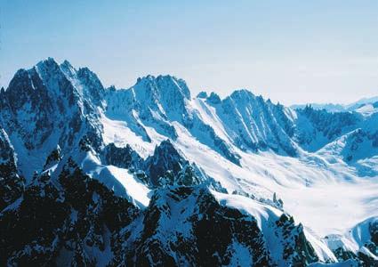
3 M18_TARB6927_09_SE_C18.QXD 1/16/07 4:41 PM Page 484 Climate has a strong influence on the nature and intensity of Earth s external processes. This fact is dramatically illustrated in this chapter because the existence and extent of glaciers is largely controlled by Earth s changing climate. Like the running water and groundwater that were the focus of the preceding two chapters, glaciers represent a significant erosional process. These moving masses of ice are responsible for creating many unique landforms and are part of an important link in the rock cycle in which the products of weathering are transported and deposited as sediment. Today glaciers cover nearly 10 percent of Earth s land surface; however, in the recent geologic past, ice sheets were three times more extensive, covering vast areas with ice thousands of meters thick. Many regions still bear the mark of these glaciers (Figure 18.1). The basic character of such diverse places as the Alps, Cape Cod, and Yosemite Valley was fashioned by now vanished masses of glacial ice. Moreover, Long Island, the Great Lakes, and the fiords of Norway and Alaska all owe their existence to glaciers. Glaciers, of course, are not just a phenomenon of the geologic past. As you will see, they are still sculpting and depositing debris in many regions today. FIGURE 18.1 Glacier National Park, Montana, presents a landscape carved by glaciers. St. Mary Lake occupies a glacially eroded valley (glacial trough) and exists because of glacial deposits that act as a dam. The sharp ridges on the left (arêtes) and the pointed peak in the background (a horn) were also sculptured by glacial ice. (Copyright by Carr Clifton. All rights reserved.)

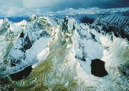
4 M18_TARB6927_09_SE_C18.QXD 1/16/07 4:41 PM Page 485 Glaciers: A Part of Two Basic Cycles 485 Glaciers: A Part of Two Basic Cycles Glaciers and Glaciation Introduction Glaciers are a part of two fundamental cycles in the Earth system the hydrologic cycle and the rock cycle. Earlier you learned that the water of the hydrosphere is constantly cycled through the atmosphere, biosphere, and geosphere. Time and time again, water evaporates from the oceans into the atmosphere, precipitates upon the land, and flows in rivers and underground back to the sea. However, when precipitation falls at high elevations or high latitudes, the water may not immediately make its way toward the sea. Instead, it may become part of a glacier. Although the ice will eventually melt, allowing the water to continue its path to the sea, water can be stored as glacial ice for many tens, hundreds, or even thousands of years. A glacier is a thick ice mass that forms over hundreds or thousands of years. It originates on land from the accumulation, compaction, and recrystallization of snow. A glacier appears to be motionless, but it is not glaciers move very slowly. Like running water, groundwater, wind, and waves, glaciers are dynamic erosional agents that accumulate, transport, and deposit sediment. As such, glaciers are among the processes that perform a basic function in the rock cycle. Although glaciers are found in many parts of the world today, most are located in remote areas, either near Earth s poles or in high mountains. area of the North Pole, Greenland is covered by an imposing ice sheet that occupies 1.7 million square kilometers, or about 80 percent of this large island. Averaging nearly 1500 meters (5000 feet) thick, the ice extends 3000 meters (10,000 feet) above the island s bedrock floor in some places. In the Southern Hemisphere, the huge Antarctic Ice Sheet attains a maximum thickness of about 4300 meters (14,000 feet) and covers nearly the entire continent, an area of more than 13.9 million square kilometers (5.4 million square miles). Because of the proportions of these huge features, they often are called continental ice sheets. Indeed, the combined areas of present-day continental ice sheets represent almost 10 percent of Earth s land area. These enormous masses flow out in all directions from one or more snow-accumulation centers and completely obscure all but the highest areas of underlying terrain. Even sharp variations in the topography beneath the glacier usually appear as relatively subdued undulations on the surface of the ice. Such topographic differences, however, do affect the behavior of the ice sheets, especially near their margins, by guiding flow in certain directions and creating zones of faster and slower movement. FIGURE 18.2 Aerial view of Chigmit Mountains in Lake Clark National Park, Alaska. Valley glaciers continue to modify this landscape. (Photo by Michael Collier) Valley (Alpine) Glaciers Literally thousands of relatively small glaciers exist in lofty mountain areas, where they usually follow valleys that were originally occupied by streams. Unlike the rivers that previously flowed in these valleys, the glaciers advance slowly, perhaps only a few centimeters per day. Because of their setting, these moving ice masses are termed valley glaciers or alpine glaciers (Figure 18.2). Each glacier actually is a stream of ice, bounded by precipitous rock walls, that flows downvalley from an accumulation center near its head. Like rivers, valley glaciers can be long or short, wide or narrow, single or with branching tributaries. Generally, the widths of alpine glaciers are small compared to their lengths. Some extend for just a fraction of a kilometer, whereas others go on for many tens of kilometers. The west branch of the Hubbard Glacier, for example, runs through 112 kilometers (nearly 70 miles) of mountainous terrain in Alaska and the Yukon Territory. Ice Sheets In contrast to valley glaciers, ice sheets exist on a much larger scale. The low total annual solar radiation reaching the poles makes these regions eligible for great ice accumulations. Although many ice sheets have existed in the past, just two achieve this status at present (Figure 18.3). In the


5 M18_TARB6927_09_SE_C18.QXD 1/16/07 4:41 PM Page CHAPTER 18 Glaciers and Glaciation Arctic Circle Ross and Filchner ice shelves are the largest, with the Ross Ice Shelf alone covering an area approximately the size of Texas (Figure 18.3). In recent years, satellite monitoring has shown that some ice shelves are unstable and breaking apart. Box 18.1 explores this topic. Ross Ice Shelf Greenland Filchner Ice Shelf North Pole Antarctic Peninsula South Pole Antarctica Larson B Ice Shelf Weddell Sea Other Types of Glaciers In addition to valley glaciers and ice sheets, other types of glaciers are also identified. Covering some uplands and plateaus are masses of glacial ice called ice caps. Like ice sheets, ice caps completely bury the underlying landscape but are much smaller than the continental-scale features. Ice caps occur in many places, including Iceland and several of the large islands in the Arctic Ocean (Figure 18.4). Often ice caps and ice sheets feed outlet glaciers. These tongues of ice flow down valleys extending outward from the margins of these larger ice masses. The tongues are essentially valley glaciers that are avenues for ice movement from an ice cap or ice sheet through mountainous terrain to the sea. Where they encounter the ocean, some outlet glaciers spread out as floating ice shelves. Often large numbers of icebergs are produced. Piedmont glaciers occupy broad lowlands at the bases of steep mountains and form when one or more alpine glaciers emerge from the confining walls of mountain valleys. Here the advancing ice spreads out to form a broad sheet. The size of individual piedmont glaciers varies greatly. Among the largest is the broad Malaspina Glacier along the coast of southern Alaska. It covers thousands of square kilometers of the flat coastal plain at the foot of the lofty St. Elias range (Figure 18.5). Antarctic Circle FIGURE 18.3 The only present-day continental ice sheets are those covering Greenland and Antarctica. Their combined areas represent almost 10 percent of Earth s land area. Greenland s ice sheet occupies 1.7 million square kilometers, or about 80 percent of the island. The area of the Antarctic Ice Sheet is almost 14 million square kilometers. Ice shelves occupy an additional 1.4 million square kilometers adjacent to the Antarctic Ice Sheet. FIGURE 18.4 The ice cap in this satellite image is the Vantnajükull in southeastern Iceland ( jükull means ice cap in Danish). In 1996 the Grimsvötn Volcano erupted beneath the ice cap, producing large quantities of melted glacial water that created floods. (Landsat image from NASA) Along portions of the Antarctic coast, glacial ice flows into the adjacent ocean, creating features called ice shelves. They are large, relatively flat masses of floating ice that extend seaward from the coast but remain attached to the land along one or more sides. The shelves are thickest on their landward sides, and they become thinner seaward. They are sustained by ice from the adjacent ice sheet as well as being nourished by snowfall and the freezing of seawater to their bases. Antarctica s ice shelves extend over approximately 1.4 million square kilometers (0.6 million square miles). The Grimsvötn Volcano

 wide and extends up to 45 kilometers (28 miles) from the mountain front nearly to the sea.")
6 M18_TARB6927_09_SE_C18.QXD 1/16/07 4:41 PM Page 487 FIGURE 18.5 Malaspina glacier in southeastern Alaska is considered a classic example of a piedmont glacier. Piedmont glaciers occur where valley glaciers exit a mountain range onto broad lowlands, are no longer laterally confined, and spread to become wide lobes. Malaspina Glacier is actually a compound glacier, formed by the merger of several valley glaciers, the most prominent of which seen here are Agassiz Glacier (left) and Seward Glacier (right). In total, Malaspina Glacier is up to 65 kilometers (40 miles) wide and extends up to 45 kilometers (28 miles) from the mountain front nearly to the sea. This perspective view looking north covers an area about 55 kilometers * 55 kilometers 134 * 34 miles2. It was created from a Landsat satellite image and an elevation model generated by the Shuttle Radar Topography Mission (SRTM). Such images are excellent tools for mapping the geographic extent of glaciers and for determining whether such glaciers are thinning or thickening. (Image from NASA/JPL) melts during the summer. Glaciers develop in the high latitude polar realm because, even though annual snowfall totals are modest, temperatures are so low that little of the snow melts. Glaciers can form in mountains because temperatures drop with an increase in altitude. So even near the equator, glaciers may form at elevations above about 5000 meters (16,400 feet). For example, Tanzania s Mount Kilimanjaro, which is located practically astride the equator at an altitude of 5895 meters (19,336 feet), has glaciers at its summit (Figure 18.7). The elevation above which snow remains throughout the year is called the snowline. As you would expect the elevation of the snowline varies with latitude. Near the equator, it occurs high in the mountains, whereas near the 60th parallel it is at sea level. Before a glacier is created, snow must be converted into glacial ice. What if the Ice Melted? How much water is stored as glacial ice? Estimates by the U.S. Geological Survey indicate that only slightly more than 2 percent of the world s water is tied up in glaciers. But even 2 percent of a vast quantity is still large. The total volume of just valley glaciers is about 210,000 cubic kilometers, comparable to the combined volume of the world s largest saline and freshwater lakes. As for ice sheets, Antarctica s represents 80 percent of the world s ice and an estimated 65 percent of Earth s fresh water. It covers an area almost one and a half times the area of the entire United States. If this ice melted, sea level would rise an estimated 60 to 70 meters and the ocean would inundate many densely populated coastal areas (Figure 18.6). The hydrologic importance of the Antarctic ice can be illustrated in another way. If the ice sheet were melted at a uniform rate, it could feed (1) the Mississippi River for more Seattle than 50,000 years, (2) all the rivers in the United States for about 17,000 years, (3) the Amazon River for approximately 5000 years, or (4) all the rivers of the world for about 750 years. Formation and Movement of Glacial Ice Los Angeles San Francisco Glacial Ice Formation When temperatures remain below freezing following a snowfall, the fluffy accumulation of delicate hexagonal crystals soon changes. As air infiltrates the spaces between the crystals, the extremities of the crystals evaporate and the water vapor condenses near the centers of the crystals. In this manner, snowflakes become smaller, thicker, and more spherical, and the large pore spaces disappear. By this process air is forced out and what was once light, fluffy snow is recrystallized into a much denser mass of small grains having the consistency of coarse sand. This granular Phoenix Coastline if present ice sheets melt Houston Memphis Charleston Orlando New York Coastline 18,000 years ago Glaciers and Glaciation Budget of a Glacier Snow is the raw material from which glacial ice originates; therefore, glaciers form in areas where more snow falls in winter than FIGURE 18.6 This map of a portion of North America shows the present-day coastline compared to the coastline that existed during the last ice age (18,000 years ago) and the coastline that would exist if present ice sheets on Greenland and Antarctica melted. (After R. H. Dott, Jr., and R. L. Battan, Evolution of the Earth, New York: McGraw Hill, Reprinted by permission of the publisher.) 487

. The event sent thousands of icebergs adrift in the adjacent Weddell Sea (see Figure 18.3). In all, about 3250 square kilometers (1250 square miles) FIGURE 18.")
7 M18_TARB6927_09_SE_C18.QXD 1/16/07 4:41 PM Page CHAPTER 18 Glaciers and Glaciation BOX 18.1 UNDERSTANDING EARTH The Collapse of Antarctic Ice Shelves Studies using recent satellite imagery show that portions of some ice shelves are breaking apart. For example, during a 35- day span in February and March 2002 an ice shelf on the eastern side of the Antarctic Peninsula, known as the Larsen B ice shelf, broke apart and separated from the continent (Figure 18.A). The event sent thousands of icebergs adrift in the adjacent Weddell Sea (see Figure 18.3). In all, about 3250 square kilometers (1250 square miles) FIGURE 18.A This satellite image shows the Larsen B ice shelf during its collapse in early (Image courtesy of NASA) of the ice shelf broke apart. (For reference, the entire state of Rhode Island covers 2717 square kilometers.) This was not an isolated event but part of a trend. Over a fiveyear span, the Larsen B ice shelf shrank by 5700 square kilometers (more than 2200 square miles). Moreover, since 1974 the extent of seven ice shelves surrounding the Antarctic Peninsula declined by about 13,500 square kilometers (nearly 5300 square miles). Why did these masses of floating ice break apart? What if the trend continues? Could there be any serious consequences? Scientists attribute the breakup of the ice shelves to a strong regional climate warming. Since about 1950, Antarctic temperatures have risen by 2.5 C (4.5 F). The rate of warming has been about 0.5 C (nearly 1 F) per decade. If temperatures continue to rise, an ice shelf adjacent to Larsen B may start to recede in coming decades. Moreover, regional warming of just a few degrees Celsius may be sufficient to cause portions of the huge Ross Ice Shelf to become unstable and begin to break apart (see Figure 18.3). What might the consequences be? Scientists at the National Snow and Ice Data Center (NSIDC) suggest the following: While the breakup of the ice shelves in the Peninsula has little consequence for sea level rise, the breakup of other shelves in the Antarctic could have a major effect on the rate of ice flow off the continent. Ice shelves act as a buttress, or braking system, for glaciers. Further, the shelves keep warmer marine air at a distance from the glaciers; therefore, they moderate the amount of melting that occurs on the glaciers surfaces. Once their ice shelves are removed, the glaciers increase in speed due to meltwater percolation and/or a reduction of braking forces, and they may begin to dump more ice into the ocean. Glacier ice speed increases are already observed in Peninsula areas where ice shelves disintegrated in prior years.* The addition of large quantities of glacial ice to the ocean could indeed cause a significant rise in sea level. Remember that what is being suggested here is still speculative because our knowledge of the dynamics of Antarctica s ice shelves and glaciers is incomplete. Additional satellite monitoring and field studies will be necessary if we are to more accurately predict potential rises in global sea level triggered by the mechanism described here. *National Snow and Ice Data Center, Antarctic Ice- Shelf Collapses, 21 March 2002, iceshelves/larsenb2002. FIGURE 18.7 Mount Kilimanjaro, the highest peak in Africa, is capped by small alpine glaciers. (Photo by Ulrich Doering/Alamy) recrystallized snow is called firn and is commonly found making up old snowbanks near the end of winter. As more snow is added, the pressure on the lower layers gradually increases, compacting the ice grains at depth. Once the thickness of ice and snow exceeds 50 meters (160 feet), the weight is sufficient to fuse firn into a solid mass of interlocking ice crystals. Glacial ice has now been formed. The rate at which this transformation occurs varies. In regions where the annual snow accumulation is great, burial is relatively rapid and snow may turn to glacial ice in a matter of a decade or less. Where the yearly addition of snow is less abundant, burial is slow and the transformation of snow to glacial ice may take hundreds of years.

8 M18_TARB6927_09_SE_C18.QXD 1/16/07 4:41 PM Page 489 Formation and Movement of Glacial Ice 489 Students Sometimes Ask... In chapter 8 you said that glacial ice is a metamorphic rock which makes it part of the geosphere. Glacial ice is also a part of the hydrologic cycle, so is it considered part of the hydrosphere, too? Yes, it s okay to place ice in both spheres. Moreover, scientists also place ice in its own sphere the cryosphere. The word comes from the Greek word kryos, meaning frost or icy cold. Cryosphere refers to that portion of Earth s surface where water is in a solid form. This includes snow, glaciers, sea ice, freshwater ice, and frozen ground (permafrost). Total movement Sliding Internal flow Bedrock Zone of fracture Movement of a Glacier The movement of glacial ice is generally referred to as flow. The fact that glacial movement is described in this way seems paradoxical how can a solid flow? The way in which ice flows is complex and is of two basic types. The first of these, plastic flow, involves movement within the ice. Ice behaves as a brittle solid until the pressure upon it is equivalent to the weight of about 50 meters (165 feet) of ice. Once that load is surpassed, ice behaves as a plastic material and flow begins. Such flow occurs because of the molecular structure of ice. Glacial ice consists of layers of molecules stacked one upon the other. The bonds between layers are weaker than those within each layer. Therefore, when a stress exceeds the strength of the bonds between the layers, the layers remain intact and slide over one another. A second and often equally important mechanism of glacial movement consists of the entire ice mass slipping along the ground. With the exception of some glaciers located in polar regions where the ice is probably frozen to the solid bedrock floor, most glaciers are thought to move by this sliding process, called basal slip. In this process, meltwater probably acts as a hydraulic jack and perhaps as a lubricant helping the ice over the rock. The source of the liquid water is related in part to the fact that the melting point of ice decreases as pressure increases. Therefore, deep within a glacier the ice may be at the melting point even though its temperature is below 0 C. In addition, other factors may contribute to the presence of meltwater deep within the glacier. Temperatures may be increased by plastic flow (an effect similar to frictional heating), by heat added from the Earth below, and by the refreezing of meltwater that has seeped down from above. This last process relies on the property that as water changes state from liquid to solid, heat (termed latent heat of fusion) is released. Figure 18.8 illustrates the effects of these two basic types of glacial motion. This vertical profile through a glacier also shows that not all the ice flows forward at the same rate. Frictional drag with the bedrock floor causes the lower portions of the glacier to move more slowly. FIGURE 18.8 Vertical cross section through a glacier to illustrate ice movement. Glacial movement is divided into two components. Below about 50 meters (160 feet), ice behaves plastically and flows. In addition, the entire mass of ice may slide along the ground. The ice in the zone of fracture is carried along piggyback style. Notice that the rate of movement is slowest at the base of the glacier, where frictional drag is greatest. In contrast to the lower portion of the glacier, the upper 50 meters or so are not under sufficient pressure to exhibit plastic flow. Rather, the ice in this uppermost zone is brittle and is appropriately referred to as the zone of fracture. The ice in the zone of fracture is carried along piggyback style by the ice below. When the glacier moves over irregular terrain, the zone of fracture is subjected to tension, resulting in cracks called crevasses (Figure 18.9). These gaping cracks can make travel across glaciers dangerous and may extend to depths of 50 meters. Below this depth, plastic flow seals them off. Students Sometimes Ask... I ve heard that icebergs might be used as a source of water in deserts. Is that possible? It is true that people in arid lands have seriously studied the possibility of towing icebergs from Antarctica to serve as a source of fresh water. There are certainly ample supplies. Each year, in the waters surrounding Antarctica, about 1000 cubic kilometers (240 cubic miles) of glacial ice breaks off and creates icebergs. However, there are significant technological problems that are not likely to be overcome soon. For instance, vessels capable of towing huge icebergs (1 to 2 kilometers across) have not yet been developed. In addition, there would be a substantial loss of ice to melting and evaporation that would take place as an iceberg is slowly rafted (for up to one year) through warm ocean waters.

9 M18_TARB6927_09_SE_C18.QXD 1/16/07 4:41 PM Page 490 so slowly that trees and other vegetation may become well established in the debris that has accumulated on the glacier s surface, whereas others may move at rates of up to several meters per day. For example, Byrd Glacier, an outlet glacier in Antarctica that was the subject of a 10-year study using satellite images, moved at an average rate of 750 to 800 meters per year (about 2 meters per day). Other glaciers in the study advanced at one-fourth that rate. The advance of some glaciers is characterized by periods of extremely rapid movements called surges. Glaciers that exhibit such movement may flow along in an apparently normal manner, then speed up for a relatively short time before returning to the normal rate again. The flow rates during surges are as much as 100 times the normal rate. Evidence indicates that many glaciers may be of the surging type. It is not yet clear whether the mechanism that triggers these rapid movements is the same for each surging-type glacier. However, researchers studying the Variegated Glacier shown in Figure have determined that the surges of this ice mass take the form of a rapid increase in basal sliding that is caused by increases in water pressure beneath the ice. The increased water pressure at the base of the glacier acts to reduce friction between the underlying bedrock and the moving ice. The pressure buildup, in turn, is related to changes in the system of passageways that conduct water along the glacier s bed and deliver it as outflow to the terminus. FIGURE 18.9 Crevasses form in the brittle ice of the zone of fracture. They can extend to depths of 50 meters and can obviously make travel across glaciers dangerous. Gasherbrum II expedition, Pakistan. (Photo by Galen Rowell/Mountain Light Photography, Inc.) Rates of Glacial Movement Unlike streamflow, glacial movement is not obvious. If we could watch an alpine glacier move, we would see that like the water in a river, all of the ice in the valley does not move at an equal rate. Just as friction with the valley floor slows the movement of the ice at the bottom of the glacier, the drag created by the valley walls causes the rate of flow to be greatest in the center of the glacier. This was first demonstrated by experiments during the nineteenth century, in which markers were carefully placed in a straight line across the top of a valley glacier. Periodically, the positions of the stakes were recorded, revealing the type of movement just described. More about these experiments may be found in Box 1.2 on page 13. How rapidly does glacial ice move? Average velocities vary considerably from one glacier to another. Some move 490 Budget of a Glacier Snow is the raw material from which glacial ice originates; therefore, glaciers form in areas where more snow falls in winter than melts during the summer. Glaciers are constantly gaining and losing ice. Snow accumulation and ice formation occur in the zone of accumulation. Its outer limits are defined by the snowline. As noted earlier, the elevation of the snowline varies greatly, from sea level in polar regions to altitudes approaching 5000 meters near the equator. Above the snowline, in the zone of accumulation, the addition of snow thickens the glacier and promotes movement. Beyond the snowline is the zone of wastage. Here there is a net loss to the glacier as all of the snow from the previous winter melts, as does some of the glacial ice (Figure 18.11). In addition to melting, glaciers also waste as large pieces of ice break off the front of the glacier in a process called calving. Calving creates icebergs in places where the glacier has reached the sea or a lake (Figure 18.12). Because icebergs are just slightly less dense than seawater, they float very low in the water, with more than 80 percent of their mass submerged. Along the margins of Antarctica s ice shelves, calving is the primary means by which these masses lose ice. The relatively flat icebergs produced here can be several kilometers across and 600 meters thick. By comparison, thousands of irregularly shaped icebergs are produced by outlet glaciers flowing from the margins of the Greenland Ice Sheet. Many drift southward and find their way into the North Atlantic, where they can pose a hazard to navigation.

 Whether the margin of a glacier is advancing, retreating, or remaining stationary depends on the budget of the glacier.")

10 M18_TARB6927_09_SE_C18.QXD 1/16/07 4:41 PM Page 491 Formation and Movement of Glacial Ice 491 August 1964 August 1965 Position before surge Position before surge Position after surge FIGURE The surge of Variegated Glacier, a valley glacier near Yakutat, Alaska, northwest of Juneau is captured in these two aerial photographs taken one year apart. During a surge, ice velocities in Variegated Glacier are 20 to 50 times greater than during a quiescent phase. (Photos by Austin Post, U.S. Geological Survey) Whether the margin of a glacier is advancing, retreating, or remaining stationary depends on the budget of the glacier. The glacial budget is the balance, or lack of balance, between accumulation at the upper end of the glacier and loss at the lower end. This loss is termed ablation. If ice accumulation exceeds ablation, the glacial front advances until the two factors balance. When this happens, the terminus of the glacier becomes stationary. If a warming trend increases ablation and/or if a drop in snowfall decreases accumulation, the ice front will retreat. Zone of accumulation Snowline Crevasses Zone of wastage Iceberg formed by calving FIGURE The snowline separates the zone of accumulation and the zone of wastage. Above the snowline, more snow falls each winter than melts each summer. Below the snowline, the snow from the previous winter completely melts as does some of the underlying ice. Whether the margin of a glacier advances, retreats, or remains stationary depends on the balance between accumulation and wastage (ablation). When a glacier moves across irregular terrain, crevasses form in the brittle portion.


11 M18_TARB6927_09_SE_C18.QXD 1/16/07 4:42 PM Page 492 FIGURE Icebergs are created when large pieces calve from the front of a glacier after it reaches a water body. Here ice is calving from the terminus of Alaska s Hubbard Glacier in Wrangell St. Elias National Park, Alaska. Only about 20 percent of an iceberg protrudes above the water line. (Photo by Tom & Susan Bean, Inc.) As the terminus of the glacier retreats, the extent of the zone of wastage diminishes. Therefore, in time a new balance will be reached between accumulation and wastage, and the ice front will again become stationary. Whether the margin of a glacier is advancing, retreating, or stationary, the ice within the glacier continues to flow forward. In the case of a receding glacier, the ice still flows forward, but not rapidly enough to offset ablation. This point is illustrated well in Figure 1.C on page 13. As the line of stakes within Rhône Glacier continued to move downvalley, the terminus of the glacier slowly retreated upvalley. Glacial Erosion Glaciers are capable of great erosion. For anyone who has observed the terminus of an alpine glacier, the evidence of its erosive force is clear. You can witness firsthand the release of rock material of various sizes from the ice as it melts. All signs lead to the conclusion that the ice has scraped, scoured, and torn rock from the floor and walls of the valley and carried it downvalley. It should be pointed out, however, that in mountainous regions mass-wasting processes also make substantial contributions to the sediment load of a glacier. A glance back at Figure on page 410 provides a striking example. The image shows a 4-kilometer-long tongue of rock avalanche debris deposited atop Alaska s Sherman Glacier. Once rock debris is acquired by the glacier, the enormous competency of ice will not allow the debris to settle out like the load carried by a stream or by the wind. Indeed, as a medium of sediment transport, ice has no equal. Consequently, glaciers can carry huge blocks that no other erosional agent could possibly budge (Figure 18.13). Although today s glaciers are of limited importance as erosional agents, many landscapes that were modified by the widespread glaciers of the most recent Ice Age still reflect to a high degree the work of ice. 492 Glaciers erode the land primarily in two ways plucking and abrasion. First, as a glacier flows over a fractured bedrock surface, it loosens and lifts blocks of rock and incorporates them into the ice. This process, known as plucking, occurs when meltwater penetrates the cracks and joints of bedrock beneath a glacier and freezes. As the water expands, it exerts tremendous leverage that pries the rock loose. In this manner, sediment of all sizes becomes part of the glacier s load. The second major erosional process is abrasion (Figure 18.14). As the ice and its load of rock fragments slide over bedrock, they function like sandpaper to smooth and polish the surface below. The pulverized rock produced by the glacial grist mill is appropriately called rock flour. So much rock flour may be produced that meltwater streams flowing out of a glacier often have the grayish appearance of skim milk and offer visible evidence of the grinding power of ice. When the ice at the bottom of a glacier contains large rock fragments, long scratches and grooves called glacial striations may even be gouged into the bedrock (Figure 18.14A). These linear grooves provide clues to the direction of ice flow. By mapping the striations over large areas, patterns of glacial flow can often be reconstructed. On the other hand, not all abrasive action produces striations. The rock surfaces over which the glacier moves may also become highly polished by the ice and its load of finer particles. The broad expanses of smoothly polished granite in Yosemite National Park provide an excellent example (Figure 18.14B). As is the case with other agents of erosion, the rate of glacial erosion is highly variable. This differential erosion by ice is largely controlled by four factors: (1) rate of glacial movement; (2) thickness of the ice; (3) shape, abundance, and hardness of the rock fragments contained in the ice at FIGURE A large, glacially transported boulder in central Wyoming. Such boulders are called glacial erratics. (Photo by Yva Momatiuk and John Eastcott/Photo Researchers, Inc.)

.")
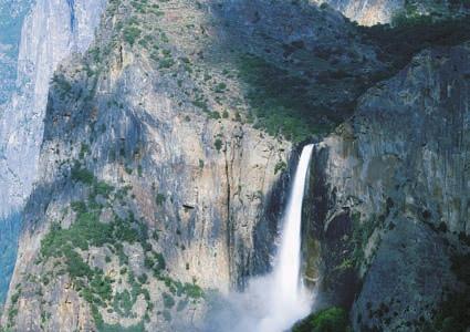
12 M18_TARB6927_09_SE_C18.QXD 1/16/07 4:42 PM Page 493 the base of the glacier; and (4) the erodibility of the surface beneath the glacier. Variations in any or all of these factors from time to time and/or from place to place mean that the features, effects, and degree of landscape modification in glaciated regions can vary greatly. Landforms Created by Glacial Erosion Glaciers and Glaciation Reviewing Glacial Features The erosional effects of valley glaciers and ice sheets are quite different. A visitor to a glaciated mountain region is likely to see a sharp and angular topography (see Figure 18.1, p. 484). The reason is that as alpine glaciers move downvalley, they tend to accentuate the irregularities of the mountain landscape by creating steeper canyon walls and making bold peaks even more jagged. By contrast, continental ice sheets generally override the terrain and hence subdue rather than accentuate the irregularities they encounter. Although the erosional potential of ice sheets is enormous, landforms carved by these huge ice masses usually do not inspire the same wonderment and awe as do the erosional features created by valley glaciers. Much of the rugged mountain scenery so celebrated for its majestic beauty is the product of erosion by alpine glaciers. Figure shows a hypothetical mountain area before, during, and after glaciation. Glaciated Valleys A hike up a glaciated valley reveals a number of striking icecreated features. The valley itself is often a dramatic sight. Unlike streams, which create their own valleys, glaciers take the path of least resistance by following the course of existing stream valleys. Prior to glaciation, mountain valleys are characteristically narrow and V-shaped because streams are well above base level and are therefore downcutting. However, during glaciation these narrow valleys undergo a transformation as the glacier widens and deepens them, creating a U-shaped glacial trough (Figure 18.15). In addition to producing a broader and deeper valley, the glacier also straightens the valley. As ice flows around sharp curves, its great erosional force removes the spurs of land that extend into the valley. The results of this activity are triangularshaped cliffs called truncated spurs (Figure 18.15). The amount of glacial erosion that takes place in different valleys in a mountainous area varies. Prior to glaciation, the mouths of tributary streams join the main (trunk) valley at the elevation of the stream in that valley. During glaciation, the amount of ice flowing through the main valley can be much greater than the amount advancing down each tributary. Consequently, the valley containing the trunk glacier is eroded deeper than the smaller valleys that feed it. Thus, when the glaciers eventually recede, the valleys of tributary glaciers are left standing above the main glacial trough and are termed hanging valleys (Figure 18.15). Rivers flowing A. B. FIGURE A. Glacial abrasion created the scratches and grooves in this bedrock. Glacier Bay National Park, Alaska. (Photo copyright Carr Clifton. All rights reserved.) B. Glacially polished granite in California s Yosemite National Park. (Photo by E. J. Tarbuck) through hanging valleys may produce spectacular waterfalls, such as those in Yosemite National Park (Figure 18.15). As hikers walk up a glacial trough, they may pass a series of bedrock depressions on the valley floor that were probably created by plucking and then scoured by the abrasive force of the ice. If these depressions are filled with water, they are called pater noster lakes (Figure 18.15). The Latin name means our Father and is a reference to a string of rosary beads. At the head of a glacial valley is a very characteristic and often imposing feature called a cirque. As the photo in Figure illustrates, these bowl-shaped depressions have precipitous walls on three sides but are open on the downvalley side. The cirque is the focal point of the glacier s growth because it is the area of snow accumulation and ice formation. Cirques begin as irregularities in the mountainside that are subsequently enlarged by the frost wedging and plucking that occur along the sides and bottom of the 493


13 M18_TARB6927_09_SE_C18.QXD 1/16/07 4:42 PM Page CHAPTER 18 Glaciers and Glaciation V-shaped valley A. Unglaciated topography Horn Arête Medial moraine Main glacier Truncated spur B. Region during period of maximum glaciation Cirques FIGURE Prior to glaciation, a mountain valley is typically narrow and V-shaped. During glaciation, an alpine glacier widens, deepens, and straightens the valley, creating a U-shaped glacial trough. These diagrams of a hypothetical area show the development of erosional landforms created by alpine glaciers. The unglaciated landscape in part A is modified by valley glaciers in part B. After the ice recedes, in part C, the terrain looks very different than before glaciation. (Cirque photo by Marli Miller, horn photo by Gavriel Jecan, glacial trough photo by John Montagne, hanging valley photo by Marc Muench, tarn photo by Stephen J. Krasemann, arête photo by James E. Patterson)


14 M18_TARB6927_09_SE_C18.QXD 1/16/07 4:42 PM Page 495 Landforms Created by Glacial Erosion 495 Horn Tarn Arête Cirques Pater noster lakes C. Glaciated topography Hanging valley Glacial trough FIGURE (Continued)
.")

15 M18_TARB6927_09_SE_C18.QXD 1/16/07 4:42 PM Page CHAPTER 18 Glaciers and Glaciation glacier. After the glacier has melted away, the cirque basin is often occupied by a small lake called a tarn (Figure 18.15). Sometimes when two glaciers exist on opposite sides of a divide, each flowing away from the other, the dividing ridge between their cirques is largely eliminated as plucking and frost action enlarge each one. When this occurs, the two glacial troughs come to intersect, creating a gap or pass from one valley into the other. Such a feature is termed a col. Some important and well-known mountain passes that are cols include St. Gotthard Pass in the Swiss Alps, Tioga Pass in California s Sierra Nevada, and Berthoud Pass in the Colorado Rockies. Before leaving the topic of glacial troughs and their associated features, one more rather well-known feature should be discussed: fiords. Fiords are deep, often spectacular steep-sided inlets of the sea that are present at high latitudes where mountains are adjacent to the ocean (Figure 18.16). They are drowned glacial troughs that became submerged as the ice left the valley and sea level rose following the Ice Age. The depths of fiords may exceed 1000 meters (3300 feet). However, the great depths of these flooded troughs are only partly explained by the post Ice Age rise in sea level. Unlike the situation governing the downward erosional work of rivers, sea level does not act as base level for glaciers. As a consequence, glaciers are capable of eroding their beds far below the surface of the sea. For example, a 300-meter-thick (1000-foot-thick) glacier can carve its valley floor more than 250 meters (820 feet) below sea level before downward erosion ceases and the ice begins to float. Norway, British Columbia, Greenland, New Zealand, Chile, and Alaska all have coastlines characterized by fiords. Arêtes and Horns A visit to the Alps and the Northern Rockies, or many other scenic mountain landscapes carved by valley glaciers, reveals not only glacial troughs, cirques, pater noster lakes, and the other related features just discussed. You also are likely to see sinuous sharp-edged ridges called arêtes (French for knife-edge) and sharp pyramid-like peaks called horns projecting above the surroundings. Both features can originate from the same basic process, the enlargement of cirques produced by plucking and frost action (Figure 18.15). In the case of the spires of rock called horns, groups of cirques around a single high mountain are responsible. As the cirques enlarge and converge, an isolated horn is produced. The most famous example is the Matterhorn in the Swiss Alps (Figure 18.15). Arêtes can be formed in a similar manner, except that the cirques are not clustered around a point but rather exist on opposite sides of a divide. As the cirques grow, the divide separating them is reduced to a narrow knifelike partition. An arête, however, may also be created in another way. When two glaciers occupy parallel valleys, an arête can form when the divide separating the moving tongues of ice is progressively narrowed as the glaciers scour and widen their adjacent valleys. Roches Moutonnées In many glaciated landscapes, but most frequently where continental ice sheets have modified the terrain, the ice carves small streamlined hills from protruding bedrock Alaska Canada Gulf of Alaska Juneau Sitka Tracy Arm Stephens Passage FIGURE Like other fiords, this one at Tracy Arm, Alaska, is a drowned glacial trough. (Photo by Tom & Susan Bean, Inc.)
 knobs.")
16 M18_TARB6927_09_SE_C18.QXD 1/16/07 4:42 PM Page 497 Landforms Made of Till 497 FIGURE Roche Moutonnée, in Yosemite National Park, California. The gentle slope was abraded and the steep side was plucked. The ice moved from right to left. (Photo by E. J. Tarbuck) knobs. Such an asymmetrical knob of bedrock is called a roche moutonnée (French for sheep rock). They are formed when glacial abrasion smoothes the gentle slope facing the oncoming ice sheet and plucking steepens the opposite side as the ice rides over the knob (Figure 18.17). Roches moutonnées indicate the direction of glacial flow because the gentler slope is generally on the side from which the ice advanced. Glacial Deposits Glaciers and Glaciation Reviewing Glacial Features Ice flow Glacial plucking Bedrock Glacial abrasion Glaciers pick up and transport a huge load of debris as they slowly advance across the land. Ultimately these materials are deposited when the ice melts. In regions where glacial sediment is deposited, it can play a truly significant role in forming the physical landscape. For example, in many areas once covered by the continental ice sheets of the recent Ice Age, the bedrock is rarely exposed because glacial deposits that are tens or even hundreds of meters thick completely mantle the terrain. The general effect of these deposits is to reduce the local relief and thus level the topography. Indeed, rural country scenes that are familiar to many of us rocky pastures in New England, wheat fields in the Dakotas, rolling farmland in the Midwest result directly from glacial deposition. Long before the theory of an extensive Ice Age was ever proposed, much of the soil and rock debris covering portions of Europe was recognized as coming from somewhere else. At the time, these foreign materials were believed to have been drifted into their present positions by floating ice during an ancient flood. As a consequence, the term drift was applied to this sediment. Although rooted in an incorrect concept, this term was so well established by the time the true glacial origin of the debris became widely recognized that it remained in the basic glacial vocabulary. Today glacial drift is an all-embracing term for sediments of glacial origin, no matter how, where, or in what shape they were deposited. One of the features distinguishing drift from sediments laid down by other erosional agents is that glacial deposits consist primarily of mechanically weathered rock debris that underwent little or no chemical weathering prior to deposition. Thus, minerals that are notably prone to chemical decomposition, such as hornblende and the plagioclase feldspars, are often conspicuous components in glacial sediments. Glacial drift is divided by geologists into two distinct types: (1) materials deposited directly by the glacier, which are known as till, and (2) sediments laid down by glacial meltwater, called stratified drift. We will now look at landforms made of each type. Landforms Made of Till Till is deposited as glacial ice melts and drops its load of rock fragments. Unlike moving water and wind, ice cannot sort the sediment it carries; therefore, deposits of till are characteristically unsorted mixtures of many particle sizes (Figure 18.18). A close examination of this sediment shows that many of the pieces are scratched and polished as the result of being dragged along by the glacier. Such pieces help distinguish till from other deposits that are a mixture of different sediment sizes, such as material from a debris flow or a rockslide. Boulders found in the till or lying free on the surface are called glacial erratics if they are different from the bedrock below (see Figure 18.13, p. 492). Of course, this means that they must have been derived from a source outside the area where they are found. Although the locality of origin for most erratics is unknown, the origin of some can be determined. In many cases, boulders were transported as far as 500 kilometers (300 miles) from their source area and, in a few instances, more than 1000 kilometers (600 miles). Therefore, by studying glacial erratics as well as the mineral composition of the remaining till, geologists are sometimes able to trace the path of a lobe of ice. In portions of New England and other areas, erratics dot pastures and farm fields. In fact, in some places these large rocks were cleared from fields and piled to make fences and walls (Figure 18.19). Keeping the fields clear, however, is an ongoing chore because each spring newly exposed erratics appear. Wintertime frost heaving has lifted them to the surface.
 Alps. Today, however, moraine has a broader meaning, because it is applied to a number of landforms, all of which are composed primarily of till.")


17 M18_TARB6927_09_SE_C18.QXD 1/16/07 4:42 PM Page 498 FIGURE Land cleared of glacial erratics, which were then piled atop one another to build this stone wall near West Bend, Wisconsin. (Photo by Tom Bean) Alps. Today, however, moraine has a broader meaning, because it is applied to a number of landforms, all of which are composed primarily of till. Alpine glaciers produce two types of moraines that occur exclusively in mountain valleys. The first of these is called a lateral moraine (Figure 18.20). As we learned earlier, when an alpine glacier moves downvalley, the ice erodes the sides of the valley with great efficiency. In addition, large quantities of debris are added to the glacier s surface as rubble falls or slides from higher up on the valley walls and collects on the edges of the moving ice. When the ice eventually melts, this accumulation of debris is dropped next to the valley walls. These ridges of till paralleling the sides of the valley constitute the lateral moraines. FIGURE Well-developed lateral moraines deposited by the shrinking Athabaska Glacier in Canada s Jasper National Park. (Photo by David Barnes/The Stock Market) Close up of cobble FIGURE Glacial till is an unsorted mixture of many different sediment sizes. A close examination often reveals cobbles that have been scratched as they were dragged along by the glacier. (Photos by E. J. Tarbuck) Lateral and Medial Moraines The most common term for landforms made of glacial deposits is moraine. Originally this term was used by French peasants when referring to the ridges and embankments of rock debris found near the margins of glaciers in the French 498
 The second type of moraine that is unique to alpine glaciers is the medial moraine (Figure 18.21).")

18 M18_TARB6927_09_SE_C18.QXD 1/16/07 4:42 PM Page 499 Landforms Made of Till 499 FIGURE Medial moraines form when the lateral moraines of merging valley glaciers join. Saint Elias National Park, Alaska. (Photo by Tom Bean) The second type of moraine that is unique to alpine glaciers is the medial moraine (Figure 18.21). Medial moraines are created when two alpine glaciers coalesce to form a single ice stream. The till that was once carried along the sides of each glacier joins to form a single dark stripe of debris within the newly enlarged glacier. The creation of these dark stripes within the ice stream is one obvious proof that glacial ice moves, because the moraine could not form if the ice did not flow downvalley. It is quite common to see several medial moraines within a single large alpine glacier, because a streak will form whenever a tributary glacier joins the main valley. conveyor-belt action of the glacier continues to provide fresh supplies of sediment to the terminus. In this manner a large quantity of till is deposited as the ice melts away, creating a rock- strewn, undulating plain. This gently rolling layer of till deposited as the ice front recedes is termed ground moraine. Ground moraine has a leveling effect, filling in low spots and clogging old stream channels, often leading to a derangement of the existing drainage system. In areas where this layer of till is still relatively fresh, such as the northern Great Lakes region, poorly drained swampy lands are quite common. Periodically, a glacier will retreat to a point where ablation and nourishment once again balance. When this happens, the ice front stabilizes and a new end moraine forms. The pattern of end moraine formation and ground moraine deposition may be repeated many times before the glacier has completely vanished. Such a pattern is illustrated by Figure It should be pointed out that the outermost end moraine marks the limit of the glacial advance. Because of its special status, this end moraine is also called the terminal moraine. On the other hand, the end moraines that were created as the ice front occasionally stabilized during retreat are termed recessional moraines. Note that both terminal and recessional moraines are essentially alike; the only difference between them is their relative positions. End moraines deposited by the most recent major stage of Ice Age glaciation are prominent features in many parts of the Midwest and Northeast. In Wisconsin the wooded, hilly End and Ground Moraines An end moraine is a ridge of till that forms at the terminus of a glacier. These relatively common landforms are deposited when a state of equilibrium is attained between ablation and ice accumulation. That is, the end moraine forms when the ice is melting and evaporating near the end of the glacier at a rate equal to the forward advance of the glacier from its region of nourishment. Although the terminus of the glacier is now stationary, the ice continues to flow forward, delivering a continuous supply of sediment in the same manner a conveyor belt delivers goods to the end of a production line. As the ice melts, the till is dropped and the end moraine grows. The longer the ice front remains stable, the larger the ridge of till will become. Eventually the time comes when ablation exceeds nourishment. At this point, the front of the glacier begins to recede in the direction from which it originally advanced. However, as the ice front retreats, the Extent of Illinoian glaciation Driftless area End moraines: Wisconsinan Age End moraines: Illinoian Age mi km Extent of Wisconsinan glaciation FIGURE End moraines of the Great Lakes region. Those deposited during the most recent (Wisconsinan) stage are most prominent.

19 M18_TARB6927_09_SE_C18.QXD 1/16/07 4:42 PM Page CHAPTER 18 Glaciers and Glaciation terrain of the Kettle Moraine near Milwaukee is a particularly picturesque example. A well-known example in the Northeast is Long Island. This linear strip of glacial sediment that extends northeastward from New York City is part of an end moraine complex that stretches from eastern Pennsylvania to Cape Cod, Massachusetts (Figure 18.23). The end moraines that make up Long Island represent materials that were deposited by a continental ice sheet in the relatively shallow waters off the coast and built up many meters above sea level. Long Island Sound, the narrow body of water separating the island and the mainland, was not built up as much by glacial deposition and was therefore subsequently flooded by the rising sea following the Ice Age. Figure represents a hypothetical area during glaciation and following the retreat of ice sheets. It shows the moraines that were described in this section, as well as the depositional features that are discussed in the sections that follow. This figure depicts landscape features similar to what might be encountered if you were traveling in the upper Midwest or New England. As you read upcoming sections dealing with other glacial deposits, you will be referred to this figure several times. Drumlins Moraines are not the only landforms deposited by glaciers. In some areas that were once covered by continental ice sheets, a special variety of glacial landscape exists one characterized by smooth, elongate, parallel hills called drumlins (Figure 18.24). Certainly one of the best-known drumlins is Bunker Hill in Boston, the site of the famous Revolutionary War battle in An examination of Bunker Hill or other less famous drumlins would reveal that drumlins are streamlined asymmetrical hills composed largely of till. They range in height from about 15 to 50 meters and may be up to 1 kilometer long. The steep side of the hill faces the direction from which the ice advanced, whereas the gentler, longer slope points in the direction the ice moved. Drumlins are not found as isolated landforms but rather occur in clusters called drumlin fields (Figure 18.25). One such cluster, east of Rochester, New York, is estimated to contain about 10,000 drumlins. Although drumlin formation is not fully understood, their streamlined shape indicates that they were molded in the zone of plastic flow within an active glacier. It is believed that many drumlins originate when glaciers advance over previously deposited drift and reshape the material. Landforms Made of Stratified Drift As the name implies, stratified drift is sorted according to the size and weight of the particles. Because ice is not capable of such sorting activity, these materials are not deposited directly by the glacier as till is, but instead reflect the sorting action of glacial meltwater. Accumulations of stratified drift often consist largely of sand and gravel that is, bed-load material because the finer rock flour remains suspended and therefore is commonly carried far from the glacier by the meltwater streams. Outwash Plains and Valley Trains At the same time that an end moraine is forming, water from the melting glacier cascades over the till, sweeping some of it out in front of the growing ridge of unsorted debris. Meltwater generally emerges from the ice in rapidly moving streams that are often choked with suspended material and carry a substantial bed load as well. As the water leaves the glacier, it moves onto the relatively flat surface beyond and rapidly Students Sometimes Ask... Are any glacial deposits valuable? Yes. In glaciated regions, landforms made of stratified drift, such as eskers, are often excellent sources of sand and gravel. Although the value per ton is low, huge quantities of these materials are used in the construction industry. In addition, glacial sands and gravels are valuable because they make excellent aquifers and thus are significant sources of groundwater in some areas. Clays from former glacial lakes have been used in the manufacture of bricks. Cape Cod FIGURE End moraines make up substantial parts of Long Island, Cape Cod, Martha s Vineyard, and Nantucket. Although portions are submerged, the Ronkonkoma moraine (a terminal moraine) extends through central Long Island, Martha s Vineyard, and Nantucket. It was deposited about 20,000 years ago. The recessional Harbor Hill moraine, which formed about 14,000 years ago, extends along the north shore of Long Island, through southern Rhode Island and Cape Cod.
 loses velocity.")
20 M18_TARB6927_09_SE_C18.QXD 1/16/07 4:42 PM Page 501 Landforms Made of Stratified Drift 501 FIGURE This hypothetical area illustrates many common depositional landforms. (Drumlin photo courtesy of Ward s Natural Science Establishment; kame, esker, and kettle photos by Richard R. Jacobs/JLM Visuals) loses velocity. As a consequence, much of its bed load is dropped and the meltwater begins weaving a complex pattern of braided channels (Figure 18.24). In this way, a broad, ramplike surface composed of stratified drift is built adjacent to the downstream edge of most end moraines. When the feature is formed in association with an ice sheet, it is termed an outwash plain, and when largely confined to a mountain valley, it is usually referred to as a valley train. Outwash plains and valley trains often are pockmarked with basins or depressions known as kettles (Figure 18.24). Kettles also occur in deposits of till. Kettles are formed when blocks of stagnant ice become wholly or partly buried in drift and eventually melt, leaving pits in the glacial sediment. Although most kettles do not exceed 2 kilometers in diameter, some with diameters exceeding 10 kilometers occur in Minnesota. Likewise, the typical depth of most kettles is less than 10 meters, although the vertical dimensions of some approach 50 meters. In many cases water eventually fills the depression and forms a pond or lake. One well-known example is Walden Pond near Concord, Massachusetts. It is here that Henry David Thoreau lived alone for two years in the 1840s and about which he wrote his famous book Walden, or Life in the Woods. Ice-Contact Deposits When the melting terminus of a glacier shrinks to a critical point, flow virtually stops and the ice becomes stagnant. Meltwater that flows over, within, and at the base of the motionless ice lays down deposits of stratified drift. Then, as the supporting ice melts away, the stratified sediment is left behind in the form of hills, terraces, and ridges. Such accumulations are collectively termed ice-contact deposits and are classified according to their shapes. When the ice-contact stratified drift is in the form of a mound or steep-sided hill, it is called a kame (Figure 18.24). Some kames represent bodies of sediment deposited by meltwater in openings within, or depressions on top of, the ice. Others originate as deltas or fans built outward from the ice by meltwater streams. Later, when the stagnant ice melts away, these various accumulations of sediment collapse to form isolated, irregular mounds.

21 M18_TARB6927_09_SE_C18.QXD 1/16/07 4:42 PM Page CHAPTER 18 Glaciers and Glaciation Drumlins 543 Lake Ontario 554 were forced to migrate. This led to stresses that some organisms could not tolerate. Hence, a number of plants and animals became extinct. Other effects of Ice-Age glaciers that are described in this section involve adjustments in Earth s crust due to the addition and removal of ice and sea-level changes associated with the formation and melting of ice sheets. The advance and retreat of ice sheets also led to significant changes in the routes taken by rivers. In some regions, glaciers acted as dams that created large lakes. When these ice dams failed, the effects on the landscape were profound. In areas that today are deserts, lakes of another type, called pluvial lakes, formed during the Pleistocene BM 589 Hill Cumorah 560 Angel Moroni Monument Crustal Subsidence and Rebound In areas that were centers of ice accumulation, such as Scandinavia and the Canadian Shield, the land has been slowly rising over the past several thousand years. Uplifting of almost 300 meters (1000 feet) has occurred in the Hudson Bay region. This, too, is the result of the continental ice sheets. But how can glacial ice cause such vertical crustal movement? We now understand that the land is rising because the added weight of the 3-kilometer-thick (2-mile-thick) mass of ice caused downwarping of Earth s crust. Following the removal of this immense load, the crust has been adjusting by gradually rebounding upward ever since (Figure 18.26).* 650 FIGURE Portion of a drumlin field shown on the Palmyra, New York, 7.5-minute topographic map. North is at the top. The drumlins are steepest on the north side, indicating that the ice advanced from this direction. When glacial ice occupies a valley, kame terraces may be built along the sides of the valley. These features commonly are narrow masses of stratified drift laid down between the glacier and the side of the valley by streams that drop debris along the margins of the shrinking ice mass. A third type of ice-contact deposit is a long, narrow, sinuous ridge composed largely of sand and gravel. Some are more than 100 meters high with lengths in excess of 100 kilometers. The dimensions of many others are far less spectacular. Known as eskers, these ridges are deposited by meltwater rivers flowing within, on top of, and beneath a mass of motionless, stagnant glacial ice (Figure 18.24). Many sediment sizes are carried by the torrents of meltwater in the ice-banked channels, but only the coarser material can settle out of the turbulent stream. Other Effects of Ice-Age Glaciers In addition to the massive erosional and depositional work carried on by Pleistocene glaciers, the ice sheets had other effects, sometimes profound, on the landscape. For example, as the ice advanced and retreated, animals and plants Sea-Level Changes Certainly, one of the most interesting and perhaps dramatic effects of the Ice Age was the fall and rise of sea level that accompanied the advance and retreat of the glaciers. Earlier in the chapter it was pointed out that sea level would rise by an estimated 60 or 70 meters if the water locked up in the Antarctic Ice Sheet were to melt completely. Such an occurrence would flood many densely populated coastal areas. Although the total volume of glacial ice today is great, exceeding 25 million cubic kilometers, during the Ice Age the volume of glacial ice amounted to about 70 million cubic kilometers, or 45 million cubic kilometers more than at present. Because we know that the snow from which glaciers are made ultimately comes from the evaporation of ocean water, the growth of ice sheets must have caused a worldwide drop in sea level (Figure 18.27). Indeed, estimates suggest that sea level was as much as 100 meters lower than today. Thus, land that is presently flooded by the oceans was dry. The Atlantic Coast of the United States lay more than 100 kilometers to the east of New York City; France and Britain were joined where the famous English Channel is today; Alaska and Siberia were connected across the Bering Strait; and Southeast Asia was tied by dry land to the islands of Indonesia. *For a more complete discussion of this concept, termed isostatic adjustment, see the section on Isostatic Adjustment in Chapter 14.


22 M18_TARB6927_09_SE_C18.QXD 1/16/07 4:42 PM Page 503 R. Other Effects of Ice-Age Glaciers 503 Glacial ice Crustal subsidence Missouri Red R. A. Mississippi R. Illinois R. Ohio R. A. B. Crustal rebound R. Upper Missouri R. Red FIGURE Simplified illustration showing crustal subsidence and rebound resulting from the addition and removal of continental ice sheets. A. In northern Canada and Scandinavia, where the greatest accumulation of glacial ice occurred, the added weight caused downwarping of the crust. B. Ever since the ice melted, there has been gradual uplift or rebound of the crust. Lower Missouri Mississippi R. Teays R. Rivers before and after the Ice Age Figure 18.28A shows the familiar present-day pattern of rivers in the central United States, with the Missouri, Ohio, and Illinois rivers as major tributaries to the Mississippi. Figure 18.28B depicts drainage systems in this region prior B. R. FIGURE A. This map shows the Great Lakes and the familiar present-day pattern of rivers in the central United States. Pleistocene ice sheets played a major role in creating this pattern. B. Reconstruction of drainage systems in the central United States prior to the Ice Age. The pattern was very different from today, and there were no Great Lakes. R. Ohio Mean sea level (m) Present level Thousands of years ago FIGURE Changing sea level during the past 20,000 years. The lowest level shown on the graph represents the time about 18,000 years ago when the most recent ice advance was at a maximum. to the Ice Age. The pattern is very different from the present. This remarkable transformation of river systems resulted from the advance and retreat of the ice sheets. Notice that prior to the Ice Age, a significant part of the Missouri River drained north toward Hudson Bay. Moreover, the Mississippi River did not follow the present Iowa Illinois boundary but rather flowed across westcentral Illinois, where the lower Illinois River flows today. The preglacial Ohio River barely reached to the present-day state of Ohio, and the rivers that today feed the Ohio in western Pennsylvania flowed north and drained into the North Atlantic. The Great Lakes were created by glacial erosion during the Ice Age. Prior to the Pleistocene, the basins occupied by these huge lakes were lowlands with rivers that ran eastward to the Gulf of St. Lawrence. The large Teays River was a significant feature prior to the Ice Age (Figure 18.28B). It flowed from West Virginia across Ohio, Indiana, and Illinois, where it discharged into the Mississippi River not far from present-day Peoria. This river valley, which would have rivaled the Mississippi in

23 M18_TARB6927_09_SE_C18.QXD 1/16/07 4:42 PM Page CHAPTER 18 Glaciers and Glaciation size, was completely obliterated during the Pleistocene, buried by glacial deposits hundreds of feet thick. Today the sands and gravels in the buried Teays valley make it an important aquifer. Clearly, if we are to understand the present pattern of rivers in the central United States (and many other places as well), we must be aware of glacial history. Ice Dams Create Proglacial Lakes Ice sheets and alpine glaciers can act as dams to create lakes by trapping glacial meltwater and blocking the flow of rivers. Some of these lakes are relatively small, short-lived impoundments. Others can be large and exist for hundreds or thousands of years. Figure is a map of Lake Agassiz the largest lake to form during the Ice Age in North America. With the retreat of the ice sheet came enormous volumes of meltwater. The Great Plains generally slope upward to the west. As the terminus of the ice sheet receded northeastward, meltwater was trapped between the ice on one side and the sloping land on the other, causing Lake Agassiz to deepen and spread across the landscape. It came into existence about 12,000 years ago and lasted for about 4500 years. Such water bodies are termed proglacial lakes, referring to their position just beyond the outer limits of a glacier or ice sheet. The lake s history is complicated by the dynamics of the ice sheet, which at various times readvanced and affected lake levels and drainage systems. Where drainage occurred depended upon the water level of the lake and the position of the ice sheet. Lac La Ronge Saskatchewan Lake Winnipegosis North Dakota Glacial Lake Agassiz Remnant lakes Cedar Lake Lake Manitoba Manitoba Lake Winnipeg Minnesota Lake of the Woods Red Lakes Wisconsin Hudson Bay Ontario Lake Superior FIGURE Map showing the extent of glacial Lake Agassiz. It was an immense feature bigger than all of the present-day Great Lakes combined. The modern-day remnants of this proglacial water body are still major landscape features. California Lake Agassiz left marks over a broad region. Former beaches, many kilometers from any water, mark former shorelines. Several modern river valleys, including the Red River and the Minnesota River were originally cut by water entering or leaving the lake. Present-day remnants of Lake Agassiz include Lakes Winnipeg, Manitoba, Winnipegosis, and Lake of the Woods. The sediments of the former lake basin are now fertile agricultural land. Research shows that the shifting of glaciers and the failure of ice dams can cause the rapid release of huge volumes of water. Such events occurred during the history of Lake Agassiz. One of the most dramatic examples of such glacial outbursts occurred in the Pacific Northwest and is described in Box Pluvial Lakes Oregon Lake Lahontan Idaho Nevada Great Salt Lake Lake Bonneville Utah Arizona While the formation and growth of ice sheets was an obvious response to significant changes in climate, the existence of the glaciers themselves triggered important climatic changes in the regions beyond their margins. In arid and semiarid areas on all of the continents, temperatures were lower and thus evaporation rates were lower, but at the same time moderate precipitation totals were experienced. This cooler, wetter climate formed many pluvial lakes (from the Latin term pluvia, meaning rain). In North America the greatest concentration of pluvial lakes occurred in the mi 120 km FIGURE Pluvial lakes of the western United States. (After R. F. Flint, Glacial and Quaternary Geology, New York: John Wiley & Sons) 0 WA OR CA NV ID UT AZ MT

24 M18_TARB6927_09_SE_C18.QXD 1/16/07 4:42 PM Page 505 The Glacial Theory and the Ice Age 505 vast Basin and Range region of Nevada and Utah (Figure 18.30). By far the largest of the lakes in this region was Lake Bonneville. With maximum depths exceeding 300 meters and an area of 50,000 square kilometers, Lake Bonneville was nearly the same size as present-day Lake Michigan. As the ice sheets waned, the climate again grew more arid, and the lake levels lowered in response. Although most of the lakes completely disappeared, a few small remnants of Lake Bonneville remain, the Great Salt Lake being the largest and best known. The Glacial Theory and the Ice Age In the preceding pages, we mentioned the Ice Age, a time when ice sheets and alpine glaciers were far more extensive than they are today. As noted, there was a time when the most popular explanation for what we now know to be glacial deposits was that the materials had been drifted in by means of icebergs or perhaps simply swept across the landscape by a catastrophic flood. What convinced geologists that an extensive ice age was responsible for these deposits and many other glacial features? In 1821 a Swiss engineer, Ignaz Venetz, presented a paper suggesting that glacial landscape features occurred at considerable distances from the existing glaciers in the Alps. This implied that the glaciers had once been larger, and occupied positions farther downvalley. Another Swiss scientist, Louis Agassiz, doubted the proposal of widespread glacial activity put forth by Venetz. He set out to prove that the idea was not valid. Ironically, his 1836 fieldwork in the Alps convinced him of the merits of his colleague s hypothesis. In fact, a year later Agassiz hypothesized a great ice age that had extensive and far-reaching effects an idea that was to give Agassiz widespread fame. The proof of the glacial theory proposed by Agassiz and others constitutes a classic example of applying the principle of uniformitarianism. Realizing that certain features are produced by no other known process but glacial action, they were able to begin reconstructing the extent of now vanished ice sheets based on the presence of features and deposits found far beyond the margins of present-day glaciers. In this manner, the development and verification of the glacial theory continued during the 19th century, and through the efforts of many scientists, a knowledge of the nature and extent of former ice sheets became clear. By the beginning of the 20th century, geologists had largely determined the areal extent of the Ice Age glaciation. Further, during the course of their investigations, they had discovered that many glaciated regions had not one layer of drift but several. Moreover, close examination of these older deposits showed well-developed zones of chemical weathering and soil formations as well as the remains of plants that require warm temperatures. The evidence was clear; there had been not just one glacial advance but many, each separated by extended periods when climates were as warm or warmer than the present. The Ice Age had not simply been a time when the ice advanced over the land, lingered for a while, and then receded. Rather, the period was a very complex event, characterized by a number of advances and withdrawals of glacial ice. By the early 20th century a fourfold division of the Ice Age had been established for both North America and Europe. The divisions were based largely on studies of glacial deposits. In North America each of the four major stages was named for the midwestern state where deposits of that stage were well exposed and/or were first studied. These are, in order of occurrence, the Nebraskan, Kansan, Illinoian, and Wisconsinan. These traditional divisions remained in place until relatively recently, when it was learned that sediment cores from the ocean floor contain a much more complete record of climate change during the Ice Age. Unlike the glacial record on land, which is punctuated by many unconformities, seafloor sediments provide an uninterrupted record of climatic cycles for this period. Studies of these seafloor sediments showed that glacial/interglacial cycles had occurred about every 100,000 years. About 20 such cycles of cooling and warming were identified for the span we call the Ice Age. During the glacial age, ice left its imprint on almost 30 percent of Earth s land area, including about 10 million square kilometers of North America, 5 million square kilometers of Europe, and 4 million square kilometers of Siberia (Figure 18.31). The amount of glacial ice in the Northern Hemisphere was roughly twice that of the Southern Hemisphere. The primary reason is that the southern polar ice could not spread far beyond the margins of Antarctica. By contrast, North America and Eurasia provided great expanses of land for the spread of ice sheets. Today we know that the Ice Age began between 2 million and 3 million years ago. This means that most of the major Pacific Ocean Glacial ice North Pole Arctic Ocean RUSSIA UNITED STATES Alps Iceland Atlantic Ocean Sea ice FIGURE Maximum extent of ice sheets in the Northern Hemisphere during the Ice Age.

25 M18_TARB6927_09_SE_C18.QXD 1/16/07 4:42 PM Page CHAPTER 18 Glaciers and Glaciation BOX 18.2 UNDERSTANDING EARTH Glacial Lake Missoula, Megafloods, and the Channeled Scablands Lake Missoula was a prehistoric proglacial lake in western Montana that existed as the Pleistocene ice age was drawing to a close between about 15,000 and 13,000 years ago. It was a time when the climate was gradually warming and the Cordilleran ice sheet, which covered much of western Canada and portions of the Pacific Northwest, was melting and retreating. The lake was the result of an ice dam that formed when a southward protruding mass of glacial ice called the Purcell Lobe blocked the Clark Fork River (Figure 18.B). As the water rose behind the 600 meter- (2000 foot-) high dam, it flooded the valleys of western Montana. At its greatest extent, Lake Missoula extended eastward for more than 300 kilometers (200 miles). Its volume exceeded 2500 cubic kilometers (600 cubic miles) greater than present day Lake Ontario. Eventually, the lake became so deep that the ice dam began to float. That is, the rising waters behind the dam lifted the buoyant ice so that it no longer functioned as a dam. The result was a catastrophic flood as Lake Missoula s waters suddenly poured out under the failed dam. The outburst rushed across the lava plains of eastern Washington and down the Columbia River to the Pacific Ocean. Based on the sizes of boulders moved during the event, the velocity of the torrent approached or exceeded 70 kilometers (nearly 45 miles) per hour. The entire lake was emptied in a matter of a few days. Due to the temporary impounding of water behind narrow gaps along the flood s path, flooding probably continued through the devastated region for a few weeks. Yakima Columbia River Cordillevan ice sheet Area of Missoula flooding WASHINGTON OREGON Spokane The erosional and depositional results of such a megaflood were dramatic. The towering mass of rushing water stripped away thick layers of sediment and soil and cut deep canyons (coulees) into the underlying basalt (Figure 18.C). Today the region is called the Channeled Scablands a landscape consisting of a bizarre assemblage of landforms. Perhaps the most striking features are the table-like lava mesas called scabs left between braided interlocking channels (Figure 18.D). Lewiston Purcell lobe blocks Clark Fork River Clark Fork River IDAHO Lake Missoula Missoula MONTANA FIGURE 18.B Lake Missoula was a proglacial lake created when the Purcell Lobe of the Cordilleran ice sheet formed an ice dam on the Clark Fork River. Periodically, the ice dam would fail sending a huge torrent of water flooding across the landscape of eastern Washington. It was not a single flood from glacial Lake Missoula that created this extraordinary landscape. What makes Lake Missoula remarkable is that it alternately filled and emptied in a cycle that was repeated more than 40 times over a span of 1500 years. After each flood, the glacial lobe would again block the valley and create a new ice dam, and the cycle of lake growth, dam failure, and megaflood would follow at intervals of 20 to 60 years. glacial stages occurred during a division of the geologic time scale called the Pleistocene epoch. Although the Pleistocene is commonly used as a synonym for the Ice Age, note that this epoch does not encompass all of the last glacial period. The Antarctic ice sheet, for example, probably formed at least 30 million years ago. Causes of Glaciation A great deal is known about glaciers and glaciation. Much has been learned about glacier formation and movement, the extent of glaciers past and present, and the features created by glaciers, both erosional and depositional. However, a widely accepted theory for the causes of glacial ages has not yet been established. Although more than 160 years have elapsed since Louis Agassiz proposed his theory of a great Ice Age, no complete agreement exists as to the causes of such events. Although widespread glaciation has been rare in Earth s history, the Ice Age that encompassed the Pleistocene epoch is not the only glacial period for which a record exists. Earlier glaciations are indicated by deposits called tillite, a sedimentary rock formed when glacial till becomes lithified. Such deposits, found in strata of several different ages, usually contain striated rock fragments, and some overlie grooved and polished bedrock surfaces or are associated with sandstones and conglomerates that show features of
 FIGURE 18.D These table-like mesas carved from basalt are called scabs and were produced by floods from Lake Missoula near the end of the Pleistocene. (Photo by John S.")

26 M18_TARB6927_09_SE_C18.QXD 1/16/07 4:42 PM Page 507 Causes of Glaciation 507 FIGURE 18.C The landscape of the Channeled Scablands was sculpted by the megafloods associated with glacial Lake Missoula. (Photo by Jim Wark/AirPhotoNA) FIGURE 18.D These table-like mesas carved from basalt are called scabs and were produced by floods from Lake Missoula near the end of the Pleistocene. (Photo by John S. Shelton) outwash deposits. Two Precambrian glacial episodes have been identified in the geologic record, the first approximately 2 billion years ago and the second about 600 million years ago. Further, a well-documented record of an earlier glacial age is found in late Paleozoic rocks that are about 250 million years old, which exist on several landmasses. Any theory that attempts to explain the causes of glacial ages must successfully answer two basic questions. (1) What causes the onset of glacial conditions? For continental ice sheets to have formed, average temperature must have been somewhat lower than at present and perhaps substantially lower than throughout much of geologic time. Thus, a successful theory would have to account for the cooling that finally leads to glacial conditions. (2) What caused the alternation of glacial and interglacial stages that have been documented for the Pleistocene epoch? The first question deals with long-term trends in temperature on a scale of millions of years, but this second question relates to much shorter-term changes. Although the literature of science contains a vast array of hypotheses relating to the possible causes of glacial periods, we will discuss only a few major ideas to summarize current thought. Plate Tectonics Probably the most attractive proposal for explaining the fact that extensive glaciations have occurred only a few times in the geologic past comes from the theory of plate tectonics.


27 M18_TARB6927_09_SE_C18.QXD 1/16/07 4:42 PM Page CHAPTER 18 Glaciers and Glaciation Because glaciers can form only on land, we know that landmasses must exist somewhere in the higher latitudes before an ice age can commence. Many scientists suggest that ice ages have occurred only when Earth s shifting crustal plates have carried the continents from tropical latitudes to more poleward positions. Glacial features in present-day Africa, Australia, South America, and India indicate that these regions, which are now tropical or subtropical, experienced an ice age near the end of the Paleozic era, about 250 million years ago. However, there is no evidence that ice sheets existed during this same period in what are today the higher latitudes of North America and Eurasia. For many years this puzzled scientists. Was the climate in these relatively tropical latitudes once like it is today in Greenland and Antarctica? Why did glaciers not form in North America and Eurasia? Until the plate tectonics theory was formulated, there had been no reasonable explanation. Today scientists understand that the areas containing these ancient glacial features were joined together as a single supercontinent located at latitudes far to the south of their present positions. Later this landmass broke apart, and its pieces, each moving on a different plate, migrated toward their present locations (Figure 18.32). Now we know that during the geologic past, plate movements accounted for many dramatic climate changes as landmasses shifted in relation to one another and moved to different latitudinal positions. Changes in oceanic circulation also must have occurred, altering the transport of heat and moisture and consequently the climate as well. Because the rate of plate A. B. Equator Equator Ice mass North America South America Africa India Antarctica Eurasia Tethys Sea Australia FIGURE A. The supercontinent Pangaea showing the area covered by glacial ice 300 million years ago. B. The continents as they are today. The white areas indicate where evidence of the former ice sheets exists. movement is very slow a few centimeters annually appreciable changes in the positions of the continents occur only over great spans of geologic time. Thus, climate changes triggered by shifting plates are extremely gradual and happen on a scale of millions of years. Variations in Earth s Orbit Because climatic changes brought about by moving plates are extremely gradual, the plate tectonics theory cannot be used to explain the alternation between glacial and interglacial climates that occurred during the Pleistocene epoch. Therefore, we must look to some other triggering mechanism that might cause climate change on a scale of thousands rather than millions of years. Many scientists today believe, or strongly suspect, that the climate oscillations that characterized the Pleistocene may be linked to variations in Earth s orbit. This hypothesis was first developed and strongly advocated by the Serbian astrophysicist Milutin Milankovitch and is based on the premise that variations in incoming solar radiation are a principal factor in controlling Earth s climate. Milankovitch formulated a comprehensive mathematical model based on the following elements (Figure 18.33): 1. Variations in the shape (eccentricity) of Earth s orbit about the Sun; 2. Changes in obliquity; that is, changes in the angle that the axis makes with the plane of Earth s orbit; 3. The wobbling of Earth s axis, called precession. Using these factors, Milankovitch calculated variations in the receipt of solar energy and the corresponding surface temperature of Earth back into time in an attempt to correlate these changes with the climate fluctuations of the Pleistocene. In explaining climate changes that result from these three variables, note that they cause little or no variation in the total solar energy reaching the ground. Instead, their impact is felt because they change the degree of contrast between the seasons. Somewhat milder winters in the middle to high latitudes mean greater snowfall totals, whereas cooler summers would bring a reduction in snowmelt. Among the studies that have added credibility to the astronomical theory of Milankovitch is one in which deep-sea sediments containing certain climatically sensitive microorganisms were analyzed to establish a chronology of temperature changes going back nearly one-half million years.* This time scale of climate change was then compared to astronomical calculations of eccentricity, obliquity, and precession to determine if a correlation did indeed exist. Although the study was very involved and mathematically complex, the conclusions were straightforward. The researchers found that major variations in climate over the past several hundred thousand years were closely associated with changes in the geometry of Earth s orbit; that is, cycles of climate *J. D. Hays, John Imbrie, and N. J. Shackelton, Variations in the Earth s Orbit: Pacemaker of the Ice Ages, Science 194 (1976):

28 M18_TARB6927_09_SE_C18.QXD 1/16/07 4:42 PM Page 509 Other Factors 509 Circular orbit Elliptical orbit change were shown to correspond closely with the periods of obliquity, precession, and orbital eccentricity. More specifically, the authors stated: It is concluded that changes in the earth s orbital geometry are the fundamental cause of the succession of Quaternary ice ages. * Let us briefly summarize the ideas that were just described. The theory of plate tectonics provides us with an explanation for the widely spaced and nonperiodic onset of glacial conditions at various times in the geologic past, whereas the theory proposed by Milankovitch and supported by the work of J. D. Hays and his colleagues furnishes an explanation for the alternating glacial and interglacial episodes of the Pleistocene. A. B. C. Vega Plane of Earthí s orbit Precession 23 1 /2 Maximum tilt Todays tilt Minimum tilt North Star 24 1 / /2 22 Precession FIGURE Orbital variations. A. The shape of Earth s orbit changes during a cycle that spans about 100,000 years. It gradually changes from nearly circular to one that is more elliptical and then back again. This diagram greatly exaggerates the amount of change. B. Today the axis of rotation is tilted about 23.5 to the plane of Earth s orbit. During a cycle of 41,000 years, this angle varies from 21.5 to C. Precession. Earth s axis wobbles like that of a spinning top. Consequently, the axis points to different spots in the sky during a cycle of about 26,000 years. Other Factors Variations in Earth s orbit correlate closely with the timing of glacial interglacial cycles. However, the variations in solar energy reaching Earth s surface caused by these orbital changes do not adequately explain the magnitude of the temperature changes that occurred during the most recent ice age. Other factors must also have contributed. One factor involves variations in the composition of the atmosphere. Other influences involve changes in the reflectivity of Earth s surface and in ocean circulation. Let s take a brief look at these factors. Chemical analyses of air bubbles that become trapped in glacial ice at the time of ice formation indicate that the iceage atmosphere contained less of the gases carbon dioxide and methane than the post ice-age atmosphere. Carbon dioxide and methane are important greenhouse gases, which means that they trap radiation emitted by Earth and contribute to the heating of the atmosphere. When the amount of carbon dioxide and methane in the atmosphere increase, global temperatures rise, and when there is a reduction in these gases, as occurred during the Ice Age, temperatures fall. Therefore, reductions in the concentrations of greenhouse gases help explain the magnitude of the temperature drop that occurred during glacial times. Although scientists know that concentrations of carbon dioxide and methane dropped, they do not know what caused the drop. As often occurs in science, observations gathered during one investigation yield information and raise questions that require further analysis and explanation. Obviously, whenever Earth enters an ice age, extensive areas of land that were once ice free are covered with ice and snow. In addition, a colder climate causes the area covered by sea ice (frozen surface sea water) to expand as well. Ice and snow reflect a large portion of incoming solar energy back to space. Thus, energy that would have warmed Earth s surface and the air above is lost and global cooling is reinforced.** *J. D. Hays et al., p The term Quaternary refers to the period on the geologic time scale that encompasses the last 1.8 million years. **Recall from Chapter 1 that something that reinforces (adds to) the initial change is called a positive feedback mechanism. To review this idea, see the discussion on feedback mechanisms in the section on Earth As a System in Chapter 1.
29 M18_TARB6927_09_SE_C18.QXD 1/16/07 4:42 PM Page CHAPTER 18 Glaciers and Glaciation Yet another factor that influences climate during glacial times relates to ocean currents. Research has shown that ocean circulation changes during ice ages. For example, studies suggest that the warm current that transports large amounts of heat from the tropics toward higher latitudes in the North Atlantic was significantly weaker during the Ice Age. This would lead to a colder climate in Europe, amplifying the cooling attributable to orbital variations. In conclusion, we emphasize that the ideas just discussed do not represent the only possible explanations for glacial ages. Although interesting and attractive, these proposals are certainly not without critics, nor are they the only possibilities currently under study. Other factors may be, and probably are, involved. Summary A glacier is a thick mass of ice originating on land as a result of the compaction and recrystallization of snow, and it shows evidence of past or present flow. Today valley or alpine glaciers are found in mountain areas where they usually follow valleys that were originally occupied by streams. Ice sheets exist on a much larger scale, covering most of Greenland and Antarctica. Near the surface of a glacier, in the zone of fracture, ice is brittle. However, below about 50 meters, pressure is great, causing ice to flow like plastic material. A second important mechanism of glacial movement consists of the entire ice mass slipping along the ground. The average velocity of glacial movement is generally quite slow but varies considerably from one glacier to another. The advance of some glaciers is characterized by periods of extremely rapid movements called surges. Glaciers form in areas where more snow falls in winter than melts during summer. Snow accumulation and ice formation occur in the zone of accumulation. Its outer limits are defined by the snowline. Beyond the snowline is the zone of wastage, where there is a net loss to the glacier. The glacial budget is the balance, or lack of balance, between accumulation at the upper end of the glacier, and loss, called ablation, at the lower end. Glaciers erode land by plucking (lifting pieces of bedrock out of place) and abrasion (grinding and scraping of a rock surface). Erosional features produced by valley glaciers include glacial troughs, hanging valleys, pater noster lakes, fiords, cirques, arêtes, horns, and roches moutonnées. Any sediment of glacial origin is called drift. The two distinct types of glacial drift are (1) till, which is unsorted sediment deposited directly by the ice; and (2) stratified drift, which is relatively well-sorted sediment laid down by glacial meltwater. The most widespread features created by glacial deposition are layers or ridges of till, called moraines. Associated with valley glaciers are lateral moraines, formed along the sides of the valley, and medial moraines, formed between two valley glaciers that have joined. End moraines, which mark the former position of the front of a glacier, and ground moraines, undulating layers of till deposited as the ice front retreats, are common to both valley glaciers and ice sheets. An outwash plain is often associated with the end moraine of an ice sheet. A valley train may form when the glacier is confined to a valley. Other depositional features include drumlins (streamlined asymmetrical hills composed of till), eskers (sinuous ridges composed largely of sand and gravel deposited by streams flowing in tunnels beneath the ice, near the terminus of a glacier), and kames (steep-sided hills consisting of sand and gravel). The Ice Age, which began about 2 million years ago, was a very complex period characterized by a number of advances and withdrawals of glacial ice. Most of the major glacial episodes occurred during a division of the geologic time scale called the Pleistocene epoch. Perhaps the most convincing evidence for the occurrence of several glacial advances during the Ice Age is the widespread
30 M18_TARB6927_09_SE_C18.QXD 1/16/07 4:42 PM Page 511 Review Questions 511 existence of multiple layers of drift and an uninterrupted record of climate cycles preserved in seafloor sediments. In addition to massive erosional and depositional work, other effects of Ice Age glaciers included the forced migration of organisms, changes in stream courses, formation of large proglacial lakes, adjustment of the crust by rebounding after the removal of the immense load of ice, and climate changes caused by the existence of the glaciers themselves. In the sea, the most far-reaching effect of the Ice Age was the worldwide change in sea level that accompanied each advance and retreat of the ice sheets. Any theory that attempts to explain the causes of glacial ages must answer two basic questions: (1) What causes the onset of glacial conditions? and (2) What caused the alternating glacial and interglacial stages that have been documented for the Pleistocene epoch? Two of the many hypotheses for the cause of glacial ages involve (1) plate tectonics and (2) variations in Earth s orbit. Other factors that are related to climate change during glacial ages include: changes in atmospheric composition, variations in the amount of sunlight reflected by Earth's surface, and changes in ocean circulation. Review Questions 1. Where are glaciers found today? What percentage of Earth s land area do they cover? How does this compare to the area covered by glaciers during the Pleistocene? 2. Describe how glaciers fit into the hydrologic cycle. What role do they play in the rock cycle? 3. Each statement below refers to a particular type of glacier. Name the type of glacier. a. The term continental is often used to describe this type of glacier. b. This type of glacier is also called an alpine glacier. c. This is a stream of ice leading from the margin of an ice sheet through the mountains to the sea. d. This is a glacier formed when one or more valley glaciers spreads out at the base of a steep mountain front. e. Greenland is the only example in the Northern Hemisphere. 4. Describe the two components of glacial flow. At what rates do glaciers move? In a valley glacier, does all of the ice move at the same rate? Explain. 5. Why do crevasses form in the upper portion of a glacier but not below 50 meters (160 feet)? 6. Under what circumstances will the front of a glacier advance? Retreat? Remain stationary? 7. Describe the processes of glacial erosion. 8. How does a glaciated mountain valley differ in appearance from a mountain valley that was not glaciated? 9. List and describe the erosional features you might expect to see in an area where valley glaciers exist or have recently existed. 10. What is glacial drift? What is the difference between till and stratified drift? What general effect do glacial deposits have on the landscape? 11. List the four basic moraine types. What do all moraines have in common? What is the significance of terminal and recessional moraines? 12. Why are medial moraines proof that valley glaciers must move? 13. How do kettles form? 14. What direction was the ice sheet moving that affected the area shown in Figure 18.25? Explain how you were able to determine this. 15. What are ice-contact deposits? Distinguish between kames and eskers. 16. Describe at least four effects of Ice Age glaciers aside from the formation of major erosional and depositional features. 17. The development of the glacial theory is a good example of applying the principle of uniformitarianism. Explain briefly. 18. During the Pleistocene epoch the amount of glacial ice in the Northern Hemisphere was about twice as great as in the Southern Hemisphere. Briefly explain why this was the case. 19. How might plate tectonics help explain the cause of ice ages? Can plate tectonics explain the alternation between glacial and interglacial climates during the Pleistocene?
31 M18_TARB6927_09_SE_C18.QXD 1/16/07 4:42 PM Page CHAPTER 18 Glaciers and Glaciation Key Terms ablation (p. 491) abrasion (p. 492) alpine glacier (p. 485) arête (p. 496) basal slip (p. 489) calving (p. 490) cirque (p. 493) col (p. 496) crevasse (p. 489) drumlin (p. 500) end moraine (p. 499) esker (p. 502) fiord (p. 496) firn (p. 488) glacial budget (p. 491) glacial drift (p. 497) glacial erratic (p. 497) glacial striations (p. 492) glacial trough (p. 493) glacier (p. 485) ground moraine (p. 499) hanging valley (p. 493) horn (p. 496) ice cap (p. 486) ice-contact deposit (p. 501) ice sheet (p. 485) ice shelf (p. 486) kame (p. 501) kame terrace (p. 502) kettle (p. 501) lateral moraine (p. 498) medial moraine (p. 499) outlet glacier (p. 486) outwash plain (p. 501) pater noster lakes (p. 493) piedmont glacier (p. 486) plastic flow (p. 489) Pleistocene epoch (p. 506) plucking (p. 492) pluvial lake (p. 504) recessional moraine (p. 499) roche moutonnée (p. 497) rock flour (p. 492) snowline (p. 487) stratified drift (p. 497) surge (p. 490) tarn (p. 496) terminal moraine (p. 499) till (p. 497) tillite (p. 506) truncated spur (p. 493) valley glacier (p. 486) valley train (p. 501) zone of accumulation (p. 490) zone of fracture (p. 489) zone of wastage (p. 490) Web Resources The Earth Website uses the resources and flexibility of the Internet to aid in your study of the topics in this chapter. Written and developed by geology instructors, this site will help improve your understanding of geology. Visit and click on the cover of Earth 9e to find: Online review quizzes. Critical thinking exercises. Links to chapter-specific Web resources. Internet-wide key-term searches.


32 M18_TARB6927_09_SE_C18.QXD 1/16/07 4:42 PM Page 513 GEODe: Earth 513 GEODe: Earth GEODe: Earth makes studying faster and more effective by reinforcing key concepts using animation, video, narration, interactive exercises and practice quizzes. A copy is included with every copy of Earth.
Glaciers. (Shaping Earth s Surface, Part 6) Science 330 Summer 2005
 Science 330 Summer 2005") Glaciers (Shaping Earth s Surface, Part 6) Science 330 Summer 2005 1 Glaciers Glaciers are parts of two basic cycles Hydrologic cycle Rock cycle Glacier a thick mass of ice that originates on land from
Glaciers (Shaping Earth s Surface, Part 6) Science 330 Summer 2005 1 Glaciers Glaciers are parts of two basic cycles Hydrologic cycle Rock cycle Glacier a thick mass of ice that originates on land from
Glaciers Earth 9th Edition Chapter 18 Glaciers: summary in haiku form Key Concepts Glaciers Glaciers Glaciers Glaciers
 1 2 3 4 5 6 7 8 9 10 11 12 13 14 Earth 9 th Edition Chapter 18 : summary in haiku form Ten thousand years thence big glaciers began to melt - called "global warming." Key Concepts and types of glaciers.
Lecture 10 Glaciers and glaciation
 Lecture 10 Glaciers and glaciation Outline Importance of ice to people! Basics of glaciers formation, classification, mechanisms of movement Glacial landscapes erosion and deposition by glaciers and the
Glacial Geomorphology Lecture 1: Glaciers & Glacial Environments. GGY 166: Geomorphology of Southern Africa
 Glacial Geomorphology Lecture 1: Glaciers & Glacial Environments GGY 166: Geomorphology of Southern Africa Relevance in Southern African Context South African landscape has been influenced by glacial action
Amazing Ice: Glaciers and Ice Ages
 Amazing Ice: Glaciers and Ice Ages Updated by: Rick Oches, Professor of Geology & Environmental Sciences Bentley University Waltham, Massachusetts Based on slides prepared by: Ronald L. Parker, Senior
Prentice Hall EARTH SCIENCE
 Prentice Hall EARTH SCIENCE Tarbuck Lutgens Chapter 7 Glaciers, Desert, and Wind 7.1 Glaciers Types of Glaciers A glacier is a thick ice mass that forms above the snowline over hundreds or thousands of
1. Any process that causes rock to crack or break into pieces is called physical weathering. Initial product = final product
 Weathering 1. Any process that causes rock to crack or break into pieces is called physical weathering. Initial product = final product End Result of physical weathering is increased surface area. 2. Physical
4. What type of glacier forms in a sloping valley between rock walls? a. firn glacier b. ice sheet c. cirque d. alpine glacier
 Multiple Choice Questions 1. The term means the loss of snow and ice by evaporation and melting. a. sublimation b. ablation c. erosion d. abrasion 2. What condition must be met for a glacier to begin flowing
How do glaciers form?
 Glaciers What is a Glacier? A large mass of moving ice that exists year round is called a glacier. Glaciers are formed when snowfall exceeds snow melt year after year Snow and ice remain on the ground
Bell Ringer. Are soil and dirt the same material? In your explanation be sure to talk about plants.
 Bell Ringer Are soil and dirt the same material? In your explanation be sure to talk about plants. 5.3 Mass Movements Triggers of Mass Movements The transfer of rock and soil downslope due to gravity is
Glaciers form wherever snow and ice can accumulate High latitudes High mountains at low latitudes Ice temperatures vary among glaciers Warm
 The Cryosphere Glaciers form wherever snow and ice can accumulate High latitudes High mountains at low latitudes Ice temperatures vary among glaciers Warm (temperate) glaciers: at pressure melting point,
How to Use This Presentation
 How to Use This Presentation To View the presentation as a slideshow with effects select View on the menu bar and click on Slide Show. To advance through the presentation, click the right-arrow key or
Foundations of Earth Science, 6e Lutgens, Tarbuck, & Tasa
 Foundations of Earth Science, 6e Lutgens, Tarbuck, & Tasa Glacial and Arid Landscapes Foundations, 6e - Chapter 4 Stan Hatfield Southwestern Illinois College Glaciers Glaciers are parts of two basic cycles
Topic 6: Weathering, Erosion and Erosional-Deposition Systems (workbook p ) Workbook Chapter 4, 5 WEATHERING
 Workbook Chapter 4, 5 WEATHERING") Topic 6: Weathering, Erosion and Erosional-Deposition Systems (workbook p. 95-125) Workbook Chapter 4, 5 THE BIG PICTURE: Weathering, erosion and deposition are processes that cause changes to rock material
Topic 6: Weathering, Erosion and Erosional-Deposition Systems (workbook p. 95-125) Workbook Chapter 4, 5 THE BIG PICTURE: Weathering, erosion and deposition are processes that cause changes to rock material
Name: Class: Date: Multiple Choice Identify the letter of the choice that best completes the statement or answers the question.
 Name: Class: Date: geology ch 7 test 2008 Multiple Choice Identify the letter of the choice that best completes the statement or answers the question. 1. Which of the following is true about ice sheets?
Chapter 9 Notes: Ice and Glaciers, Wind and Deserts
 Chapter 9 Notes: Ice and Glaciers, Wind and Deserts *Glaciers and Glacial Features glacier is a mass of ice that moves over land under its own weight through the action of gravity Glacier Formation must
Chapter 5: Glaciers and Deserts
 I. Glaciers and Glaciation Chapter 5: Glaciers and Deserts A. A thick mass of ice that forms over land from the compaction and recrystallization of snow and shows evidence of past or present flow B. Types
Lecture Outlines PowerPoint. Chapter 6 Earth Science 11e Tarbuck/Lutgens
 Lecture Outlines PowerPoint Chapter 6 Earth Science 11e Tarbuck/Lutgens 2006 Pearson Prentice Hall This work is protected by United States copyright laws and is provided solely for the use of instructors
What is a Glacier? Types of Glaciers
 Alpine & Continental Glaciers Glacial Mass Balance Glacial Ice Formation Glacial Movement & Erosion Erosional and Depositional Landforms The Pleistocene Epoch Geomorphology of SW Manitoba Chapter 17 1
Glacial Modification of Terrain
 Glacial Modification Part I Stupendous glaciers and crystal snowflakes -- every form of animate or inanimate existence leaves its impress upon the soul of man. 1 -Orison Swett Marden Glacial Modification
PHYSICAL GEOGRAPHY. By Brett Lucas
 PHYSICAL GEOGRAPHY By Brett Lucas GLACIAL PROCESSES Glacial Processes The Impact of Glaciers on the Landscape Glaciations Past and Present Types of Glaciers Glacier Formation and Movement The Effects of
Lecture 21: Glaciers and Paleoclimate Read: Chapter 15 Homework due Thursday Nov. 12. What we ll learn today:! Learning Objectives (LO)
") Learning Objectives (LO) Lecture 21: Glaciers and Paleoclimate Read: Chapter 15 Homework due Thursday Nov. 12 What we ll learn today:! 1. 1. Glaciers and where they occur! 2. 2. Compare depositional and
Learning Objectives (LO) Lecture 21: Glaciers and Paleoclimate Read: Chapter 15 Homework due Thursday Nov. 12 What we ll learn today:! 1. 1. Glaciers and where they occur! 2. 2. Compare depositional and
Be able to understand the processes which occurred during the last ice age.
 Glaciation Learning Intentions Be able to understand the processes which occurred during the last ice age. Be able to describe and explain the formation of features formed during glacial periods. 1 Water
3 Erosion and Deposition by Ice
 CHAPTER 12 3 Erosion and Deposition by Ice SECTION Agents of Erosion and Deposition BEFORE YOU READ After you read this section, you should be able to answer these questions: What are glaciers? How do
Chapter 2. Wearing Down Landforms: Rivers and Ice. Physical Weathering
 Chapter 2 Wearing Down Landforms: Rivers and Ice Physical Weathering Weathering vs. Erosion Weathering is the breakdown of rock and minerals. Erosion is a two fold process that starts with 1) breakdown
2/23/2009. Visualizing Earth Science. Chapter Overview. Deserts and Drylands. Glaciers and Ice Sheets
 Visualizing Earth Science By Z. Merali and B. F. Skinner Chapter 6 Deserts, Glaciers and Ice Sheets Chapter Overview Deserts and Drylands Glaciers and Ice Sheets Deserts Geography Categorization of deserts
Pratice Surface Processes Test
 1. The cross section below shows the movement of wind-driven sand particles that strike a partly exposed basalt cobble located at the surface of a windy desert. Which cross section best represents the
What are the different ways rocks can be weathered?
 Romano - 223 What are the different ways rocks can be weathered? Weathering - the breakdown of rocks and minerals at the Earth s surface 1. 2. PHYSICAL WEATHERING Rock is broken into smaller pieces with
Glaciers and Ice Ages
 ES 106 Glaciers and Ice Ages I. Glacier thick mass of ice accumulated over years, decades, centuries A. Function of recrystallization of fallen snow B. Types 1. alpine valley: a. high elevations worldwide
Weathering, Erosion and Deposition
 Weathering, Erosion and Deposition Shaping the Earth s Surface Weathering the process of breaking down rocks into smaller fragments Erosion the transport of rock fragments from one location to another
Page 1. Name:
 Name: 1) Which property would best distinguish sediment deposited by a river from sediment deposited by a glacier? thickness of sediment layers age of fossils found in the sediment mineral composition
Name. 4. The diagram below shows a soil profile formed in an area of granite bedrock. Four different soil horizons, A, B, C, and D, are shown.
 Name 1. In the cross section of the hill shown below, which rock units are probably most resistant to weathering? 4. The diagram below shows a soil profile formed in an area of granite bedrock. Four different
Unit 3 Review - Surface Processes
 Unit 3 Review - Surface Processes 1. Why is the surface of Mercury covered with meteor impact craters, while Earth s surface has relatively few craters? A) Mercury is larger than Earth, so it gets hit
THE ACTION OF GLACIERS
 Surface processes THE ACTION OF GLACIERS Glaciers are enormous masses of ice which are formed due to accumulation, compaction and re-crystallisation of the snow deposited in very cold regions (the majority
The boulder was most likely moved to this location by A) glacial ice B) prevailing wind C) streamfiow D) volcanic action
 glacial ice B) prevailing wind C) streamfiow D) volcanic action") 1. Which rock material was most likely transported to its present location by a glacier? A) rounded sand grains found in a river delta B) rounded grains found in a sand dune C) residual soil found on a
1. Which rock material was most likely transported to its present location by a glacier? A) rounded sand grains found in a river delta B) rounded grains found in a sand dune C) residual soil found on a
EROSION AND DEPOSITION
 CHAPTER 8 EROSION AND DEPOSITION SECTION 8 1 Changing Earth s Surface (pages 252-255) This section explains how sediment is carried away and deposited elsewhere to wear down and build up Earth s surface.
Match up the pictures and key terms
 Match up the pictures and key terms 1 Plucking Striations 3 Roche Mountonnees 2 Chatter Marks 4 What is the difference between plucking and abrasion? Glacial Processes Erosion, Weathering and Deposition
4. The map below shows a meandering stream. Points A, B, C, and D represent locations along the stream bottom.
 1. Sediment is deposited as a river enters a lake because the A) velocity of the river decreases B) force of gravity decreases C) volume of water increases D) slope of the river increases 2. Which diagram
Lithosphere Features Of Glacial Erosion. Corrie;
 Corrie; Lithosphere Features Of Glacial Erosion These are bowl like hollows in the sides of mountains formed by glacial erosion A small hollow on the side of a mountain will start to fill with snow all
Spring break reading. Glacial formation. Surface processes: Glaciers and deserts. The Control of Nature
 suggested Spring break reading The Control of Nature by John McPhee Surface processes: Glaciers and deserts describes our efforts to control three natural hazards: 1. The Mississippi Floods 2. The Heimaey
SEA ICE AND GLOBAL WARMING
 jkjk SEA ICE AND GLOBAL WARMING Lesson plan for grades K- 3 By: Laura Sanders, Environmental Science Institute, March 2011 Length of lesson: two 30- minute class periods SOURCES AND RESOURCES: Atmospheric
Which process is represented by letter F? A) capillarity B) infiltration C) condensation D) vaporization
 capillarity B) infiltration C) condensation D) vaporization") 1. Water's covalent bond is due to A) water's ability to stick to stick to other materials B) a slight negative charge of O and positive charge of H C) an uneven sharing of electrons D) both B and C 2.
1. Water's covalent bond is due to A) water's ability to stick to stick to other materials B) a slight negative charge of O and positive charge of H C) an uneven sharing of electrons D) both B and C 2.
SPQ Module 20 Ice Flows
 SPQ Module 20 Ice Flows When Ray, Richard & Kevin received their sleds in Southern Chili they opened them with excitement, and Kevin remarked they look like little canoes. It is perhaps appropriate that
The State of the cryosphere
 The State of the cryosphere Course outline Introduction The cryosphere; what is it? The Earth; a unique planet Cryospheric components Classifications Lecture outlines The State of the cryosphere The State
ES 105 Surface Processes I. Hydrologic cycle A. Distribution % in oceans 2. >3% surface water a. +99% surface water in glaciers b.
 ES 105 Surface Processes I. Hydrologic cycle A. Distribution 1. +97% in oceans 2. >3% surface water a. +99% surface water in glaciers b. >1/3% liquid, fresh water in streams and lakes~1/10,000 of water
Lecture Outline Lecture Outline Monday April 9-16, 2018 Questions? Announcements:
 Lecture Outline Lecture Outline Monday April 9-16, 2018 Questions? Announcements: Geology 101 Night Video: The Day After Tomorrow Hollywood disaster movie about the onset of a glacial period When: Monday
Name Roy G Biv Page 1
 Name Roy G Biv Base your answers to questions 1 through 3 on the diagram below. The arrows show the direction in which sediment is being transported along the shoreline. A barrier beach has formed, creating
T. Perron Glaciers 1. Glaciers
 T. Perron 12.001 Glaciers 1 Glaciers I. Why study glaciers? [PPT: Perito Moreno glacier, Argentina] Role in freshwater budget o Fraction of earth s water that is fresh (non-saline): 3% o Fraction of earth
EARTH S CHANGING SURFACE
 EARTH S CHANGING SURFACE Weathering Together, weathering and erosion work continuously to wear down the material on Earth s surface. weathering process that breaks down rock and other substances of Earth
Essential Questions. What is erosion? What is mass wasting?
 Erosion Essential Questions What is erosion? What is mass wasting? What is Erosion? Erosion The transportation of sediment from one area to another Caused mainly by running water but also caused by glaciers,
Weathering, Erosion, Deposition
 Weathering, Erosion, Deposition The breakdown of rocks at or near the Earth s Surface. Physical Chemical - The breakdown of rock into smaller pieces without chemical change. - Dominant in moist /cold conditions
Surface Events & Landforms. Mrs. Green
 Surface Events & Landforms Mrs. Green Bell Work 1) Which event MOST likely causes the slowest change to the surface of Earth? a) Earthquake b) Landslide c) Volcano d) Wind 2) When cold weather freezes
Maximum Extent of Pleistocene Glaciation - 1/3 of land surface Most recent glacial maximum peaked 18,000 years ago and is considered to have ended
 Glaciers Maximum Extent of Pleistocene Glaciation - 1/3 of land surface Most recent glacial maximum peaked 18,000 years ago and is considered to have ended 10,000 B.P. Current Extent of Glaciation - about
Landscape. Review Note Cards
 Landscape Review Note Cards Last Ice Age Pleistocene Epoch that occurred about 22,000 Years ago Glacier A large, long lasting mass of ice which forms on land and moves downhill because of gravity. Continental
Erosion and Deposition
 Erosion and Deposition Erosion Sediment natural forces move rock/soil from one place to another. gravity, water, wind, glaciers, waves are causes material moved by erosion Deposition when erosion lays
3.13Glaciers past and present
 3.13Glaciers past and present We start with a headline from The Scotsman newspaper that rocked Britain s scientific establishment on the morning of 7 October 1840: 3 Discovery of the Former Existence of
Erosion and Deposition
 Erosion and Deposition The Erosion-Deposition Process What do you think? Read the two statements below and decide whether you agree or disagree with them. Place an A in the Before column if you agree with
Changing Earth s Surface
 Name Date Class Changing Earth s Surface What processes wear down and build up Earth s surface? What causes the different types of mass movement? Erosion is the process by which natural forces move weathered
UNIT 4: Earth Science Chapter 21: Earth s Changing Surface (pages )
") CORNELL NOTES Directions: You must create a minimum of 5 questions in this column per page (average). Use these to study your notes and prepare for tests and quizzes. Notes will be turned in to your teacher
CORNELL NOTES Directions: You must create a minimum of 5 questions in this column per page (average). Use these to study your notes and prepare for tests and quizzes. Notes will be turned in to your teacher
GEOL.3250 Geology for Engineers Glacial Geology
 GEOL.3250 Geology for Engineers Glacial Geology NAME Part I: Continental Glaciation Continental glaciers are large ice sheets that cover substantial portions of the land area. In the region of accumulation
Which landscape best represents the shape of the valleys occupied by glaciers? A) B) C) D)
 B) C) D)") 1. Glaciers often form parallel scratches and grooves in bedrock because glaciers A) deposit sediment in unsorted piles B) deposit rounded sand in V-shaped valleys C) continually melt and refreeze D) drag
1. Glaciers often form parallel scratches and grooves in bedrock because glaciers A) deposit sediment in unsorted piles B) deposit rounded sand in V-shaped valleys C) continually melt and refreeze D) drag
Chapter 3 Erosion and Deposition. The Big Question:
 Chapter 3 Erosion and Deposition The Big Question: 1 Design a way to represent and describe the 4 types of mass movement. You may use pictures, diagrams, list, web, chart, etc 2 Chapter 3: Erosion and
Mass Movements, Wind, and Glaciers
 Mass Movements,, and Glaciers SECTION 8.1 Mass Movement at Earth s Surface In your textbook, read about mass movement. Use each of the terms below just once to complete the passage. avalanche creep landslide
WHAT IS THE EARTH MADE OF? LITHOSPHERE AND HYDROSPHERE
 UNIT 8 WHAT IS THE EARTH MADE OF? LITHOSPHERE AND HYDROSPHERE TABLE OF CONTENTS 1 THE STRUCTURE OF THE EARTH... 2 2 THE FORMATION OF THE RELIEF: INTERNAL AND EXTERNAL FORCES.... 2 2.1 Internal forces:
1/6/ th Grade Earth s Surface. Chapter 3: Erosion and Deposition. Lesson 1 (Mass Movement)
") Lesson 1 (Mass Movement) 7 th Grade Earth s Surface Chapter 3: Erosion and Deposition Weathering the chemical and physical processes that break down rock at Earth s surface Mechanical weathering when rock
Lesson 1 (Mass Movement) 7 th Grade Earth s Surface Chapter 3: Erosion and Deposition Weathering the chemical and physical processes that break down rock at Earth s surface Mechanical weathering when rock
mountain rivers fixed channel boundaries (bedrock banks and bed) high transport capacity low storage input output
 high transport capacity low storage input output") mountain rivers fixed channel boundaries (bedrock banks and bed) high transport capacity low storage input output strong interaction between streams & hillslopes Sediment Budgets for Mountain Rivers Little
mountain rivers fixed channel boundaries (bedrock banks and bed) high transport capacity low storage input output strong interaction between streams & hillslopes Sediment Budgets for Mountain Rivers Little
Streams. Water. Hydrologic Cycle. Geol 104: Streams
 Streams Why study streams? Running water is the most important geologic agent in erosion, transportation and deposition of sediments. Water The unique physical and chemical properties of water make it
Changes to Land 5.7B. landforms: features on the surface of Earth such as mountains, hills, dunes, oceans and rivers
 All the landforms on Earth have changed over time and continue to change. Many of the changes were caused by wind, moving water, and moving ice. Mountains have grown and shrunk. Rivers have cut away land
Physical Geography A Living Planet
 Physical Geography A Living Planet The geography and structure of the earth are continually being changed by internal forces, like plate tectonics, and external forces, like the weather. Iguaçu Falls at
Weathering, Erosion, Deposition, and Landscape Development
 Weathering, Erosion, Deposition, and Landscape Development I. Weathering - the breakdown of rocks into smaller particles, also called sediments, by natural processes. Weathering is further divided into
27. Running Water I (p ; )
") 27. Running Water I (p. 424-436; 440-444) Hydrosphere How much of the Earth s surface is covered by water? Earth's water is collectively called the and is stored in a number of so-called as follows: 1.
27. Running Water I (p. 424-436; 440-444) Hydrosphere How much of the Earth s surface is covered by water? Earth's water is collectively called the and is stored in a number of so-called as follows: 1.
Think about the landforms where you live. How do you think they have changed over time? How do you think they will change in the future?
 reflect All the landforms on Earth have changed over time and continue to change. Many of the changes were caused by wind, moving water, and moving ice. Mountains have grown and shrunk. Rivers have cut
Earth systems the big idea guiding questions Chapter 1 & 2 Earth and Earth Systems review notes are in purple
 Earth systems the big idea guiding questions Chapter 1 & 2 Earth and Earth Systems review notes are in purple How can you describe Earth? What are the composition and the structure of the atmosphere? How
Chapter 2. Denudation: Rivers and Ice
 Chapter 2. Denudation: Rivers and Ice DENUDATION: process that lowers level of land - caused by rivers, glaciers, waves & wind - involves processes of WEATHERING & EROSION Weathering Def: breakdown of
1 Earth s Oceans. TAKE A LOOK 2. Identify What are the five main oceans?
 CHAPTER 13 1 Earth s Oceans SECTION Exploring the Oceans BEFORE YOU READ After you read this section, you should be able to answer these questions: What affects the salinity of ocean water? What affects
The surface of the ocean floor is as varied as the land. The five major oceans, from largest to smallest, are
 11.1 Ocean Basins The surface of the ocean floor is as varied as the land. The five major oceans, from largest to smallest, are w the Pacific w the Atlantic w the Indian w the Southern w the Arctic The
Earth s Dynamic Surface
 Earth s Dynamic Surface Key Concepts What is the difference between physical and chemical weathering? How do water, ice, and wind change Earth s surface? Changing Earth s Surface What do you think? Read
Exploring Geography. Chapter 1
 Exploring Geography Chapter 1 The Study of Geography Geography is the study of where people, places, and things are located and how they relate to each other. Greek meaning writing about or describing
MASS MOVEMENTS, WIND, AND GLACIERS
 Date Period Name MASS MOVEMENTS, WIND, AND GLACIERS SECTION.1 Mass Movements In your textbook, read about mass movements. Use each of the terms below just once to complete the passage. avalanche creep
Name: Which rock layers appear to be most resistant to weathering? A) A, C, and E B) B and D
 A, C, and E B) B and D") Name: 1) The formation of soil is primarily the result of A) stream deposition and runoff B) precipitation and wind erosion C) stream erosion and mass movement D) weathering and biological activity 2)
Name: 1) The formation of soil is primarily the result of A) stream deposition and runoff B) precipitation and wind erosion C) stream erosion and mass movement D) weathering and biological activity 2)
SAMPLE PAGE. pulses. The Ice Age By: Sue Peterson
 Page 61 Objective sight words (pulses, intermittent, isotopes, chronicle, methane, tectonic plates, volcanism, configurations, land-locked, erratic); concepts (geological evidence and specific terminology
Ice Sheets and Sea Level -- Concerns at the Coast (Teachers Guide)
") Ice Sheets and Sea Level -- Concerns at the Coast (Teachers Guide) Roughly 153 million Americans (~53% of the US population) live in coastal counties. World wide some 3 billion people live within 200 km
Ice Sheets and Sea Level -- Concerns at the Coast (Teachers Guide) Roughly 153 million Americans (~53% of the US population) live in coastal counties. World wide some 3 billion people live within 200 km
24. Ocean Basins p
 24. Ocean Basins p. 350-372 Background The majority of the planet is covered by ocean- about %. So the majority of the Earth s crust is. This crust is hidden from view beneath the water so it is not as
1. The diagram below shows the stump of a tree whose root grew into a small crack in bedrock and split the rock apart.
 1. The diagram below shows the stump of a tree whose root grew into a small crack in bedrock and split the rock apart. 4. Which process involves either a physical or chemical breakdown of earth materials?
How Will Melting Ice Sheets Affect Us?
 PASSAGE 4 How Will Melting Ice Sheets Affect Us? Variation is normal. During the last ice age, for example, ice sheets also covered much of North America and Scandinavia. Why is what s happening now different
THE EARTH S RELIEF SOCIAL SCIENCES 1º ESO
 THE EARTH S RELIEF SOCIAL SCIENCES 1º ESO 1. THE STRUCTURE OF THE EARTH The Earth is divided into layers: The crust is the surface layer. It is a thin, solid layer made of rock. The Earth s crust has a
Name: Mid-Year Review #2 SAR
 Name: Mid-Year Review #2 SAR Base your answers to questions 1 through 3 on on the diagram below, which shows laboratory materials used for an investigation of the effects of sediment size on permeability,
Erosion and Deposition
 CHAPTER 3 LESSON 2 Erosion and Deposition Landforms Shaped by Water and Wind Key Concepts What are the stages of stream development? How do water erosion and deposition change Earth s surface? How do wind
Mass Wasting: The Work of Gravity
 Chapter 15 Lecture Earth: An Introduction to Physical Geology Twelfth Edition Mass Wasting: The Work of Gravity Tarbuck and Lutgens Chapter 15 Mass Wasting The Importance of Mass Wasting Slopes are the
Unit 4: Landscapes Practice Problems
 Name: Date: 1. Soil with the greatest porosity has particles that are A. poorly sorted and densely packed B. poorly sorted and loosely packed C. well sorted and densely packed D. well sorted and loosely
Weathering & Erosion
 Weathering & Erosion Weathering and Erosion Weathering - processes at or near Earth s surface that cause rocks and minerals to break down Erosion - process of removing Earth materials from their original
1. The map below shows a meandering river. A A' is the location of a cross section. The arrows show the direction of the river flow.
 1. The map below shows a meandering river. A A' is the location of a cross section. The arrows show the direction of the river flow. Which cross section best represents the shape of the river bottom at
1. Which type of climate has the greatest amount of rock weathering caused by frost action? A) a wet climate in which temperatures remain below
 a wet climate in which temperatures remain below") 1. Which type of climate has the greatest amount of rock weathering caused by frost action? A) a wet climate in which temperatures remain below freezing B) a wet climate in which temperatures alternate
1. Which type of climate has the greatest amount of rock weathering caused by frost action? A) a wet climate in which temperatures remain below freezing B) a wet climate in which temperatures alternate
Guided Notes Surface Processes. Erosion & Deposition By: Glaciers
 Guided Notes Surface Processes Erosion & Deposition By: Glaciers K. Coder 2015 26) How does moving ice erode and deposit sediments? Glaciers (Movement of Ice): a naturally formed mass of ice and snow that
Laboratory Exercise #3 The Hydrologic Cycle and Running Water Processes
 Laboratory Exercise #3 The Hydrologic Cycle and Running Water Processes page - 1 Section A - The Hydrologic Cycle Figure 1 illustrates the hydrologic cycle which quantifies how water is cycled throughout
Weathering and Erosion
 Weathering and Erosion OBJECTIVE: Explain how erosion and deposition shape Earth s surface by matching and using models How do erosion and deposition shape Earth s surface? Deposition Formation Transported
Unit 7.2 W.E.D. & Topography Test
 Name: Score: Unit 7.2 W.E.D. & Topography Test 1. 2. 3. 4. 5. 6. 7. 8. 9. 10. 11. 12. 13. 14. 15. 16. 17. 18. 19. 20. 21. 22. 23. 24. 25. 1. The formation of mountains is due mainly to while the destruction
Glacial processes and landforms NGEA01, 2014
 Glacial processes and landforms NGEA01, 2014 Cecilia Akselsson Department of Physical Geography and Ecosystem Science Lund University Geomorphological processes and landforms all over the world Periglacial
6. What has been the most effective erosive agent in the climate system? a. Water b. Ice c. Wind
 Multiple Choice. 1. Heinrich Events a. Show increased abundance of warm-water species of planktic foraminifera b. Show greater intensity since the last deglaciation c. Show increased accumulation of ice-rafted
discussion of North America s physical features, including its landforms and bodies of
 Chapter 7 Natural Environments of North America Chapter 7 focuses on the natural environments of North America. The chapter opens with a discussion of North America s physical features, including its landforms