Certification Process for North Indio East Side Dike in the Coachella Valley
|
|
|
- Arabella Malone
- 5 years ago
- Views:
Transcription
; Dan Charlton, Tesfaye Demissie, and Mark Johnson (Coachella Valley Water District); Soma Balachandran (GENTERRA); and Robert Bezek")
1 Certification Process for North Indio East Side Dike in the Coachella Valley September 7, 2016 Brady McDaniel (Northwest Hydraulic Consultants) Contributors Andrey Shvidchenko, Brent Wolfe and Jimmy Pan (Northwest Hydraulic Consultants); Dan Charlton, Tesfaye Demissie, and Mark Johnson (Coachella Valley Water District); Soma Balachandran (GENTERRA); and Robert Bezek (FEMA)
2 Presentation Outline Site Background Description of Overall System Local Levee Partnership Team (LLPT) Hydrology and Hydraulics Study Erosion and Scour Geotechnical Investigation FEMA Preliminary Review Next Steps in Certification Process


3 CVWD s San Bernardino Co. RCFCWCD Morongo Wash Thousand Palms Riverside Co. Other Rancho Mirage East & West Magnesia Palm Valley North Indio Mecca/North Shore Area Coachella Valley Water District Stormwater Unit Boundary Deep Canyon Bear Creek East La Quinta Mecca/North Shore SMP RCFCWCD Dikes No. 2 & 4 Oasis Area San Diego Co. West Shore of Salton Sea Salton Sea Imperial Co.


4 East Side Dike (Adams to I-10) Unaccredited USBR Facility CVWD Operated/Regional Flood Control Designed for Standard Project Flood Originally Built to Protect the Coachella Canal and Downstream Farmland Development Downstream 9 Mile Stretch of Levee Applying for Certification 144 Square Mile

5

6 FEMA Effective FIRM
7 Local Levee Partnership Team (LLPT) Coordination with tribal, territorial, state, local officials and levee owners Participant List Developed by FEMA and CVWD Participants FEMA, CVWD, NHC, USBR, Riverside County, Cabazon and 29 Palms Band of Mission Indians, Torres Martinez Desert Cahuilla Indians, Coachella Valley Association of Governments, City of Indio, City of Coachella, Local HOA s and Others
8 LLPT Meetings Meetings held periodically to review available data, documentation and information Discuss the participants concerns Provide preliminary maps Outline potential next steps in the analysis and mapping process Meeting (#1) held after H&H Report was complete Meeting (#2) held after Erosion and Geotechnical Studies
9 Technical Study Overview Hydrology and Hydraulics Erosion and Scour Study Geotechnical Investigation Erosion Protection Design (Next Step)
10 Hydrology and Hydraulics HEC-HMS Model NOAA Atlas 14; Multiple Storm Centerings; CVWD Standards MIKE 2D Models Floodplain Routing from Alluvial Fans Sediment Analysis on Water Levels Fine and Coarse Mesh Sufficient Freeboard Throughout

11 s

12 2D Model Domain

13 Hydraulic Results


14 Hydraulic Results

")
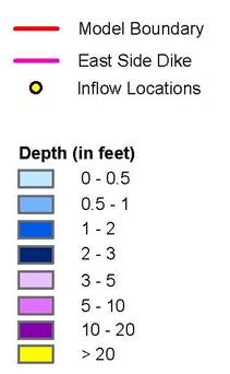
15 Potential Flooding (Breach Scenario)
16 Erosion and Scour Potential Scour Calculation, using CVWD Standard Procedures (Blench Regime) MIKE Model Results Used Peak Unit Discharge Threshold Velocities Effective Flow Width (Lacey Equation) Scour Protection Needed for 12,300 feet of Dike (~2.3 miles); Upstream Reach Only

17 Erosion Protection Reaches
18 Geotechnical Investigation Completed by GENTERRA Used H&H and Erosion and Scour Report Findings Seepage and Slope Stability met Minimum Factors of Safety O&M Plan for Seismic Activity Required Recommended Soil Cement Blanket Liner for Areas of Potential Erosion Estimated Cost of Soil Cement $6 Million to $7.5 Million
19 Overall Summary Updated Hydrology and Hydraulics Adequate Freeboard for Reach Stability and Seepage Minimum Factors of Safety Slope Protection Necessary for 2.3 miles of Dike Recommendation of 8-foot wide soil cement blanket liner where Erosion and Scour Analysis Showed Potential Erosion
20 FEMA Review FEMA Provided General Overall Review of CVWD Documents Hydrology and Hydraulics Report Geotechnical Analysis Erosion and Scour Analysis If recommendations are implemented the dike should meet the requirements of 44 CFR Section of the NFIP Regulations
21 Certification Steps Completed H&H Report Freeboard Estimation Sediment Transport Erosion and Scour Study Embankment Protection Geotechnical Investigation Stability Seepage Potential Settling of Levee
22 Next Steps for Certification Feedback from LLPT Meeting #2 Technical Review from FEMA Detailed Design of Erosion Protection Measures, Plans and Specifications Complete Remaining 44 CFR Requirements Topographic Workmap, Engineering Drawings, O&M Plan and Closure/Interior Drainage Reports LLPT Meeting #3 Application for CLOMR
23 Timeline Re-mapping of Flood Hazards (2 to 3 years) LAMP Procedure Physical Map Revision (PMR) Certification of Levee (3 to 4 years) Design of Erosion Protection and Environmental Studies (ESA) CLOMR Prepare Bid Document and Select Contractor Construction followed by LOMR Moving Towards Certification Only

24 Questions?
INFLOW DESIGN FLOOD CONTROL SYSTEM PLAN 40 C.F.R. PART PLANT YATES ASH POND 2 (AP-2) GEORGIA POWER COMPANY
 GEORGIA POWER COMPANY") INFLOW DESIGN FLOOD CONTROL SYSTEM PLAN 40 C.F.R. PART 257.82 PLANT YATES ASH POND 2 (AP-2) GEORGIA POWER COMPANY EPA s Disposal of Coal Combustion Residuals from Electric Utilities Final Rule (40 C.F.R.
INFLOW DESIGN FLOOD CONTROL SYSTEM PLAN 40 C.F.R. PART 257.82 PLANT YATES ASH POND 2 (AP-2) GEORGIA POWER COMPANY EPA s Disposal of Coal Combustion Residuals from Electric Utilities Final Rule (40 C.F.R.
LEVEE DESIGN FOR FLOOD PROTECTION ON ALLUVIAL FANS
 LEVEE DESIGN FOR FLOOD PROTECTION ON ALLUVIAL FANS BRUCE M. PHILLIPS 1 ABSTRACT The dynamic nature of alluvial fans in arid environments offers numerous floodplain management challenges primarily due to
LOMR SUBMITTAL LOWER NEHALEM RIVER TILLAMOOK COUNTY, OREGON
 LOMR SUBMITTAL LOWER NEHALEM RIVER TILLAMOOK COUNTY, OREGON Prepared for: TILLAMOOK COUNTY DEPARTMENT OF COMMUNITY DEVELOPMENT 1510-B THIRD STREET TILLAMOOK, OR 97141 Prepared by: 10300 SW GREENBURG ROAD,
LOMR SUBMITTAL LOWER NESTUCCA RIVER TILLAMOOK COUNTY, OREGON
 LOMR SUBMITTAL LOWER NESTUCCA RIVER TILLAMOOK COUNTY, OREGON Prepared for: TILLAMOOK COUNTY DEPARTMENT OF COMMUNITY DEVELOPMENT 1510-B THIRD STREET TILLAMOOK, OR 97141 Prepared by: 10300 SW GREENBURG ROAD,
UNSECURED ORIGINAL CHG HOMEOWNERS EXEMPTION
 UN UN HOX 01-1001 Y GENERAL 220,385,876.30 9,752,074.53 2,535,737.41 0.00 0.00 0.00 01-1121 Y CO FREE LIBRARY 14,093,156.50 623,622.14 162,154.42 0.00 0.00 0.00 01-1123 Y CO STRUCTURE FIRE PROTECTION 40,244,078.83
Borrego Springs Alluvial Fan Active and Inactive Area Mapping, County of San Diego, California. Julianne J. Miller Steve N. Bacon Richard H.
 Borrego Springs Alluvial Fan Active and Inactive Area Mapping, County of San Diego, California Julianne J. Miller Steve N. Bacon Richard H. French Outline Where is Borrego Springs, California? History
Groundwater Replenishment In The Coachella Valley, CA. WESTCAS 2018 Annual Conference June 21, 2018 Zoe Rodriguez del Rey, Water Resources
 Groundwater Replenishment In The Coachella Valley, CA WESTCAS 2018 Annual Conference June 21, 2018 Zoe Rodriguez del Rey, Water Resources Coachella Valley Indio Mecca Palm Springs La Quinta Thermal 2 Coachella
STRUCTURAL STABILITY ASSESSMENT
 STRUCTURAL STABILITY ASSESSMENT CFR 257.73(d) Bottom Ash Pond Complex Cardinal Plant Brilliant, Ohio October, 2016 Prepared for: Cardinal Operating Company Cardinal Plant Brilliant, Ohio Prepared by: Geotechnical
Presentation Program Outline
 Presentation Program Outline Overview Countermeasures / Planning Process Levees / Dikes / Diversions Channelization / Conveyance Grade Control Structures Detention Basin / Debris Basin Case Study Localized
Appendix E Guidance for Shallow Flooding Analyses and Mapping
 Appendix E Guidance for Shallow Flooding Analyses and Mapping E.1 Introduction Different types of shallow flooding commonly occur throughout the United States. Types of flows that result in shallow flooding
UPPER COSUMNES RIVER FLOOD MAPPING
 UPPER COSUMNES RIVER FLOOD MAPPING DRAFT BASIC DATA NARRATIVE FLOOD INSURANCE STUDY SACRAMENTO COUTY, CALIFORNIA Community No. 060262 November 2008 Prepared By: CIVIL ENGINEERING SOLUTIONS, INC. 1325 Howe
PENNSYLVANIA DEPARTMENT OF TRANSPORTATION ENGINEERING DISTRICT 3-0
 PENNSYLVANIA DEPARTMENT OF TRANSPORTATION ENGINEERING DISTRICT 3-0 LYCOMING COUNTY S.R.15, SECTION C41 FINAL HYDROLOGIC AND HYDRAULIC REPORT STEAM VALLEY RUN STREAM RELOCATION DATE: June, 2006 REVISED:
ENGINEER S CERTIFICATION OF FAULT AREA DEMONSTRATION (40 CFR )
") PLATTE RIVER POWER AUTHORITY RAWHIDE ENERGY STATION BOTTOM ASH TRANSFER (BAT) IMPOUNDMENTS LARIMER COUNTY, CO ENGINEER S CERTIFICATION OF FAULT AREA DEMONSTRATION (40 CFR 257.62) FOR COAL COMBUSTION RESIDUALS
PLATTE RIVER POWER AUTHORITY RAWHIDE ENERGY STATION BOTTOM ASH TRANSFER (BAT) IMPOUNDMENTS LARIMER COUNTY, CO ENGINEER S CERTIFICATION OF FAULT AREA DEMONSTRATION (40 CFR 257.62) FOR COAL COMBUSTION RESIDUALS
Section 4: Model Development and Application
 Section 4: Model Development and Application The hydrologic model for the Wissahickon Act 167 study was built using GIS layers of land use, hydrologic soil groups, terrain and orthophotography. Within
Big Rivers Electric Corporation Disposal of Coal Combustion Residuals (CCR) from Electric Utilities Final Rule CCR Impoundment Liner Assessment Report
 from Electric Utilities Final Rule CCR Impoundment Liner Assessment Report") Big Rivers Electric Corporation Disposal of Coal Combustion Residuals (CCR) from Electric Utilities Final Rule CCR Impoundment Liner Assessment Report CCR Surface Impoundment Information Name: Operator:
Big Rivers Electric Corporation Disposal of Coal Combustion Residuals (CCR) from Electric Utilities Final Rule CCR Impoundment Liner Assessment Report CCR Surface Impoundment Information Name: Operator:
Dealing with Zone A Flood Zones. Topics of Discussion. What is a Zone A Floodplain?
 Dealing with Zone A Flood Zones Topics of Discussion Overview of Zone A Floodplains Permitting Development in Zone A Floodplains Estimating Flood Elevations in Zone A Flood Insurance Implications Letters
Final Results and Outreach Lessons Learned
 FEMA REGION III COASTAL HAZARD STUDY Final Results and Outreach Lessons Learned June 4, 2014 Mari Radford Christine Worley Robin Danforth David Bollinger FEMA Region III RAMPP FEMA Region III FEMA Region
ENGINEER'S REPORT ON WATER SUPPLY AND REPLENISHMENT ASSESSMENT East Whitewater River Subbasin Area of Benefit
 ENGINEER'S REPORT ON WATER SUPPLY AND REPLENISHMENT ASSESSMENT 2014-2015 Prepared for COACHELLA VALLEY WATER DISTRICT April 2014 Public Meeting April 8, 2014 File: 0643.533 COACHELLA VALLEY WATER DISTRICT
VOLUME 3 OF 3 FAIRFIELD COUNTY, OHIO AND INCORPORATED AREAS COMMUNITY NAME NUMBER COMMUNITY NAME NUMBER
 VOLUME 3 OF 3 FAIRFIELD COUNTY, OHIO AND INCORPORATED AREAS COMMUNITY NAME NUMBER COMMUNITY NAME NUMBER AMANDA, VILLAGE OF * 390688 PICKERINGTON, CITY OF 390162 BALTIMORE, VILLAGE OF 390159 PLEASANTVILLE,
Appendix C Correlated PM10 Concentrations and Winds
 Correlated PM10 Concentrations and Winds The following graphs illustrate the direct correlation between wind speeds 1 and PM 10 concentrations at select monitoring sites within the Salton Sea Air Basin
Background and Purpose of Meeting. River Towers Meeting. Flood Risk Management Study Alternatives Overview
 1 and Purpose of Meeting River Towers Meeting Flood Risk Management Study Alternatives Overview September 23, 2014 There is no "proposed" flood risk management solution for this area at this time Fairfax
LOCATED IN INDIAN RIVER COUNTY PREPARED FOR S.J.R.W.M.D. AND F.W.C.D. DECEMBER, 2003 Updated 2007 Updated May 2014 PREPARED BY
 FELLSMERE WATER CONTROL DISTRICT EAST MASTER DRAINAGE PLAN AND STORMWATER HYDROLOGIC ANALYSIS OF THE GRAVITY DRAINAGE SYSTEM LOCATED BETWEEN THE EAST BOUNDARY, LATERAL U, THE MAIN CANAL, AND DITCH 24 LOCATED
HISTORY OF CONSTRUCTION FOR EXISTING CCR SURFACE IMPOUNDMENT PLANT GASTON ASH POND 40 CFR (c)(1)(i) (xii)
(1)(i) (xii)") HISTORY OF CONSTRUCTION FOR EXISTING CCR SURFACE IMPOUNDMENT PLANT GASTON ASH POND 40 CFR 257.73(c)(1)(i) (xii) (i) Site Name and Ownership Information: Site Name: E.C. Gaston Steam Plant Site Location:
HISTORY OF CONSTRUCTION FOR EXISTING CCR SURFACE IMPOUNDMENT PLANT GASTON ASH POND 40 CFR 257.73(c)(1)(i) (xii) (i) Site Name and Ownership Information: Site Name: E.C. Gaston Steam Plant Site Location:
FEMA REGION III COASTAL HAZARD STUDY
 FEMA REGION III COASTAL HAZARD STUDY Impacts and Rollout June 11, 2013 Robin Danforth, FEMA Region III David Bollinger, FEMA Region III Jeff Gangai, RAMPP Christine Worley, RAMPP 1 Today s Discussion Overview
YELLOWSTONE RIVER FLOOD STUDY REPORT TEXT
 YELLOWSTONE RIVER FLOOD STUDY REPORT TEXT TECHNICAL REPORT Prepared for: City of Livingston 411 East Callender Livingston, MT 59047 Prepared by: Clear Creek Hydrology, Inc. 1627 West Main Street, #294
4.9 GEOLOGY AND SOILS
 4.9 GEOLOGY AND SOILS 4.9.1 EXISTING CONDITIONS TOPOGRAPHY AND RELIEF Zone 40 is located in the central portion of Sacramento County. The topography of the county is represented by three physiographic
The last three sections of the main body of this report consist of:
 Threatened and Endangered Species Geological Hazards Floodplains Cultural Resources Hazardous Materials A Cost Analysis section that provides comparative conceptual-level costs follows the Environmental
HYDROLOGIC AND HYDRAULIC REPORT FOR SR. 0522, SECTION 5BN ALONG BLACKLOG CREEK CROMWELL TOWNSHIP HUNTINGDON COUNTY. Prepared for:
 HYDROLOGIC AND HYDRAULIC REPORT FOR SR. 0522, SECTION 5BN ALONG BLACKLOG CREEK CROMWELL TOWNSHIP Prepared for: KCI Technologies, Inc. Mechanicsburg, PA and Pennsylvania Department of Transportation Engineering
Historical channel change on the Upper Gila River, Arizona and New Mexico in response to anthropogenic modifications and extreme floods
 Historical channel change on the Upper Gila River, Arizona and New Mexico in response to anthropogenic modifications and extreme floods www.archives.gov www.paztcn.wr.usgs.gov wrh.noaa.gov Upper Gila River
Issue 44: Phase II & III H&H Issues Date: 07/03/2006 Page 1
 Background Phase I of the NCFMP studies have primarily focused on the coastal plain and sandhills physiographic regions in of the State. Phase II and III study areas will focus on the piedmont, foothills,
Pequabuck River Flooding Study and Flood Mitigation Plan The City of Bristol and Towns of Plainville and Plymouth, CT
 Pequabuck River Flooding Study and Flood Mitigation Plan The City of Bristol and Towns of Plainville and Plymouth, CT Raymond Rogozinski and Maged Aboelata The City of Bristol and Towns of Plainville and
NEEDLES S STREET LEVEE SYSTEM SAN BERNARDINO COUNTY, CALIFORNIA NLD SYSTEM ID #
 SAN BERNARDINO COUNTY, CALIFORNIA NLD SYSTEM ID # 3805030008 PERIODIC INSPECTION REPORT NO. 1 GENERALIZED EXECUTIVE SUMMARY FINAL SYSTEM RATING: MINIMALLY ACCEPTABLE FINAL RATING DATE: AUGUST 2014 PERIODIC
MORGAN COUNTY COLORADO, AND INCORPORATED AREAS
 MORGAN COUNTY COLORADO, AND INCORPORATED AREAS VOLUME 1 OF 1 Morgan County COMMUNITY NAME COMMUNNITY NUMBER BRUSH, CITY OF 080130 FORT MORGAN, CITY OF 080131 LOG LANE VILLAGE, TOWN OF* 080217 MORGAN COUNTY
Association of State Floodplain Managers, Inc.
 Association of State Floodplain Managers, Inc. 2809 Fish Hatchery Road, Suite 204, Madison, WI 53713 Phone: 608-274-0123 Fax: 608-274-0696 Email: asfpm@floods.org Website: www.floods.org Need for Updating
CHAPTER GEOLOGICALLY HAZARDOUS AREAS Applicability Regulations.
 CHAPTER 19.07 GEOLOGICALLY HAZARDOUS AREAS 19.07.010 Applicability. Geologically hazardous areas may pose a threat to the health and safety of citizens when incompatible development is sited in areas of
Chapter 7 Mudflow Analysis
 Chapter 7 Mudflow Analysis 7.0 Introduction This chapter provides information on the potential and magnitude of mud floods and mudflows that may develop in Aspen due to rainfall events, snowmelt, or rain
Base Level Engineering FEMA Region 6
 Base Level Engineering Over the past five years, has been evaluating its investment approach and data preparation work flow to establish an efficient and effective change in operation, generating an approach
Smart Flood Risk Management Solutions
 Smart Flood Risk Management Solutions - RHDHV s Experience in the Gulf of Mexico Mathijs van Ledden, Marten Hillen and Ries Kluskens Challenge Extreme weather around the world (hurricanes, cyclones, extratropical
 Red River Flooding June 2015 Caddo and Bossier Parishes Presented by: Flood Technical Committee Where the Rain Falls Matters I-30 versus I-20 I-20 Backwater and Tributary Floods (Localized) 2016 Flood
CASE STUDY #9 - Brushy Fork Dam, Sugar Grove, West Virginia
 CASE STUDY #9 - Brushy Fork Dam, Sugar Grove, West Virginia Brushy Fork Dam is a flood control structure built by the Soil Conservation Service southeast of the city of Franklin in Pendleton County, West
Miami-Dade County Technical Update Meeting South Florida Coastal Study. May 11, 2016
 Miami-Dade County Technical Update Meeting South Florida Coastal Study May 11, 2016 Welcome and Introductions FEMA Region IV Christina Lindemer Technical Lead Production and Technical Services (PTS) Contractor
Swift Creek Sediment Management Action Plan (SCSMAP)
") Swift Creek Sediment Management Action Plan (SCSMAP) PHASE 2 PROJECT PLAN PROPOSAL Whatcom County Public Works Department 322 N. Commercial Street, Suite 210 Bellingham, WA 98225 (360) 676-6692 June 2013
Swift Creek Sediment Management Action Plan (SCSMAP) PHASE 2 PROJECT PLAN PROPOSAL Whatcom County Public Works Department 322 N. Commercial Street, Suite 210 Bellingham, WA 98225 (360) 676-6692 June 2013
State Water Survey Division SURFACE WATER SECTION
 State Water Survey Division SURFACE WATER SECTION AT THE UNIVERSITY OF ILLINOIS Illinois Department of Energy and Natural Resources SWS Miscellaneous Publication 88 SEDIMENTATION OF POOL 19 ON THE MISSISSIPPI
YUMA COUNTY, ARIZONA AND INCORPORATED AREAS
 YUMA COUNTY, ARIZONA AND INCORPORATED AREAS Community Name Community Number SAN LUIS, CITY OF 040136 SOMERTON, CITY OF 1 040114 WELLTON, TOWN OF 040112 YUMA, CITY OF 040102 YUMA COUNTY (UNINCORPORATED
Delaware Bay Dikes Repair and Prevention Project Preliminary Design for New Castle Dikes
 City of New Castle Presentation Delaware Bay Dikes Repair and Prevention Project Preliminary Design for New Castle Dikes New Castle Conservation District DNREC August 22, 2012 Agenda Project Background
WEST CATARACT CREEK DAM FINAL DESIGN REPORT
 DAMsel In Distress Engineering 2112 S Huffer Ln Flagstaff, AZ 86011 (520) 981-9515 WEST CATARACT CREEK DAM FINAL DESIGN REPORT Prepared for: Dr. Charles Schlinger Mr. Mark Lamer TABLE OF CONTENTS Contents
COACHELLA VALLEY WATER DISTRICT HOVLEY LANE EAST PALM DESERT, CA (760) COACHELLA VALLEY WATER DISTRICT
 COACHELLA VALLEY WATER DISTRICT") File: 0643.533 COACHELLA VALLEY WATER DISTRICT 75-515 HOVLEY LANE EAST PALM DESERT, CA 92211 (760) 398-2661 COACHELLA VALLEY WATER DISTRICT ENGINEER'S REPORT ON WATER SUPPLY AND REPLENISHMENT ASSESSMENT
File: 0643.533 COACHELLA VALLEY WATER DISTRICT 75-515 HOVLEY LANE EAST PALM DESERT, CA 92211 (760) 398-2661 COACHELLA VALLEY WATER DISTRICT ENGINEER'S REPORT ON WATER SUPPLY AND REPLENISHMENT ASSESSMENT
Ed Curtis, PE, CFM, FEMA Region IX and Darryl Hatheway, CFM, AECOM ASFPM 2016, Grand Rapids, MI
 Methodology to Determine Process-Based Total Water Level Profiles in Areas Dominated by Wave Runup Ed Curtis, PE, CFM, FEMA Region IX and Darryl Hatheway, CFM, AECOM ASFPM 2016, Grand Rapids, MI Thurs.
MEMORANDUM. Situation. David Ford Consulting Engineers, Inc J Street, Suite 200 Sacramento, CA Ph Fx
 David Ford Consulting Engineers, Inc. 2015 J Street, Suite 200 Sacramento, CA 95811 Ph. 916.447.8779 Fx. 916.447.8780 MEMORANDUM To: Brad Moore, PE, USACE From: Nathan Pingel, PE (Lic # CA 63242), and
CR AAO Bridge. Dead River Flood & Natural Channel Design. Mitch Koetje Water Resources Division UP District
 CR AAO Bridge Dead River Flood & Natural Channel Design Mitch Koetje Water Resources Division UP District Old County Road AAO Bridge Map courtesy of Marquette County Silver Lake Basin McClure Basin
Development of a Fluvial Erosion Hazard Mitigation Program for Indiana
 Development of a Fluvial Erosion Hazard Mitigation Program for Indiana Indiana Watersheds Webinar Series October 12,2011 Robert Barr Center for Earth and Environmental Science Department of Earth Sciences
CCR Rule Annual Inspection Report (cont.) 2
 2") The inspection findings consisted of maintenance items and items that were not observed to be signs or potential signs of significant structural weakness. No deficiencies or disrupting conditions that
The inspection findings consisted of maintenance items and items that were not observed to be signs or potential signs of significant structural weakness. No deficiencies or disrupting conditions that
Chapter 7 Mudflow Analysis
 Chapter 7 Mudflow Analysis 7.0 Introduction This chapter provides information on the potential and magnitude of mud floods and mudflows that may develop in Aspen due to rainfall events, snowmelt, or rain
THE NEED FOR AN ADDITIONAL SPILLWAY AT THE SANFORD DAM BOILING SPRING LAKES, NC. Presentation for The Brunswick County Commissioners April 20, 2015
 THE NEED FOR AN ADDITIONAL SPILLWAY AT THE SANFORD DAM BOILING SPRING LAKES, NC Presentation for The Brunswick County Commissioners April 20, 2015 The Sanford Dam Earth Dam constructed in 1961 Drainage
New Mapping, Recent Events What do we know? June 9, 2011
 New Mapping, Recent Events What do we know? June 9, 2011 e FEMA Mapping Process Current Flood Insurance Rate Maps (FIRMs) or Floodplain Maps date back to the early 1970 s. The District contracted with
Case Study 2: Twenty-mile Creek Rock Fords
 Case Study : Twenty-mile Creek Rock Fords Location Crossing Description Washington. Okanagan National Forest. Methow Valley Ranger District. Chewuch river basin, East Chewuch Road. The Twenty-mile Creek
Technical Memorandum No
 Pajaro River Watershed Study in association with Technical Memorandum No. 1.2.10 Task: Evaluation of Four Watershed Conditions - Sediment To: PRWFPA Staff Working Group Prepared by: Gregory Morris and
Emergency Action Plan (EAP) Tata Pond Dam
 Tata Pond Dam") For Official Use Only Not for Public Distribution 02/03/16 Emergency Action Plan (EAP) Tata Pond Dam State of Connecticut Dam ID: 0000 Town or City, County, Connecticut Name of Dam Owner Dam Hazard Classification
For Official Use Only Not for Public Distribution 02/03/16 Emergency Action Plan (EAP) Tata Pond Dam State of Connecticut Dam ID: 0000 Town or City, County, Connecticut Name of Dam Owner Dam Hazard Classification
Storm Surge Analysis Update Meeting Cross City, Florida June 17, 2014
 Big Bend Coastal Storm Surge Study Storm Surge Analysis Update Meeting Cross City, Florida June 17, 2014 Introductions Risk MAP Project Team FEMA Region IV Florida Division of Emergency Management (FDEM)
County of Riverside Property Tax Costs Allocation FY 2017/2018 with FY 2016/2017 Costs Updated: 12/18/2017
 01-1001 COUNTY GENERAL FUND 8,725,331 134,431 4,356,970 220,385,876 9,752,075 2,535,737 245,890,419 245,890,419 0.09144709 2,418,818 0 2,418,818 0 0 0.00 01-1121 COUNTY FREE LIBRARY 467,528 4,850 91,902
APPENDIX B HYDROLOGY
 APPENDIX B HYDROLOGY TABLE OF CONTENTS 1.0 INTRODUCTION... 1 2.0 PROBABLE MAXIMUM PRECIPITATION (PMP)... 1 3.0 DESIGN FLOW CALCULATION... 1 4.0 DIVERSION CHANNEL SIZING... 2 5.0 REFERENCES... 4 LIST OF
GEOL 1121 Earth Processes and Environments
 GEOL 1121 Earth Processes and Environments Wondwosen Seyoum Department of Geology University of Georgia e-mail: seyoum@uga.edu G/G Bldg., Rm. No. 122 Seyoum, 2015 Chapter 6 Streams and Flooding Seyoum,
SAVANNAH HARBOR EXPANSION BANK EROSION STUDY UPDATE
 CESAS-EN-GS SAVANNAH HARBOR EXPANSION BANK EROSION STUDY UPDATE GEOTECHNICAL AND HTRW BRANCH SOILS SECTION CITY FRONT, BIGHT SECTION, FORT PULASKI & NORTH TYBEE ISLAND GEORGIA 23 June 2011 CESAW-TS-EG
J.H. Campbell Generating Facility Pond A - Location Restriction Certification Report
 J.H. Campbell Generating Facility Pond A - Location Restriction Certification Report Pursuant to: 40 CFR 257.60 40 CFR 257.61 40 CFR 257.62 40 CFR 257.63 40 CFR 257.64 Submitted to: Consumers Energy Company
Background on the March 13-14, 2007 Flooding in Browns Valley (Traverse County), Minnesota
, Minnesota") Background on the March 13-14, 2007 Flooding in Browns Valley (Traverse County), Minnesota Report to the Minnesota Governor s Office Prepared by: Minnesota Department of Natural Resources Waters Division
Background on the March 13-14, 2007 Flooding in Browns Valley (Traverse County), Minnesota Report to the Minnesota Governor s Office Prepared by: Minnesota Department of Natural Resources Waters Division
Mount St. Helens Project Cowlitz River Levee Systems 2009 Level of Flood Protection Update Summary
 Mount St. Helens Project Cowlitz River Levee Systems 2009 Level of Flood Protection Update Summary Cowlitz River at Longview/Kelso, Washington February 4, 2010 Executive Summary USACE periodically updates
Stone Outlet Sediment Trap
 3.12 Sediment Control Description: A stone outlet sediment trap is a small detention area formed by placing a stone embankment with an integral stone filter outlet across a drainage swale for the purpose
Mapping of Future Coastal Hazards. for Southern California. January 7th, David Revell, Ph.D. E.
 Mapping of Future Coastal Hazards for Southern California January 7th, 2014 David Revell, Ph.D. drevell@esassoc.com E. Vandebroek, 2012 Outline Coastal erosion hazard zones Flood hazard zones: Coastal
May 7, Roger Leventhal, P.E. Marin County Public Works Laurel Collins Watershed Sciences
 May 7, 2013 Roger Leventhal, P.E. Marin County Public Works Laurel Collins Watershed Sciences Background Funded in 2009 under EPA 2100 Grant for $30k and managed by SFEP Project Goals: Update original
Technical Memorandum No Sediment Model
 Pajaro River Watershed Study in association with Technical Memorandum No. 1.2.9 Sediment Model Task: Development of Sediment Model To: PRWFPA Staff Working Group Prepared by: Gregory Morris and Elsie Parrilla
Randall W. Parkinson, Ph.D., P.G. Institute of Water and Environment Florida International University
 An Update on Adaptation Action Activities Undertaken Since Completion of the City of Satellite Beach (FL) Vulnerability Assessment to Rising Seas (2010) Randall W. Parkinson, Ph.D., P.G. Institute of Water
Final Recirculated Environmental Impact Report/ Supplemental Final Environmental Impact Statement September 2007 Technical Appendices APPENDIX E
 Final Recirculated Environmental Impact Report/ Supplemental Final Environmental Impact Statement September 27 Technical Appendices APPENDIX E Water Resources Background Report Prepared by Terra Nova Planning
Vegetation effects on river hydraulics. Johannes J. (Joe) DeVries David Ford Consulting Engineers, Inc. Sacramento, CA
 DeVries David Ford Consulting Engineers, Inc. Sacramento, CA") Vegetation effects on river hydraulics Johannes J. (Joe) DeVries David Ford Consulting Engineers, Inc. Sacramento, CA jjdevries@ford-consulting.com SAC05 D2P31 RM 99.0L VIEW UPSTREAM AT UPSTREAM END DWR
Vegetation effects on river hydraulics Johannes J. (Joe) DeVries David Ford Consulting Engineers, Inc. Sacramento, CA jjdevries@ford-consulting.com SAC05 D2P31 RM 99.0L VIEW UPSTREAM AT UPSTREAM END DWR
Chapter 5 CALIBRATION AND VERIFICATION
 Chapter 5 CALIBRATION AND VERIFICATION This chapter contains the calibration procedure and data used for the LSC existing conditions model. The goal of the calibration effort was to develop a hydraulic
Dan Miller + Kelly Burnett, Kelly Christiansen, Sharon Clarke, Lee Benda. GOAL Predict Channel Characteristics in Space and Time
 Broad-Scale Models Dan Miller + Kelly Burnett, Kelly Christiansen, Sharon Clarke, Lee Benda GOAL Predict Channel Characteristics in Space and Time Assess Potential for Fish Use and Productivity Assess
Todd N. Loar, PG, CEG
 1 USACE DAM RISK ASSESSMENT PROGRAM OVERVIEW AND HOW ENGINEERING GEOLOGY CONTRIBUTES TO THE LEVEL OF CONFIDENCE AND RESULTS 255 255 255 237 237 237 217 217 217 200 200 200 0 0 0 163 163 163 131 132 122
Discovery Data Questionnaire
 Region III Discovery Data Questionnaire Thank you for taking the time to complete this Discovery Data questionnaire. It will provide important information to help FEMA better understand flood risk issues
3.11 Floodplains Existing Conditions
 Other stormwater control practices may be needed to mitigate water quality impacts. In addition to detention facilities, other practices such as vegetated basins/buffers, infiltration basins, and bioswales
Standards for Soil Erosion and Sediment Control in New Jersey May 2012
 STANDARD FOR SEDIMENT BASIN Definition A barrier, dam, excavated pit, or dugout constructed across a waterway or at other suitable locations to intercept and retain sediment. Basins created by construction
Technical Review of Pak Beng Hydropower Project (1) Hydrology & Hydraulics and (2) Sediment Transport & River Morphology
 Hydrology & Hydraulics and (2) Sediment Transport & River Morphology") Technical Review of Pak Beng Hydropower Project (1) Hydrology & Hydraulics and (2) Sediment Transport & River Morphology The 2 nd Regional Stakeholder Forum The Pak Beng Hydropower Project 5 th May 2017
Technical Review of Pak Beng Hydropower Project (1) Hydrology & Hydraulics and (2) Sediment Transport & River Morphology The 2 nd Regional Stakeholder Forum The Pak Beng Hydropower Project 5 th May 2017
HURRICANE SANDY LIMITED REEVALUATION REPORT UNION BEACH, NEW JERSEY DRAFT ENGINEERING APPENDIX SUB APPENDIX A PRELIMINARY FLOODWALL DESIGN
 HURRICANE SANDY LIMITED REEVALUATION REPORT UNION BEACH, NEW JERSEY DRAFT ENGINEERING APPENDIX SUB APPENDIX A PRELIMINARY FLOODWALL DESIGN March 2014Revised March 2015 UNITED STATES ARMY CORPS OF ENGINEERS
North Carolina Simplified Inundation Maps For Emergency Action Plans December 2010; revised September 2014; revised April 2015
 North Carolina Simplified Inundation Maps For Emergency Action Plans December 2010; revised September 2014; revised April 2015 INTRODUCTION Emergency Action Plans (EAPs) are critical to reducing the risks
1 INTRODUCTION AND MAJOR FINDINGS... 1
 Memorandum To: Lindsey Clark, Stillwater Valley Watershed Council Coordinator From: Chad Raisland, Pioneer Technical Services, Inc. and Karin Boyd, Applied Geomorphology, Inc. CC: Tanya Lester, Stillwater
Sacramento River Bank Protection Project
 2005 - FIELD RECONNAISSANCE REPORT OF BANK EROSION SITES - SACRAMENTO RIVER FLOOD CONTROL LEVEES AND TRIBUTARIES Sacramento River Bank Protection Project Project No. 32-0530.10, Task 3 Prepared for: U.S.
4.7 GEOLOGY AND SOILS
 4.7 GEOLOGY AND SOILS 4.7.1 INTRODUCTION This section describes geology, soils, and seismicity conditions in the vicinity of the project sites and assesses the potential for the project to be affected
Tom Ballestero University of New Hampshire. 1 May 2013
 Tom Ballestero University of New Hampshire 1 May 2013 1 Hydrology 2 Basic Hydrology Low flows most common Flows that fill the stream to the banks and higher are much less common Filling the stream to the
Document Title. Estimating the Value of Partner Contributions to Flood Mapping Projects. Blue Book
 Document Title Estimating the Value of Partner Contributions to Flood Mapping Projects Blue Book Version 1.1 November 2006 Table of Contents 1. Background...1 2. Purpose...1 3. Overview of Approach...2
Rock Sizing for Small Dam Spillways
 Rock Sizing for Small Dam Spillways STORMWATER MANAGEMENT PRACTICES Photo 1 Rock-lined spillway on a construction site sediment basin Photo 2 Rock-lined spillway on a small farm dam 1. Introduction A chute
Geologic Hazards and Whatcom County Code. Andy Wiser, L.E.G , ext 50274
 Geologic Hazards and Whatcom County Code Andy Wiser, L.E.G. awiser@whatcomcounty.us 360.676.6907, ext 50274 Chapter 16.16, Article 3 Geologically Hazardous Areas 16.16.300 Purpose: 1. Minimize Risk: Minimize
Coastal Flood Risk Study Project for East Coast Central Florida Study Area
 Coastal Flood Risk Study Project for East Coast Central Florida Study Area St Lucie County, Florida Flood Risk Review Meeting March 28, 2017 Introductions Risk MAP Project Team FEMA Region IV BakerAECOM,
APPENDIX A M&T/Llano Seco Long-Term Water Reliability Study These photos are examples of rock spurs in use throughout the United States
 APPENDIX A M&T/Llano Seco Long-Term Water Reliability Study These photos are examples of rock spurs in use throughout the United States Glenn Colusa Irrigation District completed a Sacramento River project
Location Restrictions Certification Report NIPSCO Michigan City Generating Station Boiler Slag Pond
 Location Restrictions Certification Report NIPSCO Michigan City Generating Station Boiler Slag Pond Pursuant to: 40 CFR 257.60 40 CFR 257.61 40 CFR 257.62 40 CFR 257.63 40 CFR 257.64 Submitted to: Northern
IV. ENVIRONMENTAL IMPACT ANALYSIS E. GEOLOGY AND SOILS
 IV. ENVIRONMENTAL IMPACT ANALYSIS E. GEOLOGY AND SOILS INTRODUCTION This section evaluates potential impacts related to geology, including seismicity, and soils associated with development of the proposed
Flash flood disaster in Bayangol district, Ulaanbaatar
 Flash flood disaster in Bayangol district, Ulaanbaatar Advanced Training Workshop on Reservoir Sedimentation Management 10-16 October 2007. IRTCES, Beijing China Janchivdorj.L, Institute of Geoecology,MAS
Chapter 3 Erosion in the Las Vegas Wash
 Chapter 3 Erosion in the Las Vegas Wash Introduction As described in Chapter 1, the Las Vegas Wash (Wash) has experienced considerable change as a result of development of the Las Vegas Valley (Valley).
Out with the Old, In with the New: Implementing the Results of the Iowa Rapid Floodplain Modeling Project
 Out with the Old, In with the New: Implementing the Results of the Iowa Rapid Floodplain Modeling Project Traci Tylski, E.I., CFM Hydraulics Engineer USACE - Omaha District Traci.M.Tylski@USACE.army.mil
High Resolution Numerical Weather Prediction for High Impact and Extreme Weather Events in 2014 across Southern California
 High Resolution Numerical Weather Prediction for High Impact and Extreme Weather Events in 2014 across Southern California Alex Tardy Alexander.Tardy@noaa.gov NWS San Diego Warning Coordination Meteorologist
This is a digital document from the collections of the Wyoming Water Resources Data System (WRDS) Library.
 Library.") This is a digital document from the collections of the Wyoming Water Resources Data System (WRDS) Library. For additional information about this document and the document conversion process, please contact
This is a digital document from the collections of the Wyoming Water Resources Data System (WRDS) Library. For additional information about this document and the document conversion process, please contact
Modeling Great Britain s Flood Defenses. Flood Defense in Great Britain. By Dr. Yizhong Qu
 Modeling Great Britain s Flood Defenses AIRCurrents Editor s note: AIR launched its Inland Flood Model for Great Britain in December 2008. The hazard module captures the physical processes of rainfall-runoff
Appendix C Fluvial Flood Hazards
 Appendix C Fluvial Flood Hazards Sea Level Rise Vulnerability Assessment and Adaptation Project March 2019 Contents Contents... i Figures... i Tables... i Definitions, Acronyms, & Abbreviations... ii