DISTRIBUTION of WATER RESOURCES
|
|
|
- Kevin Pearson
- 5 years ago
- Views:
Transcription
1 DAM GEOLOGY

2 DISTRIBUTION of WATER RESOURCES
3
4 Definition A dam is a structure which prevents the flow of water and accumulates it in a reservoir Karakaya Dam/Diyarbakır Atatürk Dam/Şanlıurfa
5 Needs for Dam Construction 1. Drinking and domestic water supply 2. Flood control 3. Irrigation 4. Industrial water supply 5. Hydroelectric energy production 6. Retention and control of sediments and Inland navigation, Improvement of water quality, Fish Farming, Recreation facilities

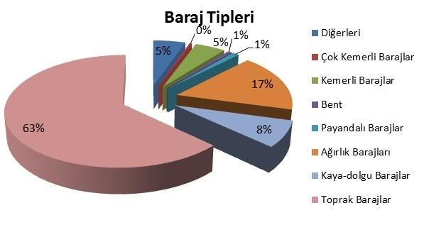
6 BREAKDOWN by PURPOSE of DAMS in EUROPE
7
8
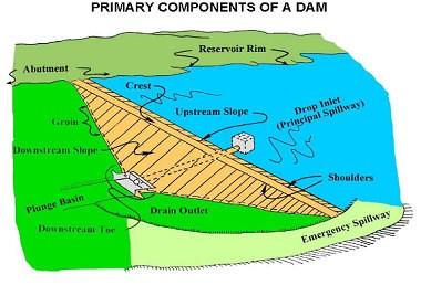
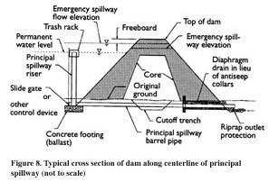
9 COMPONENTS of DAMS
10 Dam types
11 ACCORDING to the SIZE of the DAM 1. Large (Big) dam 2. Small dam International Commision on Large Dams, (ICOLD) assumes a dam as big when its height is bigger than 15m. If the height of the dam is between 10m and 15m and matches the following criteria, then ICOLD accepts the dam as big: If the crest length is bigger than 500m If the reservoir capacity is larger than 1 million m 3 If the flood discharge is more than 2000 m 3 /s If there are some difficulties in the construction of foundation
12 ACCORDING to HEIGHT of DAM High Dam or Large Dam If the height of the dam is bigger than 100m Medium Dam If the height of the dam is between 50m and 100m Low Dam or Small Dam If the height of the dam is lower than 50m
13 ACCORDING to the STATICAL DESIGN of DAM BODY Gravity Dams Arch Dams Butress Dams Embankment Dams Composite Dams (Sarıyar, Çubuk I, Kemer, Sır II Karacaören II) (Gökçekaya, Karakaya, Oymapınar, Gezende) (Elmalı II) (Atatürk, Seyhan, Aslantaş) (Keban)

14 DAM TYPES Concrete dams Gravity Dams ButtressDams Arch Dams Gravity Dams Use their triangular shape and the sheer weight of their rock and concrete structure to hold back the water in the reservoir. The axes may be slightly curved in the correct shape or upstream. The cross section of the dam is triangular-like. Gravity dams are required to have a solid foundation. The slopes of the valley can have little inclination, wide V shape.


15 DAM TYPES Buttress Dams use multiple reinforced columns to support a dam that has a relatively thin structure. Because of this, these dams often use half as much concrete as gravity dams The upstream side of such dams is a flat or slightly inclined reinforced concrete curtain which stands against water pressure. On the downstream side there are separators that convey water pressure. Consealed weight dams are less concrete than gravity dams, and the foundation ditch is less. Power stations and some other constructions may be located between the piers. There are too much burden on the buttress, however; not too much burden among the pylons. Zones of weakness (faults, cracks, etc.) are encountered between the buttresses. Buttresscan be built in wide V-shaped valleys with little slope.
16 DAM TYPES Arch Dams utilize the strength of an arch to displace the load of water behind it onto the rock walls that it is built into. Arch Dam is a water retention facility consisting of a single curved concrete wall. To give the water pressure to the slopes by the effect of the arch, the concrete wall is curved towards the fount. If the pressure is equally distributed and the slopes are equally distributed, the dam can be made as a gravity or gravity-arch. If a part of the burden can be transferred to the slopes by the influence of the arch, this dam is called a thin arch dam. For this, the slopes should be very strong and the arch should be well clamped into the slope. Giving the form of rock to the rocks prevents the accumulation of stresses and the formation of cracks in the concrete. In order to clamp the arch to the slopes well, it must be at least 45 degrees at the junction of the arch and the vane. Also, a large center angle should be given to the arch as it comes from the hand. Karakaya Dam Fırat River; Height= 173 m Reservoir Capacity= 9,5 billion m 3
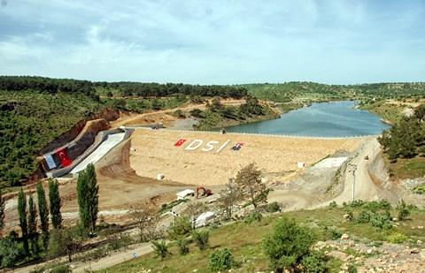
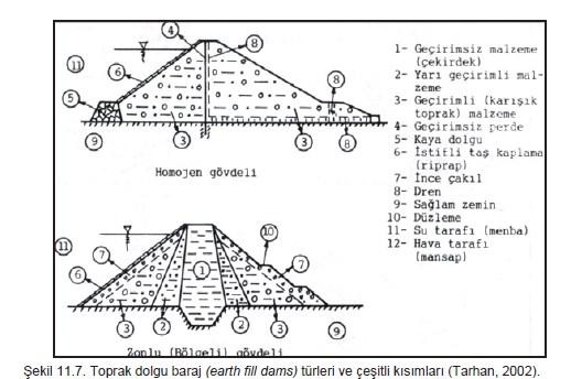
17 DAM TYPES Earth Fill Dams Soil dams are water-holding plants made by mixing soil and rock at a specific location. Such dams are preferred if the floor is not sufficiently strong and homogeneous. Wide and flat earthen dam in the valley is made. Classification of soil dams according to material used in dam body: Homogeneous body Regional Rock fill body Soil fill body Rock-soil body Homogeneous body is the same material on each side. The zoneed bodys have an impermeable part in the middle, a permeable part growing gradually outward on the two sides and a filter on the upstream and downstream heels. The rock fill bodies are made of broken stone. Sometimes the impermeable core is found and sometimes the upstream face is covered with an impermeable cover (clay, asphalt, steel, reinforced concrete, etc.).
18
19
20 EMBANKMENT DAMS (Rock Fill or Earth Fill Dams) They are mostly composed of natural materials such as, clay, sand, gravel etc... Impervious core is placed in the middle of the embankment body Generally riprap is used to control erosion Atatürk Dam Fırat River; Height= 169 m; Reservoir Capacity= 48,7 billion m 3

21 COMPOSITE DAMS Composite dams are combinations of one or more dam types. Most often a large section of a dam will be either an embankment or gravity dam, with the section responsible for power generation being a buttress or arch. Keban Dam Fırat River; Height= 163 m; Reservoir Capacity= 31 billion m 3 Gravity & Rock Fill
22 ENGINEERING GEOLOGICAL STUDIES IN THE DAM AND THE FACTORS AFFECTING THE SELECTION OF THE PLACE 1. Dam site features: The topography of the dam site, the geological structure of the basin and the slopes, the power of carrying, possible faults, cracks, alluvium thickness, full weir location and capacity, derivation conditions, transportation situation, dam distance of the material to be used in dam construction, 2. Lake area features: The topography and geological structure of the lake area, types of rocks, the thickness and impermeability of the rocks, the features of the lake area such as water retention, the stability of the lake slopes and the landslide condition are examined. 3. Hydraulic and hydrological characteristics of precipitation basin: The hydraulic, hydrological, meteorological and morphological characteristics of the precipitation basin should be investigated. Depending on the precipitation flow relationships in this framework, the amount of material flow, sediment accumulation, infiltration, evaporation, stream drainage system and vegetation cover of the river are examined. 4. Settlement, expropriation and costs associated with the renovation: Dam reservoir and settlement areas, industrial facilities, agricultural land, transportation roads, etc. that will be inundated in the region will be investigated. 5. Environmental impact: The effects of the dam on the climate and life conditions of the region, the protection of the groundwater balance for agriculture (salting), the submergence of historical sites and the deterioration of the natural structure of the region are examined.
23 FACTORS AFFECTING SELECTION OF DAM TYPE 1. Topographical situation of the dam site: The topography of the dam site is the first criterion to be taken into consideration in the selection of the dam type. 2. Foundation and geological structure: The foundation condition of the dam site is not suitable for each dam type. 3. Location and type of suitable material to be used in dam construction: There are three types of natural materials required for dam construction. These are aggregate for rock, concrete for soil, filler and riprap for filling. 4. Transportation facilities : If the dam site is close to existing roads, which reduces the cost of new road construction. Access to the material quarries is also important when selecting the dam site. 5. Translate (derivation) conditions : In order to be able to construct the dam under dry conditions, the upstream and downstream sides of the construction site should be suitable to be closed with low dams called altitude. 6. Full spillway capacity and location 7. Earthquake 8. Climatic conditions and duration of construction 9. Landslide: Large waves can be created from ground slopes of the dam to the landslide and the lake. 10. Economic situation of the country 11. Machine park area availability, types and capacities of machines
24 TOPOGRAPHIC SITUATION of DAM / Valley Factor: One of the important factors in the selection of the dam site is the valley shape. The valley types constitute an important criterion for determining the types of dams to be built on them. The shape of a valley, the valley in opening the geological units of properties, valley opens factor (glacial, river) valley height, the stream flow system, varies depending on the grooves in the stage of the valley formed phase. According to the shape and width of the valley, some dam types are not considered at all. For example, concrete arch dam is not made on a wide valley. It is considered to construct gravity or arch type dam if the valley consists unfolded, non broken rocks. Valley Types 1. Narrow V type 2. Wide V type 3. Narrow type 4. Wide U type
25 TOPOGRAPHIC STATUS of DAM site/ Valley Shape Factor: Where a dam is intended to be constructed, the ratio of the peak height to the maximum dam height is called the "valley factor" and is indicated by "K". Valley shapes and parts L = peak length of the dam; B = floor width of the valley; H = Dam height; U1 and U2 = Vertices made by the slope averages
26 TOPOGRAPHIC STATUS of DAM site/ Valley Shape Factor: Valleys is classified according to L / H ratio 1. Throat shaped valleys (L / H < 3), 2.Narrow valleys (3 < L / H < 6) 3. Wide valleys (L/H > 6). Throat shaped valleys allow the construction of thin or thick concrete arch dam If other factors are available in narrow U and V shaped valleys, the type of belt or weight is considered first. Rock filled or soil filled dams are considered to contruct on wide valleys. If height is available, contruction gravity dams is feasible alley factor (K), economic limit for concrete dam 5 in America; 7 in Italy; It is accepted as 11 in France. If it is greater than it, it requires that no concrete dam.
27 TOPOGRAPHIC SITUATION OF THE DAM / foundation geology and geological structure Solid rock foundations : They have a high carrying capacity, homogeneous and generally impermeable. They are suitable for all types of dams. On such bases, the dissociated surface rock must be stripped and the cracks must be blocked by injection. Gravel foundations : On these foundations, the carrying power is quite good, the seating quantities are negligible, but the permeability is high. These are generally not suitable for arches and splintered dams. If it is well-stuck cases, they are suitable for rock filled, soil filled and gravity dams. Since there may be a large amount of water infiltration, some leakage reducing measures must be taken. Silt or fine sand foundations: Erosion may occur on these bases, which have low strength, large settlements and high permeability. It is therefore suitable foundations for low concrete and soil filled dams. Basic settlement, Excessive infiltration loss and the carving of the downstream façade are important problems. Clay foundations: Their carrying capacity is very small, due to consolidation, the seating is very high and their permeability is low. Therefore, they are recommended only for low-earth fill dams. Such projects require special projects and experienced engineers
 is perpendicular to the axis of the dam, the water in the dam will escape out of the dam through the permeable rocks.")
28 TOPOGRAPHIC SITUATION OF THE DAM / Basic geological and geological structure Where the direction of discontinuities (stratum, cracks, etc.) is perpendicular to the axis of the dam, the water in the dam will escape out of the dam through the permeable rocks. Water leaks will occur in the strata of the "A", "B" and "C" specimens, which form oblique, horizontal and anticline structures respectively. If the permeability of these units is high, it will not be possible to collect water in the dam reservoir. The dam will run out to the sides and the dam will be empty. The underlying syncline structure, which is bounded below by the impermeable unit in section "D", will prevent groundwater from escaping to the sides. However, there will be fugitives from strata extending towards the dam downstream (perpendicular to the axis of the dam).
.")
29 TOPOGRAPHIC SITUATION OF THE DAM / Basic geological and geological structure The most appropriate stratification at the dam site to be chosen to prevent the water in the dam lake from escaping under the dam is a system consisting of layers inclined towards the dam lake (impermeable layer). In other words, the dam site is ideal if the dam body is impervious to layers and if the direction of the discontinuities is parallel to the axis of the dam and inclined towards the body. Accordingly, it is the ideal choice of dam site in terms of water retention.
30 TOPOGRAPHIC SITUATION OF THE DAM / Basic geological and geological structure
31 FORCES AFFECTING to DAM A dam must be able to withstand all static and dynamic forces acting on it. The most influential forces, 1. The dam's own weight 2. Hydrostatic water pressure 3. Base and pore pressure 4. Earthquake strength 5. Ice is the pressure.
32
33 1. RECONNAISSANCE STUDY 1. Evaluation of the data having at archives of MTA, DSI, EIE, Universities,...etc 2. Field investigation for limited time (Reconnaissance Study) 3. Some maps in small scale, for example 1/ or 1/ Some hydraulic data about a. Basin b. Precipitation area c. Runoff, maximum discharge {Q=R/t (m 3 /s)} d. Modulus of Runoff (R/t/m 2 ~ R/t/km 2 ) 5. Some approach to the reservoir area, dam site and type of dam and height of dam...etc 6. Photogeological studies 7. A preliminary report
34 2. PRELIMINARY STUDIES at the RESERVOIR AREA and DAM SITE 1. Dam site investigations 1. Location of dam axis 2. Location of diversion tunnel 3. Location of spillway 4. Location of powerhouse...etc 2. Geological studies 3. Geophysical surveying 4. Underground investigations 1. Boreholes 2. Investigation galleries 3. Pitholes 5. Surveying for materials 1. Field surveying 2. Laboratory tests
35 6. Slope stability investigations 7. Earthquake hazard & risk analysis 8. Environmental studies 9. Leakage possibilities from reservoir area 10. Leakage possibilities from dam site 11. Erosion, sedimentation & siltation
36 DETAILED INVESTIGATION at DAM SITE 1. Topographic surveyings 2. Geological mappings 1/5000 1/1000 or 1/ Underground explorations Boreholes, adits...etc 4. Hydrogeological studies 5. Slope stability analysis
37 FACTORS AFFECTING to the DAM TYPE SELECTION Topography Geology Bearing capacity of the underlying soil Foundation settlements Permeability of the foundation soil Material availability Spillway position Earthquakes Safety Height Aesthetic view Qualified labour Cost
38 FACTORS AFFECTING to the PLACE of the DAM AXIS Topography Geology Materials Spillway location availability Derivation Sediments in the flowing water Water quality Expropriation costs Earthquake possibility Downstream water rights
UGRC 144 Science and Technology in Our Lives/Geohazards
 UGRC 144 Science and Technology in Our Lives/Geohazards Flood and Flood Hazards Dr. Patrick Asamoah Sakyi Department of Earth Science, UG, Legon College of Education School of Continuing and Distance Education
GEOL 1121 Earth Processes and Environments
 GEOL 1121 Earth Processes and Environments Wondwosen Seyoum Department of Geology University of Georgia e-mail: seyoum@uga.edu G/G Bldg., Rm. No. 122 Seyoum, 2015 Chapter 6 Streams and Flooding Seyoum,
Phase II Report: Project Definition Options. Dam Safety
 OSHPC BARKI TOJIK Phase II Report: Project Definition Options Dam Safety Part 1: Basic data & Dam Design DAM Safety 2 Geology / Geotechnics...: Tectonics / Seismicity : DAM Design - Dam Location - Type
Surface Processes Focus on Mass Wasting (Chapter 10)
") Surface Processes Focus on Mass Wasting (Chapter 10) 1. What is the distinction between weathering, mass wasting, and erosion? 2. What is the controlling force in mass wasting? What force provides resistance?
Surface Processes Focus on Mass Wasting (Chapter 10) 1. What is the distinction between weathering, mass wasting, and erosion? 2. What is the controlling force in mass wasting? What force provides resistance?
Instructor : Dr. Jehad Hamad. Chapter (7)
") Instructor : Dr. Jehad Hamad Chapter (7) 2017-2016 Soil Properties Physical Properties Mechanical Properties Gradation and Structure Compressibility Soil-Water Relationships Shear Strength Bearing Capacity
Instructor : Dr. Jehad Hamad Chapter (7) 2017-2016 Soil Properties Physical Properties Mechanical Properties Gradation and Structure Compressibility Soil-Water Relationships Shear Strength Bearing Capacity
WHAT SEISMIC HAZARD INFORMATION THE DAM ENGINEERS NEED FROM SEISMOLOGISTS AND GEOLOGISTS?
 WHAT SEISMIC HAZARD INFORMATION THE DAM ENGINEERS NEED FROM SEISMOLOGISTS AND GEOLOGISTS? Martin WIELAND 1 ABSTRACT For large dam projects a site-specific seismic hazard analysis is usually recommended.
STRUCTURAL STABILITY ASSESSMENT
 STRUCTURAL STABILITY ASSESSMENT CFR 257.73(d) Bottom Ash Pond Complex Cardinal Plant Brilliant, Ohio October, 2016 Prepared for: Cardinal Operating Company Cardinal Plant Brilliant, Ohio Prepared by: Geotechnical
Science EOG Review: Landforms
 Mathematician Science EOG Review: Landforms Vocabulary Definition Term canyon deep, large, V- shaped valley formed by a river over millions of years of erosion; sometimes called gorges (example: Linville
CASE STUDY NATHPA JHAKRI, INDIA
 SEDIMENT MANAGEMENT CASE STUDY NATHPA JHAKRI, INDIA Key project features Name: Nathpa Jhakri Country: India Category: reduce sediment production (watershed management); upstream sediment trapping; bypass
Lecture Outlines PowerPoint. Chapter 5 Earth Science 11e Tarbuck/Lutgens
 Lecture Outlines PowerPoint Chapter 5 Earth Science 11e Tarbuck/Lutgens 2006 Pearson Prentice Hall This work is protected by United States copyright laws and is provided solely for the use of instructors
CASE STUDY NATHPA JHAKRI, INDIA
 SEDIMENT MANAGEMENT CASE STUDY NATHPA JHAKRI, INDIA Key project features Name: Nathpa Jhakri Country: India Category: reforestation/revegetation; upstream sediment trapping; bypass channel/tunnel; reservoir
Summary. Streams and Drainage Systems
 Streams and Drainage Systems Summary Streams are part of the hydrologic cycle and the chief means by which water returns from the land to the sea. They help shape the Earth s surface and transport sediment
Surface Water and Stream Development
 Surface Water and Stream Development Surface Water The moment a raindrop falls to earth it begins its return to the sea. Once water reaches Earth s surface it may evaporate back into the atmosphere, soak
Seismic Design of a Hydraulic Fill Dam by Nonlinear Time History Method
 Seismic Design of a Hydraulic Fill Dam by Nonlinear Time History Method E. Yıldız & A.F. Gürdil Temelsu International Engineering Services Inc., Ankara, Turkey SUMMARY: Time history analyses conducted
Michigan s Geology and Groundwater
 Michigan s Geology and Groundwater Ralph J. Haefner Deputy Director U.S. Geological Survey Michigan-Ohio Water Science Center Lansing, Michigan Outline About the USGS Geology 101 Michigan s geology Bedrock
Earth Science Chapter 9. Day 6 - Finish Capillary Action Lab - Quiz over Notes - Review Worksheets over Sections 9.2 and 9.3
 Earth Science Chapter 9 Day 1 Day 2 Day 3 Read Section 9.1 Surface Water Chapter 9 Term Sheet Notes over Section 9.1 Surface Water Section 9.1 Review Worksheets Quiz over Section 9.1 Notes Virtual Lab
Siva Bharatha Murthy. T Page 4.31
 Importance of Geological Structures: The physical properties of rocks, mineral and other materials of civil engineering, like textures, grain size are very important for a civil engineer. Similarly the
PROBLEMS AND SOLUTIONS THAT MAY EMERGE IN THE FOUNDATION AND BODY OF A HOMOGENEOUS FILL DAM ON A WEAK CLAYEY-SILTY-SANDY FORMATION ÇIKRIKÇI DAM
 PROBLEMS AND SOLUTIONS THAT MAY EMERGE IN THE FOUNDATION AND BODY OF A HOMOGENEOUS FILL DAM ON A WEAK CLAYEY-SILTY-SANDY FORMATION ÇIKRIKÇI DAM Esen Yalım KARADUMAN BAR-SU Eng. & Conc. Inc. Ankara Turkey
6.1 Water. The Water Cycle
 6.1 Water The Water Cycle Water constantly moves among the oceans, the atmosphere, the solid Earth, and the biosphere. This unending circulation of Earth s water supply is the water cycle. The Water Cycle
Prentice Hall EARTH SCIENCE
 Prentice Hall EARTH SCIENCE Tarbuck Lutgens Running Water and Groundwater Running Water The Water Cycle Water constantly moves among the oceans, the atmosphere, the solid Earth, and the biosphere. This
Seepage Analysis for Shurijeh Reservoir Dam Using Finite Element Method. S. Soleymani 1, A. Akhtarpur 2
 Seepage Analysis for Shurijeh Reservoir Dam Using Finite Element Method S. Soleymani 1, A. Akhtarpur 2 1 Group of Dam Construction, Toossab Company, P.O. Box 917751569, Mashhad City, Iran, PH (+98) 511-7684091;
Hydraulic Structures. Notes and Handouts
 Hydraulic Structures Notes and Handouts Introduction Free surface flows in particular often have hydraulic structures to control flow Dams Spillways Stilling Basins Weirs Gates Can have hydraulic/structural/geotechnical
STUDY GUIDE FOR CONTENT MASTERY. Surface Water Movement
 Surface Water SECTION 9.1 Surface Water Movement In your textbook, read about surface water and the way in which it moves sediment. Complete each statement. 1. An excessive amount of water flowing downslope
Engineer. Engineering. Engineering. (in-ja-neer ) A person trained and skilled in any of the various branches of engineering: a civil engineer
 A person trained and skilled in any of the various branches of engineering: a civil engineer") Engineer (in-ja-neer ) A person trained and skilled in any of the various branches of engineering: a civil engineer (Random House Webster s College Dictionary, 1991) CE100 Introduction to Civil Geotechnical
Engineer (in-ja-neer ) A person trained and skilled in any of the various branches of engineering: a civil engineer (Random House Webster s College Dictionary, 1991) CE100 Introduction to Civil Geotechnical
mountain rivers fixed channel boundaries (bedrock banks and bed) high transport capacity low storage input output
 high transport capacity low storage input output") mountain rivers fixed channel boundaries (bedrock banks and bed) high transport capacity low storage input output strong interaction between streams & hillslopes Sediment Budgets for Mountain Rivers Little
mountain rivers fixed channel boundaries (bedrock banks and bed) high transport capacity low storage input output strong interaction between streams & hillslopes Sediment Budgets for Mountain Rivers Little
WATER ON AND UNDER GROUND. Objectives. The Hydrologic Cycle
 WATER ON AND UNDER GROUND Objectives Define and describe the hydrologic cycle. Identify the basic characteristics of streams. Define drainage basin. Describe how floods occur and what factors may make
Mass Wasting. Requirements for Mass Wasting. Slope Stability. Geol 104: mass wasting
 Mass Wasting Movement of earth materials downslope, driven by Gravitational Forces. Landslides - general term for rock or soil movement. In U.S., on average, mass wasting causes 1 to 2 billion dollars
LOCATIONS OF SELECTED MITIGATION SITES IN JAPAN
 LOCATIOS OF SELECTED MITIGATIO SITES I JAPA Hyogo prefecture near Kobe, Japan Hyogo province Gifu province Osaka Kobe Gifu prefecture near Takayama, Japan akao Kamikochi ational Park Mount Yake Tateyama
3.12 Geology and Topography Affected Environment
 3 Affected Environment and Environmental Consequences 3.12 Geology and Topography 3.12.1 Affected Environment 3.12.1.1 Earthquakes Sterling Highway MP 45 60 Project Draft SEIS The Kenai Peninsula is predisposed
Rock Sizing for Small Dam Spillways
 Rock Sizing for Small Dam Spillways STORMWATER MANAGEMENT PRACTICES Photo 1 Rock-lined spillway on a construction site sediment basin Photo 2 Rock-lined spillway on a small farm dam 1. Introduction A chute
Streams. Water. Hydrologic Cycle. Geol 104: Streams
 Streams Why study streams? Running water is the most important geologic agent in erosion, transportation and deposition of sediments. Water The unique physical and chemical properties of water make it
Suspended sediment yields of rivers in Turkey
 Erosion and Sediment Yield: Global and Regional Perspectives (Proceedings of the Exeter Symposium, July 1996). IAHS Publ. no. 236, 1996. 65 Suspended sediment yields of rivers in Turkey FAZLI OZTURK Department
11/12/2014. Running Water. Introduction. Water on Earth. The Hydrologic Cycle. Fluid Flow
 Introduction Mercury, Venus, Earth and Mars share a similar history, but Earth is the only terrestrial planet with abundant water! Mercury is too small and hot Venus has a runaway green house effect so
Prof. B V S Viswanadham, Department of Civil Engineering, IIT Bombay
 13 Permeability and Seepage -2 Conditions favourable for the formation quick sand Quick sand is not a type of sand but a flow condition occurring within a cohesion-less soil when its effective stress is
b Blackwell Science Environmental Geology PRINCIPLES AND PRACTICE
 Environmental Geology PRINCIPLES AND PRACTICE Fred G. Bell Department of Geology and Applied Geology University of Natal, Durban, South Africa b Blackwell Science Preface, ix 1 Introduction, 1 1.1 Planning
Practical aspects of dam break analysis
 Practical aspects of dam break analysis Louis C Hattingh Hattingh Anderson Associates CC Dam break analysis It is a model You need to understand what you model & have an idea of the answers that you expect
Modeling Great Britain s Flood Defenses. Flood Defense in Great Britain. By Dr. Yizhong Qu
 Modeling Great Britain s Flood Defenses AIRCurrents Editor s note: AIR launched its Inland Flood Model for Great Britain in December 2008. The hazard module captures the physical processes of rainfall-runoff
Stream Geomorphology. Leslie A. Morrissey UVM July 25, 2012
 Stream Geomorphology Leslie A. Morrissey UVM July 25, 2012 What Functions do Healthy Streams Provide? Flood mitigation Water supply Water quality Sediment storage and transport Habitat Recreation Transportation
Rock Sizing for Waterway & Gully Chutes
 Rock Sizing for Waterway & Gully Chutes WATERWAY MANAGEMENT PRACTICES Photo 1 Rock-lined waterway chute Photo 2 Rock-lined gully chute 1. Introduction A waterway chute is a stabilised section of channel
Earth Science Chapter 6 Section 2 Review
 Name: Class: Date: Earth Science Chapter 6 Section Review Multiple Choice Identify the choice that best completes the statement or answers the question. 1. Most streams carry the largest part of their
*** ***! " " ) * % )!( & ' % # $. 0 1 %./ +, - 7 : %8% 9 ) 7 / ( * 7 : %8% 9 < ;14. " > /' ;-,=. / ١
 * % )!( & ' % # $. 0 1 %./ +, - 7 : %8% 9 ) 7 / ( * 7 : %8% 9 < ;14. > /' ;-,=. / ١") ١ ******!" #$ % & '!( ) % * ") +,-./ % 01. 3 ( 4 56 7/4 ) 8%9 % : 7 ;14 < 8%9 % : *7./ = ;-, >/'." Soil Permeability & Seepage ٢ Soil Permeability- Definition ٣ What is Permeability? Permeability is the
١ ******!" #$ % & '!( ) % * ") +,-./ % 01. 3 ( 4 56 7/4 ) 8%9 % : 7 ;14 < 8%9 % : *7./ = ;-, >/'." Soil Permeability & Seepage ٢ Soil Permeability- Definition ٣ What is Permeability? Permeability is the
ENGINEERING HYDROLOGY
 ENGINEERING HYDROLOGY Prof. Rajesh Bhagat Asst. Professor Civil Engineering Department Yeshwantrao Chavan College Of Engineering Nagpur B. E. (Civil Engg.) M. Tech. (Enviro. Engg.) GCOE, Amravati VNIT,
Which map shows the stream drainage pattern that most likely formed on the surface of this volcano? A) B)
 B)") 1. When snow cover on the land melts, the water will most likely become surface runoff if the land surface is A) frozen B) porous C) grass covered D) unconsolidated gravel Base your answers to questions
1. When snow cover on the land melts, the water will most likely become surface runoff if the land surface is A) frozen B) porous C) grass covered D) unconsolidated gravel Base your answers to questions
Site Investigation and Landfill Construction I
 Site Investigation and Landfill Construction I Gernot Döberl Vienna University of Technology Institute for Water Quality, Resources and Waste Management Contents Site Investigation Base Liners Base Drainage
Running Water Earth - Chapter 16 Stan Hatfield Southwestern Illinois College
 Running Water Earth - Chapter 16 Stan Hatfield Southwestern Illinois College Hydrologic Cycle The hydrologic cycle is a summary of the circulation of Earth s water supply. Processes involved in the hydrologic
 12 10 8 6 4 2 0 40-50 50-60 60-70 70-80 80-90 90-100 Fresh Water What we will cover The Hydrologic Cycle River systems Floods Groundwater Caves and Karst Topography Hot springs Distribution of water in
Dams may either be human-built or result from natural phenomena, such as
 Chapter 1 Dam failures C. Deangeli 1, G.P. Giani 2, B. Chiaia 1 & A.P. Fantilli 1 1 Politecnico di Torino, Turin, Italy 2 State University of Milan, Milan, Italy Abstract Dams may either be human-built
C) D) 3. Which graph best represents the relationship between soil particle size and the rate at which water infiltrates permeable soil?
 D) 3. Which graph best represents the relationship between soil particle size and the rate at which water infiltrates permeable soil?") 1. Which earth material covering the surface of a landfill would permit the least amount of rainwater to infiltrate the surface? A) silt B) clay C) sand D) pebbles 2. Which graph best represents the relationship
1. Which earth material covering the surface of a landfill would permit the least amount of rainwater to infiltrate the surface? A) silt B) clay C) sand D) pebbles 2. Which graph best represents the relationship
Erosion Surface Water. moving, transporting, and depositing sediment.
 + Erosion Surface Water moving, transporting, and depositing sediment. + Surface Water 2 Water from rainfall can hit Earth s surface and do a number of things: Slowly soak into the ground: Infiltration
5. Which surface soil type has the slowest permeability rate and is most likely to produce flooding? A) pebbles B) sand C) silt D) clay A) B) C) D)
 pebbles B) sand C) silt D) clay A) B) C) D)") 1. During a heavy rainstorm, soil samples A and B both became saturated with water. However, 10 minutes after the storm ended, the soils appeared as shown below. Which statement best explains the observed
1. During a heavy rainstorm, soil samples A and B both became saturated with water. However, 10 minutes after the storm ended, the soils appeared as shown below. Which statement best explains the observed
Term Knowledge Using and applying Grade Criteria Autumn 1 Assessment window October Natural hazards pose major risks to people and property.
 Assessment Schedule Year 9 2015/6 Term Knowledge Using and applying Grade Criteria Autumn 1 Assessment window October 2015 3.1.1.2 Tectonic Natural hazards pose major risks to people and property. Definition
EPS 50 - Lab 10: Groundwater Flow and Glaciers
 Name: EPS 50 - Lab 10: Groundwater Flow and Glaciers Part 1: Groundwater Flow Part 2: Darcy s Law Part 3: Glacial Deposits and Flow -Chapter 17, p. 478-492: Hydrology of Groundwater -Chapter 17, p. 485-486:
Influence of the Major Drainages to the Mississippi River and Implications for System Level Management
 Influence of the Major Drainages to the Mississippi River and Implications for System Level Management Brian M. Vosburg Geologist Louisiana Coastal Protection and Restoration Authority brian.vosburg@la.gov
Evaluation of Subsurface Formation of Pabna District, Bangladesh
 IOSR Journal of Applied Geology and Geophysics (IOSR-JAGG) e-issn: 2321 0990, p-issn: 2321 0982.Volume 1, Issue 4 (Sep. Oct. 2013), PP 30-36 Evaluation of Subsurface Formation of Pabna District, Bangladesh
Civil Engineering Department College of Engineering
 Civil Engineering Department College of Engineering Course: Soil Mechanics (CE 359) Lecturer: Dr. Frederick Owusu-Nimo FREQUENCY CE 260 Results (2013) 30 25 23 25 26 27 21 20 18 15 14 15 Civil Geological
AN APPROACH TO THE CLASSIFICATION OF SLOPE MOVEMENTS
 Training/workshop on Earthquake Vulnerability and Multi-Hazard Risk Assessment: Geospatial Tools for Rehabilitation and Reconstruction Effort 13 31 March 2006, Islamabad, Pakistan AN APPROACH TO THE CLASSIFICATION
GEOTECHNICAL ENGINEERING II. Subject Code : 06CV64 Internal Assessment Marks : 25 PART A UNIT 1
 GEOTECHNICAL ENGINEERING II Subject Code : 06CV64 Internal Assessment Marks : 25 PART A UNIT 1 1. SUBSURFACE EXPLORATION 1.1 Importance, Exploration Program 1.2 Methods of exploration, Boring, Sounding
STREAM SYSTEMS and FLOODS
 STREAM SYSTEMS and FLOODS The Hydrologic Cycle Precipitation Evaporation Infiltration Runoff Transpiration Earth s Water and the Hydrologic Cycle The Hydrologic Cycle The Hydrologic Cycle Oceans not filling
Precipitation Evaporation Infiltration Earth s Water and the Hydrologic Cycle. Runoff Transpiration
 STREAM SYSTEMS and FLOODS The Hydrologic Cycle Precipitation Evaporation Infiltration Earth s Water and the Hydrologic Cycle Runoff Transpiration The Hydrologic Cycle The Hydrologic Cycle Oceans not filling
Continuing Education Associated with Maintaining CPESC and CESSWI Certification
 Continuing Education Associated with Maintaining CPESC and CESSWI Certification Module 2: Stormwater Management Principles for Earth Disturbing Activities Sponsors: ODOTs Local Technical Assistance Program
Materials. Use materials meeting the following.
 208.01 Section 208. SOIL EROSION AND SEDIMENTATION CONTROL 208.01 Description. Install and maintain erosion and sedimentation controls to minimize soil erosion and to control sedimentation from affecting
INFLOW DESIGN FLOOD CONTROL SYSTEM PLAN 40 C.F.R. PART PLANT YATES ASH POND 2 (AP-2) GEORGIA POWER COMPANY
 GEORGIA POWER COMPANY") INFLOW DESIGN FLOOD CONTROL SYSTEM PLAN 40 C.F.R. PART 257.82 PLANT YATES ASH POND 2 (AP-2) GEORGIA POWER COMPANY EPA s Disposal of Coal Combustion Residuals from Electric Utilities Final Rule (40 C.F.R.
INFLOW DESIGN FLOOD CONTROL SYSTEM PLAN 40 C.F.R. PART 257.82 PLANT YATES ASH POND 2 (AP-2) GEORGIA POWER COMPANY EPA s Disposal of Coal Combustion Residuals from Electric Utilities Final Rule (40 C.F.R.
Year 6. Geography. Revision
 Year 6 Geography Revision November 2017 Rivers and World knowledge How the water cycle works and the meaning of the terms evaporation, condensation, precipitation, transpiration, surface run-off, groundwater
Birecik Dam & HEPP Downstream River Arrangement R. Naderer, G. Scharler Verbundplan GmbH, 5021 Salzburg, Austria
 Birecik Dam & HEPP Downstream River Arrangement R. Naderer, G. Scharler Verbundplan GmbH, 5021 Salzburg, Austria e-mail: scharlerg@verbund.co.at Abstract Birecik Dam & HEPP on the Euphrates river in Turkey
How Do Human Impacts and Geomorphological Responses Vary with Spatial Scale in the Streams and Rivers of the Illinois Basin?
 How Do Human Impacts and Geomorphological Responses Vary with Spatial Scale in the Streams and Rivers of the Illinois Basin? Bruce Rhoads Department of Geography University of Illinois at Urbana-Champaign
IAEA SAFETY STANDARDS Geotechnical Aspects of Site Evaluation and Foundations in NPPs, NS-G-3.6
 IAEA SAFETY STANDARDS Geotechnical Aspects of Site Evaluation and Foundations in NPPs, NS-G-3.6 Regional Workshop on Volcanic, Seismic, and Tsunami Hazard Assessment Related to NPP Siting Activities and
NC Earth Science Essential Standards
 NC Earth Science Essential Standards EEn. 2.1 Explain how processes and forces affect the Lithosphere. EEn. 2.1.1 Explain how the rock cycle, plate tectonics, volcanoes, and earthquakes impact the Lithosphere.
What is weathering and how does it change Earth s surface? Answer the question using
 7 th Grade Lesson What is weathering and how does it change Earth s surface? Answer the question using the sentence frame. You have 4 minutes. Weathering is. This changes the Earth s surface because. 1
TEACHER BACKGROUND KNOWLEDGE. Surface Processes: Weathering and Erosion
 TEACHER BACKGROUND KNOWLEDGE Surface Processes: Weathering and Erosion Core Concepts Precipitation (caused by the water cycle) and wind cause rocks to be broken into smaller pieces in the process called
The Hydrologic Cycle STREAM SYSTEMS. Earth s Water and the Hydrologic Cycle. The Hydrologic Cycle. Hydrologic Cycle
 STREAM SYSTEMS Earth Science: Chapter 5 Reading pages 114-124 The Hydrologic Cycle Oceans not filling up Evaporation = precipitation System is balanced Earth s Water and the Hydrologic Cycle Earth s Water
Landslide FE Stability Analysis
 Landslide FE Stability Analysis L. Kellezi Dept. of Geotechnical Engineering, GEO-Danish Geotechnical Institute, Denmark S. Allkja Altea & Geostudio 2000, Albania P. B. Hansen Dept. of Geotechnical Engineering,
Instream Sediment Control Systems
 Instream Sediment Control Systems INSTREAM PRACTICES Photo 1 Photo 2 Modular sediment The information contained within this series of fact sheets deals only with the design of temporary instream sediment
Surface Water Short Study Guide
 Name: Class: Date: Surface Water Short Study Guide Multiple Choice Identify the letter of the choice that best completes the statement or answers the question. 1. The three ways in which a stream carries
APPENDIX B WORKSHEETS & EXHIBITS
 APPENDIX B WORKSHEETS & EXHIBITS A worksheet provides the designer a representation of a measure that allows for input of specific design criteria. The plan designer will be required to assess field conditions
[1] Performance of the sediment trap depends on the type of outlet structure and the settling pond surface area.
![[1] Performance of the sediment trap depends on the type of outlet structure and the settling pond surface area.](/thumbs/76/74245181.jpg "[1] Performance of the sediment trap depends on the type of outlet structure and the settling pond surface area.") Sediment Trench SEDIMENT CONTROL TECHNIQUE Type 1 System Sheet Flow Sandy Soils Type 2 System [1] Concentrated Flow Clayey Soils Type 3 System [1] Supplementary Trap Dispersive Soils [1] Performance of
Sediment Trench SEDIMENT CONTROL TECHNIQUE Type 1 System Sheet Flow Sandy Soils Type 2 System [1] Concentrated Flow Clayey Soils Type 3 System [1] Supplementary Trap Dispersive Soils [1] Performance of
Chapter 3 Erosion and Deposition. The Big Question:
 Chapter 3 Erosion and Deposition The Big Question: 1 Design a way to represent and describe the 4 types of mass movement. You may use pictures, diagrams, list, web, chart, etc 2 Chapter 3: Erosion and
SPECIFIC DEGRADATION AND RESERVOIR SEDIMENTATION. By Renee Vandermause & Chun-Yao Yang
 SPECIFIC DEGRADATION AND RESERVOIR SEDIMENTATION By Renee Vandermause & Chun-Yao Yang Outline Sediment Degradation - Erosion vs Sediment Yield - Sediment Yield - Methods for estimation - Defining Sediment
Flash flood disaster in Bayangol district, Ulaanbaatar
 Flash flood disaster in Bayangol district, Ulaanbaatar Advanced Training Workshop on Reservoir Sedimentation Management 10-16 October 2007. IRTCES, Beijing China Janchivdorj.L, Institute of Geoecology,MAS
The 2011 Tohoku earthquake and dams
 The 2011 Tohoku earthquake and dams N. Matsumoto & T. Sasaki Japan Dam Engineering Center, Japan T. Ohmachi Tokyo Institute of Technology, Japan ABSTRACT: The magnitude 9.0 Tohoku earthquake occurred on
In the space provided, write the letter of the description that best matches the term or phrase. a. any form of water that falls to Earth s
 Skills Worksheet Concept Review In the space provided, write the letter of the description that best matches the term or phrase. 1. condensation 2. floodplain 3. watershed 4. tributary 5. evapotranspiration
Each basin is surrounded & defined by a drainage divide (high point from which water flows away) Channel initiation
 Channel initiation") DRAINAGE BASINS A drainage basin or watershed is defined from a downstream point, working upstream, to include all of the hillslope & channel areas which drain to that point Each basin is surrounded &
DRAINAGE BASINS A drainage basin or watershed is defined from a downstream point, working upstream, to include all of the hillslope & channel areas which drain to that point Each basin is surrounded &
Name: KEY OBJECTIVES HYDROLOGY:
 Name: KEY OBJECTIVES Correctly define: abrasion, capillarity, deposition, discharge, erosion, evapotranspiration, hydrology, impermeable, infiltration, meander, permeable, porosity, water table, weathering,
3/8/17. #20 - Landslides: Mitigation and Case Histories. Questions for Thought. Questions for Thought
 #20 - Landslides: Mitigation and Case Histories Web Exercise #3 (Volcanoes) Due Wednesday There is a 2-point penalty for every day the assignment is late. Exam 1 Scores Scores and exam key are posted Vaiont
Ecoregions Glossary. 7.8B: Changes To Texas Land Earth and Space
 Ecoregions Glossary Ecoregions The term ecoregions was developed by combining the terms ecology and region. Ecology is the study of the interrelationship of organisms and their environments. The term,
RESERVOIR DRAWDOWN RATES/RESERVOIR DRAWDOWN TEST Iron Gate, Copco (I & II), and JC Boyle Dams
, and JC Boyle Dams") TECHNICAL MEMORANDUM No. 1 TO: Michael Bowen California Coastal Conservancy Geotechnical & Earthquake Engineering Consultants CC: Eric Ginney Philip Williams & Associates PREPARED BY: Paul Grant SUBJECT:
TECHNICAL MEMORANDUM No. 1 TO: Michael Bowen California Coastal Conservancy Geotechnical & Earthquake Engineering Consultants CC: Eric Ginney Philip Williams & Associates PREPARED BY: Paul Grant SUBJECT:
Seismic Analyses of Concrete Gravity Dam with 3D Full Dam Model
 Seismic Analyses of Concrete Gravity Dam with 3D Full Dam Model Haibo Wang, Deyu Li & Huichen Yang China Institute of Water Resources and Hydropower Research, Beijing, China SUMMARY: Seismic analyses of
How & Where does infiltration work? Summary of Geologic History Constraints/benefits for different geologic units
 June 26, 2007: Low Impact Development 1 Associated Earth Sciences, Inc. Associated Earth Sciences, Inc. Presented by: Matthew A. Miller, PE April 24, 2012 How & Where does infiltration work? Summary of
Assessment of solid load and siltation potential of dams reservoirs in the High Atlas of Marrakech (Moorcco) using SWAT Model
 using SWAT Model") Assessment of solid load and siltation potential of dams reservoirs in the High Atlas of Marrakech (Moorcco) using SWAT Model Amal Markhi: Phd Student Supervisor: Pr :N.Laftrouhi Contextualization Facing
Assessment of solid load and siltation potential of dams reservoirs in the High Atlas of Marrakech (Moorcco) using SWAT Model Amal Markhi: Phd Student Supervisor: Pr :N.Laftrouhi Contextualization Facing
Subject Name: SOIL AND WATER CONSERVATION ENGINEERING 3(2+1) COURSE OUTLINE
 COURSE OUTLINE") Subject Name: SOIL AND WATER CONSERVATION ENGINEERING 3(2+1) COURSE OUTLINE (Name of Course Developer: Prof. Ashok Mishra, AgFE Department, IIT Kharagpur, Kharagpur 721 302) Module 1: Introduction and
Subject Name: SOIL AND WATER CONSERVATION ENGINEERING 3(2+1) COURSE OUTLINE (Name of Course Developer: Prof. Ashok Mishra, AgFE Department, IIT Kharagpur, Kharagpur 721 302) Module 1: Introduction and
Geography Notes for Plonk Meeting
 Geography Notes for Plonk Meeting Hydrologic Cycle 1. Rainfall Water falls as rain or snow if the air is cold enough. 2. Groundwater Water that seeps into the ground may be absorbed by plants or flow into
Chapter 2: Landslides and Debris Flows
 Chapter 2: Landslides and Debris Flows Chapter 2: Landslides and Debris Flows Landslides and debris flows are among the major causes of flash floods in the Himalayan region as the rock, earth, debris,
Geotechnical Engineering and Dams
 Geotechnical Engineering and Dams Solving Geotechnical Challenges for Hydropower and Water Resources Projects Geological and geotechnical challenges are often very demanding when planning hydraulic structures.
GEOL.3250 Geology for Engineers Glacial Geology
 GEOL.3250 Geology for Engineers Glacial Geology NAME Part I: Continental Glaciation Continental glaciers are large ice sheets that cover substantial portions of the land area. In the region of accumulation
NUMERICAL ANALYSIS OF CONCRETE FACED ROCKFILL DAMS DURING EARTHQUAKES
 Paper No. NASTU NUMERICAL ANALYSIS OF CONCRETE FACED ROCKFILL DAMS DURING EARTHQUAKES Sinan TURKMEN 1, Kutay OZAYDIN 2, Mehmet BERILGEN 3, Havvanur KILIC 4 ABSTRACT In this study, the seismic behavior
Dams, sediment, and channel changes and why you should care
 Dams, sediment, and channel changes and why you should care Gordon E. Grant USDA Forest Service PNW Research Station Corvallis, Oregon Dam effects on river regimes FLOW (Q) SEDIMENT (Qs) TEMP CHEMISTRY
RIVERS, GROUNDWATER, AND GLACIERS
 RIVERS, GROUNDWATER, AND GLACIERS Delta A fan-shaped deposit that forms when a river flows into a quiet or large body of water, such as a lake, an ocean, or an inland sea. Alluvial Fan A sloping triangle
What are the different ways rocks can be weathered?
 Romano - 223 What are the different ways rocks can be weathered? Weathering - the breakdown of rocks and minerals at the Earth s surface 1. 2. PHYSICAL WEATHERING Rock is broken into smaller pieces with
Flooding in Dolgellau
 Flooding in Dolgellau Graham Hall MMath, PhD University of Wales, Bangor Background Flooding has historically been a cause for concern in Dolgellau. Following a serious flood in December 1964 when shops
EARTH SCIENCE 11 CHAPTER 9 NOTES WATER MOVING UNDERGROUND
 EARTH SCIENCE 11 CHAPTER 9 NOTES WATER MOVING UNDERGROUND KEY A. ALL THE WORLD S WATER 1. The world has an estimated one and one third thousand million cubic kilometers of water. 2. The earth s water is
R.M.HARW & ASSOCIATES LTD. GEOTECHNICAL INVESTIGATION PROPOSED BRIDGE SITE. HELAVA CREEKl MILE MACKENZIE HIGHWAY E-2510 OCTOBER 16, 1973
 El R.M.HARW & ASSOCIATES LTD. GEOTECHNICAL INVESTIGATION PROPOSED BRIDGE SITE HELAVA CREEKl MILE 616.4 MACKENZIE HIGHWAY E-2510 OCTOBER 16, 1973 R,M,HARDV & ASSOCIATES LTD. CONSULTING ENGINEERING & TESTING