A Geohazard Information Service for Europe.
|
|
|
- Abner Willis
- 5 years ago
- Views:
Transcription


1 A Geohazard Information Service for Europe
2 Overview PanGeo is an online service that provides users with open access to geohazard information across European cities and towns down to a mapping scale of 1:10,000. Geohazards are natural and man-made phenomena that make the ground unstable and in a built environment can be both costly and dangerous. PanGeo s unique geohazard products have been created to improve decision making and reduce risk. What are Geohazards? In PanGeo, the geohazards include: earthquakes, landslides, mineral workings, groundwater abstraction and recharge, shrink and swell clays, soluble rocks, compressible ground, collapsible deposits, landfill and rockfall. Many of these geohazards manifest as subsidence. Who is PanGeo aimed at? Local Authorities National Geological Surveys EU and EC policy makers Commercial businesses The Public Which towns are included? To date PanGeo covers 52 major towns and cities across 27 European countries which represents approximately 13% of the EU population. The vision for PanGeo is to increase our coverage within Europe to incorporate many more. How is the service accessed? Go to to view towns and cities already available online. Navigate to Access to PanGeo Data and follow the instructions. All information is accessible online. If you are interested in having PanGeo products generated for your town or city, please visit our website and either click on PanGeo My Town or the contact team for further information and conditions.
3 Service PanGeo provides open access* to validated and INSPIRE compliant geohazard products for cities and towns. Products are generated by the European geological surveys; using satellite derived terrain motion data and integrated with geological information. Service products: Ground Stability Layer (GSL) which maps, using attributed vector polygons, all the areas of a given town that are affected by terrain motion. Geohazard Description (GHD) a document that describes the geological reasons for the discovered motions. Access to Service Access to the GSL and the GHD for a town is via the PanGeo website (). A user can view the data on the PanGeo portal, built on One Geology Europe infrastructure, or via Google Earth. Upon user enquiry the portal retrieves information on individual town GSL polygons and automatically integrates it with the Urban Atlas dataset. The products can be downloaded and integrated into a user s own system. The future for PanGeo is to increase the service provision to include new towns across Europe in a sustainable manner. * free access to sites produced as part of the PanGeo EC FP7 Copernicus project. Service Mechanics Terrain motion data Geology Other data eg. Topographic Hydrological Infrastructure Geological Survey Interpretation INDIVIDUAL TOWN GSL GHD VALIDATION TOWNS URBAN ATLAS PORTAL AND GOOGLE TM EARTH VISUALISATION UPON USER ENQUIRY THE PORTAL RETRIEVES TOWN INFORMATION

 displays areas of ground motion as a consequence of the natural compaction of")

 Screen shot of PanGeo Portal. Ground Stability Layers visualized in Google TM Earth.")
4 The PanGeo Product for Rome In the framework of PanGeo, The Geological Survey of Italy (ISPRA) in collaboration with the Urban Planning Department of Roma Capitale has developed a detailed Geohazard map of Rome. The analysis of Roma Capitale has identified 31 areas of geological hazard, divided between observed hazards and potentially dangerous geological hazards. The largest polygon corresponds to volcanic (uplift) of the Latium volcano. The Tiber River and its tributaries (which comprises potentially compressible ground of soft alluvial deposit) displays areas of ground motion as a consequence of the natural compaction of unconsolidated sediments combined with anthropogenic factors. PanGeo has facilitated an improved knowledge of geohazards in the Roma territorial municipality. The knowledge of geohazards is mandatory to establish appropriate mitigation measures both for existing man-made structures and for urban planning purposes. PanGeo provides a positive stimulus for developing critical knowledge and practical applications for better management of the urban environment. Source: Roma Capitale. A sink hole in Stazione San Pietro street ( Screen shot of PanGeo Portal. Ground Stability Layers visualized in Google TM Earth. 1:10,000 scale plan with GSL overlaid on Piano Regolatore Vigente, serie 3* - Sistemi e Regole. Adapted from: Succhiarelli C., et al., 2013, Il Progetto Europeo PanGeo: monitoraggio dei movimenti del suolo urbanizzato di Roma Capitale mediante dati satellitari PSI. 14a Conferenza Italiana Utenti ESRI; Comerci et al., 2013, Geohazard Description for Rome. PanGeo Project.

5 Benefits of PanGeo Improved knowledge of geohazards Open access to geohazard information Validated products within an INSPIRE compliant service Products can be easily ingested into users own systems Development of productive collaboration between users and Geological Surveys Incorporate landcover use and population statistics Screenshot of PanGeo GSL on Palermo, Italy and surrounding areas visualised in Google TM Earth. Value statements PanGeo products provide important indications and highlight potential geohazard areas where Local Authorities should focus activities. Source: Roma Capitale. PanGeo information is very pertinent for use in urban planning documents concerning potential exposure of population at risk. Source: AUAT (Toulouse). The PanGeo service is considered suitable for Space Planning and Disaster Preparedness. Source: Roma Capitale. Integration with other programmes Integration with complementary datasets including the Urban Atlas land use and population data. This aids generation of further statistics. The statistics are a powerful outcome of the PanGeo project enabling geohazards to be related to land use and population. Source: British Geological Survey
1732 865023 The research leading to these results has received funding from the")
, UK Landmark Information Group, UK TNO, Netherlands Systèmes d information à Référence")


, Hungary Department of Communications, Energy and Natural Resources, Ireland Istituto Superiore per la Protezione e")

6 Contact Team Claire Roberts Carole Holway NPA Satellite Mapping Crockham Park Edenbridge Kent TN8 6SR, UK Tel: +44 (0) The research leading to these results has received funding from the European Union Seventh Framework Programme (FP7/ ) under grant agreement n Core Team NPA Satellite Mapping, UK British Geological Survey (NERC), UK Landmark Information Group, UK TNO, Netherlands Systèmes d information à Référence Spatiale, France Consorci Institut de Geomàtica, Spain Bureau de Recherches Géologiques et Minières, France EuroGeoSurveys, Belgium European Federation of Geologists, Belgium AB Consulting, UK Tele-Rilevamento Europa T.R.E. s.r.l., Italy Gamma Remote Sensing, Switzerland Altamira Information, Spain Geological Survey Team Geologische Bundesanstalt, Austria Institut Royal des Sciences Naturellesde Belgique, RBINS, Belgium University of Mining and Geology St. Ivan Rilski, Bulgaria Ministry of Agriculture, Natural Resources and Environment,Cyprus Ceska Geologicka Sluzba, Czech Republic Geological Survey of Denmark and Greenland Eesti Geoloogiakeskus, OÜ, Estonia Geologian tutkimuskeskus, Finland BGR, Germany Ethniko Kentro Viosimis Kai Aeiforou Anaptyxis, EKBAA-IGME, Greece Magyar Földtani és Geofizikai Intézet (MFGI), Hungary Department of Communications, Energy and Natural Resources, Ireland Istituto Superiore per la Protezione e la Ricerca Ambientale, ISPRA, Italy Latvijas Universitate, Latvia Lietuvos geologijos tarnyba prie Aplinkos ministerijos, LGT, Lithuania Service Géologique du Luxembourg, Luxembourg Malta Resources Authority, Malta Panstwowy Instytut Geologiczny, Poland Laboratório Nacional de Energia e Geologia, I. P., Portugal Institutul Geologic al Romaniei, Romania Statny Geologicky Ustav Dionyza Stura, Slovakia Geološki zavod Slovenije, Slovenia Istituto Geológico y Minero de España, Spain Sveriges Geologiska Undersokning, Sweden
EMODne Entry Portal Steering Committee, Brussels, 16 December Alan Stevenson, Jonathan Lowndes (British Geological Survey) and the project team
 and the project team") EMODnet Geology EMODne Entry Portal Steering Committee, Brussels, 16 December 2013 Alan Stevenson, Jonathan Lowndes (British Geological Survey) and the project team Background 14 organisations participated
EMODnet Geology EMODne Entry Portal Steering Committee, Brussels, 16 December 2013 Alan Stevenson, Jonathan Lowndes (British Geological Survey) and the project team Background 14 organisations participated
LCA/RMF/MFA. Some elements
 LCA/RMF/MFA Some elements Position of the question The metals cycles The metals stocks > 4 Increased interlinkage of metals in products Stakes (cf. Raw Materials Initiative) > A method for mapping flows
What is PanGeo? A brief presentation to help Local Authorities understand PanGeo. Enabling Access to Geological Information in Support of GMES
 Enabling Access to Geological Information in Support of GMES What is PanGeo? A brief presentation to help Local Authorities understand PanGeo AB Consulting Hi-level project scope PanGeo is a 3-year EC
EuroGeoSource: sharing data and services on energy and mineral resources in Europe following INSPIRE
 EuroGeoSource: sharing data and services on energy and mineral resources in Europe following INSPIRE Rubén Béjar 1, Miguel Usón 2, Jesús Barrera 2, Rocío Recio 1, José M. Agudo 1, F. Javier Zarazaga-Soria
EuroGeoSurveys An Introduction
 EGS -ASGMI Workshop, Madrid, 2015 EuroGeoSurveys An Introduction 40 Years Listening to the Beat of the Earth Click to edit Master title Albania style EuroGeoSurveys Austria Lithuania Luxembourg Belgium
CGS Europe. Pan-European coordination action on CO 2 Geological Storage. (Coordination and support action)
") CGS Europe Pan-European coordination action on CO 2 Geological Storage (Coordination and support action) THEME [ENERGY.2010.5.2-2] [Trans-national cooperation and networking in the field of geological
CGS Europe Pan-European coordination action on CO 2 Geological Storage (Coordination and support action) THEME [ENERGY.2010.5.2-2] [Trans-national cooperation and networking in the field of geological
EuroGeoSurveys & ASGMI The Geological Surveys of Europe and IberoAmerica
 EuroGeoSurveys & ASGMI The Geological Surveys of Europe and IberoAmerica Geological Surveys, what role? Legal mandate for data & information: Research Collection Management Interpretation/transformation
EUMETSAT. A global operational satellite agency at the heart of Europe. Presentation for the Spanish Industry Day Madrid, 15 March 2012
 EUMETSAT A global operational satellite agency at the heart of Europe Presentation for the Spanish Industry Day Madrid, Angiolo Rolli EUMETSAT Director of Administration EUMETSAT objectives The primary
Bathing water results 2011 Latvia
 Bathing water results 2011 Latvia 1. Reporting and assessment This report gives a general overview of water in Latvia for the 2011 season. Latvia has reported under the Directive 2006/7/EC since 2008.
Bathing water results 2011 Slovakia
 Bathing water results Slovakia 1. Reporting and assessment This report gives a general overview of water in Slovakia for the season. Slovakia has reported under the Directive 2006/7/EC since 2008. When
40 Years Listening to the Beat of the Earth
 EuroGeoSurveys The role of EuroGeoSurveys in Europe-Africa geoscientific cooperation 40 Years Listening to the Beat of the Earth EuroGeoSurveys 32 Albania Lithuania Austria Luxembourg Belgium The Netherlands
EU GeoCapacity. Assessing European Capacity for Geological Storage of Carbon Dioxide. Thomas Vangkilde-Pedersen, GEUS
 EU GeoCapacity Assessing European Capacity for Geological Storage of Carbon Dioxide Thomas Vangkilde-Pedersen, GEUS GeoCapacity results and the future for geological storage of CO 2 EU GeoCapacity open
AD HOC DRAFTING GROUP ON TRANSNATIONAL ORGANISED CRIME (PC-GR-COT) STATUS OF RATIFICATIONS BY COUNCIL OF EUROPE MEMBER STATES
 STATUS OF RATIFICATIONS BY COUNCIL OF EUROPE MEMBER STATES") Strasbourg, 29 May 2015 PC-GR-COT (2013) 2 EN_Rev AD HOC DRAFTING GROUP ON TRANSNATIONAL ORGANISED CRIME (PC-GR-COT) STATUS OF RATIFICATIONS BY COUNCIL OF EUROPE MEMBER STATES TO THE UNITED NATIONS CONVENTION
Strasbourg, 29 May 2015 PC-GR-COT (2013) 2 EN_Rev AD HOC DRAFTING GROUP ON TRANSNATIONAL ORGANISED CRIME (PC-GR-COT) STATUS OF RATIFICATIONS BY COUNCIL OF EUROPE MEMBER STATES TO THE UNITED NATIONS CONVENTION
I&CLC2000 in support to new policy initiatives (INSPIRE, GMES,..)
") I&CLC2000 in support to new policy initiatives (INSPIRE, GMES,..) Manfred Grasserbauer, Director Joint Research Centre Institute for Environment and Sustainability 1 IMAGE 2000 European mosaic of satellite
I&CLC2000 in support to new policy initiatives (INSPIRE, GMES,..) Manfred Grasserbauer, Director Joint Research Centre Institute for Environment and Sustainability 1 IMAGE 2000 European mosaic of satellite
A Markov system analysis application on labour market dynamics: The case of Greece
 + A Markov system analysis application on labour market dynamics: The case of Greece Maria Symeonaki Glykeria Stamatopoulou This project has received funding from the European Union s Horizon 2020 research
EuroGeoSurveys. Minerals, metals and mining statistics: The role of Geological Surveys in building continental-scale official data sets
 EuroGeoSurveys Minerals, metals and mining statistics: The role of Geological Surveys in building continental-scale official data sets 40 Years Listening to the Beat of the Earth 1 EuroGeoSurveys 37 Geological
EO-MINERS and Minerals 4EU
 GEO-CRADLE pre-kick-off Meeting Friday, 18 th of February, 2016 Veronika Kopačková, Czech Geological Survey EO-MINERS and Minerals 4EU IONIC Centre, 11 Lysiou Street Athens, Greece EO-MINERS (2010-2013)
Weekly price report on Pig carcass (Class S, E and R) and Piglet prices in the EU. Carcass Class S % + 0.3% % 98.
 and Piglet prices in the EU. Carcass Class S % + 0.3% % 98.") Weekly price report on Pig carcass (Class S, E and R) and Piglet prices in the EU Disclaimer Please note that EU prices for pig meat, are averages of the national prices communicated by Member States weighted
Weekly price report on Pig carcass (Class S, E and R) and Piglet prices in the EU Disclaimer Please note that EU prices for pig meat, are averages of the national prices communicated by Member States weighted
WHO EpiData. A monthly summary of the epidemiological data on selected Vaccine preventable diseases in the WHO European Region
 A monthly summary of the epidemiological data on selected Vaccine preventable diseases in the WHO European Region Table 1: Reported cases for the period January December 2018 (data as of 01 February 2019)
Composition of capital ES060 ES060 POWSZECHNAES060 BANCO BILBAO VIZCAYA ARGENTARIA S.A. (BBVA)
") Composition of capital POWSZECHNA (in million Euro) Capital position CRD3 rules A) Common equity before deductions (Original own funds without hybrid instruments and government support measures other than
Composition of capital POWSZECHNA (in million Euro) Capital position CRD3 rules A) Common equity before deductions (Original own funds without hybrid instruments and government support measures other than
Composition of capital NO051
 Composition of capital POWSZECHNA (in million Euro) Capital position CRD3 rules A) Common equity before deductions (Original own funds without hybrid instruments and government support measures other than
Composition of capital CY007 CY007 POWSZECHNACY007 BANK OF CYPRUS PUBLIC CO LTD
 Composition of capital POWSZECHNA (in million Euro) Capital position CRD3 rules A) Common equity before deductions (Original own funds without hybrid instruments and government support measures other than
Composition of capital DE025
 Composition of capital POWSZECHNA (in million Euro) Capital position CRD3 rules A) Common equity before deductions (Original own funds without hybrid instruments and government support measures other than
Composition of capital LU045 LU045 POWSZECHNALU045 BANQUE ET CAISSE D'EPARGNE DE L'ETAT
 Composition of capital POWSZECHNA (in million Euro) Capital position CRD3 rules A) Common equity before deductions (Original own funds without hybrid instruments and government support measures other than
Composition of capital CY006 CY006 POWSZECHNACY006 CYPRUS POPULAR BANK PUBLIC CO LTD
 Composition of capital POWSZECHNA (in million Euro) Capital position CRD3 rules A) Common equity before deductions (Original own funds without hybrid instruments and government support measures other than
Composition of capital DE028 DE028 POWSZECHNADE028 DekaBank Deutsche Girozentrale, Frankfurt
 Composition of capital POWSZECHNA (in million Euro) Capital position CRD3 rules A) Common equity before deductions (Original own funds without hybrid instruments and government support measures other than
Composition of capital FR013
 Composition of capital POWSZECHNA (in million Euro) Capital position CRD3 rules A) Common equity before deductions (Original own funds without hybrid instruments and government support measures other than
Composition of capital DE017 DE017 POWSZECHNADE017 DEUTSCHE BANK AG
 Composition of capital POWSZECHNA (in million Euro) Capital position CRD3 rules A) Common equity before deductions (Original own funds without hybrid instruments and government support measures other than
Composition of capital FR015
 Composition of capital POWSZECHNA (in million Euro) Capital position CRD3 rules A) Common equity before deductions (Original own funds without hybrid instruments and government support measures other than
Composition of capital ES059
 Composition of capital POWSZECHNA (in million Euro) Capital position CRD3 rules A) Common equity before deductions (Original own funds without hybrid instruments and government support measures other than
NASDAQ OMX Copenhagen A/S. 3 October Jyske Bank meets 9% Core Tier 1 ratio in EU capital exercise
 NASDAQ OMX Copenhagen A/S JYSKE BANK Vestergade 8-16 DK-8600 Silkeborg Tel. +45 89 89 89 89 Fax +45 89 89 19 99 A/S www. jyskebank.dk E-mail: jyskebank@jyskebank.dk Business Reg. No. 17616617 - meets 9%
WHO EpiData. A monthly summary of the epidemiological data on selected Vaccine preventable diseases in the European Region
 A monthly summary of the epidemiological data on selected Vaccine preventable diseases in the European Region Table : Reported measles cases for the period July 207 June 208 (data as of August 208) Population
MB of. Cable. Wholesale. FWBA (fixed OAOs. connections of which Full unbundled. OAO owning. Internet. unbundled broadband
 ECTA Broadband scorecard end of March 2009 Incumbent retail and resale xdsl connections Incumbent wholesale xdsl connections Entrant xdsl connections Broadband cable FTTH/B Other fixed broadband Mobile
WHO EpiData. A monthly summary of the epidemiological data on selected Vaccine preventable diseases in the European Region
 A monthly summary of the epidemiological data on selected Vaccine preventable diseases in the European Region Table : Reported cases for the period September 207 August 208 (data as of 0 October 208) Population
WHO EpiData. A monthly summary of the epidemiological data on selected Vaccine preventable diseases in the European Region
 A monthly summary of the epidemiological data on selected Vaccine preventable diseases in the European Region Table : Reported measles cases for the period January December 207 (data as of 02 February
The Joint Programming Initiative on Cultural Heritage (JPICH): European perspective
: European perspective") COPERNICUS FOR CULTURAL HERITAGE Copernicus User Forum Industry Workshop Brussels, 24 April 2017 The Joint Programming Initiative on Cultural Heritage (JPICH): European perspective Cristina Sabbioni CNR,
COPERNICUS FOR CULTURAL HERITAGE Copernicus User Forum Industry Workshop Brussels, 24 April 2017 The Joint Programming Initiative on Cultural Heritage (JPICH): European perspective Cristina Sabbioni CNR,
RISK ASSESSMENT METHODOLOGIES FOR LANDSLIDES
 RISK ASSESSMENT METHODOLOGIES FOR LANDSLIDES Jean-Philippe MALET Olivier MAQUAIRE CNRS & CERG. Welcome to Paris! 1 Landslide RAMs Landslide RAM A method based on the use of available information to estimate
WHO EpiData. A monthly summary of the epidemiological data on selected Vaccine preventable diseases in the European Region
 A monthly summary of the epidemiological data on selected Vaccine preventable diseases in the European Region Table : Reported cases for the period June 207 May 208 (data as of 0 July 208) Population in
WHO EpiData. A monthly summary of the epidemiological data on selected Vaccine preventable diseases in the WHO European Region
 A monthly summary of the epidemiological data on selected Vaccine preventable diseases in the WHO European Region Table : Reported cases for the period November 207 October 208 (data as of 30 November
The trade dispute between the US and China Who wins? Who loses?
 1 Munich, Jan 10 th, 2019 The trade dispute between the US and China Who wins? Who loses? by Gabriel Felbermayr and Marina Steininger This report offers a brief, quantitative analysis of the potential
Land Use and Land cover statistics (LUCAS)
") EUROPEAN COMMISSION EUROSTAT Directorate E: Sectoral and regional statistics Doc. ENV/DIMESA/7.1/2012 Original in EN Agenda point 7.1 Land Use and Land cover statistics (LUCAS) DIMESA Directors' Meeting
EUROPEAN COMMISSION EUROSTAT Directorate E: Sectoral and regional statistics Doc. ENV/DIMESA/7.1/2012 Original in EN Agenda point 7.1 Land Use and Land cover statistics (LUCAS) DIMESA Directors' Meeting
PLUTO The Transport Response to the National Planning Framework. Dr. Aoife O Grady Department of Transport, Tourism and Sport
 PLUTO 2040 The Transport Response to the National Planning Framework Dr. Aoife O Grady Department of Transport, Tourism and Sport Dublin Economics Workshop 15 th September 2018 The Story of Pluto National
Securing EUMETSAT s Mission from an Evolving Space Environment
 Securing EUMETSAT s Mission from an Evolving Space Environment ESPI 12 th Autumn Conference Andrew Monham 1 EUMETSAT: Intergovernmental Organisation of 30 Member States Presentation Contents AUSTRIA BELGIU
Project EuroGeoNames (EGN) Results of the econtentplus-funded period *
 Results of the econtentplus-funded period *") UNITED NATIONS Working Paper GROUP OF EXPERTS ON No. 33 GEOGRAPHICAL NAMES Twenty-fifth session Nairobi, 5 12 May 2009 Item 10 of the provisional agenda Activities relating to the Working Group on Toponymic
UNITED NATIONS Working Paper GROUP OF EXPERTS ON No. 33 GEOGRAPHICAL NAMES Twenty-fifth session Nairobi, 5 12 May 2009 Item 10 of the provisional agenda Activities relating to the Working Group on Toponymic
WHO EpiData. A monthly summary of the epidemiological data on selected vaccine preventable diseases in the European Region
 A monthly summary of the epidemiological data on selected vaccine preventable diseases in the European Region Table 1: Reported measles cases for the 12-month period February 2016 January 2017 (data as
Use of the ISO Quality standards at the NMCAs Results from questionnaires taken in 2004 and 2011
 Use of the ISO 19100 Quality standards at the NMCAs Results from questionnaires taken in 2004 and 2011 Eurogeographics Quality Knowledge Exchange Network Reference: History Version Author Date Comments
Compact guides GISCO. Geographic information system of the Commission
 Compact guides GISCO Geographic information system of the Commission What is GISCO? GISCO, the Geographic Information System of the COmmission, is a permanent service of Eurostat that fulfils the requirements
a national geological survey perspective François ROBIDA BRGM (French Geological Survey)
") a national geological survey perspective François ROBIDA BRGM (French Geological Survey) Pre-Conference Seminar on Socio-Economic Value of Geospatial for National and Regional Development 21 August 2017,
a national geological survey perspective François ROBIDA BRGM (French Geological Survey) Pre-Conference Seminar on Socio-Economic Value of Geospatial for National and Regional Development 21 August 2017,
Weighted Voting Games
 Weighted Voting Games Gregor Schwarz Computational Social Choice Seminar WS 2015/2016 Technische Universität München 01.12.2015 Agenda 1 Motivation 2 Basic Definitions 3 Solution Concepts Core Shapley
Analysis of European Topographic Maps for Monitoring Settlement Development
 Analysis of European Topographic Maps for Monitoring Settlement Development Ulrike Schinke*, Hendrik Herold*, Gotthard Meinel*, Nikolas Prechtel** * Leibniz Institute of Ecological Urban and Regional Development,
F M U Total. Total registrants at 31/12/2014. Profession AS 2, ,574 BS 15,044 7, ,498 CH 9,471 3, ,932
 Profession AS 2,949 578 47 3,574 BS 15,044 7,437 17 22,498 CH 9,471 3,445 16 12,932 Total registrants at 31/12/2014 CS 2,944 2,290 0 5,234 DT 8,048 413 15 8,476 HAD 881 1,226 0 2,107 ODP 4,219 1,921 5,958
Composition of capital as of 30 September 2011 (CRD3 rules)
") Composition of capital as of 30 September 2011 (CRD3 rules) Capital position CRD3 rules September 2011 Million EUR % RWA References to COREP reporting A) Common equity before deductions (Original own funds
Composition of capital as of 30 September 2011 (CRD3 rules) Capital position CRD3 rules September 2011 Million EUR % RWA References to COREP reporting A) Common equity before deductions (Original own funds
The EuCheMS Division Chemistry and the Environment EuCheMS/DCE
 The EuCheMS Division Chemistry and the Environment EuCheMS/DCE EuCheMS Division on Chemistry and the Environment was formed as a FECS Working Party in 1977. Membership: 37 members from 34 countries. Countries
GEO-CRADLE Regional Event Access to raw materials. Veronika Kopačková, Czech Geological Survey EO-MINERS
 GEO-CRADLE Regional Event Access to raw materials Veronika Kopačková, Czech Geological Survey EO-MINERS Morocco&Algeria 17-23 October 2016 EO-MINERS (2010-2013) EO-MINERS was a Research and Technological
Identification of Very Shallow Groundwater Regions in the EU to Support Monitoring
 Identification of Very Shallow Groundwater Regions in the EU to Support Monitoring Timothy Negley Paul Sweeney Lucy Fish Paul Hendley Andrew Newcombe ARCADIS Syngenta Ltd. Syngenta Ltd. Phasera Ltd. ARCADIS
APPLYING BORDA COUNT METHOD FOR DETERMINING THE BEST WEEE MANAGEMENT IN EUROPE. Maria-Loredana POPESCU 1
 APPLYING BORDA COUNT METHOD FOR DETERMINING THE BEST MANAGEMENT IN EUROPE Maria-Loredana POPESCU 1 ABSTRACT This article presents the Borda Count method and its application for ranking the regarding the
Modelling structural change using broken sticks
 Modelling structural change using broken sticks Paul White, Don J. Webber and Angela Helvin Department of Mathematics and Statistics, University of the West of England, Bristol, UK Department of Economics,
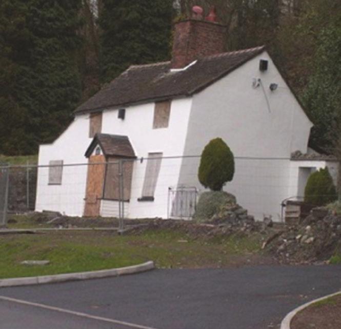
THE FEASIBILITY AND APPLICATION OF PSI TO DETECT A RANGE OF GROUND AND STRUCTURE MOTION PHENOMENA.
 THE FEASIBILITY AND APPLICATION OF PSI TO DETECT A RANGE OF GROUND AND STRUCTURE MOTION PHENOMENA. Rachel Holley, InSAR Surveying Consultant InSAR Surveying Team Fugro NPA Satellite Mapping Introduction
Trends in Human Development Index of European Union
 Trends in Human Development Index of European Union Department of Statistics, Hacettepe University, Beytepe, Ankara, Turkey spxl@hacettepe.edu.tr, deryacal@hacettepe.edu.tr Abstract: The Human Development
2010 Oracle Corporation 1
 1 Map Views in Oracle Business Intelligence Enterprise Edition, 11g Abhinav Agarwal Jayant Sharma Consulting Product Manager, OBIEE Director, Prod. Mgmt., Oracle Spatial THE FOLLOWING
EUMETSAT Satellite Programmes Use of McIDAS at EUMETSAT
 EUMETSAT Satellite Programmes Use of McIDAS at EUMETSAT Marianne König Peter Miu McIDAS Users' Group Meeting, 07-10 May 2012 Slide 1 EUMETSAT Headquarters Darmstadt McIDAS Users' Group Meeting, 07-10 May
This document is a preview generated by EVS
 TECHNICAL SPECIFICATION SPÉCIFICATION TECHNIQUE TECHNISCHE SPEZIFIKATION CEN/TS 17268 December 2018 ICS 35.240.60 English Version Intelligent transport systems - ITS spatial data - Data exchange on changes
Publication Date: 15 Jan 2015 Effective Date: 12 Jan 2015 Addendum 6 to the CRI Technical Report (Version: 2014, Update 1)
") Publication Date: 15 Jan 2015 Effective Date: 12 Jan 2015 This document updates the Technical Report (Version: 2014, Update 1) and details (1) Replacement of interest rates, (2) CRI coverage expansion,
Publication Date: 15 Jan 2015 Effective Date: 12 Jan 2015 This document updates the Technical Report (Version: 2014, Update 1) and details (1) Replacement of interest rates, (2) CRI coverage expansion,
Coastal data for Integrated Maritime Policies
 Coastal data for Integrated Maritime Policies LOCHET Corine Shom Name of presentation Protection against erosion and marine flood Name presenter Link between different data scales and Name of presentation
Regional economy upgrading triple helix at work? Some selected cases from the Czech republic (and Central Eastern Europe) Pavel Ptáček
 Pavel Ptáček") Regional economy upgrading triple helix at work? Some selected cases from the Czech republic (and Central Eastern Europe) Pavel Ptáček Department of Geography Palacký University in Olomouc, Czech republic
Regional economy upgrading triple helix at work? Some selected cases from the Czech republic (and Central Eastern Europe) Pavel Ptáček Department of Geography Palacký University in Olomouc, Czech republic
United Nations Environment Programme
 UNITED NATIONS United Nations Environment Programme Distr. GENERAL UNEP/OzL.Pro/ExCom/80/3 26 October 2017 EP ORIGINAL: ENGLISH EXECUTIVE COMMITTEE OF THE MULTILATERAL FUND FOR THE IMPLEMENTATION OF THE
Annotated Exam of Statistics 6C - Prof. M. Romanazzi
 1 Università di Venezia - Corso di Laurea Economics & Management Annotated Exam of Statistics 6C - Prof. M. Romanazzi March 17th, 2015 Full Name Matricola Total (nominal) score: 30/30 (2/30 for each question).
United Nations Environment Programme
 UNITED NATIONS United Nations Environment Programme Distr. GENERAL 13 April 2016 EP ORIGINAL: ENGLISH EXECUTIVE COMMITTEE OF THE MULTILATERAL FUND FOR THE IMPLEMENTATION OF THE MONTREAL PROTOCOL Seventy-sixth
PROSPECTIVE AREAS FOR CRITICAL RAW MATERIALS IN THE EU
 This project has received funding from the European Union s Horizon 2020 research and innovation programme under grant agreement No. 776487 Ref. Ares(2017)5879386-30/11/2017 PROSPECTIVE AREAS FOR CRITICAL
This document is a preview generated by EVS
 TECHNICAL SPECIFICATION SPÉCIFICATION TECHNIQUE TECHNISCHE SPEZIFIKATION CEN ISO/TS 15530-3 December 2007 ICS 17.040.30 English Version Geometrical product specifications (GPS) - Coordinate measuring machines
MAPPING LAND COVER OF EUROPE FOR 2006 UNDER GMES
 Proceedings of the 2 nd Workshop of the EARSeL SIG on Land Use and Land Cover MAPPING LAND COVER OF EUROPE FOR 2006 UNDER GMES Chris Steenmans 1 and George Büttner 2 1. European Environment Agency, Kongens
Variance estimation on SILC based indicators
 Variance estimation on SILC based indicators Emilio Di Meglio Eurostat emilio.di-meglio@ec.europa.eu Guillaume Osier STATEC guillaume.osier@statec.etat.lu 3rd EU-LFS/EU-SILC European User Conference 1
Part A: Salmonella prevalence estimates. (Question N EFSA-Q ) Adopted by The Task Force on 28 March 2007
 Adopted by The Task Force on 28 March 2007") The EFSA Journal (2007) 98, 1-85 Report of the Task Force on Zoonoses Data Collection on the Analysis of the baseline survey on the prevalence of Salmonella in broiler flocks of Gallus gallus, in the EU,
The EFSA Journal (2007) 98, 1-85 Report of the Task Force on Zoonoses Data Collection on the Analysis of the baseline survey on the prevalence of Salmonella in broiler flocks of Gallus gallus, in the EU,
INSPIRE Implementation in Estonia using ArcGIS
 INSPIRE Implementation in Estonia using ArcGIS Sulev Õitspuu Head of Bureau of Geoinfosystems Estonian Land Board 26.09.2016 Population: 1,3 million (69% Estonians) Area: 45,339 km 2 15 counties Estonia
Assessment and Improvement of Methodologies used for GHG Projections
 Assessment and Improvement of Methodologies used for GHG Projections Jan Duerinck Etsap workshop 3 July 2008 Paris Who is using Markal and how Jan Duerinck Etsap workshop 3 July 2008 Paris 1 Outline of
Measuring Instruments Directive (MID) MID/EN14154 Short Overview
 MID/EN14154 Short Overview") Measuring Instruments Directive (MID) MID/EN14154 Short Overview STARTING POSITION Approval vs. Type examination In the past, country specific approvals were needed to sell measuring instruments in EU
Measuring Instruments Directive (MID) MID/EN14154 Short Overview STARTING POSITION Approval vs. Type examination In the past, country specific approvals were needed to sell measuring instruments in EU
DEPENDENCE OF THE LOCATION OF THE EUROPEAN CAPITALS AND COMPETITIVENESS OF THE REGIONS
 DEPENDENCE OF THE LOCATION OF THE EUROPEAN CAPITALS AND COMPETITIVENESS OF THE REGIONS Pawel Dobrzanski Abstract Competitiveness is one of the most important topics of modern economics. Current research
STATEMENT ON EBA CAPITAL EXERCISE
 Hong Kong Exchanges and Clearing Limited and The Stock Exchange of Hong Kong Limited take no responsibility for the contents of this document, make no representation as to its accuracy or completeness
Final report for the Expert Group on the Integration of Statistical and Geospatial Information, May 2015
 Final report for the Expert Group on the Integration of Statistical and Geospatial Information, May 2015 Global geographic classification and geocoding practices Executive summary This final report was
Grant Agreement No. EIE/07/595/SI BEn
 Biomass energy register for sustainable site development for European regions Grant Agreement No. EIE/07/595/SI2.499697 BEn Biomass energy register for sustainable site development for European regions
Drawing the European map
 Welcome in Europe Objectif: mieux connaitre l'espace géographique et civilisationnel européen Opérer la distinction entre pays d'europe et pays de l'union Européenne Tâche intermédiaire: restitution de
Progress of UN-GGIM: Europe Working Group A on Core Data
 INSPIRE KEN 13 December 2016 Progress of UN-GGIM: Europe Working Group A on Core Data François Chirié, Dominique Laurent, IGN France Plan Introduction Objectives of the working group with respect to INSPIRE
Progress of UN-GGIM: Europe Working Group A on Core Data
 PolicyKEN Budapest 29 November 2016 Progress of UN-GGIM: Europe Working Group A on Core Data François Chirié, Dominique Laurent, IGNF Core data context Background and purpose Aim of Work Group A to propose
EuroGeoSource project
 3/18/2011 Stephan Gruijters, coordinator Euro Geo Source EuroGeoSource project -WP4- Harmonisation of the georesources attributes and the data exchange format Jasna Šinigoj, Duška Rokavec Geological Survey
INSPIRing effort. Peter Parslow Ordnance Survey December Various European approaches to managing an SDI
 INSPIRing effort Peter Parslow Ordnance Survey December 2015 Various European approaches to managing an SDI WHAT IS INSPIRE? A European Union Directive A community effort: http://inspire.ec.europa.eu/
An Eye in the Sky EUMETSAT. Monitoring Weather, Climate and the Environment
 An Eye in the Sky EUMETSAT Monitoring Weather, Climate and the Environment Slide: 1 Hazardous Weather Slide: 2 Hazardous Weather Slide: 3 Natural Disasters set off by severe weather Slide: 4 EUMETSAT Objectives...
This document is a preview generated by EVS
 TECHNICAL SPECIFICATION SPÉCIFICATION TECHNIQUE TECHNISCHE SPEZIFIKATION CEN ISO/TS 15883-5 November 2005 ICS 11.080.10 English Version Washer-disinfectors - Part 5: Test soils and methods for demonstrating
EuroDEM User Guide Refers to EuroDEM 1.0, released in April 2008
 EuroDEM User Guide Refers to EuroDEM 1.0, released in April 2008 Page 1 Contents INTRODUCTION... 3 CONTACT DETAILS... 3 PRODUCT PERFORMANCE... 3 LIABILITY... 3 DELIVERY OF EURODEM... 4 DATA COPYRIGHT...
E-SURFMAR Report. Jean ROLLAND Gilbert EMZIVAT Pierre BLOUCH Jon TURTON
 E-SURFMAR Report Jean ROLLAND Gilbert EMZIVAT Pierre BLOUCH Jon TURTON DBCP 30 WEIHAI 27-31 October 2014 E-SURFMAR EUMETNET members 31 European Meteorological Services. Austria, Belgium, Croatia, Cyprus,
Economic and Social Council
 United Nations Economic and Social Council Distr.: General 30 August 2012 Original: English Economic Commission for Europe Inland Transport Committee Working Party on Rail Transport Sixty-sixth session
EUMETSAT EXPERIENCES IN RESPONDING TO THE REQUIREMENTS OF OPERATIONAL USERS
 EUMETSAT EXPERIENCES IN RESPONDING TO THE REQUIREMENTS OF OPERATIONAL USERS Outlook What is EUMETSAT How does EUMETSAT work Building capacity for a better utilisation of satellite data Example working
EUMETSAT Satellite Status
 EUMETSAT Satellite Status Dr. K. Dieter Klaes EUMETSAT 1 ET-SAT Meeting 4-6 April 2017, WMO, Geneva, Switzerland EUMETSAT is an intergovernmental organisation with 30 Member States and 1 Cooperating State
Geological information for Europe : Towards a pan-european Geological Data Infrastructure
 Geological information for Europe : Towards a pan-european Geological Data Infrastructure Integrating geoscientific information for EU competitiveness Co-funded by the European Union European societal
Feasibility Study: GEOSCIENTIFIC KNOWLEDGE AND SKILLS OF AFRICAN GEOLOGICAL SURVEYS. WP 3 - Gap analysis of geoscientific mapping
 Feasibility Study: GEOSCIENTIFIC KNOWLEDGE AND SKILLS OF AFRICAN GEOLOGICAL SURVEYS WP 3 - Gap analysis of geoscientific mapping Acquisition of metadata to geological maps as base for the compilation of
Sampling scheme for LUCAS 2015 J. Gallego (JRC) A. Palmieri (DG ESTAT) H. Ramos (DG ESTAT)
 A. Palmieri (DG ESTAT) H. Ramos (DG ESTAT)") Sampling scheme for LUCAS 2015 J. Gallego (JRC) A. Palmieri (DG ESTAT) H. Ramos (DG ESTAT) Abstract The sampling design of LUCAS 2015 took into account experience from previous campaigns. While remaining
Sampling scheme for LUCAS 2015 J. Gallego (JRC) A. Palmieri (DG ESTAT) H. Ramos (DG ESTAT) Abstract The sampling design of LUCAS 2015 took into account experience from previous campaigns. While remaining