Wireless Sensor Network for Detecting Disasters
|
|
|
- Buck Davidson
- 5 years ago
- Views:
Transcription

1 AUM AMRITESWARYAI NAMAH CANEUS SSTDM 2014 Wireless Sensor Network for Detecting Disasters Dr. Maneesha Ramesh, Director & Professor Amrita Cenetr for Wireless Networks and Applications, Amrita Vishwa Vidyapeetham
2 Disasters Between 2000 and 2012, natural disasters caused $1.7 trillion in damage affected 2.9 billion people 1.1 million people were killed Worldwide in 2011, there were 154 floods, 16 droughts, and 15 cases of extreme temperature 2012 natural disaster damage exceeding $100 billion.
3 Disasters Floods the most widespread natural disaster Earthquakes: cause associated destruction of man-made structures instigate other natural disasters such as tsunamis, avalanches, and landslides Hurricanes coupled with storm surges and sever flooding Landslides often accompany earthquakes, floods, storm surges, hurricanes, wildfires, or volcanic activity often damaging and deadly than the triggering event
4 Monitoring Techniques Large Scale Monitoring (Macro) Satellite Systems Remote Sensing Mobile Vehicle Based Sensing Site Specific Monitoring (Micro) Wireless Sensor Network Mobile Computing Area of Monitoring Frequency of Monitoring Knowledge of Location Uncertanity Participatory Sensing/Monitoring Mobile Phone Participants participation
5 Disasters Vs. Parameters Disasters Landslide Flood Drought Hurricane Storms Avalanche Forest Fire Earthquake Parameters Rainfall Moisture Water Level Wind Movement Temperature Humidity Vibration
6 Requirements for Monitoring Sub Systems Sensors Data Collection Techniques Data Aggregation Techniques Real-time Communication Technology Complex Data Analysis Multiple methods for detection Alert Dissemination Required Functionalities Long Term Monitoring Network Lifetime Extension Fault Tolerant Communication Technology Heterogeneous Data Aggregation, Analysis Multi-path for Alert Dissemination
7 Major disasters instigate other multiple types of disasters
8 Ubiquitious Mult-Context Model
9 Wireless Sensor Network for Monitoring and Detection of Landslides Amrita University
")
10 Introduction 10 Environmental Disasters: Landslides are the third most deadly natural disaster on earth Wireless Sensor Networks for Real-Time Landslide Monitoring Comparison of casualties for different natural hazards (Source: CRED) 22-Apr-14

11 Introduction Environmental disasters are largely unpredictable and occur within very short spans of time. Wireless sensors are one of the cutting edge technologies that can quickly respond to Rapid changes of data, Process data, and Transmit the sensed data Limitations include relatively low amounts of battery power and low memory availability compared to many existing technologies Main advantage: Deploying sensors in hostile environments with a bare minimum of maintenance. 11 Maneesha V Ramesh, AMRITA University 4/22/2014
12 Major Outcomes 12 World s first ever comprehensive wireless sensor network for landslide detection -AMRITA wireless sensor network for landslide detection India s first ever landslide laboratory set up for landslide detection -AMRITA landslide laboratory set up for landslide detection Maneesha V Ramesh, AMRITA University 4/22/2014
13 Landslides 13 The rapid down-slope movement of soil, rock and organic materials under the influence of gravity. Short-lived and suddenly occurring phenomena Causes extraordinary landscape changes and destruction of life and property In India, Landslides mainly happen due to the heavy rainfall. Annual loss due to landslides equivalent to $400 million This study concentrates on rainfall induced landslides Maneesha V Ramesh, AMRITA University 4/22/2014


14 Landslide Risk Zones in India 14 Landslide Risk Zones in Kerala Landslide Prone Area - Munnar Maneesha V Ramesh, AMRITA University 4/22/2014

15 Landslide Site Selection 15 The first one occurred in It was a massive landslide with an estimated volume of 10 5 m 3. The scarp has a concave curvature. The second landslide occurred on 26 July It was a complex rotational slide debris flow with a volume of approximately 10 4 m 3 and was triggered by a torrential downpour. The total rainfall recorded in Munnar on 26 July 2005 was 451mm. The same downpour also triggered two other landslides in the vicinity Maneesha V Ramesh, AMRITA University 4/22/2014
16 Wireless Deep Earth Probe Geophysical sensors Wired High Maintanence 16 Wireless Sensor Networks Commercially available wireless sensor nodes do not have the geophysical sensors such as Rain gauge Moisture sensor Pore pressure sensor Strain gauge Tilt meter Geophone Geophysical sensors are interfaced with the wireless sensor node through an Interfacing circuit Data acquisition board Maneesha V Ramesh, AMRITA University 4/22/2014
 and Rain Gauge (RG) CANEUS SSTDM")
17 Locations of the Deep Earth Probes (DEPs) and Rain Gauge (RG) CANEUS SSTDM 2014
18 WSN Monitoring & Warning System 24/7 operational Landslide Monitoring & Detection WSN Deep Earth Probes (DEPs)(maximum 23 meter deep) 150 geophysical sensors deployed Pore Pressure transducers Strain gauges Tilt meters Dielectric moisture sensor Geophone Rain gauge 20 wireless sensor nodes

19 Overall System Architecture CANEUS SSTDM 2014
20 20 Warning system Real-time Data Analysis - Three Level Warning System Warning 1: Threshold level of rain gauge & dielectric moisture sensor Warning 2: Threshold level of pore pressure transducer Warning 3: Detection of movement initiation Landslide Modeling Software Landslide Laboratory Setup Maneesha V Ramesh 6/19/2009
21 21 Design of Feedback System Remote administering, the sampling rate of the geological sensors with respect to real-time climatic variations, monitor the level of battery charges, monitor the level of solar charging rate, indicate faulty wireless sensor nodes or geological sensors etc. Maneesha V Ramesh, AMRITA University 4/22/2014


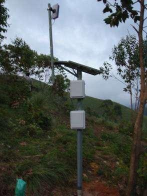
22 Current Deployment CANEUS SSTDM 2014


23 23 Maneesha V Ramesh 6/19/2009

24 24 Landslide Warning Issued 4/22/2014
25 25 Landslide Warning Issued July 21, 2009 Heavy rain fall Increase in pore pressure Slight movements Rainfall threshold exceeded with respect to Caine (1980) I 14.82D /22/2014
26 4/22/2014 Landslide laboratory set up Maneesha V Ramesh 26

27 Medium scale laboratory set up Medium Scale Laboratory Set up 2m long by 1 meter wide by 0.5 m tall and holds around 0.6 m 3 of soil Slope angle can be varied from 0 degree to 45 degree Rainfall Simulator Accurate raindrop size distribution and velocity Seepage Simulator Various infiltration rate 27 Maneesha V Ramesh 4/22/2014

28 Large scale landslide laboratory set up 4.6 m long by 2.6 m wide by 2 m tall designed to hold approximately 12 m 3 of soil. up to 24 tone's of soil can be tested, at a maximum depth of up to 4 feet Slope angle can be varied from 0 degree to 45 degree Rainfall Simulator - Accurate raindrop size distribution Seepage Simulator - Various infiltration rate 28 CANEUS SSTDM 2014 Maneesha V Ramesh 4/22/2014
29 Funding Agencies Partially funded by the WINSOC project, a Specific Targeted Research Project (Contact Number ) co-funded by the INFSO DG of the European Commission within the RTD activities of the Thematic Priority Information Society Technologies 11 partners from 8 different countries 29 Partially funded by Department of Information Technology (DIT), India with the project title as Wireless Sensor Network for Real-time Landsldie Monitoring Partially funded by Department of Science and Technology (DST), India with the project title as Monitoring and Detection of Rainfall Induced Landslide using an Integrated Wireless Network System Partially funded by Ministry of Earth Science (MoES), India with the project title as Advancing Integrated Wireless Sensor Networks for Real-time Monitoring and Detection of Disasters Maneesha V Ramesh, AMRITA University 4/22/2014
30 Publications Maneesha Vinodini Ramesh, Design, Development, and Deployment of a Wireless Sensor Network for Detection of Landslides, Ad Hoc Networks, Elsevier, 2012 Maneesha Ramesh & Nirmala Vasudevan (2011) The Deployment of Deep Earth Sensor Probes for Landslide Detection, Landslides, DOI /s x, Springer Verlag, US (In Press), 21 September 2011 Maneesha Ramesh, Real-Time Wireless Sensor Network for Landslide Detection, Third International Conference on Sensor Technologies and Applications (SENSORCOMM 2009) in Athens, Greece. (BEST PAPER AWARD)
31 Publications Continued "Wireless Geophone Network for Remote Monitoring and Detection of Landslides", by Abishek. T. K, Maneesha. V. Ramesh, ICCSP 2011, Calicut India, IEEE Xplore. A complete chapter named Wireless Sensor Networks for Disaster Management for the book titled Wireless Sensor Networks published by INTECH. "Signal Processing for Wireless Geophone Network to Detect Landslides has been accepted", Abishek T.K, Dr.Maneesha V. Ramesh &Vijayan Selvan, ICCAEI 2010, Malaysia. Integrating Geophone Network to Real-Time Wireless Sensor Network System for Landslide Detection, by Abishek T. K and Dr.Maneesha V. Ramesh. in the SENSORCOMM 2010 conference (published in IEEE Xplore) Lightweight Management Framework (LMF) for a Heterogeneous Wireless Network for Landslide Detection by Sangeeth Kumar & Dr.Maneesha V. Ramesh, at the International conference on Wireless & Mobile Networks, WiMoN 2010 (published in lecture series of Springer)
32 Publications Continued Wireless Sensor Network Localization With Imprecise Measurements Using Only a Quadratic Solver, by Maneesha V. Ramesh & K. P. Soman. Wireless Sensor Network for Landslide Detection, Maneesha V. Ramesh, Sangeeth Kumar, and P. Venkat Rangan Real Time Landslide Monitoring viawireless Sensor Network, M.V. Ramesh, N. Vasudevan, and J. Freeman Factors and Approaches towards Energy Optimized Wireless Sensor Networks to Detect Rainfall Induced Landslides, Maneesha V. Ramesh, Rehna Raj, Joshua Udar Freeman, Sangeeth Kumar, P. Venkat Rangan Fault Tolerant Clustering Approaches in Wireless Sensor Network for Landslide Are Monitoring Rehana raj T, Maneesha V Ramesh, Sangeeth Kumar Threshold Based Data Aggregation Algorithm To Detect Rainfall Induced Landslide, Maneesha V. Ramesh P. V. Ushakumari Biologically Inspired Data Propagation and Aggregation Method for Wireless Sensor Networks. J. Freeman1, M. V. Ramesh2, and A. Mohan1
33 Research Initiatives The State Government & Disaster Management Departments has requested us to expand the wireless sensor network installation to other landslide prone areas in future major regions all over India: Maharashtra State, Kerala State, the North Eastern region, and the Himalayan region
34 Drought Forecast and Alert System [2]
35 Drought Meteorological drought refers to the drought caused by abnormal climate and maladjusted rainfall. Hydrological drought indicates that there is no enough water supply for various applications due to water shortage in ground surface, such as lower water level of river or reservoir. Agricultural drought indicates that crops cannot grow normally due to insufficient soil moisture caused by water shortage within a certain period of time. Therefore, DFAS takes the rainfall and soil moisture as major variables for drought identification and monitoring covering meteorological and agricul- tural drought.
36 DFAS identification and monitoring of meteorological and agricultural drought Major Parameters and Sensors Rainfall Rainfall sensor Moisture soil moisture sensor


37 Drought forecast and alert system and network architecture
38 Real-time flood monitoring and warning system
39 Sensing Parameters The system for real-time monitoring of water conditions: water level flow precipitation level This system was developed to be employed in monitoring flood in Nakhon Si Thammarat, a southern province in Thailand
40 ongklanakarin Architecture J. Sci. Technol. 33 (2), , 2011 itting server Web Services Mobile Service (WAP) Monitoring Remote Sensors: Water level, water velocity/ Flow, and rainfall Database and Web Application Server of the sing to s. The vel in s. The mized tation. GPRS Data Unit: Data Processing and Transmission via GPRS Remote Site Mobile GPRS CommunicationTunnel TCP/IP GPRS Gateway Server: Data Processing and Transmission via GPRS Control Center CANEUS SSTDM 2014

41 Ubiquitious Mult-Context Model
42 Requirements Multi--Context System Context Aware System Location Based System Context Classification Heterogeneous Data Aggregation Adaptive Alert System
43 Monitor and Detect major disasters Monitor and Detect other multiple types of disasters instigated by the major disaster
44 References 1. tools/11-facts-about-disasters pdf 3.
45 Thank You CANEUS SSTDM 2014
APPLICATION OF REMOTE SENSING & GIS ON LANDSLIDE HAZARD ZONE IDENTIFICATION & MANAGEMENT
 APPLICATION OF REMOTE SENSING & GIS ON LANDSLIDE HAZARD ZONE IDENTIFICATION & MANAGEMENT PRESENTED BY SUPRITI PRAMANIK M.TECH IN ENVIRONMENTAL SCIENCE AND TECHNOLOGY NIT,DURGAPUR 25-04-2015 1 INTRODUCTION
Overview of Philippine Geohazards Programs
 Overview of Philippine Geohazards Programs 53 rd CCOP Annual Session CCOP-IUGS Task Group on Geohazards Joint Seminar Cebu City, PHILIPPINES October 18, 2017 Renato U. Solidum, Jr. Department of Science
Caribbean Early Warning System Workshop
 Caribbean Early Warning System Workshop Hamonization in Existing EWS April 14-16, 2016 Presenter: Shawn Boyce Caribbean Institute for Meteorology and Hydrology Husbands, St. James Barbados Background Between
Indian Ocean Tsunami Warning System: Example from the 12 th September 2007 Tsunami
 Indian Ocean Tsunami Warning System: Example from the 12 th September 2007 Tsunami Charitha Pattiaratchi 1 Professor of Coastal Oceanography, The University of Western Australia Email: chari.pattiaratchi@uwa.edu.au
Earthquake Hazards. Tsunami
 Earthquake Hazards Tsunami Measuring Earthquakes Two measurements that describe the power or strength of an earthquake are: Intensity a measure of the degree of earthquake shaking at a given locale based
Earthquake Hazards. Tsunami
 Earthquake Hazards Tsunami Review: What is an earthquake? Earthquake is the vibration (shaking) and/or displacement of the ground produced by the sudden release of energy. The point inside the Earth where
Need of Proper Development in Hilly Urban Areas to Avoid
 Need of Proper Development in Hilly Urban Areas to Avoid Landslide Hazard Dr. Arvind Phukan, P.E. Cosultant/Former Professor of Civil Engineering University of Alaska, Anchorage, USA RI District Governor
Complete Weather Intelligence for Public Safety from DTN
 Complete Weather Intelligence for Public Safety from DTN September 2017 White Paper www.dtn.com / 1.800.610.0777 From flooding to tornados to severe winter storms, the threats to public safety from weather-related
Earthquake Hazards. Tsunami
 Earthquake Hazards Tsunami Review: What is an earthquake? Earthquake is the vibration (shaking) and/or displacement of the ground produced by the sudden release of energy. The point inside the Earth where
United States Multi-Hazard Early Warning System
 United States Multi-Hazard Early Warning System Saving Lives Through Partnership Lynn Maximuk National Weather Service Director, Central Region Kansas City, Missouri America s s Weather Enterprise: Protecting
What Are Disasters? The Rescue Kids Trio!
 The Rescue Kids Trio! What Are Disasters? This manual was made possible through funding by the Council of Local Authorities for International Relations. Disasters and emergency preparedness Emergency preparedness
Initiative. Country Risk Profile: papua new guinea. Better Risk Information for Smarter Investments PAPUA NEW GUINEA.
 Pacific Catastrophe Risk Assessment And Financing Initiative PAPUA NEW GUINEA September 211 Country Risk Profile: papua new is expected to incur, on average, 85 million USD per year in losses due to earthquakes
2018 REVIEW OF DISASTER EVENTS
 2018 REVIEW OF DISASTER EVENTS Supplementary Information* BRUSSELS, 24 January, 2019 In 2018, there were 281 climate-related and geophysical events recorded in the EM-DAT (International Disaster Database)
CLIMATE CHANGE ADAPTATION BY MEANS OF PUBLIC PRIVATE PARTNERSHIP TO ESTABLISH EARLY WARNING SYSTEM
 CLIMATE CHANGE ADAPTATION BY MEANS OF PUBLIC PRIVATE PARTNERSHIP TO ESTABLISH EARLY WARNING SYSTEM By: Dr Mamadou Lamine BAH, National Director Direction Nationale de la Meteorologie (DNM), Guinea President,
WMO Statement on the State of the Global Climate Preliminary conclusions for 2018 and WMO Greenhouse Bulletin
 WMO Statement on the State of the Global Climate Preliminary conclusions for 2018 and WMO Greenhouse Bulletin Dr Elena Manaenkova Deputy Secretary General World Meteorological Organisation Statement on
Sensors and Small Satellite Technologies for Disaster Management (SSTDM) 2016
 2016") 2016 Sensors and Small Satellite Technologies for Disaster Management (SSTDM) 2016 Opportunities for Global and Indo-US Collaboration: Seeking Guidance @ UN/ India Workshop, Hyderabad, India 10 March,
2016 Sensors and Small Satellite Technologies for Disaster Management (SSTDM) 2016 Opportunities for Global and Indo-US Collaboration: Seeking Guidance @ UN/ India Workshop, Hyderabad, India 10 March,
WMO/WWRP FDP: INCA CE
 WMO/WWRP FDP: INCA CE Yong Wang ZAMG, Austria This project is implemented through the CENTRAL EUROPE Programme co-financed by the ERDF INCA CE: implementation over Central Europe A Nowcasting Initiative
HISTORY OF HEAVY RAINFALL DISASTER INFORMATION IN JAPAN
 transmission, for a state-of-the-art review. In addition, issues expected to arise in the future are discussed. HISTORY OF HEAVY RAINFALL DISASTER INFORMATION IN JAPAN Progress of Rainfall Observation
WEATHER AND CLIMATE EXTREMES MONITORING BASED ON SATELLITE OBSERVATION : INDONESIA PERSPECTIVE RIRIS ADRIYANTO
 WEATHER AND CLIMATE EXTREMES MONITORING BASED ON SATELLITE OBSERVATION : INDONESIA PERSPECTIVE RIRIS ADRIYANTO INDONESIA AGENCY FOR METEOROLOGY, CLIMATOLOGY AND GEOPHYSICS (BM KG) 1. INTRODUCTION - BMKG
Formulation of the Strategy for Disaster Risk Reduction and Emergency Preparedness and Response of the Asia-Pacific Region
 2008/SOM3/TFEP/SEM/006 Formulation of the Strategy for Disaster Risk Reduction and Emergency Preparedness and Response of the Asia-Pacific Region 2009-2015 Submitted by: Thailand Emergency Management CEOs
2014 Summer training course for slope land disaster reduction Taipei, Taiwan, Aug
 MINISTRY OF SCIENCE AND TECHNOLOGY HYDROTECH RESEARCH INSTITUTE MINISTRY OF NATURAL RESOURCES AND ENVIRONMENT VIETNAM INSTITUTE OF GEOSCIENCES AND MINERAL RESOURCES (VIGMR) 2014 Summer training course
Theme 4. Disaster Mitigation and Risk Management
 Theme 4 Disaster Mitigation and Risk Management World Flood Map in 2002 Released by WMO as of August 29 Over 17 million were affected (in more than 80 countries) 3,000 were killed Total damage of over
THE INTEGRATED INFORMATION SYSTEM FOR NATURAL
 THE INTEGRATED INFORMATION SYSTEM FOR NATURAL DISASTER MITIGATION Junxiu Wu 1, Qiang Feng 2*, Bijun Liang 3, and Angsheng Wang 4 1 Department of Computer System, Technological Bureau of Xinhua News Agency,
Natural Disasters in Member Countries (2002 Summary)
") 4.2 Member Countries and their Disaster Characteristics: Table 5: Natural Disasters in Member Countries (2002 Summary) (Country/Disaster Type/Disaster Characteristics) Data Country DisType Count of TotAff
4.2 Member Countries and their Disaster Characteristics: Table 5: Natural Disasters in Member Countries (2002 Summary) (Country/Disaster Type/Disaster Characteristics) Data Country DisType Count of TotAff
Preparing Landslide Inventory Maps using Virtual Globes
 Introduction: A landslide is the movement of a mass of rock, debris, or earth down a slope, under the influence of gravity. Landslides can be caused by different phenomena, including intense or prolonged
Assessing Hazards and Risk
 Page 1 of 6 EENS 204 Tulane University Natural Disasters Prof. Stephen A. Nelson Assessing Hazards and Risk This page last updated on 07-Jan-2004 As discussed before, natural disasters are produced by
July 5-6, 2010 Mytilene, Greece
 Web GIS platform for forest fire management Prof. Kostas Kalabokidis Principal Investigator Univ. of the Aegean, Dept. of Geography, Greece Prof. George Kallos Univ. of Athens, Dept. of Physics, Greece
Correcting Real Time Automatic Weather Stations Data Through Quality Checks and Analysis
 Correcting Real Time Automatic Weather Stations Data Through Quality Checks and Analysis Sd. Thouseef Ahmed Shoaib and Syed Nayab Rasool Andhra Pradesh State Development Planning Society, Hyderabad Email:
GEO The Åknes rock slope. Content. Dr. Vidar Kveldsvik NGI
 GEO 4180 The Åknes rock slope Dr. Vidar Kveldsvik NGI Content Background on large rock slides Triggers Stability analysis Risk mitigation (risk reduction) The Åknes rock slope 1 Background Landslides due
Haiti and Dominican Republic Flash Flood Initial Planning Meeting
 Dr Rochelle Graham Climate Scientist Haiti and Dominican Republic Flash Flood Initial Planning Meeting September 7 th to 9 th, 2016 Hydrologic Research Center http://www.hrcwater.org Haiti and Dominican
Regional EGM on Community of Practice of Georeferenced Information System. for Disaster Risk Management (Geo-DRM) April 2014, Bangkok, Thailand
 April 2014, Bangkok, Thailand") Regional EGM on Community of Practice of Georeferenced Information System for Disaster Risk Management (Geo-DRM) 23-25 April 2014, Bangkok, Thailand Presented By Mukesh Kumar Keshari Ministry of Home Affairs
Regional EGM on Community of Practice of Georeferenced Information System for Disaster Risk Management (Geo-DRM) 23-25 April 2014, Bangkok, Thailand Presented By Mukesh Kumar Keshari Ministry of Home Affairs
A Data Fusion Approach to Real-time Monitoring Systems and Information Management
 Landslide Preparedness in the ASEAN Member States A Data Fusion Approach to Real-time Monitoring Systems and Information Management Jessada Karnjana, PhD National Electronics and Computer Technology Center
Disclaimer. This report was compiled by an ADRC visiting researcher (VR) from ADRC member countries.
 from ADRC member countries.") Disclaimer This report was compiled by an ADRC visiting researcher (VR) from ADRC member countries. The views expressed in the report do not necessarily reflect the views of the ADRC. The boundaries and
Disclaimer This report was compiled by an ADRC visiting researcher (VR) from ADRC member countries. The views expressed in the report do not necessarily reflect the views of the ADRC. The boundaries and
9/23/2013. Introduction CHAPTER 7 SLOPE PROCESSES, LANDSLIDES, AND SUBSIDENCE. Case History: La Conchita Landslide
 Introduction CHAPTER 7 SLOPE PROCESSES, LANDSLIDES, AND SUBSIDENCE Landslide and other ground failures posting substantial damage and loss of life In U.S., average 25 50 deaths; damage more than $3.5 billion
Early Warning System and Role of IMD. Manmohan Singh Meteorological Centre Shimla
 Early Warning System and Role of IMD Manmohan Singh Meteorological Centre Shimla India a land with a unique climatic regime Two monsoon seasons (southwest & northeast monsoons) Two cyclone seasons (pre
National Public Weather and Warning Services in the Swaziland Meteorological Service Dennis S.Mkhonta /
 National Public Weather and Warning Services in the Swaziland Meteorological Service Dennis S.Mkhonta dennis.mkhonta@gmail.com / dennis@swazimet.gov.sz Introduction Swaziland s geographical position exposes
Sri Lanka Enhancing the Role of ICTs for Disaster Risk Management
 Workshop on ICT for Promoting Inclusive and Disaster Resilient Development Ulaanbaatar, Mongolia Sri Lanka Enhancing the Role of ICTs for Disaster Risk Management Kanchana Thudugala Programme Head, eservices
INCA CE: Integrating Nowcasting with crisis management and risk prevention in a transnational framework
 INCA CE: Integrating Nowcasting with crisis management and risk prevention in a transnational framework Yong Wang ZAMG, Austria This project is implemented through the CENTRAL EUROPE Programme co-financed
Report on Disaster statistics of Nepal
 Report on Disaster statistics of Nepal Submitted by Altaf Rehman Submitted to Dr. Naveed Ahmed University of engineering and technology Peshawar Assignment 1 Section A Registration id 14PWCIV456 Page 1
Flash Flood Guidance System On-going Enhancements
 Flash Flood Guidance System On-going Enhancements Hydrologic Research Center, USA Technical Developer SAOFFG Steering Committee Meeting 1 10-12 July 2017 Jakarta, INDONESIA Theresa M. Modrick Hansen, PhD
Debris flow: categories, characteristics, hazard assessment, mitigation measures. Hariklia D. SKILODIMOU, George D. BATHRELLOS
 Debris flow: categories, characteristics, hazard assessment, mitigation measures Hariklia D. SKILODIMOU, George D. BATHRELLOS Natural hazards: physical phenomena, active in geological time capable of producing
Landslide monitoring system in Iceland. Harpa Grímsdóttir Jón Kristinn Helgason NVE, Oslo, October
 Landslide monitoring system in Iceland Harpa Grímsdóttir Jón Kristinn Helgason NVE, Oslo, October 26 2016 History Avalanches and landslides have caused extensive damages and loss of human lives in Iceland
1 Introduction. Station Type No. Synoptic/GTS 17 Principal 172 Ordinary 546 Precipitation
 Use of Automatic Weather Stations in Ethiopia Dula Shanko National Meteorological Agency(NMA), Addis Ababa, Ethiopia Phone: +251116639662, Mob +251911208024 Fax +251116625292, Email: Du_shanko@yahoo.com
Regional Flash Flood Guidance and Early Warning System
 WMO Training for Trainers Workshop on Integrated approach to flash flood and flood risk management 24-28 October 2010 Kathmandu, Nepal Regional Flash Flood Guidance and Early Warning System Dr. W. E. Grabs
Emerging Needs, Challenges and Response Strategy
 Emerging Needs, Challenges and Response Strategy Development of Integrated Observing Systems in China JIAO Meiyan Deputy Administrator China Meteorological Administration September 2011 Geneva Outline
EIT-Japan Symposium 2011 on Human Security Engineering
 EIT-Japan Symposium 2011 on Human Security Engineering 2011 Disastrous Landslides at Khao Panom, Krabi, Thailand Suttisak Soralump Geotechnical Engineering Research and Development Center (GERD) Faculty
They include earthquakes, volcanic eruptions, floods, landslides, and other processes and occurrences. They are included in the broader concept of.
 They include earthquakes, volcanic eruptions, floods, landslides, and other processes and occurrences. They are included in the broader concept of. In general, natural processes are labeled hazardous only
Landslide Forecasting and Warning Mechanism
 Annual Conference of Relief Commissioners, Disaster Management 18 May 2018, Vigyan Bhawan, New Delhi Landslide Forecasting and Warning Mechanism Dr. Saibal Ghosh Director, GSI, New Delhi Understanding
Mass Wasting: The Work of Gravity
 Chapter 15 Lecture Earth: An Introduction to Physical Geology Twelfth Edition Mass Wasting: The Work of Gravity Tarbuck and Lutgens Chapter 15 Mass Wasting The Importance of Mass Wasting Slopes are the
Catastrophic Events Impact on Ecosystems
 Catastrophic Events Impact on Ecosystems Hurricanes Hurricanes An intense, rotating oceanic weather system with sustained winds of at least 74 mph and a welldefined eye Conditions for formation: Warm water
Improvement of Hazard Assessment and Management in the Philippines
 Improvement of Hazard Assessment and Management in the Philippines (2014 Summer Training Course for Slope Land Disaster Reduction) Ian Alejandrino (Philippines) Nguyen Manh Hieu (Vietnam) Presentation
Pacific Catastrophe Risk Assessment And Financing Initiative
 Pacific Catastrophe Risk Assessment And Financing Initiative PALAU September is expected to incur, on average,.7 million USD per year in losses due to earthquakes and tropical cyclones. In the next 5 years,
LAND DEGRADATION IN THE CARIBBEAN: QUATERNARY GEOLOGICAL PROCESSES. RAFI AHMAD
 EXTENDED TASK FORCE MEETING OF PARTICIPATING AGENCIES AND LATIN AMERICAN COUNTRIES FOR ENHANCING SOUTH-SOUTH COOPERATION BETWEEN LAC-CARIBBEAN SIDS PARTNERSHIP INITIATIVE ON LAND DEGRADATION AND SUSTAINABLE
JICA s Experiences of Connecting Japanese Science & Technologies for Disaster Risk Reduction in Developing Countries
 JICA s Experiences of Connecting Japanese Science & Technologies for Disaster Risk Reduction in Developing Countries Junji WAKUI Deputy Director General, Group Leader Disaster Risk Reduction Group Global
GENERAL. CHAPTER 1 BACKGROUND AND PURPOSE OF THE GUIDELINES Background of the Guidelines Purpose of the Guidelines...
 GENERAL CHAPTER 1 BACKGROUND AND PURPOSE OF THE GUIDELINES... 1 1.1 Background of the Guidelines... 1 1.2 Purpose of the Guidelines... 3 CHAPTER 2 APPLICATION OF THE GUIDELINES... 3 2.1 Potential Users
Crisis Management and Natural Disasters Overview of JRC operational or pre-operational activities A. Annunziato, D. Al-Khudhairy
 Papagayo, Costarica 3-4 November 2009 Security Science and The Americas 1 Joint Research Centre (JRC) Crisis Management and Natural Disasters Overview of JRC operational or pre-operational activities A.
Report. Developing a course component on disaster management
 Report Developing a course component on disaster management By Chira Prangkio Tawee Chaipimonplin Department of Geography, Faculty of Social Sciences, Chiang Mai University Thailand Presented at Indian
THE STUDY ON 4S TECHNOLOGY IN THE COMMAND OF EARTHQUAKE DISASTER EMERGENCY 1
 THE STUDY ON 4S TECHNOLOGY IN THE COMMAND OF EARTHQUAKE DISASTER EMERGENCY 1 Zhou Wensheng 1, Huang Jianxi 2, Li Qiang 3, Liu Ze 3 1 Associate Professor, School of Architecture, Tsinghua University, Beijing.
Low Cost Weather Stations for Developing Countries (Kenya)
") Low Cost Weather Stations for Developing Countries (Kenya) Charles Mwangi Kenya Space Agency 7 th UNSPIDER Conference 23th-25th October 2017 Prepared with support of: Martin Steinson/Paul Kucera - UCAR/NCAR
Low Cost Weather Stations for Developing Countries (Kenya) Charles Mwangi Kenya Space Agency 7 th UNSPIDER Conference 23th-25th October 2017 Prepared with support of: Martin Steinson/Paul Kucera - UCAR/NCAR
Earthquakes. Earthquakes and Plate Tectonics. Earthquakes and Plate Tectonics. Chapter 6 Modern Earth Science. Modern Earth Science. Section 6.
 Earthquakes Chapter 6 Modern Earth Science Earthquakes and Plate Tectonics Section 6.1 Modern Earth Science Earthquakes and Plate Tectonics Earthquakes are the result of stresses in Earth s s lithosphere.
World Meteorological Organization
 World Meteorological Organization Opportunities and Challenges for Development of Weather-based Insurance and Derivatives Markets in Developing Countries By Maryam Golnaraghi, Ph.D. Head of WMO Disaster
Overview of Early Warning Systems and the role of National Meteorological and Hydrological Services
 Overview of Early Warning Systems and the role of National Meteorological and Hydrological Services South Africa Second Experts Symposium on Multi-Hazard Early Warning Systems With focus on the Role of
The PREVIEW project: general objectives and an overview of the landslides platform
 The PREVIEW project: general objectives and an overview of the landslides platform Risk Mitigation for Earthquakes and Landslides Giacomo Falorni Earth Sciences Dept. University of Firenze 19-20 July 2007
Innovative Ways to Monitor Land Displacement
 ARTICLE Innovative Ways to Monitor Land Displacement When people think about landslides, they usually imagine large mud streams which cause considerable loss of life. Whereas such large-scale disasters
Processes and Impact of Natural Hazards
 The Big Island of Hawaii is the largest of the Hawaiian Islands. It is also home to a very active volcano. The Kilauea volcano has been active since 1983. The lava that flows from the Kilauea volcano has
Unit 4. This unit will enable you to improve coordination and communication with State and local agencies when hazardous weather threatens.
 Unit 4 This unit will enable you to improve coordination and communication with State and local agencies when hazardous weather threatens. In this unit we will discuss the role of Emergency Managers in
ENVIRONMENTAL GEOSCIENCE UNIFORM SYLLABUS
 ENVIRONMENTAL GEOSCIENCE UNIFORM SYLLABUS The Association of Professional Engineers and Geoscientists of the Province of British Columbia Note: 1. This Syllabus May Be Subject To Change 2. These Courses
CLIMATE CHANGE ASSESSMENT. A. Climate Change Risk Assessment and Adaptation Measures
 Solar Transmission Sector Project (RRP IND 49214) CLIMATE CHANGE ASSESSMENT I. Transmission System at Bhadla, Rajasthan A. Climate Change Risk Assessment and Adaptation Measures High temperature Risk is
Use of Geospatial data for disaster managements
 Use of Geospatial data for disaster managements Source: http://alertsystemsgroup.com Instructor : Professor Dr. Yuji Murayama Teaching Assistant : Manjula Ranagalage What is GIS? A powerful set of tools
OIKOS > landslide > mechanism >predisposing causes
 predisposing causes and trigger OIKOS > landslide > mechanism >predisposing causes Landslides are events that occur in space and time. As such, it is usually possible to identify both one or more landslide
NORTH VISTA SECONDARY SCHOOL HUMANITIES DEPARTMENT SECONDARY 3 EXPRESS HUMANITIES (GEOGRAPHY) 2272/02 CONTENT OUTLINE Term 1
 2272/02 CONTENT OUTLINE Term 1") NORTH VISTA SECONDARY SCHOOL HUMANITIES DEPARTMENT SECONDARY 3 EXPRESS HUMANITIES (GEOGRAPHY) 2272/02 CONTENT OUTLINE 2019 Term 1 Week Learning Outcomes Skills to be covered Assignment Test Project 1-2
NORTH VISTA SECONDARY SCHOOL HUMANITIES DEPARTMENT SECONDARY 3 EXPRESS HUMANITIES (GEOGRAPHY) 2272/02 CONTENT OUTLINE 2019 Term 1 Week Learning Outcomes Skills to be covered Assignment Test Project 1-2
12/05/2016. The First step in Adaptation to future climate change Reduce Vulnerability and Exposure to present Climate Variability (IPCC 2014)
") Integrating CCA, DRR and L+D to Address Emerging Challenges due to Slow Onset Processes Joy Jacqueline Pereira (Project Leader), SEADPRI-Universiti Kebangsaan Malaysia, Nguyen Van Thang (Collaborator),
Integrating CCA, DRR and L+D to Address Emerging Challenges due to Slow Onset Processes Joy Jacqueline Pereira (Project Leader), SEADPRI-Universiti Kebangsaan Malaysia, Nguyen Van Thang (Collaborator),
Hurricanes. Cause: a low pressure storm system over warm ocean water. Effect: potential massive widespread destruction and flooding.
 Hurricanes Hurricanes Cause: a low pressure storm system over warm ocean water. Effect: potential massive widespread destruction and flooding. Hurricanes also known as: cyclone (Indian Ocean) or typhoon
2/25/2013. Volcanoes: summary in haiku form A volcano forms. Magma comes to the surface - explodes, if felsic.
 Introduction to Environmental Geology, 5e Edward A. Keller Chapter 8 Volcanic Activity Volcanoes: summary in haiku form A volcano forms. Magma comes to the surface - explodes, if felsic. Lecture Presentation
DEBRIS FLOW MONITORING AND WARNING SYSTEMS: A NEW STUDY SITE IN THE ALPS
 DEBRIS FLOW MONITORING AND WARNING SYSTEMS: A NEW STUDY SITE IN THE ALPS Comiti F 1, Macconi P 2, Marchi L 3, Arattano M 4, Borga M 5, Brardinoni F 6, Cavalli M 3, D Agostino V 5, Hellweger S 3, Trevisani
SEISMIC RISK ASSESSMENT IN ARMENIA
 SEISMIC RISK ASSESSMENT IN ARMENIA Hovhannes Khangeldyan Head of National Crisis Management Center Rescue Service Ministry of Emergency Situations of the Republic of Armenia Tokyo, 2016 ARMENIA: GEOGRAPHICAL
Integrating Nowcastingwith crisis management and risk prevention in a transnational framework (INCA-CE)
") Integrating Nowcastingwith crisis management and risk prevention in a transnational framework (INCA-CE) Yong Wang ZAMG, Austria This project is implemented through the CENTRAL EUROPE Programme co-financed
Integrating Nowcastingwith crisis management and risk prevention in a transnational framework (INCA-CE) Yong Wang ZAMG, Austria This project is implemented through the CENTRAL EUROPE Programme co-financed
9/13/2011 CHAPTER 9 AND SUBSIDENCE. Case History: La Conchita Landslide. Introduction
 CHAPTER 9 SLOPE PROCESSES, LANDSLIDES, AND SUBSIDENCE Case History: La Conchita Landslide La Conchita: small coastal community 80 km (50 mi) northwest of Los Angeles Landslide occurred on January 10, 2005
Erupted and killed approximately 15,000 people 200 years ago
 1 2 3 4 5 6 7 8 Introduction to Environmental Geology, 5e Chapter 8 Volcanic Activity Volcanoes: summary in haiku form A volcano forms. Magma comes to the surface - explodes, if felsic. Case History: Mt.
Country Report Nepal Geospatial Data Sharing Initiatives of Survey Department Supporting Disaster Management
 Third JPTM Step 2 for Sentinel Asia 6-8 July, 2010 Manila, The Philippines Country Report Nepal Geospatial Data Sharing Initiatives of Survey Department Supporting Disaster Management Durgendra M Kayastha
Interpretive Map Series 24
 Oregon Department of Geology and Mineral Industries Interpretive Map Series 24 Geologic Hazards, and Hazard Maps, and Future Damage Estimates for Six Counties in the Mid/Southern Willamette Valley Including
SLOPE PROCESSES, LANDSLIDES, AND SUBSIDENCE
 CHAPTER 9 SLOPE PROCESSES, LANDSLIDES, AND SUBSIDENCE La Conchita slide January 10, 2005 Triggered by heavy rainfall, reactivation along an older landslide surface (35,000 years ago, 6000 years ago, and
Agency Vision and Decision- Maker Needs: A USGS Perspective
 Agency Vision and Decision- Maker Needs: A USGS Perspective Connecting Grassroots to Government for Disaster Management David Applegate USGS Associate Director for Natural Hazards September 13, 2012 U.S.
Flood Management in Japan
 Flood Management in Japan 1. Comprehensive Flood Control Measures 2. Provision of River information 3. Responses to the Niigata Torrential Rain Disaster 4. About ICHARM 5. Responses to 2011 Thailand Floods
INDONESIA IMPACT BASED FORECAST PROGRAM
 INDONESIA IMPACT BASED FORECAST PROGRAM Seoul, 19-21 November 2018 The 2nd Regional Workshop on Impact-based Forecasts in Asia Indonesia Agency for Meteorology Climatology and Geophysics (BMKG) A. Fachri
Smart use of Geographic Information System (GIS) platform for delivering weather information and nowcasting services
 platform for delivering weather information and nowcasting services") Smart use of Geographic Information System (GIS) platform for delivering weather information and nowcasting services C. K. Pan Hong Kong Observatory Hong Kong, China It is a world of beauty Source: Image
Smart use of Geographic Information System (GIS) platform for delivering weather information and nowcasting services C. K. Pan Hong Kong Observatory Hong Kong, China It is a world of beauty Source: Image
LECTURE #11: Volcanoes: Monitoring & Mitigation
 GEOL 0820 Ramsey Natural Disasters Spring, 2018 LECTURE #11: Volcanoes: Monitoring & Mitigation Date: 15 February 2018 I. What is volcanic monitoring? the continuous collection of one or more data sources
Meteorological alert system in NMS of Mongolia
 Meteorological alert system in NMS of Mongolia L.Oyunjargal, NAMEM Regional Workshop on Impact-based Forecasts in Asia Seoul, Korea, 07-09 NOV 2017 Weather related disasters 1. Strong wind and snow and
South Asia Flash Flood Guidance System Operational Workshop (Step-4)
") South Asia Flash Flood Guidance System Operational Workshop (Step-4) (5 th to 7 th June 2018) Operational Flash Flood Forecasting and Early Warnings Capabilities in Bhutan (Sonam Tashi) Weather Forecaster
South Asia Flash Flood Guidance System Operational Workshop (Step-4) (5 th to 7 th June 2018) Operational Flash Flood Forecasting and Early Warnings Capabilities in Bhutan (Sonam Tashi) Weather Forecaster
US/Global Natural Catastrophe Update
 US/Global Natural Catastrophe Update NAIC's CIPR Symposium on Implications of Increasing Catastrophe Volatility on Insurers Carl Hedde, SVP, Head of Risk Accumulation Munich Reinsurance America, Inc. Source:
Copernicus Overview. Major Emergency Management Conference Athlone 2017
 Copernicus Overview Major Emergency Management Conference Athlone 2017 Copernicus is a European programme implemented by the European Commission. The services address six thematic areas: land, marine,
Coastal Inundation Forecasting Demonstration Project CIFDP. Flood Forecasting Initiative-Advisory Group (FFI-AG 3), Geneva, 5-7 Dec, 2017
, Geneva, 5-7 Dec, 2017") Coastal Inundation Forecasting Demonstration Project CIFDP Flood Forecasting Initiative-Advisory Group (FFI-AG 3), Geneva, 5-7 Dec, 2017 Coastal Flooding & Vulnerable Populations Coastal populations are
Coastal Inundation Forecasting Demonstration Project CIFDP Flood Forecasting Initiative-Advisory Group (FFI-AG 3), Geneva, 5-7 Dec, 2017 Coastal Flooding & Vulnerable Populations Coastal populations are
Pacific Catastrophe Risk Assessment And Financing Initiative
 Pacific Catastrophe Risk Assessment And Financing Initiative VANUATU September 211 Country Risk Profile: VANUATU is expected to incur, on average, 48 million USD per year in losses due to earthquakes and
Beyond the Book. FOCUS Book
 FOCUS Book Suppose your city wants to build a new housing development on a steep slope outside town. Design a model to test whether the land is safe from the types of landslides you read about in this
Programs of Regione Campania for reduction of seismic risk (and others)
") Programs of Regione Campania for reduction of seismic risk (and others) 2011-10151015 Prof ing Edoardo Cosenza Assessore (Regional Ministry) Public Works and Civil Protection Regione Campania Napoli, 1900.
Programs of Regione Campania for reduction of seismic risk (and others) 2011-10151015 Prof ing Edoardo Cosenza Assessore (Regional Ministry) Public Works and Civil Protection Regione Campania Napoli, 1900.
Southern California Edison Wildfire Mitigation & Grid Resiliency
 Southern California Edison Wildfire Mitigation & Grid Resiliency California State Legislative Conference Committee on Wildfire Preparedness and Response August 7, 2018 CALIFORNIA S WILDFIRE RISK Year-Round
Norwegian spatial data infrastructure supporting disaster risk management Norwegian Mapping Authority
 Norwegian spatial data infrastructure supporting disaster risk management Norwegian Mapping Authority Arvid Lillethun, Norwegian Mapping Authority Land and Poverty 2018 Conference, World Bank 19.-23. March
MODELLING FROST RISK IN APPLE TREE, IRAN. Mohammad Rahimi
 WMO Regional Seminar on strategic Capacity Development of National Meteorological and Hydrological Services in RA II (Opportunity and Challenges in 21th century) Tashkent, Uzbekistan, 3-4 December 2008
Using Weather and Climate Information for Landslide Prevention and Mitigation
 Using Weather and Climate Information for Landslide Prevention and Mitigation Professor Roy C. Sidle Disaster Prevention Research Institute Kyoto University, Japan International Workshop on Climate and
2013 Esri Europe, Middle East and Africa User Conference October 23-25, 2013 Munich, Germany
 2013 Esri Europe, Middle East and Africa User Conference October 23-25, 2013 Munich, Germany Environmental and Disaster Management System in the Valles Altos Region in Carabobo / NW-Venezuela Prof.Dr.habil.Barbara