BUREAU OF MINERAL RESOURCES GEOLOGY AND GEOPHYSICS.
|
|
|
- Noah Atkins
- 5 years ago
- Views:
Transcription
1 COMMONWEALTH OF AUSTRALIA. DEPARTMENT OF NATIONAL DEVELOPMENT. BUREAU OF MINERAL RESOURCES GEOLOGY AND GEOPHYSICS. RECORDS: 1962/33 GEOLOGY OF THE B.W. IRON CLAIM, HUNDRED OF WATERHOUSE, NORTHERN TERRITORY. by P.G. Dunn The information contained in this report has been obtained by the Department of National Development, as part of the policy of the Commonwealth Government, to assist in the exploration and development of mineral resources. It may not be published in any form or used in a company prospectus without the permission in writing of the Director, Bureau of - Mineral Resources, Geology and Geophysics.
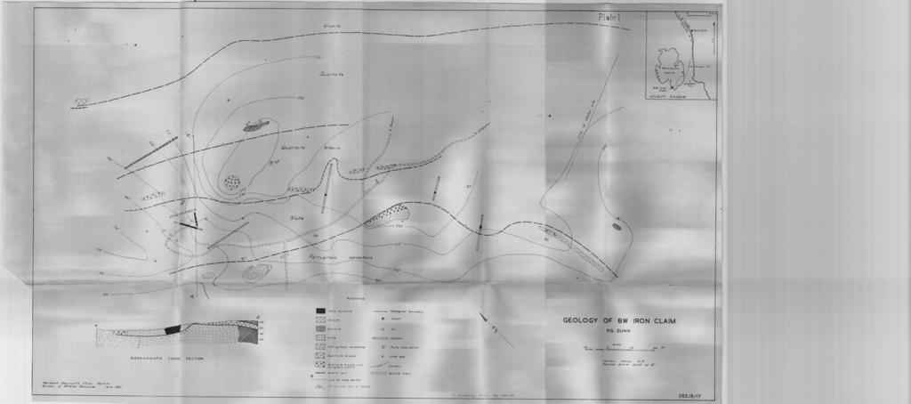
2 GEOLOGY OF THE B.W. IRON CLAIM, HUNDRED OF WATERHOUSE NORTHERN TERRITORY by P.G. Dunn RECORDS 1962/33 'CONTENTS SUMMARY^ 1 ' INTRODUCTION,^1 EXISTING EXPLORATION WORK ^ 2 GENERAL GEOLOGY^ 2 Lithology^ 2 Structure^ 3 IRON DEPOSITS^ 4 FURTHER EXPLORATION^ 5 Figure 1 - Minor fold in quartzite breccia. Matrix is hematite. Plate 1 - Geology of B.W. Iron Claim The information contained in this report has. been Obtained by the Department of National Development, as part of the policy of the Commonwealth Government, to assist in the exploration and development of mineral resources. ^It may not be published in any form or used in a company prospectus without the permission in writing of the Director, Bureau of Mineral Resources, Geology and Geophysics.
3 GEOLOGY OF THE B.W. IRON CLAIM HUNDRED OF WATERHOUSE NORTHERN TERRITORY by P.G. Dunn RECORDS 1962/33 SUMMARY The B.W. Iron Claim lies in Sections 7 and 8 of the Hundred of Waterhouse, about 17 miles southwest of Batchelor. The area includes granite and a sequence of sedimentary rocks that strike northwest and are vertical or dip steeply to the south.^they are overlain by a band of quartzite breccia. Costeans and pits have exposed several-thin bands of hematite and one large lens approximately 65 feet wide and 120 feet long. A shaft sunk in this lens exposed solid hematite to a depth of 21 feet, whete the lens is cut off by a flat-dipping fault. No ore reserves are proved although the large lens may contain as much as 15,000 tons of hematite.^further exploration should include deepening of the shaft, drilling beneath the quartzite breccia, and costeaning some of the rubble-covered slopes to test for new hematite lenses. INTRODUCTION The B.W. Iron Claim is situated in sections 7 and 8 of the Hundred of Waterhouse, and is held by Mr. B.D. Brown, on behalf of the Anglo Pacific Trading Company (New Guinea) Limited.^It can be reached by following an all-weather road from Batchelor to Banyan Homestead, and a bush track from there to the deposit.^it is approximately seven miles from Batchelor to Banyan and'a furthe r ten miles to the deposit. A four-wheel drive vehicle would be able to reach the deposit during part of the wet season.^the deposit is accessible to conventional vehicles during the dry season. - Several Visits were made to the deposit between February and June, 1961.^The present report is based on a plane table and alidade survey of an area of 2,000 feet by 1,000 feet around ' the deposit, carried out in May of this year.
4 'V 2. EXISTING EXPLORATION WORK A large amount of hematite rubble and a single outcrop of hematite first indicated the presence of a possible ore body. Samples taken by Mr. Brown from the outcrop showed that the hematite was sufficiently free from silica and other impurities for use as iron ore. The first exploratory work was the digging of a costean along the hematite outcrop and some shallow pits to determine the areal extent of the deposit. ^Later costeaning with a bulldozer was done at random over a larger area, three pits were dug to a depth of about ten feet, and a shaft was sunk on the site of the original hematite outcrop to a depth of 23 feet. Lithology GENERAL GEOLOGY The claim is in a sequence of sedimentary and metasedimentary rocks close to the southern contact of the Waterhouse Granite.^Farthest away from the granite is a red, ferruginous sandstone that forms a ridge between the Little Finniss River and the Waterhouse Granite. ^The sandstone consists mostly of quartz grains in a hematite matrix ; but along its northern edge a breccia consisting of quartz fragments in a hematite matrix crops out in places. A zone of iron-rich slates is in contact with the ferruginous sandstone, and lies between it and the granite. This Slate contains varying amounts of specular hematite, including some bands and lenses of nearly pure hematite. Most of these bands or lenses are only a few inches thick, but some are much larger; the largest so far found in this area is approximately 65 feet thick. ^One of the costeans also exposed a band of magnesite about four feet thick which is apparently conformable with the slate and is associated with a band of hematite. Several outcrops of quartz or quartzite breccia lie north of the slates.^the breccia is made up of poorly sorted angular fragments of quartz sandstone or quartzite in a quartz matrix Or, less commonly, a hematite matrix.^the largest fragments are several inches across. ^The breccia forms a low' hill above the largest hematite lens. Between the quartzite breccia and the granite there is a band of flaggy quartzite or quartz sandstone which consists of fine-,to medium-grained rounded quartz grains in a siliceous matrix.^it also includes some thin bands of quartz-rich slate. This quartzite does not make any prominent outcrops, and the boundary between it and the quartzite breccia could not be precisely located. No other rocks crop out between the quartzite and the granite except for a few quartz veins along the contact. ^The contact is not sharp, but is a zone of migmatite several hundred feet wide.^this migmatite contains a greater percentage of mafic minerals, than the main mass of the granite. ^There are very few granite or migmatite outcrops so the boundary has been sketched in where the first granite boulders were found.. Many quartz veins occur within the granite close to the boundary, but one - quartz i vein. nearly 15 feet wide may be within the quartzite.

5 3. Structure The sedimentary and meta-sedimentary rocks strike generally northwest, and all of them except for the quartzite breccia dip either vertically or steeply to the southwest. The ferruginous sandstone is massive and competent and no minor folds have developed in it, but the attitude of the slate and of the flaggy quartzite varies considerably in individual outcrops and both rocks show many minor folds. In places the slate is tightly contorted and has been sheared along minor faults. The quartzite breccia appears to be broadly conformable with the other sedimentary rocks. If this were so, however, the costean northeast of No. 6 station, which is at rightangles to the general strike, should extend from slate into auartzite breccia, whereas it actally exposes nothing but slatei The line of breccia outcrops extends in both directions from this costean, and there is no evidence in the costean of any fault which could have displaced the breccia. Since it is not exposed in the costean, the quartzite breccia must either have lensed out very sharply and left a gap of about 150 feet, or is lying unconformable over the slates. Two explanations seem possible for the unconformable attitude of the breccia. It may be a depositional breccia resting unconformably on the other sedimentary rocks ( as shown on regional geological maps of the area) and erosion has since removed all but a narrow band of it. However, it may be a tectonic breccia (see Figure 1), or a slump breccia. Figure 1. Minor fold in quartzite breccia. Matrix is hematite.. In the southeast portion of the area mapped, an outcrop of quartzite occurs only about 200 feet northeast of the ferruginous sandstone, while 1,500 feet to the northwest the quartzite and sandstone are at least 500 feet apart. This one outcrop in the southeast portion of the area may be a remnant of the over-thrust block that was displaced towards the ferruginour sandstone. Evidence of faulting is found in the shaft that was sunk in the solid hematite in the western part of the area. At a depth of 21 feet the hematite has been cut off abruptly, and below that depth the shaft is in an unconsolidated clayey material that is apparently fault gouge. Small angular fragments of hematite are found in the gouge, but the bottom of it was not reached. The contact between the overlying hematite and the fault gouge dips at a low angle to the south. Apparently
6 4. the quartzite was thrust over the incompetent slates, contorting them, and the fault plane dipped down beneath the lens of massive competent hematite. ^The upper block then continued to ride over the incompetent slates. The extent of the probable fault and the amount of displacement along the fault are not known, and it is not possible to locate the trace of the fault plane on the surface. IRON DEPOSITS The iron deposits consist of bands and lenses of massive hematite and specularite within the tightly folded slates.^the hematite contains from five to ten per cent silica, but has no other visible impurities.^veinlets and vugs in the solid hematite contain both Specularite crystals and euhedral quartz crystals indicating that both iron and silica have been mobilized.^this mobilization probably occurred during the period of folding and faulting which may have been penecontemporaneous with the intrusion of the Waterhouse Granite. The iron might have come originally. from the granite, but it is probably derived from the sediments and has been concentrated into lenses and pods during mobilization. The largest of the lenses found on the claim lies around the site of the first hematite outcrop found in the area,, which is now the site of the shaft. ^A costean dug approximately at right angles to the general strike extends in both directions from the shaft, and exposes a width of about 65 feet of massive hematite. ^Another costean, dug about ten feet south of the first and at an angle of about 60 0 to it, exposes about 80 feet of massive hematite.^a third costean, dug ten feet north of the first and at right angle to it exposes only slate, with some quartzite breccia boulders near the surface.^a pit dug in this costean also failed to expose any solid hematite. ^A pit about 45 feet southeast of the shaft was dug in slate rubble, but did not reach bedrock. Another pit 210 feet from the shaft in the same direction reached bedrock; but exposed only minor bands of hematite. Three other pits which were dug in hematitic slate rubble, 120 feet west of the shaft, did not reach bedrock.^a pit dug 265 feet northwest of the shaft went into slates without encountering any hematite. The lens around the shaft, therefore, cannot be much wider than 65 feet, and is probably less than 120 feet long, although the length cannot be determined until some of the shallow pits are extended to bedrock. ^The lens may continue beneath the quartzite breccia l.but this breccia forms a steep hill - above the possible extension of the lens, and it would require drilling to reach the level of the slates and any possible extension of the hematite.' The lens has a vertical dimension Of 21 feet at the shaft, where the base is determined by faulting. ^A downwards continuation of the lens might be found to the north or northeast of the shaft - probably less than 300 feet away.
7 5. Hematite is exposed in two other costeans. In both the hematite occurs as conforthable bands approximately six feet thick.^both.banda dip steeply and strike approximately southeast at right angles to the bearing of the costeans. There are no outcrops around these costeans, and the length of the bands is not known.^the two exposures are about 250 feet apart.^they might be two exposures of the same band, although this seems unlikely, since in one of the costeans the hematite is associated with a band of magnesite which is absent in the other. ^The origin of the magnesite is unknown, but it may have been derived from a th*n lens of dolomite in the original sediments. ^No magnesite was found anywhere else in the area of the map. No other large hematite bands were found in place in, the area, although the rubble on the slopes over much of the area consists primarily of hematite and it seems likely that other bands of hematite remain to be discovered.^however, it would only require a few small outcrops of hematite to supply all the hematite rubblefound in the area. No ore reserves can be regarded as having been proved to date in the area, A lens of 65 by 120 by 20 feet, which may be the approximate dimensions of the body in the vicinity of the Shaft, would contain about 15,000 tons of ore. FURTHER EXPLORATION About 1,600 feet southeast of the shaft 33 shallow pits have been dug along a line that trends northeast.^they are spaced about 15 feet apart. ^No outcrops were found in that area, but the rubble is Made up primarily of hematite and the shallow pits have exposed some large cobbles of hematite.^mr. Brown has drilled short vertical holes in these shallow pits to test for possible lenses of hematite in the underlying rocks.^some of these have intersected hematite, but it is not known whether they were in bedrock or in large hematite boulders. ^Several costeans should be dug with a-bulldozer in this area parallel to the line of pits to determine the extent of the hematite found in the drill holes. Drilling will be required to test for possible hematite deposits in the slates underlying the quartzite breccia. The breccia may be as much as 20 feet thick, but is not likely to exceed that figure, and in most places will be considerably less. The existing shaft should also: be deepened until solid rock is re encountered, in case the displacement on the fault has been less than the dimensions of the hematite lens.'
8
BUREAU OF MINERAL RESOURCES GEOLOGY AND GEOPHYSICS,
 ^ ^c ^ / o/./ 3 4f c,3 COMMONWEALTH OF AUSTRALIA. DEPARTMENT OF NATIONAL DEVELOPMENT. BUREAU OF MINERAL RESOURCES GEOLOGY AND GEOPHYSICS, RECORDS. 1 960/134 GEOLOGY OF THE MAVIS TIN LEASE by P.G. Dunn.
MEMO. TO: Dennis Lapoint CC: FROM: Eriaan Wirosono DATE: April, 20 th 2014 SUBJECT: Exploration activity report March-April 2014_EW
 TO: Dennis Lapoint CC: FROM: Eriaan Wirosono DATE: April, 20 th 2014 SUBJECT: Exploration activity report March-April 2014_EW MEMO 1. Highlights and Productivity Overview pan sampling on target Areas 1
COOMALIE RIDGES RADIOMETRIC SURVEY, RUM JUNGLE AREA,
 COMMONWEALTH OF AUSTRALIA DEPARTMENT OF NATIONAL DEVELOPMENT BUREAU OF MINERAL RESOURCES, GEOLOGY AND GEOPHYSICS RECORD No. 1966/51 500917 COOMALIE RIDGES RADIOMETRIC SURVEY, RUM JUNGLE AREA, NORTHERN
=%REPORT RECONNAISSANCE OF CHISHOLM LAKE PROSPECT. October 25, 1977
 =%REPORT ON FIELD RECONNAISSANCE OF CHISHOLM LAKE PROSPECT October 25, 1977 Bruce D. Vincent Imperial Oil Limited, Minerals - Coal, CALGARY, ALBERTA CHISHOLM LAKE PROSPECT Introduction The Chisholm Lake
Answers: Internal Processes and Structures (Isostasy)
") Answers: Internal Processes and Structures (Isostasy) 1. Analyse the adjustment of the crust to changes in loads associated with volcanism, mountain building, erosion, and glaciation by using the concept
Answers: Internal Processes and Structures (Isostasy) 1. Analyse the adjustment of the crust to changes in loads associated with volcanism, mountain building, erosion, and glaciation by using the concept
BUREAU OF MINERAL RESOURCES GEOLOGY AND GEOPHYSICS.
 COMMONWEALTH OF AUSTRALIA. DEPARTMENT OF NATIONAL DEVELOPMENT. BUREAU OF MINERAL RESOURCES GEOLOGY AND GEOPHYSICS. RECORDS. 1961/157 ).\-'.447.4LAt.?opMINT:1,...,1.14 R.F.SOT.MC4. oo26:13 f,- L),,,71 0,/g^I'.^r4."Si
SECOND DRILL HOLE IHAD2 INTERSECTS MINERALIZED TAPLEY HILL FORMATION AND MINERALIZED BASEMENT IRON FORMATION
 Suite 304, 22 St Kilda Road St Kilda Vic 3182 Ph: +61 3 9692 7222; Fax: +61 3 9529 8057 For Immediate Release 14 th September 2007 SECOND DRILL HOLE IHAD2 INTERSECTS MINERALIZED TAPLEY HILL FORMATION AND
 27 Figure 7 Poorly cleaved, massive, light-weathering Bomoseen graywacke outcrop located on Brandon Mountain Road. Figure 8 Photomicrograph of Bomoseen graywacke. Subangular, poorly sorted quartz grains
Stratigraphy and structure of the Ganson Hill area: northern Taconic Allochthon
 University at Albany, State University of New York Scholars Archive Geology Theses and Dissertations Atmospheric and Environmental Sciences 1985 Stratigraphy and structure of the Ganson Hill area: northern
RUM JUNGLE CREEK AND RUM JUNGLE CREEK SOUTH PROSPECTS GEOPHYSICAL SURVEYS,
 COMMONWEALTH OF AUSTRALIA DEPARTMENT OF NATIONAL DEVELOPMENT BUREAU OF MINERAL RESOURCES, GEOLOGY AND GEOPHYSICS RECORD No. 1962/28 iff,51'4414 PA 4.\ 17,^c7e. ' RUM JUNGLE CREEK AND RUM JUNGLE CREEK SOUTH
BUREAU OF MINERAL RESOURCES '... GEOLOGY AND GEOPHYSICS.
 COMMONWEALTH OF AUSTRALA. DEPARTMENT OF NATONAL DEVELOPMENT.. - ' ' 1 _.. r BUREAU OF MNERAL RESOURCES '... GEOLOGY AND GEOPHYSCS.! '. RECORDS. t._ - - - - ----."- - - 1959102 t.-.' THE OCCURRENCE OF SEDMENTARY
DISCOVERY OF MINERALISED PORPHYRY & MAGNETITE-COPPER-GOLD AT KAMARANGAN
 MEDUSA MINING LIMITED ABN: 60 099 377 849 Unit 7, 11 Preston Street Como WA 6152 PO Box 860 Canning Bridge WA 6153 Telephone: +618-9367 0601 Facsimile: +618-9367 0602 Email: admin@medusamining.com.au Internet:
Introducti on. Land Survey. Geomagnetic Survey. Geomagnetic Results and Interpretati ons - Conclusions and Recommendations C
 m M 42A86SW8281 63.42 PRICE 010 C O H T E H l 42A86SW828I 63.42 PRICE 010C Introducti on Land Survey Geomagnetic Survey Geomagnetic Results and Interpretati ons - Conclusions and Recommendations - - -
Summary of Rover Metals Geologic Mapping Program at the Up Town Gold Project, Northwest Territories
 October 13, 2017 Summary of Rover Metals Geologic Mapping Program at the Up Town Gold Project, Northwest Territories Vancouver, British Columbia, Canada - Rover Metals Corp., Rover, is pleased to provide
Amboy Iron Mines, Bristol Mountains, San Bernardino County, California. Gregg Wilkerson 2017
 Amboy Iron Mines, Bristol Mountains, San Bernardino County, California Gregg Wilkerson 2017 Acknowledgement and Disclaimer The information in this paper is taken largely from published sources. I have
The Aïn Kerma Gold Prospect (ONHYM) Tan Tan Province, Guelmin - Es Semara Region, Southern Morocco. Field Visit Report
 Tan Tan Province, Guelmin - Es Semara Region, Southern Morocco. Field Visit Report") The Aïn Kerma Gold Prospect (ONHYM) Tan Tan Province, Guelmin - Es Semara Region, Southern Morocco. Field Visit Report 1. Introduction The field visit took place on Wednesday, the 21 st July. It took place
The Aïn Kerma Gold Prospect (ONHYM) Tan Tan Province, Guelmin - Es Semara Region, Southern Morocco. Field Visit Report 1. Introduction The field visit took place on Wednesday, the 21 st July. It took place
BUREAU OF MINERAL RESOURCES GEOLOGY AND GEOPHYSICS.
 Copy for Chief Geophysioira COMMONWEALTH OF AUSTRALIA. DEPARTMENT OF NATIONAL DEVELOPMENT. BUREAU OF MINERAL RESOURCES GEOLOGY AND GEOPHYSICS. RECORDS. 196 2/25 REPORT ON KUMBRUF GOLD PROSPECT MADANGDISTRICT,
******************* *******************
 This announcement lifts the trading halt requested by the Company on the 13 September 2012 Announcement to the Australian Securities Exchange Monday 17 September 2012 COMPANY UPDATE PARTIALLY UNDERWRITTEN
Practice Test Rocks and Minerals. Name. Page 1
 Name Practice Test Rocks and Minerals 1. Which rock would be the best source of the mineral garnet? A) basalt B) limestone C) schist D) slate 2. Which mineral is mined for its iron content? A) hematite
Amador Canyon Silver Mining Property Lander County, NV
 Amador Canyon Silver Mining Property Lander County, NV Over $1 million worth of exploration and evaluation work performed Favorable drill results including a return of 286 g/ton silver over 12.2 meters
3. GEOLOGY. 3.1 Introduction. 3.2 Results and Discussion Regional Geology Surficial Geology Mine Study Area
 3. GEOLOGY 3.1 Introduction This chapter discusses the baseline study of the geology and mineralization characteristics of the mine study area. The study consolidates existing geological data and exploration
GLY 155 Introduction to Physical Geology, W. Altermann. Press & Siever, compressive forces. Compressive forces cause folding and faulting.
 Press & Siever, 1995 compressive forces Compressive forces cause folding and faulting. faults 1 Uplift is followed by erosion, which creates new horizontal surface. lava flows Volcanic eruptions cover
N. J. Macala. C ONTENT S. LIST OF PLATES.
 REPORT ON WATER SUikLY AT MANBULLOO STATION, NORTHERN TERRITORY. by N. J. Macala. Records 1957/62. C ONTENT S. Page. Introduction. 1. General Geology, 1. Hydrology. 1. New Bore Sites Selected. 2. Reference.
A Geological Tour of Tumbledown Mountain, Maine
 Maine Geologic Facts and Localities April, 1998 A Geological Tour of Tumbledown Mountain, Maine 44 45 3.21 N, 70 32 50.24 W Text by Robert G. Marvinney, Department of Agriculture, Conservation & Forestry
"SEVEN-MILE" AND ADJACENT IRON ORE DEPOSITS,
 COMMONWEALTH OF AUSTRALIA DEPARTMENT OF NATIONAL DEVELOPMENT BUREAU OF MINERAL RESOURCES, GEOLOGY AND GEOPHYSICS RECORDS 1956, N. 76 MAGNETIC SURVEY OF THE "SEVEN-MILE" AND ADJACENT IRON ORE DEPOSITS,
SL GEOLOGY AND MINING. Coal bearing strata in the project area are referable primarily to the Allegheny Group of
 SL-145-1 GEOLOGY AND MINING Coal bearing strata in the project area are referable primarily to the Allegheny Group of Pennsylvania age. These rocks occur as dissected remnants overlying the ridge-forming
Geology 12 FINAL EXAM PREP. Possible Written Response Exam Questions
 Geology 12 FINAL EXAM PREP Possible Written Response Exam Questions Use this study guide to prepare for the written response portion of the final exam. Name FINAL EXAM - POSSIBLE WRITTEN RESPONSE QUESTIONS
DÉCOUVERTE Positioned for Discovery in James Bay, Quebec. Investor Presentation, January 2018 by Danae Voormeij, MSc, PGeo
 DÉCOUVERTE Positioned for Discovery in James Bay, Quebec Investor Presentation, January 2018 by Danae Voormeij, MSc, PGeo Location Maps and Infrastructure Location: Durango Resources 100% owned Découverte
CSA Mine Observations Applied to the Development of Regional Exploration Models
 CSA Mine Observations Applied to the Development of Regional Exploration Models 1 Introduction Recent work completed by the geology team has resulted in an improved understanding of the CSA mine system
Your web browser (Safari 7) is out of date. For more security, comfort and the best experience on this site: Update your browser Ignore
 is out of date. For more security, comfort and the best experience on this site: Update your browser Ignore") Your web browser (Safari 7) is out of date. For more security, comfort and the best experience on this site: Update your browser Ignore BEDRO CK For the complete encyclopedic entry with media resources,
Your web browser (Safari 7) is out of date. For more security, comfort and the best experience on this site: Update your browser Ignore BEDRO CK For the complete encyclopedic entry with media resources,
RUM JUNGLE CREEK SOUTH TO CASTLEMA1NE HILL GEOPHYSICAL SURVEY,
 COMMONWEALTH OF AUSTRALIA DEPARTMENT OF NATIONAL DEVELOPMENT BUREAU OF MINERAL RESOURCES, GEOLOGY AND GEOPHYSICS 0 0 a RECORD N.1962/102 RUM JUNGLE CREEK SOUTH TO CASTLEMA1NE HILL GEOPHYSICAL SURVEY, NORTHERN
Maine Geologic Facts and Localities October, Lobster Lake, Maine. Text by Robert G. Marvinney. Maine Geological Survey
 Maine Geologic Facts and Localities October, 1998 Lobster Lake, Maine 45 o 51 7.91 N, 69 o 30 53.88 W Text by Robert G. Marvinney, Department of Agriculture, Conservation & Forestry 1 Map by Introduction
As compaction and cementation of these sediments eventually occur, which area will become siltstone? A) A B) B C) C D) D
 A B) B C) C D) D") 1. A student obtains a cup of quartz sand from a beach. A saltwater solution is poured into the sand and allowed to evaporate. The mineral residue from the saltwater solution cements the sand grains together,
1. A student obtains a cup of quartz sand from a beach. A saltwater solution is poured into the sand and allowed to evaporate. The mineral residue from the saltwater solution cements the sand grains together,
The MAPLE BAY PROJECT Copper Silver - Gold
 The MAPLE BAY PROJECT Copper Silver - Gold Good grade and tonnage potential within close proximity to Tidewater The Maple Bay Copper Silver Gold Project covers highly favourable geological host rocks of
NOA ASSESSMENT HARRIS QUARRY MENDOCINO COUNTY, CALIFORNIA TABLE OF CONTENTS
 NOA ASSESSMENT HARRIS QUARRY MENDOCINO COUNTY, CALIFORNIA TABLE OF CONTENTS Introduction... 1 Scope of Services... 1 Project Location and Description... 1 Geologic Setting... 1 Regional Geology... 1 Site
Page 1. Name:
 Name: Questions 1 through 3 refer to the following: The diagrams below represent two rock outcrops found several miles apart in New York State. Individual rock layers are lettered, and fossils and rock
GEOLOGICAL MAPPING OF SKARNS ON THE SHEEP AND EWE CLAIMS, TURNAGAIN RIVER, B.C. DURING THE 1979 SUMMER SEASON
 GEOLOGICAL MAPPING OF SKARNS ON THE SHEEP AND EWE CLAIMS, TURNAGAIN RIVER, B.C. DURING THE 1979 SUMMER SEASON CLAIMS: Sheep 1 to 4 Ewe 1, 3, 4 to 8 Lamb 12 Fraction Liard Mining Division, B.C. NTS 104
Bradbury Mountain, Pownal, Maine
 Maine Geologic Facts and Localities August, 2008 Bradbury Mountain, Pownal, Maine 43 o 53 56.56 N, 70 o 10 45.11 W Text by Henry N. Berry IV, Department of Agriculture, Conservation & Forestry 1 Introduction
* **
 MT. BULGA REVISITED Bob Whiteley* and Tak Ming Leung** * rjwhiteley@optusnet.com.au ** tak-ming_leung@rta.nsw.gov.au Mt Bulga is located near Orange, New South Wales some 260 km west of Sydney. The first
COMMONWEALTH OF AUSTRALIA DEPARTMENT OF NATIONAL DEVELOPMENT BUREAU OF MINERAL RESOURCES, GEOLOGY AND GEOPHYSICS. RECORDS. 1957, No.
 r /q577s-g P4'Y 3^ COMMONWEALTH OF AUSTRALIA DEPARTMENT OF NATIONAL DEVELOPMENT BUREAU OF MINERAL RESOURCES, GEOLOGY AND GEOPHYSICS. RECORDS 014241 1957, No. 58 CARBORNE RADIOMETRIC SURVEYS IN THE DAVENPORT
Elverdton Copper-Gold Project Ravensthorpe, Western Australia
 FOR SALE or JV Elverdton Copper-Gold Project Ravensthorpe, Western Australia Summary: The Elverdton Copper-Gold Project is located approximately 11 kilometres south-east of Ravensthorpe town, which is
Some Geological Features at Smalls Falls, Maine
 Maine Geologic Facts and Localities July, 2005 Some Geological Features at Smalls Falls, Maine 44 51 30.47 N, 70 30 58.74 W Text by Robert Marvinney, Department of Agriculture, Conservation & Forestry
FIRST YEAR ASSESSMENT REPORT PROSPECTING LICENCE 16512M MARYSTOWN AREA, BURIN PENINSULA NTS 1M/3
 FIRST YEAR ASSESSMENT REPORT OF PROSPECTING ON LICENCE 16512M MARYSTOWN AREA, BURIN PENINSULA NTS 1M/3 BY NATHANIEL NOEL MSc. FOR E. MICHELE NOEL MINERAL LICENCES: 16512 M WORK CONDUCTED: MID-SEPTEMBER
Quarterly Report for the period ended 31 March 2006
 96 Parry Street PERTH WA 6000 PO Box 8178 PERTH BUSINESS CENTRE WA 6849 Ph: (08) 9328 9292 Fax: (08) 9227 6011 Email: info@nsrltd.com, Web: www.nsrltd.com Quarterly Report for the period ended 31 March
2013 GEOLOGICAL ASSESSMENT REPORT SHERIDAN HILL PROPERTY
 2013 GEOLOGICAL ASSESSMENT REPORT ON THE SHERIDAN HILL PROPERTY NEW WESTMINSTER MINING DIVISION BRITISH COLUMBIA NTS 092G07 49 16 31 NORTH LATITUDE, 122 39 48 WEST LONGITUDE PREPARED FOR Sheridan Hill
Prospect Resources Signs Mining Agreement over Bucks Reef Gold Mine.
 Prospect Resources Signs Mining Agreement over Bucks Reef Gold Mine. HIGHLIGHTS Prospect Resources has secured the mining rights to the Bucks Reef Gold Mine, which lies some 600m west of its Prestwood
GEOL.3250 Geology for Engineers Sedimentary & Metamorphic Rocks
 GEOL.3250 Geology for Engineers Sedimentary & Metamorphic Rocks Name I. Introduction The bulk of the earth's crust is composed of relatively few minerals. These can be mixed together, however, to give
L.O: HOW GEOLOGISTS SEQUENCE EVENTS IN EARTH'S GEOLOGIC HISTORY IF NOT OVERTURNED, OLDEST ON BOTTOM, YOUNGEST ON TOP
 L.O: HOW GEOLOGISTS SEQUENCE EVENTS IN EARTH'S GEOLOGIC HISTORY IF NOT OVERTURNED, OLDEST ON BOTTOM, YOUNGEST ON TOP 1. Unless a series of sedimentary rock layers has been overturned, the bottom rock layer
Gravel Transport Can Determine Late Flood Tectonics
 Chapter 23 Gravel Transport Can Determine Late Flood Tectonics The locations of all the quartzite gravel in the northwest states and adjacent Canada provide more information about the Flood than just reinforcing
Module 10: Resources and Virginia Geology Topic 4 Content: Virginia Geology Notes
 Virginia is composed of a very diverse landscape that extends from the beaches and barrier islands all of the way to the highly elevated Appalachian Plateau. Geologists have discovered ancient shallow
ASX Announcement. New economic gold results confirm Dave East as an exciting new discovery. Highlights. 4 July 2011
 4 July 2011 ASX Announcement New economic gold results confirm Dave East as an exciting new discovery Level 2, 9 Colin Street West Perth WA 6005 ABN 11 127 171 877 p (08) 9216 1000 f (08) 9481 7939 w www.predictivediscovery.com
For personal use only
 AVZ Minerals Limited 19 September 2016 ACQUISITION OF MANONO EXTENSION LITHIUM, TIN AND TANTALUM PROJECT IN THE DEMOCRATIC REPUBLIC OF CONGO Company to acquire, subject to due diligence, the Manono Extension
Name. 4. The diagram below shows a soil profile formed in an area of granite bedrock. Four different soil horizons, A, B, C, and D, are shown.
 Name 1. In the cross section of the hill shown below, which rock units are probably most resistant to weathering? 4. The diagram below shows a soil profile formed in an area of granite bedrock. Four different
Drilling program commences on Cloncurry and Mount Isa projects
 1P P May UASX/Media Announcement st 2009 Drilling program commences on Cloncurry and Mount Isa projects Key Points 1,700 metres reverse circulation drilling program over two prospects on untested geochemical,
102 metres strike length averaging 32.62g/t Gold extends overall surface vein sampling to date to 726 metres strike length averaging 24.
 ASX ANNOUNCEMENT / MEDIA RELEASE ASX:ABU 8 th February 2012 Old Pirate Phase 4 Longitudinal Trenching Results for veins on the Western Limb Lodes 102 metres strike length averaging 32.62g/t Gold extends
a z41. COMMONWEALTH OF AUSTRALIA DEPARTMENT OF NATIONAL DEVELOPMENT BUREAU OF MINERAL RESOURCES, GEOLOGY AND GEOPHYSICS RECORD 1961 No.
 a z41. COMMONWEALTH OF AUSTRALIA ff..4 *.re /Veis DEPARTMENT OF NATIONAL DEVELOPMENT BUREAU OF MINERAL RESOURCES, GEOLOGY AND GEOPHYSICS RECORD 1961 No. 66 RED TANK BORE GRAVITY SURVEY, PLENTY RIVER, N.T.
24 September Best results achieved at U40 Prospect (West Arnhem JV with Cameco Australia): o 1.34% eu 3 O 8
: o 1.34% eu 3 O 8") 24 September 2010 The Company Announcement Officer Australian Securities Exchange Ltd via electronic lodgement Uranium Equities Reports Outstanding High Uranium Grades from Drilling at Nabarlek Joint Venture
24 September 2010 The Company Announcement Officer Australian Securities Exchange Ltd via electronic lodgement Uranium Equities Reports Outstanding High Uranium Grades from Drilling at Nabarlek Joint Venture
Geologic Mapping Regional Tournament Trial Event
 Geologic Mapping Regional Tournament Trial Event A TEAM OF UP TO: 2 Team Name AVAILABLE TIME: 50 min Required Materials: Each team MUST have a protractor, ruler, non-programmable calculator, colored pencils,
Encouraging drill results from Paroo Range
 17 July 2012 The Manager ASX Company Announcements Office PO Box H224, Australia Square SYDNEY NSW 2001 Encouraging drill results from Paroo Range Highlights Significant uranium mineralisation at the 100%
C13^COMMONWEALTH OF AUSTRALIA
 tal C13^COMMONWEALTH OF AUSTRALIA DEPARTMENT OF NATIONAL DEVELOPMENT BUREAU OF MINERAL RESOURCES, GEOLOGY AND GEOPHYSICS 44 1 NE/41 RECORD No. 1963/22 l^' it Ril R y#11, 1 zz^g M^ P3 C3 rn 00 GEOPHYSICAL
COMPOSITIONAL TERMS: FELSIC : light colored INTERMEDIATE : medium shades MAFIC : dark colored ULTRAMAFIC : rare (composition of the mantle)
") GEOLOGY 306 Laboratory NAME: Instructor: TERRY J. BOROUGHS SECTION: Common Rocks (Chapter 2) For this assignment, you will require: a streak plate, glass plate, magnet, dilute hydrochloric (HCl) acid,
GEOLOGY 306 Laboratory NAME: Instructor: TERRY J. BOROUGHS SECTION: Common Rocks (Chapter 2) For this assignment, you will require: a streak plate, glass plate, magnet, dilute hydrochloric (HCl) acid,
THE STRUCTURE AND THICKNESS OF THE CLINTON AND BEREA FORMATIONS IN THE VICINITY OF WOOSTER, OHIO
 THE STRUCTURE AND THICKNESS OF THE CLINTON AND BEREA FORMATIONS IN THE VICINITY OF WOOSTER, OHIO KARL VER STEEG College of Wooster INTRODUCTION AND ACKNOWLEDGMENTS The data used in the construction of
Review - Unit 2 - Rocks and Minerals
 Review - Unit 2 - Rocks and Minerals Base your answers to questions 1 and 2 on the diagram below, which shows the results of three different physical tests, A, B, and C, that were performed on a mineral.
City of Six Project. Gold Mining Property in Downieville, CA. 60 Acres of Claims. Estimated Resource of over 8,800 ounces of Gold
 City of Six Project Gold Mining Property in Downieville, CA 60 Acres of Claims Estimated Resource of over 8,800 ounces of Gold Adjoining the famous Ruby Mine Property Located on a Rich Tertiary Channel
LAB 1: ORIENTATION OF LINES AND PLANES
 LAB 1: ORIENTATION OF LINES AND PLANES Read the introductory section, chapter 1, pages 1-3, of the manual by Rowland et al (2007) and make sure you understand the concepts of bearing, strike, dip, trend,
LINGUAU DEPOSITION IN THE WOODBINE SANDS ALONG COPPERAS BRANCH, DENTON COUNTY. TEXAS: A STUDY IN MARINE SEDIMENTATION
 LINGUAU DEPOSITION IN THE WOODBINE SANDS ALONG COPPERAS BRANCH, DENTON COUNTY. TEXAS: A STUDY IN MARINE SEDIMENTATION Ellis W. Shuler and Olin M. Millican The lack of outcrops in three dimensions often
Sediment and sedimentary rocks Sediment
 Sediment and sedimentary rocks Sediment From sediments to sedimentary rocks (transportation, deposition, preservation and lithification) Types of sedimentary rocks (clastic, chemical and organic) Sedimentary
Structural Geology Lab. The Objectives are to gain experience
 Geology 2 Structural Geology Lab The Objectives are to gain experience 1. Drawing cross sections from information given on geologic maps. 2. Recognizing folds and naming their parts on stereoscopic air
ASX ANNOUNCEMENT. Spectacular radiometric results at Mad Gap Project and East Kimberley Joint Venture
 5 th October 007 ASX Code: UTO ASX ANNOUNCEMENT Spectacular radiometric results at Mad Gap Project and East Kimberley Joint Venture HIGHLIGHTS Significant uranium anomalies identified in the south-western
Cape Breton Island Mineral Inventory Studies: A Sandstone Quarry Development Opportunity at Graham River (NTS 11F/14), Inverness County
, Inverness County") Report of Activities 2001 23 Cape Breton Island Mineral Inventory Studies: A Sandstone Quarry Development Opportunity at Graham River (NTS 11F/14), Inverness County G. J. DeMont and J. E. Hawken Compilation
Report of Activities 2001 23 Cape Breton Island Mineral Inventory Studies: A Sandstone Quarry Development Opportunity at Graham River (NTS 11F/14), Inverness County G. J. DeMont and J. E. Hawken Compilation
BUREAU OF MINERAL RESOURCES, GEOLOGY AND GEOPHYSICS
 COMMONWEALTH OF AUSTRALIA DEPARTMENT OF NATIONAL DEVELOPMENT BUREAU OF MINERAL RESOURCES, GEOLOGY AND GEOPHYSICS RECORD No. 1952/35 PRELIMINARY REPORT ON SEISMIC REFLECTION SURVEY, AVON AREA, GIPPSLAND,
Seismic Reflection Imaging across the Johnson Ranch, Valley County, Idaho
 Seismic Reflection Imaging across the Johnson Ranch, Valley County, Idaho Report Prepared for the Skyline Corporation Lee M. Liberty Center for Geophysical Investigation of the Shallow Subsurface (CGISS)
Queensland Mining Corporation Limited
 Queensland Mining Corporation Limited ABN 61 109 962 469 ASX Release 29 th July 2011 Drilling Commenced at Duck Creek Copper-Gold Project, Cloncurry, North-west Queensland Highlights RC drilling has commenced
ZETA AREA GEOPHYSICAL SURVEY, RUM JUNGLE, NORTHERN TERRITORY
 COMMONWEALTH OF AUSTRALIA^cf4A/^77 Vt:74e DEPARTMENT OF NATIONAL DEVELOPMENT BUREAU OF MINERAL RESOURCES, GEOLOGY AND GEOPHYSICS RECORD No. 1963/127 ZETA AREA GEOPHYSICAL SURVEY, RUM JUNGLE, NORTHERN TERRITORY
B) color B) Sediment must be compacted and cemented before it can change to sedimentary rock. D) igneous, metamorphic, and sedimentary rocks
 color B) Sediment must be compacted and cemented before it can change to sedimentary rock. D) igneous, metamorphic, and sedimentary rocks") 1. Which characteristic of nonsedimentary rocks would provide the least evidence about the environment in which the rocks were formed? A) structure B) color C) crystal size D) mineral composition 2. Which
1. Which characteristic of nonsedimentary rocks would provide the least evidence about the environment in which the rocks were formed? A) structure B) color C) crystal size D) mineral composition 2. Which
Novo Resources Corp. Suite West Georgia Street Vancouver, BC V6E 3C9
 Novo Resources Corp. Suite 1980 1075 West Georgia Street Vancouver, BC V6E 3C9 SAMPLING RETURNS HIGH GRADES AT NOVO RESOURCES BLUE SPEC GOLD-ANTIMONY PROJECT VANCOUVER, BC, January 21, 2016 - Novo Resources
Section 7. Reading the Geologic History of Your Community. What Do You See? Think About It. Investigate. Learning Outcomes
 Chapter 3 Minerals, Rocks, and Structures Section 7 Reading the Geologic History of Your Community What Do You See? Learning Outcomes In this section, you will Goals Text Learning Outcomes In this section,
Mountain Valley Pipeline, LLC Mountain Valley Pipeline Project FERC Docket No. CP
 Mountain Valley Pipeline, LLC Mountain Valley Pipeline Project FERC Docket No. CP16-10-000 Attachment 64 Site-specific Water Crossing and Restoration Plans Mountain Valley Pipeline, LLC Mountain
POTENTIAL OF THE DONGWE COPPER GOLD PROJECT
 POTENTIAL OF THE DONGWE COPPER GOLD PROJECT By Nathan Sabao, P.Geo. September 2015 1 TABLE OF CONTENTS Page 1.0 EXECUTIVE SUMMARY 1 2.0 LOCATION 2 3.0 ACCESS 2 4.0 GEOLOGY 3 5.0 PREVIOUS DRILLING 5 6.0
KRIS wsbssm. IBHiiilll
 KRIS wsbssm IBHiiilll Digitized by the Internet Archive in 2012 with funding from University of Illinois Urbana-Champaign http://archive.org/details/engineeringaspec34ekbl STATE OF ILLINOIS HENRY HORNER,
The geology of the Vermont Valley and the western flank of the Green Mountains between Dorset Mountain and Wallingford, Vermont
 University at Albany, State University of New York Scholars Archive Geology Theses and Dissertations Atmospheric and Environmental Sciences 1992 The geology of the Vermont Valley and the western flank
Evaluation of Structural Geology of Jabal Omar
 International Journal of Engineering Research and Development e-issn: 2278-067X, p-issn: 2278-800X, www.ijerd.com Volume 11, Issue 01 (January 2015), PP.67-72 Dafalla Siddig Dafalla * and Ibrahim Abdel
The Geology of Two Lights State Park. Cape Elizabeth, Maine
 Maine Geologic Facts and Localities June, 2002 Cape Elizabeth, Maine 43 33 33.48 N, 70 12 13.32 W Text by Henry N. Berry IV and Robert G. Marvinney, Department of Agriculture, Conservation & Forestry 1
Why is quartz one of the most weathering-resistant minerals?
 Why is it a poor idea to use limestone for tombstones in a wet hot area like the Amazon rainforest? A) Because limestone weathers at a very fast rate B) Because limestone weathers at a very low rate C)
PROSPECTING REPORT. Broken Hill Property. EVENT # TENURE # Tenure Name: Broken Hill. New Westminster Mining Division Map 092H
 2009-2010 PROSPECTING REPORT Broken Hill Property EVENT # 4514071 TENURE # 600988 Tenure Name: Broken Hill New Westminster Mining Division Map 092H Central Coordinate Reference 121 24 26.2 W Longitude
1. In the block diagram shown here, which is the oldest rock unit?
 Pre/Post GCI Name (print) 1. In the block diagram shown here, which is the oldest rock unit? 2. Referring to the same diagram as the previous question, which of the labeled rock units is the youngest?
BUREAU OF MINERAL RESOURCES, GEOLOGY AND GEOPHYSICS.
 COMMONWEALTH OF AUSTRALIA DEPARTMENT OF NATIONAL DEVELOPMENT BUREAU OF MINERAL RESOURCES, GEOLOGY AND GEOPHYSICS. RECORDS 1957, No.23 j^ SEISMIC REFRACTION SURVEY OFTIE LATROBE RIVER DAM SITE, YALLOURN,
MEMORANDUM. Interpretation of Magnetic and Volterra-3DIP survey MC Claims
 11966 95A Avenue, Delta, BC V4C 3W2 Canada Tel +1 (604) 582-1100 www.sjgeophysics.com MEMORANDUM Date: September 13, 2017 From: To: SUBJECT: E. Trent Pezzot Bonanza Mining Corporation Interpretation of
Wind Mountain Project Summary Memo Feeder Program
 A Manex Resource Group Company Wind Mountain Project Summary Memo Feeder Program J.A. Kizis, Jr., February 07, 2018 Assays have been received for both holes drilled at Wind Mountain during late 2017 and
EXPLORATION LICENCE SURROUNDING THE HISTORIC FALUN COPPER MINE GRANTED
 ASX ANNOUNCEMENT 30 August 2007 EXPLORATION LICENCE SURROUNDING THE HISTORIC FALUN COPPER MINE GRANTED The Drake-Zinifex Alliance application for an exploration licence that covers the historic Falun copper
For personal use only
 HIGHLIGHTS THIS QUARTER EXPLORATION Very strong zinc-silver-lead (Zn-Ag-Pb) mineralisation confirmed in 2 sampling programs (Program 1 and Program 2) at the Riqueza Project. Two highly prospective Zn-Ag-Pb
Explain how rock composition affects the rate of weathering. Discuss how surface area affects the rate at which rock weathers.
 Objectives Explain how rock composition affects the rate of weathering. Discuss how surface area affects the rate at which rock weathers. Describe the effects of climate and topography on the rate of weathering.
Geomorphology Final Exam Study Guide
 Geomorphology Final Exam Study Guide Geologic Structures STRUCTURAL GEOLOGY concerned with shapes, arrangement, interrelationships of bedrock units & endogenic (within) forces that cause them. Tectonic
GEOLOGIC MAPS PART II
 EARTH AND ENVIRONMENT THROUGH TIME LABORATORY - EES 1005 LABORATORY FIVE GEOLOGIC MAPS PART II Introduction Geologic maps of orogenic belts are much more complex than maps of the stable interior. Just
APPENDIX C GEOLOGICAL CHANCE OF SUCCESS RYDER SCOTT COMPANY PETROLEUM CONSULTANTS
 APPENDIX C GEOLOGICAL CHANCE OF SUCCESS Page 2 The Geological Chance of Success is intended to evaluate the probability that a functioning petroleum system is in place for each prospective reservoir. The
ENVI.2030L Geologic Time
 Name ENVI.2030L Geologic Time I. Introduction There are two types of geologic time, relative and absolute. In the case of relative time geologic events are arranged in their order of occurrence. No attempt
SQUARE POST PROJECT CHARTERS TOWERS NORTH QUEENSLAND AUSTRALIA
 SQUARE POST PROJECT CHARTERS TOWERS NORTH QUEENSLAND AUSTRALIA Square Post - Summary PROJECT DETAILS - SQUARE POST The Square Post exploration permit (EPM 18510) contains two styles of mineralisation:
Prospecting Report 'S Office i DB Property, B.C. -J Negro Creek Nelson Mining District NTS 82F.050. Operator: Kootenay Gold Inc.
 . '.' I"' i9 12 Prospecting Report 'S Office i DB Property, B.C. -J Negro Creek Nelson Mining District NTS 82F.050 Operator: Kootenay Gold Inc. Owner: Darlene Lavoie Work Performed Summer of 2007 Report
COPPERSTONE RESOURCES AB INTERCEPTS ZONE OF CHALCOPYRITE-ARSENOPYRITE- BORNITE MINERALIZATION AT SVARTLIDEN IN FIRST DEEP DRILLHOLE FROM 720m-810m
 COPPERSTONE RESOURCES AB INTERCEPTS ZONE OF CHALCOPYRITE-ARSENOPYRITE- BORNITE MINERALIZATION AT SVARTLIDEN IN FIRST DEEP DRILLHOLE FROM 720m-810m In mid-january 2017 Copperstone Resource published a geological
Lab 7: Sedimentary Structures
 Name: Lab 7: Sedimentary Structures Sedimentary rocks account for a negligibly small fraction of Earth s mass, yet they are commonly encountered because the processes that form them are ubiquitous in the