WADI SURA. Field Report Season
|
|
|
- Eleanor Hunter
- 6 years ago
- Views:
Transcription


1 WADI SURA 2 Field Report Season

, Germany Deutsches Archäologisches Institut (DAI), Cairo")
 Egyptian Environmental Affairs Agency")

2 Wadi Sura is a joint archaeological project of the University of Cologne (UC), Institute of Prehistoric Archaeology and Heinrich-Barth-Institut e.v. (HBI), Germany Cologne University of Applied Sciences (CUAS), Cologne Institute for Conservation Sciences (CICS), Germany Deutsches Archäologisches Institut (DAI), Cairo Department Deutsche Forschungsgemeinschaft (DFG) in cooperation with / supported by Egyptian Supreme Council of Antiquities (SCA) Egyptian Environmental Affairs Agency (EEAA) Nature Conservation Sector Z+F 3D Laserscanning Zoller+Fröhlich GmbH onefile database + internet application development Reinhold Goss, Cologne, Claudia Gornik Kommunikationsdesign, Cologne,
3 Report on the second field season of the Wadi Sura Project (Gilf Kebir, SW Egypt) in autumn 2009 Rudolph Kuper, Hans Leisen, Heiko Riemer, Frank Förster, Sabine Krause, Erik Büttner, Frank Darius & Karin Kindermann 1. Introduction In continuation of the long-lasting research of the University of Cologne into the cultural and environmental history of the eastern Sahara, the Wadi Sura Project was started in the beginning of 2009 as a joint archaeological mission of the University of Cologne, the Cologne University of Applied Sciences, and the German Archaeological Institute in Cairo, financed by the German Research Council (DFG). The main objective is the study of the so-called Cave of Beasts (Wadi Sura II), a large rock art shelter in the Gilf Kebir in Egypt s Western Desert painted with thousands of figures (Figs. 1 3). The first primary objective of the project is the systematic documentation of the shelter and its rock paintings including their preservation status. The second focus of the project is the landscape archaeology of the Wadi Sura micro-region, which aims at integrating the rock shelter and its imagery into the archaeological context displayed in the distribution, dating, and function of prehistoric sites in the Wadi Sura area. The first field campaign that took place in April 2009 was used to develop an attribute catalogue to record the depictions of the shelter, to carry out a drilling series in the sediments of the shelter, and to record prehistoric sites in the surrounding of the Cave of Beasts as a first part of the survey programme (Kuper et al. 2009). The second field season took place from October 16 until November 23, The working programme of this campaign fell into the following elements: 3D laser scanning a digital photogrammetry of the Wadi Sura II shelter (section 2) Computer-aided rock art recording at Wadi Sura II (section 3) Geological setting and investigations into rock composition, physical properties, and state of conservation at Wadi Sura II (section 4) Non-destructive pigment analysis of paints in the rock art (section 5) Archaeological excavation at Wadi Sura 09/1-2 (section 6) Archaeological survey in the Wadi Sura region (section 7) Gilf Kebir National Park management plan: Compilation of archaeological sites (section 8) Botanical studies and palaeoenvironmental relevance (section 9) 3


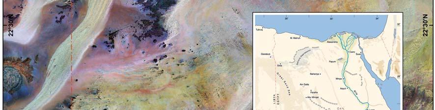

4 Fig. 1 Satellite map of the Gilf Kebir/Jebel Ouenat region showing the postion of the Wadi Sura area. 4
 a combination of laser scanning and digital photogrammetry has been used to collect all geometric information.")
.")
5 2. 3D laser scanning and digital photogrammetry of the Wadi Sura II shelter Due to the complex structure of the shelter s architecture and surface (Figs. 2; 3) a combination of laser scanning and digital photogrammetry has been used to collect all geometric information. Therefore the 3D laser scanner Z+F IMAGER 5006i of Zoller+Fröhlich GmbH has been used (Fig. 4). On each of the 16 viewpoints a full 360 scan has been measured (the shelter s interior is shot from 9 viewpoints, cf. Fig. 5). During this procedure the complete surface was measured contactless by a laser beam in less than 3.5 min. This leads to a point cloud consisting of 50 Mio. individual points (point spacing in range of 10 m = 6 mm). All data were transformed automatically into the northing coordinate system of the site using identical points (Z+F AutoTargets). Thereby three-dimensional coordinates can be listed for every single measured pixel instantly. Beside the data acquisition by using the laser scanner a digital photogrammetric documentation of the shelter s surface has been done using a digital camera NIKON D80 with a 30 mm NIKKOR objective. In combination with a panohead 128 over the horizon shared single images can be generated into one high resolution panoramic picture (cf. Fig. 3). This image can be overlaid with the geometric information of the laser scanner (Fig. 6). Fig. 2 Rock art shelter Wadi Sura II ( Cave of Beasts ) above the 20 m high sand slope (centre). Fig. 3 Panoramic view of the shelter at Wadi Sura II generated from the photographic recording in
. Fig.")
 mapping of ground plan in line-drawing (numbers 1 9")
6 Fig. 4 The surveyor engineer prepares the 3D laser scanner for a 360 scan at one of the viewpoints in the shelter of Wadi Sura II (3D laser scanner Z+F IMAGER 5006i). Fig. 5 (1) 3D view of the Wadi Sura II shelter shown in intensity values; (2) ground plan projection of the shelter generated directly from point clouds; (3) mapping of ground plan in line-drawing (numbers 1 9 mark view points of the laser scanner). 6
 Use of geometric information to equalize images and create photo plans as base for the mapping (Fig.")
 3D information as basis for a grid system to record the rock art figures (Fig. 8).")
7 From this data several research needs of the archaeologists and conservation scientists can be satisfied, many of which could not be realised by means of conventional methods: 2D floor and elevation plans (Fig. 5,3) Use of geometric information to equalize images and create photo plans as base for the mapping (Fig. 5,2) Vertical sections through shelter and ground surface Creation of 3D terrain models (Fig. 5,1) Measuring of figures and decay phenomena Texturized surface model of the shelter (Fig. 7) 3D information as basis for a grid system to record the rock art figures (Fig. 8). Individual rock art figures can be recorded and stored as part of the database with 3D coordinates combined with the figures ID numbers Fig. 6 Sphere shaped projection of a 360 scan in 2D, shown in intensity values (top); sphere shaped projection of a 360 scan in 2D, shown with overlaid colour values (bottom). 7


8 Fig. 7 Section of texturized 3D-model, created by GeoMagic software. Fig. 8 Section of ortho map, created by Z+F LaserControl software. 8
 as well as the area selected for the test recording (in black). In this area (c.")

9 Fig. 9 Straightened section of the W AD I SUR A central part of the Wadi Sura II shelter showing the provisonal grid system in units of 40 x 60 cm (in red) as well as the area selected for the test recording (in black). In this area (c. 5 m2), 533 individual figures were identified and recorded. Segment B4 (in white) in Fig. 10. B4 Fig. 10 Segment B4 with IDs of figures recorded by means of the software application program CaveOne. The circle indicates the position of ID no. 103, a squatting woman (cf. Fig. 11). 9
10 3. Computer-aided rock art recording at Wadi Sura II The detailed recording of the exceedingly rich rock art at Wadi Sura II, encompassing thousands of representations mostly painted, but also engraved or pecked of humans, animals, etc. as well as hundreds of hand stencils, requires special means. All in all, about 5,000 individual figures are visible within an area of c. 18 m in width and up to c. 6 m in hight (cf. Fig. 3), and the projected excavation of the shelter s sand fill most probably will reveal many more. In view of the enormous amount of data to be dealt with when recording each single drawing according to its main characteristics (such as colour, size and style, orientation, shown posture and action, superpositions, body decoration, etc.), and in order to facilitate a subsequent search for individual motifs, characteristics or decorational patterns, a database driven computer system, developed by Reinhold Goss, has been introduced and used on site: CaveOne. This system, although developed specifically for the documentation of the Wadi Sura II rock art, is applicable for the recording, postprocessing and scientific evaluation of other archaeological findings. Based on FileMaker Pro Advanced 10, it allows to record a huge amount of objects and selected object data in short time, even under difficult lighting conditions. Every given attribute of an object can be commented upon and be connected with value-lists that can be adapted or broadened at any time (Fig. 11). The notation of superpositions and possible interactions with other objects or figures, as well as the allocation to individual grid systems and photographs are essential functions (Figs. 9; 10). The possibility of a concurrent working on one database is given by the network ability (PC, Mac) this both in fieldwork as well as in the following processing and evaluation of the data. Another option of the application is an open or restricted access via the internet. Based on the catalogue of attributes that was established during the first field season, 533 individual rock art figures have been entered into this newly developed relational database. These figures belong to an area of c. 5 m 2 in the central part of the rock face, which was already selected for a provisional test recording in spring Using a grid system of units 40 cm high and 60 cm wide turned out to be appropriate in regard to a manageable number of figures within a segment (Fig. 9). Compared to 489 figures identified and numbered within this area in spring 2009, 44 additional figures (or traces thereof) could be identified and recorded during this season. This illustrates the necessity to recheck the recording of each segment on site, especially when this has been done abroad by using digital photographs only (and most of the future recording will be achieved that way). But even on site, some faint traces of colour, especially white, can only be detected and adequately interpreted under favourable lighting conditions, depending on the time of day, and whether these traces are the remains of a faded figure or just smudges of paint, or even part of the natural coloration of the rock face, is sometimes not easy to determine. For example, close examination of what appeared, at first glance, as rather amorphous whitish patches revealed a number of isolated representations of single bows, in which some arrows had been placed. These bows and arrows, not connected to any specific human figures, are obviously to be interpreted as laid aside in what might be a festival scene, attended by both men and women (Fig. 10). The visual enhancement of faded colours by modern image processing (applying, e.g., the DStretch/ImageJ program, cf. Fouilleux 2007) may contribute to a better assessment of such traces. In addition to the process of feeding data and observations into the computer, pictures of selected motifs and details have been taken in order to exemplify, e.g., the different styles of human representation and the spectrum of body decoration depicted. Moreover, the various wild animal species shown in the rock art, including hybrid creatures (the so-called 10


11 monsters or headless beasts ), have been documented that way, as was the variety of stencils, used colours, natural and intentional damages, etc. This collection of samples will help to establish more standardized but still expandable value-lists to be used for the further proceedings, when a straightened digital photo recording in high resolution of the whole rock face as well as an overall grid system are finally processed. Fig. 11 Screenshot of CaveOne s recording file for ID no. 103 and some pop-up windows implemented in the system to facilitate a fast recording. 11
12 4. Geological setting and investigations into rock composition, physical properties, and state of conservation at Wadi Sura II The cave consists of sandstone of Silurian age (Um Ras Formation (?); Klitzsch et al. 1987: sheet NF 35 NW, Gilf Kebir Plateau), which is only little consolidated by diagenetic processes. The region is characterized by an orthogonal joint pattern with generally NW-SE and NE-SW, and also NS-EW running faults and joints. They might have influenced the cave formation and some of them are causing deformation and deterioration. The cave is affected by several cracks, three big joints are crossing the central part of the shelter (cf. Fig. 3), the joint planes have an inclination between 40 and 60 towards East and they are running ± NS. Part of the deterioration in the cave is closely connected to these joints. Additionally the generated surface is disturbed by folds. The surrounding mountains which are formed like a big trough show mega scaling and alveolisation or honey comb weathering to a big extend; alveolisation might result from soluble salt movement in the bedrock. The orientation of the back wall of the cave varies between 80 (west side) and 180 (east side) with an inclination towards north under an angle of 40 to 60. Non destructive tests have been carried out to describe the composition of the stone and its physical behavior. Stone samples from the surrounding area have been collected to investigate the mineralogy by microscopic analysis. The components of the painting bearing rock are mainly whitish coarse grained Quartz, poorly compacted with only little binder. Therefore the sandstone is sanding on exposed surfaces. The surface of the shelter is formed by a very thin brownish skin or crust, easily distinguishable under the magnification glass; it can be assumed that iron is enriched in the surface zone of the cave. This crust displays the solid layer under the painted rock art. The sandstone is very porous, tests with the Karsten tube show rapid water absorption: on the crust the absorption is up to 1.25 ml in 1 minute, on surfaces without the brownish crust the absorption is up to 5 ml in 20 seconds, which is an enormous amount. This gives a clear hint for the amount of consolidation agent which has to be allocated for the consolidation of the sanding stone. Recording and cataloguing relevant weathering forms and damage symptoms of the paintings and the underlying rock surfaces and stones to which paints were applied are primary field tasks of the Wadi Sura project. The major aims of this study can be summarized as follows: (1) Evaluation of the need and feasibility of possible conservation measures; (2) Tracing of recent and changing palaeo-enviromental conditions and their chronostratigraphical relevance regarding the development of the paintings. A great variety of weathering forms can be observed in the cave; all of them compromise the precious paintings. Main deterioration phenomenon are natural crust development, reduction, detachment and break open of the brownish crust, sanding, crack and joint development (see above), contour scaling, flaking, breakage, discoloration and biological contamination like wasp nests. A catalogue of the different weathering forms has been defined and they are compiled in a legend for the mapping and evaluation of weathering forms and the studies concerning the cause and dynamics of weathering. 12

13 Fig. 12 Mapping of weathering/damage symptoms at Wadi Sura II: Panoramic view of the shelter showing natural crusts and crust reduction. Horizontal bands of crust reduction probably result from sand abrasion due to the prevailing west-east wind regime in the shelter Natural crust development Natural crusts due to chalk iron deposition in the surface near layers of the bedrock and probably salt efflorescence are one of the major natural damage symptoms at Wadi Sura II (Fig. 12). Crusts cover almost all parts of the rock surface of the shelter with varying intensity depending on the changing inclination of the surface. Crusts appear in stratigraphical positions that both underlie and overlap the prehistoric paintings indicating crust development during the prehistoric period. As an indicator of higher water flow and water movement in the rock compared to present day conditions, the crusts point to increased humid conditions during their development, and as such support the aforementioned chrono-stratigraphical interpretation of a development that primarily took place during the Holocene humid period Crust reduction, detachment and break open of the brownish crust Large-scale crust reduction can be observed in a c. 10 m long bright-toned horizontal band c. 1 2 m above the current ground level of the Wadi Sura II shelter (Fig. 12). Both, crusts as well as paintings, have been reduced within this area probably due to sand abrasion. The clear cut zoning of this abrasion phenomenon probably indicate the prevailing local wind regime within the shelter blowing predominantly from west to east along the back wall of the shelter. Very often the crust detaches or breaks open in a close relation to the cracks, joints and folds and the bedrock underneath is sanding to a great extend. Further investigations concerning these phenomena have to be carried out in the future Wasp nests A special type of natural damage symptoms are wasp nests or single combs hanging from the rock wall or overhang (Figs. 13; 14). At some places, they can overlap paintings (such as the beast in Fig. 14), but there are also remains of a wasp nest which are covered by the spray 13


14 of a hand stencil (Fig. 13). Because wasps largely do not occur in present-day hyper-arid conditions in the Western Desert, wasp-building probably took place under more favourable climatic conditions, possibly during or shortly after the prehistoric occupation of the area Pecking marks and surface grinding Aside from natural phenomena, there is a large number of human-made damage symptoms recorded at Wadi Sura II, most of which can be seen as intentionally made. The most spectacular symptoms are pecking marks vandalising specific figures in the corpus of the rock painting, or parts of figures, such as arms, legs, the head or body (Fig. 14). Without doubt these peckings have not been carried out during most recent times, but display obliterating and ritual activity during prehistoric and/or historic times. Another phenomenon is the clearing of the surface and/or older paintings by grinding the rock surface. Often other paintings have been applied where older figures were erased indicating a kind of intentional surface preparation. There are a number of preliminary conclusions that can be drawn in the following from the damage symptoms recorded: Fig. 13 Remains of wasp nest on the rock surface of Wadi Sura II. The nest is superimposed by the red spray of a hand stencil indicating an age prior to the prehistoric depiction. Fig. 14 A beast painted in red with yellow body decoration has been vandalised : three vertical strokes, pecked or incised, obliterate the beast. Note that a wasp nest overlaps both, the beast and the pecking marks, pointing to a rather high age of the vandalism. 14


15 (1) The Cave of Swimmers (Wadi Sura I) shows severe disintegration and sanding of the rock with a total loss of great parts of the rock surface and its paintings due to the stratification, cross bedding and humble diagenetic compaction of the sandstone. In contrast, Wadi Sura II does not show such damage symptoms due to a gradually better compaction of the sandstone at this shelter. This also illustrates that conservation measures at Wadi Sura II are not as essential as at Wadi Sura I. Nevertheless some of the damage processes are active and need to be treated as soon as possible; the locations can be defined easily. Further studies on the conservation materials and methods have to be carried out in advance of any conservation intervention. (2) Many of the damage symptoms recorded at Wadi Sura II date back to prehistoric or historic times, thus predating the tourist invasion of the site that took place after the modern discovery in However, on the long run it is to be excepted that the site will suffer from the rapidly growing number of visitors, in particular as a result of trampling and destabilisation of the sand slope and the rock fall in front of the shelter, as well as due to possible (non-intentional) damage of the paintings (cf. Kuper 2009). 5. Non-destructive pigment analysis of paints in the rock art The use of infrared spectrometry as a contactless method of pigment analysis is well known within the field of conservation sciences. Its application to the study of painted rock art is particularly useful as a non-destructive method where the paint layers do not allow pigment sampling because of reasons in conservation ethics (Fig. 14). The first results of analysing colour pigments at Wadi Sura II suggest that the prehistoric artists have largely used mineral pigments without organic binders. The survey in the surroundings of the site illustrated that such pigments occur in varying colours such as red and yellow ochres (haematitic and limonitic earth), as well as white clay in natural sedimentary contexts in the immediate vicinity of Wadi Sura II and at other rock art sites in the area. The comparative analysis of the paintings with samples taken from the natural resources, as well as with those found in archaeological contexts on prehistoric camp sites (Fig. 15), will allow to asses how the paints were made, and if the chemical composition and technique of paints develop throughout the history of the rock art in the area. Fig. 14 Team members of the Cologne Institute for Conservation Sciences analyzing colour spectra by means of non-contact computer integrated infrared spectrometry. Fig. 15 Processing colour pigments: A palette made out of a Gilf B phase potsherd from site 09/10 (c calbc) with remains of red ochre adhering to its inner surface. 15
16 Fig. 16 Transversal arrow heads (made from quartz and chalcedony) excavated at Wadi Sura 09/1-2 indicate the importance of hunting during the Gilf B phase (c calbc). Scale 1:1. 6. Archaeological excavation at Wadi Sura 09/1-2 The test excavation 09/1-2 on the dune slope west of the playa basin in front of the shelter of Wadi Sura II (cf. Kuper et al. 2009) was enlarged to 8 m 2. The excavation yielded a mass of knapping debris from microlithic production preferably made from pebbles of quartz and chalcedony which appear in the adjacent wadi gravels. The lithic material also includes a number of triangles and trapezes used as transversal insets in arrow shafts (Fig. 16). Hunting activity is also attested by bone fragments provisionally identified as small gazelles which were recovered from an ashy layer that, likewise, contained most of the lithic production. Both transversal arrow heads and few tiny potsherds found in connection with the lithic material indicate an age of the assemblage within the Gilf B phase (c calbc). The assemblage of 09/1-2 is of interest, because it represents one of very few microlithic Gilf B inventories actually known from the Wadi Sura study area, while most other lithic assemblages feature a less-diagnostic, informal tool production from local quartzites and quartzitic sandstones. 7. Archaeological survey in the Wadi Sura region During the second field campaign the survey activity in the Wadi Sura micro-region has been intensified, in particular within the unknown valley on the Gilf Kebir plateau to the north of the Wadi Sura II shelter, to the east of Wadi Sura II, and within a small spot in the lowland about 5 km south of Wadi Sura II (Fig. 17). With the closing of the campaign about two third of the entire survey area envisaged for the first two years programme of the Wadi Sura Project has been explored. This was only made possible as areas with extremely low site/artefact density, such as the open plains in the lowland and the uppermost plain plateau surface have received only exemplary field walking, because the immense investigation effort to be spent on walking such areas cannot be compensated by the little results that this survey would produce. The survey has increased the number of survey sites recorded to a total of about 200 (c. 50 sites recorded during the first, 150 during the second field campaign), among them about 60 which yielded potsherds. Although subject to coming verification by detailed examination, more than 90% of the potsherds found may be affiliated to the Gilf B phase (c /4300 calbc), while the later Gilf C pottery (c calbc) is extremely rare (Fig. 18). This now confirms that Wadi Sura had a dominating Gilf B occupation, while Gilf C is significantly more frequent in the south-eastern Gilf Kebir (cf. Schön 1996, Linstädter 2005), as well as at Jebel Ouenat (cf. Kuper & Riemer in press). 16

 and the Cave of Beasts")
17 Fig. 17 Map of the Wadi Sura survey area showing the sites investigated during the 2009 campaigns, as well as the area to be surveyed in The Cave of Swimmers (Wadi Sura I) and the Cave of Beasts (Wadi Sura II [=09/2]) are marked in black. 17
; 2 Wadi Sura 09/15: thin-walled potsherds of Gilf C phase with incised decoration pattern (c. 4400 3000 calbc). Scale 2:3. Fig.")

18 Fig Wadi Sura 09/24: potsherd of Gilf B phase decorated with packed dotted zigzag impressions (c calbc); 2 Wadi Sura 09/15: thin-walled potsherds of Gilf C phase with incised decoration pattern (c calbc). Scale 2:3. Fig. 19 Stone hooks at the drip lines of rock shelters. They were intentionally cut out of the sandstone rock probably to put up equipment, such as water skins or baskets. One of these hooks at the Wadi Sura II shelter is superimposed by the painting of a beast indicating that such hooks can date back to the prehistoric times (cf. Kuper et al. 2009: fig. 10). 18
; bovid with what appears as a bag hanging down from the animal s back (right).")
19 Fig. 20 Wadi Sura 09/101: Rock shelter on the plateau surface of the Gilf Kebir showing numerous engravings of cattle that resembles representations of the cattle herders style in the painted rock art: cow with calf (left); bovid with what appears as a bag hanging down from the animal s back (right). As to the chronology of rock art, it appears now that the archaeological survey can contribute substantially to the dating of the pastoral imagery by means of statistical examination of the survey results. At Wadi Sura, the low number of Gilf C camp sites correlates with the low number of representations of the cattle herders style (cf. Zboray 2009) at the rock art sites in the area. This highly suggests the conclusion that the herder s rock art can largely be affiliated to the Gilf C phase (cf. Riemer 2009). As to the results in landscape archaeology, it is apparent that the distribution of open air camp sites correlates positively with the existence of rock art sites, most of the latter which were already known before the start of the project (cf. Zboray 2005; 2009). This, together with the rather public presentation of rock depictions at the rock art sites, refers to the subsumption that rock art was an integral part of the daily life of the prehistoric groups. The shelters, where rock depictions were applied, often show traces of profane use which were hitherto not reported in the literature, such as goat dung, stone walls for goat keeping, and, in particular, stone hooks carved out of the rock for putting up equipment (Fig. 19). The latter also enabled to identify a number of shelters which lack any traces of rock art, but were occupied during the prehistory for other purposes. Grinding equipment, remains of stone flaking, as well as pottery are often additional objects to be found in close proximity of the shelters, both with or without rock art. Finally it should be mentioned that the second survey campaign led to the discovery of six hitherto unknown rock art sites, two of which were found in the piedmont zone east of Wadi Sura II, whereas the other four were discovered within the unknown valley on the Gilf Kebir plateau (cf. Zboray 2009: WG81 82). One interesting fact is that all rock art sites on the plateau (altogether eight sites resulting from both the first and the second campaign) represent engraved rock art, while paintings clearly dominate the sites of the piedmont zone and the lowland between Wadi Sura I and II. One of the recently discovered sites on the plateau (09/101) is of special interest, because it shows a great number of superimposed figures, among them cattle, giraffes, antelopes, and humans/hunters. The representations of cattle include vivid depictions of cows with udder, cows with calves, herds of cows with individual horn shapes, some of which bear coat designs painted in red colour, and a bovid 19
20 with a kind of bag hanging down from its back (Fig. 20). Many of the engraved cattle representations at this site resemble those from the cattle herders style in the painted rock art (cf. Zboray 2009). Although a complete photo documentation and a test tracing of the depictions on foil were conducted, the site should receive more intensified examination during the next campaign. 8. Gilf Kebir National Park management plan: Compilation of archaeological sites In 2007 the Gilf Kebir area was declared by the Egyptian government as a National Park (Kuper 2007). For establishing a management plan of such a remote area an acquisition of the available archaeological data from the literature as well as from field surveys is of great importance. In turn, the Wadi Sura Project profits from the information, because they form an excellent basis for comparing Wadi Sura with the adjacent regions. Until today some areas of the Gilf Kebir are nearly unknown from an archaeological point of view. During varoius field trips, therefore, members of the Egyptian Environmental Affairs Agency (EEAA) in cooperation with members of the Wadi Sura Project documented the current state-of the-art in the distribution of archaeological sites in parts of the Gilf Kebir National Park. The joint field trips provided a good opportunity for site documentation on the Abu Ras Plateau (NW Gilf Kebir), namely in Wadi Hamra and Wadi Abd el Malik. 9. Botanical studies and palaeoenvironmental relevance Botanical and environmental studies during the campaign in autumn 2009 focused on: (1) Documentation of the environmental situation, including traces of vegetation and wildlife, along the Wadi Sura escarpment. (2) Botanical survey of the access routes leading to the Wadi Sura region, giving particular attention to the principal wadis of the Abu Ras Plateau, Wadi Abd el Malik and Wadi Hamra (Fig. 21) Wadi Sura The botanical work in the Wadi Sura area concentrated on the documentation of plants in the vicinity of the archaeological sites. From observations made along the Wadi Sura escarpment during the last decade it is obvious that this area of the Gilf Kebir received probably the least amount of rainfall compared to other parts of the mountain range. During the visits it was possible to re-discover the only known occurrences of tree growth in the vast foreland around the Wadi Sura caves. These vegetated sites which were first noticed when mapping the western Gilf Kebir in the 1930s, contain several patches of Acacia ehrenbergiana. Today the population of acacias is almost completely dead and fallen, all but two of the remaining individuals have been cut recently, most probably by people passing by on the nearby route to and from Libya. 20
. This part of the wadi is covered by exceptional stands of Acacia, Maerua and Balanites trees. Fig.")
 have been localized which occur particularly along the upper stretches of Wadi Hamra")
21 Fig. 21 Overview showing the upper reaches of Wadi Hamra opposite the rock art site which was discovered during the Frobenius-Rhotert expedition in 1935 (Rhotert 1952: 49 52). This part of the wadi is covered by exceptional stands of Acacia, Maerua and Balanites trees. Fig. 22 Satellite map showing the distribution of tree growth in the NW Gilf Kebir (Abu Ras Plateau). During the field work some 500 individual trees (green dots) have been localized which occur particularly along the upper stretches of Wadi Hamra and Wadi Abd el Malik, while Wadi Sura is almost void of trees. 21
22 Whereas the plains around the southern and south-eastern Gilf Kebir are void of tree growth, the existence of a grove of acacias in the drainage system down-slope the Wadi Sura escarpment is significant. It gives evidence to the favourable ecological position of this area compared to other drainage basins along the Gilf Kebir escarpment Wadi Hamra and Wadi Abd el Malik The ecological survey of the main hydrological pathways draining the plateau north-east of Wadi Sura aimed at the identification of sites providing exceptional conditions for plant growth and wildlife. These ecological niches which are often noticeable by some vigorous acacia trees, are important browsing areas for the wildlife and as such attractive hunting sites, not only today but presumably also during prehistoric times. It was decided to make an inventory of all existing tree growth occurring in the principal valleys north-east of Wadi Sura, as this information will add to the database necessary for the reconstruction of the prehistoric environment. After reaching Wadi Hamra (Fig. 21) and Wadi Abd el Malik, mapping started by GPS localization of isolated trees as well as stretches with more or less continuous tree growth in the valleys (Fig. 22). Distinctive features were used for comparison with data from satellite imagery and for ground tracing, different stands were chosen to determine the ratio of living and dead biomass, to record the type and density of the herbaceous vegetation, and to evaluate individual height, girth and age of the different species occurring. Acknowledgements The joint Wadi Sura project is generously funded by the Deutsche Forschungsgemeinschaft (DFG). It is directed by Dr. Rudolph Kuper, University of Cologne (UC), Institute for Prehistoric Archaeology/Heinrich-Barth-Institute e.v.; and co-directed by Prof. Dr. Hans Leisen, Cologne University of Applied Sciences (CUAS), Cologne Institute for Conservation Sciences; and Prof. Dr. Stephan J. Seidlmayer, Deutsches Archäologisches Institut (DAI), Cairo Department (DAI). Research assistants are Dr. Heiko Riemer, Frank Förster M.A. (UC), and Dipl.-Rest. Sabine Krause (CUAS). The team of the second field season in autumn 2009 comprised: Franziska Bartz M.A. (prehistoric archaeologist, UC), Dipl. Ing. Erik Büttner (surveyor engineer, Z+F GmbH), Dr. Frank Darius (botanist/ecologist, EEAA, Cairo), Ahmed Ebaid B.A. (environmentalist/conservationist, EEAA), Frank Förster M.A. (Egyptologist/archaeologist, UC), Dr. Karin Kindermann (prehistoric archaeologist, EEAA, Cairo), Dipl.-Rest. Sabine Krause (conservator, CUAS), Dr. Rudolph Kuper (prehistoric archaeologist, UC), Prof. Hans Leisen (conservation scientist and geologist, CUAS), and Dr. Heiko Riemer (prehistoric archaeologist, UC). The Supreme Council of Antiquities (SCA) was represented by inspectors Ahmed Gouma and Yasser Farouk. We wish to thank the Permanent Committee of SCA for the permission to carry out the work. We also acknowledge the kind cooperation with and support by EEAA, Z+F GmbH, as well as Reinhold Goss onefile database + internet application development and Claudia Gornik Kommunikationsdesign. The next campaign of the project is scheduled for March/April
23 References Fouilleux, B À la redécouverte des fresques du Tassili: le crocodile, le rhinocéros et le lotori. Sahara 18: (with colour plates E1 11). Klitzsch, E., F.K. List & G. Pöhlmann (eds.) 1987 Geological Map of Egypt 1: (Cairo: Technische Fachhochschule Berlin). Kuper, R Desert Parks in the Eastern Sahara. In: O. Bubenzer, A. Bolten & F. Darius (eds.), Atlas of Cultural and Environmental Change in Arid Africa. Africa Praehistorica 21 (Köln: Heinrich-Barth-Institut) Kuper, R A Paradise off Rules? Sahara 20: Kuper, R. & H. Riemer in press Archaeological survey at western Jebel Ouenat, SE Libya. Libya Antiqua N.S.: Kuper, R., H. Riemer, F. Förster 2009 Report on the first field season of the Wadi Sura Project (Gilf Kebir, SW-Egypt), spring Unpublished report submitted to the Egyptian Supreme Council of Antiquities. Linstädter, J. (ed.) 2005 Wadi Bakht. Landschaftsarchäologie einer Siedlungskammer im Gilf Kebir (SW-Ägypten). Africa Praehistorica 18 (Köln: Heinrich-Barth-Institut). Riemer, H Prehistoric Rock Art Research in the Western Desert of Egypt. Archéo-Nil 19: Rhotert, H Libysche Felsbilder. Ergebnisse der XI. und XII. Deutschen Inner-Afrikanischen Forschungs- Expedition (DIAFE) 1933/1934/1935 (Darmstadt: L.C. Wittich). Schön, W Ausgrabungen im Wadi el Akhdar, Gilf Kebir (SW-Ägypten). Africa Praehistorica 8 (Köln: Heinrich- Barth-Institut). Zboray, A Rock Art of the Libyan Desert (Newbury: Fliegel Jezerniczky Expeditions) [DVD]. Zboray, A Rock Art of the Libyan Desert. Second expanded edition (Newbury: Fliegel Jezerniczky Expeditions) [DVD]. 23
WADI SURA. Field Report Season
 WADI SURA 4 Field Report Season 2011-1 Wadi Sura Project http://www.wadisura.phil-fak.uni-koeln.de Wadi Sura is a joint archaeological and conservation project of University of Cologne (UoC), Institute
New Final Neolithic cemetery E-09-4, Gebel Ramlah Playa, Western Desert of Egypt
 Hunter-Gatherers and Early Food Producing Societies in Northeastern Africa Studies in African Archaeology 14 Poznan Archaeological Museum 2015 Agnieszka Czekaj-Zastawny, Jacek Kabacinski New Final Neolithic
Coso Red Hill and Coso Playa field trip, Prof. Alessandro Grippo, Ph.D.
 HISTORICAL GEOLOGY fall 2016 Professor: Dr. Alessandro Grippo, Ph.D. FIELD TRIP REPORT: Friday, October 21, 2016: Coso Red Hill & Playa, Coso Junction CA YOUR NAME part 1: COSO RED HILL (you can sample
Cooperative Research Centre 389 University of Cologne. Preliminary Report on the Study Season 2004 of the A C A C I A Project in the Western Desert
 Cooperative Research Centre 389 University of Cologne Preliminary Report on the Study Season 2004 of the A C A C I A Project in the Western Desert Report on the study season 2004 of the ACACIA Project
Die Grüne Vergangenheit der Sahara The Green Past of the Sahara Desert
 Die Grüne Vergangenheit der Sahara The Green Past of the Sahara Desert Stefan Kröpelin University of Cologne Institute of Prehistoric Archaeology 12 th Intl. EIKE Conference on Climate Change and Energy
Sediment and sedimentary rocks Sediment
 Sediment and sedimentary rocks Sediment From sediments to sedimentary rocks (transportation, deposition, preservation and lithification) Types of sedimentary rocks (clastic, chemical and organic) Sedimentary
Prehistoric Rock Art Research in the Western Desert of Egypt Heiko Riemer, University of Cologne, Germany
 Prehistoric Rock Art Research in the Western Desert of Egypt Heiko Riemer, University of Cologne, Germany During the most recent past there has been an enormous increase in the discovery of new rock art
Bell Ringer. Are soil and dirt the same material? In your explanation be sure to talk about plants.
 Bell Ringer Are soil and dirt the same material? In your explanation be sure to talk about plants. 5.3 Mass Movements Triggers of Mass Movements The transfer of rock and soil downslope due to gravity is
Laboratory Exercise #4 Geologic Surface Processes in Dry Lands
 Page - 1 Laboratory Exercise #4 Geologic Surface Processes in Dry Lands Section A Overview of Lands with Dry Climates The definition of a dry climate is tied to an understanding of the hydrologic cycle
Prentice Hall EARTH SCIENCE
 Prentice Hall EARTH SCIENCE Tarbuck Lutgens Chapter 7 Glaciers, Desert, and Wind 7.1 Glaciers Types of Glaciers A glacier is a thick ice mass that forms above the snowline over hundreds or thousands of
Glacial landscape. Arid Landscape. Geological feature. Extreme drainage. In this location you should find the following features:
 Glacial landscape In this location you should find the following features: Alluvial fan Braided river End moraines Glacial niche Talus cone U-valley Try to determine the altitude of the tree limit in the
HW #2 Landscape Travel from A to B 12,
 HW #2 Landscape 2016 Section: Name: ate: 1. ase your answer(s) to the following question(s) on the map below, which represents two bridges that cross the Green River. Letters,, and represent locations
Salt Damage at Petra, Jordan: A Study of the Effects of Wind on Salt Distribution and Crystallisation
 Salt Damage at Petra, Jordan: A Study of the Effects of Wind on Salt Distribution and Crystallisation Dr. Fadi Bala awi Assistant Professor Department of Conservation science Queen Rania's Institute of
EROSIONAL FEATURES. reflect
 reflect Have you ever looked at the land around you and wondered what processes shaped what you see? Perhaps you see mountains, valleys, rivers, or canyons. Do you know how long these geologic features
How Do Geology and Physical Streambed Characteristics Affect Water Quality?
 Teacher s Guide How Do Geology and Physical Streambed Characteristics Affect Water Quality? Lesson Description In this lesson, the students research a dynamic, vertical dimension of a watershed - the geological
Your web browser (Safari 7) is out of date. For more security, comfort and the best experience on this site: Update your browser Ignore
 is out of date. For more security, comfort and the best experience on this site: Update your browser Ignore") Your web browser (Safari 7) is out of date. For more security, comfort and the best experience on this site: Update your browser Ignore BEDRO CK For the complete encyclopedic entry with media resources,
Your web browser (Safari 7) is out of date. For more security, comfort and the best experience on this site: Update your browser Ignore BEDRO CK For the complete encyclopedic entry with media resources,
ESC 1000 (Neuhoff) Assignment #2: Rocks and Tectonics
 Assignment #2: Rocks and Tectonics") 1 ESC 1000 (Neuhoff) Assignment #2: Rocks and Tectonics Name: UF ID: Assignment is due by the beginning of class on Wednesday, October 13. This assignment is worth 45 points towards your final grade. Please
1 ESC 1000 (Neuhoff) Assignment #2: Rocks and Tectonics Name: UF ID: Assignment is due by the beginning of class on Wednesday, October 13. This assignment is worth 45 points towards your final grade. Please
Erosional Features. What processes shaped this landscape?
 Have you ever looked at the land around you and wondered what processes shaped what you see? Perhaps you see mountains, valleys, rivers, or canyons. Do you know how long these geologic features have been
Objectives: Define Relative Age, Absolute Age
 S6E5. Students will investigate the scientific view of how the earth s surface is formed. c. Classify rocks by their process of formation. g. Describe how fossils show evidence of the changing surface
Ecoregions Glossary. 7.8B: Changes To Texas Land Earth and Space
 Ecoregions Glossary Ecoregions The term ecoregions was developed by combining the terms ecology and region. Ecology is the study of the interrelationship of organisms and their environments. The term,
North Greenland collection of oblique aerial photographs - (Twin Otter photos)
") North Greenland collection of oblique aerial photographs - (Twin Otter photos) The Geological Survey of Greenland (now part of the Geological Survey of Denmark and Greenland: GEUS) carried out a systematic
North Greenland collection of oblique aerial photographs - (Twin Otter photos) The Geological Survey of Greenland (now part of the Geological Survey of Denmark and Greenland: GEUS) carried out a systematic
Soil Mechanics/Geotechnical Engineering I Prof. Dilip Kumar Baidya Department of Civil Engineering Indian Institute of Technology, Kharagpur
 Soil Mechanics/Geotechnical Engineering I Prof. Dilip Kumar Baidya Department of Civil Engineering Indian Institute of Technology, Kharagpur Lecture - 01 Rock Cycle Good morning. I welcome you to this
UNIT 4 SEDIMENTARY ROCKS
 UNIT 4 SEDIMENTARY ROCKS WHAT ARE SEDIMENTS Sediments are loose Earth materials (unconsolidated materials) such as sand which are transported by the action of water, wind, glacial ice and gravity. These
Section I: Multiple Choice Select the best answer to each question. Mark your final answer on the answer sheet. (1 pt each)
") Sedimentary Rocks & Surface Processes Quest Name: Earth Science 2013 Block: Date: Section I: Multiple Choice Select the best answer to each question. Mark your final answer on the answer sheet. (1 pt each)
Sedimentary Rocks & Surface Processes Quest Name: Earth Science 2013 Block: Date: Section I: Multiple Choice Select the best answer to each question. Mark your final answer on the answer sheet. (1 pt each)
ARCHAEOLOGICAL METHOD FEHMARN STYLE
 ARCHAEOLOGICAL METHOD FEHMARN STYLE Digital archaeology By: Nadja M. K. Mortensen, Prehistoric Archaeologist, Responsible for GIS Overview of the survey area Digital measuring and registration are an important
Data Dictionary for Network of Conservation Areas Transcription Reports from the Colorado Natural Heritage Program
 Data Dictionary for Network of Conservation Areas Transcription Reports from the Colorado Natural Heritage Program This Data Dictionary defines terms used in Network of Conservation Areas (NCA) Reports
Tips for Success on a Test
 Number of Incorrect: Final Grade: Parent Signature: Top Tips for Success on a Test 1. Read the following statements at least two times. 2. Circle the key words in each question/ or statement. (*Remember
Earth systems the big idea guiding questions Chapter 1 & 2 Earth and Earth Systems review notes are in purple
 Earth systems the big idea guiding questions Chapter 1 & 2 Earth and Earth Systems review notes are in purple How can you describe Earth? What are the composition and the structure of the atmosphere? How
How we build reality. In cooperation with the Zamani Project
 How we build reality Case Study Petra, Jordan Company Overview Z+F is one of the world s leading manufacturers in the field of non-contact laser measurement technology. Due to years of research, development
General Editor: Vince Russett
 YCCCART 2014/Y20 North Somerset HER 2015/11 Manual survey using an electronic, hydryostatic level (NIVCOMP) at Wemberham Roman Villa YATTON, CONGRESBURY, CLAVERHAM AND CLEEVE ARCHAEOLOGICAL RESEARCH TEAM
Module 10: Resources and Virginia Geology Topic 4 Content: Virginia Geology Notes
 Virginia is composed of a very diverse landscape that extends from the beaches and barrier islands all of the way to the highly elevated Appalachian Plateau. Geologists have discovered ancient shallow
Name. 4. The diagram below shows a soil profile formed in an area of granite bedrock. Four different soil horizons, A, B, C, and D, are shown.
 Name 1. In the cross section of the hill shown below, which rock units are probably most resistant to weathering? 4. The diagram below shows a soil profile formed in an area of granite bedrock. Four different
Unit 3 Study Guide -- Greenberg science, 6C
 Unit 3 Study Guide -- Greenberg science, 6C Name Pd. Date / / 2018 + +5 extra credit points on the test if submitted complete and correct ON THE TEST DATE. + A copy can be found on my website mgreenberg.weebly.com
Mechanical Weathering
 Weathering is the disintegration and decomposition of material at or near the surface. Erosion is the incorporation and transportation of material by a mobile agent, usually water, wind, or ice. Geologists
Midterm Review. Nata/Lee
 Name: 1. Which statement best supports the theory that all the continents were once a single landmass? (1) Rocks of the ocean ridges are older than those of the adjacent sea floor. (2) Rock and fossil
Chapter 5: Glaciers and Deserts
 I. Glaciers and Glaciation Chapter 5: Glaciers and Deserts A. A thick mass of ice that forms over land from the compaction and recrystallization of snow and shows evidence of past or present flow B. Types
every continent has an extensive dry region! " deserts are as much as 1/3 of Earth s surface!
 deserts! deserts! every continent has an extensive dry region! " deserts are as much as 1/3 of Earth s surface! Hollywood portrayal of vast stretches of sand dune! " Sahara has only 10% covered by sand!
test date Name date Review: Geologic Time & Geologic Procesess-: You will record 1-38 answers on the scan sheet! These are worth 1.
 Review: Geologic Time & Geologic Procesess-: You will record 1-38 answers on the scan sheet! These are worth 1.5 points each Use your EARTH HISTORY CHART Part I. Matching All of the statements match to
Sedimentary Rocks, our most Valuable Rocks. Or, what you will probably find when you are outdoors exploring.
 Sedimentary Rocks, our most Valuable Rocks Or, what you will probably find when you are outdoors exploring. Sedimentary rocks give us evidence to earth s earlier history. We look at processes happening
The physical breakdown and chemical alteration of rocks and minerals at or near Earth s surface.
 The physical breakdown and chemical alteration of rocks and minerals at or near Earth s surface. The material that is chemically and mechanically weathered to yield sediment and soil. Regolith consisting
Pratice Surface Processes Test
 1. The cross section below shows the movement of wind-driven sand particles that strike a partly exposed basalt cobble located at the surface of a windy desert. Which cross section best represents the
Archaeological Work at Tchinguiz Tepe: Verifying the Results of Geophysical Surveying Using Radar
 IPAEB. Volume II Archaeological Work at Tchinguiz Tepe: Verifying the Results of Geophysical Surveying Using Radar Oriol Achón, Enrique Ariño, Diego García, Josep M Gurt and Roger Sala RC The area chosen
Plate 51. Site 035. Collection of remains. Scale is in cm. Plate 50. Site 034. Collection of remains. Scale is in cm
 Plate 48. Site 033. View facing north west Plate 49. Site 034. View facing north Pottery Pottery Ostrich eggshell Plate 50. Site 034. Collection of remains. Scale is in cm Plate 51. Site 035. Collection
The Nature of Sedimentary Rocks
 The Nature of Sedimentary Rocks Sedimentary rocks are composed of: Fragments of other rocks Chemical precipitates Organic matter or biochemically produced materials The Nature of Sedimentary Rocks Sedimentary
DATA SOURCES AND INPUT IN GIS. By Prof. A. Balasubramanian Centre for Advanced Studies in Earth Science, University of Mysore, Mysore
 DATA SOURCES AND INPUT IN GIS By Prof. A. Balasubramanian Centre for Advanced Studies in Earth Science, University of Mysore, Mysore 1 1. GIS stands for 'Geographic Information System'. It is a computer-based
Chapter 5: Weathering and Soils. Fig. 5.14
 Chapter 5: Weathering and Soils Fig. 5.14 OBJECTIVES Recognize that weathering breaks down minerals and rocks and occurs as a result of both mechanical and chemical processes. Explain the processes that
Oil & Gas. From exploration to distribution. Week 1 V05 Origin of hydrocarbon resources part 1. Jean-Pierre Deflandre
 Oil & Gas From exploration to distribution Week 1 V05 Origin of hydrocarbon resources part 1 Jean-Pierre Deflandre W1V5 Origin of hydrocarbon resources1 p. 1 Introduction to hydrocarbon resources You will
Name: Period: Date: ID: A. Circle the choice that best completes the statement or answers the question and write the letter on the blank.
 Name: Period: _ Date: _ ID: A Unit 7 Practice Circle the choice that best completes the statement or answers the question and write the letter on the blank. 1. What term describes the movement of rock
Questions for the Edwards formation
 Name: Professor name: Class Time: The Virtual Field trip is to be completed by your self. You should not work with a partner. This is not group work. Nor should you search for answers on the internet.
Unit 7.2 W.E.D. & Topography Test
 Name: Score: Unit 7.2 W.E.D. & Topography Test 1. 2. 3. 4. 5. 6. 7. 8. 9. 10. 11. 12. 13. 14. 15. 16. 17. 18. 19. 20. 21. 22. 23. 24. 25. 1. The formation of mountains is due mainly to while the destruction
Practice 3rd Quarter Exam Page 1
 Name 1. Which characteristic would most likely remain constant when a limestone cobble is subjected to extensive abrasion? A) shape B) mass C) volume D) composition 2. Which activity demonstrates chemical
What type of land feature is located at Point A? A Cliff B Delta C Mountain D Valley
 1 What type of land feature is located at Point A? A Cliff B Delta C Mountain D Valley Alfred Wegener s theory of continental drift was 2 not accepted by scientists when the theory was first proposed.
Weathering, Erosion and Deposition
 Weathering, Erosion and Deposition Shaping the Earth s Surface Weathering the process of breaking down rocks into smaller fragments Erosion the transport of rock fragments from one location to another
Name: Mid-Year Review #2 SAR
 Name: Mid-Year Review #2 SAR Base your answers to questions 1 through 3 on on the diagram below, which shows laboratory materials used for an investigation of the effects of sediment size on permeability,
Lecture Outlines PowerPoint. Chapter 6 Earth Science 11e Tarbuck/Lutgens
 Lecture Outlines PowerPoint Chapter 6 Earth Science 11e Tarbuck/Lutgens 2006 Pearson Prentice Hall This work is protected by United States copyright laws and is provided solely for the use of instructors
B) color B) Sediment must be compacted and cemented before it can change to sedimentary rock. D) igneous, metamorphic, and sedimentary rocks
 color B) Sediment must be compacted and cemented before it can change to sedimentary rock. D) igneous, metamorphic, and sedimentary rocks") 1. Which characteristic of nonsedimentary rocks would provide the least evidence about the environment in which the rocks were formed? A) structure B) color C) crystal size D) mineral composition 2. Which
1. Which characteristic of nonsedimentary rocks would provide the least evidence about the environment in which the rocks were formed? A) structure B) color C) crystal size D) mineral composition 2. Which
Bats Galore! By ReadWorks
 Bats Galore! Bats Galore! By ReadWorks Imagine watching hundreds of thousands of bats swirl around you, swarming to form a large, black mass that flies off into the horizon. At Carlsbad Caverns in New
Unit 3 Review - Surface Processes
 Unit 3 Review - Surface Processes 1. Why is the surface of Mercury covered with meteor impact craters, while Earth s surface has relatively few craters? A) Mercury is larger than Earth, so it gets hit
Reservoirs and Production
 Lesson Plan Page 1 Topic: Reservoirs and production Topic Overview: Porosity refers to the percentage of holes (pores) in the rock. Permeability is the ability of fluids to travel through porous rocks.
Geography Class XI Fundamentals of Physical Geography Section A Total Periods : 140 Total Marks : 70. Periods Topic Subject Matter Geographical Skills
 Geography Class XI Fundamentals of Physical Geography Section A Total Periods : 140 Total Marks : 70 Sr. No. 01 Periods Topic Subject Matter Geographical Skills Nature and Scope Definition, nature, i)
Inside and Outside Carlsbad Caverns
 by ReadWorks Imagine watching hundreds of thousands of bats swirl around you, swarming to form a large, black mass that flies off into the horizon. At Carlsbad Caverns in New Mexico, this scene is a regular
This Unit is suitable for candidates with no previous archaeological experience but who have an interest in history and/or archaeology.
 National Unit specification: general information Unit code: H29B 12 Superclass: DC Publication date: August 2012 Source: Scottish Qualifications Authority Version: 01 Summary This Unit introduces candidates
Sediment. Weathering: mechanical and chemical decomposition and disintegration of rock and minerals at the surface
 Sediment Some basic terminology Weathering: mechanical and chemical decomposition and disintegration of rock and minerals at the surface Erosion: removal of weathered rock and minerals from one place to
Archaeological Survey and Evaluation at 8954 El Dorado Parkway, El Cajon, San Diego County, California
 April 16, 2013 Ms. Andrea Bitterling Helix Environmental Planning, Inc. 7578 El Cajon Blvd., Suite 200 El Cajon, California 91942 Re: Archaeological Survey and Evaluation at 8954 El Dorado Parkway, El
Preparing Landslide Inventory Maps using Virtual Globes
 Introduction: A landslide is the movement of a mass of rock, debris, or earth down a slope, under the influence of gravity. Landslides can be caused by different phenomena, including intense or prolonged
Rocks Rock- A group of minerals, glass, mineroid bound together in some way.
 Rocks Rock- A group of minerals, glass, mineroid bound together in some way. All rocks fit into one of three categories: Igneous- formed by the cooling and hardening of hot molten rock Sedimentary- formed
Field Trip to Tempe Butte
 Synopsis Field Trip to Tempe Butte So far you have been identifying rocks and mapping their locations without actually going there. Now it is your chance to put it all together and see real rocks out in
Science and Health EFFECT OF EROSION ON THE CONDITION OF SOIL AND LAND SHAPE
 4 Module 51 Science and Health EFFECT OF EROSION ON THE CONDITION OF SOIL AND LAND SHAPE A DepEd-BEAM Distance Learning Program supported by the Australian Agency for International Development To the Learner
Bowen s Chemical Stability Series
 Lab 5 - Identification of Sedimentary Rocks Page - Introduction Sedimentary rocks are the second great rock group. Although they make up only a small percentage of the rocks in the earth s crust (~5%)
The Upper Palaeolithic of North China Chaisi Locality 7701
 The Upper Palaeolithic of North China Chaisi Locality 7701 Tang Chung Centre for Chinese Archaeology and Art The Chinese University of Hong Kong 1 LOCATION The site of Chaisi is located at the bank of
UNIT 4: Earth Science Chapter 21: Earth s Changing Surface (pages )
") CORNELL NOTES Directions: You must create a minimum of 5 questions in this column per page (average). Use these to study your notes and prepare for tests and quizzes. Notes will be turned in to your teacher
CORNELL NOTES Directions: You must create a minimum of 5 questions in this column per page (average). Use these to study your notes and prepare for tests and quizzes. Notes will be turned in to your teacher
Earth s History. The principle of states that geologic processes that happened in the past can be explained by current geologic processes.
 Earth s History Date: Been There, Done That What is the principle of uniformitarianism? The principle of states that geologic processes that happened in the past can be explained by current geologic processes.
Sedimentary Rocks, Stratigraphy, and Geologic Time
 Sedimentary Rocks, Stratigraphy, and Geologic Time A rock is any naturally formed, nonliving, coherent aggregate mass of solid matter that constitutes part of a planet, asteroid, moon, or other planetary
Stratigraphy: Establishing a Sequence from Excavated Archaeological Evidence
 Stratigraphy: Establishing a Sequence from Excavated Archaeological Evidence THE PRINCIPLES OF STRATIGRAPHY In order to explain how and why cultural and social forms change through time, archaeologists
Page 1. Weathering & Erosion by Mass Wasting Pre-Test. Name:
 Weathering & Erosion by Mass Wasting Pre-Test 3048-1 - Page 1 Name: 1) As a particle of sediment in a stream breaks into several smaller pieces, the rate of weathering of the sediment will A) increase
Weathering Erosion and Deposition. Presented by Kesler Science
 Weathering Erosion and Deposition Presented by Kesler Science Essential Questions: 1. What effects do weathering, erosion, and deposition have on the environment in ecoregions? Weathering Chemical and
Geologic Mapping Regional Tournament Trial Event
 Geologic Mapping Regional Tournament Trial Event A TEAM OF UP TO: 2 Team Name AVAILABLE TIME: 50 min Required Materials: Each team MUST have a protractor, ruler, non-programmable calculator, colored pencils,
Agate Fossil Beds National Monument
 University of Nebraska - Lincoln DigitalCommons@University of Nebraska - Lincoln U.S. National Park Service Publications and Papers National Park Service 2014 Follow this and additional works at: http://digitalcommons.unl.edu/natlpark
Depositional Environments. Depositional Environments
 Depositional Environments Geographic area in which sediment is deposited Characterized by a combination of geological process & environmental conditions Depositional Environments Geological processes:
GROUND SURFACE VISUALIZATION USING RED RELIEF IMAGE MAP FOR A VARIETY OF MAP SCALES
 GROUND SURFACE VISUALIZATION USING RED RELIEF IMAGE MAP FOR A VARIETY OF MAP SCALES T. Chiba a, B. Hasi a * a Asia Air Survey Co., Ltd., Kawasaki, Japan (has.baator, ta.chiba,)@ajiko.co.jp Commission II,
UNITED NATIONS E/CONF.96/CRP. 5
 UNITED NATIONS E/CONF.96/CRP. 5 ECONOMIC AND SOCIAL COUNCIL Eighth United Nations Regional Cartographic Conference for the Americas New York, 27 June -1 July 2005 Item 5 of the provisional agenda* COUNTRY
1/31/2013. Weathering Includes Physical, Chemical, Biological processes. Weathering Mechanisms. Wind abrasion forming Ventifacts
 Monument Valley, Utah. What weathering processes contributed to the development of these remarkable rock formations? Weathering Includes Physical, Chemical, Biological processes Weathering Mechanisms Physical
Cattaraugus Creek: A Story of Flowing Water and the Geology of the Channel It Flows Through Presentation to West Valley Citizen Task Force 4/27/16
 Cattaraugus Creek: A Story of Flowing Water and the Geology of the Channel It Flows Through Presentation to West Valley Citizen Task Force 4/27/16 Raymond C. Vaughan, Ph.D. What happens if you drop a
The Geology of Two Lights State Park. Cape Elizabeth, Maine
 Maine Geologic Facts and Localities June, 2002 Cape Elizabeth, Maine 43 33 33.48 N, 70 12 13.32 W Text by Henry N. Berry IV and Robert G. Marvinney, Department of Agriculture, Conservation & Forestry 1
1. Base your answer to the following question on The diagram below represents a part of the crystal structure of the mineral kaolinite.
 1. Base your answer to the following question on The diagram below represents a part of the crystal structure of the mineral kaolinite. An arrangement of atoms such as the one shown in the diagram determines
Excavations
 Studies on the Early Paleolithic site of Melka Kunture, Ethiopia - 2004: 449-458. Prehistoric archaeology. The site of Garba IV Excavations 1973-1982 Marcello Piperno 1, Grazia Maria Bulgarelli 2 Introduction
7.5. Weathering Breaks Down Rocks
 7.5 Weathering Breaks Down Rocks Preview the section and read the headings. How many types of weathering will you be learning about in this section? An old cemetery can be an interesting place to visit.
Weathering, Mass Wasting and Karst
 Weathering, Mass Wasting and Karst Capable of wearing down anything that the internal processes can build. Gravity, water, wind and ice Denudation - the overall effect of disintegration, wearing away and
Topic 6: Weathering, Erosion and Erosional-Deposition Systems (workbook p ) Workbook Chapter 4, 5 WEATHERING
 Workbook Chapter 4, 5 WEATHERING") Topic 6: Weathering, Erosion and Erosional-Deposition Systems (workbook p. 95-125) Workbook Chapter 4, 5 THE BIG PICTURE: Weathering, erosion and deposition are processes that cause changes to rock material
Topic 6: Weathering, Erosion and Erosional-Deposition Systems (workbook p. 95-125) Workbook Chapter 4, 5 THE BIG PICTURE: Weathering, erosion and deposition are processes that cause changes to rock material
Terrain Units PALEOGEOGRAPHY: LANDFORM CREATION. Present Geology of NYS. Detailed Geologic Map of NYS
 NYS TOPOGRAPHY Why so? PALEOGEOGRAPHY: LANDFORM CREATION Prof. Anthony Grande AFG 014 Present Geology of NYS Detailed Geologic Map of NYS Generalized Geology Detailed Geology Hot links to the fold out
THE CROOKS GAP HOUSEPIT SITE AND OTHER NEARBY MID-HOLOCENE HOUSEPITS
 Volume 56(1 ), Spring 2012 The Wyoming Archaeologist THE CROOKS GAP HOUSEPIT SITE AND OTHER NEARBY MID-HOLOCENE HOUSEPITS by Craig S. Smith Marcia Peterson INTRODUCTION This article summarizes excavation
A Geological Tour of Tumbledown Mountain, Maine
 Maine Geologic Facts and Localities April, 1998 A Geological Tour of Tumbledown Mountain, Maine 44 45 3.21 N, 70 32 50.24 W Text by Robert G. Marvinney, Department of Agriculture, Conservation & Forestry
Name: Class: Date: Multiple Choice Identify the letter of the choice that best completes the statement or answers the question.
 Name: Class: Date: geology ch 7 test 2008 Multiple Choice Identify the letter of the choice that best completes the statement or answers the question. 1. Which of the following is true about ice sheets?
Surface Processes on the Earth. Rocks, Weathering, Erosion and Soil
 Surface Processes on the Earth Rocks, Weathering, Erosion and Soil ROCKS AND ROCK CYCLE Rock types Three main types of rock Igneous Metamorphic Sedimentary Igneous Form when magma or lava cools and hardens
Chapter 2 Planet Earth
 Chapter 2 Planet Earth Section Notes Earth and the Sun s Energy Water on Earth The Land Close-up The Water Cycle World Almanac Major Eruptions in the Ring of Fire Quick Facts Chapter 2 Visual Summary Video
1. The diagram below shows the stump of a tree whose root grew into a small crack in bedrock and split the rock apart.
 1. The diagram below shows the stump of a tree whose root grew into a small crack in bedrock and split the rock apart. 4. Which process involves either a physical or chemical breakdown of earth materials?
Higher National Unit specification. General information for centres. Geology and Geomorphology. Unit title: Unit code: F3SL 34
 Higher National Unit specification General information for centres Unit title: Geology and Geomorphology Unit code: F3SL 34 Unit purpose: This Unit provides an introduction to geology and geomorphology.
City of Fort Collins: Geology Staff Training, June 2012
 1 City of Fort Collins: Geology Staff Training, June 2012 Levels of Analysis Descriptive (What do you see, feel, hear, etc..) This rock is made of round grains of quartz. Interpretive-- (The detective
RESEARCH METHODOLOGY
 III. RESEARCH METHODOLOGY 3.1. Time and Research Area The field work was taken place in primary forest around Toro village in Lore Lindu National Park, Indonesia. The study area located in 120 o 2 53 120
Internet Interactive Rock Cycle
 Internet Interactive Rock Cycle Directions: Go to the website http://www.uky.edu/as/geology/howell/goodies/elearning/module05swf.swf and answer the questions below. Part I: Igneous Rocks (click on Igneous