CORAL REEFS AND THE EFFECTS OF INCREASING SEA TEMPERATURE SHAAZIA SALINA MOHAMMED NF-POGO
|
|
|
- Alfred Clark
- 6 years ago
- Views:
Transcription
1 CORAL REEFS AND THE EFFECTS OF INCREASING SEA TEMPERATURE SHAAZIA SALINA MOHAMMED NF-POGO
2 Formation of the coral skeleton Carbon dioxide is removed from the atmosphere by dissolving in ocean water and forming carbonic acid. CO 2 (g)+ H 2 O (l) H 2 CO 3 (aq) (carbonic acid) Once dissolved into sea water, carbon dioxide is converted into bicarbonate (HCO 3- ) ions or carbonate (CO 3-2 ) ions. H 2 CO 3 (aq) H + (aq) + HCO 3 - (aq) HCO 3 - (aq) H + (aq) + CO 3-2 (aq) Certain forms of sea life biologically fix bicarbonate with calcium (Ca +2 ) to produce calcium carbonate (CaCO 3 ). Ca +2 (aq)+2hco 3- (aq) CaCO 3 (s)+co 2 (g)+ H 2 O(l) 2


3 A single coral is a colony of many individuals called polyps which are genetically identical Budding process (extratentacular & intratentacular) Multicellular Gastrovascular cavity InfoBooks/Coral-and-Coral-Reefs/Physical-Characteristics No central nervous system 3


4 Zooxanthellae cells provide coral polyps with pigmentation endosymbiotic relationship facilitating nutrient cycling. Coral host provides a home together with inorganic nitrogen and phosphorous Coral host receives ~ 95% of energy in the form of organic compounds and energy rich ATP They live within the gastrodermis of the coral 4
5 There are three main types of corals: Hard Coral/ Hexacoral / Stony Coral/ Hermatypic- These are the reef building corals with scleractinian skeleton comprising of calcium carbonate in the form of crystallized aragonite. Soft Coral/ Alcyonacea / Ahermatypic/ Octocoral- Corals which do not produce calcium carbonate skeletons. They thrive in nutrient-rich waters with less intense light Deep Sea Coralinclude both hard corals and soft corals and do not contain zooxanthellae within their cells because they live too deep to rely upon sunlight. 5
6 Theories of reef formation Chamisso Coral reefs and atolls were formed by corals growing from the ocean floor to the surface of the sea; those on the outside flourished while those in the middle died giving a lagoon. Quoy and Gaimard Reef-building corals only flourish in shallow water and thus atolls were formed by corals growing on the rim of craters of submerged volcanoes. Darwin Subsidence theory leading to his idea of evolution of fringing to barrier to atoll reefs. Daly 1890 s- Glacial theory corals growing up as sea level rose. Modern models 1970 s Plate tectonic model, cyclicity of sea-level fluctuations, and rate of reef growth are all important in reef development. 6


7 Depending on their structural characteristics coral reefs are generally described using three major reef types Fringing reefs


8 Barrier reefs er/view.asp?link=1948&searchterm=martini que&cat= 8


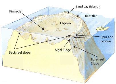
9 Atoll reefs
10 10
11 Other reef formations Patch reef common, isolated, comparatively small reef outcrop, usually within a lagoon or embayment, often circular and surrounded by sand or seagrass Apron reef short reef resembling a fringing reef, but more sloped; extending out and downward from a point or peninsular shore Bank reef linear or semicircular shaped-outline, larger than a patch reef Ribbon reef long, narrow, possibly winding reef, usually associated with an atoll lagoon Table reef isolated reef, approaching an atoll type, but without a lagoon Habili reef specific to the Red Sea; does not reach the surface near enough to cause visible surf; may be a hazard to ships Microatoll community of species of corals; vertical growth limited by average tidal height; growth morphologies offer a low-resolution record of patterns of sea level change; fossilized remains can be dated using radioactive carbon dating and have been used to reconstruct Holocene sea levels Cays small, low-elevation, sandy islands formed on the surface of coral reefs from eroded material that piles up, forming an area above sea level; can be stabilized by plants to become habitable; occur in tropical environments throughout the Pacific, Atlantic and Indian Oceans (including the Caribbean and on the Great Barrier Reef and Belize Barrier Reef), where they provide habitable and agricultural land Seamount or guyot formed when a coral reef on a volcanic island subsides; tops of seamounts are rounded and guyots are flat; flat tops of guyots, or tablemounts, are due to 11 erosion by waves, winds, and atmospheric processes
12 Why are coral reefs important? 12

13 Global distribution of coral reefs 13
14 Corals exists with narrow tolerance limits Requires temperature within the general range of degrees Celsius. Extremely optimal conditions are within the range degrees Celsius. They strive in high salinity (34-39 ppt) Moderate wave action and continuous currents Low of none existent turbidity levels 14


15 Reef are however sensitive species Reefs are environmentally sensitive species. Exposure to natural and anthropogenic threats has been degrading the reef at an alarming rate. 15
 can induce coral bleaching Oil Contamination (Guzman et al.")
16 There are numerous stressors that Increased sea temperature (Glynn & D Croz 1991; Fitt et al. 2001; Coles & Jokiel 1978; Eakin et al. 2010; Brown 1997; McWilliams et al. 2005) can induce coral bleaching Oil Contamination (Guzman et al. 1991) Low Salinity (Goreau 1964; Coles and Jokiel 1978) CORAL BLEACHING Exposure to Low Tide (Vaughan 1914; Yonge and Nicholls 1931b) Sedimentation (Meehan & Ostrander 1997; Phillip and Fabricius 2003) Infectious Disease (Kushmaro el al. 1996, 1998; Ben-Haim and Rosenberg 2002) Increase Irradiance (Lesser et al. 1990) Shaazia S Mohammed Environmental Physics Laboratory (EPL) 16
17 What is coral bleaching? It is a condition that disrupts the symbiosis between the algal symbiont (zooxanthellae) and its coral host. Many corals can recover from bleaching but this may not be so if the events are severe, frequent and prolonged resulting in coral mortality. 17

18 The effects of elevated sea temperature on coral bleaching 18
19 WHY USE SATELLITE DERIVED SST DATASET? IN SITU DATA SATELLITE SST DATA ADVANTAGE DISADVANTAGE ADVANTAGE DISADVANTAGE Data can be taken at different points to determine temperature gradients within the reef. Limited spatial coverage Ability of providing the synoptic view of large areas High temperatures in shallow waters near coast tend to be underestimated. It enlarges the margin of error between one measurement and the next Has been performed routinely Expensive Free and accessible 19
20 Vertical profile of temperature variations with depth during the night and the day (a) represents the vertical profile of temperature at night with low winds and (b) represents the vertical profile of temperature during the daytime with high solar radiation and low winds. 20
21 12:00:00 AM 4:48:00 AM 9:36:00 AM 2:24:00 PM 7:12:00 PM 12:00:00 AM 4:48:00 AM 9:36:00 AM 2:24:00 PM 7:12:00 PM 12:00:00 AM 4:48:00 AM 12:00:00 AM 4:48:00 AM 9:36:00 AM 2:24:00 PM 7:12:00 PM 12:00:00 AM 4:48:00 AM 9:36:00 AM 2:24:00 PM 7:12:00 PM 12:00:00 AM 4:48:00 AM Temperature/ 0 C Temperature/ 0 C Differences between Daytime and Nighttime Sea Temperatures at 2m and 5m benthic areas Date Date Temperature variability at the 2m depth in Buccoo Reef, Tobago from the 23 rd -24 th June, Temperature variability at the 5m depth in Buccoo Reef, Tobago from the 23 rd -24 th June,
22 NOAA CRW has been providing real-time 50km global satellite coral bleaching monitoring since NOAA Coral Reef Watch (CRW) methodology for 50km SST are used to create the following products : 1) Maximum Monthly Mean (MMM) 1) HotSpot (HS) 1) Degree Heating Week (DHW) 22

23 HS- measure the occurrence and magnitude of thermal stress potentially conducive to coral bleaching. This means corals are vulnerable to bleaching when SST exceeds the temperature normally experienced in the hottest month. 23

24 DHW- this basically sums up the HS greater than 1 o C and is recorded over the past 12weeks. It is therefore a cumulative measurement of the intensity and duration of thermal stress. 24
25 Criteria for coral bleaching warning alert HOTSPOTS ( O C) DEGREE HEATING WEEKS ( O C-Weeks) ALERT STRESS HS <=0 -- 0<HS<1 -- NO STRESS WATCH 1<=HS 1<=DHW<4 4<=DHW<8 8<=DHW WARNING ALERT LEVEL1 ALERT LEVEL

26 Global thermal stress for 26/12/

27 Coral reefs monitoring stations around the globe 27

28 Thermal stress observed in Bermuda
29 Pogonian countries monitored by this system Stations 6 Brazil 1 Trinidad & Tobago 2 Cuba 16 Florida (USA) 11 Indonesia 2 India 2 Tanzania 3 Thailand ss_current.txt 29


30 THANK YOU 30
What creates a coral reef? Why are corals able to form huge reefs?
 Marine ecosystems 5: Coral Reefs Unique features The foundation of the ecosystem is produced by living things Reef-building corals Similarities with tropical rain forests Richness and complexity 3-dimensional
MARINE GEOLOGY & GEOGRAPHY
 MARINE GEOLOGY & GEOGRAPHY Bathymetry BATHYMETRY BATHYMETRY THE UNDERWATER EQUIVALENT TO TOPOGRAPHY THE STUDY OF WATER DEPTH A BATHYMETRIC MAP SHOWS FLOOR RELIEF OR TERRAIN AS CONTOUR LINES Bathymetry
CORAL REEFS IN HOT WATER
 CORAL REEFS IN HOT WATER Coral reef ecosystems are in trouble. About 20 percent of the world s coral reefs have already been lost, and that number may climb to 50 percent in the next 20 to 40 years. The
OCEANOGRAPHY II NOTES
 TIDES OCEANOGRAPHY II NOTES MRS. BURKEY EARTH SPACE SCIENCE CY CREEK HS THE RISE AND FALL IN SEA LEVEL IS CALLED A TIDE. CAUSED BY A GIANT WAVE. AVERAGE LOW-TIDE/HIGH-TIDE CYCLE TAKES ABOUT 12 HRS AND
Unit 4 - Water. Earth s Interior. Earth s Interior. Continental Drift. Continental Drift. Continental Drift. Crust. Mantle. Core.
 Unit 4 - Water How did the oceans form? What special adaptations do saltwater organisms have? Where does our water come from? How do humans affect the Earth s water? Crust Rigid outer shell of Earth Oceanic
Chapter 2 Plate Tectonics and the Ocean Floor
 Chapter 2 Plate Tectonics and the Ocean Floor Chapter Overview Much evidence supports plate tectonics theory. The plate tectonics model describes features and processes on Earth. Plate tectonic science
Oceanography. Oceanography is the study of the deep sea and shallow coastal oceans.
 Oceanography Oceanography is the study of the deep sea and shallow coastal oceans. Studying the Ocean Floor To determine the shape and composition of the ocean floor, scientists use techniques such as
Introduction to Oceanography. Chapter 2: Plate Tectonics Overview
 Introduction to Oceanography Chapter 2: Plate Tectonics Overview Much evidence supports plate tectonics theory. The plate tectonics model describes features and processes on Earth. Plate tectonic science
Chapter Overview. Evidence for Continental Drift. Plate Tectonics. Evidence for Continental Drift. Evidence for Continental Drift 9/28/2010
 Chapter Overview CHAPTER 2 Plate Tectonics and the Ocean Floor Much evidence supports plate tectonics theory. Different plate boundaries have different features. Tectonic plates continue to move today.
Small area of the ocean that is partially surrounded by land. The Ocean Basins. Three Major Oceans. Three Major Oceans. What is a SEA?
 The Ocean Basins How Deep is the Ocean? 1 2 Three Major Oceans Three Major Oceans Pacific Atlantic the shallowest ocean (3.3km average depth) Indian second shallowest ocean (3.8km average depth) Pacific
In 1990, 50% of the U.S. population lived within 75 km of a coast. By 2010, 75% of the U.S. population will live within 75 km of a coast.
 In 1990, 50% of the U.S. population lived within 75 km of a coast. By 2010, 75% of the U.S. population will live within 75 km of a coast. High Tech Methods for Surveying the Deep Sea Floor Fig. 20.18 1
Alfred Wegener gave us Continental Drift. Fifty years later...
 CHAPTER 2 Plate Tectonics and the Ocean Floor Plate Tectonics: summary in haiku form Alfred Wegener gave us Continental Drift. Fifty years later... Words Chapter Overview Much evidence supports plate tectonics
Essentials of Oceanography Eleventh Edition
 Chapter Chapter 1 2 Clickers Lecture Essentials of Oceanography Eleventh Edition Plate Tectonics and the Ocean Floor Alan P. Trujillo Harold V. Thurman Chapter Overview Much evidence supports plate tectonics
MULTIPLE CHOICE. Choose the one alternative that best completes the statement or answers the question.
 Geology 300, Physical Geology Spring 2019 Quiz Chapter 18, Seafloor Name MULTIPLE CHOICE. Choose the one alternative that best completes the statement or answers the question. 1) Abyssal fans are made
Oceanography II Notes
 Oceanography II Notes Tides The rise and fall in sea level is called a tide. Caused by a giant wave and the gravitational pull of the moon and sun on the ocean One low-tide/high-tide cycle takes about
MARINE GEOLOGY & GEOGRAPHY
 MARINE GEOLOGY MARINE GEOLOGY & GEOGRAPHY Marine Geology 4 LAYERS OF THE EARTH CRUST THICKNESS: VARIES BETWEEN OCEAN & CONTINENTS 5-40 KM STATE: SOLID ELEMENTS: SILICON, ALUMINUM, CALCIUM, SODIUM, POTASSIUM
Oceanography is the scientific study of oceans Oceans make up over 70% of the Earth s surface
 Oceanography Oceanography is the scientific study of oceans Oceans make up over 70% of the Earth s surface An ocean must be large and have features which set it apart from other oceans (currents, water
ARE YOU READY TO THINK? Look at the first slide THINK PAIR SHARE!
 ARE YOU READY TO THINK? Look at the first slide THINK PAIR SHARE! WHAT PROMINENT FEATURE CAN YOU IDENTIFY IN THIS PICTURE? What do you think the different colors represent? Who might find such a picture
The Impacts of Climate Change on the Coral Reefs of the Caribbean
 The Impacts of Climate Change on the Coral Reefs of the Caribbean Introduction Global climate change has emerged over the past decade as one of the major environmental issues facing countries worldwide.
CHAPTER 2 Plate Tectonics and the Ocean Floor Pearson Education, Inc.
 CHAPTER 2 Plate Tectonics and the Ocean Floor Plate Tectonics Alfred Wegener first proposed in 1912 Called it Continental Drift Evidence for Continental Drift 1. Noted puzzle-like fit of modern continents
Coral Reefs. Organisms and Ecology
 Coral Reefs Organisms and Ecology General Characteristics: Rival tropical rainforests for beauty, richness, complexity Basic structure is made by organisms 3 Dimensional framework home to incredible assortment
The Ocean Floor Chapter 14. Essentials of Geology, 8e. Stan Hatfield and Ken Pinzke Southwestern Illinois College
 The Ocean Floor Chapter 14 Essentials of Geology, 8e Stan Hatfield and Ken Pinzke Southwestern Illinois College The vast world ocean Earth is often referred to as the water planet 71% of Earth s surface
4. In areas where tectonic plates collide, the seafloor has deep. 5. In areas where tectonic plates separate, the seafloor has mid- ocean
 Name Date Hour Table Chapter 14 Lesson One- General Directions: Use the word bank below to complete each statement. NOT all terms are used. abyssal plains brackish water condensation energy freshwater
F. Muller-Karger, M. Eakin, L. Guild, C. Hu, M. Vega, R. Nemani, T. Christensen, L. Wood, C. Ravillious, C. Nim, J. Li, C. Fitzgerald, J. Hendee, L.
 F. Muller-Karger, M. Eakin, L. Guild, C. Hu, M. Vega, R. Nemani, T. Christensen, L. Wood, C. Ravillious, C. Nim, J. Li, C. Fitzgerald, J. Hendee, L. Gramer, S. Lynds Partnerships NOAA NESDIS/CRW-CRCP (Mark
Remote sensing of coral reef and Coral Reef bleaching in the South China Sea
 Remote sensing of coral reef and Coral Reef bleaching in the South China Sea (Lingzis) 唐丹玲 (Tang Dynasty of China) Research Center of Remote Sensing of Marine Ecology/Environment (REMEE) South China Sea
Ocean and Coastal Processes. Ocean Basins. Chapter 20. Ocean Basins and Plates. Ocean Terms. Sea Arch Bay-mouth Bar Spit Tombolo Coast.
 Chapter 20 Ocean Basins and Plates Ocean and Coastal Processes Tide Wave Height Length Period Base Refraction Tsunami Beach Sea stack Ocean Terms Sea Arch Bay-mouth Bar Spit Tombolo Coast Emergent Submergent
Foundations of Earth Science, 6e Lutgens, Tarbuck, & Tasa
 Foundations of Earth Science, 6e Lutgens, Tarbuck, & Tasa Oceans: The Last Frontier Foundations, 6e - Chapter 9 Stan Hatfield Southwestern Illinois College The vast world ocean Earth is often referred
Bleaching interpretation/alert
 Global coral bleaching response and resilience testing programme, September 7, 2007 p 1 of 6 Pilot early warning for regional bleaching warning network WESTERN INDIAN OCEAN DATE OF THIS ALERT: 10 April
Lecture Outline Wednesday - Friday February 14-16, 2018
 Lecture Outline Wednesday - Friday February 14-16, 2018 Quiz 2 scheduled for Friday Feb 23 (Interlude B, Chapters 6,7) Questions? Chapter 6 Pages of the Past: Sedimentary Rocks Key Points for today Be
Chapter 17. Ocean and Coastal Processes
 Chapter 17 Ocean and Coastal Processes Ocean Basins and Plates Ocean Basins Ocean Basins are profoundly different from the continents. Ocean crust is thin and dense and young. New ocean crust is generated
Unit 8 Test Review -- Oceanography
 Unit 8 Test Review -- Oceanography Multiple Choice Identify the choice that best completes the statement or answers the question. D 1. A large body of saline water that may be surrounded by land is a(n)
Chapter 14. Coral Reefs
 Chapter 14 Coral Reefs What is a coral reef? - Coral reefs are massive complex structures made of limestone (CaCO3) deposited by living organisms - Most established coral reefs are between 5,000 and 10,000
The Ocean Floor Earth Science, 13e Chapter 13
 The Ocean Floor Earth Science, 13e Chapter 13 Stanley C. Hatfield Southwestern Illinois College The vast world ocean Earth is often referred to as the blue planet Seventy-one percent of Earth s surface
Map shows 3 main features of ocean floor
 Map shows 3 main features of ocean floor 2017 Pearson Education, Inc. Chapter 3 Marine Provinces 2017 Pearson Education, Inc. 1 Chapter 3 Overview The study of bathymetry determines ocean depths and ocean
What Are Coral Reefs?
 ELA.08.CR.1.9.132 C1 T9 Sample Item Id: ELA.08.CR.1.9.132 Grade/Model: 08 / 1b Claim: 1: Students can read closely and analytically to comprehend a range of increasingly complex literary and informational
Lecture Outlines PowerPoint. Chapter 13 Earth Science 11e Tarbuck/Lutgens
 Lecture Outlines PowerPoint Chapter 13 Earth Science 11e Tarbuck/Lutgens 2006 Pearson Prentice Hall This work is protected by United States copyright laws and is provided solely for the use of instructors
Lecture Marine Provinces
 Lecture Marine Provinces Measuring bathymetry Ocean depths and topography of ocean floor Sounding Rope/wire with heavy weight Known as lead lining Echo sounding Reflection of sound signals 1925 German
Water percolating through hot lava dissolves soluble minerals containing chlorine, bromine and sulphur compounds
 Figure 5 The sources of dissolved ions in sea water. Water falls as rain Compounds containing mainly calcium, magnesium, carbonate and silicate ions are leached from the soil Rivers carry ions in solution
UNIT V WATER (OCEANS)
") UNIT V WATER (OCEANS) This unit deals with Hydrological Cycle Oceans submarine relief; distribution of temperature and salinity; movements of ocean water-waves, tides and currents CHAPTER WATER (OCEANS)
UNIT V WATER (OCEANS) This unit deals with Hydrological Cycle Oceans submarine relief; distribution of temperature and salinity; movements of ocean water-waves, tides and currents CHAPTER WATER (OCEANS)
The surface of the ocean floor is as varied as the land. The five major oceans, from largest to smallest, are
 11.1 Ocean Basins The surface of the ocean floor is as varied as the land. The five major oceans, from largest to smallest, are w the Pacific w the Atlantic w the Indian w the Southern w the Arctic The
Sea Level Rise and Coral Reefs: Predicting Responses. Pamela Hallock College of Marine Science University of South Florida St. Petersburg, FL 33701
 Sea Level Rise and Coral Reefs: Predicting Responses Pamela Hallock College of Marine Science University of South Florida St. Petersburg, FL 33701 Acknowledgments Funded by EPA's Science To Achieve Results
What Goes Around Comes Around: Humankind, the Environmental Crisis, and the Future of Life on Earth
 What Goes Around Comes Around: Humankind, the Environmental Crisis, and the Future of Life on Earth Again Earth As A Closed System Reminder: Earth Sciences 088F Final Exam Saturday, December 9, 2006 7:00
The Marine Environment
 The Marine Environment SECTION 16.1 Shoreline Features In your textbook, read about erosional landforms, beaches, estuaries, longshore currents, and rip currents. For each statement below, write or. 1.
PRINCIPLE OF OCEANOGRAPHY PBBT101 UNIT-1 INTRODUCTION OF OCEANIC ENVIRONMENT. PART-A (2 Marks)
") PRINCIPLE OF OCEANOGRAPHY PBBT101 UNIT-1 INTRODUCTION OF OCEANIC ENVIRONMENT 1. Define marine ecosystem. 2. What is geography? 3. Give two Oceanic zones 4. What is sea? 5. Define oceanography? 6. Enlist
PRINCIPLE OF OCEANOGRAPHY PBBT101 UNIT-1 INTRODUCTION OF OCEANIC ENVIRONMENT 1. Define marine ecosystem. 2. What is geography? 3. Give two Oceanic zones 4. What is sea? 5. Define oceanography? 6. Enlist
Chapter Overview. Bathymetry. Measuring Bathymetry. Measuring Bathymetry
 CHAPTER 3 Marine Provinces Chapter Overview The study of bathymetry determines ocean depths and ocean floor topography. Echo sounding and satellites are efficient bathymetric tools. Most ocean floor features
Ocean facts continued
 Ocean Facts A dynamic system in which many chemical and physical changes take place Formed over millions of years as precipitation filled low areas on Earth called basins and now covers 70% of the Earth
You should be able to identify a few of the key cultures, individuals and expeditions in the history of marine science:
 Ocean History You should be able to identify a few of the key cultures, individuals and expeditions in the history of marine science: Phoenicians Arabs Micronesians Polynesians Aristotle Erikson Columbus
Earth / Environmental Science. Ch. 14 THE OCEAN FLOOR
 Earth / Environmental Science Ch. 14 THE OCEAN FLOOR The Blue Planet Nearly 70% of the Earth s surface is covered by the global ocean It was not until the 1800s that the ocean became an important focus
Bathymetry Measures the vertical distance from the ocean surface to mountains, valleys, plains, and other sea floor features
 1 2 3 4 5 6 7 8 9 10 11 CHAPTER 3 Marine Provinces Chapter Overview The study of bathymetry determines ocean depths and ocean floor topography. Echo sounding and satellites are efficient bathymetric tools.
Almost of Earth is covered by water. On a map, the continents appear as huge islands surrounded by a vast global ocean.
 Earth s Oceans & Ocean Floor Date: Feelin Blue What are Earth s five main oceans? Almost of Earth is covered by water. On a map, the continents appear as huge islands surrounded by a vast global ocean.
Ocean Floor. Continental Margins. Divided into 3 major regions. Continental Margins. Ocean Basins. Mid-Ocean Ridges. Include:
 Ocean Floor Divided into 3 major regions Continental Margins Ocean Basins Mid-Ocean Ridges Continental Margins Include: Continental Shelves Continental Slopes Continental Rise 1 Continental Shelves Part
6th Grade Science Sample Assessment Items S6E3c.
 Composition 6th Grade Science Sample Assessment Items Ocean water differs from freshwater in that it has. A. a lower temperature B. a higher temperature C. a higher concentration of silicon dioxide D.
Oceans. Sea Surface Temperature. Sea Level. Ocean Heat INDICATORS IN THIS CHAPTER
 Oceans INDICATORS IN THIS CHAPTER 36 Ocean Heat Sea Surface Temperature Sea Level The oceans and atmosphere interact constantly both physically and chemically exchanging energy, water, gases, and particles.
OCN 201 Mantle plumes and hot spots
 OCN 201 Mantle plumes and hot spots Question Long-term (>50 million years) changes in sea level are caused by: A. Changes in the volume of water in the ocean B. Changes in the volume of the ocean basins
Status of Coral Reefs in East Asian Seas Region: Edited by KIMURA Tadashi, TUN Karenne and CHOU Loke Ming
 Status of Coral Reefs in East Asian Seas Region: 2018 Edited by KIMURA Tadashi, TUN Karenne and CHOU Loke Ming Front Cover: Shallow coral reef in Sekisei Lagoon, Okinawa, Japan ( C Tadashi Kimura, 2017
MARK SCHEME for the October/November 2015 series 9693 MARINE SCIENCE
 CAMBRIDGE INTERNATIONAL EXAMINATIONS Cambridge International Advanced Subsidiary Level MARK SCHEME for the October/November 2015 series 9693 MARINE SCIENCE 9693/01 Paper 1 (AS Structured Questions), maximum
DIAGRAM 1: Ocean Carbon Cycle DIAGRAM 2: Terrestrial Carbon Cycle
 DIAGRAM 1: Ocean Carbon Cycle DIAGRAM 2: Terrestrial Carbon Cycle DIAGRAM 3: Ocean Monthly CO 2 Flux Molecules of CO 2 enter the ocean by diffusing into the sea surface waters and dissolving a physio-chemical
I. Geological Formation of Oceanic Islands
 I. Geological Formation of Oceanic Islands Start March 11, 2013 I. Geological Formation of Oceanic Islands A. What is an oceanic island? Oceanic Island: No direct, terrestrial connection to continent (now
Australian Coastal Councils Conference
 Australian Coastal Councils Conference 11 March 2015 Estimating Future Coastal Inundation and Erosion Hazards Dr Andrew McCowan Dr Christine Lauchlan-Arrowsmith Warwick Bishop Background Victorian Future
The Sea Floor. Chapter 2
 The Sea Floor Chapter 2 Geography of the Ocean Basins World ocean is the predominant feature on the Earth in total area Northern Hemisphere = 61% of the total area is ocean. Southern Hemisphere = about
Question: What is the primary reason for the great abundance of fish along the Peruvian coast?
 Buzzer Question # 1 Question Type: toss-up Question Format: Multiple Choice Category: Biology What is the primary reason for the great abundance of fish along the Peruvian coast? Answer W: upwelling Answer
10/11/2010. Acceleration due to gravity, a. Bulk Properties Mass = 6 x kg Diameter = 12,756 km Density = 5515 kg/m 3 (mix of rock and iron)
") Acceleration due to gravity, a Bulk Properties Mass = 6 x 10 24 kg Diameter = 12,756 km Density = 5515 kg/m 3 (mix of rock and iron) Escape Velocity, v e Albedo Amount of sunlight reflected back into space
Acceleration due to gravity, a Bulk Properties Mass = 6 x 10 24 kg Diameter = 12,756 km Density = 5515 kg/m 3 (mix of rock and iron) Escape Velocity, v e Albedo Amount of sunlight reflected back into space
NOAA Coral Reef Watch s Decision Support System for Coral Reef Management
 NOAA Coral Reef Watch s Decision Support System for Coral Reef Management Gang Liu 1,2, C. Mark Eakin 1, Jacqueline L. Rauenzahn 1,2, Tyler R. L. Christensen 1,2, Scott F. Heron 2,3, Jianke Li 1,2, William
Indian Ocean Tsunami Warning System: Example from the 12 th September 2007 Tsunami
 Indian Ocean Tsunami Warning System: Example from the 12 th September 2007 Tsunami Charitha Pattiaratchi 1 Professor of Coastal Oceanography, The University of Western Australia Email: chari.pattiaratchi@uwa.edu.au
Directed Reading. Section: The Water Planet. surface is called the a. Earth s ocean. b. Pacific Ocean. c. salt-water ocean. d. global ocean.
 Skills Worksheet Directed Reading Section: The Water Planet 1. The body of salt water covering nearly three-quarters of the Earth s surface is called the a. Earth s ocean. b. Pacific Ocean. c. salt-water
Marine Science and Oceanography
 Marine Science and Oceanography Marine geology- study of the ocean floor Physical oceanography- study of waves, currents, and tides Marine biology study of nature and distribution of marine organisms Chemical
14.2 Ocean Floor Features Mapping the Ocean Floor
 14.2 Ocean Floor Features Mapping the Ocean Floor The ocean floor regions are the continental margins, the ocean basin floor, and the mid-ocean ridge. 14.2 Ocean Floor Features Continental Margins A continental
Earth s Seafloors. Ocean Basins and Continental Margins. Introductory Oceanography Ray Rector - Instructor
 Earth s Seafloors Ocean Basins and Continental Margins Introductory Oceanography Ray Rector - Instructor OCEAN BASINS and CONTINENTAL PLATFORMS Key Concepts I. Earth s rocky surface covered by of two types
Unit 6: The Sea Floor
 Unit 6: The Sea Floor Turn to Page 62 in Introduction to the World s Oceans Study the bathymetric chart What features do you see? How do the Atlantic and Pacific Oceans differ? What do you think accounts
The Marine Environment
 The Marine Environment SECTION 16.1 Shoreline Features In your textbook, read about erosional landforms, beaches, estuaries, longshore currents, and rip currents. For each statement below, write true or
The Coast: Beaches and Shoreline Processes
 1 2 3 4 5 6 7 8 9 The Coast: es and Shoreline Processes Trujillo & Thurman, Chapter 10 Oceanography 101 Chapter Objectives Recognize the various landforms characteristic of beaches and coastal regions.
The Coast: Beaches and Shoreline Processes Trujillo & Thurman, Chapter 10
 The Coast: es and Shoreline Processes Trujillo & Thurman, Chapter 10 Oceanography 101 Chapter Objectives Recognize the various landforms characteristic of beaches and coastal regions. Identify seasonal
Geospatial application in Kiribati
 Geospatial application in Kiribati ICC-21 ST RESAP (9 TH TO 13 TH OCTOBER, 2017) BANGKOK, THAILAND Outline Kiribati Profile Natural disasters in Kiribati Achievements Challenges/Issues Ways forward 1 Kiribati
Full file at
 Essentials of Oceanography, 10e (Trujillo/Keller) Chapter 2 Plate Tectonics and the Ocean Floor Match the term with the appropriate phrase. You may use each answer once, more than once or not at all. A)
Global Warming is a Fact of Life
 RECENT HISTORICAL TEMPERATURE AND TRADE-WIND INVERSION VARIATIONS IN HAWAI I Global Warming is a Fact of Life Tom Giambelluca Geography UH Manoa 1976-2005: 0.177 o C per decade 1906-2005: 0.074 o C per
Coral reef degradation is not associated with local human population density
 Supplementary Information for: Coral reef degradation is not associated with local human population density John F. Bruno 1 and Abel Valdivia 2 1 Department of Biology, The University of North Carolina
Crisis on Coral Reefs Linked to Climate Change
 EOS, TRANSACTIONS, AMERICAN GEOPHYSICAL UNION Volume 82, Number 1, January 2, 2001 Crisis on Coral Reefs Linked to Climate Change Since 1982, coral reefs worldwide have been subjected to an increased frequency
Where is all the water?
 Where is all the water? The distribution of water at the Earth's surface % of total Oceans 97.25 Ice caps and glaciers 2.05 Groundwater 0.68 Lakes 0.01 Soils 0.005 Atmosphere (as vapour) 0.001 Rivers 0.0001
Earth Science Lesson Plan Quarter 2, Week 10, Day 1
 Earth Science Lesson Plan Quarter 2, Week 10, Day 1 Outcomes for Today Standard Focus: PREPARE 1. Background knowledge necessary for today s reading. Beaches are created by the actions of waves, tides,
Science 8 - Water Systems Test - Chapters 1-2
 Science 8 - Water Systems Test - Chapters 1-2 Multiple Choice (30 marks) Identify the choice that best completes the statement or answers the question. 1. What percentage represents the amount of fresh
Coral Reefs. Reef Corals
 Coral Reefs Highly diverse rivals tropical rain forest Biogenic habitat habitat made by living organisms Are found in areas of warm clear water that is also typically nutrient poor Are increasingly threatened
Sea-level Rise on Cape Cod: How Vulnerable Are We? Rob Thieler U.S. Geological Survey Woods Hole, MA
 Sea-level Rise on Cape Cod: How Vulnerable Are We? Rob Thieler U.S. Geological Survey Woods Hole, MA Outline Sea-level and coastal processes Past sea-level change Predictions for the future Coastal responses
Reading Material. See class website. Sediments, from Oceanography M.G. Gross, Prentice-Hall
 Reading Material See class website Sediments, from Oceanography M.G. Gross, Prentice-Hall Materials filling ocean basins Dissolved chemicals especially from rivers and mid-ocean ridges (volcanic eruptions)
Sea level rise and coastal morphological changes on tropical islands New Caledonia and French Polynesia (South Pacific)
") Manuel Garcin, Marissa Yates, Goneri Le Cozannet, Patrice Walker, Vincent Donato Sea level rise and coastal morphological changes on tropical islands New Caledonia and French Polynesia (South Pacific)
Manuel Garcin, Marissa Yates, Goneri Le Cozannet, Patrice Walker, Vincent Donato Sea level rise and coastal morphological changes on tropical islands New Caledonia and French Polynesia (South Pacific)
FINAL EXAM PRACTICE #3: Meteorology, Climate, and Ecology
 FINAL EXAM PRACTICE #3: Meteorology, Climate, and Ecology 1. Clay is watching the weather to prepare for a trip to the beach tomorrow. The forecast predicts that a low-pressure system will move in overnight.
Earth s Continents and Seafloors. GEOL100 Physical Geology Ray Rector - Instructor
 Earth s Continents and Seafloors GEOL100 Physical Geology Ray Rector - Instructor OCEAN BASINS and CONTINENTAL PLATFORMS Key Concepts I. Earth s rocky surface covered by of two types of crust Dense, thin,
Seafloor Morphology. Techniques of Investigation. Bathymetry and Sediment Studies
 Seafloor Morphology I f we select a grid for the surface of the earth (i.e. 5 km 2 ) and assign it an average elevation in relation to sea level, we can construct a graph of elevation versus area of the
UNIT 1: WATER SYSTEMS ON EARTH CHAPTER 2: OCEANS CONTROL THE WATER CYCLE
 UNIT 1: WATER SYSTEMS ON EARTH CHAPTER 2: OCEANS CONTROL THE WATER CYCLE ORIGINS OF OCEAN WATER OCEANS HAVE FILLED OVER HUNDREDS OF MILLIONS OF YEARS SCIENTISTS BELIEVE THE OCEANS ARE MORE THAN 3 BILLION
Most of Earth s surface water originated from outgassing of volcanoes. Icy comets bombarded early Earth, bringing with them frozen water
 Most of Earth s surface water originated from outgassing of volcanoes. Where the water came from is still uncertain Carbonaceous chondrites contain water as hydrous minerals, suggesting some water originated
Lab 7: Sedimentary Structures
 Name: Lab 7: Sedimentary Structures Sedimentary rocks account for a negligibly small fraction of Earth s mass, yet they are commonly encountered because the processes that form them are ubiquitous in the
Coastal Oceanography. Coastal Oceanography. Coastal Waters
 Coastal Oceanography Coastal Oceanography 95% of ocean life is in coastal waters (320 km from shore) Estuaries and wetlands are among most productive ecosystems on Earth Major shipping routes, oil and
OCEAN ZONES. 1. Intertidal Zone 2. Near-Shore Zone 3. Open-Ocean Zone
 OCEAN ZONES 1. Intertidal Zone 2. Near-Shore Zone 3. Open-Ocean Zone Where the Ocean Meets the Land (Place) Intertidal Zone The intertidal zone is the area between the high- and low-tide lines. At high
The Sea Floor and Its Sediments OCEA 101
 The Sea Floor and Its Sediments OCEA 101 Measuring the depth of the ocean 85BC Posidonius measured depth of Med using rope and rock as ~2000m. Same idea used for next 2000 yrs using graduated ropes and
OCEAN ZONES. 1. Intertidal Zone 2. Near-Shore Zone 3. Open-Ocean Zone
 OCEAN ZONES 1. Intertidal Zone 2. Near-Shore Zone 3. Open-Ocean Zone Where the Ocean Meets the Land (Place) Intertidal Zone The intertidal zone is the area between the high- and low-tide lines. At high
Weather & Ocean Currents
 Weather & Ocean Currents Earth is heated unevenly Causes: Earth is round Earth is tilted on an axis Earth s orbit is eliptical Effects: Convection = vertical circular currents caused by temperature differences
Ocean Sciences 101 The Marine Environment OCEA 101 THE MARINE ENVIRONMENT MID-TERM EXAM
 OCEA 101 THE MARINE ENVIRONMENT MID-TERM EXAM Part I. Multiple Choice Questions. Choose the one best answer from the list, and write the letter legibly in the blank to the left of the question. 2 points
Chapter 02 The Sea Floor
 Chapter 02 The Sea Floor Multiple Choice Questions 1. One of the following is not one of the world's major ocean basins: A. Atlantic Ocean B. Arctic Ocean C. Indian Ocean D. Antarctic Ocean E. Pacific
Oceans. PPt. by, Robin D. Seamon
 Oceans PPt. by, Robin D. Seamon Ocean Notes Salt water/ salinity 360 million square miles 3.5 billion years old 100,000 + species 28 degrees to 86 degrees F 7 miles down in some places Mineral composition:
Sea Level Rise in Connecticut A Risk-Informed Approach
 GZA GeoEnvironmental, Inc. CAFM Conference October 25, 2017 Proactive By Design. Our Company Commitment Proactive By Design. Our Company Commitment Sea Level Rise in Connecticut A Risk-Informed Approach
Physiography Ocean Provinces p. 1 Dimensions p. 1 Physiographic Provinces p. 2 Continental Margin Province p. 2 Deep-Ocean Basin Province p.
 Physiography Ocean Provinces p. 1 Dimensions p. 1 Physiographic Provinces p. 2 Continental Margin Province p. 2 Deep-Ocean Basin Province p. 2 Mid-Ocean Ridge Province p. 3 Benthic and Pelagic Provinces