GIS INTEGRATION FOR MICROZONATION HAZARD MAPPING -A CASE STUDY OF BANGALORE CITY, INDIA
|
|
|
- Shonda Underwood
- 6 years ago
- Views:
Transcription
1 GIS INTEGRATION FOR MICROZONATION HAZARD MAPPING -A CASE STUDY OF BANGALORE CITY, INDIA J.N. Narendara Kumar 1, Anbazhagan, P. 2 and T.G. Sitharam 2 1 Sky Group. GIS consultant & Services, Vijayanagar, Bangalore, India Department of Civil Engineering, Indian Institute of Science, Bangalore, India Abstract GIS will provide an effective solution for integrating different layers of information thus providing a useful input for city planning and in particular input to earthquake resistant design of structures in an area. Seismic hazard and microzonation of cities enable to characterize the potential seismic areas that need to be taken into account when designing new structures or retrofitting the existing ones In this paper, the details of seismic hazard analysis and preparation of microzonation maps for Bangalore using Geographical Information System (GIS) have been discussed and presented. Seismic hazard is the study of expected earthquake ground motions at any point on the earth. Microzonation is the process of sub division of region in to number of zones based on the earthquake effects in the local scale. Seismic microzonation is the process of estimating response of soil layers under earthquake excitation and thus the variation of ground motion characteristic on the ground surface. For the seismic microzonation, geotechnical site characterization needs to be assessed at local scale (micro level) along with geology, seismological details, which are further used to assess of the site response and liquefaction susceptibility of the sites. GIS is used as a tool to represent the all possible earthquake hazard parameters in the form of geographical maps, which is most useful for government agencies, non-governmental organizations, business communities and public for planning infrastructures developments, emergency preparedness and management. The microzonation, thus, achieved is envisaged as a tool for GIS landuse planning, hazard management, structural engineering, and insurance purposes. Keywords: GIS, Seismic Microzonation, Peak ground acceleration, Seismic hazard, Site response, Hazard index. Introduction Seismic hazard and microzonation of cities enable to characterize the potential seismic areas that need to be taken into account when designing new structures or retrofitting the existing ones. Study of seismic hazard and preparation of geotechnical microzonation maps will provide an effective solution for city planning and input to earthquake resistant design of structures in an area. Seismic hazard is the study of expected earthquake ground motions at any point on the earth. Microzonation is the process of sub division of region in to number of zones based on the earthquake effects in the local scale. Seismic microzonation is the process of estimating response of soil layers under earthquake excitation and thus the variation of ground motion characteristic on the ground surface. Geotechnical site characterization and assessment of site response during earthquakes is one of the crucial phases of seismic microzonation with respect to ground shaking intensity, attenuation, amplification rating and liquefaction susceptibility. Microzonation mapping of seismic hazards can be expressed in relative or absolute terms, on an urban block-by-block scale, based on local soil conditions (such as soil types) that affect ground shaking levels or vulnerability to soil liquefaction. Such maps would provide general guidelines for integrated planning of cities and in positioning the types of new structures that are most suited to an area, along with information on the relative damage potential of the existing structures in a region. In this study an attempt has been made to map the evaluated hazard parameters using GIS. Application of GIS for mapping of natural hazard is amply demonstrated by many
2 researchers all over the world. Nath (2004) used GIS has integration tool to map seismic ground motion hazard for Sikkim Himalaya in India. In study GIS is used to compile available geotechnical and shallow geophysical data of Bangalore Mahanagar Palike (BMP) to characterize site. The data are analysis and coupled with earthquake hazard and assess the seismic hazard parameters. Finally GIS is used as master tool to represent seismic hazard parameters in the form of maps. These maps will be more useful for filed Engineers, Planners, Emergency service providers, Government officials, Decision makers and others in Natural disaster management officials. GIS as a Tool Geographical Information System (GIS) provides a perfect environment for accomplishing comprehensive regional seismic damage assessment, GIS has the capability to store, manipulate, analyze and display the large amount of required spatial and tabular data. One of the most important features of a geographic information system is the manipulation and analysis of both spatial (graphic) and Non-spatiaol (non-graphic) data. The procedures for data analysis typically found in most GIS programs as follows: Map overlay procedures, including arithmetic, weighted average, comparison, and correlation functions. Spatial connectivity procedures, including proximity functions, optimum route selection and network analysis. Spatial neighborhood statistics, such as slope, aspect ratio, profile and clustering. Measurements of line and arc lengths, of point-to-point distances, of polygon perimeters, areas and volumes. Statistical analysis, including histograms or frequency counts, regressions, correlations and cross-tabulation. Report generation, including maps, charts, graphs, tables and other user-defined information. Figure 1 shows the typical nitration GIS flow chart. Depending on the level of sophistication of a GIS, numerous application-specific analysis functions may exist. These include procedures such as geotechnical data, air pollution dispersion, ground water flow, a highway traffic routing. Most of the systems include some sort of built-in programming capability usually in the form of a softwarespecific macro language. This allows the user to develop a set of functions or analysis procedures that can be stored in a user-defined library. Often, the GIS macro language is very simplified and doesn t have to handle very high-level computational features such as recursion, numerous simulations, subscripted variables, and subroutines. For this reason, most GIS programs have the ability to communicate with external analysis and modeling programs. A system can typically output data in various formats to be used in various external programs such as spreadsheets, word processing, graphics, and other user-specified executable programs. The results of an external analysis can be used by GIS as both graphic and non-graphic data for further manipulation and analysis, or for final report and map generation. With these wide areas of application, GIS play a unique roll for hazard preparedness and management. In this study GIS is used as tool for mapping seismic hazard of Bangalore city.
3 Automated Mapping System MAP Information System Data Base Management System Spatial Modeling System Fully integrated GIS System Non-Spatial Modeling System Analysis and Modeling System Figure 1: The information systems composing a fully integrated GIS (after Frost et al., 1992) Bangalore Bangalore is the capital of the state of Karnataka, occupies the heart of the Mysore Plateau with an average elevation of 920 m. It is located at N E. Synonymous with the IT revolution in India. It has a population of approximately of 6.8 million in the year of Bangalore is India's third-largest city. Bangalore has earned the name of capital city of "Silicon Valley of India", " Pub Capital of India, and City of Gardens among others, with its beautiful parks, avenues, multiplexes and historical monuments, Bangalore now to emerge as India's nano-technology hub. Bangalore is undoubtedly bubbling with life and energy with a salubrious climate. The city has several institutions of higher learning and research. The high-tech industries viz, aerospace, electronics, computer science, information technology etc., have made Bangalore their home due to easy access to vast pool of scientists and engineers. There were over 150 lakes, though most of them are dried up due to erosion and encroachments leaving only 64 at present in an area of 220 sq km. These tanks were once distributed throughout the city for better water supply but presently in a dried up condition and encroached. The tank beds have the silty clay and silty sand with filled soil above, over which buildings/structures have been built. Because of density of population, mushrooming of buildings of all kinds from mud buildings to RCC framed structures and steel construction and, improper and low quality construction practice, Bangalore is vulnerable even against average earthquakes (Sitharam et al. 2006; Sitharam and Anbazhagan 2007). It is mandatory to estimate effects of earthquake in Bangalore. In this paper presets the estimation of earthquake hazard and mapping using GIS tool. GIS has been used in engineering sciences for data collection, interactions, organization and distribution of geological data and maps. The project in engineering sciences will have many types of data sources in which GIS is an invaluable tool for integration of many different types. Visualization is another GIS activity which is very useful in this project. This includes creating

, Contours, Highways, Major roads, Minor roads, Streets, Rail roads, Water bodies, Drains, Landmarks and Bore")
4 maps on screen, producing hard copy maps and delivering maps. The Bangalore map forms the base layer for development of GIS model. The map entities were developed in view of two aspects, firstly for locating the bore logs points to the utmost accuracy on a scale of 1:20000 and secondly for identification of bore logs/data points by end user. The base map was developed with several layers of information. Some of the important layers considered are the boundaries (Outer and Administrative), Contours, Highways, Major roads, Minor roads, Streets, Rail roads, Water bodies, Drains, Landmarks and Bore locations. Digitized map was developed mainly using hard copy of Bangalore guide map, published by Survey of India in 1983 and several other sources from standard publishers were used for reference. Digitization of the map layers was done in AutoCAD and then imported to Arc GIS 1. Few combinations of layers that can be viewed in the form of map with various ground truths such as elevations of locations, drainage pattern and tank locations, typical map is shown in Figures 2. Figure 2 depicts the borehole locations with respect to water features like lakes, tanks, and natural drains, which could be helpful in prediction of soil behavior and also information can be derived for ground water management and planning. In this study also developed the 3-D model of boreholes is described. The boreholes are represented as 3 dimensional objects projecting below the map layer in 0.5m intervals. Also image files of bore logs and properties table has been attached to location in plan. These 3-D boreholes are generated with several layers with a bore location in each layer overlapping one below the other and each layer representing 0.5 m interval of the subsurface. 3-D borehole consists of several donut elements in different layers placed coinciding one below the other. This view gives a visual idea of the depth to which geotechnical data is available in each borehole. Several other important layers are available in the map, which would be of interest to many engineering groups. Dr Vidhana Soudha Corp orate Oute W Bore Figure 1: GIS model of borehole locations with respect to water features Site Characterization Site characterization has also been carried out using measured shear wave velocity with the help of shear wave velocity survey using MASW. MASW (Multichannel Analysis of Surface Wave) is a geophysical method, which generates a shear-wave velocity (Vs) profile (i.e., Vs versus depth) by analyzing Raleigh-type surface waves on a multichannel record (Park et al., 1999; Xia et al.,
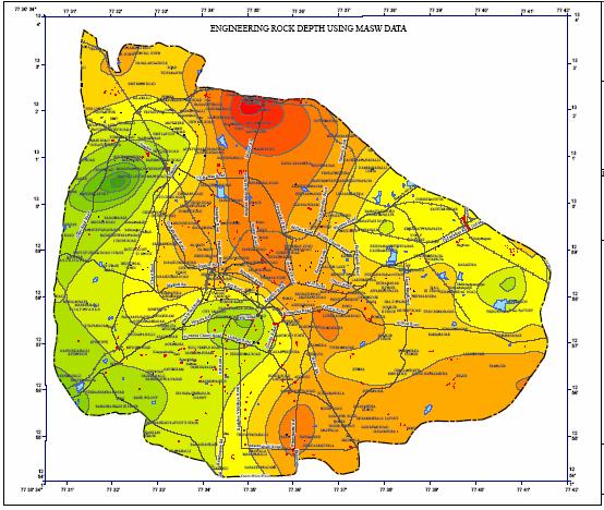
5 1999; Xu et al., 2006). It is a seismic method that can be used for geotechnical characterization of near surface materials (Park et al, 1999; Xia et al, 1999; Miller et al, 1999a; Park et al, 2005a; Kanli et al, 2006). MASW system consisting of 24 channels Geode seismograph with 24 geophones of 4.5 Hz capacity were used in this investigation. The shear wave velocity of Bangalore subsurface soil has been measured and correlation has been developed for shear wave velocity (Vs) with the standard penetration tests (SPT) corrected N values. About 58 onedimensional (1-D) MASW surveys and 20 two-dimensional (2-D) MASW surveys has been carried out with in 220 sq.km Bangalore urban area. Dispersion curves and shear velocity 1-D and 2-D have been evaluated using SurfSeis software. Using 1-dimensional shear wave velocity, the average shear wave velocity of Bangalore soil has been evaluated for depths of 5m, 10m, 15m, 20m, 25m and 30m (Vs 30 ) depths. GIS is used has master tool to preset average shear wave velocity estimated in 2-D map. A typical map is shown in Figure 2 for avenger shear wave velocity at 5m. The sub soil classification has been carried out for local site effect evaluation based on average shear wave velocity of 30m depth (Vs 30 ) of sites using NEHRP (National Earthquake Hazard Research Programme) and IBC (International Building Code) classification. Bangalore falls into site class D type of soil. Mapping clearly indicates that the depth of soil obtained from MASW is closely matching with the soil layers in the bore logs. The measured shear wave velocity at 38 locations close to SPT boreholes, which are used to generate the correlation between the shear wave velocity and corrected N values using a power fit. Also, developed relationship between shear wave velocity and corrected N values corresponds well with the published relationships of Japan Road Association (JRA, 1980). Earthquake Effects Earthquake damage is commonly controlled by three interacting factors- source and path characteristics, local geological and geotechnical conditions and type of structures. Obviously, all of this would require analysis and presentation of a large amount of geological, seismological and geotechnical data. History of earthquakes, faults/sources in the region, attenuation relationships, site characteristics and ground amplification, liquefaction susceptibility are few of the important inputs required. Microzonation has generally been recognized as the most accepted tool in seismic hazard assessment and risk evaluation and it is defined as the zonation with respect to ground motion characteristics taking into account source and site conditions (TC4- ISSMGE, 1999). Making improvements on the conventional macrozonation maps and regional hazard maps, microzonation of a region generates detailed maps that predict the hazard at much lager scales. Damage patterns of many recent earthquakes around the world, including the 1999 Chamoli and 2001 Bhuj earthquakes in India, have demonstrated that the soil conditions at a site can have a major effect on the level of ground shaking. For example, in the Chamoli earthquake, epicenter located at more than 250 km away from Delhi caused moderate damage to some of the buildings built on filled up soil or on soft alluvium. The Bhuj earthquake caused severe damage not only in the epicentral region, but even in Ahmedabad, about 250 km away, which attributed to increased ground shaking of the soft alluvium. Hazard at Rock Level Deterministic Seismic Hazard Analysis (DSHA) for Bangalore has been carried out by considering the past earthquakes, assumed subsurface fault rupture lengths and point source synthetic ground motion model. The seismic sources for region have been collected by considering seismotectonic atlas map of India and lineaments identified from satellite remote sensing images. Analysis of lineaments and faults help in understanding the regional seismotectonic activity of the area. Maximum Credible Earthquake (MCE) has been determined by considering the regional seismotectonic activity in about 350 km radius around Bangalore. Earthquake data are collected
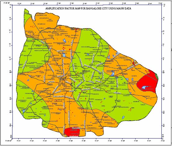
6 from IMD, USGS, NGRI, CESS, ASC and other public domain sites. Source magnitude for each source is chosen from the maximum reported past earthquake close to that source and shortest distance from each source to Bangalore is arrived from the newly prepared seismotectonic map of the area. Using these details, and, attenuation relation developed for southern India by Iyengar and Raghukanth (2004), the peak ground acceleration (PGA) has been estimated. A parametric study has been carried out to find fault subsurface rupture length using past earthquake data and Wells and Coppersmith (1994) relation between the subsurface lengths versus earthquake magnitudes. About more than 60% of earthquake magnitude matches for the subsurface length corresponding to 3.8% of the total length of fault. Assuming 3.8 % of the total length of fault as the subsurface rupture length expected maximum magnitude for each source has been evaluated and PGA is estimated for these magnitudes. Further seismological model developed by Boore (1983, 2003) SMSIM program has been used to generate synthetic ground motions from vulnerable sources identified in above two methods. From the above three approaches maximum PGA of 0.15g was estimated for Bangalore. This value was obtained for a maximum credible earthquake (MCE) having a moment magnitude of 5.1 from a source of Mandya-Channapatna- Bangalore lineament. Considering this lineament and MCE and 850 borehole locations, PGA values are estimated, which are used to prepare rock level PGA with help of GIS tool. Seismic hazard parameter b has been evaluated considering the available earthquake data using (1) Gutenberg Richter (G-R) relationship and (2) Kijko and Sellevoll (1989, 1992) method utilizing extreme and complete catalogs. The b parameter was estimated to be 0.87 from G - R relation and 0.87± 0.03 from Kijko and Sellevoll method. Further, probabilistic seismic hazard analysis for Bangalore region has been carried out considering six seismogenic sources identified in DSHA. From the analysis, mean annual rate of exceedance and cumulative probability hazard curve for Peak Ground Acceleration (PGA) and Spectral Acceleration (SA) have been generated. The quantified hazard values in terms of the rock level peak ground acceleration (PGA) are mapped on a grid size of 0.5 km to 0.5 km. Site Response Using Soil Profiles Bangalore city, a fast growing urban center, with low to moderate earthquake history and highly altered soil structure (due to large reclamation of land) is been the focus of this work. In the present study, an attempt has been made to assess the site response using geotechnical, geophysical data and field studies. The subsurface profiles of the study area within 220sq.km area was represented by 170 geotechnical bore logs and 58 shear wave velocity profiles obtained by MASW survey. The data from these geotechnical and geophysical technique have been used to study the site response. These soil properties and synthetic ground motions for each borehole locations are further used to study the local site effects by conducting one-dimensional ground response analysis using the program SHAKE2000. The response and amplification spectrum have been evaluated for each layer of borehole location. The natural period of the soil column, peak spectral acceleration and frequency at peak spectral acceleration of each borehole has been evaluated and presented as maps. The microzonation maps prepared indicates a medium variation in amplification potential. With the amplification factors varying from 1 to 4.7 and period of soil column from 0.08 to 4.5 seconds, the region is moderately amplifying. A peculiar feature of the study region is that it has reclaimed land from silted lakes/tanks leading to significant variations in ground response. The response spectrum for 5% damping at the ground surface obtained for 160 borehole locations and 58 MASW survey locations clearly indicate that the range of spectral acceleration (SA) at different frequencies varied from 0.01 to 2.17g. The site response studies also carried out experimentally based on recording the ambient noise for a selected period of duration. The noise was recorded at 54 different locations in 220sq.km area of Bangalore city using L4-3D short period sensors (CMG3T) equipped with digital data acquisition
7 system. The predominant frequencies obtained from experimental result range between 1.2 Hz - 11 Hz which matches well with the 1-dimensional ground response analysis presented earlier. Liquefaction Hazard To study the liquefaction hazard in Bangalore, the liquefaction hazard assessment has been carried out using standard penetration test (SPT) data and soil properties. Factor of Safety against liquefaction of soil layer has been evaluated based on the simplified procedure of Seed and Idriss (1971) and subsequent revisions of Seed et al (1983, 1985), Youd et al (2001) and Cetin et al (2004). Cyclic Stress Ratio (CSR) resulting from earthquake loading is calculated by considering moment magnitude of 5.1 and amplified peak ground acceleration. Cyclic Resistant Ratio (CRR) is arrived using the corrected SPT N values and soil properties. Cyclic resistance ratio (CRR) is arrived based on corrected N value from a plot of CRR versus corrected N value from a large amount of laboratory and field data. Factor of safety against liquefaction is calculated using stress ratios and accounting necessary magnitude scaling factor for maximum credible earthquake. A simple spread sheet was developed to carryout the calculation for each bore log. The factor of safety against liquefaction is grouped together for the purpose of classification of Bangalore (220 sq. km) area for a liquefaction hazards. Using 2-D base map of Bangalore city, the liquefaction hazard map was prepared using AutoDesk and ESRI packages. The results are grouped as four groups for mapping and presented in the form of 2-dimensional maps. About 90% of the area in Bangalore have heigher factor of safety and are non-liquefiable. This study shows that Bangalore is safe against liquefaction except at few locations where the overburden is sandy silt with presence of shallow water table. Integration of Maps All above seismic hazard parameters are coupled and assign weight factor in between 3-1to each theme depending on their contribution towards seismic hazard, the higher weight in this case being attached to site response for making it local-specific. The weight of a theme is determined Saaty s Analytical Hierarchy Process (Nath, 2007) is followed. In this method, a matrix of pairwise comparisons (ratio) between the factors is built, which is used to derive the individual normalized weights of each factor. The pairwise comparison is performed by calculating the principal eigenvector of the matrix and the elements of the matrix are in the range of 0 to 1 summing to 1 in each column (Nath 2007.) The weight for each theme is calculated by averaging the values in each row of the matrix. These weights will also sum to 1 and can be used in deriving the weighted sum of rating or scores of each region of cells or polygon of the mapped layers. Since the values within each thematic map/layer vary significantly, those are classified into various ranges or types known as the features of a layer. These features are then assigned ratings or scores within each layer, normalized to 0 1. The layer-wise normalized feature scores for all the themes are given in Table III. All the thematic maps are registered with one another through ground control points and integrated step-by-step using the aggregation method in GIS. The seismological and geological themes when integrated together through similar expression give final microzonation map of Bangalore. Remarks In this study the seismic hazard parameters of rock level PGA using DSHA and PSHA, site characterization parameters, site response parameters and liquefaction parameters are estimated and mapped using GIS as master tool. These parameters can be integrated using GIS integration tool, the final seismic hazard and microzonation map will be prepared for Bangalore. GIS is the master tool for all kind of hazard management.
, Site specific ground response analysis, Special section, Geotechnics and Earthquake Hazards, Current Science, Vol. 87, NO.10, pp. 1354-1362. Sitharam, T. G., Anbazhagan, P.")
8 Reference Sitharam, T. G. and Anbazhagan, P. (2007), Seismic Hazard Analysis for the Bangalore Region, Nat.Hazards, Vol. 40, pp GovindaRaju, L., Ramana, G.V., HanumanthaRao, C., and Sitharam, T.G. (2004), Site specific ground response analysis, Special section, Geotechnics and Earthquake Hazards, Current Science, Vol. 87, NO.10, pp Sitharam, T. G., Anbazhagan, P., and Ganesha Raj, K. (2006), Use of remote sensing and seismotectonic parameters for seismic hazard analysis of Bangalore, Nat. Hazards Earth Syst. Sci., Vol. 6, pp Sitharam, T. G., Anbazhagan, P., Mahesh, G. U., Bharathi, K., and Nischala Reddy, P. (2005), Seismic Hazard Studies using Geotechnical Borehole Data and GIS, Symposium on Seismic Hazard Analysis and Microzonation, September 23-24, Roorkee, pp Sitharam, T.G. and Bansal, B.K. (2007), Proceedings of Workshop on Microzonation, Indian Institute of Science, Bangalore published in Sample Maps:
9
10
CHAPTER 3 METHODOLOGY
 32 CHAPTER 3 METHODOLOGY 3.1 GENERAL In 1910, the seismological society of America identified the three groups of earthquake problems, the associated ground motions and the effect on structures. Indeed
Microzonation of Earthquake Hazard: Indian Experiences
 Microzonation of Earthquake Hazard: Indian Experiences T.G. SITHARAM* AND P.ANBAZHAGAN** * Professor and ** Research Scholar, Department of Civil Engineering, Indian Institute of Science, Bangalore-560
DEVELOPMENT OF EMPIRICAL CORRELATION BETWEEN SHEAR WAVE VELOCITY AND STANDARD PENETRATION RESISTANCE IN SOILS OF CHENNAI CITY
 DEVELOPMENT OF EMPIRICAL CORRELATION BETWEEN SHEAR WAVE VELOCITY AND STANDARD PENETRATION RESISTANCE IN SOILS OF CHENNAI CITY Uma Maheswari R 1, Boominathan A 2 and Dodagoudar G.R 3 1 Research Scholar,
Seismic Microzonation: Principles, Practices and Experiments
 Seismic Microzonation: Principles, Practices and Experiments Sitharam, T. G Professor, Department of Civil Engineering,Indian Institute of Science, Bangalore, India-560012 sitharam@civil.iisc.ernet.in
Seismic hazard analysis and microzonation of Coimbatore Corporation
 Indian Journal of Geo Marine Sciences Vol.46 (11), November 2017, pp. 2207-2214 Seismic hazard analysis and microzonation of Coimbatore Corporation K E Viswanathan 1 & K Elangovan 2 1 Department of Civil
Estimation of Shear Wave Velocity Using Correlations
 Estimation of Shear Wave Velocity Using Correlations Pranav Badrakia P.G. Student, Department of Civil Engineering, Maharashtra Institute of Technology, Pune, Maharashtra, India 1 ABSTRACT: Shear wave
SITE RESPONSE ANALYSES BASED ON SITE SPECIFIC SOIL PROPERTIES USING GEOTECHNICAL AND GEOPHYSICAL TESTS: CORRELATIONS BETWEEN G MAX AND N 60
 4 th International Conference on Earthquake Geotechnical Engineering June 5-8, 7 Paper No.186 SITE RESPONSE ANALYSES BASED ON SITE SPECIFIC SOIL PROPERTIES USING GEOTECHNICAL AND GEOPHYSICAL TESTS: CORRELATIONS
Guidelines for Site-Specific Seismic Hazard Reports for Essential and Hazardous Facilities and Major and Special-Occupancy Structures in Oregon
 Guidelines for Site-Specific Seismic Hazard Reports for Essential and Hazardous Facilities and Major and Special-Occupancy Structures in Oregon By the Oregon Board of Geologist Examiners and the Oregon
AMPLIFICATION FROM ISOSEISMAL MAP AND SITE RESPONSE ANALYSIS
 Abstract No 117 AMPLIFICATION FROM ISOSEISMAL MAP AND SITE RESPONSE ANALYSIS Anbazhagan P Lecturer, Department of Civil Engineering /Indian Institute of Science, Bangalore 560012, Email: anbazhagan@civil.iisc.ernet.in
Introduction to Engineering Seismology Lecture 11
 Lecture 11: Safety of Individual Site; Concept of Seismic Microzonation; Need for Microzonation; Types and Scale; Methodology Topics Introduction to Seismic Microzonation Steps for Seismic Microzonation
Preliminary Earthquake Risk Management Strategy Plan of Eskisehir, Turkey by using GIS
 Preliminary Earthquake Risk Management Strategy Plan of Eskisehir, Turkey by using GIS Metin Altan, Ferah Özturk and Can Ayday Space and Satellite Sciences Research Institute Anadolu University, TURKEY
Micro Seismic Hazard Analysis
 Micro Seismic Hazard Analysis Mark van der Meijde INTERNATIONAL INSTITUTE FOR GEO-INFORMATION SCIENCE AND EARTH OBSERVATION Overview Site effects Soft ground effect Topographic effect Liquefaction Methods
LIQUEFACTION POTENTIAL & POST EARTHQUAKE STABILITY ASSESSMENT. H2J Engineering
 LIQUEFACTION POTENTIAL & POST EARTHQUAKE STABILITY ASSESSMENT Project ID: CEEn_16CPST_13 by H2J Engineering Project Mentor: Tyler Coutu Team Lead: Heidi Decayanan Equipment Specialist: Joshua Peterson
Estimation of hazard assessment by FINSIM for west coast and son narmada faults
 Estimation of hazard assessment by FINSIM for west coast and son narmada faults Shivamanth Angadi 1, Mayank Desai 2 1 Research Scholar, Dept. of Applied Mechanics, SVNIT, SURAT-39007, India 2 Assistant
EVALUATION OF DYNAMIC PROPERTIES AND GROUND PROFILES USING MASW: CORRELATION BETWEEN V S AND N 60
 13 th Symposium on Earthquake Engineering Indian Institute of Technology, Roorkee December 18-20, 2006 Paper No. 008 EVALUATION OF DYNAMIC PROPERTIES AND GROUND PROFILES USING MASW: CORRELATION BETWEEN
REAL-TIME ASSESSMENT OF EARTHQUAKE DISASTER IN YOKOHAMA BASED ON DENSE STRONG-MOTION NETWORK
 REAL-TIME ASSESSMENT OF EARTHQUAKE DISASTER IN YOKOHAMA BASED ON DENSE STRONG-MOTION NETWORK Saburoh MIDORIKAWA 1 And Susumu ABE 2 SUMMARY This paper describes a system for REal-time Assessment of earthquake
Liquefaction and Foundations
 Liquefaction and Foundations Amit Prashant Indian Institute of Technology Gandhinagar Short Course on Seismic Design of Reinforced Concrete Buildings 26 30 November, 2012 What is Liquefaction? Liquefaction
Date: April 2, 2014 Project No.: Prepared For: Mr. Adam Kates CLASSIC COMMUNITIES 1068 E. Meadow Circle Palo Alto, California 94303
 City of Newark - 36120 Ruschin Drive Project Draft Initial Study/Mitigated Negative Declaration Appendix C: Geologic Information FirstCarbon Solutions H:\Client (PN-JN)\4554\45540001\ISMND\45540001 36120
SEISMIC HAZARD ANALYSIS. Instructional Material Complementing FEMA 451, Design Examples Seismic Hazard Analysis 5a - 1
 SEISMIC HAZARD ANALYSIS Instructional Material Complementing FEMA 451, Design Examples Seismic Hazard Analysis 5a - 1 Seismic Hazard Analysis Deterministic procedures Probabilistic procedures USGS hazard
Seismic Geotechnical Hazard Zonation Of Geological Factors
 1 st Workshop of M.E.E.T.I.N.G Project Seismic Geotechnical Hazard Zonation Of Geological Factors Maja Oštri, dipl.ing.geol Dubrovnik, March 3rd-4th 2008 SUBJECT OF THE INVESTIGATION? Geological Factors
EARTHQUAKE HAZARD ASSESSMENT IN KAZAKHSTAN
 EARTHQUAKE HAZARD ASSESSMENT IN KAZAKHSTAN Dr Ilaria Mosca 1 and Dr Natalya Silacheva 2 1 British Geological Survey, Edinburgh (UK) imosca@nerc.ac.uk 2 Institute of Seismology, Almaty (Kazakhstan) silacheva_nat@mail.ru
SURFACE GEOLOGY AND LIQUEFACTION SUSCEPTIBILITY IN THE INNER RIO GRANDE VALLEY NEAR ALBUQUERQUE, NEW MEXICO
 SURFACE GEOLOGY AND LIQUEFACTION SUSCEPTIBILITY IN THE INNER RIO GRANDE VALLEY NEAR ALBUQUERQUE, NEW MEXICO Keith I. Kelson, Christopher S. Hitchcock, and Carolyn E. Randolph William Lettis & Associates,
PROBABILISTIC SEISMIC HAZARD ASSESSMENT OF KARNATAKA STATE
 PROBABILISTIC SEISMIC HAZARD ASSESSMENT OF KARNATAKA STATE Submitted to: CiSTUP Indian Institute of Science Bangalore 560 012 Investigator(s) from IISc: Prof. T. G. Sitharam Professor, Department of Civil
Earthquake maximum magnitude estimation considering regional seismotectonic parameters
 Southern Cross University epublications@scu 23rd Australasian Conference on the Mechanics of Structures and Materials 2014 Earthquake maximum magnitude estimation considering regional seismotectonic parameters
(THIS IS ONLY A SAMPLE REPORT OR APPENDIX OFFERED TO THE USERS OF THE COMPUTER PROGRAM
 C A U T I O N!! (THIS IS ONLY A SAMPLE REPORT OR APPENDIX OFFERED TO THE USERS OF THE COMPUTER PROGRAM EQLique&Settle2. THE AUTHOR IS HEREBY RELEASED OF ANY LIABILITY FOR ANY INCORRECT USE OF THIS SAMPLE
Evaluation of the Liquefaction Potential by In-situ Tests and Laboratory Experiments In Complex Geological Conditions
 Evaluation of the Liquefaction Potential by In-situ Tests and Laboratory Experiments In Complex Geological Conditions V. Sesov, K. Edip & J. Cvetanovska University Ss. Cyril and Methodius, Institute of
5. Probabilistic Seismic Hazard Analysis
 Probabilistic Seismic Hazard Analysis (PSHA) proposed by C.A. Cornell (1968) used to determine the design earthquake for all locations in USA. PSHA gives a relative quantification i of the design earthquake,
Site specific seismic study for a power plant site at Samalkot, Godavari rift basin in Peninsular India
 Site specific seismic study for a power plant site at Samalkot, Godavari rift basin in Peninsular India A. Boominathan, M.G.Vikshalakshie & RM.Subramanian Department of Civil Engineering, Indian Institute
Unique Site Conditions and Response Analysis Challenges in the Central and Eastern U.S.
 Unique Site Conditions and Response Analysis Challenges in the Central and Eastern U.S. James R. Martin, C. Guney Olgun, & Morgan Eddy Civil and Environmental Engineering World Institute for Disaster Risk
LIQUEFACTION ASSESSMENT OF INDUS SANDS USING SHEAR WAVE VELOCITY
 Pakistan Engineering Congress, 69th Annual Session Proceedings 219 LIQUEFACTION ASSESSMENT OF INDUS SANDS USING SHEAR WAVE VELOCITY Sohail Kibria 1, M. Javed 2, Muhammad Ali 3 ABSTRACT A host of procedures
PROTECTING MONUMENTS AND HISTORICAL SETTINGS FROM THE NEXT EARTHQUAKE
 PROTECTING MONUMENTS AND HISTORICAL SETTINGS FROM THE NEXT EARTHQUAKE R.PAPADHMHTRIOU, L.PELLI EUROPEAN CENTER OF PREVENTING & FORECASTING OF EARTHQUAKES Confronting the problem SEISMIC RISK R SEISMIC
SPATIAL VARIABILITY MAPPING OF N-VALUE OF SOILS OF MUMBAI CITY USING ARCGIS
 SPATIAL VARIABILITY MAPPING OF N-VALUE OF SOILS OF MUMBAI CITY USING ARCGIS RESHMA RASKAR - PHULE 1, KSHITIJA NADGOUDA 2 1 Assistant Professor, Department of Civil Engineering, Sardar Patel College of
Interpretive Map Series 24
 Oregon Department of Geology and Mineral Industries Interpretive Map Series 24 Geologic Hazards, Earthquake and Landslide Hazard Maps, and Future Earthquake Damage Estimates for Six Counties in the Mid/Southern
Introduction to GIS I
 Introduction to GIS Introduction How to answer geographical questions such as follows: What is the population of a particular city? What are the characteristics of the soils in a particular land parcel?
Effects of Surface Geology on Seismic Motion
 4 th IASPEI / IAEE International Symposium: Effects of Surface Geology on Seismic Motion August 23 26, 2011 University of California Santa Barbara EFFECTS OF LOCAL GEOLOGY ON EARTHQUAKE GROUND MOTIONS:
Geotechnical Earthquake Engineering
 Geotechnical Earthquake Engineering by Dr. Deepankar Choudhury Humboldt Fellow, JSPS Fellow, BOYSCAST Fellow Professor Department of Civil Engineering IIT Bombay, Powai, Mumbai 400 076, India. Email: dc@civil.iitb.ac.in
SEISMIC VULNERABILITY ASSESSMENT USING HIGH RESOLUTION SATELLITE DATA AND FIELD STUDIES
 P. Anbazhagan, V.T. Giridhar, Ganesha Raj K. and V. Shreedhara 267 SEISMIC VULNERABILITY ASSESSMENT USING HIGH RESOLUTION SATELLITE DATA AND FIELD STUDIES P. Anbazhagan, 1 V.T. Giridhar, 2 Ganesha Raj
Effects of Surface Geology on Seismic Motion
 4 th IASPEI / IAEE International Symposium: Effects of Surface Geology on Seismic Motion August 23 26, 2011! University of California Santa Barbara MICROZONATION OF MONTREAL, VARIABILITY IN SOIL CLASSIFICATION
Sensitivity of Liquefaction Triggering Analysis to Earthquake Magnitude
 Australian Earthquake Engineering Society 2013 Conference, Nov 15-17, Hobart, Tasmania Sensitivity of Liquefaction Triggering Analysis to Earthquake Magnitude Dr Timothy I Mote 1 and Minly M. L. So 2 1.
Application of a GIS for Earthquake Hazard Assessment and Risk Mitigation in Vietnam
 Application of a GIS for Earthquake Hazard Assessment and Risk Mitigation in Vietnam Nguyen Hong Phuong Earthquake Information and Tsunami Warning Centre, VAST OUTLINE Introduction Fault Source Model and
Dr. P. Anbazhagan 1 of 61
 Module 10: Seismic site classification Topics Introduction to seismic Site Characterization, Site characterization data Need for Site Characterization Grids for Site characterization Interpolation of non-filled
Evaluation of Geotechnical Hazards
 Evaluation of Geotechnical Hazards by Geoffrey R. Martin Appendix B: Evaluation of Geotechnical Hazards Describes Evaluation Procedures Soil Liquefaction Soil Settlement Surface Fault Rupture Flooding
We greatly appreciate the review of the manuscript by the anonymous referee#3. We hereby put forth the clarifications as follows.
 Point by point response to the observations & comments of Anonymous Reviewer # 3 on the manuscript titled Seismic Vulnerability & Risk Assessment of Kolkata City, India (ms# nhess-2013-467) We greatly
Development of U. S. National Seismic Hazard Maps and Implementation in the International Building Code
 Development of U. S. National Seismic Hazard Maps and Implementation in the International Building Code Mark D. Petersen (U.S. Geological Survey) http://earthquake.usgs.gov/hazmaps/ Seismic hazard analysis
Seismic Analysis of Structures Prof. T.K. Datta Department of Civil Engineering Indian Institute of Technology, Delhi. Lecture 03 Seismology (Contd.
 Seismic Analysis of Structures Prof. T.K. Datta Department of Civil Engineering Indian Institute of Technology, Delhi Lecture 03 Seismology (Contd.) In the previous lecture, we discussed about the earth
RELATIONSHIP BETWEEN AGE OF GROUND AND LIQUEFACTION OCCURRENCE IN THE 2011 GREAT EAST JAPAN EARTHQUAKE
 Proceedings of the International Symposium on Engineering Lessons Learned from the 2011 Great East Japan Earthquake, March 1-4, 2012, Tokyo, Japan RELATIONSHIP BETWEEN AGE OF GROUND AND LIQUEFACTION OCCURRENCE
Liquefaction Potential Post-Earthquake in Yogyakarta
 The 17 th Southeast Asian Geotechnical Conference Taipei, Taiwan, May 10~13, 2010 Liquefaction Potential Post-Earthquake in Yogyakarta AGUS SETYO MUNTOHAR 1 and S.P.R. WARDANI 2 1 Department of Civil Engineering,
PREDICTION OF SHEAR WAVE VELOCITY USING SPT N VALUE 1
 PREDICTION OF SHEAR WAVE VELOCITY USING SPT N VALUE 1 Himanshu Jhinkwan and 2 P. K. Jain 1 M. Tech Scholar, 2 Professor, Department of Civil Engineering, M.A.N.I.T Bhopal (Madhya Pradesh), India Email:
Estimation of Seismic Hazard Using PSHA in and around National Capital Region (NCR) of India
 of India") Geosciences 2017, 7(4): 109-116 DOI: 10.5923/j.geo.20170704.01 Estimation of Seismic Hazard Using PSHA in and around National Capital Region (NCR) of India S. Sarkar, D. Shanker * Department of Earthquake
Geosciences 2017, 7(4): 109-116 DOI: 10.5923/j.geo.20170704.01 Estimation of Seismic Hazard Using PSHA in and around National Capital Region (NCR) of India S. Sarkar, D. Shanker * Department of Earthquake
A Comparison of Four Geophysical Methods for Determining the Shear Wave Velocity of Soils
 A Comparison of Four Geophysical Methods for Determining the Shear Wave Velocity of Soils Neil Anderson 1, Thanop Thitimakorn 1, David Hoffman 2, Richard Stephenson 2, Ronaldo Luna 2 Geological Sciences
ENGINEERING-SEISMOLOGICAL ASPECTS OF EARTHQUAKE SCENARIO DEVELOPMENT ON THE EXAMPLE OF TASHKENT, UZBEKISTAN
 International Journal of Geology, Earth & Environmental Sciences ISSN: 2277-281 (Online) 218 Vol. 8 (2) May-August, pp. 3-35/Alixanovich ENGINEERING-SEISMOLOGICAL ASPECTS OF EARTHQUAKE SCENARIO DEVELOPMENT
What will a Magnitude 6.0 to 6.8 Earthquake do to the St. Louis Metro Area?
 What will a Magnitude 6.0 to 6.8 Earthquake do to the St. Louis Metro Area? J. David Rogers Natural Hazards Mitigation Center University of Missouri-Rolla USGS Mid-Continent Geographic Science Center Missouri
Integrated site investigation of shallow bedrock sites for seismic site response study
 Southern Cross University epublications@scu 23rd Australasian Conference on the Mechanics of Structures and Materials 2014 Integrated site investigation of shallow bedrock sites for seismic site response
GEOL 380: Earthquake Hazards in the Puget Sound Region (in class and assignment) Due in class Wednesday, Nov 109th
 Due in class Wednesday, Nov 109th") GEOL 380: Earthquake Hazards in the Puget Sound Region (in class and assignment) Due in class Wednesday, Nov 109th The purpose of this exercise/assignment is for you to gain practice and experience in
GEOL 380: Earthquake Hazards in the Puget Sound Region (in class and assignment) Due in class Wednesday, Nov 109th The purpose of this exercise/assignment is for you to gain practice and experience in
Downtown Anchorage Seismic Risk Assessment & Land Use Regulations to Mitigate Seismic Risk
 Prepared for: The Municipality of Anchorage Planning Department and the Geotechnical Advisory Commission Downtown Anchorage Seismic Risk Assessment & Land Use Regulations to Mitigate Seismic Risk Prepared
THE OVERPREDICTION OF LIQUEFACTION HAZARD IN CERTAIN AREAS OF LOW TO MODERATE SEISMICITY
 THE OVERPREDICTION OF LIQUEFACTION HAZARD IN CERTAIN AREAS OF LOW TO MODERATE SEISMICITY Dr. Kevin Franke, Ph.D., P.E., M.ASCE Dept. of Civil and Environmental Engineering Brigham Young University April
Using GIS Software for Identification and Zoning of the Areas Prone to Liquefaction in the Bed Soil of the Dams
 Indian Journal of Science and Technology, Vol 8(S9), 62-66, May 2015 ISSN (Print) : 0974-6846 ISSN (Online) : 0974-5645 DOI: 10.17485/ijst/2015/v8iS9/68555 Using GIS Software for Identification and Zoning
log 4 0.7m log m Seismic Analysis of Structures by TK Dutta, Civil Department, IIT Delhi, New Delhi. Module 1 Seismology Exercise Problems :
 Seismic Analysis of Structures by TK Dutta, Civil Department, IIT Delhi, New Delhi. Module Seismology Exercise Problems :.4. Estimate the probabilities of surface rupture length, rupture area and maximum
PROBABILISTIC LIQUEFACTION HAZARD ANALYSIS IN JAPAN
 SECED 2015 Conference: Earthquake Risk and Engineering towards a Resilient World 9-10 July 2015, Cambridge UK PROBABILISTIC LIQUEFACTION HAZARD ANALYSIS IN JAPAN Tetsushi KURITA 1 and Sei ichiro FUKUSHIMA
EARTHQUAKE-INDUCED SETTLEMENTS IN SATURATED SANDY SOILS
 VOL., NO., AUGUST 7 ISSN 119- -7 Asian Research Publishing Network (ARPN). All rights reserved. EARTHQUAKE-INDUCED SETTLEMENTS IN SATURATED SANDY SOILS C. Y. Lee Department of Civil Engineering, College
Geo-hazard Potential Mapping Using GIS and Artificial Intelligence
 Geo-hazard Potential Mapping Using GIS and Artificial Intelligence Theoretical Background and Uses Case from Namibia Andreas Knobloch 1, Dr Andreas Barth 1, Ellen Dickmayer 1, Israel Hasheela 2, Andreas
PROTECTING MONUMENTS AND HISTORICAL SETTINGS FROM THE NEXT EARTHQUAKE
 PROTECTING MONUMENTS AND HISTORICAL SETTINGS FROM THE NEXT EARTHQUAKE E. PAPADIMITRIOU & L. PELLI EUROPEAN CENTER OF PREVENTING & FORECASTING OF EARTHQUAKES Confronting the problem SEISMIC RISK R SEISMIC
APPLICATIONS OF EARTHQUAKE HAZARD MAPS TO LAND-USE AND EMERGENCY PLANNING EXAMPLES FROM THE PORTLAND AREA
 APPLICATIONS OF EARTHQUAKE HAZARD MAPS TO LAND-USE AND EMERGENCY PLANNING EXAMPLES FROM THE PORTLAND AREA O. Gerald Uba Metro, Portland, Oregon OVERVIEW The extent to which we understand "below ground"
Liquefaction induced ground damage in the Canterbury earthquakes: predictions vs. reality
 Bowen, H. J. & Jacka, M. E. () Proc. th NZGS Geotechnical Symposium. Ed. CY Chin, Queenstown Liquefaction induced ground damage in the Canterbury earthquakes: predictions vs. reality H J Bowen & M E Jacka
Soil Liquefaction Potential Studies of Guwahati City A Critical Review
 Soil Liquefaction Potential Studies of Guwahati City A Critical Review Rupam Saikia 1, Malaya Chetia 2 Undergraduate Student, Department of Civil Engineering, Assam Engineering College, Guwahati, Assam,
SEISMIC MICROZONATION OF A REGION BASED ON SEISMOLOGY AND GEOLOGICAL DATA
 International Journal of Advanced Research in Engineering and Technology (IJARET) Volume 8, Issue 6, November - December 2017, pp. 55 64, Article ID: IJARET_08_06_006 Available online at http://www.iaeme.com/ijaret/issues.asp?jtype=ijaret&vtype=8&itype=6
Comparison of CPT Based Liquefaction Potential and Shear Wave Velocity Maps by Using 3-Dimensional GIS
 Comparison of CPT Based Liquefaction Potential and Shear Wave Velocity Maps by Using 3-Dimensional GIS Muammer Tün, Uğur Avdan, Metin Altan, Can Ayday Anadolu University, Satellite and Space Sciences Research
Geographic Information Systems
 Geographic Information Systems What is a Geographic Information System (GIS)? definition of GIS - An internally referenced, automated, spatial information system for data mapping, management, and analysis
THE 3D SIMULATION INFORMATION SYSTEM FOR ASSESSING THE FLOODING LOST IN KEELUNG RIVER BASIN
 THE 3D SIMULATION INFORMATION SYSTEM FOR ASSESSING THE FLOODING LOST IN KEELUNG RIVER BASIN Kuo-Chung Wen *, Tsung-Hsing Huang ** * Associate Professor, Chinese Culture University, Taipei **Master, Chinese
In seismic Ground Response Analysis (GRA), the effect of local geology is significantly
, the effect of local geology is significantly") 1 2 3 4 5 6 7 8 9 10 11 12 13 14 15 16 17 18 19 20 21 22 23 24 25 INTRODUCTION In seismic Ground Response Analysis (GRA), the effect of local geology is significantly important since the response of any
1 2 3 4 5 6 7 8 9 10 11 12 13 14 15 16 17 18 19 20 21 22 23 24 25 INTRODUCTION In seismic Ground Response Analysis (GRA), the effect of local geology is significantly important since the response of any
Geophysical Site Investigation (Seismic methods) Amit Prashant Indian Institute of Technology Gandhinagar
 Amit Prashant Indian Institute of Technology Gandhinagar") Geophysical Site Investigation (Seismic methods) Amit Prashant Indian Institute of Technology Gandhinagar Short Course on Geotechnical Aspects of Earthquake Engineering 04 08 March, 2013 Seismic Waves
Geophysical Site Investigation (Seismic methods) Amit Prashant Indian Institute of Technology Gandhinagar Short Course on Geotechnical Aspects of Earthquake Engineering 04 08 March, 2013 Seismic Waves
Liquefaction assessments of tailings facilities in low-seismic areas
 Page 1 Liquefaction assessments of tailings facilities in low-seismic areas Holly Rourke SRK Consulting, Perth, WA, Australia Caroline Holmes SRK Consulting, Perth, WA, Australia This paper was first presented
Improved Liquefaction Hazard Evaluation through PLHA. Steven L. Kramer University of Washington
 Improved Liquefaction Hazard Evaluation through PLHA Steven L. Kramer University of Washington il Liquefaction hree primary questions to answer: Is the soil susceptible to liquefaction? If so, is the anticipated
FRIENDS OF THE EEL RIVER
 FRIENDS OF THE EEL RIVER Working for the recovery of our Wild & Scenic River, its fisheries and communities. Frank Blackett, Regional Engineer Office of Energy Projects Division of Dam Safety and Inspections
A METHODOLOGY FOR ASSESSING EARTHQUAKE-INDUCED LANDSLIDE RISK. Agency for the Environmental Protection, ITALY (
 A METHODOLOGY FOR ASSESSING EARTHQUAKE-INDUCED LANDSLIDE RISK Roberto W. Romeo 1, Randall W. Jibson 2 & Antonio Pugliese 3 1 University of Urbino, ITALY (e-mail: rwromeo@uniurb.it) 2 U.S. Geological Survey
Seismic hazard assessment of Chennai city considering local site effects
 Seismic hazard assessment of Chennai city considering local site effects A Boominathan, G R Dodagoudar, A Suganthi and R Uma Maheswari Indian Institute of Technology Madras, Chennai 600 036, India. e-mail:
Evaluating the Seismic Coefficient for Slope Stability Analyses
 Evaluating the Seismic Coefficient for Slope Stability Analyses by Edward Kavazanjian, Jr., Ph.D., P.E.,D.GE., NAE Ira A. Fulton Professor of Geotechnical Engineering School of Sustainable Engineering
Landslide Hazard Zonation Methods: A Critical Review
 International Journal of Civil Engineering Research. ISSN 2278-3652 Volume 5, Number 3 (2014), pp. 215-220 Research India Publications http://www.ripublication.com/ijcer.htm Landslide Hazard Zonation Methods:
Distribution Restriction Statement Approved for public release; distribution is unlimited.
 CECW-ET Engineer Manual 1110-2-6050 Department of the Army U.S. Army Corps of Engineers Washington, DC 20314-1000 EM 1110-2-6050 30 June 1999 Engineering and Design RESPONSE SPECTRA AND SEISMIC ANALYSIS
A NEW SIMPLIFIED CRITERION FOR THE ASSESSMENT OF FIELD LIQUEFACTION POTENTIAL BASED ON DISSIPATED KINETIC ENERGY
 October -7, 008, Beijing, China A NEW SIMPLIFIED CRITERION FOR THE ASSESSMENT OF FIELD LIQUEFACTION POTENTIAL BASED ON DISSIPATED KINETIC ENERGY Y. Jafarian, R. Vakili, A. R. Sadeghi 3, H. Sharafi 4, and
Seismic Site Effects of Soil Amplifications in Bangkok
 Research Article Seismic Site Effects of Soil Amplifications in Bangkok Nakhorn Poovarodom* and Amorntep Jirasakjamroonsri Department of Civil Engineering, Faculty of Engineering, Thammasat University
Applying Hazard Maps to Urban Planning
 Applying Hazard Maps to Urban Planning September 10th, 2014 SAKAI Yuko Disaster Management Expert JICA Study Team for the Metro Cebu Roadmap Study on the Sustainable Urban Development 1 Contents 1. Outline
GIS = Geographic Information Systems;
 What is GIS GIS = Geographic Information Systems; What Information are we talking about? Information about anything that has a place (e.g. locations of features, address of people) on Earth s surface,
Overview of Seismic PHSA Approaches with Emphasis on the Management of Uncertainties
 H4.SMR/1645-29 "2nd Workshop on Earthquake Engineering for Nuclear Facilities: Uncertainties in Seismic Hazard" 14-25 February 2005 Overview of Seismic PHSA Approaches with Emphasis on the Management of
ONE DIMENSIONAL GROUND RESPONSE ANALYSIS OF COASTAL SOIL NEAR NALIYA, KUTCH, GUJARAT
 IGC 29, Guntur, INDIA ONE DIMENSIONAL GROUND RESPONSE ANALYSIS OF COASTAL SOIL NEAR NALIYA, KUTCH, GUJARAT T.P. Thaker Research Scholar, Department of Civil Engineering, Indian Institute of Technology
Estimation of Peak Ground Acceleration for Delhi Region using Finsim, a Finite Fault Simulation Technique
 215 Estimation of Peak Ground Acceleration for Delhi Region using Finsim, a Finite Fault Simulation Technique NEELIMA SATYAM. D* and K. S. RAO** * Earthquake Engineering Research Centre, International
Probabilistic Earthquake Risk Assessment of Newcastle and Lake Macquarie Part 1 Seismic Hazard.
 Probabilistic Earthquake Risk Assessment of Newcastle and Lake Macquarie Part 1 Seismic Hazard. T. Dhu, D. Robinson, C. Sinadinovski, T. Jones, A. Jones & J. Schneider Geoscience Australia, Canberra, Australia.
SEISMIC MICROZONATION OF DELHI REGION IN INDIA
 3 th World Conference on Earthquake Engineering Vancouver, B.C., Canada August -6, 2004 Paper No. 2043 SEISMIC MICROZONATION OF DELHI REGION IN INDIA Mukat Lal Sharma, J. P. Narayan and K.S. Rao SUMMARY
Geotechnical Earthquake Engineering
 Geotechnical Earthquake Engineering by Dr. Deepankar Choudhury Humboldt Fellow, JSPS Fellow, BOYSCAST Fellow Professor Department of Civil Engineering IIT Bombay, Powai, Mumbai 400 076, India. Email: dc@civil.iitb.ac.in
1.1 Calculation methods of the liquefaction hazard.
 1 Theoretical basis 1.1 Calculation methods of the liquefaction hazard. 1.1.1 Empirical methods. Empirical methods are generally used to get a rough estimate of the liquefaction hazard in saturated sandy
Earthquake Hazards in Henderson
 Earthquake Hazards in Henderson Craig M. depolo Nevada Bureau of Mines and Geology Nevada Hazard Mitigation Planning Committee November 15, 2012 Earthquake Truths The consequences of bad earthquakes to
PROBABILISTIC SEISMIC HAZARD MAPS AT GROUND SURFACE IN JAPAN BASED ON SITE EFFECTS ESTIMATED FROM OBSERVED STRONG-MOTION RECORDS
 13 th World Conference on Earthquake Engineering Vancouver, B.C., Canada August 1-6, 2004 Paper No. 3488 PROBABILISTIC SEISMIC HAZARD MAPS AT GROUND SURFACE IN JAPAN BASED ON SITE EFFECTS ESTIMATED FROM
Potential Liquefaction Of Loose Sand Lenses (Case Study In Surabaya East Coastal Plain, Indonesia)
") Potential Liquefaction Of Loose Sand Lenses (Case Study In Surabaya East Coastal Plain, Indonesia) P.Agung.M.Agung 1, Mustaffa B. Anjang Ahmad 2 1 Senior Lecturer and Researcher of Geotechnical Engineering/Civil
Potential Liquefaction Of Loose Sand Lenses (Case Study In Surabaya East Coastal Plain, Indonesia) P.Agung.M.Agung 1, Mustaffa B. Anjang Ahmad 2 1 Senior Lecturer and Researcher of Geotechnical Engineering/Civil
Special edition paper Development of Shinkansen Earthquake Impact Assessment System
 Development of Shinkansen Earthquake Impact Assessment System Makoto Shimamura*, Keiichi Yamamura* Assuring safety during earthquakes is a very important task for the Shinkansen because the trains operate
2-D Liquefaction Evaluation with Q4Mesh
 2005 Tri-Service Infrastructure Systems Conference and Exhibition 2-D Liquefaction Evaluation with Q4Mesh -David C. Serafini, M.S., P.E. US Army Corps, Sacramento, CA 3 August 2005 2005 Tri-Service ISC
3D Seismic Hazard and Risk Maps for Earthquake Awareness of Citizens with Aids of GIS and Remote Sensing Technologies
 3D Seismic Hazard and Risk Maps for Earthquake Awareness of Citizens with Aids of GIS and Remote Sensing Technologies Saburoh Midorikawa Tokyo Institute of Technology In Japan, seismic hazard and risk
Liquefaction Hazard Mapping. Keith L. Knudsen Senior Engineering Geologist California Geological Survey Seismic Hazard Mapping Program
 Liquefaction Hazard Mapping Keith L. Knudsen Senior Engineering Geologist California Geological Survey Seismic Hazard Mapping Program April 20, 2006 Topics Liquefaction hazard mapping (regional) CGS approach
Comparison of different methods for evaluating the liquefaction potential of sandy soils in Bandar Abbas
 Comparison of different methods for evaluating the liquefaction potential of sandy soils in Bandar Abbas M. Mosaffa¹ & M. Rafiee² 1.Geotechnical M.S. student Hormozgan University, Bandar Abbas, Iran(Email:Amestris@gmail.com).Geotechnical
WORKSHOP ON PENETRATION TESTING AND OTHER GEOMECHANICAL ISSUES Pisa 14 June 2016 ROOM F8
 WORKSHOP ON PENETRATION TESTING AND OTHER GEOMECHANICAL ISSUES Pisa 14 June 2016 ROOM F8 LIQUEFACTION PHOENOMENA DURING THE EMILIA SEISMIC SEQUENCE OF 2012 AND THE LIQUEFACTION POTENTIAL FROM A LARGE DATABASE
Introduction to GIS. Dr. M.S. Ganesh Prasad
 Introduction to GIS Dr. M.S. Ganesh Prasad Department of Civil Engineering The National Institute of Engineering, MYSORE ganeshprasad.nie@gmail.com 9449153758 Geographic Information System (GIS) Information