Classification according to patent rock material/origin, soil distribution and orders
|
|
|
- Jonas Cole
- 6 years ago
- Views:
Transcription
1 Classification according to patent rock material/origin, soil distribution and orders

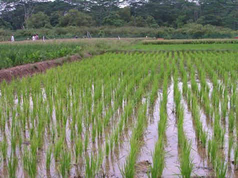
2 Alluvial Soils


3 Shales and Sandstone Soils


4 Limestone Soils

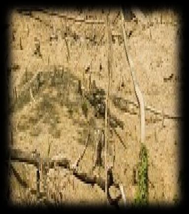
5 Chocolate Hills: Limestone formation


6 Andesite and Basalt Soils

7 Mountain Soils

8 SOURCE:

9
10
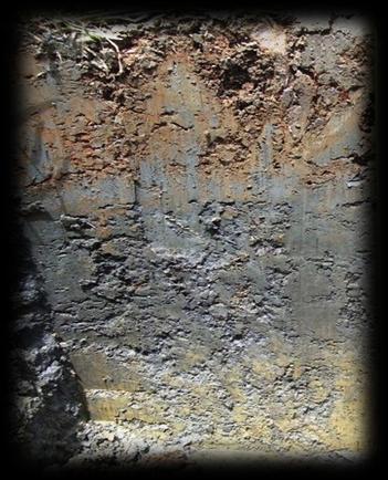
11 The distribution of soils in the Philippines is largely controlled by parent material, relief, and vegetation. In general, Philippine soils are younger than the tropical soils in mainland Asia, Central and South America, and Africa. This is because most Philippine islands are geologically young since they were the result of, just like much of Southeast Asia, recent Cenozoic tectonic events and have emerged from the sea recently (Hall, 2002). Philippine soils maybe grouped based on geomorphology and for practical purposes, into: soils in lowland areas, soils in young and unstable uplands, and soils in old and stable uplands. SOURCE:
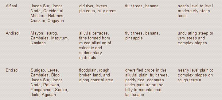
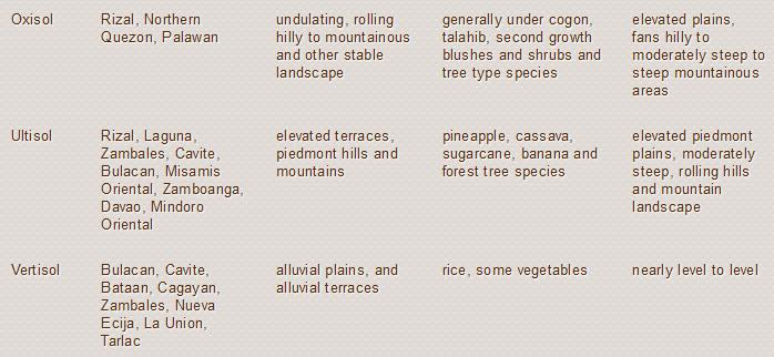
12 Arenosols (Entisols). These are weakly developed sandy soils common in alluvial plains and coastal areas. Gleysols (Entisols, Inceptisols). These are the poorly developed wet soils in alluvial plains and marshes. They are used chiefly for lowland rice production. Together with Histosols, Gleysols are the dominant soils of wetlands. Cambisols (Inceptisols). These are weakly developed soils showing poor horizon B development. They occur in association with Gleysols although they can also be found in mountainous areas. Fluvisols (Entisols). These are the undeveloped soils commonly found along rivers. Periodic deposition of river sediments retard soil development. Vertisols (Vertisols). These are the clayey soils in lowland areas that produce large cracks on the surface during the dry season. They are very fertile and are widely used for lowland rice production Histosols. These are found in swamps, marshes, shallow lakes, and depressions. The saturated condition favors the accumulation of organic materials. Large areas are found in Leyte, Samar and Surigao. Soils in lowland areas
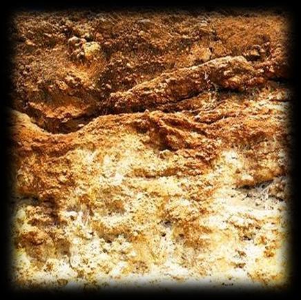
13 Leptosols (Entisols, Inceptisols). These are the shallow soils (less than 50 cm deep) in rocky areas. Soils derived from limestone in various islands Andosols (Andisols). These are the poorly developed soils on young volcanic landscapes in the mountains of Negros, Leyte, Bicol, Taal and other volcanic areas of the country. The soil is soft and very friable and appears dark due to the high organic matter content. These soils are generally favorable for crop production. Chernozems (Mollisols). These are very fertile soils due to their organic matter-rich topsoil. They can be found in limestone areas in Leyte, Bohol and other islands. Soils in young and unstable uplands Uplands are undulating as well as hilly lands ranging in elevation from near sea level to about 1000 meters. Many upland areas around the country are the result of recent volcanic activity or geologic uplift. These are young landscapes underlain by young volcanic deposits or reef limestone and thus have also poorly developed soils.
.")
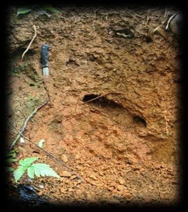
14 Ferralsols (Oxisols). These are the very deep, red, acidic and very infertile soils found in old landscapes in Palawan, Mindanao, and Samar. Acrisols and Alisols (Ultisols). These are the reddish, clayey, acidic soils widespread in hilly and mountainous areas throughout the archipelago. Luvisols (Alfisols). These are the well-developed soils with high base saturation (fertile) found in old alluvial terraces in various areas in the Philippines. Soils in old and stable uplands Old uplands were formed by volcanism or geologic uplift millions of years ago. They typically occur on the lower slopes of volcanic mountains. Soils in these areas are well-developed or highly weathered.

15
16
Lecture 7: Introduction to Soil Formation and Classification
 Lecture 7: Introduction to Soil Formation and Classification Soil Texture and Color Analysis Lab Results Soil A: Topsoil from Prof. Catalano s backyard Soil B: Soil above beach at Castlewood State Park
Physical Geology, 15/e
 Lecture Outlines Physical Geology, 15/e Plummer, Carlson & Hammersley Weathering and Soil Physical Geology 15/e, Chapter 5 Weathering, Erosion and Transportation Rocks exposed at Earth s surface are constantly
Lecture 29: Soil Formation
 Lecture 29: Soil Formation Factors Controlling Soil Formation 1. Parent material: Soil precursor 2. Climate: Temperature and precipitation 3. Biota: Native vegetation, microbes, soil animals, humans 4.
PHYSICAL GEOGRAPHY. By Brett Lucas
 PHYSICAL GEOGRAPHY By Brett Lucas SOILS Soils Soil and Regolith Soil-Forming Factors Soil Components Soil Properties Soil Chemistry Soil Profiles Pedogenic Regimes Global Distribution of Soils Distribution
Lab 7: Sedimentary Structures
 Name: Lab 7: Sedimentary Structures Sedimentary rocks account for a negligibly small fraction of Earth s mass, yet they are commonly encountered because the processes that form them are ubiquitous in the
Weathering The effects of the physical and chemical environment on the decomposition of rocks
 Weathering The effects of the physical and chemical environment on the decomposition of rocks - Igneous rocks form at high temperatures and the constituent minerals reflect the conditions of formation.
Factors of available soil water in Texas. Map Comparison project
 Factors of available soil water in Texas Map Comparison project Brandon J. Okafor 12/6/2013 Introduction Geology of Texas From mountains to coastal plains, Texas poses a great number of various physiographic
Monday, Oct Field trip A1 & A2 signups: make sure you are where you think you should be
 Monday, Oct. 4 1. Field trip A1 & A2 signups: make sure you are where you think you should be 2. 5 credit people, field trip introduction in lab today 1. If you are unable to attend THIS SATURDAY, let
Overview. Rock weathering Functions of soil Soil forming factors Soil properties
 UN-FAO A. Healthy soils are the basis for healthy food production. B. A tablespoon of normal topsoil has more microorganisms than the entire human population on Earth. C. It can take up to 1,000 years
AN OVERVIEW OF SOILS IN QUÉBEC: FORMATION, VARIABILITY AND CHALLENGES GEOLOGIC EVENTS IN SOUTHERN QUÉBEC - SOURCE OF THE PARENT MATERIAL
 SOIL CLASSIFICATION AN OVERVIEW OF SOILS IN QUÉBEC: FORMATION, VARIABILITY AND CHALLENGES Caroline. Begg, Ph.D. caroline.begg@mcgill.ca Nine Mineral Orders and one Organic Order based on the nature of
STUDENT SOIL PRESENTATIONS
 STUDENT SOIL PRESENTATIONS Soil Order (and informal name) Student Name(s) Alfisol = deciduous forest soil Andisol = formed on volcanic ash Aridisol = desert soil Entisol = alluvium soil Gelisol = tundra
 3 CL PRELIMINARY SOIL MAP OF THE KINANGOP AREA Appendix 2 to Report No.. 34*. "Soils of the.kinangop Area" O" LEGEND LPbP AD M MOUNTAINS AND MAJOR.SCARPS (slopes over 30%) MV Soil.s developed on undifferentiated
CANADA S LANDFORM REGIONS
 CANADA S LANDFORM REGIONS Canada s Regions Canada is divided into Eight major regions. A Region is an area that is defined on the basis of the presence or absence of certain characteristics: Age of rock
PALEOGEOGRAPHY of NYS. Definitions GEOLOGIC PROCESSES. Faulting. Folding 9/6/2012. TOPOGRAPHIC RELIEF MAP of NYS GRADATIONAL TECTONIC
 TOPOGRAPHIC RELIEF MAP of NYS PALEOGEOGRAPHY of NYS Prof. Anthony Grande AFG 2012 Definitions GEOLOGIC PROCESSES Geography: study of people living on the surface of the earth. Geology: the scientific study
GEOL Lab #11 Information (Guidelines for Student Soil Presentations on April 8)
") GEOL 333 - Lab #11 Information (Guidelines for Student Soil Presentations on April 8) Assignment During Lab on April 8, you will give an oral presentation about one of the 12 soil orders (categories).
GEOL 333 - Lab #11 Information (Guidelines for Student Soil Presentations on April 8) Assignment During Lab on April 8, you will give an oral presentation about one of the 12 soil orders (categories).
Continental Landscapes
 Continental Landscapes Landscape influenced by tectonics, climate & differential weathering Most landforms developed within the last 2 million years System moves toward an equilibrium Continental Landscapes
Soil. Soil in Our Environment
 Soil Soil in Our Environment What is soil? Or is it Dirt? Gold s father is dirt, yet it regards itself as noble. Yiddish Proverb Is it alive? Is it fragile? Formations of Soils How much time does it take
Landscape evolution. An Anthropic landscape is the landscape modified by humans for their activities and life
 Landforms Landscape evolution A Natural landscape is the original landscape that exists before it is acted upon by human culture. An Anthropic landscape is the landscape modified by humans for their activities
Terrain Units PALEOGEOGRAPHY: LANDFORM CREATION. Present Geology of NYS. Detailed Geologic Map of NYS
 NYS TOPOGRAPHY Why so? PALEOGEOGRAPHY: LANDFORM CREATION Prof. Anthony Grande AFG 014 Present Geology of NYS Detailed Geologic Map of NYS Generalized Geology Detailed Geology Hot links to the fold out
G470/570 Regional Landscapes of Oregon Basics of Soils and Rock Weathering
 G470/570 Regional Landscapes of Oregon Basics of Soils and Rock Weathering I. SOIL BASICS A. Soils Defined 1. Soils represent the weathered mantle of unconsolidated surficial material that covers land
LAB 6: TRINIDAD BEACH FIELD TRIP
 OBJECTIVES: LAB 6: TRINIDAD BEACH FIELD TRIP 1) to develop your powers of observation, especially of geological phenomena; 2) to identify the rocks exposed at Trinidad Beach; 3) to reconstruct some of
The future of the Lowland Belizean Savannas?.
 The future of the Lowland Belizean Savannas?. Using cluster analysis to explore multivariate spatial patterns in savanna soils PETER FURLEY & SARAH BEADLE UK Belize association 15 th November 2014 Outline
2. PHYSICAL FEATURES OF INDIA
 2. PHYSICAL FEATURES OF INDIA Question 1: Choose the right answer from the four alternatives given below. (i) A landmass bound by sea on three sides is referred to as (a) Coast (c) Peninsula (b) Island
LEPTOSOLS (LP) Definition of Leptosols
 Definition of Leptosols") LEPTOSOLS (LP) The Reference Soil Group of the Leptosols accommodates very shallow soils over hard rock or highly calcareous material, but also deeper soils that are extremely gravelly and/or stony. Lithosols
LEPTOSOLS (LP) The Reference Soil Group of the Leptosols accommodates very shallow soils over hard rock or highly calcareous material, but also deeper soils that are extremely gravelly and/or stony. Lithosols
Landscapes & Hydric Soils Bruce Vasilas University of Delaware
 Landscapes & Hydric Soils Bruce Vasilas University of Delaware Hydric soils are defined as soils that formed under conditions of saturation, flooding, or ponding long enough during the growing season to
Environmental Science
 Environmental Science A Study of Interrelationships Cui Jiansheng Hebei University of Science and Technology CH06 Kinds of Ecosystems and Communities Chapter Objectives After reading this chapter, you
The Lithosphere. Definition
 10/23/2017 www.komar.de The Lithosphere Modified lecture of Dr. Ben Sullivan Definition io9.com tedquarters.net Lithos = rocky; Rocky sphere Skin of an apple Two basic types crust: oceanic, continental
Earth s Layers. Earth s Surface
 CHAPTER 1 LESSON 3 Earth s Layers Earth s Surface Key Concepts What are Earth s major landforms and how do they compare? What are the major landform regions of the United States? What do you think? Read
EQ: Discuss main geographic landforms of the U.S. & Canada and examine varied landforms in relation to their lifestyles.
 EQ: Discuss main geographic landforms of the U.S. & Canada and examine varied landforms in relation to their lifestyles. Places & Terms for Discussion Appalachian Mountains Great Plains Canadian Shield
60% water. Big Bang: 14,000 millions years ago The Earth originated about 4,500 millions years ago its orbit allows water to exist in a liquid state!
 Ch2. The Sea Floor #1 Why geology of the oceans? Marine habitats are directly shaped by geological processes The form of the coastlines The depth of the water Type of bottom (muddy, sandy, rocky) #2 Geological
STUDY GUIDE FOR CONTENT MASTERY. Surface Water Movement
 Surface Water SECTION 9.1 Surface Water Movement In your textbook, read about surface water and the way in which it moves sediment. Complete each statement. 1. An excessive amount of water flowing downslope
Social Studies 9 UNIT 2 GEOGRAPHIC INFLUENCES ON IDENTITY: PLACE AND PEOPLE
 Social Studies 9 UNIT 2 GEOGRAPHIC INFLUENCES ON IDENTITY: PLACE AND PEOPLE The Structure of the Earth To understand the forces that create Canada's physical landscape we must understand the structure
Section I: Multiple Choice Select the best answer to each question. Mark your final answer on the answer sheet. (1 pt each)
") Sedimentary Rocks & Surface Processes Quest Name: Earth Science 2013 Block: Date: Section I: Multiple Choice Select the best answer to each question. Mark your final answer on the answer sheet. (1 pt each)
Sedimentary Rocks & Surface Processes Quest Name: Earth Science 2013 Block: Date: Section I: Multiple Choice Select the best answer to each question. Mark your final answer on the answer sheet. (1 pt each)
Weathering, Erosion, Deposition, and Landscape Development
 Weathering, Erosion, Deposition, and Landscape Development I. Weathering - the breakdown of rocks into smaller particles, also called sediments, by natural processes. Weathering is further divided into
Colluvial debris: Rocks that have fallen down hills. Types of Parent Material
 Weathered Rocks from the lithosphere are the parent materials for soils Nature of the parent material will greatly influence time it takes to make soil and the nature of the soil that is formed Types of
Landforms in Canada. Canada is made up of three dis;nct types of landforms: Canadian Shield Highlands Lowlands
 Canada s Landforms What is a Landform? A landform is any physical feature of the Earth s surface having a characteris;c, recognizable shape, produced by natural causes. Landforms include major features
Objectives. Introduction to Soils. Terms to know: What is soil? Study of Soils. The Soil Body 11/9/2012
 Objectives Explain what soil is and where it comes from Define a soil body List examples of the five soil-forming factors Explain how soils develop Introduction to Soils Terms to know: What is soil? Alluvial
HYDRIC SOILS. Background
 Background HYDRIC SOILS Soils consist of natural bodies that occur on a landform within a landscape and have properties that result from the integrated effects of climate and living organisms, acting on
Weathering, Soil, and Mass Movements
 Tarbuck Lutgens Weathering, Soil, and Mass Movements 5.1 Weathering Mechanical Weathering Mechanical weathering occurs when physical forces break rock into smaller and smaller pieces without changing the
Weathering and Soil Formation. Chapter 10
 Weathering and Soil Formation Chapter 10 Old and New Mountains The Appalachian Mountains appear very different from the Sierra Mountains. The Appalachians are smaller, rounded, gently sloping, and covered
Chemical Weathering and Soils
 Chemical Weathering and Soils Fresh rocks and minerals that once occupied the outermost position reached their present condition of decay through a complex of interacting physical, chemical, and biological
Module 10: Resources and Virginia Geology Topic 4 Content: Virginia Geology Notes
 Virginia is composed of a very diverse landscape that extends from the beaches and barrier islands all of the way to the highly elevated Appalachian Plateau. Geologists have discovered ancient shallow
LANDFORM REGIONS IN CANADA. Classroom Notes and Descriptions
 LANDFORM REGIONS IN CANADA Classroom Notes and Descriptions Landform Regions in Canada There are eight distinct landforms in Canada: Western Cordillera Region Interior Plains Canadian Shield Hudson Bay
What landforms make up Australia?!
 What landforms make up Australia? The tectonic forces of folding, faulting and volcanic activity have created many of Australia's major landforms. Other forces that work on the surface of Australia, and
The first step is accomplished by weathering (disintegration & decomposition) The second step is associated with the action of Soil Forming Factors
 The second step is associated with the action of Soil Forming Factors") Soil formation factors The soil formation is the process of two consecutive stages. 1. The weathering of rock (R) into Regolith 2. The formation of true soil from Regolith The evolution of true soil from
Soil formation factors The soil formation is the process of two consecutive stages. 1. The weathering of rock (R) into Regolith 2. The formation of true soil from Regolith The evolution of true soil from
Cretaceous, Dakota Formation, Terra Cotta Member South Side of I-70, Salina County, Kansas
 Cretaceous, Dakota Formation, Terra Cotta Member South Side of I-70, Salina County, Kansas Written By: Steven D.J. Baumann G-102010-1A Outcrop looking southeast Photo taken by: Steven Baumann on 10-20-2010
Portion of the Grand Canyon
 Landscapes Packet 9 Your Name Group Members Score Minutes Standard 4 Key Idea 2 Performance Indicator 2.1 Use the concepts of density and heat energy to explain observations of weather patterns, seasonal
3. The diagram below shows how scientists think some of Earth's continents were joined together in the geologic past.
 1. The map below shows the present-day locations of South America and Africa. Remains of Mesosaurus, an extinct freshwater reptile, have been found in similarly aged bedrock formed from lake sediments
What is a landform? These shapes (except for bodies of water) on the earth s surface are all examples of landforms.
 on the earth s surface are all examples of landforms.") Landforms What is a landform? These shapes (except for bodies of water) on the earth s surface are all examples of landforms. archipelago a large group of many islands. The Hawaiian Islands Lighthouse
Landforms What is a landform? These shapes (except for bodies of water) on the earth s surface are all examples of landforms. archipelago a large group of many islands. The Hawaiian Islands Lighthouse
STANDARDIZED DATABASE OF LAND EVALUATION FOR AGRICULTURAL PRODUCTION
 STANDARDIZED DATABASE OF LAND EVALUATION FOR AGRICULTURAL PRODUCTION Nguyen Xuan Hai, Pham Thi Ha Nhung, Nguyen Quoc Viet VNU University of Sciences, Nguyen Trai, Hanoi, Vietnam E-Mail: nguyenxuanhai@hus.edu.vn
mountain rivers fixed channel boundaries (bedrock banks and bed) high transport capacity low storage input output
 high transport capacity low storage input output") mountain rivers fixed channel boundaries (bedrock banks and bed) high transport capacity low storage input output strong interaction between streams & hillslopes Sediment Budgets for Mountain Rivers Little
mountain rivers fixed channel boundaries (bedrock banks and bed) high transport capacity low storage input output strong interaction between streams & hillslopes Sediment Budgets for Mountain Rivers Little
FAILURES IN THE AMAZON RIVERBANKS, IQUITOS, PERU
 FAILURES IN THE AMAZON RIVERBANKS, IQUITOS, PERU A.Carrillo-Gil University of Engineering & A.Carrillo Gil S.A.,Consulting Engineering,Lima,Peru L. Dominguez University of Engineering,Lima & The Maritime
Chapter 6, Part Colonizers arriving in North America found extremely landscapes. It looked different to region showing great.
 Social Studies 9 Unit 1 Worksheet Chapter 6, Part 1. 1. Colonizers arriving in North America found extremely landscapes. It looked different to region showing great. 2. The Earth is years old and is composed
Pedodiversity and Island Soil Geography: Testing the Driving Forces for Pedological Assemblages in Archipelagos of Different Origins
 Pedodiversity and Island Soil Geography: Testing the Driving Forces for Pedological Assemblages in Archipelagos of Different Origins William R. Effland, Ph.D. Soil Survey Division, USDA/NRCS A. Rodriguez-Rodriguez,
Geology and New England Landscapes
 Geology and New England Landscapes Jim Turenne, CPSS USDA-NRCS Warwick, RI. http://nesoil.com Why Geology? Provides the big picture of site conditions. Major part of soil formation (parent material and
Landforms. Why does the land look like it does? 1. Controlled by water 2. Controlled by the rocks
 Landforms Why does the land look like it does? 1. Controlled by water 2. Controlled by the rocks Landforms Made by Running Water Stream erosion The evolution of a river system Entrenched meanders Fluvial
Laboratory Exercise #4 Geologic Surface Processes in Dry Lands
 Page - 1 Laboratory Exercise #4 Geologic Surface Processes in Dry Lands Section A Overview of Lands with Dry Climates The definition of a dry climate is tied to an understanding of the hydrologic cycle
CHAPTER 6 & 7 VOCABULARY
 CHAPTER 6 & 7 VOCABULARY 1. Biome 2. Climate 3. Latitude 4. Altitude 5. Emergent layer 6. Epiphyte 7. Understory 8. Permafrost 9. Wetland 10.Plankton 11.Nekton 12.Benthos 13.Littoral zone 14.Benthic zone
Chapter 2. Regional Landscapes and the Hydrologic Cycle
 Chapter 2. Regional Landscapes and the Hydrologic Cycle W. Lee Daniels Department of Crop and Soil Environmental Sciences, Virginia Tech Table of Contents Introduction... 23 Soils and landscapes of the
The physical breakdown and chemical alteration of rocks and minerals at or near Earth s surface.
 The physical breakdown and chemical alteration of rocks and minerals at or near Earth s surface. The material that is chemically and mechanically weathered to yield sediment and soil. Regolith consisting
Soil Types. Detailed
 Soil Science and Soil Physics Lecture 12 Soil Types Detailed Taxonomy according to FAO/UNESCO Basic soil horizons O A E B C R Plant litter at various levels of decomposition and humus - Organic matter)
PHYSICAL FEATURES OF EUROPE. Europe Unit
 PHYSICAL FEATURES OF EUROPE Europe Unit PENINSULA OF PENINSULAS Europe is a large peninsula that consists of many smaller peninsulas Most places in Europe are no more than 300 miles from an ocean or sea
SCI-5 KES 5.7 Geology Post-test Exam not valid for Paper Pencil Test Sessions
 SCI-5 KES 5.7 Geology Post-test Exam not valid for Paper Pencil Test Sessions [Exam ID:1D5NLH 1 Earth's crust is made of plates that move slowly. This movement changes the appearance of the Earth's crust
Geosphere Final Exam Study Guide
 Geosphere Final Exam Study Guide Chapter 1 Intro to Earth Systems 1. Name and describe Earth s 4 major spheres Geosphere-- nonliving, mostly solid rock divided into crust, mantle, and core Atmosphere a
WHAT IS THE EARTH MADE OF? LITHOSPHERE AND HYDROSPHERE
 UNIT 8 WHAT IS THE EARTH MADE OF? LITHOSPHERE AND HYDROSPHERE TABLE OF CONTENTS 1 THE STRUCTURE OF THE EARTH... 2 2 THE FORMATION OF THE RELIEF: INTERNAL AND EXTERNAL FORCES.... 2 2.1 Internal forces:
Ms. A. Mormando's Class *
 8 th Grade Science Essential Standard: 8.E.1.1 Explain the structure of the hydrosphere including: Water distribution on Earth; Local river basin and water availability Stream - A stream is a body of water
6.E E Rock Cycle/Weathering/Soil
 Name: Date: 1. A lake is surrounded by hills covered with trees and shrubs. Which statement correctly describes how a change to the plants in this area will affect this environment? A. Adding plants to
Circle the correct (best) terms inside the brackets:
 terms inside the brackets:") 1 Circle the correct (best) terms inside the brackets: 1) Soils are [consolidated / unconsolidated] [natural / artificial] bodies at the earth s surface. Soils contain mineral and organic material, which
1 Circle the correct (best) terms inside the brackets: 1) Soils are [consolidated / unconsolidated] [natural / artificial] bodies at the earth s surface. Soils contain mineral and organic material, which
Earth Science. STREAM DRAINAGE PATTERNS (start by reading the first page of these notes!)
") Name _ Earth Science STREAM DRAINAGE PATTERNS (start by reading the first page of these notes!) WHAT IS A DRAINAGE PATTERN? Streams seek the lowest path as they move downhill, and they tend to erode their
Name _ Earth Science STREAM DRAINAGE PATTERNS (start by reading the first page of these notes!) WHAT IS A DRAINAGE PATTERN? Streams seek the lowest path as they move downhill, and they tend to erode their
Name. 4. The diagram below shows a soil profile formed in an area of granite bedrock. Four different soil horizons, A, B, C, and D, are shown.
 Name 1. In the cross section of the hill shown below, which rock units are probably most resistant to weathering? 4. The diagram below shows a soil profile formed in an area of granite bedrock. Four different
Movement of the Earth s Crust: Formation of: Mountain s Plateau's and Dome s
 Movement of the Earth s Crust: Formation of: Mountain s Plateau's and Dome s References Information taken from several places including Prentice Hall Earth Science: @ http://www.eram.k12.ny.us/education/components/docmgr/default.php?sectiondetaili
TOPOGRAPHIC RELIEF MAP of NYS. LANDFORMS of NYS. Landforms. Creation of NYS Landforms 9/22/2011
 TOPOGRAPHIC RELIEF MAP of NYS LANDFORMS of NYS Prof. Anthony Grande AFG 2011 Landforms The basis of present-day landforms (surface features) is the bedrock geology that has been worked on by the forces
Writing Earth s History
 Earths History Writing Earth s History How is Earths History like writing in your Journal? Everyday, something happens and, with a pen, it is written down in the pages of your journal. As you continue,
Monument Valley, Utah. What weathering processes contributed to the development of these remarkable rock formations? Weathering Mechanisms
 Monument Valley, Utah. What weathering processes contributed to the development of these remarkable rock formations? Weathering Includes Physical, Chemical, Biological processes WEATHERING CHAPTER 7 Weathering
Science and Health EFFECT OF EROSION ON THE CONDITION OF SOIL AND LAND SHAPE
 4 Module 51 Science and Health EFFECT OF EROSION ON THE CONDITION OF SOIL AND LAND SHAPE A DepEd-BEAM Distance Learning Program supported by the Australian Agency for International Development To the Learner
Depositional Environments. Depositional Environments
 Depositional Environments Geographic area in which sediment is deposited Characterized by a combination of geological process & environmental conditions Depositional Environments Geological processes:
Result of Field Geological Survey and Ground Truth for the Analysis Date: 2007/7/5 Location (UTM) Elev Geological Unit Point No. NT-02 VSW Index 260,7
 Elev Geological Unit Point No. NT-02 VSW Index 260,7") Date: Point No. 2007/7/5 NT-01 Result of Field Geological Survey and Ground Truth for the Analysis Location (UTM) Topography of granite hill in flat land Lithology: Medium grained hornblende granite. Topography:
Date: Point No. 2007/7/5 NT-01 Result of Field Geological Survey and Ground Truth for the Analysis Location (UTM) Topography of granite hill in flat land Lithology: Medium grained hornblende granite. Topography:
Grade 9 Social Studies Canadian Identity. Chapter 2 Review Canada s Physical Landscape
 Grade 9 Social Studies Canadian Identity Chapter 2 Review Canada s Physical Landscape Name: Unit 1: Empowerment Terms (notes or textbook) 1. Core 2. Crust 3. Mantle 4. Magma 5. Continental drift 6. Plate
Plate Tectonics Tutoiral. Questions. Teacher: Mrs. Zimmerman. Plate Tectonics and Mountains Practice Test
 Teacher: Mrs. Zimmerman Print Close Plate Tectonics and Mountains Practice Test Plate Tectonics Tutoiral URL: http://www.hartrao.ac.za/geodesy/tectonics.html Questions 1. Fossils of organisms that lived
Geologic History. Earth is very, very old
 Geologic History Earth is very, very old Earth s History The history of Earth and the ages of rocks can be investigated and understood by studying rocks and fossils. Evidence of ancient, often extinct
Weathering, Erosion and Deposition
 Weathering, Erosion and Deposition Shaping the Earth s Surface Weathering the process of breaking down rocks into smaller fragments Erosion the transport of rock fragments from one location to another
Introduction to Soil Science and Wetlands Kids at Wilderness Camp
 Introduction to Soil Science and Wetlands Kids at Wilderness Camp Presented by: Mr. Brian Oram, PG, PASEO B.F. Environmental Consultants http://www.bfenvironmental.com and Keystone Clean Water Team http://www.pacleanwater.org
UNIT 2 WARM UP. List the OCEANS. Bonus: Name the Largest LAKE on Earth
 UNIT 2 WARM UP List the OCEANS Bonus: Name the Largest LAKE on Earth Land Forms Land Mountain Hill Cliff Butte Mesa Plateau Cave Volcano Desert Plains Prairie Steppe Marsh Swamp Tundra Glacier Continent
Marine Science and Oceanography
 Marine Science and Oceanography Marine geology- study of the ocean floor Physical oceanography- study of waves, currents, and tides Marine biology study of nature and distribution of marine organisms Chemical
Chapter 1 Section 2. Land, Water, and Climate
 Chapter 1 Section 2 Land, Water, and Climate Vocabulary 1. Landforms- natural features of the Earth s land surface 2. Elevation- height above sea level 3. Relief- changes in height 4. Core- most inner
LANDFORMS of NYS. Landforms. Exercise 4 9/13/2012. TOPOGRAPHIC RELIEF MAP of NYS. Physiographic map of NYS and vicinity showing Surface Features
 TOPOGRAPHIC RELIEF MAP of NYS LANDFORMS of NYS Prof. Anthony Grande AFG 2012 Landforms REMINDER: The basis of present-day landforms (surface features) is the bedrock geology that has been worked on by
Appendix I SOIL RATING CHART. (Storie soil Index Rating = factor A* factor B* factor C* factor X) FACTOR A- Rating on character of Physical Profile
 FACTOR A- Rating on character of Physical Profile") Appendix I SOIL RATING CHART (Storie soil Index Rating = factor A* factor B* factor C* factor X) FACTOR A- Rating on character of Physical Profile Sr. No Particulars Percentage I Soil on recent alluvial
Appendix I SOIL RATING CHART (Storie soil Index Rating = factor A* factor B* factor C* factor X) FACTOR A- Rating on character of Physical Profile Sr. No Particulars Percentage I Soil on recent alluvial
PHYSICAL GEOGRAPHY: An overview. Definitions. Faulting. Folding GEOLOGIC PROCESSES 9/17/2013 TOPOGRAPHIC RELIEF
 TOPOGRAPHIC RELIEF PHYSICAL GEOGRAPHY: An overview Prof. Anthony Grande AFG 0913 2 Definitions GEOLOGIC PROCESSES Geography: Study of people living on the surface of the earth. Geology: the study of the
Science EOG Review: Landforms
 Mathematician Science EOG Review: Landforms Vocabulary Definition Term canyon deep, large, V- shaped valley formed by a river over millions of years of erosion; sometimes called gorges (example: Linville
THE SOILS OF ICELAND abstracts
 THE SOILS OF ICELAND abstracts Springer and OA Chapter 1. Introduction This book about the soils of Iceland takes a broad approach considering soils as a part of the environment and ecosystems resulting
Section 1: How Did Life Begin? Chapter 19: History of Life on Earth. Section 2: The Age of Earth
 Chapter 19: History of Life on Earth Section 1: How Did Life Begin? I. The Basic Chemicals of Life A. 1920s B. Earth s early oceans contained large amounts of organic molecules C. Molecules formed spontaneously
e Southeast Region of the United Statesg
 e Southeast of the United Statesg - relative location: the location of a place in relation to another place (i.e. south, near, bordering, next to) - barrier islands: located off the southeast coast of
Essentials of Geology, 11e
 Essentials of Geology, 11e and s Chapter 5 Instructor Jennifer Barson Spokane Falls Community College Geology 101 Stanley Hatfield Southwestern Illinois College Jennifer Cole Northeastern University Earth
Quaternary volcanic ash deposits in the Padang Terap District, Kedah, Peninsular Malaysia
 GEOSEA V Proceedings Vol.!, Geol. Soc. Malaysia, Bulletin 19, April 1986; pp. 533-549 Quaternary volcanic ash deposits in the Padang Terap District, Kedah, Peninsular Malaysia J. 0EBAVEYE 1, M. DE 0APPER
Landforms and Rock Structure
 Landforms and Rock Structure Rock Structure as a Landform Control Landforms of Horizontal Strata and Coastal Plains Landforms of Warped Rock Layers Landforms Developed on Other Land-Mass Types Landforms
Sediment and Sedimentary rock
 Sediment and Sedimentary rock Sediment: An accumulation of loose mineral grains, such as boulders, pebbles, sand, silt or mud, which are not cemented together. Mechanical and chemical weathering produces
PHYSICAL GEOGRAPHY General Information
 PHYSICAL GEOGRAPHY General Information By understanding the environment we can understand why one place is different or the same as another. See handout Geomorphology Geo --Land morph --Change ology --Study
Philippine Natural Hazards, Landforms and Water Forms
 Philippine Natural Hazards, Landforms and Water Forms LEARNING OBJECTIVES: identify the major natural disasters in the country; evaluate the implications of different geographical features and changes
Fukien Secondary School Monthly Vocabulary/Expression List for EMI Subjects Secondary Two. Subject: Geography
 Focus: General Specific : Section Two : Unit One 1 Landslide 2 Downslope movement 3 Rock 4 Soil 5 Gravity 6 Natural hazard 7 Rainwater 8 Friction 9 Hilly relief 10 Unstable 11 Season 12 Saturated 13 Construction
Pratice Surface Processes Test
 1. The cross section below shows the movement of wind-driven sand particles that strike a partly exposed basalt cobble located at the surface of a windy desert. Which cross section best represents the