Will Gosnold and Richard LeFever. Heat Flow and Thermal Maturity in the Williston Basin
|
|
|
- Susanna Spencer
- 6 years ago
- Views:
Transcription


1 Will Gosnold and Richard LeFever Heat Flow and Thermal Maturity in the Williston Basin
2 Outline Heat Flow Earth s Heat Flow Steady-state Heat Sources and Transient Disturbances Subsurface Temperatures Thermal Maturity Chemical Kinetics & Hydrocarbon Potential Time Temperature History New Perspective on Northern Hemisphere Heat Flow A Hypothesis to Test Implications for the Williston Basin
3 Global Heat Flow Global average heat flow: 87 mw m -2 Total surface heat flux: 44.2 x TW 83% of present surface heat flow is due to radioactive decay of U, Th, and K Earth s mantle is cooling at a rate of 36 C Ga -1 Average solar flux at TOA: 1365 W m -2 Average solar flux at the surface: 400 W m -2


4 Heat flow within ocean basins correlates with age.
5 Heat flow on the continents is linearly related to radioactive heat production in the continental crust Q HGU Q = Q 0 + AD Roy, Blackwell, and Birch, 1968 The Q vs. A relationship is recognized widely and allows definition of heat flow provinces with characteristic values of Q 0 and D Globally, Q 0 averages about 27 mw m -2 and ranges from 18 mw m -2 in the Sierra Nevada to 33 mw m -2 in the EUS D averages about 10 km and ranges from 4.5 km in the WAS to 16 km in England and Wales A does not vary significantly over time so heat flow on the continents can be considered constant.
6 Continental Heat Flow Steady-state Sources Mantle flux: averages 27 mw m -2 Crustal radioactivity from U, Th, and K: accounts for about half of surface heat flow Heat flow correlates with tectonic age. Tectonic events: 10s to 100s of mw m -2
7 Transient Signals in Continental Heat Flow Ground water flow: + or - Ground cover change: + or - Climate change: + or Characteristic thermal length αt L = Fo 1 y 10 y 100 y 1000 y 10,000 y 13 m 42 m 131 m 415 m 1,310 m α = 1x10⁻⁶ m 2 s -1 1 y 10 y 100 y 1000 y 10,000 y 9 m 28 m 87 m 275 m 868 m α = 0.44 x10⁻⁶ m 2 s -1
8 Subsurface Temperatures can be calculated if heat flow and thermal conductivity are known Fourier s law of Heat conduction q = λγ Assuming we know heat flow, temperature at depth z may be calculated by T z = n qz λ i= 1 i i


9 Geothermal Map of North America, 2004 D. Blackwell and M. Richards, Eds., Effect of radioactive heat production on temperature. Units are μw m Ground water flow Uplift and magma intrusion


10 T vs. z vs. q
11 Thermal Maturity is a measure of the degree of metamorphism of kerogen in a formation gives a rough estimate of the maximum temperature a formation has reached Two fundamental requirements: Understand chemical kinetics Understand the thermal history
12 Chemical Kinetics The basic premise of chemical E kinetics is that reaction k( T ) = rate Ae depends RT on absolute temperature and the amount of reactants Arrhenius equation: Reaction rate (k) is a function of absolute temperature(t), frequency factor (A), and activation energy (E). R is the gas constant.
13 Hydrocarbon Potential In general HC generation is too complex to describe by precise equations so Hydrocarbon Potential (M 0 )is preferred. M t = m t = k ( M m) 0 Potential (M) decreases as yield (m) increases and k is temperature dependent
14 Hydrocarbon Potential The task is to determine M 0 and A for different kerogen types across a range of activation energies (E). This is normally done by pyrolysis using a constant heating rate.
15 Kinetic Parameters for some Type II Source Rocks Source Rock E (kj mol- 1 ) A (s -1 ) Bakken Shale x10 13 Monterey Shale ,224 x10 7 Phosphoria Shale x10 10 Alum Shale x10 11 Woodford Shale x Sweeney, Gosnold, Braun and, Burnham, 1992, A chemical kinetic model for hydrocarbon generation from the Bakken Formation, Williston Basin North Dakota, UCRL-ID Hunt, Lewan, and Hennet, 1991, Modeling oil generation with TTI graphs based on the Arrhenius equation, AAPG Bull., 75(4).
16 Comparison of stratigraphic record with thermal subsidence model GHD1 (Stein and Stein, 1992) depth = t 1 2..

17 Thermal conductivity profile for the Williston Basin

18 Temperature history is dependent on heat flow and thermal properties of the basin
19

20 Is our temperature history correct? Could we have incorrect values for heat flow?
21 The normal temperature vs. depth profile in a thick clastic sedimentary section has a convex curvature due to the increase in thermal conductivity with depth caused by compaction which reduces porosity. Porosity varies with depth as Φ=Φ 0 e -cz c is a constant and z is depth Thermal conductivity, K, varies with porosity and as a function of the conductivity of the solid rock and water as K = Kr 1-Φ Kw Φ If heat flow is constant, the temperature at depth is calculated as T = T 0 + ΣΓ i z i where Γ i = q/k i

22 Shell USA Mondak Field McKenzie County Curvature in the clastic section Two is opposite possible to explanations: expectations 1. Conductivity decreases with depth 2. Surface temperature increased by 10 to 15 degrees C.
23 Empirical evidence for large magnitude postglacial warming T-z measurements in parts of Europe and North America show a systematic increase in heat flow with depth. Heat flow Depth (m) Europe North America
24 Empirical evidence for large magnitude postglacial warming Heat flow in southern hemisphere shields averages approximately 61.4 mwm -2, but heat flow in northern hemisphere shields averages 37 mwm -2. Brazil 64.8 ±? mw m -2 (86) Africa 52.3 ±? mw m -2 (145) Australia 68.1 ±? mw m -2 (157) N. America 33.1 ±? mw m -2 (315) Fennoscandia and East European Craton mw m -2 (1,352)
. Why have we not identified this signal before?")
25 Low heat flow in North America coincides with the center of the Pleistocene ice cap. (Blackwell and Richards, 2004). Why have we not identified this signal before? Conventional heat flow methodology does not sample the signal.
26 40 The effect of postglacial warming on the thermal gradient is subtle Deg C Steady-state T-z 3 Deg T-z 5 Deg T-z 10 Deg T-z 15 Deg T-z Depth (m)

27 LSQ analyses of 200 m segments of a temperature log from the Williston basin all appear linear. The geothermal gradient increases systematically with depth. The surface intercept on the temperature scale decreases systematically with depth. Does the change in surface temperature show the amount of warming that has occurred at the surface? If so, the minimum warming has been at least 12 K.

28 Three T-z profiles from the Williston basin exhibit an increase in heat flow with depth. The synthetic T-z shows an expected profile for constant heat flow with the effects of compaction on thermal conductivity. The 15 degree signal is a modeled curve for warming since 10 ka. The Glacx curve results from superposition of 3 glacial/interglacial cycles (90 ka/10) ka warming signal on the steady-state synthetic T-z. It appears to match closely the observed T-z profiles.


29 Percentage of q vs. depth as a result of warming 100% 90% 80% percent Q 70% 60% 50% 40% 30% 15 deg 10 deg 5 deg 3 deg 96 percent of heat flow determinations in North America were made in boreholes less than 2000 m deep Depth (m)


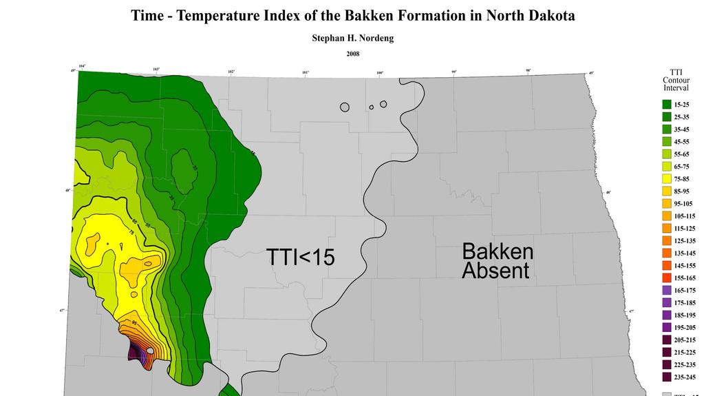
30 Higher paleo heat flow would imply the area of mature Bakken is greater than thought. Oil generation zone

31 %Ro with q = 40 mw m-2

32 %Ro with q = 60 mw m-2
33 How can the hypothesis be tested? Determine heat flow at multiple points in the borehole. Core drill the clastic section for thermal conductivity measurements. Let the borehole recover thermal equilibrium to obtain an accurate temperatures.
34 Optimum sites would be in periglacial regions in rocks having minimal variability in λ.
35 Summary Estimates of source rock thermal maturity require understanding of chemical kinetics and thermal history. Determining thermal history requires a complete understanding of: Subsidence history Thermal properties Heat flow Surface temperature history
36 Summary Evidence for large magnitude post-glacial warming in northern Europe, Asia, and North America is growing. Some northern hemisphere heat flow values may require revision because they were determined from boreholes too shallow for recognition of the gradient disturbance caused by a large post-glacial warming signal. The hypothesis requires further testing with data from deep boreholes in periglacial regions. If the hypothesis passes the test, thermal maturity estimates for oil source rocks in the Williston Basin require revision.
3. Continental Heat Flow. Ge 163 4/3/15
 3. Continental Heat Flow Ge 163 4/3/15 Outline 1. Measurement of heat flow and Fourier s law 2. Overview of major variations 3. Sclater Histograms 4. Heat-flow - heat-production relationship 5. Continental
Incorporating Complex Geology in Basin Models: Example from a Forearc Basin; San Joaquin Valley, California*
 Incorporating Complex Geology in Basin Models: Example from a Forearc Basin; San Joaquin Valley, California* Lisa Alpert 1 and Carolyn Lampe 2 Search and Discovery Article #41949 (2016)** Posted November
NOTICE CONCERNING COPYRIGHT RESTRICTIONS
 NOTICE CONCERNING COPYRIGHT RESTRICTIONS This document may contain copyrighted materials. These materials have been made available for use in research, teaching, and private study, but may not be used
Evolution of Continents Chapter 20
 Evolution of Continents Chapter 20 Does not contain complete lecture notes. Mountain belts Orogenesis the processes that collectively produce a mountain belt Includes folding, thrust faulting, metamorphism,
Climate Dynamics (PCC 587): Hydrologic Cycle and Global Warming
: Hydrologic Cycle and Global Warming") Climate Dynamics (PCC 587): Hydrologic Cycle and Global Warming D A R G A N M. W. F R I E R S O N U N I V E R S I T Y O F W A S H I N G T O N, D E P A R T M E N T O F A T M O S P H E R I C S C I E N C
Climate Dynamics (PCC 587): Hydrologic Cycle and Global Warming D A R G A N M. W. F R I E R S O N U N I V E R S I T Y O F W A S H I N G T O N, D E P A R T M E N T O F A T M O S P H E R I C S C I E N C
Determination of Geothermal Gradient in the Eastern Niger Delta Sedimentary Basin from Bottom Hole Temperatures
 Journal of Earth Sciences and Geotechnical Engineering, vol. 4, no. 3, 2014, 109-114 ISSN: 1792-9040 (print), 1792-9660 (online) Scienpress Ltd, 2014 Determination of Geothermal Gradient in the Eastern
Rocks and the Rock Cycle. Banded Iron Formation
 Rocks and the Rock Cycle Banded Iron Formation Rocks Big rocks into pebbles, Pebbles into sand. I really hold a million, million Rocks here in my hand. Florence Parry Heide How do rocks change? How are
2. Heat Flow. Ge 163 3/30/15-
 2. Heat Flow Ge 163 3/30/15- Outline 1. Diffusion equation 2. Unsteady solutions 3. Measurement of surface heat flow 4. Fluctuations in surface temperature 5. Overview of heat loss 6. Measurement of heat
Before Plate Tectonics: Theory of Continental Drift
 Before Plate Tectonics: Theory of Continental Drift Predecessor to modern plate tectonics Shape and fit of the continents was the initial evidence Snider-Pelligrini (1858) Taylor (1908) Wegner (1915) Fig.
Topics: The Layers of the Earth and its Formation Sources of Heat Volcanos and Earthquakes Rock Cycle Rock Types Carbon Tax
 Topics: The Layers of the Earth and its Formation Sources of Heat Volcanos and Earthquakes Rock Cycle Rock Types Carbon Tax Essay Question on Carbon Tax 1. Drilling 2. Volcanic Activity 3. Laboratory experiments
NOTICE CONCERNING COPYRIGHT RESTRICTIONS
 NOTICE CONCERNING COPYRIGHT RESTRICTIONS This document may contain copyrighted materials. These materials have been made available for use in research, teaching, and private study, but may not be used
A) B) C) D) 4. Which diagram below best represents the pattern of magnetic orientation in the seafloor on the west (left) side of the ocean ridge?
 B) C) D) 4. Which diagram below best represents the pattern of magnetic orientation in the seafloor on the west (left) side of the ocean ridge?") 1. Crustal formation, which may cause the widening of an ocean, is most likely occurring at the boundary between the A) African Plate and the Eurasian Plate B) Pacific Plate and the Philippine Plate C)
1. Crustal formation, which may cause the widening of an ocean, is most likely occurring at the boundary between the A) African Plate and the Eurasian Plate B) Pacific Plate and the Philippine Plate C)
Plate Tectonics. Why Continents and Ocean Basins Exist
 Plate Tectonics Plate Tectonics Why Continents and Ocean Basins Exist Topics Density Structure of Earth Isostasy Sea-Floor Spreading Mechanical Structure of Earth Driving Mechanism of Plate Tectonics Lithospheric
Selected Features of Giant Fields, Using Maps and Histograms By M.K. Horn 1
 Selected Features of Giant Fields, Using Maps and Histograms By M.K. Horn 1 Search and Discovery Article #10068 (2004) 1 M.K. Horn & Associates, Tulsa, OK (m.horn@sbcglobal.net) Introduction AAPG Memoir
12. The diagram below shows the collision of an oceanic plate and a continental plate.
 Review 1. Base your answer to the following question on the cross section below, which shows the boundary between two lithospheric plates. Point X is a location in the continental lithosphere. The depth
Tectonic heat flow modelling for basin maturation: method and applications
 Tectonic heat flow modelling for basin maturation: method and applications J.D. van Wees 1,2, R. Abdul-Fattah 1, D. Bonte 1,2, H. Kombrink 1, H. Verweij 1, F. van Bergen, P. David F. Beekman 2, S. Cloetingh
Neogene Uplift of The Barents Sea
 Neogene Uplift of The Barents Sea W. Fjeldskaar A. Amantov Tectonor/UiS, Stavanger, Norway FORCE seminar April 4, 2013 The project (2010-2012) Funding companies Flat Objective The objective of the work
11 Plate Tectonics Abridged. Japan GEOG /10/2013. Instructor: Pesses 1. Part III Earth s Changing Landscapes
 11 Plate Tectonics Abridged Part III Earth s Changing Landscapes Geography 101 Physical Geography: Earth s Surface Landscapes M. Pesses, Antelope Valley College Japan Pictures provided by Prof. Lori Dengler,
Petrology. Petrology: the study of rocks, especially aspects such as physical, chemical, spatial and chronoligic. Associated fields include:
 Petrology Petrology: the study of rocks, especially aspects such as physical, chemical, spatial and chronoligic. Associated fields include: Petrography: study of description and classification of rocks
UK data for geothermal resource assessments
 UK data for geothermal resource assessments Jon Busby UK data for geothermal resource assessments Outline 1. Data availability 2. Sub-surface temperatures 3. The EGS resource 4. Deep saline aquifers Publicly
Name Date Class. Directions: Use the diagram below to answer question Florida Progress Monitoring and Benchmark Assessments
 b e n c h m a r k t e s t : e a r t h a n d s p a c e s c i e n c e Multiple Choice 1. Geologists obtain indirect evidence about Earth s interior by A measuring pressure differences at Earth s surface.
Kinetics of the Opal-A to Opal-CT Phase Transition in Low- and High-TOC Siliceous Shale Source Rocks*
 Kinetics of the Opal-A to Opal-CT Phase Transition in Low- and High-TOC Siliceous Shale Source Rocks* Danica Dralus 1, Michael D. Lewan 2, and Kenneth Peters 3 Search and Discovery Article #41708 (2015)**
CH2356 Energy Engineering Geothermal Energy. Dr. M. Subramanian
 CH2356 Energy Engineering Geothermal Energy Dr. M. Subramanian Associate Professor Department of Chemical Engineering Sri Sivasubramaniya Nadar College of Engineering Kalavakkam 603 110, Kanchipuram(Dist)
Drifting Continents and Spreading Seas. The Road To Plate Tectonics
 Drifting Continents and Spreading Seas The Road To Plate Tectonics Alfred Wegener and the Continental Drift hypothesis: Up until the early 1900s, long-held tradition in the earth sciences stated that continents
Petrology. Petrology: the study of rocks, especially aspects such as physical, chemical, spatial and chronoligic. Classification:
 Petrology Petrology: the study of rocks, especially aspects such as physical, chemical, spatial and chronoligic. Associated fields include: Petrography: study of description and classification of rocks
Prentice Hall EARTH SCIENCE
 Prentice Hall EARTH SCIENCE Tarbuck Lutgens Chapter 9 Plate Tectonics 9.1 Continental Drift An Idea Before Its Time Wegener s continental drift hypothesis stated that the continents had once been joined
Prentice Hall EARTH SCIENCE
 Prentice Hall EARTH SCIENCE Tarbuck Lutgens Chapter 9 Plate Tectonics 9.1 Continental Drift An Idea Before Its Time Wegener s continental drift hypothesis stated that the continents had once been joined
GEOL5690 Class notes #2: Passive Margins & Thermal Subsidence
 GEOL569 Class notes #2: Passive Margins & Thermal Subsidence Reference: Turcotte and Schubert, sec. 4-15, 4-16, 4-23, 4-25, last is most relevant, earlier readings provide background. [Alternative: Stüwe,
Backstripping sediments progressively through geological time.
 Backstripping sediments progressively through geological time. The purpose of backstripping is to use the stratigraphic record to quantitatively estimate the depth that basement would be in the absence
Mountain Building. Mountain Building
 Mountain Building Mountain building has occurred during the recent geologic past American Cordillera the western margin of the Americas from Cape Horn to Alaska Includes the Andes and Rocky Mountains Alpine
Copyright McGraw-Hill Education. All rights reserved. No reproduction or distribution without the prior written consent of McGraw-Hill Education
 Copyright McGraw-Hill Education. All rights reserved. No reproduction or distribution without the prior written consent of McGraw-Hill Education Tibetan Plateau and Himalaya -southern Asia 11.00.a VE 10X
EVALUATING HEAT FLOW AS A TOOL FOR ASSESSING GEOTHERMAL RESOURCES
 PROCEEDINGS, Thirtieth Workshop on Geothermal Reservoir Engineering Stanford University, Stanford, California, January 31-February 2, 2005 SGP-TR-176 EVALUATING HEAT FLOW AS A TOOL FOR ASSESSING GEOTHERMAL
Recap and Integrated Rock Mechanics and Natural Fracture Study on the Bakken Formation, Williston Basin Abstract Figure 1:
 Recap and Integrated Rock Mechanics and Natural Fracture Study on the Bakken Formation, Williston Basin Cosima Theloy, Department of Geology & Geological Engineering Abstract The late Devonian to early
Chapter 1 Section 2. Land, Water, and Climate
 Chapter 1 Section 2 Land, Water, and Climate Vocabulary 1. Landforms- natural features of the Earth s land surface 2. Elevation- height above sea level 3. Relief- changes in height 4. Core- most inner
Earth s History. The principle of states that geologic processes that happened in the past can be explained by current geologic processes.
 Earth s History Date: Been There, Done That What is the principle of uniformitarianism? The principle of states that geologic processes that happened in the past can be explained by current geologic processes.
Lecture #13 notes, Geology 3950 Spring 2006: CR Stern Magnetic reversals (text pages th edition and in the 5 th edition)
") Lecture #13 notes, Geology 3950 Spring 2006: CR Stern Magnetic reversals (text pages 35-37 4 th edition and 53-55 in the 5 th edition) The earth has a magnetic field generated by circulation of charged
Lecture #13 notes, Geology 3950 Spring 2006: CR Stern Magnetic reversals (text pages 35-37 4 th edition and 53-55 in the 5 th edition) The earth has a magnetic field generated by circulation of charged
Crustal Activity. Plate Tectonics - Plates - Lithosphere - Asthenosphere - Earth s surface consists of a major plates and some minor ones
 Name: Date: Period: Tectonics The Physical Setting: Earth Science CLASS NOTES Tectonics - s - Lithosphere - Asthenosphere - Earth s surface consists of a major plates and some minor ones The plates are
In Situ Estimates of Sub-Crustal Continental Lithospheric Heat Flow: Application to the Slave and Kaapvaal Cratons
 In Situ Estimates of Sub-Crustal Continental Lithospheric Heat Flow: Application to the Slave and Kaapvaal Cratons Paul Morgan 1,2 and Suzanne Y. O Reilly 2 1 Department of Geology, Box 4099, Northern
Geotherms. Reading: Fowler Ch 7. Equilibrium geotherms One layer model
 Geotherms Reading: Fowler Ch 7 Equilibrium geotherms One layer model (a) Standard model: k = 2.5 W m -1 C -1 A = 1.25 x 10⁻⁶ W m -3 Q moho = 21 x 10-3 W m -2 shallow T-gradient: 30 C km -1 deep T-gradient:
Maturity Modeling of Gomin and South Gomin fields Southern Pattani Basin, Gulf of Thailand
 Maturity Modeling of Gomin and South Gomin fields Southern Pattani Basin, Gulf of Thailand Patinya Jaithan Petroleum Geoscience Program, Department of Geology, Faculty of Science, Chulalongkorn University,
An Assessment of Heat Flow and Enhanced Geothermal System Resources in Minnesota
 GRC Transactions, Vol. 35, 2011 An Assessment of Heat Flow and Enhanced Geothermal System Resources in Minnesota Robert Klenner 1, Will Gosnold 1, John Heine 2, Mark Severson 2 and Steve Hauck 2 1 University
Earth Movement and Resultant Landforms
 Earth Movement and Resultant Landforms Structure of the Earth Lithosphere : earth s crust Asthenosphere : upper mantle zone where material is near its melting point & acts almost like liquid (appprox.
Earth Science, (Tarbuck/Lutgens) Chapter 10: Mountain Building
 Chapter 10: Mountain Building") Earth Science, (Tarbuck/Lutgens) Chapter 10: Mountain Building 1) A(n) fault has little or no vertical movements of the two blocks. A) stick slip B) oblique slip C) strike slip D) dip slip 2) In a(n) fault,
Earth Science, (Tarbuck/Lutgens) Chapter 10: Mountain Building 1) A(n) fault has little or no vertical movements of the two blocks. A) stick slip B) oblique slip C) strike slip D) dip slip 2) In a(n) fault,
Lecture 2: Causes of metamorphism
 Lecture 2: Causes of metamorphism Metamorphism refers to a suite of processes that change the mineralogy, composition and texture of pre-existing materials this is a broad definition and certain industrial
b. atomic mass H What is the density of an object with a volume of 15cm 3 and a mass of 45g?
 Name Period Date Earth Science Midterm Review 2015-2016 Quarter 1 Review Assign #1 Basic Chemistry An atom is a basic chemical building block of matter. An atom consists of protons, neutrons, and electrons.
Earth Systems Science Chapter 7. Earth Systems Science Chapter 7 11/11/2010. Seismology: study of earthquakes and related phenomena
 Earth Systems Science Chapter 7 I. Structure of the Earth II. Plate Tectonics The solid part of the earth system includes processes, just like the atmosphere and oceans. However, the time scales for processes
Orphan Basin, Offshore Newfoundland: New seismic data and hydrocarbon plays for a dormant Frontier Basin
 Orphan Basin, Offshore Newfoundland: New seismic data and hydrocarbon plays for a dormant Frontier Basin Jerry Smee* G&G Exploration Consulting, 301 400-3rd Avenue SW, Calgary, AB, T2P 4H2 Sam Nader, Paul
Units. specified to be meaningful. between different scales. - All physical quantities must have their units. - We will always used SI units.
 Units - All physical quantities must have their units specified to be meaningful. - We will always used SI units. - We must be comfortable with conversions between different scales. 2 General View of the
UNIT 11 PLATE TECTONICS
 UNIT 11 PLATE TECTONICS A. ALFRED WEGENER 1. Continental drift hypothesis Single supercontinent called Pangaea 200 million years ago Pangaea (all land) began to break up and started drifting to their present
TAKE HOME EXAM 8R - Geology
 Name Period Date TAKE HOME EXAM 8R - Geology PART 1 - Multiple Choice 1. A volcanic cone made up of alternating layers of lava and rock particles is a cone. a. cinder b. lava c. shield d. composite 2.
Unit 11: Plate Tectonics
 Unit 11: Plate Tectonics A. Alfred Wegner 1. Continental drift hypothesis a. single supercontinent called Pangaea b. 200 million years ago Pangaea (all land) began to break up and started drifting to their
Phanerozoic (last 0.54 by) Tectonics Climate Life
 Tectonics Climate Life") Phanerozoic (last 0.54 by) Tectonics Climate Life Tools for Locating Past Continent Positions Fossils depending on climate Alignment of geological features Geometrical fit of continental margins Similarity
Phanerozoic (last 0.54 by) Tectonics Climate Life Tools for Locating Past Continent Positions Fossils depending on climate Alignment of geological features Geometrical fit of continental margins Similarity
Geosciences Career Pathways (Including Alternative Energy)
") Geosciences Career Pathways (Including Alternative Energy) Shale Carbonates Clastics Unconventionals Geology Characterization and Production Properties of Gas Shales Geomechanics in International Shale
Geosciences Career Pathways (Including Alternative Energy) Shale Carbonates Clastics Unconventionals Geology Characterization and Production Properties of Gas Shales Geomechanics in International Shale
Introduction To Plate Tectonics Evolution. (Continents, Ocean Basins, Mountains and Continental Margins)
") Introduction To Plate Tectonics Evolution (Continents, Ocean Basins, Mountains and Continental Margins) Geo 386 (Arabian Shield Course) Dr. Bassam A. A. Abuamarah Mohanna G E O 3 8 6 A R A B I A N G E
Introduction To Plate Tectonics Evolution (Continents, Ocean Basins, Mountains and Continental Margins) Geo 386 (Arabian Shield Course) Dr. Bassam A. A. Abuamarah Mohanna G E O 3 8 6 A R A B I A N G E
12/3/2014. Plate Tectonics: A Scientific Revolution Unfolds Earth Science, 13e Chapter 7. Continental drift: an idea before its time
 Plate Tectonics: A Scientific Revolution Unfolds Earth Science, 13e Chapter 7 Stanley C. Hatfield Southwestern Illinois College Continental drift: an idea before its time Alfred Wegener First proposed
Marine Heat Flow Measurements Information Brochure
 Marine Heat Flow Measurements Information Brochure 5 1 2 3 4 5 5 6 7 8 5 9 10 11 12 13 14 5 15 16 17 18 19 20 21 5 22 0 200 400 600 800 1000 1200 1400 1600 Time (s) What is the use of heat flow measurements?
Global Tectonics. Kearey, Philip. Table of Contents ISBN-13: Historical perspective. 2. The interior of the Earth.
 Global Tectonics Kearey, Philip ISBN-13: 9781405107778 Table of Contents Preface. Acknowledgments. 1. Historical perspective. 1.1 Continental drift. 1.2 Sea floor spreading and the birth of plate tectonics.
Today we will discuss places mobility Natural disasters lead to California s beauty Aesthenosphere
 Agenda 2. Geologic History Today we will discuss What Physical Geography is Brief geologic history of California Geography 106 California Geography M. Pesses Antelope Valley College Physical Geographers
ENIGMA: something that is mysterious, puzzling, or difficult to understand.
 Lecture 12. Attempts to solve the Eccentricity Enigma ENIGMA: something that is mysterious, puzzling, or difficult to understand. Milankovitch forcing glacier responses pre-900,000 yr BP glacier responses
Composition of the earth, Geologic Time, and Plate Tectonics
 Composition of the earth, Geologic Time, and Plate Tectonics Layers of the earth Chemical vs. Mechanical Chemical : Mechanical: 1) Core: Ni and Fe 2) Mantle: Mostly Peridotite 3) Crust: Many different
Answers: Internal Processes and Structures (Isostasy)
") Answers: Internal Processes and Structures (Isostasy) 1. Analyse the adjustment of the crust to changes in loads associated with volcanism, mountain building, erosion, and glaciation by using the concept
Answers: Internal Processes and Structures (Isostasy) 1. Analyse the adjustment of the crust to changes in loads associated with volcanism, mountain building, erosion, and glaciation by using the concept
EARTH S ENERGY SOURCES
 EARTH S ENERGY SOURCES The geological processes that shape the Earth s surface are powered by two major sources of energy; geothermal heat from the Earth s interior and external energy from the sun. The
Rock Cycle. Draw the Rock cycle on your remediation page OR use a sheet of notebook paper and staple
 Earth Science Test 8.ESS2.3) Describe the relationship between the processes and forces that create igneous, sedimentary, and metamorphic rocks. I can develop and use models to explain how plate movements
Geos Orogeny-mountain building: existing mountain belts are the result of Cenozoic tectonics. Cenozoic tectonism and climate.
 Geos 432-2 Cenozoic tectonism and climates; climate change Orogeny-mountain building: existing mountain belts are the result of Cenozoic tectonics Cenozoic tectonism and climate Movement of continents
Directed Reading. Section: The Theory of Plate Tectonics. to the development of plate tectonics, developed? HOW CONTINENTS MOVE
 Skills Worksheet Directed Reading Section: The Theory of Plate Tectonics 1. The theory that explains why and how continents move is called. 2. By what time period was evidence supporting continental drift,
CONTENT. A. Changes in the Crust Facts Changes Construction and Destruction. B. Continental Drift What is it? Evidence
 Name Earth Science Date Period TOPIC THE DYNAMIC EARTH CONTENT A. Changes in the Crust Facts Changes Construction and Destruction B. Continental Drift What is it? Evidence C. Theory of Plate Tectonics
Why does the Earth have volcanoes? Why is there Earthquakes?
 Why does the Earth have volcanoes? Why is there Earthquakes? Turn to your neighbor and review: How and when did the Earth form? How old are the first traces of life on Earth? Logical? * 1.5Ga (1 st multicellular
Plate Tectonics. entirely rock both and rock
 Plate Tectonics I. Tectonics A. Tectonic Forces are forces generated from within Earth causing rock to become. B. 1. The study of the origin and arrangement of Earth surface including mountain belts, continents,
The Dynamic Crust 2) 4) Which diagram represents the most probable result of these forces? 1)
 4) Which diagram represents the most probable result of these forces? 1)") 1. The diagrams below show cross sections of exposed bedrock. Which cross section shows the least evidence of crustal movement? 1) 3) 4. The diagram below represents a section of the Earth's bedrock. The
1. The diagrams below show cross sections of exposed bedrock. Which cross section shows the least evidence of crustal movement? 1) 3) 4. The diagram below represents a section of the Earth's bedrock. The
Analytical Estimation of Geotherm for Multi Layer Model from Heat Flow Equation: A Case Study of Parts of Chad Sedimentary Basin, Nigeria
 Physics International Original Research Paper Analytical Estimation of Geotherm for Multi Layer Model from Heat Flow Equation: A Case Study of Parts of Chad Sedimentary Basin, Nigeria Emujakporue Godwin
North GOM Petroleum Systems: Modeling the Burial and Thermal History, Organic Maturation, and Hydrocarbon Generation and Expulsion
 North GOM Petroleum Systems: Modeling the Burial and Thermal History, Organic Maturation, and Hydrocarbon Generation and Expulsion Roger J. Barnaby 2006 GCAGS MEETING Previous studies of northern GOM crude
Strike-Slip Faults. ! Fault motion is parallel to the strike of the fault.
 Strike-Slip Faults! Fault motion is parallel to the strike of the fault.! Usually vertical, no hanging-wall/footwall blocks.! Classified by the relative sense of motion. " Right lateral opposite block
Plate Tectonics GEOL 101 Lecture 22 How Are Mountains Built?
 Plate Tectonics GEOL 101 Lecture 22 How Are Mountains Built? The Grand Tetons, Wyoming First a Brief Review of Sea Floor Spreading Prop: Test 3 Invitations Break-Up of a Continent and Origin of an Ocean
RAYMOND SIEVER Harvard University
 E A R T H FOURTH EDITION FRANK PRESS National Academy of Sciences RAYMOND SIEVER Harvard University W. H. Freeman and Company New York Preface xiii Acknowledgments xviii PART I PROLOGUE CHAPTER 1 HISTORY
Plate Tectonics. Chapter 17. Great Idea: The entire Earth is still changing, due to the slow convection of soft, hot rocks deep within the planet.
 Plate Tectonics Chapter 17 Great Idea: The entire Earth is still changing, due to the slow convection of soft, hot rocks deep within the planet. 1 Chapter Outline The Dynamic Earth Plate Tectonics: A Unifying
STUDY GUIDE FOR MID-TERM EXAM KEY. Color, luster, cleavage, fracture, hardness, taste, smell, fluorescence, radioactivity, magnetism
 STUDY GUIDE FOR MID-TERM EXAM KEY 1. In which type of rock are fossils most likely to be found? Sedimentary Rocks 2. Which mineral is easily identified by smell? Sulfur 3. Which natural resource makes
Pyrolysis and TOC Identification of Tight Oil Sweet Spots TALK OUTLINE
 Pyrolysis and TOC Identification of Tight Oil Sweet Spots Albert Maende* and W. David Weldon, Wildcat Technologies, LLC, Humble, TX, United States. TALK OUTLINE Formation area of study Type of data, analytical
SUBSURFACE CHANGES TO EARTH. Ms. Winkle
 SUBSURFACE CHANGES TO EARTH Ms. Winkle OVERVIEW Subsurface events: occurring inside the crust and mantle Moving the lithosphere due to the convection currents in the asthenosphere Main Theories: 1912 Wegener,
Hydrogen Index as a Maturity Proxy - Some Pitfalls and How to Overcome Them*
 Hydrogen Index as a Maturity Proxy - Some Pitfalls and How to Overcome Them* Mark H. Tobey 1 and Catherine E. Campbell 2 Search and Discovery Article #41964 (2016)** Posted December 12, 2016 *Adapted from
Chapter Nineteen: Changing Earth
 Chapter Nineteen: Changing Earth 19.1 Inside Earth 19.2 Plate Tectonics 19.3 Plate Boundaries 19.4 Metamorphic Rocks 19.2 Learning Goals Discuss hypotheses which ultimately led to plate tectonics theory.
Sedimentary Basins. Gerhard Einsele. Springer-Verlag Berlin Heidelberg New York London Paris Tokyo Hong Kong Barcelona Budapest
 Gerhard Einsele Sedimentary Basins Evolution, Facies, and Sediment Budget With 269 Figures Springer-Verlag Berlin Heidelberg New York London Paris Tokyo Hong Kong Barcelona Budapest Contents Part I Types
Ch 17 Plate Tectonics Big Idea: Most geologic activity occurs at the boundaries between plates.
 Ch 17 Plate Tectonics Big Idea: Most geologic activity occurs at the boundaries between plates. 17.1 Drifting Continents 17.2 Seafloor Spreading 17.3 Plate Boundaries 17.4 Causes of Plate Motions Learning
GEOSCIENCE 105 THE DYNAMIC EARTH FIRST ONE-HOUR EXAMINATION. Tuesday, October 20, 1998 NAME STUDENT #
 GEOSCIENCE 105 THE DYNAMIC EARTH FIRST ONE-HOUR EXAMINATION Tuesday, October 20, 1998 NAME STUDENT # Instructions: 1. Answer all questions legibly. 2. Put your name and student number on this front page.
Base your answers to questions 1 through 4 on the information and diagrams below.
 Base your answers to questions 1 through 4 on the information and diagrams below. Saltwater plants of the same species were grown in soil in separate containers with 1 liter of water. All of the plants
Plate Tectonics Practice Test
 Plate Tectonics Practice Test 1. What is the main idea Alfred Wegner proposed in the Theory of Continental Drift that he published in 1915? a. The continents float on a liquid layer that allows them to
Page One. GEOL 1030 Pre test S15. Please enter your rst and last name.
 GEOL 1030 Pre test S15 Page One Please enter your rst and last name. First Name: Last Name: 1. The most common elements in the Earth's crust, in order of decreasing abundance, are: a. feldspar, quartz,
Evidence for Continental Drift and The Theory of Plate Tectonics
 Evidence for Continental Drift and The Theory of Plate Tectonics Did you know that the coal that is mined in Pennsylvania was actually formed from tropical plant life near the Equator? How did it travel
Continental Drift and Plate Tectonics
 Continental Drift and Plate Tectonics Continental Drift Wegener s continental drift hypothesis stated that the continents had once been joined to form a single supercontinent. Wegener proposed that the
Theory of Continental Drift
 Plate Tectonics Theory of Continental Drift Alfred Wegener suggested that continents had once been part of a supercontinent named Pangaea, that later broke up. The pieces moved apart over millions of years
SEDIMENTARY BASINS BASIN TYPES ACCORDING TO TECTONIC. by Prof. Dr. Abbas Mansour
 SEDIMENTARY BASINS BASIN TYPES ACCORDING TO TECTONIC by Prof. Dr. Abbas Mansour B. Convergent plate margins 10. STABLE CONTINENTAL INTERIOR BASIN E.g. Lake Eyre Basin Intracratonic (= within stable continental
Summary. The Ice Ages and Global Climate
 The Ice Ages and Global Climate Summary Earth s climate system involves the atmosphere, hydrosphere, lithosphere, and biosphere. Changes affecting it operate on time scales ranging from decades to millions
Dynamic Subsidence and Uplift of the Colorado Plateau. Supplementary Material
 GSA DATA REPOSITORY 2010177 Liu and Gurnis Dynamic Subsidence and Uplift of the Colorado Plateau Supplementary Material Lijun Liu and Michael Gurnis Seismological Laboratory California Institute of Technology
Geology: Earth and Space Science
 Geology: Earth and Space Science Essential Questions: 1. How is science different from other disciplines in the way it approaches questions? 2. How do rocks and minerals cycle through our environment and
Thermal Subsidence Tool in Move
 Thermal Subsidence Tool in Move During the formation of rift basins, the continental crust is stretched and thinned. As it thins, the asthenosphere rises to fill the space created by the thinned continental
UNIT SIX: Earth s Structure. Chapter 18 Earth s History and Rocks Chapter 19 Changing Earth Chapter 20 Earthquakes and Volcanoes
 UNIT SIX: Earth s Structure Chapter 18 Earth s History and Rocks Chapter 19 Changing Earth Chapter 20 Earthquakes and Volcanoes Chapter Nineteen: Changing Earth 19.1 Inside Earth 19.2 Plate Tectonics
Directed Reading. Section: How Mountains Form MOUNTAIN RANGES AND SYSTEMS. Skills Worksheet
 Skills Worksheet Directed Reading Section: How Mountains Form 1. How high is Mount Everest? a. about 1980 km above sea level b. more than 8 km below sea level c. more than 8 km above sea level d. more
The Rock Cycle & Plate Tectonics
 The Rock Cycle & Plate Tectonics I. The Rock Cycle 1. Rocks are the most common material on Earth. 2. They are made up of one or more minerals. A. The rock cycle explains how Earth processes change a rock
Welcome to GEO 101 Introduction to Geology
 Welcome to GEO 101 Introduction to Geology so what is Geology? not just rocks! Geology is... study of Earth and planetary bodies processes responsible for formation processes that modify all areas of geology
Setting the Stage 8/28/09 1. Review. Landscape history of WY. Climate, geology and vegetation patterns in Wyoming
 Setting the Stage Climate, geology and vegetation patterns in Wyoming 8/28/09 1 Review Vegetation ecology has its roots in phytogeography: Observation and description of PATTERNS of plant species distributions
1. In the diagram below, letters A and B represent locations near the edge of a continent.
 1. In the diagram below, letters A and B represent locations near the edge of a continent. A geologist who compares nonsedimentary rock samples from locations A and B would probably find that the samples