By Gil Brenner OLLI Geology Of New York State and NY City
|
|
|
- Cecily Jennings
- 6 years ago
- Views:
Transcription


1 By Gil Brenner OLLI 2013 Geology Of New York State and NY City

2 Before We Start-- It s All in the PLATES!


3 Geology of New York State including NYC CA. Active Margin A Passive Geologic Margin Gil Brenner 2013
4 Appalachians


5

6

7

8 Cretaceous Paleogeography 80 MYA

9 Appalachians

10 Tectonic Provinces of North America

11 Rift and Fault Block Basins Remnants of the Breakup of the Super Continent of Pangea 225 MYA CA
12

13

14 ROCKS IN PLATE TECTONIC MODEL


15

16 Grennville Orogeny Formation of Rodinia Supercontinent

17 What is a GEOLOGIC MAP???? The oldest Rocks Geologic Map of New York State
18 I billion YO Flat lying rocks Folded Appallachians

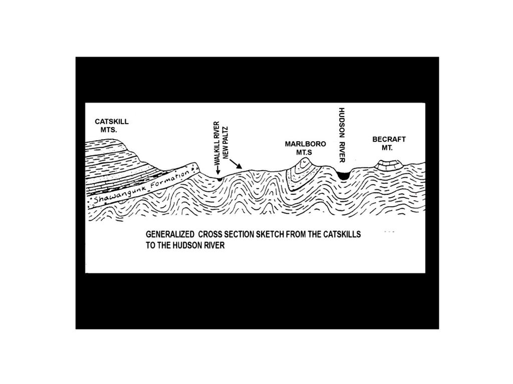
19 1 BYO MT. Marcy

20

21

22

23 Eastern NYS -- along US 84 towards Connecticut
24 W E

25 I billion YO Flat lying rocks Folded Appallachians
26 View from Hudson NY. 107 Miles off Broadway Catskills Heldeberg Escarpment Photo by Gil Brenner

27 400 MYO Silurian

28 TRENTON FALLS Heldeberg Escarpment


29

30 TRENTON FALLS, Trenton, NY

31 William J. Bennett Trenton Falls 1885


32
33 W E

34 Acadian Orogeny


35 QuickTime and a TIFF (Uncompressed) decompressor are needed to see this picture. QuickTime and a TIFF (Uncompressed) decompressor are needed to see this picture. Catskill Redbeds Near Phonecia, NY West of Kingston, NY

36 KAATERSKILL FALLS NY


37
38 I billion YO Flat lying rocks Folded Appallachians

39
40
41

42

43

44

45

46 Fordham Gneiss One Billion YO Bronx and Inwood Section


47 Manhattan Schist
48 Fault linea rift in the crust runs along underneath this street and is known as the 125th Street Fault. The fault line creates a fault valley deep enough to require the IRT Broadway 蔓 Seventh Avenue Line to become a trestle bridge between 122nd and 135th Streets. The street in the 18th century was called The Hollow Way.

49
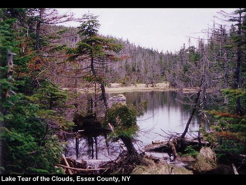
50


51

52

53
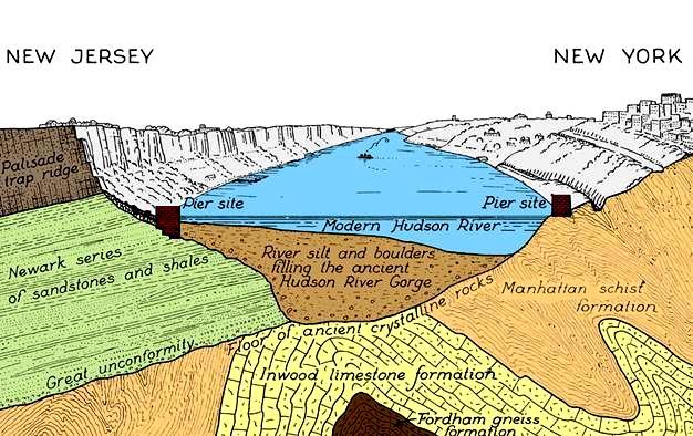
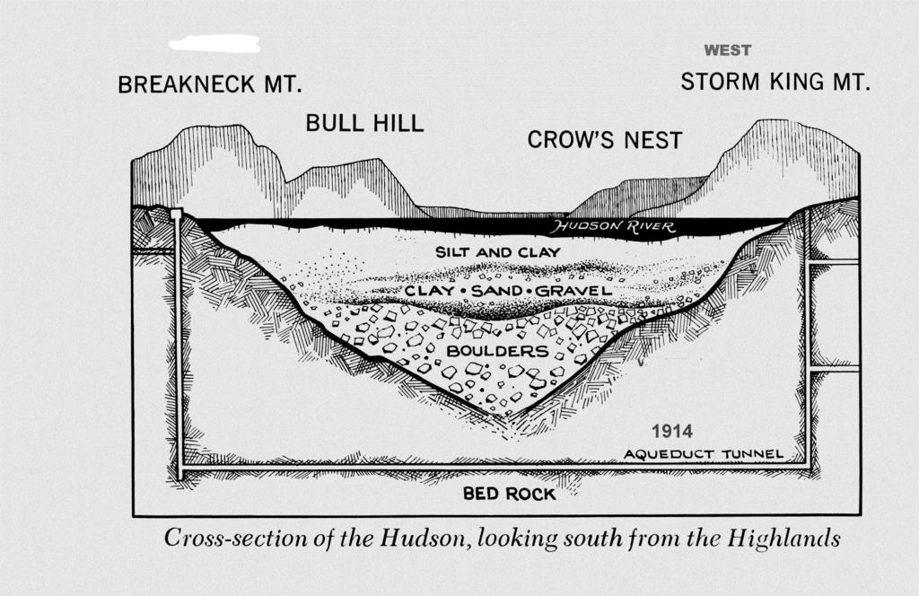
54 A Mts
55 HUDSON STARTS HERE
56

57 Mount Marcy Adirondacks

58 LAKE TEAR OF THE CLOUDS

59 The upper Hudson River flows swiftly down from its mountain sources. In the 160 miles between Lake Tear of the Clouds and the Troy Dam, the river drops more than 4,300 feet over natural rapids and man-made dams.
60
61 THE NARROWS

62 Hudson River Narrows
63 East

64 Palisades

65
66 Basalt /Diabase - Igneous Rock formed when Pangea Began to split and Atlantic Formed Palisades
67 Immigrated to Boston 1846 QuickTime and a TIFF (Uncompressed) decompressor are needed to see this picture. LOUIS AGASSIZ 1840 Swiss DISCOVERER OF THE ICE AGE


68 EVIDENCE FOR GLACIAL EPISODE LOUIS AGGAZIS 1840 ERRATICS

69 How to Become an Erratic! -in Alaska

70


71 THE ICE AGE AND


72

73 Basalt /Diabase - Igneous Rock formed when Pangea Began to split and Atlantic Formed Palisades

74 GAP MYSTERY SPARKILL

75 SPARKILL CREEK ROCKLAND COUNTY
76 QuickTime and a TIFF (Uncompressed) decompressor are needed to see this picture.

77 PERI-GLACIAL HUDSON 13MYA HUDSON RIVER SPARKILL GAP


78
79 Glacial Events Ca. 10,000 YO to Present -Warming 11,000 Younger Dryas (1200Years) 13,350 Younger Dryas(150Years), Lake Iriquois Cold eventevent 21,000 YO Laurentian Ice reaches Long Island

80 Maximum Ice Advance

81
82 Wisconsin Terminal Morraine Ice Age-the locus of the terminal moraine. Water poured in white tumult from the melting ice, carrying and sorting its freight of sands and gravels, building the outwash plain: Bensonhurst, Canarsie, the Flatlands, Coney Island.

83
84 Glacial Lake Iroquois was a prehistoric proglacial lake that existed at the end of the last ice age approximately 13,000 years ago.[1] The lake was essentially an enlargement of the present Lake Ontario that formed because the St. Lawrence River downstream from the lake was blocked by the ice sheet near the present Thousand Islands. The level of the lake was approximately 30 m (~100 ft) above the present level of Lake Ontario.[2] The lake drained to the southeast, through a channel passing near present day Rome, New York. The Rome Sand Plains has several sand ridges that geologists think were formed at this time. The channel then followed the valley of the Mohawk River to the Hudson River.[2] The lake was fed by Early Lake Erie, as well as Glacial Lake Algonquin, an early partial manifestation of Lake Huron, that drained directly to Lake Iroquois across southern Ontario, along the southern edge of the ice sheet, bypassing Early Lake Erie.


85 Glacial Lake IroquoisCa. 13,350 YA

86

87
88 As the Wisconsin Ice Sheet melted back the Hudson River cut its old path across the Highland narrows to a headward source in the Adirondacks.
89 A Mts

90 HUDSON STARTS HERE
91 But the Hudson River is still with us.

92
Terrain Units PALEOGEOGRAPHY: LANDFORM CREATION. Present Geology of NYS. Detailed Geologic Map of NYS
 NYS TOPOGRAPHY Why so? PALEOGEOGRAPHY: LANDFORM CREATION Prof. Anthony Grande AFG 014 Present Geology of NYS Detailed Geologic Map of NYS Generalized Geology Detailed Geology Hot links to the fold out
The Building of the NYC Region
 The Building of the NYC Region Definitions Fall Line marks the area where an upland region (continental bedrock) and a coastal plain meet Piedmont the plateau region of the eastern United States which
PALEOGEOGRAPHY of NYS. Definitions GEOLOGIC PROCESSES. Faulting. Folding 9/6/2012. TOPOGRAPHIC RELIEF MAP of NYS GRADATIONAL TECTONIC
 TOPOGRAPHIC RELIEF MAP of NYS PALEOGEOGRAPHY of NYS Prof. Anthony Grande AFG 2012 Definitions GEOLOGIC PROCESSES Geography: study of people living on the surface of the earth. Geology: the scientific study
TOPOGRAPHIC RELIEF MAP of NYS. LANDFORMS of NYS. Landforms. Creation of NYS Landforms 9/22/2011
 TOPOGRAPHIC RELIEF MAP of NYS LANDFORMS of NYS Prof. Anthony Grande AFG 2011 Landforms The basis of present-day landforms (surface features) is the bedrock geology that has been worked on by the forces
LANDFORMS of NYS. Landforms. Exercise 4 9/13/2012. TOPOGRAPHIC RELIEF MAP of NYS. Physiographic map of NYS and vicinity showing Surface Features
 TOPOGRAPHIC RELIEF MAP of NYS LANDFORMS of NYS Prof. Anthony Grande AFG 2012 Landforms REMINDER: The basis of present-day landforms (surface features) is the bedrock geology that has been worked on by
Name: Mid-Year Review #2 SAR
 Name: Mid-Year Review #2 SAR Base your answers to questions 1 through 3 on on the diagram below, which shows laboratory materials used for an investigation of the effects of sediment size on permeability,
Glacial Deposition and Groundwater in Dutchess County
 Glacial Deposition and Groundwater in Dutchess County Name: Period: Thousands of years ago an enormous ice sheet blanketed the Hudson Valley in what was called the Wisconsinan Glaciation. The ice reshaped
PHYSICAL GEOGRAPHY: An overview. Definitions. Faulting. Folding GEOLOGIC PROCESSES 9/17/2013 TOPOGRAPHIC RELIEF
 TOPOGRAPHIC RELIEF PHYSICAL GEOGRAPHY: An overview Prof. Anthony Grande AFG 0913 2 Definitions GEOLOGIC PROCESSES Geography: Study of people living on the surface of the earth. Geology: the study of the
discussion of North America s physical features, including its landforms and bodies of
 Chapter 7 Natural Environments of North America Chapter 7 focuses on the natural environments of North America. The chapter opens with a discussion of North America s physical features, including its landforms
Which landscape best represents the shape of the valleys occupied by glaciers? A) B) C) D)
 B) C) D)") 1. Glaciers often form parallel scratches and grooves in bedrock because glaciers A) deposit sediment in unsorted piles B) deposit rounded sand in V-shaped valleys C) continually melt and refreeze D) drag
1. Glaciers often form parallel scratches and grooves in bedrock because glaciers A) deposit sediment in unsorted piles B) deposit rounded sand in V-shaped valleys C) continually melt and refreeze D) drag
EQ: Discuss main geographic landforms of the U.S. & Canada and examine varied landforms in relation to their lifestyles.
 EQ: Discuss main geographic landforms of the U.S. & Canada and examine varied landforms in relation to their lifestyles. Places & Terms for Discussion Appalachian Mountains Great Plains Canadian Shield
C) use of nuclear power D) number of volcanic eruptions
 use of nuclear power D) number of volcanic eruptions") 3121-1 - Page 1 Name: 1) The graph below shows the change in carbon dioxide concentration in parts per million (ppm) in Earth's atmosphere from 1960 to 1990. The most likely cause of the overall change
3121-1 - Page 1 Name: 1) The graph below shows the change in carbon dioxide concentration in parts per million (ppm) in Earth's atmosphere from 1960 to 1990. The most likely cause of the overall change
Class Notes: Mapping the Earth
 Name: Date: Period: Mapping the Earth The Physical Setting: Earth Science Class Notes: Mapping the Earth I. Latitude and Longitude Map -! Latitude -! Also called These lines intersect Equator -! The North
3/5/05 Dr. Stewart 1
 I. Physiography of Appalachian Mountains A. Introduction 1. These mountains extend from NE Canada to Georgia 2. They are the remains of a deeply eroded, ancient mountain chain once larger than the Himalayans
PHYSIOGRAPHIC REGIONS OF THE LOWER 48 UNITED STATES
 PHYSIOGRAPHIC REGIONS OF THE LOWER 48 UNITED STATES LAURENTIAN UPLAND 1. Superior Upland ATLANTIC PLAIN 2. Continental Shelf (not on map) 3. Coastal Plain a. Embayed section b. Sea Island section c. Floridian
W he natural resources of Adams
 Above: Houghton Rock, Town of Adams. Following Page: "The Hole in the Rock" on Rattlesnake Mound--both remnants of rock formed by ancient seas hundreds of millions of year5 ago. (Courtesy, H.H. Bennett
Name: NYS Geology and Landscapes and some River stuff
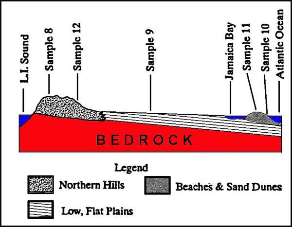
 Name: NYS Geology and Landscapes and some River stuff 1. Which types of surface bedrock are most likely found near Jamestown, New York? A) slate and marble B) quartzite and granite C) shale and sandstone
LANDFORM REGIONS IN CANADA. Classroom Notes and Descriptions
 LANDFORM REGIONS IN CANADA Classroom Notes and Descriptions Landform Regions in Canada There are eight distinct landforms in Canada: Western Cordillera Region Interior Plains Canadian Shield Hudson Bay
CARD #1 The Shape of the Land: Effects of Crustal Tilting
 CARD #1 The Shape of the Land: Effects of Crustal Tilting When we look at a birds-eye view of the Great Lakes, it is easy to assume the lakes are all at a similar elevation, but viewed in this way, we
Captain s Tryouts 2017
 Captain s Tryouts 2017 Dynamic Planet Test Written by: Araneesh Pratap (Chattahoochee High School) Name: Date: Answer all questions on the answer sheet. Point values are given next to each question or
NEW YORK S NATURAL WONDERS
 Landscapes and Drainage Patterns NEW YORK S NATURAL WONDERS New York is not one of the largest states of the United States, nor does it have any large national parks to rival Yosemite or the Grand Canyon.
Portion of the Grand Canyon
 Landscapes Packet 9 Your Name Group Members Score Minutes Standard 4 Key Idea 2 Performance Indicator 2.1 Use the concepts of density and heat energy to explain observations of weather patterns, seasonal
Beneath our Feet: The 4 Layers of the Earty by Kelly Hashway
 Beneath our Feet: The 4 Layers of the Earty by Kelly Hashway The Earth is more than a giant ball made up of dirt, rocks, and minerals. The Earth may look like a giant ball from when looking at it from
Earth s Structure and Surface
 Earth s Structure and Surface Structure of the Earth The earth is thought have originated about 4.5 billion years ago from a cloud or clouds of dust. The dust was the remains of a huge cosmic explosion
Landscape. Review Note Cards
 Landscape Review Note Cards Last Ice Age Pleistocene Epoch that occurred about 22,000 Years ago Glacier A large, long lasting mass of ice which forms on land and moves downhill because of gravity. Continental
Chapter Two. Figure 02_02. Geography of the Ocean Basins. The Sea Floor
 Chapter Two The Sea Floor Geography of the Ocean Basins Figure 02_02 The world ocean is the predominant feature on the Earth in total area. In the Northern Hemisphere, 61% of the total area is ocean. In
Earth Science Lesson Plan Quarter 3, Week 7, Day 1
 Earth Science Lesson Plan Quarter 3, Week 7, Day 1 Outcomes for Today Standard Focus: PREPARE 1. Background knowledge necessary for today s reading. Continental ice sheets increase the weight of the Earth
Name HW - Landscapes
 Name HW - Landscapes 1. New York s Tug Hill landscape region is classified as a plateau because this region has a A) high elevation with distorted bedrock B) high elevation with nearly horizontal layers
Phanerozoic (last 0.54 by) Tectonics Climate Life
 Tectonics Climate Life") Phanerozoic (last 0.54 by) Tectonics Climate Life Tools for Locating Past Continent Positions Fossils depending on climate Alignment of geological features Geometrical fit of continental margins Similarity
Phanerozoic (last 0.54 by) Tectonics Climate Life Tools for Locating Past Continent Positions Fossils depending on climate Alignment of geological features Geometrical fit of continental margins Similarity
C) Trenton limestone
 Trenton limestone") 1. Base your answer to the following question on the Earth Science Reference Tables, the core section below, and your knowledge of Earth Science. The core section shows the subsurface bedrock geology for
1. Base your answer to the following question on the Earth Science Reference Tables, the core section below, and your knowledge of Earth Science. The core section shows the subsurface bedrock geology for
Social Studies 9 UNIT 2 GEOGRAPHIC INFLUENCES ON IDENTITY: PLACE AND PEOPLE
 Social Studies 9 UNIT 2 GEOGRAPHIC INFLUENCES ON IDENTITY: PLACE AND PEOPLE The Structure of the Earth To understand the forces that create Canada's physical landscape we must understand the structure
A TRIP THROUGH VIRGINIA GEOLOGY FROM AN ENGINEER S PERSPECTIVE
 A TRIP THROUGH VIRGINIA GEOLOGY FROM AN ENGINEER S PERSPECTIVE Bob Moss, PE Principal Engineer ECS Mid Atlantic, LLC The Engineer Parent WHY IS AN UNDERSTANDING OF LOCAL GEOLOGY IMPORTANT? It provides
Refer to the map on page 173 to answer the following questions.
 Chapter 8-1 Plate Tectonics 1. Brainstorm the type of evidence that would indicate a climate change and how this evidence supports the theory of continental drift. Tropical fossils in cold regions Evidence
Module 10: Resources and Virginia Geology Topic 4 Content: Virginia Geology Notes
 Virginia is composed of a very diverse landscape that extends from the beaches and barrier islands all of the way to the highly elevated Appalachian Plateau. Geologists have discovered ancient shallow
In order to study Plate Tectonics, we must first
 TB Chapter 13 In order to study Plate Tectonics, we must first reorganize our layering system for the Earth: Old System 4 layers Crust (rigid) id) (rigid) Mantle (putty like) (semi rigid) Outer core (liquid)
1.4 Notes: Plates Converge or Scrape Past Each Other Think About Tectonic Plates Push Together at Convergent Boundaries
 1.4 Notes: Plates Converge or Scrape Past Each Other Think About If new crust is created at divergent boundaries, why does the total amount of crust on Earth stay the same? Tectonic Plates Push Together
Earth s Continents and Seafloors. GEOL100 Physical Geology Ray Rector - Instructor
 Earth s Continents and Seafloors GEOL100 Physical Geology Ray Rector - Instructor OCEAN BASINS and CONTINENTAL PLATFORMS Key Concepts I. Earth s rocky surface covered by of two types of crust Dense, thin,
Plate Tectonics: A Unifying Theory
 Plate Tectonics: A Unifying Theory What is Plate Tectonics? - 7 large tectonic plates and many smaller ones that break up the lithosphere - Plates are brittle and float on asthenosphere and glide past
3. The diagram below shows how scientists think some of Earth's continents were joined together in the geologic past.
 1. The map below shows the present-day locations of South America and Africa. Remains of Mesosaurus, an extinct freshwater reptile, have been found in similarly aged bedrock formed from lake sediments
Before 2 billion years -?? no rocks preserved
 California Geology California Geology Science Content Standards for California Public Schools 6 th Grade Focus on Earth Sciences Students know how to explain major features of California geology (including
The boulder was most likely moved to this location by A) glacial ice B) prevailing wind C) streamfiow D) volcanic action
 glacial ice B) prevailing wind C) streamfiow D) volcanic action") 1. Which rock material was most likely transported to its present location by a glacier? A) rounded sand grains found in a river delta B) rounded grains found in a sand dune C) residual soil found on a
1. Which rock material was most likely transported to its present location by a glacier? A) rounded sand grains found in a river delta B) rounded grains found in a sand dune C) residual soil found on a
Name Class Date. In the space provided, write the letter of the definition that best matches the term or phrase.
 Skills Worksheet Directed Reading Section: The Changing Continents 1. What is the result of slow movements of tectonic plates? RESHAPING EARTH S CRUST In the space provided, write the letter of the definition
24. Ocean Basins p
 24. Ocean Basins p. 350-372 Background The majority of the planet is covered by ocean- about %. So the majority of the Earth s crust is. This crust is hidden from view beneath the water so it is not as
Landforms in Canada. Canada is made up of three dis;nct types of landforms: Canadian Shield Highlands Lowlands
 Canada s Landforms What is a Landform? A landform is any physical feature of the Earth s surface having a characteris;c, recognizable shape, produced by natural causes. Landforms include major features
Copyright McGraw-Hill Education. All rights reserved. No reproduction or distribution without the prior written consent of McGraw-Hill Education
 Copyright McGraw-Hill Education. All rights reserved. No reproduction or distribution without the prior written consent of McGraw-Hill Education Tibetan Plateau and Himalaya -southern Asia 11.00.a VE 10X
Unit 5: Earth s History Practice Problems
 Name: Date: 1. Which bedrock would be most likely to contain fossils? A. Precambrian granite B. Cambrian shale C. Pleistocene basalt D. Middle-Proterozoic quartzite 6. Base your answer(s) to the following
Geology is the study of the structure and substance of the earth. The earth s physical features have been created by many geological events:
 UNIT 1 NOTES : GEOLOGY & THE EARTH S PHYSICAL STRUCTURE GEOLOGY & THE EARTH S PHYSICAL STRUCTURE Geology is the study of the structure and substance of the earth. The earth s physical features have been
General Geologic Setting and Seismicity of the FHWA Project Site in the New Madrid Seismic Zone
 General Geologic Setting and Seismicity of the FHWA Project Site in the New Madrid Seismic Zone David Hoffman University of Missouri Rolla Natural Hazards Mitigation Institute Civil, Architectural & Environmental
Chapter 7 Plate Tectonics. Plate tectonics accounts for important features of Earth s surface and major geologic events.
 Chapter 7 Plate Tectonics Plate tectonics accounts for important features of Earth s surface and major geologic events. 7-2 Alfred Wegener s Hypothesis of Continental Drift (1915) ONE single landmass
Page 1. Name:
 Name: 1) Which property would best distinguish sediment deposited by a river from sediment deposited by a glacier? thickness of sediment layers age of fossils found in the sediment mineral composition
In the space provided, write the letter of the definition that best matches the term or phrase.
 Skills Worksheet Directed Reading Section: The Changing Continents 1. What is the result of slow movements of tectonic plates? RESHAPING EARTH S CRUST In the space provided, write the letter of the definition
Ch 9.1 Notes. Objective: Be able to explain the theory of plate tectonics and be able to explain evidence that supports it.
 Ch 9.1 Notes Objective: Be able to explain the theory of plate tectonics and be able to explain evidence that supports it. Pangaea Alfred Wegener proposed that land on Earth formed a single, huge landmass.
The Sea Floor. Chapter 2
 The Sea Floor Chapter 2 Geography of the Ocean Basins World ocean is the predominant feature on the Earth in total area Northern Hemisphere = 61% of the total area is ocean. Southern Hemisphere = about
MAPPING THE EARTH HOW DO YOU FIND A LOCATION ON THE EARTH?
 MAPPING THE EARTH HOW DO YOU FIND A LOCATION ON THE EARTH? UNIT TOPICS TOPIC 1: LATITUDE & LONGITUDE TOPIC 2: FIELD MAPS TOPIC 3: TOPOGRAPHIC MAPS TOPIC 4: NYS LANDSCAPES TOPIC 1: LATITUDE & LONGITUDE
1. In the block diagram shown here, which is the oldest rock unit?
 Pre/Post GCI Name (print) 1. In the block diagram shown here, which is the oldest rock unit? 2. Referring to the same diagram as the previous question, which of the labeled rock units is the youngest?
Earth Science. STREAM DRAINAGE PATTERNS (start by reading the first page of these notes!)
") Name _ Earth Science STREAM DRAINAGE PATTERNS (start by reading the first page of these notes!) WHAT IS A DRAINAGE PATTERN? Streams seek the lowest path as they move downhill, and they tend to erode their
Name _ Earth Science STREAM DRAINAGE PATTERNS (start by reading the first page of these notes!) WHAT IS A DRAINAGE PATTERN? Streams seek the lowest path as they move downhill, and they tend to erode their
Plate Tectonics: A Scientific Revolution Unfolds
 Chapter 2 Lecture Earth: An Introduction to Physical Geology Eleventh Edition Plate Tectonics: A Scientific Revolution Unfolds Tarbuck and Lutgens From Continental Drift to Plate Tectonics Prior to the
Crustal Boundaries. As they move across the asthenosphere and form plate boundaries they interact in various ways. Convergent Transform Divergent
 Name: Date: Period: Plate Tectonics The Physical Setting: Earth Science CLASS NOTES Tectonic plates are constantly moving and interacting As they move across the asthenosphere and form plate boundaries
Chapter 6, Part Colonizers arriving in North America found extremely landscapes. It looked different to region showing great.
 Social Studies 9 Unit 1 Worksheet Chapter 6, Part 1. 1. Colonizers arriving in North America found extremely landscapes. It looked different to region showing great. 2. The Earth is years old and is composed
Section 1: How Did Life Begin? Chapter 19: History of Life on Earth. Section 2: The Age of Earth
 Chapter 19: History of Life on Earth Section 1: How Did Life Begin? I. The Basic Chemicals of Life A. 1920s B. Earth s early oceans contained large amounts of organic molecules C. Molecules formed spontaneously
4. The map below shows a meandering stream. Points A, B, C, and D represent locations along the stream bottom.
 1. Sediment is deposited as a river enters a lake because the A) velocity of the river decreases B) force of gravity decreases C) volume of water increases D) slope of the river increases 2. Which diagram
Before Plate Tectonics: Theory of Continental Drift
 Before Plate Tectonics: Theory of Continental Drift Predecessor to modern plate tectonics Shape and fit of the continents was the initial evidence Snider-Pelligrini (1858) Taylor (1908) Wegner (1915) Fig.
The United States & Canada. A Regional Study of Anglo America
 A Regional Study of Anglo America Landform Regions of the United States & Canada world leaders in agricultural and industrial production because of... VAST LANDS stretch from the Atlantic Ocean on the
Continental Drift and Plate Tectonics
 Continental Drift and Plate Tectonics As you work through the following slides of information, make sure you use the information to complete the tasks on your worksheet. By the end of the PDF, you should
CANADA S LANDFORM REGIONS
 CANADA S LANDFORM REGIONS Canada s Regions Canada is divided into Eight major regions. A Region is an area that is defined on the basis of the presence or absence of certain characteristics: Age of rock
Name. 4. The diagram below shows a soil profile formed in an area of granite bedrock. Four different soil horizons, A, B, C, and D, are shown.
 Name 1. In the cross section of the hill shown below, which rock units are probably most resistant to weathering? 4. The diagram below shows a soil profile formed in an area of granite bedrock. Four different
Question #1: What are some ways that you think the climate may have changed in the area where you live over the past million years?
 Reading 5.2 Environmental Change Think about the area where you live. You may see changes in the landscape in that area over a year. Some of those changes are weather related. Others are due to how the
Plate Tectonics CHAPTER 17
 Plate Tectonics CHAPTER 17 Layers of the Earth A. Crust- solid, 5-70 km thick Moho Two Types of Crust: Oceanic- ocean floor, more dense then because of more iron Continental-dry land (mostly silicates
Why is Sebago Lake so deep?
 Maine Geologic Facts and Localities February, 1999 Why is Sebago Lake so deep? 43 51 13.36 N, 70 33 43.98 W Text by Robert A. Johnston, Department of Agriculture, Conservation & Forestry 1 Introduction
Evidence from the Surface. Chapter 02. Continental Drift. Fossil Evidence for Pangaea. Seafloor Spreading. Seafloor Spreading 1/31/2012
 Evidence from the Surface Surface landforms Continental shelf and slope Abyssal Plane Mid-oceanic ridge Oceanic Trenches Chapter 02 Continental Drift Continental Drift - a hypothesis that the continents
Earth History Exam. The remains of an early dinosaur could be found at reference point A. A B. B C. C D. D. page 1
 Name: Date: 1. Base your answer(s) to the following question(s) on the Earth Science Reference Tables and your knowledge of Earth science. The accompanying cross section shows undisturbed sedimentary bedrock.
Weathering, Erosion, Deposition, and Landscape Development
 Weathering, Erosion, Deposition, and Landscape Development I. Weathering - the breakdown of rocks into smaller particles, also called sediments, by natural processes. Weathering is further divided into
Physiographic Provinces (West, Ch. 13)
") Geology 229 Engineering Geology Lecture 13 Physiographic Provinces (West, Ch. 13) The definition of the term Physiography Physiography (n.) The science which treats of the earth's exterior physical features,
Geology 229 Engineering Geology Lecture 13 Physiographic Provinces (West, Ch. 13) The definition of the term Physiography Physiography (n.) The science which treats of the earth's exterior physical features,
December 21, Chapter 11 mountain building E.notebook. Feb 19 8:19 AM. Feb 19 9:28 AM
 Mountains form along convergent plate boundaries. Typically (usually) if you look at a mountain range, you know that it is at a plate boundary (active continental margin) or has been some time in the past
Use of Engineering Properties to Identify Multiple Glacial Advances in New York City s Subsurface
 Use of Engineering Properties to Identify Multiple Glacial Advances in New York City s Subsurface Cheryl J. Moss, Mueser Rutledge Consulting Engineers, 14 Penn Plaza, New York, NY 10122 (cmoss@mrce.com)
Plate Tectonics GEOL 101 Lecture 22 How Are Mountains Built?
 Plate Tectonics GEOL 101 Lecture 22 How Are Mountains Built? The Grand Tetons, Wyoming First a Brief Review of Sea Floor Spreading Prop: Test 3 Invitations Break-Up of a Continent and Origin of an Ocean
Chapter. Graphics by Tasa Graphic Arts. Inc.
 Earth Chapter Plate Science 9 Tectonics Graphics by Tasa Graphic Arts. Inc. 1 I. Earth s surface is made up of lithospheric plates. A. Lithospheric plates are composed of the crust and part of the upper
You may know that you change a little every day. Maybe you grow a little or maybe you cut your hair. But did you know that the Earth changes every
 Our Changing Earth You may know that you change a little every day. Maybe you grow a little or maybe you cut your hair. But did you know that the Earth changes every day, too? Sometimes the Earth changes
The Geology of Sebago Lake State Park
 Maine Geologic Facts and Localities September, 2002 43 55 17.46 N, 70 34 13.07 W Text by Robert Johnston, Department of Agriculture, Conservation & Forestry 1 Map by Robert Johnston Introduction Sebago
Plate Tectonics 22/12/2017
 Map of the tectonic plates. Plate Tectonics In 1912 the meteorologist Alfred Wegener independently developed what he called continental drift, (expanded in his 1915 book The Origin of Continents and Oceans).
Do NOT open the test until instructed to do so.
 Raw Score: Rank: School: Team Number: Names: Boyceville Invitational, December 2, 2017 Dynamic Planet Plate Tectonics and Geographical Impacts Do NOT open the test until instructed to do so. 2011 Tohoku
Questions and Topics
 Plate Tectonics and Continental Drift Questions and Topics 1. What are the theories of Plate Tectonics and Continental Drift? 2. What is the evidence that Continents move? 3. What are the forces that
Plio-Pleistocene Geology
 UNIVERSITY OF SOUTH ALABAMA GY 112: Earth History Plio-Pleistocene Geology Instructor: Dr. Douglas W. Haywick Last Time A) Cenozoic Tectonics Western North American tectonic provinces Plateaus and canyons
CHAPTER 2 THE WAY THE EARTH WORKS: EXAMINING PLATE TECTONICS
 CHAPTER 2 THE WAY THE EARTH WORKS: EXAMINING PLATE TECTONICS Coverage of plate tectonics is required early in introductory Geology as context for the mineralogy, petrology, structure, internal processes,
mountain rivers fixed channel boundaries (bedrock banks and bed) high transport capacity low storage input output
 high transport capacity low storage input output") mountain rivers fixed channel boundaries (bedrock banks and bed) high transport capacity low storage input output strong interaction between streams & hillslopes Sediment Budgets for Mountain Rivers Little
mountain rivers fixed channel boundaries (bedrock banks and bed) high transport capacity low storage input output strong interaction between streams & hillslopes Sediment Budgets for Mountain Rivers Little
Plate Tectonic Vocabulary Chapter 10 Pages
 Name: Period: Plate Tectonic Vocabulary Chapter 10 Pages 239-260 Vocabulary Word What is this? What are some examples? What does it look like? (draw a picture or diagram) Continental drift Mid-ocean ridge
Cattaraugus Creek: A Story of Flowing Water and the Geology of the Channel It Flows Through Presentation to West Valley Citizen Task Force 4/27/16
 Cattaraugus Creek: A Story of Flowing Water and the Geology of the Channel It Flows Through Presentation to West Valley Citizen Task Force 4/27/16 Raymond C. Vaughan, Ph.D. What happens if you drop a
PHYSICAL GEOLOGY AND THE ENVIRONMENT (2 ND CANADIAN EDITION)
") Chapter 2: Plate Tectonics Chapter Summary: Plate tectonics is a theory that suggests Earth's surface is divided into several large plates that change position and size. Intense geologic activity occurs
Chapter 2: Plate Tectonics Chapter Summary: Plate tectonics is a theory that suggests Earth's surface is divided into several large plates that change position and size. Intense geologic activity occurs
Plate Tectonics. Chapter 17. Great Idea: The entire Earth is still changing, due to the slow convection of soft, hot rocks deep within the planet.
 Plate Tectonics Chapter 17 Great Idea: The entire Earth is still changing, due to the slow convection of soft, hot rocks deep within the planet. 1 Chapter Outline The Dynamic Earth Plate Tectonics: A Unifying
Full file at CHAPTER 2 The Way the Earth Works: Plate Tectonics
 CHAPTER 2 The Way the Earth Works: Plate Tectonics MULTIPLE CHOICE 1. Wegener proposed continental drift after he observed evidence from fossils, glacial deposits, and the fit of the continents that suggested
Continental Drift. & Plate Tectonics
 Continental Drift & Plate Tectonics Alfred Wegener, a German scientist, proposed the hypothesis of CONTINENTAL DRIFT, in 1912. Hypothesis stated: All Earth s continents were once a single landmass (Pangaea)
PLATE TECTONICS. Continental Drift. Continental Drift. Continental Drift. Continental Drift- Wegener s Evidence
 Continental Drift PLATE TECTONICS E.B. Taylor (1910) and Alfred Wegener (1915) published on Continental Drift. Continental Drift Wegener s evidence 1. Fit of the Continents 2. Fossil Evidence 3. Rock Type
Lecture 21: Glaciers and Paleoclimate Read: Chapter 15 Homework due Thursday Nov. 12. What we ll learn today:! Learning Objectives (LO)
") Learning Objectives (LO) Lecture 21: Glaciers and Paleoclimate Read: Chapter 15 Homework due Thursday Nov. 12 What we ll learn today:! 1. 1. Glaciers and where they occur! 2. 2. Compare depositional and
Learning Objectives (LO) Lecture 21: Glaciers and Paleoclimate Read: Chapter 15 Homework due Thursday Nov. 12 What we ll learn today:! 1. 1. Glaciers and where they occur! 2. 2. Compare depositional and
Plate Tectonics. Structure of the Earth
 Plate Tectonics Structure of the Earth The Earth can be considered as being made up of a series of concentric spheres, each made up of materials that differ in terms of composition and mechanical properties.
LATITUDE. Latitude lines run to, but are measured & The 0 of latitude that circles the earth is called the?
 LATITUDE Latitude lines run to, but are measured & The 0 of latitude that circles the earth is called the? LATITUDE 0 0 Latitude lines run east to west, but are measured north & south The 0 of latitude
Forces That Shape Earth. How do continents move? What forces can change rocks? How does plate motion affect the rock cycle?
 Forces That Shape Earth How do continents move? What forces can change rocks? How does plate motion affect the rock cycle? Plate Motion Mountain ranges are produced by plate tectonics. The theory of plate
Chapter 2 Plate Tectonics and the Ocean Floor
 Chapter 2 Plate Tectonics and the Ocean Floor Matching. Match the term or person with the appropriate phrase. You may use each answer once, more than once or not at all. 1. hydrothermal vents A. convergent
SUBSURFACE EXPLORATIONS. The Geology of the New England Area
 SUBSURFACE EXPLORATIONS The Geology of the New England Area By David Adilman, P.G. Russell Abell, P.G. September 30, 2013 www.nps.gov/acad University of Massachusetts School of Engineering ASCE Lecture
Chapter 2: Plate Tectonics: A Unifying Theory
 Chapter 2: Plate Tectonics: A Unifying Theory Chapter Outline 2.1 Introduction 2.2 Early Ideas About Continental Drift 2.3 What Is the Evidence for Continental Drift? 2.4 Features of the Seafloor 2.5 Earth
MARINE GEOLOGY & GEOGRAPHY
 MARINE GEOLOGY & GEOGRAPHY Bathymetry BATHYMETRY BATHYMETRY THE UNDERWATER EQUIVALENT TO TOPOGRAPHY THE STUDY OF WATER DEPTH A BATHYMETRIC MAP SHOWS FLOOR RELIEF OR TERRAIN AS CONTOUR LINES Bathymetry