Report prepared for EndemicVision Environmental Consultants by Paleo Field Services PO Box Langenhovenpark 9330
|
|
|
- Hugh Baker
- 5 years ago
- Views:
Transcription
1 Phase 1 Heritage Impact Assessment for the proposed construction of a 800m section of gravel road and associated infrastructure at the Black Mountain Decline on the Farm Zuurwater 62, Khai-Ma Local Municipality, NC Province. Report prepared for EndemicVision Environmental Consultants by Paleo Field Services PO Box Langenhovenpark 9330
2 Executive Summary A Phase 1 Heritage Impact Assessment was carried out for the proposed new linear development on the Farm Zuurwater 62, situated near the town of Aggeneys between Pofadder and Springbok in the Northern Cape Province, where the Black Mountain mining company plans to construct a 800m section of gravel road and associated infrastructure at the Black Mountain Decline area (Swartberg). The field assessment provided no above-ground evidence of prehistoric structures, buildings older than 60 years, or material of cultural significance or in situ archaeological sites within the study areas. The development footprint is not considered palaeontologically significant. No further palaeontological or archaeological mitigation is required, as long as all the planned activities are restricted to within the boundaries of proposed development footprint. 2
3 Table of Contents Executive Summary... 2 Introduction... 4 Locality data... 5 Background... 6 Impact Assessment... 8 Field Assessment... 8 Impact Statement and Recommendation... 9 References... 9 Figures
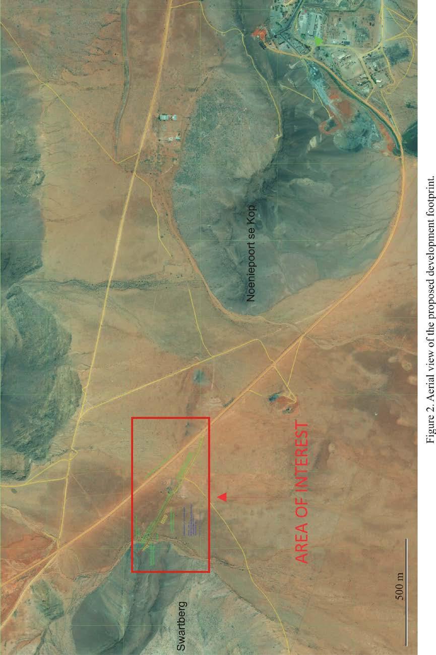
4 Introduction A Phase 1 Heritage Impact Assessment was carried out for the proposed new linear development on the Farm Zuurwater 62, situated near the town of Aggeneys between Pofadder and Springbok in the Northern Cape Province, where the Black Mountain mining company plans to construct a 800m section of gravel road and associated infrastructure at the Black Mountain Decline area (Swartberg). (Fig. 1 & 2). The region s unique and non-renewable archaeological and palaeontological heritage sites are Generally protected in terms of the National Heritage Resources Act (Act No 25 of 1999, section 35) and may not be disturbed at all without a permit from the relevant heritage resources authority. As many such heritage sites are threatened daily by development, both the environmental and heritage legislation require impact assessment reports that identify all heritage resources including archaeological and palaeontological sites in the area to be developed, and that make recommendations for protection or mitigation of the impact of the sites. The National Heritage Resources Act (NHRA) (No 25 of 1999) identifies what is defined as a heritage resource, the criteria for establishing its significance and lists specific activities for which a heritage specialist study may be required. In this regard, categories of development listed in Section 38 of the NHRA are: The construction of a road, wall, power line, pipeline, canal or other similar form of linear development or barrier exceeding 300m in length; The construction of a bridge or similar structure exceeding 50m in length; Any development or other activity which will change the character of the site; Exceeding 5000 m² in extent; Involving three or more existing erven or subdivisions thereof; Involving three or more subdivisions thereof which have been consolidated within the past five years; Costs of which will exceed a sum set in terms of regulations by the South African Heritage Resources Agency (SAHRA). The rezoning of a site exceeding m². Any other category of development provided for in regulations by the South African Heritage Resources Agency (SAHRA). 4
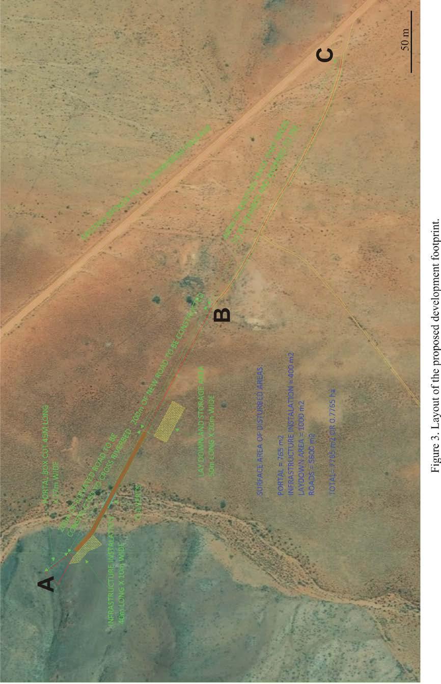
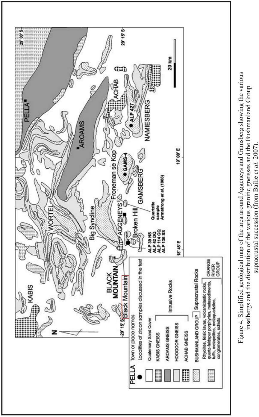
5 In many cases, the nature and degree of heritage significance is largely unknown pending further investigation (e.g. capped sites, assemblages or subsurface fossil remains). On the other hand, it is also possible that a site may contain heritage resources (e.g. structures older than 60 years), with little or no conservation value. In most cases it will be necessary to engage the professional opinion of a heritage specialist in determining whether or not further heritage specialist input in an EIA process is required. Terms of Reference Identify and map possible heritage sites and occurrences using available resources. Determine and assess the potential impacts of the proposed development on potential heritage resources; Recommend mitigation measures to minimize potential impacts associated with the proposed development. Methodology The heritage significance of the affected area was evaluated through a desktop study and carried out on the basis of existing field data, database information and published literature. This was followed by a field assessment by means of a pedestrian survey. A Garmin Etrex Vista GPS hand model (set to the WGS 84 map datum) and a digital camera were used for recording purposes. Relevant archaeological and palaeontological information, aerial photographs and site records were consulted and integrated with data acquired during the on-site inspection. Locality data 1 : scale topographic map 2918 BA Haramoep 1 : scale geological map 2918 Pofadder The study areas consists of a more or less linear footprint totalling ha of mostly rocky terrain covered by red-brown residual soils, calcretes and wind-blown sands along the lower slope of Swartberg (Black Mountain Decline) (Fig. 3). Proposed development will include the upgrading and extension of a 800 m long gravel road (5600 m 2 ) and three separate infrastructure areas covering 765m 2, 400m 2 and 1000m 2 respectively (Table 1). The area is underlain by sediments of the Namaqua-Natal Metamorphic Complex, where rocks of the Bushmanland Group and 5
6 Precambrian granites outcrop in places (Fig. 4). The prominent inselbergs and ranges of hills which characterise the arid landscape of the area are formed by the metavolcanic-metasedimentary units of the Bushmanland Group that usually occur as major, often overturned, synformal infolds in the associated granitic gneisses (Bailie et al. 2007). Geologically recent superficial deposits along the valley floors are largely made up of by gritty to gravelly, brown top soils composed of an admixture of weathered bedrock, calcretes and Quaternary wind-blown sands. Table 1. GPS coordinates of the proposed development (see Fig. 3). # GPS Coordinates A 29 14'23.80"S 18 45'7.42"E B 29 14'31.14"S 18 45'20.97"E C 29 14'37.55"S 18 45'35.37"E Background Geologically recent superficial deposits along the valley floors are largely made up of Quaternary calcretes and sands. Cenozoic river terrace deposits between Upington and Pella consists of thin remnants preserved as bedrock lags and small sediment accumulations concentrated at local bedrock knickpoints (De Wit 2006). There are currently no records of vertebrate fossil remains from alluvial contexts associated with the Orange River in the region. Paleogene fossil assemblages are known from a crater-lake deposit within a volcanic pipe at Stompoor, located about 160 km due south of Upington, and include a diversity of fish, frogs, reptiles, insects, and palynological remains (Smith 1988). Fluvial deposits from the ancient Koa Valley have yielded fossil vertebrate bone as well as fossil wood (Maglio 1978; De Wit 1996; De Wit and Bamford 1993) while a rich, Middle Miocene vertebrate site is located further downstream in proto-orange River gravel deposits on the Namibian side of the Orange River at Arrisdrift, about 40 km northeast of Oranjemund. Archaeological and historical evidence show that the Middle Orange River and Bushmanland regions have been populated more or less continuously during prehistoric times and that the region was extensively occupied by Khoi herders and 6
7 San hunter-gatherers during the last 2000 years (Morris & Beaumont 1991; Beaumont et al. 1995; Smith 1995). According to Beaumont (1986) archaeological visibility in the region was high during the Last Glacial Maximum, a viewpoint that is in contrast to that indicated for southern Africa as a whole (Deacon and Thackeray 1984). Beaumont et al also noted that MSA artifact occurrences are widespread in the Bushmanland area, but are mainly preserved as low density surface scatters on the landscape. Morris (2010, 2013a, 2013b) noted very sparse localized scatters of MSA stone tools at the top of Gamsberg, including a MSA knapping site, and ESA material, including a Victoria West core on quartzite within the Gamsberg basin. The importance of Gamsberg as an archaeological/historical focal point is further alluded to in early 19 th century records (Penn 2005) as a place of refuge and conflict during the colonial frontier period and by the meaning of its name, which is derived from the Khoikhoi word Gaams, meaning grassy spring. The principal Khoikhoi inhabitants of the Middle Orange River were the Einiqua who belonged to the same language group as the Namaqua and Korana, namely the Orange River Khoikhoi (Penn 2005). The Einiqua occupied the area around and east of the Augrabies Falls while the Korana occupied the Middle-Upper Orange River further to the east. A large number of burial cairns were excavated near the Orange River in the Kakamas area and appear to be related to Korana herders (Morris 1995). It is pointed out that while Bushmanland sites in the surrounding area appear to be ephemeral occupations by small hunter-gatherer groups, substantial herder encampments found along the Orange River itself indicate that the banks and floodplains of the river were more intensely exploited (Morris & Beaumont 1991; Beaumont 1995). Hinterland sites are mainly restricted rock shelters near mountainous terrain sand dune deposits, or around seasonal pans and springs (Beaumont 1995). Herder sites with ample pottery have been recorded near Aggeneys and, east of Pofadder, at Schuitdrift South (Morris 1999) and historical records show that herder groups settled at the stronger springs such as Pella (Thompson 1827). Pella originated as Roman Catholic mission station, about 28 km northwest of Pofadder. It was established as a station of the London Missionary Society about 1806, was taken over by the Rhenish Missionary Society until 1869, and then by the Roman Catholics in The town of Pofadder developed from a station of the Inland Mission founded in 1875, and named after Klaas Pofadder, a Korana chief. The town was laid out in 1917 and a village management board was instituted in Originally named Theronsville, the name 7
8 Pofadder was restored in Grinding grooves have been found on rock outcrops in the Gamsberg area (Morris 2011) and rock paintings, grinding surfaces and cupules sites are known from the Black Mountain Mining property at Aggeneys and at the foot of the mountain on Zuurwater 62 (Morris 2013a). No Iron Age sites are expected to be found in this area as it falls outside the southwestern periphery of distribution of Iron Age settlement in the region (Humphreys 1976). Impact Assessment Nature of Impacts It is expected that the proposed construction activities will be localized, and that potential palaeontological and archaeological impacts, if any, will be confined to the development footprint during the construction phase. Bedrock underlying the study area is not considered to be palaeontologically significant, because of the metavolcanic-metasedimentary nature of the strata. There is a low probability that well-developed Quaternary alluvial surface deposits may contain large vertebrate fossil remains or capped Stone Age occurrences. It is also likely that outcrop may yield rock art rock shelters with evidence of prehistoric human occupation. Extent of Impact Possible extent of impact following the construction activities will be locally restricted to potential damage or destruction as a result of excavations into Bushmanland Group strata and Quaternary overburden. Duration of Impact The proposed developments are considered long term with the consequence that any damage or destruction to geological strata and archaeological heritage within the affected area will be permanent. Cumulative Impact There currently exists a well-established mining footprint within a 50 km radius of the proposed developments. The proposed developments will be carried out on a landscape where mining activities is a common feature. Field Assessment The proposed footprint is primarily located on flat, open terrain covered by red-brown residual soils, calcretes and wind-blown sands. A foot survey along nearby drainage 8
9 lines (alluvium) indicate that impact on potential palaeontological heritage resources within the superficial sediments (overlying Quaternary sediments) is unlikely. No above-ground evidence was found of intact Stone Age archaeological assemblages or sites. The pedestrian survey also revealed no evidence of prehistoric structures, marked graves or rock art sites within the confines of the proposed development footprint. Impact Statement and Recommendation The field assessment provided no above-ground evidence of prehistoric structures, buildings older than 60 years, or material of cultural significance or in situ archaeological sites within the proposed development footprint. It is also considered unlikely that significant artefact occurrences will be found below the surface within the boundaries of the proposed development footprint. No further palaeontological or archaeological mitigation is required, as long as all the planned activities are restricted to within the boundaries of proposed development footprint. References Bailie, R., Armstrong, R. And Reid, D The Bushmanland Group supracrustal succession, Aggeneys, Bushmanland, South Africa: Provenance, age of deposition and metamorphism. South African Journal of Geology 110: Beaumont P.B Where did all the young men go during 0-18 Stage 2? Palaeoecology of Africa and the surrounding islands 17: Beaumont, P.B., Smith, A.B. & Vogel, J.C Before the Einiqua: the archaeology of the frontier zone. In: Smith, A.B. (ed.) Einiqualand: studies of the Orange River frontier. pp Cape Town: University of Cape Town Press. Deacon, H.J. and Thackeray, J.F Late Quaternary environmental changes and implications from the archaeological record in southern Africa. In: J.C. Vogel (ed). Late Cainozoic Palaeoclimates of the Southern Hemisphere Balkema, Rotterdam. pp De Wit, M.C.J The distribution and stratigraphy of inland alluvial deposits in South Africa. African Geoscience Review 3(2):
10 De Wit, M.C.J. and Bamford, M Fossil wood from the Brandvlei area, bushmanland as an indication of palaeoenvironmental changes during the Cainozoic. Palaeont. africana 30: De Wit, M.C.J., Marshall, T.R. and Partridge, T.C Fluvial deposits and fluvial evolution. In: T.C.Partridge and R.R. Maud (eds). The Cenozoic of Southern Africa. Oxford Monographs on Geology and Geophysics No. 40. Hendey, Q.B Preliminary report on the Miocene vertebrates from Arrisdrift, South West Africa. Annals of The South African Museum 78 : Humphreys, A.J.B Note on the Southern Limits of Iron Age Settlement in the Northern Cape. South African Archaeological Bulletin, Vol. 31 (121/122): Morris, A.G The Einiqua: an analysis of the Kakemas skeletons. In: Smith, A.B. (ed.) Einiqualand: studies of the Orange River frontier. pp Cape Town: University of Cape Town Press. Morris, D Archaeological impact assessment, Southern Option, powerline Schuitdrift to Paulputs, Pofadder District, Northern Cape. Unpublished Report to Eskom. Morris, D Cultural Heritage Assessment: Gamsberg. Supplementary observations to a previous specialist report on archaeological resources. Unpublished report to SRK Consulting. Morris, D Black Mountain Concentrated Solar Power Facility development at Aggeneys, Northern Cape. Unpublished Heritage Impact Assessment. Morris, D. 2013a. Environmental Management Plan Report for Black Mountain Mine, Aggeneys, Northern Cape: Input with respect to Heritage Resources. Unpublished Heritage Report. Morris, D. 2013b. Archaeological and Cultural Heritage Investigation for the Environmental and Social Impact Assessment (ESIA) for the Gamsberg Zinc Mine and Associated Infrastructure in Northern Cape, South Africa. Unpublished Heritage Impact Assessment. Morris, D. & Beaumont, P.B !Nawabdanas: archaeological sites at Renosterkop, Kakamas District, Northern Cape. South African Archaeological Bulletin 46:
11 Beaumont P.B. and Morris D Guide to archaeological sites in the Northern Cape. SA Association of Archaeologists Post Conference Excursion 1th 13 th Sept McGregor Museum Kimberley. Penn, N The Forgotten Frontier: Colonist and Khoisan on the Cape s Northern Frontier in the 18th Century. Athens, Ohio and Cape Town: Ohio University Press and Double Storey Books. SAHRA, Minimum Standards for the Archaeological and the Palaeontological Components of Impact Assessment Reports. Smith, A.B Archaeological observations along the Orange River and its hinterland. In A. B. Smith (ed.). Einiqualand: studies of the Orange River frontier, Cape Town: UCT Press. Thompson, G Travels and adventures in Southern Africa. Reprint Forgotton Books. 11

12 Figures 12
13 13
14 14
15 s 15
11 PALAEONTOLOGY, ARCHAEOLOGY AND CULTURAL HERITAGE IMPACTS
 11 PALAEONTOLOGY, ARCHAEOLOGY AND CULTURAL HERITAGE IMPACTS This chapter discusses the potential impacts on palaeontology, archaeology and cultural heritage resources resulting from the establishment of
DESKTOP PALAEONTOLOGICAL IMPACT ASSESSMENT. Bloemhof Extensions 11, 12 and 13 Township development in Lekwa-Teemane Local Municipality
 DESKTOP PALAEONTOLOGICAL IMPACT ASSESSMENT Bloemhof Extensions 11, 12 and 13 Township development in Lekwa-Teemane Local Municipality Specialist report by: Bruce Rubidge Address: PO Box 85346 Emmarentia
2017/03/31. Figure 9. British military graveyard at Fort Cox. Figure 10. Memorial stone. HIA: Fort Cox College Water and Sanitation Services
 2017/03/31 Figure 9. British military graveyard at Fort Cox Figure 10. Memorial stone 22 2017/03/31 Figure 11. Memorial stone Previous Studies An extensive research into the SAHRIS database resulted in
Environmental Scoping Report for the proposed establishment of a New Coal-Fired Power Station in the Lephalale Area, Limpopo Province
 12. ARCHAEOLOGICAL AND HERITAGE RESOURCES The National Cultural History Museum was contracted by Bohlweki Environmental to survey an area in which it is proposed to re-align an existing road and construct
Bestwood 1: a newly discovered Earlier Stone Age living surface near Kathu, Northern Cape Province, South Africa
 Project Gallery Antiquity Volume 086 Issue 331 March 2012 Bestwood 1: a newly discovered Earlier Stone Age living surface near Kathu, Northern Cape Province, South Africa Michael Chazan, Jayne Wilkins,
Palaeontological Desktop Study Scheding Chrome Mine, Capricorn District
 Email: bruce.rubidge@wits.ac.za 7 September 2013 Ms Zoe Gebhardt Environmental Consultant Prime Resources PO Box 2316 Parklands 2121 E-Mail: zoe@resources.co.za Dear Ms Gebhardt, Palaeontological Desktop
December 13, Kirk Shields Green Mountain Power 163 Acorn Lane Colchester, VT 05446
 December 13, 2017 Kirk Shields Green Mountain Power 163 Acorn Lane Colchester, VT 05446 RE: End of Field Letter for Archaeological Phase II Site Evaluation at Site VT-CH-1218 within the Proposed Milton
ACTON COMMUNITY WIDE ARCHAEOLOGICAL RECONNAISSANCE SURVEY. Town of Acton and PAL, Inc.
 ACTON COMMUNITY WIDE ARCHAEOLOGICAL RECONNAISSANCE SURVEY Town of Acton and PAL, Inc. Objectives and Scope of Work Four phase study; (1. research, 2. draft report outline, resource protection bylaw, 3.
Report: rock sample collection in the Northern Cape
 Report: rock sample collection in the Northern Cape 22 nd 25 th May 2011 K Allen and P Gauché Overview An exploratory trip to the Northern Cape was organised in order to look for rock samples from areas
Placer Potential Map. Dawson L and U se P lan. Jeffrey Bond. Yukon Geological Survey
 Placer Potential Map Dawson L and U se P lan By Jeffrey Bond Yukon Geological Survey Dawson Land Use Plan Placer Potential Map 1.0 Introduction Placer mining has been an important economic driver within
Belmont Development Corporation
 A PHASE 1 ARCHAEOLOGICAL IMPACT ASSESSMENT FOR THE PROPOSED RESIDENTIAL DEVELOPMENT ON THE EXISTING GRAHAMSTOWN GOLF COURSE, GRAHAMSTOWN, MAKANA MUNICIPALITY, CACADU DISTRICT MUNICIPALITY, EASTERN CAPE
NAMAQUA METAMORPHIC PROVINCE FIELD TRIP
 - 2016 NAMAQUA METAMORPHIC PROVINCE FIELD TRIP Theme: GEOLOGY AND ORIGIN OF A VERY LARGE HOT OROGEN - THE HIGH-T-LOW-P NAMAQUA METAMORPHIC PROVINCE 21-27 August 2016 Pre-conference field trip Geology to
Archaeological Heritage Impact Assessment
 Archaeological Heritage Impact Assessment Remainder Portion 54 of the Farm Hooge Kraal 238, Magisterial District George, Western Cape Province: proposed development of a small, Eco Friendly and environmentally
ENGINEER S CERTIFICATION OF FAULT AREA DEMONSTRATION (40 CFR )
") PLATTE RIVER POWER AUTHORITY RAWHIDE ENERGY STATION BOTTOM ASH TRANSFER (BAT) IMPOUNDMENTS LARIMER COUNTY, CO ENGINEER S CERTIFICATION OF FAULT AREA DEMONSTRATION (40 CFR 257.62) FOR COAL COMBUSTION RESIDUALS
PLATTE RIVER POWER AUTHORITY RAWHIDE ENERGY STATION BOTTOM ASH TRANSFER (BAT) IMPOUNDMENTS LARIMER COUNTY, CO ENGINEER S CERTIFICATION OF FAULT AREA DEMONSTRATION (40 CFR 257.62) FOR COAL COMBUSTION RESIDUALS
Appendix I-1: Archaeological Records Search
 Appendix I-1: Archaeological Records Search South Central Coastal Information Center California State University, Fullerton Department of Anthropology MH-426 800 North State College Boulevard Fullerton,
AFRICAN HERITAGE CONSULTANTS CC 2001/077745/23
 AFRICAN HERITAGE CONSULTANTS CC 2001/077745/23 DR. UDO S KÜSEL Tel: (012) 567 5046 Fax: 086 594 9721 Cell: 082 498 0673 E-mail: udo@nconnect.co.za Website: www.africanheritage.co.za P.O. Box 652 Magalieskruin
INTRODUCTION. Climate
 INTRODUCTION Climate Landslides are serious natural disasters in many parts of the world. Since the past 30 years, rainfall triggered landslides and debris flows had been one of the natural disasters of
CHAPTER 3. Field work
 CHAPTER 3 Field work 3.1. Introduction It is clear from the typological range of stone tools found on Bloubos that the environmental setting on the farm facilitated occupation over many millennia. In particular
PROPOSED CONSTRUCTION OF DYASONSKLIP SOLAR ENERGY FACILITY 1 ON THE REMAINDER OF THE FARM DYASONSKLIP 454, UPINGTON, NORTHERN CAPE
 RECOMMENDED EXEMPTION FROM FURTHER PALAEONTOLOGICAL STUDIES: PROPOSED CONSTRUCTION OF DYASONSKLIP SOLAR ENERGY FACILITY 1 ON THE REMAINDER OF THE FARM DYASONSKLIP 454, UPINGTON, NORTHERN CAPE John E. Almond
THE CROOKS GAP HOUSEPIT SITE AND OTHER NEARBY MID-HOLOCENE HOUSEPITS
 Volume 56(1 ), Spring 2012 The Wyoming Archaeologist THE CROOKS GAP HOUSEPIT SITE AND OTHER NEARBY MID-HOLOCENE HOUSEPITS by Craig S. Smith Marcia Peterson INTRODUCTION This article summarizes excavation
4.3 CULTURAL RESOURCES
 4.3 CULTURAL RESOURCES This section of the EIR analyzes the proposed project s potential impacts on archaeological and paleontological resources. This analysis summarizes the findings of the Archaeological
Description of Simandou Archaeological Potential Model. 12A.1 Overview
 12A Description of Simandou Archaeological Potential Model 12A.1 Overview The most accurate and reliable way of establishing archaeological baseline conditions in an area is by conventional methods of
Why is Sebago Lake so deep?
 Maine Geologic Facts and Localities February, 1999 Why is Sebago Lake so deep? 43 51 13.36 N, 70 33 43.98 W Text by Robert A. Johnston, Department of Agriculture, Conservation & Forestry 1 Introduction
Comprehensive and Professional Solutions for all Heritage Related Matters CK 2006/014630/23 VAT NO.:
 P.O.BOX73703 LYNNWOOD RIDGE 0040 Tel: 083 459 3091 Fax: 086 695 7247 Email: pelseranton@gmail.com Comprehensive and Professional Solutions for all Heritage Related Matters CK 2006/014630/23 VAT NO.: 4360226270
PHASE 1 ARCHAEOLOGICAL ASSESSMENT OF A PORTION OF MAIN ROAD 174 N1 TO KLIPHEUWEL
 PHASE 1 ARCHAEOLOGICAL ASSESSMENT OF A PORTION OF MAIN ROAD 174 N1 TO KLIPHEUWEL Prepared for Erica Van Den Honert (Environmental Consultant) March 1998 Prepared by Archaeology Contracts Office Department
ATTACHMENT Q PALEONTOLOGICAL RESOURCES REPORT
 ATTACHMENT Q PALEONTOLOGICAL RESOURCES REPORT LaRamie Soils Service, Inc. 217B Grand Avenue, Suite 1 P.O. Box 255 Laramie, WY 82073 geomorph@laramiesoils.com PALEONTOLOGICAL EVALUATION LANCASTER ENERGY
Starting at Rock Bottom: A Peculiar Central Texas PreClovis Culture
 Starting at Rock Bottom: A Peculiar Central Texas PreClovis Culture Background Brushy Creek grades, overall, west-northwest (WNW) to east-southeast (ESE) through the easternmost portions of the central
A study of the variation in the Rooikoppie gravels in the Lower Vaal area
 A study of the variation in the Rooikoppie gravels in the Lower Vaal area A study of the variation in the Rooikoppie gravels in the Lower Vaal area M. Ndwammbi Rockwell Diamonds Inc The Rooikoppie gravel
Archaeological Survey and Evaluation at 8954 El Dorado Parkway, El Cajon, San Diego County, California
 April 16, 2013 Ms. Andrea Bitterling Helix Environmental Planning, Inc. 7578 El Cajon Blvd., Suite 200 El Cajon, California 91942 Re: Archaeological Survey and Evaluation at 8954 El Dorado Parkway, El
The Geology of Sebago Lake State Park
 Maine Geologic Facts and Localities September, 2002 43 55 17.46 N, 70 34 13.07 W Text by Robert Johnston, Department of Agriculture, Conservation & Forestry 1 Map by Robert Johnston Introduction Sebago
Waterbury Dam Disturbance Mike Fitzgerald Devin Rowland
 Waterbury Dam Disturbance Mike Fitzgerald Devin Rowland Abstract The Waterbury Dam was completed in October 1938 as a method of flood control in the Winooski Valley. The construction began in April1935
Name. 4. The diagram below shows a soil profile formed in an area of granite bedrock. Four different soil horizons, A, B, C, and D, are shown.
 Name 1. In the cross section of the hill shown below, which rock units are probably most resistant to weathering? 4. The diagram below shows a soil profile formed in an area of granite bedrock. Four different
HERITAGE ASSESSMENT REPORT ZEUS SUBSTATION EXPANSION, VLAKFONTEIN 328, GERT SIBANDE (DC 30) DISTRICT, MPUMALANGA, SOUTH AFRICA
 DISTRICT, MPUMALANGA, SOUTH AFRICA") HERITAGE ASSESSMENT REPORT ZEUS SUBSTATION EXPANSION, VLAKFONTEIN 328, GERT SIBANDE (DC 30) DISTRICT, MPUMALANGA, SOUTH AFRICA REPORT FOR PBA INTERNATIONAL Zoë Henderson & Chriselle Koortzen 19 June 2007
HERITAGE ASSESSMENT REPORT ZEUS SUBSTATION EXPANSION, VLAKFONTEIN 328, GERT SIBANDE (DC 30) DISTRICT, MPUMALANGA, SOUTH AFRICA REPORT FOR PBA INTERNATIONAL Zoë Henderson & Chriselle Koortzen 19 June 2007
Your web browser (Safari 7) is out of date. For more security, comfort and the best experience on this site: Update your browser Ignore
 is out of date. For more security, comfort and the best experience on this site: Update your browser Ignore") Your web browser (Safari 7) is out of date. For more security, comfort and the best experience on this site: Update your browser Ignore BEDRO CK For the complete encyclopedic entry with media resources,
Your web browser (Safari 7) is out of date. For more security, comfort and the best experience on this site: Update your browser Ignore BEDRO CK For the complete encyclopedic entry with media resources,
Cretaceous, Dakota Formation, Terra Cotta Member South Side of I-70, Salina County, Kansas
 Cretaceous, Dakota Formation, Terra Cotta Member South Side of I-70, Salina County, Kansas Written By: Steven D.J. Baumann G-102010-1A Outcrop looking southeast Photo taken by: Steven Baumann on 10-20-2010
AN ARCHAEOLOGICAL SURVEY FOR THE EASTHAM STATE PRISON FARM UNIT PROJECT IN HOUSTON COUNTY TEXAS
 AN ARCHAEOLOGICAL SURVEY FOR THE EASTHAM STATE PRISON FARM UNIT PROJECT IN HOUSTON COUNTY TEXAS Antiquities Permit 5693 By William E. Moore and Edward P. Baxter Brazos Valley Research Associates Contract
BUTE MAP 6: GARROCH HEAD to STRAVANNAN BAY
 BUTE MAP 6: GARROCH HEAD to STRAVANNAN BAY Hinterland Geology and Coastal Geomorphology: Old Red Sandstone and lavas form the principal base deposits and are overlain by marine deposits towards Port Dornoch.
Selected Archeological Terms
 Page 1 of 6 Selected Archeological Terms Links General Reference Bibliographies Glossaries Terms A b C D E F G H i j k l M N O P q R S T U V w x y z ADAPTATION: The process of change to better conform
J.H. Campbell Generating Facility Pond A - Location Restriction Certification Report
 J.H. Campbell Generating Facility Pond A - Location Restriction Certification Report Pursuant to: 40 CFR 257.60 40 CFR 257.61 40 CFR 257.62 40 CFR 257.63 40 CFR 257.64 Submitted to: Consumers Energy Company
Guidance for implementing the Potential Fossil Yield Classification (PFYC) System
 System") Guidance for implementing the Potential Fossil Yield Classification (PFYC) System Introduction The PFYC system will aid in assessing the potential to discover or impact significant paleontological resources.
Guidance for implementing the Potential Fossil Yield Classification (PFYC) System Introduction The PFYC system will aid in assessing the potential to discover or impact significant paleontological resources.
Practice 3rd Quarter Exam Page 1
 Name 1. Which characteristic would most likely remain constant when a limestone cobble is subjected to extensive abrasion? A) shape B) mass C) volume D) composition 2. Which activity demonstrates chemical
AN ARCHAEOLOGICAL SURVEY FOR THE DCP MIDSTREAM THREE RIVERS PLANT TO CGP 51 PROJECT IN LIVE OAK COUNTY, TEXAS
 AN ARCHAEOLOGICAL SURVEY FOR THE DCP MIDSTREAM THREE RIVERS PLANT TO CGP 51 PROJECT IN LIVE OAK COUNTY, TEXAS By William E. Moore Brazos Valley Research Associates Contract Report Number 251 2011 AN ARCHAEOLOGICAL
PALEOGEOGRAPHY of NYS. Definitions GEOLOGIC PROCESSES. Faulting. Folding 9/6/2012. TOPOGRAPHIC RELIEF MAP of NYS GRADATIONAL TECTONIC
 TOPOGRAPHIC RELIEF MAP of NYS PALEOGEOGRAPHY of NYS Prof. Anthony Grande AFG 2012 Definitions GEOLOGIC PROCESSES Geography: study of people living on the surface of the earth. Geology: the scientific study
 Page 1 of 9 Name: Base your answer to the question on the diagram below. The arrows show the direction in which sediment is being transported along the shoreline. A barrier beach has formed, creating a
SL GEOLOGY AND MINING. Coal bearing strata in the project area are referable primarily to the Allegheny Group of
 SL-145-1 GEOLOGY AND MINING Coal bearing strata in the project area are referable primarily to the Allegheny Group of Pennsylvania age. These rocks occur as dissected remnants overlying the ridge-forming
An Introduction to Field Explorations for Foundations
 An Introduction to Field Explorations for Foundations J. Paul Guyer, P.E., R.A. Paul Guyer is a registered mechanical engineer, civil engineer, fire protection engineer and architect with over 35 years
GEO-STABILITY DESKTOP STUDY FOR A PROPOSED FILLING STATION AT ROODEKRANS MOGALE CITY, GAUTENG
 GEO-STABILITY DESKTOP STUDY FOR A PROPOSED FILLING STATION AT ROODEKRANS MOGALE CITY, GAUTENG Page 1 of 11 GEO-STABILITY DESKTOP STUDY FOR A PROPOSED FILLING STATION AT ROODEKRANS MOGALE CITY, GAUTENG
4.11 CULTURAL RESOURCES
 4.11 CULTURAL RESOURCES 4.11 CULTURAL RESOURCES This section summarizes the cultural resources of. Information reviewed for the summary includes the General Plan, published reports on archaeological research
SURFICIAL GEOLOGY AND PERFORMANCE ASSESSMENT FOR A RADIOACTIVE WASTE MANAGEMENT FACILITY AT THE NEVADA TEST SITE
 DOE/NV/ 10833-25 UC72 1 SURFICIAL GEOLOGY AND PERFORMANCE ASSESSMENT FOR A RADIOACTIVE WASTE MANAGEMENT FACILITY AT THE NEVADA TEST SITE K. E. Snyder Lockheed Environmental Systems and Technologies Co.
Ch 10 Deposition Practice Questions
 1. Base your answer to the following question on the data table below. Six identical cylinders, A through F, were filled with equal volumes of sorted spherical particles. The data table shows the particle
4.17 Spain. Catalonia
 4.17 Spain Catalonia In Spain, inundation studies are the responsibility of the respective Hydrographic Confederations of each river basin (River Basin Authorities). The actual status of inundation studies
Plate 51. Site 035. Collection of remains. Scale is in cm. Plate 50. Site 034. Collection of remains. Scale is in cm
 Plate 48. Site 033. View facing north west Plate 49. Site 034. View facing north Pottery Pottery Ostrich eggshell Plate 50. Site 034. Collection of remains. Scale is in cm Plate 51. Site 035. Collection
Heritage Survey report for THE KOMATI POWER STATION ASH DAM EXTENSION, MIDDELBURG MAGISTERIAL DISTRICT, MPUMALANGA PROVINCE
 report for THE KOMATI POWER STATION ASH DAM EXTENSION, MIDDELBURG MAGISTERIAL DISTRICT, MPUMALANGA PROVINCE THE PROJECT: Development of a new ash dam for the coal fired power station. THIS REPORT: Heritage
Glossary of Common Terms. Guide 2. BAJR Practical Guide Series held by authors
 Glossary of Common Terms Guide 2 BAJR Practical Guide Series 2008 held by authors Glossary of common archaeological terms : compiled 28/04/2004 absolute dating: Absolute dating is based upon a specific
EVALUATION OF AQUIFER CHARACTERISTICS FOR SELECTED NEW METHOD OF THE UM RUWABA FORMATION: NORTH KORDOFAN STATE, SUDAN
 EVALUATION OF AQUIFER CHARACTERISTICS FOR SELECTED NEW METHOD OF THE UM RUWABA FORMATION: NORTH KORDOFAN STATE, SUDAN ELHAGA.B *1; ELZIENS.M*2 ANDLISSANN.H*3 *1Department of C i v i l E n g i n e e r i
Prehistoric Clay Sources: A Forensic Exercise in Geoarchaeology
 Prehistoric Clay Sources: A Forensic Exercise in Geoarchaeology Lynn Ketterhagen Faculty Sponsor: Dean Wilder, Department of Geography and Earth Science ABSTRACT The prehistoric Oneota culture of the Upper
MERCURY - PERSEUS TRANSMISSION LINE ENGINEERING GEOLOGICAL ASSESSMENT FOR ROUTE 1
 MERURY - PERSEUS TRANSMISSION LINE ENGINEERING GEOLOGIAL ASSESSMENT FOR ROUTE 1 Prepared by: I KLEINHANS KNIGHT HALL HENDRY P.O. Box 72292 Lynnwood Ridge 0040 Prepared for: STRATEGI ENVIRONMENTAL FOUS
Autumn Term Spring Term Summer Term Year Group
 History and Geography Long Term Plan 16/17 Autumn Term Spring Term Summer Term Year Group Fire Food and Farming Journeys Giraffes, 1 and 2 Great fire of London significant event. Hot weather/seasonal/equat
Map 12: Ayrshire Coast: Doonfoot Beach to Dunure Map Content Descriptions
 Map 12: Ayrshire Coast: Doonfoot Beach to Dunure Map Content Descriptions 1. Built Heritage and Archaeology A total of twenty three sites were located in the area covered by Map 12. Of these seventeen
Page 1. Name:
 Name: 1) Which property would best distinguish sediment deposited by a river from sediment deposited by a glacier? thickness of sediment layers age of fossils found in the sediment mineral composition
1. The diagram below shows the stump of a tree whose root grew into a small crack in bedrock and split the rock apart.
 1. The diagram below shows the stump of a tree whose root grew into a small crack in bedrock and split the rock apart. 4. Which process involves either a physical or chemical breakdown of earth materials?
2 Aggregates in Indiana
 2 Aggregates in Indiana Origin of Aggregates Gravel and Natural Sands Crushed Stone Slag Distribution of Aggregates Glacial Deposits Bedrock Deposits Aggregate Types Natural Aggregates Artificial Aggregates
(Assessment conducted under Section 38 (8) of the National Heritage Resources Act as part of an EIA.) Prepared for
 of the National Heritage Resources Act as part of an EIA.) Prepared for") SCOPING HERITAGE ASSESSMENT FOR THE PROPOSED CONSTRUCTION OF A 400 kv TRANSMISSION LINE BETWEEN ANKERLIG POWER STATION (ATLANTIS) AND THE PROPOSED OMEGA SUBSTATION, GROOT OLIFANTSKOP. (Assessment conducted
SCOPING HERITAGE ASSESSMENT FOR THE PROPOSED CONSTRUCTION OF A 400 kv TRANSMISSION LINE BETWEEN ANKERLIG POWER STATION (ATLANTIS) AND THE PROPOSED OMEGA SUBSTATION, GROOT OLIFANTSKOP. (Assessment conducted
General Geologic Setting and Seismicity of the FHWA Project Site in the New Madrid Seismic Zone
 General Geologic Setting and Seismicity of the FHWA Project Site in the New Madrid Seismic Zone David Hoffman University of Missouri Rolla Natural Hazards Mitigation Institute Civil, Architectural & Environmental
Controls on the Distribution of Drift Filled Hollows in London
 Controls on the Distribution of Drift Filled Hollows in London Stephanie Bricker, Vanessa Banks and Kate Royse Engineering Geology of Scour Features Geol Soc. London, 22 January 2013 Outline 1. Why study
HONDURAN INSTITUTE OF ANTHROPOLOGY AND HISTORY SURFACE SURVEY NUEVA ARCADIA AND LA COFRADÍA WIND PROJECT
 HONDURAN INSTITUTE OF ANTHROPOLOGY AND HISTORY SURFACE SURVEY NUEVA ARCADIA AND LA COFRADÍA WIND PROJECT PROVINCE OF FRANCISCO MORAZAN Prepared for The Sub Management of Heritage I.H.A.H. II. Researcher:
ARCHAEOLOGICAL METHOD FEHMARN STYLE
 ARCHAEOLOGICAL METHOD FEHMARN STYLE Digital archaeology By: Nadja M. K. Mortensen, Prehistoric Archaeologist, Responsible for GIS Overview of the survey area Digital measuring and registration are an important
Cape Breton Island Mineral Inventory Studies: A Sandstone Quarry Development Opportunity at Graham River (NTS 11F/14), Inverness County
, Inverness County") Report of Activities 2001 23 Cape Breton Island Mineral Inventory Studies: A Sandstone Quarry Development Opportunity at Graham River (NTS 11F/14), Inverness County G. J. DeMont and J. E. Hawken Compilation
Report of Activities 2001 23 Cape Breton Island Mineral Inventory Studies: A Sandstone Quarry Development Opportunity at Graham River (NTS 11F/14), Inverness County G. J. DeMont and J. E. Hawken Compilation
PW Parkway ES Prince William County, Virginia WSSI #
 PW Parkway ES Prince William County, Virginia WSSI #15.3 Cultural Resources Site Assessment November 15 Prepared for: Prince William County Public Schools P.O. Box 39 Manassas, Virginia 1 Prepared by:
Abrasion: The physical weathering of rocks by particles rubbing against each other.
 FOSS Earth History Course Glossary (10-4-04) Abrasion: The physical weathering of rocks by particles rubbing against each other. Absolute age: The exact age of an object (such as a rock or artifact); found
Archaeological Survey and Assessment of Four Wastewater Interceptor Routes in Garner, Wake Co., N.C. (EPA C )
") Archaeological Survey and Assessment of Four Wastewater Interceptor Routes in Garner, Wake Co., N.C. (EPA C370623-02) By H. Trawick \vard R. P. Stephen Davis Prepared by the Research Laboratories of Anthropology
Archaeological Survey and Assessment of Four Wastewater Interceptor Routes in Garner, Wake Co., N.C. (EPA C370623-02) By H. Trawick \vard R. P. Stephen Davis Prepared by the Research Laboratories of Anthropology
Glacial landscape. Arid Landscape. Geological feature. Extreme drainage. In this location you should find the following features:
 Glacial landscape In this location you should find the following features: Alluvial fan Braided river End moraines Glacial niche Talus cone U-valley Try to determine the altitude of the tree limit in the
Cenozoic Extensional Basin Development and Sedimentation in SW Montana
 Cenozoic Extensional Basin Development and Sedimentation in SW Montana Robert C. Thomas Department of Environmental Sciences, The University of Montana Western, Dillon, MT 59725, (406) 683-7615, r_thomas@umwestern.edu
Name Roy G Biv Page 1
 Name Roy G Biv Base your answers to questions 1 through 3 on the diagram below. The arrows show the direction in which sediment is being transported along the shoreline. A barrier beach has formed, creating
Swaledale and Arkengarthdale Archaeology Group
 Swaledale and Arkengarthdale Archaeology Group Bellerby Moor GPS Earthwork Survey Report prepared by: Tim Laurie and Stephen Eastmead. Swaledale and Arkengarthdale Archaeology Group. January 27/01/2012.
Starting at Rock Bottom
 Starting at Rock Bottom At rock bottom of the Brushy Creek site s geological column lies the first clue to human habitation: A smelting and heattreating furnace, and mold, carved into Bed Ked: Figure 15
Archaeological Predictive Modeling within the context of Paleo-river Terraces in the City of Prince George
 Archaeological Predictive Modeling within the context of Paleo-river Terraces in the City of Prince George Background The documented pre-contact archaeological record of the Interior Plateau of B.C. is
Hydraulic Impacts of Limestone Quarries and Gravel Pits. Jeff Green Minnesota DNR-Division of Ecological & Water Resources
 Hydraulic Impacts of Limestone Quarries and Gravel Pits Jeff Green Minnesota DNR-Division of Ecological & Water Resources The Hydraulic Impacts of Limestone Quarries and Gravel Pits Study was funded by
Map Introduction: South Uist Map 1
 96 Map Introduction: Map This map section covers part of the south coast of, including the head of the causeway which links the island to Eriskay. It extends from South Glen Dale to Taobh a'caolas. There
RE: End of Field Letter for the Proposed Milton Mears Farm Road Solar Project, Milton, Chittenden County, Vermont
 October 10, 2017 Kirk Shields Green Mountain Power 163 Acorn Lane Colchester, VT 05446 RE: End of Field Letter for the Proposed Milton Mears Farm Road Solar Project, Milton, Chittenden County, Vermont
Flash flood disaster in Bayangol district, Ulaanbaatar
 Flash flood disaster in Bayangol district, Ulaanbaatar Advanced Training Workshop on Reservoir Sedimentation Management 10-16 October 2007. IRTCES, Beijing China Janchivdorj.L, Institute of Geoecology,MAS
Terrain Units PALEOGEOGRAPHY: LANDFORM CREATION. Present Geology of NYS. Detailed Geologic Map of NYS
 NYS TOPOGRAPHY Why so? PALEOGEOGRAPHY: LANDFORM CREATION Prof. Anthony Grande AFG 014 Present Geology of NYS Detailed Geologic Map of NYS Generalized Geology Detailed Geology Hot links to the fold out
PRE 8. Craton Traverse: A transect through ~2.7Ga of South African history. Field Trip Leader: Herman van Niekerk
 PRE 8 Craton Traverse: A transect through ~2.7Ga of South African history Field Trip Leader: Herman van Niekerk This field trip is a great traverse that covers a large part of the geology of South Africa,
3.12 Geology and Topography Affected Environment
 3 Affected Environment and Environmental Consequences 3.12 Geology and Topography 3.12.1 Affected Environment 3.12.1.1 Earthquakes Sterling Highway MP 45 60 Project Draft SEIS The Kenai Peninsula is predisposed
The River Otter: A Field Guide to the. Palaeolithic Landscape Picture of Otter Valley taken by Laura Basell (PRoSWeB)
") The River Otter: A Field Guide to the Palaeolithic Landscape Picture of Otter Valley taken by Laura Basell (PRoSWeB) Produced by The Palaeolithic Rivers of South-West Britain Project and the National Ice
The River Otter: A Field Guide to the Palaeolithic Landscape Picture of Otter Valley taken by Laura Basell (PRoSWeB) Produced by The Palaeolithic Rivers of South-West Britain Project and the National Ice
Module 10: Resources and Virginia Geology Topic 4 Content: Virginia Geology Notes
 Virginia is composed of a very diverse landscape that extends from the beaches and barrier islands all of the way to the highly elevated Appalachian Plateau. Geologists have discovered ancient shallow
Converse Consultants Geotechnical Engineering, Environmental & Groundwater Science, Inspection & Testing Services
 Converse Consultants Geotechnical Engineering, Environmental & Groundwater Science, Inspection & Testing Services Ms. Rebecca Mitchell Mt. San Antonio College Facilities Planning & Management 1100 North
Description DESCRIPTION
 DESCRIPTION The location of the Upper James Watershed is located in northeastern South Dakota as well as southeastern North Dakota. It includes the following counties located in North Dakota Barnes, Dickey,
4.5 GEOLOGY, SOILS AND SEISMICITY
 4.5 This section summarizes information on geology, soils and seismic hazards, and mineral resources in the Truckee area, as well as potential area-wide geologic hazards and regional seismic characteristics
The last three sections of the main body of this report consist of:
 Threatened and Endangered Species Geological Hazards Floodplains Cultural Resources Hazardous Materials A Cost Analysis section that provides comparative conceptual-level costs follows the Environmental
PLANNING FOR THE FUTURE
 PLANNING FOR THE FUTURE Guidance for Managing the Archaeological and Palaeoenvironmental Resource in the Till-Tweed Valleys, Northumberland, UK And The University of Newcastle upon Tyne Authors: Clive
Agate Fossil Beds National Monument
 University of Nebraska - Lincoln DigitalCommons@University of Nebraska - Lincoln U.S. National Park Service Publications and Papers National Park Service 2014 Follow this and additional works at: http://digitalcommons.unl.edu/natlpark
Phase 2 Archaeological Assessment of Late Iron Age Structures on the Farm Ledig 909 JQ (Quality Vacation Club and Golf Course), North West Province
, North West Province") Francois P Coetzee Phase 2: Ledig 909JQ Phase 2 Archaeological Assessment of Late Iron Age Structures on the Farm Ledig 909 JQ (Quality Vacation Club and Golf Course), North West Province For Chand Environmental
Francois P Coetzee Phase 2: Ledig 909JQ Phase 2 Archaeological Assessment of Late Iron Age Structures on the Farm Ledig 909 JQ (Quality Vacation Club and Golf Course), North West Province For Chand Environmental
Mineral activities within Rich County, Utah
 Natural Resources and Environmental Issues Volume 14 Bear Lake Basin Article 10 1-1-2007 Mineral activities within Rich County, Utah Patsy Palacios SJ & Jessie E Quinney Natural Resources Research Library,
The Rural Settlement of Roman England
 The Rural Settlement of Roman England Roman settlement at Claydon Pike Oxford Archaeology Settlement morphology and regional diversity: establishing a new model Alex Smith Aims of Project Phase 1 To gain
Converse Consultants Geotechnical Engineering, Environmental & Groundwater Science, Inspection & Testing Services
 Converse Consultants Geotechnical Engineering, Environmental & Groundwater Science, Inspection & Testing Services July 27, 2017 Ms. Rebecca Mitchell Mt. San Antonio College Facilities Planning & Management
Ground-Water Exploration in the Worthington Area of Nobles County: Summary of Seismic Data and Recent Test Drilling Results
 Ground-Water Exploration in the Worthington Area of Nobles County: Summary of Seismic Data and Recent Test Drilling Results Jim Berg and Todd Petersen Geophysicists, DNR Waters January 2000 Table of Contents
Guidelines for Site-Specific Seismic Hazard Reports for Essential and Hazardous Facilities and Major and Special-Occupancy Structures in Oregon
 Guidelines for Site-Specific Seismic Hazard Reports for Essential and Hazardous Facilities and Major and Special-Occupancy Structures in Oregon By the Oregon Board of Geologist Examiners and the Oregon
Lapita and Later Archaeology of the Malolo and Mamanuca Islands, Fiji
 Journal of Island & Coastal Archaeology, 2:245 250, 2007 Copyright 2007 Taylor & Francis Group, LLC ISSN: 1556-4894 print / 1556-1828 online DOI:10.1080/15564890701622896 Lapita and Later Archaeology of
MINNESOTA DEEP TEST PROTOCOL PROJECT
 MINNESOTA DEEP TEST PROTOCOL PROJECT Mn/DOT Agreement No. 85878 OSA License No. 04-030 Authorized and Sponsored by: MINNESOTA DEPARTMENT OF TRANSPORTATION FEDERAL HIGHWAY ADMINISTRATION Prepared by COMMONWEALTH