ATTACHMENT Q PALEONTOLOGICAL RESOURCES REPORT
|
|
|
- Clare Edwards
- 5 years ago
- Views:
Transcription
1 ATTACHMENT Q PALEONTOLOGICAL RESOURCES REPORT
2 LaRamie Soils Service, Inc. 217B Grand Avenue, Suite 1 P.O. Box 255 Laramie, WY geomorph@laramiesoils.com PALEONTOLOGICAL EVALUATION LANCASTER ENERGY FACILITY SITE AND GAS PIPELINE RIGHT-OF-WAY Prepared for DAN HART PRINCIPAL ARCHAEOLOGIST GARCIA AND ASSOCIATES 1550 SOUTH WELLS AVE. SUITE 104 RENO, NV Prepared by Dr Michael Cassiliano Principal Paleontologist LaRamie Soils Service April 25, 2001 LRSS
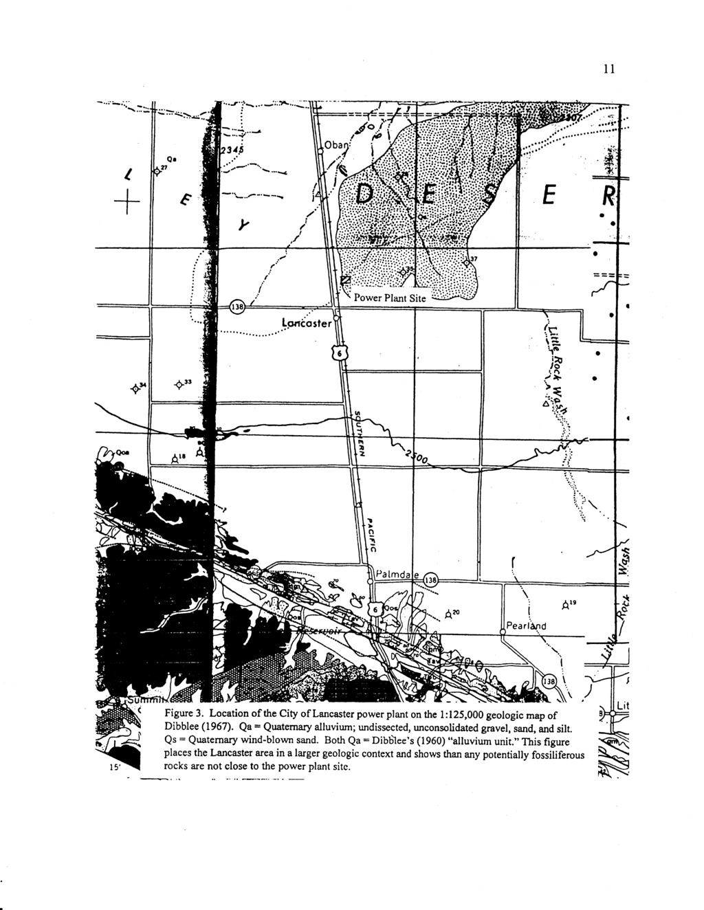
3 1 Executive Summary Rock formations in the proposed energy facility site and the pipeline right-of-way have extremely limited potential to yield vertebrate fossils. Except for the Mesozoic igneous and the volcanic Oligocene-Miocene rocks in the Rosamond Hills portion of pipeline right-of-way, the entire study area encompasses a relatively featureless Holocene and Pleistocene landscape devoid of recorded vertebrate fossil localities or outcrops capable of yielding vertebrate fossils. The origin of igneous rocks precludes their potential to preserve or yield vertebrate fossils. Vertebrate fossils have been found in the foothills of the San Gabriel Mountains in the Harold Formation. Portions of the Harold Formation that are located within the proposed energy facility and pipeline right-of-way area; however, at least 400 feet below the surface and are not expected to be affected by construction or operational activities. Based on findings from a literature and database search, and a field survey: 1) the City of Lancaster Energy Facility site and the pipeline right-of-way are not considered paleontologically sensitive, and 2) vertebrate fossils are not expected to be found during construction. Introduction The proposed Lancaster Energy Facility and the gas pipeline right-of-way are located in the Antelope Valley area of southern California. Map coverage is on the West Lancaster, Rosamond, Soledad Mountain, and Mojave 7.5 Minute topographic maps (1:24000) published by the U.S. Geological Survey (Figure 1). Antelope Valley consists of two structural basins, the West and East Antelope Basins, separated from each other by a buried structural high (Dibblee 1967). The entire Antelope Valley is bounded to the south and southwest by the San Andreas Fault and Transverse Ranges and bounded to the north and northwest by the Garlock Fault and Tehachapi Mountains (Dibblee 1967; Woodburne 1975; Ponti1985). To the east, Antelope Valley is confluent with a series of small basins that eventually lead to the Colorado River Valley. Antelope Valley forms the westernmost wedge of the Mojave Desert and is within the larger Basin and Range physiographic provenience (Ponti 1985). The proposed natural gas pipeline right-of-way extends from the proposed energy facility site at the intersection of Avenue H and Division Street in Lancaster to a
4 2 connection with an existing pipeline near the intersection of Highways 14 and 58 in Mojave. The right-of-way parallels the Sierra Highway and Union Pacific Railroad tracks to a point south of Mojave where it parallels Highway 14 to its connection with the existing pipeline. Methods Prior to a field survey, published literature and electronic databases was reviewed to determine if there were published or known vertebrate fossil localities in either the proposed Lancaster Energy Facility site or pipeline right-of-way. A pedestrian survey of the site was conducted on March 24, A vehicular survey that included pedestrian examination of potential outcrops within the proposed right-of-way was conducted April 21, Geologic Summary Geologic studies of Antelope valley have concentrated on the mountains that surround the valley (Dibblee, 1967; Woodburne, 1975). Filling of the Antelope Valley basins apparently began in the latest Oligocene (about 25 million years ago) and continues to the present (Woodburne, 1975; Ponti, 1985). Most of the basin fill, more than 6,000 feet thick, consists of loosely consolidated, Quaternary age (1.8 million years ago to 10,000 years ago) sediments (Ponti, 1985) and reflects a change in drainage patterns caused by the uplift of the San Gabriel Mountains between one and two million years ago (Woodburne, 1975). The majority of the rocks exposed at the surface in Antelope Valley are late Quaternary (<500,000 years) and Holocene (<10,000 years old) in age (Ponti, 1985). The names given to the Quaternary and Holocene rocks vary according to who mapped them (Table 1). Geologic maps of Antelope Valley that include the energy facility site and the pipeline right-of-way were published by Dibblee (1960, 1967) and Ponti et al. (1981). Dibblee (1960, 1967) did not map the Quaternary sediments in great detail (Figures 2 and 3). He simply divided the rocks into a younger alluvium (about 100 feet thick) and an older alluvium (more than 1,000 feet thick). Dibblee s younger alluvium is probably late
5 3 Quaternary and Holocene in age, and the older alluvium is most likely middle and early Quaternary in age. He noted that most of the basin fill in Antelope Valley was the older alluvium that included the Harold Formation and Nadeau Gravel of Nobel (1953). The proposed energy facility would be built on Dibblee s younger alluvium unit, specifically the facies he mapped as clay and silt. Except for the Rosamond Hills, all of the proposed pipeline right-of-way will traverse the younger alluvial unit of Dibblee (1960, 1967). Ponti et al. (1981) mapped the different facies of Dibblee s (1960, 1967) younger alluvium in greater detail based on lithologic, pedologic, and geomorphic criteria. Ponti (1985) described and interpreted these map units and informally divided Dibblee s (1960, 1967) younger alluvium unit into eight sets of deposits. From oldest to youngest they are: the lower, middle, and upper Tylerhorse deposits; lower, middle and upper Palmdale deposits; and post-palmdale I and II deposits (Table 1). Collectively, these units have a minimum thickness of 418 feet. Upper Palmdale deposits (minimum thickness of 37 feet) cover most of the floor of Antelope Valley. The energy facility site is located on this unit, which is equivalent, in part, to Dibblee s (1960, 1967) younger alluvium. According to Ponti (1985, pg. 83) the upper Palmdale deposits form low terraces in valleys along the foothills and grade into broad, smooth alluvial fans that blanket the basin floor. The surfaces of these deposits are generally flat-lying and undissected, but modern channels are incised at least 1 m. In addition to alluvial fan deposits, the formations of Ponti et al. (1981) and Ponti (1985) also include lakebeds that formed in Lake Thompson, an extinct lake that filled part of Antelope Valley during the Quaternary (Dibblee, 1960, 1967). Rogers and Rosamond dry lakes occupy parts of the ancient bed of Lake Thompson. These late Quaternary and Holocene rocks are composed of gravel, sand, silt and clay. Cementation tends to be poor. Paleosols are developed to varying degrees of maturity in these late Quaternary and Holocene units (Ponti, 1985). The composition and placement of the rocks are important in determining potential vertebrate fossil localities. The older alluvium of Dibblee (1960, 1967) is not exposed at the surface in the area of the energy facility and is exposed only in a very limited area along the pipeline right-of-way (Figures 2 and 3). Dibblee s older alluvium has, however, been mapped in other areas of the Mojave Desert as the Harold Formation, Shoemaker Gravel, and
6 4 Nadeau Gravel (Nobel, 1953, 1954; Woodburne, 1975). These rocks are thought to be early and middle Quaternary in age (1.8 to 0.5 million years old) and are exposed only in the foothills of the Transverse Ranges and Tehachapi Mountains where fault movements and folding have brought them to the surface. Dibblee (1967), Woodburne (1975), and Ponti (1985) all assume that the late Quaternary rocks cover the older alluvium that underlies much or all of Antelope Valley. Nobel (1953, 1954) was of the opinion that the Harold Formation, Shoemaker Gravel, and Nadeau Gravel were deposited in small basins adjacent to the San Andreas Fault rather than forming widespread deposits. No studies were identified that examined the deep subsurface older geology of either basin underlying Antelope Valley. Thus, the actual geologic formations underlying the late Quaternary and Holocene rocks are unknown. Lack of knowledge regarding the subsurface geology should not be an issue, however, unless the City of Lancaster energy facility and pipeline right-of-way foundations, footings or trenches are planned to be deeper than 400 feet. Rosamond Hills A segment of the pipeline right-of-way traverses a low saddle in the Rosamond Hills. Most of the rocks in the Rosamond Hills are intrusive and extrusive igneous (volcanic); however, there are also some re-deposited volcanic rocks and Quaternaryaged older alluvium (Dibblee 1967). Dibblee (1967) described the geologic formations in the Rosamond Hills from south to north within the right-of-way as: 1. An unnamed fanglomerate (sedimentary rock formed mainly of pebbles and cobbles with angular edges) that is part of the older alluvium unit of Quaternary age, 2. The Fiss Fanglomerate of possible Miocene age (23.5 to 5.5 million years ago); a brown colored rock derived from reworked volcanics deposited by water and gravity, 3. The Gem Hill Formation of possible Oligocene to middle Miocene age (34 to 11.2 million years ago). It consists of reworked volcanics from the Bobtail Quartz Latite Member of the Gem Hill Formation and an unnamed unit of rhyolite tuff, tuff breccia, tuffaceous sandstone, and conglomerate. This
7 5 unnamed member of the Gem Hill Formation is mix of air-fall and re-worked volcanic ash; and 4. Quartz monzonite, a Mesozoic intrusive igneous rock (magma emplaced below the surface where it cooled into rock and later exposed by uplift and erosion). No fossils are expected in the intrusive or extrusive igneous rocks; this type of rock forms from magma (very hot molten rock) that destroys any organic material. Dibblee (1967) also reported finding no fossils in the Rosamond Hills sedimentary rocks. Vertebrate Paleontology of the Lancaster Energy Facility Site A search of published literature and electronic databases for vertebrate fossil localities with regard to the Lancaster area, Antelope Valley, and the geologic rock units in these areas showed that there are: 1. No known vertebrate fossil localities at the energy facility site or the pipeline right-of-way. 2. The rocks included in the alluvial units of Dibblee (1960, 1967) or the Tylerhorse, Palmdale, post-palmdale deposits of Ponti (1985) are not fossiliferous. 3. There have been no surveys for vertebrate fossils in the area of the proposed energy facility site, within the city limits of the City of Lancaster or within the proposed pipeline right-of-way. The nearest vertebrate fossil locality is within the Harold Formation in the foothills on the north side of the San Gabriel Mountains (Nobel, 1953, 1954). No information was given about these fossils other than to list their taxa. Because Nobel worked for the U.S. Geological Survey, the fossils are presumably stored at a U.S. Geological Survey facility or the Smithsonian Institution. While portions of the Harold Formation are located within the proposed energy facility and pipeline right-of-way area, they are at least 400 feet below the surface and are not expected to be affected by construction or operational activities.
8 6 The potential for vertebrate fossils in the rocks immediately under the energy facility site or the pipeline right-of-way site is predicted to be extremely low. Based on findings from literature and database searches, it is predicted that the Lancaster Energy Facility site and the pipeline right-of-way are not paleontologically sensitive, and no vertebrate fossils are expected to be found during construction. Field survey results The Lancaster Energy Facility site is flat, and lacks outcrops of older formations that might yield vertebrate fossils. The only relief on the site consists of low mounds of coarse sand and silt held together by plant roots. (Figure 4). Areas between the vegetation mounds consist of very fine-grained sand, silt, and clay. Local residents have used the site as a garbage dump. As predicted from the literature and database searches, no vertebrate fossils were found during the field survey. The only bones found were those of modern rabbit, cow and pig found in a garbage dump. The cow and pig bones show clear evidence of having come from a butcher shop. None of these bones qualifies as a fossil. Geologically, the proposed pipeline right-of-way crosses three distinct areas (Figure 5). The first area extends from Lancaster to the Rosamond Hills (Figure 6). It is underlain by rocks of latest Pleistocene and Holocene age, i.e., the younger alluvium of Dibblee (1960, 1967) or the Upper Palmdale deposits of Ponti (1985). This area is very flat and there were no exposed outcrops (places to explore for fossils). The second area consists of the low saddle through the Rosamond Hills (Figure 7). The rocks in the Rosamond Hills are mostly intrusive and extrusive (volcanic) igneous with some re-deposited volcanics plus very limited outcrops of the older alluvium unit (Dibblee, 1967). The third area extends from the Rosamond Hills to Mojave and consists of Dibblee s (1960, 1967) younger alluvium unit. Like the first area, the third is flat and no outcrops were found. The only outcrop of rock that could be examined for possible fossils was of the Fiss Fanglomerate in the Rosamond Hills (Figure 8). No fossils were found either at this outcrop or at any other location within the right-of-way. Much of the terrain within the
9 7 right-of-way has already been disturbed by the construction of the railroad, Sierra Highway, Highway 14, a fiber optic cable, and another pipeline. Conclusions Based on findings from a literature and database search, and a field survey: 1) the City of Lancaster energy facility site and the pipeline right-of-way are not considered paleontologically sensitive, and 2) vertebrate fossils are not expected to be found during construction. References Dibblee, T.W. Jr., 1960, Geologic map of the Lancaster Quadrangle, Los Angeles County, California: United States Geological Survey Mineral Investigations, Field Studies Map MF-76, scale 1:62,500. Dibblee, T.W., Jr., 1967, Areal geology of the western Mojave Desert, California: United States Geological Survey Professional Paper 522, 153 p. Nobel, L.F., 1953, Geology of the Pearland Quadrangle, California: United States Geological Survey, Geologic Quadrangle Map GQ-24, scale 1:24,000. Nobel, L.F. 1954, Geology of the Valyermo Quadrangle and Vicinity, California: United Sates Geological Survey, Geologic Quadrangle Map GQ-50, scale 1:24,000. Ponti, D.J., 1985, The Quaternary alluvial sequence of the Antelope Valley, California, in Weide, D.L., ed., Soils and Quaternary Geology of the Southwestern United States: Geological Society of America, Special Paper 203, p Ponti, D.J., Burke, D.B., and Hedel, C.W., 1981, Map showing Quaternary geology of the central Antelope Valley and vicinity, California: United States Geological Survey Open-File Report , scale 1: 62,500. Woodburne, M.O., 1975, Cenozoic stratigraphy of the Transverse Ranges and adjacent areas, southern California: Geological Society of America, Special Paper 162, 92 p.
10
11
12
13

14

15
16

17
18

19
Geologic Trips San Francisco and the Bay Area
 Excerpt from Geologic Trips San Francisco and the Bay Area by Ted Konigsmark ISBN 0-9661316-4-9 GeoPress All rights reserved. No part of this book may be reproduced without written permission in writing,
The Geology of Sebago Lake State Park
 Maine Geologic Facts and Localities September, 2002 43 55 17.46 N, 70 34 13.07 W Text by Robert Johnston, Department of Agriculture, Conservation & Forestry 1 Map by Robert Johnston Introduction Sebago
Objectives: Define Relative Age, Absolute Age
 S6E5. Students will investigate the scientific view of how the earth s surface is formed. c. Classify rocks by their process of formation. g. Describe how fossils show evidence of the changing surface
Sediment and sedimentary rocks Sediment
 Sediment and sedimentary rocks Sediment From sediments to sedimentary rocks (transportation, deposition, preservation and lithification) Types of sedimentary rocks (clastic, chemical and organic) Sedimentary
ENVI.2030L Geologic Time
 Name ENVI.2030L Geologic Time I. Introduction There are two types of geologic time, relative and absolute. In the case of relative time geologic events are arranged in their order of occurrence. No attempt
The Welsh Borderland. Geologically recent surface deposits. The Welsh Borderland
 The Welsh Borderland This account provides a broad perspective of the geology of the Welsh Borderland region which comprises the southeast of Powys, southern Shropshire, northern Gwent, the western half
Sedimentary Rocks. Origin, Properties and Identification. Physical Geology GEOL 101 Lab Ray Rector - Instructor
 Sedimentary Rocks Origin, Properties and Identification Physical Geology GEOL 101 Lab Ray Rector - Instructor Sedimentary Rock Origin and Identification Lab Pre-Lab Internet Link Resources 1) http://www.rockhounds.com/rockshop/rockkey/index.html
IV. ENVIRONMENTAL IMPACT ANALYSIS E. GEOLOGY AND SOILS
 IV. ENVIRONMENTAL IMPACT ANALYSIS E. GEOLOGY AND SOILS INTRODUCTION This section evaluates potential impacts related to geology, including seismicity, and soils associated with development of the proposed
SURFICIAL GEOLOGY AND PERFORMANCE ASSESSMENT FOR A RADIOACTIVE WASTE MANAGEMENT FACILITY AT THE NEVADA TEST SITE
 DOE/NV/ 10833-25 UC72 1 SURFICIAL GEOLOGY AND PERFORMANCE ASSESSMENT FOR A RADIOACTIVE WASTE MANAGEMENT FACILITY AT THE NEVADA TEST SITE K. E. Snyder Lockheed Environmental Systems and Technologies Co.
Answers. Rocks. Year 8 Science Chapter 8
 Answers Rocks Year 8 Science Chapter 8 p171 1 Rocks are made up of minerals such as quartz, feldspars, micas, and calcite. Different rocks are made up of different combinations of minerals. 2 Igneous,
Sedimentary Rocks. Origin, Properties and Identification. Geology Laboratory GEOL 101 Lab Ray Rector - Instructor
 Sedimentary Rocks Origin, Properties and Identification Geology Laboratory GEOL 101 Lab Ray Rector - Instructor Sedimentary Rock Origin and Identification Lab Pre-Lab Internet Link Resources 1) http://www.rockhounds.com/rockshop/rockkey/index.html
ENGINEER S CERTIFICATION OF FAULT AREA DEMONSTRATION (40 CFR )
") PLATTE RIVER POWER AUTHORITY RAWHIDE ENERGY STATION BOTTOM ASH TRANSFER (BAT) IMPOUNDMENTS LARIMER COUNTY, CO ENGINEER S CERTIFICATION OF FAULT AREA DEMONSTRATION (40 CFR 257.62) FOR COAL COMBUSTION RESIDUALS
PLATTE RIVER POWER AUTHORITY RAWHIDE ENERGY STATION BOTTOM ASH TRANSFER (BAT) IMPOUNDMENTS LARIMER COUNTY, CO ENGINEER S CERTIFICATION OF FAULT AREA DEMONSTRATION (40 CFR 257.62) FOR COAL COMBUSTION RESIDUALS
B) color B) Sediment must be compacted and cemented before it can change to sedimentary rock. D) igneous, metamorphic, and sedimentary rocks
 color B) Sediment must be compacted and cemented before it can change to sedimentary rock. D) igneous, metamorphic, and sedimentary rocks") 1. Which characteristic of nonsedimentary rocks would provide the least evidence about the environment in which the rocks were formed? A) structure B) color C) crystal size D) mineral composition 2. Which
1. Which characteristic of nonsedimentary rocks would provide the least evidence about the environment in which the rocks were formed? A) structure B) color C) crystal size D) mineral composition 2. Which
Section I: Multiple Choice Select the best answer to each question. Mark your final answer on the answer sheet. (1 pt each)
") Sedimentary Rocks & Surface Processes Quest Name: Earth Science 2013 Block: Date: Section I: Multiple Choice Select the best answer to each question. Mark your final answer on the answer sheet. (1 pt each)
Sedimentary Rocks & Surface Processes Quest Name: Earth Science 2013 Block: Date: Section I: Multiple Choice Select the best answer to each question. Mark your final answer on the answer sheet. (1 pt each)
Sedimentary Rocks. Origin, Properties and Identification. Physical Geology GEOL 100. Ray Rector - Instructor
 Sedimentary Rocks Origin, Properties and Identification Physical Geology GEOL 100 Ray Rector - Instructor Sedimentary Rock Origin and Identification Lab Pre-Lab Internet Link Resources 1) http://www.rockhounds.com/rockshop/rockkey/index.html
Page 1. Name:
 Name: Questions 1 through 3 refer to the following: The diagrams below represent two rock outcrops found several miles apart in New York State. Individual rock layers are lettered, and fossils and rock
Basin & Range / Mojave Desert
 Basin & Range / Mojave Desert Basin & Range vs. Great Basin 1 2/20/2016 An overview of the last horst Basin and Range / Mojave Desert Summary: Granitic, volcanic, marine sedimentary, non marine sedimentary,
Name. 4. The diagram below shows a soil profile formed in an area of granite bedrock. Four different soil horizons, A, B, C, and D, are shown.
 Name 1. In the cross section of the hill shown below, which rock units are probably most resistant to weathering? 4. The diagram below shows a soil profile formed in an area of granite bedrock. Four different
mountain rivers fixed channel boundaries (bedrock banks and bed) high transport capacity low storage input output
 high transport capacity low storage input output") mountain rivers fixed channel boundaries (bedrock banks and bed) high transport capacity low storage input output strong interaction between streams & hillslopes Sediment Budgets for Mountain Rivers Little
mountain rivers fixed channel boundaries (bedrock banks and bed) high transport capacity low storage input output strong interaction between streams & hillslopes Sediment Budgets for Mountain Rivers Little
Structural Geology Lab. The Objectives are to gain experience
 Geology 2 Structural Geology Lab The Objectives are to gain experience 1. Drawing cross sections from information given on geologic maps. 2. Recognizing folds and naming their parts on stereoscopic air
Earth s Changing Surface Chapter 4
 Name Hour Due Date Earth s Changing Surface Chapter (You do not need your book) Page 1 Fossils Summary Page 2 Traces of Tracks Page 3 Finding the Relative Age of Rocks Summary. Page - Finding the Relative
Geologic Map of the Hatch Quadrangle, Doña County, New Mexico
 Geologic Map of the Hatch Quadrangle, Doña County, New Mexico By William R. Seager May 1995 New Mexico Bureau of Geology and Mineral Resources Open-file Digital Geologic Map OF-GM 213 Scale 1:24,000 This
6. Relative and Absolute Dating
 6. Relative and Absolute Dating Adapted by Sean W. Lacey & Joyce M. McBeth (2018) University of Saskatchewan from Deline B, Harris R, & Tefend K. (2015) "Laboratory Manual for Introductory Geology". First
L.O: HOW GEOLOGISTS SEQUENCE EVENTS IN EARTH'S GEOLOGIC HISTORY IF NOT OVERTURNED, OLDEST ON BOTTOM, YOUNGEST ON TOP
 L.O: HOW GEOLOGISTS SEQUENCE EVENTS IN EARTH'S GEOLOGIC HISTORY IF NOT OVERTURNED, OLDEST ON BOTTOM, YOUNGEST ON TOP 1. Unless a series of sedimentary rock layers has been overturned, the bottom rock layer
Rocks and the Rock Cycle. Banded Iron Formation
 Rocks and the Rock Cycle Banded Iron Formation Rocks Big rocks into pebbles, Pebbles into sand. I really hold a million, million Rocks here in my hand. Florence Parry Heide How do rocks change? How are
SURFACE GEOLOGY AND LIQUEFACTION SUSCEPTIBILITY IN THE INNER RIO GRANDE VALLEY NEAR ALBUQUERQUE, NEW MEXICO
 SURFACE GEOLOGY AND LIQUEFACTION SUSCEPTIBILITY IN THE INNER RIO GRANDE VALLEY NEAR ALBUQUERQUE, NEW MEXICO Keith I. Kelson, Christopher S. Hitchcock, and Carolyn E. Randolph William Lettis & Associates,
Lecture Outline Wednesday - Friday February 14-16, 2018
 Lecture Outline Wednesday - Friday February 14-16, 2018 Quiz 2 scheduled for Friday Feb 23 (Interlude B, Chapters 6,7) Questions? Chapter 6 Pages of the Past: Sedimentary Rocks Key Points for today Be
5. Compare the density of the oceanic crust to continental crust. 6. What kind of plate boundary is this? convergent
 The youngest rock is in the middle (at ridge) and it gets older on either side as you move away in a symmetrical pattern. 1. How does the age of the seafloor compare on either side of the ridge? A = youngest
Laboratory data for calcic soils in central New Mexico: Background information for mapping Quaternary deposits in the Albuquerque Basin
 Laboratory data for calcic soils in central New Mexico: Background information for mapping Quaternary deposits in the Albuquerque Basin Michael N. Machette, Thomas Long, George 0. Bachman, and Ned R. Timbel
Black Point & Bihler Point
 Black Point & Bihler Point Conglomerate Photo: looking north toward end of Black Point (south of post 1) All of the rocks in this photo are conglomerate. Both Black Point and Bihler Point are formed from
GEOLOGIC MAPS AND GEOLOGIC STRUCTURES A TEXAS EXAMPLE
 GEOLOGIC MAPS AND GEOLOGIC STRUCTURES A TEXAS EXAMPLE Roger Steinberg Assistant Professor of Geology Del Mar College 101 Baldwin Corpus Christi, TX 78404 361-698-1665 rsteinb@delmar.edu For the maps accompanying
Geology 12 FINAL EXAM PREP. Possible Written Response Exam Questions
 Geology 12 FINAL EXAM PREP Possible Written Response Exam Questions Use this study guide to prepare for the written response portion of the final exam. Name FINAL EXAM - POSSIBLE WRITTEN RESPONSE QUESTIONS
IV. ENVIRONMENTAL IMPACT ANALYSIS G. GEOLOGY AND SOILS
 IV. ENVIRONMENTAL IMPACT ANALYSIS G. GEOLOGY AND SOILS The following section is a summary of the geotechnical report conducted for the proposed project. The Report of Geotechnical Investigation Proposed
Section 7. Reading the Geologic History of Your Community. What Do You See? Think About It. Investigate. Learning Outcomes
 Chapter 3 Minerals, Rocks, and Structures Section 7 Reading the Geologic History of Your Community What Do You See? Learning Outcomes In this section, you will Goals Text Learning Outcomes In this section,
State the principle of uniformitarianism. Explain how the law of superposition can be used to determine the relative age of rocks.
 Objectives State the principle of uniformitarianism. Explain how the law of superposition can be used to determine the relative age of rocks. Compare three types of unconformities. Apply the law of crosscutting
Seismic Reflection Imaging across the Johnson Ranch, Valley County, Idaho
 Seismic Reflection Imaging across the Johnson Ranch, Valley County, Idaho Report Prepared for the Skyline Corporation Lee M. Liberty Center for Geophysical Investigation of the Shallow Subsurface (CGISS)
Abrasion: The physical weathering of rocks by particles rubbing against each other.
 FOSS Earth History Course Glossary (10-4-04) Abrasion: The physical weathering of rocks by particles rubbing against each other. Absolute age: The exact age of an object (such as a rock or artifact); found
Sacramento Valley Groundwater Basin, Sutter Subbasin
 Sacramento Valley Groundwater Basin, Sutter Subbasin Groundwater Basin Number: 5-21.62 County: Sutter Surface Area: 234,400 acres (366 square miles) Boundaries and Hydrology The Sutter Subbasin lies in
As compaction and cementation of these sediments eventually occur, which area will become siltstone? A) A B) B C) C D) D
 A B) B C) C D) D") 1. A student obtains a cup of quartz sand from a beach. A saltwater solution is poured into the sand and allowed to evaporate. The mineral residue from the saltwater solution cements the sand grains together,
1. A student obtains a cup of quartz sand from a beach. A saltwater solution is poured into the sand and allowed to evaporate. The mineral residue from the saltwater solution cements the sand grains together,
Glassy Rock Perlite Mine, Bristol Mountains, San Bernardino County, California
 Glassy Rock Perlite Mine, Bristol Mountains, San Bernardino County, California Gregg Wilkerson 2017 Acknowledgement and Disclaimer The information in this paper is taken largely from published sources.
Unit 3 Lesson 2 The Rock Cycle. Copyright Houghton Mifflin Harcourt Publishing Company
 Let s Rock! What is rock? Rock is a naturally occurring solid mixture of one or more minerals that may also include organic matter. Most rock is made of minerals, but some rock is made of nonmineral material
Version Date 6/26/17. Disciplinary Core Ideas (Framework)
") 1 Earth Is Rock 1 What's the Story of This Place? Students consider the history of Earth and begin to think about rock and landforms as a source of for Earth s past. An Earth tour provides a sense of the
1 Earth Is Rock 1 What's the Story of This Place? Students consider the history of Earth and begin to think about rock and landforms as a source of for Earth s past. An Earth tour provides a sense of the
Figure 1 The map shows the top view of a meandering stream as it enters a lake. At which points along the stream are erosion and deposition dominant?
 1. In which type of climate does chemical weathering usually occur most rapidly? 1. hot and dry 3. cold and dry 2. hot and wet 4. cold and wet 2. Figure 1 The map shows the top view of a meandering stream
Appendix G. Summary of Hydrogeologic Conditions and Historical Mining Northwest of the Centro Subarea in the Randsburg, Red Mountain, and Atolia Area
 Appendix G Summary of Hydrogeologic Conditions and Historical Mining Northwest of the Centro Subarea in the Randsburg, Red Mountain, and Atolia Area 1.1 Background This appendix provides a summary of hydrogeologic
Geology (Mellow) Hike, Santa Lucia Memorial Park February 16, I. Overview of Santa Lucia Range geology and tectonic history
 Hike, Santa Lucia Memorial Park February 16, I. Overview of Santa Lucia Range geology and tectonic history") Geology (Mellow) Hike, Santa Lucia Memorial Park February 16, 2015 I. Overview of Santa Lucia Range geology and tectonic history A. Basement Rocks 1. Salinian Block Rocks Sierra Nevada Type, continental
Geology (Mellow) Hike, Santa Lucia Memorial Park February 16, 2015 I. Overview of Santa Lucia Range geology and tectonic history A. Basement Rocks 1. Salinian Block Rocks Sierra Nevada Type, continental
The Geology of Two Lights State Park. Cape Elizabeth, Maine
 Maine Geologic Facts and Localities June, 2002 Cape Elizabeth, Maine 43 33 33.48 N, 70 12 13.32 W Text by Henry N. Berry IV and Robert G. Marvinney, Department of Agriculture, Conservation & Forestry 1
Lab 7: Sedimentary Structures
 Name: Lab 7: Sedimentary Structures Sedimentary rocks account for a negligibly small fraction of Earth s mass, yet they are commonly encountered because the processes that form them are ubiquitous in the
GEOLOGIC TIME AND GEOLOGIC MAPS
 NAME GEOLOGIC TIME AND GEOLOGIC MAPS I. Introduction There are two types of geologic time, relative and absolute. In the case of relative time geologic events are arranged in their order of occurrence.
From Punchbowl to Panum: Long Valley Volcanism and the Mono-Inyo Crater Chain
 From Punchbowl to Panum: Leslie Schaffer E105 2002 Final Paper Long Valley Volcanism and the Mono-Inyo Crater Chain Figure 1. After a sequence of earthquakes during the late 1970 s to the early 1980 s
Unit 3 Review - Surface Processes
 Unit 3 Review - Surface Processes 1. Why is the surface of Mercury covered with meteor impact craters, while Earth s surface has relatively few craters? A) Mercury is larger than Earth, so it gets hit
geologic age of Earth - about 4.6 billion years
 Geologic Time Geologic Time geologic age of Earth - about 4.6 billion years Geologic Time very difficult to appreciate from our human perspective necessary to understand history of Earth two basic ways
Maine Geologic Facts and Localities October, Lobster Lake, Maine. Text by Robert G. Marvinney. Maine Geological Survey
 Maine Geologic Facts and Localities October, 1998 Lobster Lake, Maine 45 o 51 7.91 N, 69 o 30 53.88 W Text by Robert G. Marvinney, Department of Agriculture, Conservation & Forestry 1 Map by Introduction
Name Geo 4 Practice Match the principle on the left (column A) with the definition (or part of the definition) on the right (column B).
 with the definition (or part of the definition) on the right (column B).") Name Geo 4 Practice 1 Target 1 2 3 4 Geo 4 I can define the create, alter and/or destroy the rock record. I can interpret a diagram to determine the sequence of events (relative age) in Earth s history
Name Geo 4 Practice 1 Target 1 2 3 4 Geo 4 I can define the create, alter and/or destroy the rock record. I can interpret a diagram to determine the sequence of events (relative age) in Earth s history
Big Rivers Electric Corporation Disposal of Coal Combustion Residuals (CCR) from Electric Utilities Final Rule CCR Impoundment Liner Assessment Report
 from Electric Utilities Final Rule CCR Impoundment Liner Assessment Report") Big Rivers Electric Corporation Disposal of Coal Combustion Residuals (CCR) from Electric Utilities Final Rule CCR Impoundment Liner Assessment Report CCR Surface Impoundment Information Name: Operator:
Big Rivers Electric Corporation Disposal of Coal Combustion Residuals (CCR) from Electric Utilities Final Rule CCR Impoundment Liner Assessment Report CCR Surface Impoundment Information Name: Operator:
1. The diagram below shows the stump of a tree whose root grew into a small crack in bedrock and split the rock apart.
 1. The diagram below shows the stump of a tree whose root grew into a small crack in bedrock and split the rock apart. 4. Which process involves either a physical or chemical breakdown of earth materials?
Clastic Sedimentary Rocks
 Clastic Sedimentary Rocks Alessandro Grippo, Ph.D. Alternating sandstones and mudstones in Miocene turbidites Camaggiore di Firenzuola, Firenze, Italy Alessandro Grippo review Mechanical weathering creates
Your web browser (Safari 7) is out of date. For more security, comfort and the best experience on this site: Update your browser Ignore
 is out of date. For more security, comfort and the best experience on this site: Update your browser Ignore") Your web browser (Safari 7) is out of date. For more security, comfort and the best experience on this site: Update your browser Ignore BEDRO CK For the complete encyclopedic entry with media resources,
Your web browser (Safari 7) is out of date. For more security, comfort and the best experience on this site: Update your browser Ignore BEDRO CK For the complete encyclopedic entry with media resources,
Writing Earth s History
 Earths History Writing Earth s History How is Earths History like writing in your Journal? Everyday, something happens and, with a pen, it is written down in the pages of your journal. As you continue,
Prentice Hall EARTH SCIENCE
 Prentice Hall EARTH SCIENCE Tarbuck Lutgens Chapter 7 Glaciers, Desert, and Wind 7.1 Glaciers Types of Glaciers A glacier is a thick ice mass that forms above the snowline over hundreds or thousands of
3.11 PALEONTOLOGY REGULATORY SETTING AFFECTED ENVIRONMENT. I-710 Corridor Project EIR/EIS
 3.11 PALEONTOLOGY The information in this section is based on the Paleontological Resources Identification and Evaluation Report (October 2011). 3.11.1 REGULATORY SETTING Paleontology is the study of life
FIREPLACE GEOLOGY. Dining Hall
 FIREPLACE GEOLOGY Dining Hall The Dining Hall fireplace represents a slice through a Cascade Mountain volcano. Volcanoes are formed from molten magma rising up from within the Earth s crust. Magma that
depression above scarp scarp
 1 LAB 1: FIELD TRIP TO McKINLEYVILLE AND MOUTH OF THE MAD RIVER OBJECTIVES: a. to look at geomorphic and geologic evidence for large scale thrust-faulting of young sediments in the Humboldt Bay region
Chapter 3 Time and Geology
 Chapter 3 Time and Geology Methods of Dating Rocks 1. Relative dating - Using fundamental principles of geology (Steno's Laws, Fossil Succession, etc.) to determine the relative ages of rocks (which rocks
Geologic History. Earth is very, very old
 Geologic History Earth is very, very old Earth s History The history of Earth and the ages of rocks can be investigated and understood by studying rocks and fossils. Evidence of ancient, often extinct
In this lab, we will study and analyze geologic maps from a few regions, including the Grand Canyon, western Wyoming, and coastal California.
 Name: Lab Section: work in groups, but each person turns in his/her own GEOSCIENCE 001 LAB UNDERSTANDING GEOLOGIC MAPS Geologic maps are colorful and even beautiful, but they also contain an amazing amount
The Little Colorado River
 The Little Colorado River The Little Colorado River Junction of the Little Colorado River and the Colorado Grand Falls of the Little Colorado River The relief/topo map at the right shows the junction of
Geohistory Review. Things you need to know:
 Geohistory Review Things you need to know: a) The earth and the solar system are 4.5 billion years old (4.5 X 10 9 ) b) Law of original horizontality: Sedimentary rock layers are always deposited as horizontal
Soil. Soil in Our Environment
 Soil Soil in Our Environment What is soil? Or is it Dirt? Gold s father is dirt, yet it regards itself as noble. Yiddish Proverb Is it alive? Is it fragile? Formations of Soils How much time does it take
No federal plans, policies, or laws related to paleontological resources are applicable to the proposed project.
 SECTION 5.13 PALEONTOLOGICAL RESOURCES Paleontological resources (fossils) are the remains or traces of prehistoric animals and plants. This section assesses the potential for earthmoving activities associated
Appendix I-1: Archaeological Records Search
 Appendix I-1: Archaeological Records Search South Central Coastal Information Center California State University, Fullerton Department of Anthropology MH-426 800 North State College Boulevard Fullerton,
A. IGNEOUS Rocks formed by cooling and hardening of hot molten rock called magma (within crust or at its surface).
.") EARTH SCIENCE 11 CHAPTER 5 NOTES KEY How Earth's Rocks Were Formed Early geologists believed that the physical features of the Earth were formed by sudden spectacular events called CATASTROPHES. Modern
EARTH SCIENCE 11 CHAPTER 5 NOTES KEY How Earth's Rocks Were Formed Early geologists believed that the physical features of the Earth were formed by sudden spectacular events called CATASTROPHES. Modern
Interpretation of Subsurface Geological Structure of Massepe Geothermal Area Using Resistivity Data
 Proceedings World Geothermal Congress 2010 Bali, Indonesia, 25-29 April 2010 Interpretation of Subsurface Geological Structure of Massepe Geothermal Area Using Resistivity Data Ahmad Zarkasyi and Yuanno
Plan of Development Mountain Valley Pipeline Project. APPENDIX P Plan for Unanticipated Discovery of Paleontological Resources
 APPENDIX P Plan for Unanticipated Discovery of Paleontological Resources Appendix P Plan for Unanticipated Discovery of Paleontological Resources Prepared by: TABLE OF CONTENTS 1.0 INTRODUCTION... 1 1.1
Late Tertiary Volcanism. North Washington. Other Andesite Volcanoes. Southern Washington. High Cascades. High Cascades. Mid-Miocene Miocene to present
 Miocene to Present Late Tertiary Volcanism Mid-Miocene Miocene to present Reading: DNAG volume G3, Ch. 7 High Cascade Range Columbia River Snake River Plain Basin and Range Southwestern California Sierra
4 th Grade PSI. Slide 1 / 107 Slide 2 / 107. Slide 3 / 107. Slide 4 / 107. Slide 5 / 107. Slide 6 / 107. The History of Planet Earth
 Slide 1 / 107 Slide 2 / 107 4 th Grade PSI The History of Planet Earth 2015-11-10 www.njctl.org Slide 3 / 107 Slide 4 / 107 The History of Planet Earth The Structure of Earth Rock Layers Fossils and Relative
transform boundary Photograph by Robert E. Wallace, USGS.
 transform boundary The San Andreas Fault is undoubtedly the most famous transform boundary in the world. To the west of the fault is the Pacific plate, which is moving northwest. To the east is the North
Rocks don't form into the three types of rocks and stay there. The Earth is constantly changing and in motion. The rock cycle demonstrates how a rock
 Rocks don't form into the three types of rocks and stay there. The Earth is constantly changing and in motion. The rock cycle demonstrates how a rock can start out as one type and change into another.
Cattaraugus Creek: A Story of Flowing Water and the Geology of the Channel It Flows Through Presentation to West Valley Citizen Task Force 4/27/16
 Cattaraugus Creek: A Story of Flowing Water and the Geology of the Channel It Flows Through Presentation to West Valley Citizen Task Force 4/27/16 Raymond C. Vaughan, Ph.D. What happens if you drop a
LAB 6: TRINIDAD BEACH FIELD TRIP
 OBJECTIVES: LAB 6: TRINIDAD BEACH FIELD TRIP 1) to develop your powers of observation, especially of geological phenomena; 2) to identify the rocks exposed at Trinidad Beach; 3) to reconstruct some of
Laboratory Exercise #4 Geologic Surface Processes in Dry Lands
 Page - 1 Laboratory Exercise #4 Geologic Surface Processes in Dry Lands Section A Overview of Lands with Dry Climates The definition of a dry climate is tied to an understanding of the hydrologic cycle
Name Midterm Review Earth Science Constructed Response
 Name Midterm Review Earth Science Constructed Response Base your answers to questions 1 and 2 on the world map below. Points A through H represent locations on Earth's surface. 1. Identify the tectonic
LAB - Rock Classification
 NAME: LAB - Rock Classification Date: Introduction: A rock is any naturally occurring aggregate of minerals, mineral-like solids, glass, or organic particles. The properties that can be observed in a rock
3.12 Paleontological Resources
 3.12 This section evaluates the potential impacts of the Proposed Action on paleontological resources. This evaluation includes an assessment of the direct and cumulative effects of the Proposed Action
Chapter 10. Chapter Rocks and the Rock Cycle. Rocks. Section 1 Rocks and the Rock Cycle
 Chapter 10 Rocks 1 Chapter 10 Section 1 Rocks and the Rock Cycle 2 10.1 Rocks and the Rock Cycle Magma is the parent material for all rocks. Once the magma cools and hardens, many changes can occur. Geology:
Archaeological Survey and Evaluation at 8954 El Dorado Parkway, El Cajon, San Diego County, California
 April 16, 2013 Ms. Andrea Bitterling Helix Environmental Planning, Inc. 7578 El Cajon Blvd., Suite 200 El Cajon, California 91942 Re: Archaeological Survey and Evaluation at 8954 El Dorado Parkway, El
Earth History Exam. The remains of an early dinosaur could be found at reference point A. A B. B C. C D. D. page 1
 Name: Date: 1. Base your answer(s) to the following question(s) on the Earth Science Reference Tables and your knowledge of Earth science. The accompanying cross section shows undisturbed sedimentary bedrock.
Earth History: Record in the Rocks
 Earth History: Record in the Rocks The geologic history of Earth can be read from rocks if you know what to look for. In this presentation, you will see examples of many types of clues, stored in rocks.
Geo 302D: Age of Dinosaurs. LAB 1: Introduction to Rocks and Sedimentary Processes
 Geo 302D: Age of Dinosaurs LAB 1: Introduction to Rocks and Sedimentary Processes We would not be able to address the interesting questions of dinosaurs and their place in the history of life without the
test date Name date Review: Geologic Time & Geologic Procesess-: You will record 1-38 answers on the scan sheet! These are worth 1.
 Review: Geologic Time & Geologic Procesess-: You will record 1-38 answers on the scan sheet! These are worth 1.5 points each Use your EARTH HISTORY CHART Part I. Matching All of the statements match to
Adapted by Karla Panchuk from Physical Geology by Steven Earle
 Physical Geology, 3 rd Adapted Edition is used under a CC BY 4.0 International License Read this book online at http://openpress.usask.ca/physicalgeology/ Chapter 6. The Rock Cycle Adapted by Karla Panchuk
Land subsidence due to groundwater withdrawal in Hanoi, Vietnam
 Land Subsidence (Proceedings of the Fifth International Symposium on Land Subsidence, The Hague, October 1995). 1AHS Publ. no. 234, 1995. 55 Land subsidence due to groundwater withdrawal in Hanoi, Vietnam
Michigan s Geology and Groundwater
 Michigan s Geology and Groundwater Ralph J. Haefner Deputy Director U.S. Geological Survey Michigan-Ohio Water Science Center Lansing, Michigan Outline About the USGS Geology 101 Michigan s geology Bedrock
Summer 2014 Reading the Geologic History of Doheny State Beach Rodger More LAYERS LET S TAKE A TOUR THE BLUFFS
 Summer 2014 Reading the Geologic History of Doheny State Beach Rodger More DSBIA Board Officer and Geologist (retired) LAYERS of sediment and rock are like a book. Formations make up chapters and individual
Unit 3 Lesson 2 The Rock Cycle. Copyright Houghton Mifflin Harcourt Publishing Company
 Unit 3 Lesson 2 The Rock Cycle What are minerals? A mineral is a naturally occurring, usually inorganic solid that has a defininite crystalline structure and chemical composition. Naturally occuring =
Terrain Units PALEOGEOGRAPHY: LANDFORM CREATION. Present Geology of NYS. Detailed Geologic Map of NYS
 NYS TOPOGRAPHY Why so? PALEOGEOGRAPHY: LANDFORM CREATION Prof. Anthony Grande AFG 014 Present Geology of NYS Detailed Geologic Map of NYS Generalized Geology Detailed Geology Hot links to the fold out
Correlation of gravel deposits from trenching project on Alder Creek fluvial terrace near Point Arena, California
 Correlation of gravel deposits from trenching project on Alder Creek fluvial terrace near Point Arena, California Aletha Lee Department of Geology and Geography, West Virginia University, White Hall, Morgantown,
3.1 GEOLOGY AND SOILS Introduction Definition of Resource
 3.1 GEOLOGY AND SOILS 3.1.1 Introduction 3.1.1.1 Definition of Resource The geologic resources of an area consist of all soil and bedrock materials. This includes sediments and rock outcroppings in the
Geologic History Unit Notes. Relative age - general age statement like older, younger more recent
 Geologic History Unit Notes Relative age - general age statement like older, younger more recent Absolute age - specific age like 4,600 million years old Fundamental Principles of Relative Dating 1. Uniformitarianism
Cenozoic Extensional Basin Development and Sedimentation in SW Montana
 Cenozoic Extensional Basin Development and Sedimentation in SW Montana Robert C. Thomas Department of Environmental Sciences, The University of Montana Western, Dillon, MT 59725, (406) 683-7615, r_thomas@umwestern.edu
Principle of Uniformitarianism: Laws of nature don t change with time
 G e o l o g i c T i m e Principle of Uniformitarianism: Laws of nature don t change with time Radical idea proposed by Hutton in 1780 s Proposed that past events could be explained by modern processes