The East of Nantucket Survey. Preliminary Results Presented by Eric Powell to the Habitat PDT on September 14, 2017
|
|
|
- Morris Murphy
- 5 years ago
- Views:
Transcription


1 The East of Nantucket Survey Preliminary Results Presented by Eric Powell to the Habitat PDT on September 14, 2017
2 Thanks Roger Mann who handled the logistics of the cruise Tom Dameron and others who provided logistical support planning SCeMFiS (NSF Science Center for Marine Fisheries) who funded the project The science party of Mann, Kelsey Kuykendall, Jeremy Timbs, and Chase Long And especially the captain and crew of the F/V Mariette

3 Survey Design 63 stations Station grid design: Hub and spoke 3-nm spoke length Reposition criteria depth constraint state boundary closed area boundary Reposition distance 1-nm search radius Survey Design Working Group area of concern Presentday closed area Northern portion proposed HMA NMFS survey grid 2 nm x 2.5 nm
4 Survey protocol 5-minute tow 99 in dredge Shaker closed to about 0.75 in Tow speed ~3 knots Tow coverage: ~1300 m 2 per tow, ~82,000 m 2 total All catch sorted Delaware II sorting protocol followed as closely as possible Deviation: bushel volume measurements used rather than counts for mussels Ten haphazardly chosen rocks, cobbles, boulders, shells photographed. Photos biased towards particle side with bionts, if present
5 Distribution of surfclams Surfclams found throughout the region except the offshore and southern portions of the HMA Largest numbers found in the north central portion of the HMA Zero catch stations not marked
6 Differential distribution: submarket (0-120 mm) versus small market ( mm) surfclams Surfclams <120 mm and surfclams mm are distributed almost identically Few small surfclams are found inshore Nearly all submarket and small market size clams are in the northcentral portion of the proposed HMA scale differs between data types Circle proportional to number per m 2 : mm : mm
 clams in the federal stock!")
7 Surfclams >170 mm and surfclams mm are distributed almost identically Few large surfclams are found offshore Nearly all market size surfclams are east of or in the eastern portion of the proposed HMA Clams mm are biased south of the largest clams This is the largest concentration of very large (>170 mm) clams in the federal stock! scale differs between data types Circle proportional to number per m 2 Differential distribution: large surfclams : mm : >170 mm Nantucket survey: surfclams >170 mm over mm
8 Differential distribution: small versus large surfclams Large surfclams are distributed inshore of small surfclams with very limited overlap Recent recruitment is offshore Surfclams are moving into deeper water as observed throughout the range Suggested time frame for deep-water colonization: years scale differs between data types Circle proportional to number per m 2 : mm : mm
9 Differential distribution: surfclam shell versus large surfclams Large surfclams and shell overlap relatively consistently Surfclam shell is taphonomically robust thus, presence of shell is indicative of longterm habitation scale differs between data types Circle proportional to number m -2 for surfclams; bu m -2 for shell : mm surfclams : surfclam shell
10 Differential distribution: surfclam shell versus small surfclams Small surfclams and shell overlap relatively poorly Surfclam shell is taphonomically robust thus, absence of shell is indicative of recent habitation scale differs between data types Circle proportional to number m -2 for surfclams; bu m -2 for shell : mm surfclams : surfclam shell

11 Differential distribution: cobbles versus large surfclams Cobbles are 2-6 inches across Cobbles are common in the west central portion of the HMA and southeast of Nantucket Large surfclams and cobbles overlap relatively poorly scale differs between data types Circle proportional to number m -2 for surfclams; bu m -2 for cobbles : cobbles : mm surfclams

12 Differential distribution: cobbles versus all (mostly small) surfclams Cobbles are 2-6 inches across Cobbles are common in the west central portion of the HMA and southeast of Nantucket Small surfclams and cobbles overlap considerably in the north central portion of the HMA However, at a smaller scale, small surfclams are generally more abundant in areas with fewer cobbles Surfclams are moving into increasingly cobble-rich habitat scale differs between data types Circle proportional to number m -2 for surfclams; bu m -2 for cobbles : cobbles : surfclams
13 Comments on Cobbles Cobbles were normally epibiont free When bionts were present, barnacle scars predominated Cobbles had limited coverage of fast-growing epibionts and almost no coverage of slow growing epibionts Inference: cobbles are rarely exposed; if exposed and colonized, epibionts are rapidly eroded off by prevailing currents/storms Cobbles offer POOR substrate for colonization by attached species and generate limited habitat potential
14 Differential distribution: rocks versus all (mostly small) surfclams Rocks are 6-12 inches across Rocks are frequently encountered in the north and central portion of the HMA and southeast of Nantucket Surfclams and rocks do not overlap consistently However, rocks do not limit surfclam colonization potential scale differs between data types Circle proportional to number m -2 for surfclams; bu m -2 for rocks : rocks : surfclams
15 Comments on Rocks and Boulders Rocks and boulders were normally epibiont free When bionts were present, barnacle scars predominated Rocks and boulders generally had limited coverage of fast-growing epibionts and almost no coverage of slow growing epibionts Inference: rocks and boulders are rarely exposed; if exposed and colonized, epibionts are rapidly eroded off by prevailing currents/storms Rocks and boulders offer POOR substrate for colonization by attached species and generate limited habitat potential

, rock")
")

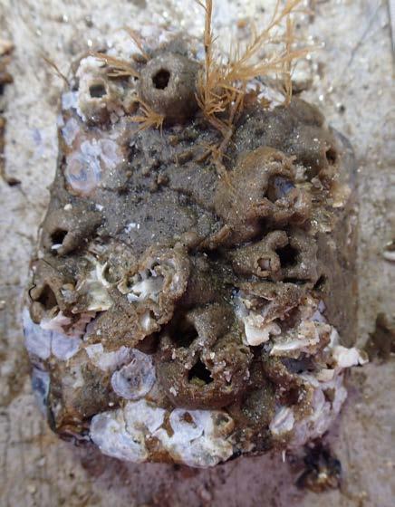
16 Typical surfclam shell (UL), cobble (UR), rock (LL), and boulder (LR) with epibiont free or nearly epibiont free surfaces

17 Differential distribution: barnacles and barnacle scars versus cobbles Cobbles are 2-6 inches across Barnacles were present at nearly all stations and common at most stations Frequently, barnacles were identified as barnacle scars Barnacles were attached to rocks, cobbles, shell, mussels, etc. Circle proportional to bu m -2 for cobbles; occasional (1) and common (2) for barnacles scale differs between data types : cobbles : barnacles/barnacle scars
18 How common are barnacles and barnacle scars? Examined Fraction encrusted Shells % Cobbles % Rocks % Boulders % Total 901 Note that photographic analyses are not normalized to substrate catch volume or by station: numbers are raw estimates based on the number of photographs taken Note that substrate photographs emphasize the side with the most attached epibionts
19 How common are barnacles and barnacle scars? Barnacles Barnacle scars Shells 30.0% 51.4% Cobbles 22.7% 59.6% Rocks 28.6% 73.6% Boulders 26.9% 76.9% What makes a barnacle scar: Dissolution slow relative to settlement/growth Physical abrasion/erosion potentially fast relative to settlement/growth Bioerosion bioeroders of proper size are rare


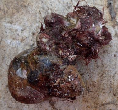
20 Cobbles with barnacles and barnacle scars
 and common (2) for")
21 Assessment strategy: NMFS Delaware II protocol Miscellaneous epibionts: anemones, tunicates, sponges Station tally: sum of occasional (1) and common (2) designations; maximum value = 6 Epibionts rarely encountered: maximum tally = 4 Epibionts very rarely encountered where large surfclams were caught Circle proportional to numbers m -2 for surfclams; sum of occasional (1) and common (2) for attached epibionts scale differs between data types Differential distribution: large surfclams versus epibionts : miscellaneous epibionts : mm surfclams
")
22 Differential distribution: small surfclams versus epibionts Miscellaneous epibionts: anemones, tunicates, sponges Station tally: sum of occasional (1) and common (2) designations; maximum value = 6 Epibionts rarely encountered at any station: maximum tally = 4 Epibionts rarely encountered where small surfclams were caught Circle proportional to numbers m -2 for surfclams; sum of occasional (1) and common (2) for attached epibionts scale differs between data types : miscellaneous epibionts : mm surfclams
23 Comments on attached epibionts: anemones, tunicates, sponges Attached epibionts were rarely encountered and found commonly at very few sites Tunicates were most frequent, with sponges less frequent, and anemones very rare Cobbles, rocks and boulders were usually epibiont free Inference: cobbles, rocks and boulders are rarely exposed; if exposed and colonized, epibionts are rapidly eroded off by prevailing currents/storms; slow growing epibionts have little chance of colonization and growth Cobbles, rocks and boulders offer POOR substrate for colonization by attached species and generate limited habitat potential
24 How common are tunicates, sponges, and anemones? Examined Fraction encrusted Shells % Cobbles % Rocks % Boulders %
25 How common are tunicates, sponges, and anemones? Tunicates Sponges/Anemones Shells 4.8% 0.0% Cobbles 10.1% 1.3% Rocks 7.9% 1.4% Boulders 3.8% 3.8%


26 Examples of he rare large attached epibionts

27 Differential distribution: hydroids versus cobbles Hydroids refer to erect hydroids and bryozoans, likely mostly hydroids Cobbles are 2-6 inches Hydroids were frequently encountered throughout the western twothirds of the surveyed area, including the western half of the HMA Hydroids were attached to cobbles, rocks, boulders, shell, mussels, and various living animals such as gastropods Circle proportional to bu m -2 for cobbles; occasional (1) and common (2) or hydroids scale differs between data types : cobbles : hydroids

28 Differential distribution: hydroids versus large surfclams Hydroids refer to erect hydroids and bryozoans, likely mostly hydroids Hydroids were frequently encountered where large surfclams were found, unlike most other attached epibionts Hydroids were attached to cobbles, rocks, boulders, shell, mussels, and various living animals such as gastropods Circle proportional to numbers m -2 for surfclams; occasional (1) and common (2) for hydroids scale differs between data types : mm surfclams : hydroids
29 Comments on hydroids No effort was made to distinguish erect hydroids and bryozoans, but most were likely hydroids Hydroids were very common at many sites; they attached to any hard substrate including cobbles, rocks, boulders, surfclam shell, other shell, living gastropods, mussels, etc. Hydroids were resistant to erosion either because they grow faster than the frequency of erosive events or their flexibility allows protection Hydroids are the only common epibiont in areas inhabited by large surfclams Hydroids occurred with greater frequency west of the HMA, but were common in the western portion of the HMA
30 How common are hydroids? Examined Fraction encrusted Shells % Cobbles % Rocks % Boulders %


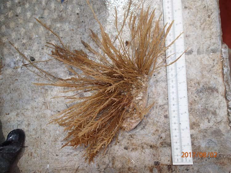
31 Putative hydroids attached to various substrates

32 Differential distribution: large surfclams versus mussels Mussels were Mytilus cf. edulis and Modiolus modiolus Both species often co-occurred in the same bed; both species were characterized by a dispersed sizefrequency including new recruits and adults Mussels were rarely encountered in large numbers; stations yielding large catches were encountered in the northern panhandle and south central portions of the HMA Large surfclams and mussels rarely occurred commonly at the same station scale differs between data types Circle proportional to number m -2 for surfclams; bu m -2 for mussels : mussels : mm surfclams
33 Differential distribution: small surfclams versus mussels Mussels were Mytilus cf. edulis and Modiolus modiolus Both species often co-occurred; both were characterized by a size-frequency including new recruits and adults Mussels were rarely encountered in large numbers; stations yielding large catches were in the northern panhandle and south central portion of the HMA Small surfclams and mussels rarely occurred commonly at the same station scale differs between data types Circle proportional to number m -2 for surfclams; bu m -2 for mussels : mussels : mm surfclams

34 Differential distribution: cobbles versus mussels Mussels were Mytilus cf. edulis and Modiolus modiolus Both species often co-occurred in the same bed Cobbles were 2-6 inches Mussels were rarely encountered in large numbers; stations yielding large catches were in the northern panhandle and south central portion of the HMA Cobbles and mussels sometimes occurred commonly at the same station, but cobbles were not required to support mussel habitation scale differs between data types Circle proportional to bu m -2 for mussels and cobbles : cobbles : mussels

35 Differential distribution: mussels versus rocks Mussels were Mytilus cf. edulis and Modiolus modiolus Both species often co-occurred in the same bed Rocks are 6-12 inches Mussels were rarely encountered in large numbers; stations yielding large catches were in the northern panhandle and south central portion of the HMA Rocks and mussels sometimes occurred commonly at the same station, but rocks were not required to support mussel habitation scale differs between data types Circle proportional to bu m -2 for mussels and rocks : rocks : mussels
36 Comments on mussels Mussels were very common at a number of sites Mussels did not use cobbles, rocks, or boulders as primary habitat; in fact mussels attached to these sedimentary components were collected very rarely Cobbles, rocks and boulders were usually mussel free Inference: cobbles, rocks and boulders are rarely exposed; if exposed and colonized, mussels are rapidly eroded off by prevailing currents/storms Cobbles, rocks and boulders offer POOR substrate for colonization by mussels and generate limited habitat potential Mussels attach primarily to themselves; beds are weighted down by mussel attachment to pea gravel and sand Erosion velocities to suspend and move mats are reported to be knots; such velocities commonly occur in the survey region, suggesting that mussel mat location may shift over time Surfclams rarely overlap with mussels; however, surfclams are moving into deeper water, suggesting that community replacement is occurring with mussels as it is with ocean quahogs.
37 How common is evidence of mussel attachment? Examined Fraction encrusted Shells % Cobbles % Rocks % Boulders %


38 Above, a cobble and a shell with byssal threads attached. Below, a cobble and a rock with mussels attached

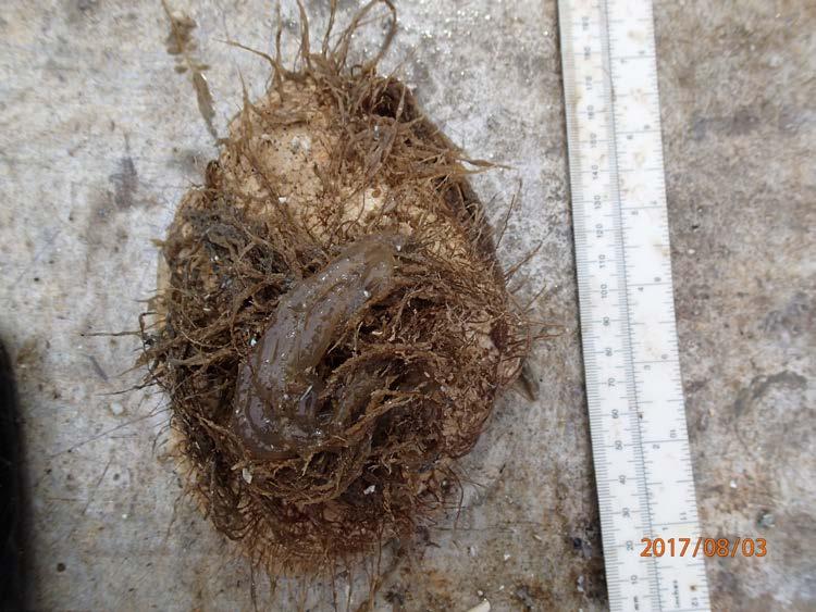
39 A look at the underside of a mussel mat

40 Differential distribution: sea urchins versus mussels Sea urchins were encountered at only a few sites In most cases, these sites were locations where mussels were also found Sea urchins were most common in the central and south central portion of the HMA The occurrence of sea urchins rarely overlapped the occurrence of surfclams Circle proportional to numbers m -2 for sea urchins and bu m -2 for mussels scale differs between data types : mussels : sea urchins
41 Differential distribution: miscellaneous crabs versus mussels Crabs were encountered commonly at only a few sites In most cases, these sites were locations where mussels were also found Crabs were most common in the north central and south central portion of the HMA The occurrence of crabs rarely overlapped the occurrence of surfclams Circle proportional to numbers m -2 for crabs and bu m - 2 for mussels scale differs between data types : mussels : miscellaneous crabs
42 Comments on musselassociated biota Mussels were very common at a number of sites These sites generally supported significant numbers of crabs; sea urchins were frequently encountered Crabs and sea urchins were rarely encountered elsewhere Surfclams rarely overlap with mussels The surveyed region has two primary community types: surfclams and associated sandy biota; mussels and associated mobile epifauna Both are likely in transition as surfclams invade deeper water, potentially displacing mussels Cobbles, rocks, and boulders, though common in the region, do not control or affect community type and location to a significant degree

43 Differential distribution: naticids versus large surfclams Naticid gastropods were encountered commonly at only a few sites These sites were not associated predictably with high surfclam catches or high mussel catches Naticids were most common in the west central portion of the survey region Circle proportional to numbers m -2 for surfclams and naticids scale differs between data types : mm surfclams : naticid gastropods
44 Differential distribution: naticids versus small surfclams Naticid gastropods were encountered commonly at only a few sites These sites were not associated predictably with high catches of small surfclams Naticids were most common in the west central portion of the survey region Circle proportional to numbers m -2 for surfclams and naticids scale differs between data types : mm surfclams : naticid gastropods
45 Naticids are bivalve predators Comments on naticids Naticids occurred predictably throughout the survey region, with high numbers in certain locations These locations were not consistently associated with high surfclam or high mussel catches; in fact, the distribution of naticids was remarkably unpredictable based on observed megabiota Smaller bivalves (e.g., Astarte, Pitar) were commonly observed but not quantified due to low dredge selectivity; these may be naticid prey
Offshore Video Survey and Oceanographic Analysis: Georges Bank to the Chesapeake project
 Non-Technical Synopsis of the Offshore Video Survey and Oceanographic Analysis: Georges Bank to the Chesapeake project Executive Summary Dave Bethoney Kristin Kleisner Mark Anderson Changsheng Chen Bradley
Types of intertidal communities
 Between the tides Marine ecosystems 1 Intertidal Delimited by the highest high tide and the lowest low tides marks The best studied and best-understood by humans Relatively easy to sample compared to other
CLAM DREDGE FRAMEWORK ADJUSTMENT
 New England Fishery Management Council 50 WATER STREET NEWBURYPORT, MASSACHUSETTS 01950 PHONE 978 465 0492 FAX 978 465 3116 John F. Quinn, J.D., Ph.D., Chairman Thomas A. Nies, Executive Director CLAM
Relatively little hard substrate occurs naturally in the
 CHAPTER FIVE Rock Habitats Relatively little hard substrate occurs naturally in the estuary, owing mainly to the vast quantities of fine sediment that have been deposited by the rivers. Rock habitat is
Documenting Plants & Animals in Each Habitat
 Documenting Plants & Animals in Each Habitat STEP 25: UNDERSTAND THE QUADRAT SURVEY METHOD It is not possible to count all the plants and animals in a habitat unit, since the habitat unit could be quite
MEETING SUMMARY. Habitat Plan Development Team March 16, 2018 Providence, RI
 New England Fishery Management Council 50 WATER STREET NEWBURYPORT, MASSACHUSETTS 01950 PHONE 978 465 0492 FAX 978 465 3116 John F. Quinn, J.D., Ph.D., Chairman Thomas A. Nies, Executive Director MEETING
VI) Population and Community Stability
 Population and Community Stability") Proportional abundance VI) Population and Community Stability I. Background / questions - refer back to succession A) Do marine communities trend toward climax states? B) Is there a single climax state?
Proportional abundance VI) Population and Community Stability I. Background / questions - refer back to succession A) Do marine communities trend toward climax states? B) Is there a single climax state?
3 Ecological and Evolutionary Principles. Notes for Marine Biology: Function, Biodiversity, Ecology by Jeffrey S. Levinton
 3 Ecological and Evolutionary Principles Notes for Marine Biology: Function, Biodiversity, Ecology by Jeffrey S. Levinton Ecological hierarchy Population-level processes Individual interactions The Ecological
THE INTERTIDAL ZONE AND BENTHIC ORGANISMS
 THE INTERTIDAL ZONE AND BENTHIC ORGANISMS EPSS 15 Lab #8 OUTLINE I. Intertidal zonation Tides Biotic zonation Physical conditions & biotic interactions II. Intertidal organisms & adaptations Snails Mussels
Larvae survive, grow, develop, disperse. Adult. Juvenile. Rocky Intertidal Ecology
 Rocky Intertidal Ecology Bipartite life cycle of benthic marine organisms with pelagic larvae review I. Population Structure (review) II. Settlement & Recruitment III. Zonation IV. Experiments that changed
MAINTENANCE DREDGE BENTHIC ASSESSMENT SUNSET POINT FARM LLC LONG POINT KEY MONROE COUNTY, FLORIDA. Prepared by:
 MAINTENANCE DREDGE BENTHIC ASSESSMENT SUNSET POINT FARM LLC LONG POINT KEY MONROE COUNTY, FLORIDA Prepared by: December 11, 2016 INTRODUCTION The owners of the Sunset Point Farms LLC, located on the northern
SYDNEY MARINE TERMINAL Second Berth Progress
 SYDNEY MARINE TERMINAL Second Berth Progress Second Berth - Project Proponents Second Berth - Project Partners Second Berth - Key Stakeholder Second Berth Project Components New Second Berth: 1 2 Main
Larvae survive, grow, develop, disperse. Juvenile. Adult. Bipartite life cycle of benthic marine organisms with pelagic larvae. Pelagic Environment
 Bipartite life cycle of benthic marine organisms with pelagic larvae Larvae survive, grow, develop, disperse Rocky Intertidal Pattern: species distributed in discrete zones relative to elevation and tidal
Essentials of Oceanography Eleventh Edition
 Chapter Chapter 1 15 Clickers Lecture Essentials of Oceanography Eleventh Edition Animals of the Benthic Environment Alan P. Trujillo Harold V. Thurman Chapter Overview Benthic communities include a variety
Rocky Intertidal Ecology -- part II The development of experimental ecology. Connell and the experimental revolution
 Rocky Intertidal Ecology -- part II The development of experimental ecology I. Intertidal Zonation, part II 1. Follow ups on Connell 2. Predation 3. Exceptions II. Horizontal Distribution 1. Variation
Brief report on Belize carbonate environments field trip Feb. 2012
 Brief report on Belize carbonate environments field trip Feb. 2012 In february 2012 I travelled to San Pedro (Ambergris Caye) Belize (Figure 1) to examine and study depositional environments of carbonate
VI) Population and Community Stability. VI) Population and Community Stability. I. Background / questions - refer back to succession
 Population and Community Stability. VI) Population and Community Stability. I. Background / questions - refer back to succession") VI) Population and Community Stability I. Background / questions - refer back to succession A) Do marine communities trend toward climax states? B) Is there a single climax state? C) At climax, are populations
VI) Population and Community Stability I. Background / questions - refer back to succession A) Do marine communities trend toward climax states? B) Is there a single climax state? C) At climax, are populations
VI) Population and Community Stability. VI) Population and Community Stability
 Population and Community Stability. VI) Population and Community Stability") VI) Population and Community Stability I. Background / questions - refer back to succession A) Do marine communities trend toward climax states? B) Is there a single climax state? C) At climax, are populations
VI) Population and Community Stability I. Background / questions - refer back to succession A) Do marine communities trend toward climax states? B) Is there a single climax state? C) At climax, are populations
MARINE FISH AND FISH HABITAT COMPONENT STUDY
 Environmental Impact Assessment Component Study MARINE FISH AND FISH HABITAT COMPONENT STUDY Prepared For: Newfoundland and Labrador Refining Corporation 87 Water St Harvey Building, 2 nd Floor St. John
EXTREMELY FAST IP USED TO DELINEATE BURIED LANDFILLS. Norman R. Carlson, Cris Mauldin Mayerle, and Kenneth L. Zonge
 EXTREMELY FAST IP USED TO DELINEATE BURIED LANDFILLS Norman R. Carlson, Cris Mauldin Mayerle, and Kenneth L. Zonge Zonge Engineering and Research Organization, Inc. 3322 East Fort Lowell Road Tucson, Arizona,
Explore Fossils - Past lives of the Kettleman Hills
 Explore Fossils - Past lives of the Kettleman Hills " Explore Fossils " is one of five Virtual Fieldwork Experience (VFE) modules that explores the geology and paleontology of the Kettleman Hills, which
C. STUDENT FIELD DATA SHEETS
 C. STUDENT FIELD DATA SHEETS Student Name Date Time Stream Location Parameter to find Your Group s Results Units trial trial average Transparency cm Water Temperature Air Temperature Weather N sunny N
Environmental Science
 Environmental Science A Study of Interrelationships Cui Jiansheng Hebei University of Science and Technology CH06 Kinds of Ecosystems and Communities Chapter Objectives After reading this chapter, you
Lecture Outline Wednesday - Friday February 14-16, 2018
 Lecture Outline Wednesday - Friday February 14-16, 2018 Quiz 2 scheduled for Friday Feb 23 (Interlude B, Chapters 6,7) Questions? Chapter 6 Pages of the Past: Sedimentary Rocks Key Points for today Be
Geoduck Floating Nursery Monitoring Plan, Quarterly Reporting
 December 23, 2014 Mason County Department of Community Development Attn: Grace Miller, Senior Planner 411 N. Fifth Street PO Box 279 Shelton, WA 98584 Re: Geoduck Floating Nursery Monitoring Plan, Quarterly
Characteristics of Echinoderms
 Characteristics of Echinoderms Adult echinoderms have a body plan with five parts organized symmetrically around a center Does not have an anterior nor posterior end or a brain Most echinoderms are two
SEDAR 42- DW November 2014
 Red Grouper Abundance Indices from NMFS Bottom Longline Surveys in the Northern Gulf of Mexico Adam G. Pollack and G. Walter Ingram, Jr. SEDAR 42- DW- 06 19 November 2014 This information is distributed
FINMARINET: Inventories and Planning for the Marine Natura 2000 Network in Finland. A.2 Geological inventories of the seafloor Final Report
 LIFE07 NAT/FIN/000151 FINMARINET: Inventories and Planning for the Marine Natura 2000 Network in Finland A.2 Geological inventories of the seafloor Final Report Geological Survey of Finland, GTK 1. Introduction
Exercise 3 Texture of siliciclastic sediments
 Exercise 3 Texture of siliciclastic sediments Siliciclastic sediments are derived from the weathering and erosion of preexisting rocks. Once a sedimentary particle is loosened from its parent rock, it
Submersible investigation of unconfirmed western Miami Terrace habitat
 Submersible investigation of unconfirmed western Miami Terrace habitat Prepared By: Brian K. Walker, Ph.D. Nova Southeastern University Oceanographic Center 6/08/2015 On June 5, 2015 Nova Southeastern
Aggregations on larger scales. Metapopulation. Definition: A group of interconnected subpopulations Sources and Sinks
 Aggregations on larger scales. Metapopulation Definition: A group of interconnected subpopulations Sources and Sinks Metapopulation - interconnected group of subpopulations sink source McKillup and McKillup
Larvae survive, grow, develop, disperse. Adult. Juvenile. Bipartite life cycle of benthic marine organisms with pelagic larvae. Pelagic Environment
 Bipartite life cycle of benthic marine organisms with pelagic larvae Larvae survive, grow, develop, disperse In the beginning when ecologists first wandered into the intertidal I. Pattern: species distributed
SW Florida Escarpment Mapping Area
 Overview NOAA s Okeanos Explorer (EX) Program plans to conduct systematic mapping and telepresence-enabled ROV explorations in the Gulf of Mexico during Spring 2014. In 2011, the EX conducted mapping operations
OCEAN ZONES. 1. Intertidal Zone 2. Near-Shore Zone 3. Open-Ocean Zone
 OCEAN ZONES 1. Intertidal Zone 2. Near-Shore Zone 3. Open-Ocean Zone Where the Ocean Meets the Land (Place) Intertidal Zone The intertidal zone is the area between the high- and low-tide lines. At high
OCEAN ZONES. 1. Intertidal Zone 2. Near-Shore Zone 3. Open-Ocean Zone
 OCEAN ZONES 1. Intertidal Zone 2. Near-Shore Zone 3. Open-Ocean Zone Where the Ocean Meets the Land (Place) Intertidal Zone The intertidal zone is the area between the high- and low-tide lines. At high
Bipartite life cycle of benthic marine organisms with pelagic larvae. Larvae. survive, grow, develop, disperse. Pelagic Environment
 Bipartite life cycle of benthic marine organisms with pelagic larvae Larvae survive, grow, develop, disperse reproduce Pelagic Environment Benthic Environment settlement Adult Juvenile survive, grow, mature
Project 1.3.1: Improved knowledge of biota, habitats and risks. Project Leader: Dr Mick Haywood, CSIRO Division of Marine and Atmospheric Research
 Marine and Tropical Sciences Research Facility (MTSRF) June 2007 Milestone Report Project 1.3.1: Improved knowledge of biota, habitats and risks Project Leader: Dr Mick Haywood, CSIRO Division of Marine
Approach to Field Research Data Generation and Field Logistics Part 1. Road Map 8/26/2016
 Approach to Field Research Data Generation and Field Logistics Part 1 Lecture 3 AEC 460 Road Map How we do ecology Part 1 Recap Types of data Sampling abundance and density methods Part 2 Sampling design
BUREAU OF CLEAN WATER. Appendix C Biological Field Methods C1. Habitat Assessment DECEMBER 2013
 BUREAU OF CLEAN WATER Appendix C Biological Field Methods C1. Assessment DECEMBER 2013 HABITAT ASSESSMENT The Department has adopted the habitat assessment methods outlined in EPA s Rapid Bioassessment
DRAFT REPORT. Submitted to: Public Works and Government Services Canada Saint John, New Brunswick
 PWGSC PROJECT #R.078190.002 UNDERWATER BENTHIC HABITAT SURVEY Proposed Construction and Dredge Areas Leonardville DFO-SCH Leonardville, Deer Island, New Brunswick DRAFT REPORT Submitted to: Public Works
V. Urchin Abundance and Size
 V. Urchin Abundance and Size Background The 1983-84 Caribbean-wide mass mortality of the long-spined sea urchin Diadema antillarum represents one of the more spatially expansive and prolonged disturbances
Sediment. Weathering: mechanical and chemical decomposition and disintegration of rock and minerals at the surface
 Sediment Some basic terminology Weathering: mechanical and chemical decomposition and disintegration of rock and minerals at the surface Erosion: removal of weathered rock and minerals from one place to
Habitat Assessment. Peggy Compton UW-Extension Water Action Volunteers Program Coordinator
 Habitat Assessment Peggy Compton UW-Extension Water Action Volunteers Program Coordinator Adapted from a presentation by Jean Unmuth, Water Quality Biologist, WI DNR dnr.wi.gov www.uwex.edu erc.cals.wisc.edu
Form 4 of Schedule 5 of the Exclusive Economic Zone and Continental Shelf (Environmental Effects Permitted Activities) Regulations 2013
 Regulations 2013") FORM 4 Permitted activities: Post-activity report Form 4 of Schedule 5 of the Exclusive Economic Zone and Continental Shelf (Environmental Effects Permitted Activities) Regulations 2013 How to use this
FORM 4 Permitted activities: Post-activity report Form 4 of Schedule 5 of the Exclusive Economic Zone and Continental Shelf (Environmental Effects Permitted Activities) Regulations 2013 How to use this
Cattaraugus Creek: A Story of Flowing Water and the Geology of the Channel It Flows Through Presentation to West Valley Citizen Task Force 4/27/16
 Cattaraugus Creek: A Story of Flowing Water and the Geology of the Channel It Flows Through Presentation to West Valley Citizen Task Force 4/27/16 Raymond C. Vaughan, Ph.D. What happens if you drop a
OCN 201 Spring 2012 Final Exam (75 pts)
") Name ID# Section OCN 201 Spring 2012 Final Exam (75 pts) True or False (1 pt each). A = TRUE; B = FALSE 1. Evidence suggests that amino acids (one of the building blocks of life) can only form under laboratory
Name ID# Section OCN 201 Spring 2012 Final Exam (75 pts) True or False (1 pt each). A = TRUE; B = FALSE 1. Evidence suggests that amino acids (one of the building blocks of life) can only form under laboratory
Geoduck Floating Nursery Monitoring Plan, Quarterly Reporting
 September 27, 2013 Mason County Department of Community Development Attn: Grace Miller, Senior Planner 411 N. Fifth Street PO Box 279 Shelton, WA 98584 Re: Geoduck Floating Nursery Monitoring Plan, Quarterly
1. Which type of climate has the greatest amount of rock weathering caused by frost action? A) a wet climate in which temperatures remain below
 a wet climate in which temperatures remain below") 1. Which type of climate has the greatest amount of rock weathering caused by frost action? A) a wet climate in which temperatures remain below freezing B) a wet climate in which temperatures alternate
1. Which type of climate has the greatest amount of rock weathering caused by frost action? A) a wet climate in which temperatures remain below freezing B) a wet climate in which temperatures alternate
Illustrations of Selected Ordovician fossils
 Illustrations of Selected Ordovician fossils Appendix 1 Brachiopods Cephalopods Brachiopods (brack'-i-oh-pods) are a group of marine animals with two shells. They all have an upper and lower shell. The
Sedimentology & Stratigraphy. Thanks to Rob Viens for slides
 Sedimentology & Stratigraphy Thanks to Rob Viens for slides Sedimentology The study of the processes that erode, transport and deposit sediments Sedimentary Petrology The study of the characteristics and
Mechanical Weathering
 Weathering is the disintegration and decomposition of material at or near the surface. Erosion is the incorporation and transportation of material by a mobile agent, usually water, wind, or ice. Geologists
Yokosuka Cruise Report YK Publicity Cruise collaborating with the museums and. aquariums. Offshore of Izu Peninsula and Sagami Bay
 Yokosuka Cruise Report YK14-22 Publicity Cruise collaborating with the museums and aquariums Offshore of Izu Peninsula and Sagami Bay December 26, 2014 December 29, 2014 Japan Agency for Marine-Earth Science
Modeling Fish Assemblages in Stream Networks Representation of Stream Network Introduction habitat attributes Criteria for Success
 Modeling Fish Assemblages in Stream Networks Joan P. Baker and Denis White Western Ecology Division National Health & Environmental Effects Research Laboratory U.S. Environmental Protection Agency baker.joan@epa.gov
THE DEPOSITS OF TSUNAMIS WESLEY PESANTEZ, CATHERINE NIELD, COLIN WINTER
 THE DEPOSITS OF TSUNAMIS WESLEY PESANTEZ, CATHERINE NIELD, COLIN WINTER AN OVERVIEW OF OUR SEMINAR WHAT IS A TSUNAMI WHY STUDY TSUNAMIS PROPERTIES OF TSUNAMIS TSUNAMI HYDRODYNAMICS IDEALIZED DEPOSITS SEDIMENT
Cowichan Estuary Habitat Mapping and Oyster Population Assessment. Cowichan Stewardship Round Table
 Cowichan Estuary Habitat Mapping and Oyster Population Assessment Presentation at Cowichan Stewardship Round Table June 21, 2018 By Dr. Goetz Schuerholz 1 More than 8000 drone photos taken stitched together
Unit 7: What is an ecosystem?
 Unit 7: What is an ecosystem? Lesson 20 An ecosystem is an area or habitat that contains living and non-living things. The living and non-living things depend on each other in many different ways. An ecosystem
 Page 1 of 9 Name: Base your answer to the question on the diagram below. The arrows show the direction in which sediment is being transported along the shoreline. A barrier beach has formed, creating a
Ch 10 Deposition Practice Questions
 1. Base your answer to the following question on the data table below. Six identical cylinders, A through F, were filled with equal volumes of sorted spherical particles. The data table shows the particle
9693 MARINE SCIENCE. Mark schemes should be read in conjunction with the question paper and the Principal Examiner Report for Teachers.
 CAMBRIDGE INTERNATIONAL EXAMINATIONS Cambridge International Advanced Subsidiary and Advanced Level www.xtremepapers.com MARK SCHEME for the May/June 2015 series 9693 MARINE SCIENCE 9693/02 Paper 2 (AS
The Problem. Which ecosystems are the most sensitive? Where will ecosystems be migrating? Where will investments be overwhelmed?
 BC Parks BC Parks is responsible for the designation, management and conservation of a system of ecological reserves, provincial parks and recreation areas located throughout the province. British Columbia
Figure 1 The map shows the top view of a meandering stream as it enters a lake. At which points along the stream are erosion and deposition dominant?
 1. In which type of climate does chemical weathering usually occur most rapidly? 1. hot and dry 3. cold and dry 2. hot and wet 4. cold and wet 2. Figure 1 The map shows the top view of a meandering stream
Freshwater Mussel Surveys in Mystic Lake and Middle Pond: (Barnstable, Massachusetts)
") REPORT Freshwater Mussel Surveys in Mystic Lake and Middle Pond: 2007-2017 (Barnstable, Massachusetts) prepared for Town of Barnstable 367 Main Street Hyannis, MA 02601 prepared by biodrawversity Biodrawversity
REPORT Freshwater Mussel Surveys in Mystic Lake and Middle Pond: 2007-2017 (Barnstable, Massachusetts) prepared for Town of Barnstable 367 Main Street Hyannis, MA 02601 prepared by biodrawversity Biodrawversity
What Are Coral Reefs?
 ELA.08.CR.1.9.132 C1 T9 Sample Item Id: ELA.08.CR.1.9.132 Grade/Model: 08 / 1b Claim: 1: Students can read closely and analytically to comprehend a range of increasingly complex literary and informational
Name: Period: Date: ID: A. Circle the choice that best completes the statement or answers the question and write the letter on the blank.
 Name: Period: _ Date: _ ID: A Unit 7 Practice Circle the choice that best completes the statement or answers the question and write the letter on the blank. 1. What term describes the movement of rock
Confidence Assessment Scoring System
 Confidence Assessment Scoring System Confidence field Confidence group Confidence question Comments Remote sensing data collection RemoteTechnique Were the techniques used appropriate for the ground type?
RED LIST OF EUROPEAN HABITATS. Marine Results Presentation 24 th May, 2016
 RED LIST OF EUROPEAN HABITATS Marine Results Presentation 24 th May, 2016 Geographical scope of the project Habitat Typology One typology for marine and terrestrial At the same time... revision of EUNIS
CHAPTER 1 INTRODUCTION
 1 CHAPTER 1 INTRODUCTION 1.1 GENERAL Washover sandsheets are often found in low-lying coastal embayment s (Sedgwick and Davis 2003). Washover deposition of marine sand is usually attributed to storm activity
Photo 1: Assen Brothers Splash Dam in 1912, Middle Creek Oregon. Photo courtesy of Coos County Historical Society
 Spatial Correlation of Historical Salmon Spawning Sites to Historical Splash Dam Locations in the Oregon Coast Range By Rebecca Miller Geo 565 Option 2 Final Introduction Photo 1: Assen Brothers Splash
1. Base your answer to the following question on the map below, which shows the generalized bedrock of a part of western New York State.
 1. Base your answer to the following question on the map below, which shows the generalized bedrock of a part of western New York State. 3. The table below describes the deposits that an observer saw while
Introduction: Natural Bridges Setting and Tidepool Habitats
 Introduction: Natural Bridges Setting and Tidepool Habitats 1. Physical setting microcosm of coast- zone influenced by 1) river, 2) waves/tides, 3) wind (NW) Rock Types (wave cut bench) Santa Cruz Mudstone
MOR FOSSILS TEACHERS. Making a Fossil Activity Overview BIG IDEA
 Making a Fossil Activity Overview BIG IDEA OBJECTIVE BACKGROUND Not every organism that died, including dinosaurs, left behind a fossil. Explore fossilization with this activity. Students will follow a
4. The map below shows a meandering stream. Points A, B, C, and D represent locations along the stream bottom.
 1. Sediment is deposited as a river enters a lake because the A) velocity of the river decreases B) force of gravity decreases C) volume of water increases D) slope of the river increases 2. Which diagram
Sediment and Sedimentary rock
 Sediment and Sedimentary rock Sediment: An accumulation of loose mineral grains, such as boulders, pebbles, sand, silt or mud, which are not cemented together. Mechanical and chemical weathering produces
General Geology Lab #4: Sedimentary Rocks and Environments
 Name General Geology Lab #4: Sedimentary Rocks and Environments Please identify the following group of sedimentary rocks. Please determine whether they clastic, biogenic or chemical. Also, answer the sample
Sediment and sedimentary rocks Sediment
 Sediment and sedimentary rocks Sediment From sediments to sedimentary rocks (transportation, deposition, preservation and lithification) Types of sedimentary rocks (clastic, chemical and organic) Sedimentary
Pratice Surface Processes Test
 1. The cross section below shows the movement of wind-driven sand particles that strike a partly exposed basalt cobble located at the surface of a windy desert. Which cross section best represents the
Name. 4. The diagram below shows a soil profile formed in an area of granite bedrock. Four different soil horizons, A, B, C, and D, are shown.
 Name 1. In the cross section of the hill shown below, which rock units are probably most resistant to weathering? 4. The diagram below shows a soil profile formed in an area of granite bedrock. Four different
Beach Pebbles Tell a Story
 Maine Geologic Facts and Localities September, 2000 Text by Joseph T. Kelley, Department of Agriculture, Conservation & Forestry 1 Introduction The smooth, sandy beaches of southern Maine are popular with
Water - most influential force in erosion
 Erosion and Deposition Agents, Forces, and Results What Caused This? What is Erosion? Erosion - moving of rock material from one place to a new location For erosion to occur three processes must take place:
PEI Oyster Monitoring Program Report. Technical Report # 251
 PEI Oyster Monitoring Program 2013 Report Technical Report # 251 PEI Department of Fisheries, Aquaculture and Rural Development Aquaculture Division P.O. Box 1180 548 Main Street Montague, PEI C0A 1R0
Objectives: Define Relative Age, Absolute Age
 S6E5. Students will investigate the scientific view of how the earth s surface is formed. c. Classify rocks by their process of formation. g. Describe how fossils show evidence of the changing surface
Significant Ecological Marine Area Assessment Sheet
 Significant Ecological arine Area Assessment Sheet Name: Eastern Bay of Island Biogenic Soft Sediment Complex Summary: The semi-sheltered areas between the central islands of the Eastern Bay of Islands
Field trip to Racine Reef Complex, Thornton Quarry, Illinois
 Field trip to Racine Reef Complex, Thornton Quarry, Illinois Primary objectives for this fieldtrip 1) Collect and identify the fossils of the Racine Reef Complex. 2) Discuss procedures for collecting fossil
Joint Federal Agency Submerged Aquatic Vegetation Survey Guidance for the New England Region Updated August 11, 2016
 Joint Federal Agency Submerged Aquatic Vegetation Survey Guidance for the New England Region Updated August 11, 2016 FOREWORD This guidance is the result of on-going interagency collaboration between the
Evolution and Life in the Ocean
 Characteristics of All Living Things Contain matter in a highly organized state Capture, store and transmit energy; all organisms require energy Capable of reproduction Change through time and adapt to
The Mollusks. Phylum Mollusca
 The Mollusks Phylum Mollusca Mollusks- Latin molluscus = soft Coelomates Exhibit cephalization Many mollusks have larval stage- trochophore Hatch from egg case Easily dispersed by ocean currents and tides
Serial No. N4567 NAFO SCR Doc. 01/178. SCIENTIFIC COUNCIL MEETING November 2001
 NOT TO BE CITED WITHOUT PRIOR REFERENCE TO THE AUTHOR(S) Northwest Atlantic Fisheries Organization Serial No. N4567 NAFO SCR Doc. 01/178 SCIENTIFIC COUNCIL MEETING November 01 Geographical Distribution
=%REPORT RECONNAISSANCE OF CHISHOLM LAKE PROSPECT. October 25, 1977
 =%REPORT ON FIELD RECONNAISSANCE OF CHISHOLM LAKE PROSPECT October 25, 1977 Bruce D. Vincent Imperial Oil Limited, Minerals - Coal, CALGARY, ALBERTA CHISHOLM LAKE PROSPECT Introduction The Chisholm Lake
Skeletal grains. Pores. Matrix <20 m) Cement. Non-skeletal grains. 1 cm
 Cement. Non-skeletal grains. 1 cm") Components of a Carbonate rock Skeletal grains Pores Matrix
Components of a Carbonate rock Skeletal grains Pores Matrix
Jasper Beach, Machiasport, Maine
 Maine Geologic Facts and Localities June, 2000 Jasper Beach, Machiasport, Maine 44 o 38 30.28 N, 67 o 22 31.96 W Text by Joesph T. Kelley, Department of Agriculture, Conservation & Forestry 1 Map by USGS
3. MARINE HABITAT RESTORATION
 Feasibility Study for Restoration of Titlow Lagoon Fish Passage South Puget Sound Salmon Enhancement Group 3. MARINE HABITAT RESTORATION Marine habitat restoration at Titlow Park could include restoration
Marine biologists have identified over 250,000 marine species. This number is constantly increasing as new organisms are discovered.
 A wide variety of organisms inhabit the marine environment. These organisms range in size from microscopic bacteria and algae to the largest organisms alive today blue whales, which are as long as three
Purbeck Coast Proposed Marine Conservation Zone
 Purbeck Coast Proposed Marine Conservation Zone LB The Purbeck Coast (incorporating intertidal features between Broad Bench and Kimmeridge Bay) has been proposed as a Marine Conservation Zone (pmcz) as
Appendix 10. Habitat Suitability Criteria. Prepared by: Rushing Rivers Institute
 Appendix 10 Habitat Suitability Criteria Prepared by: Rushing Rivers Institute December 2009 Habitat Suitability This appendix describes the details of determining habitat suitability criteria for selected
Great South Channel Habitat Management Area Analysis
 Great South Channel Habitat Management Area Analysis NEFMC Habitat Committee Meeting March 19, 2013 Salem, MA Note that this is the version presented at the meeting modified from version previously posted
What creates a coral reef? Why are corals able to form huge reefs?
 Marine ecosystems 5: Coral Reefs Unique features The foundation of the ecosystem is produced by living things Reef-building corals Similarities with tropical rain forests Richness and complexity 3-dimensional
Jack Sepkoski s Three Great Evolutionary Faunas: Diversity of marine families through time. Revolutions in the History of Life In the Phanerozoic
 Jack Sepkoski s Three Great Evolutionary Faunas: Diversity of marine families through time Soft bodied fauna Revolutions in the History of Life In the Phanerozoic Modern fauna Cambrian fauna Paleozoic
Mussel Powered Living Shorelines for Salt Marsh Erosion Control
 Mussel Powered Living Shorelines for Salt Marsh Erosion Control Laura Whalen Danielle Kreeger David Bushek Angela Padeletti Josh Moody Partnership for the Delaware Estuary Haskin Shellfish Research Lab
17-20 November 2007 Incidental Take Monitoring Methodology and Results
 Sample Site Selection Protocol 17-20 November 2007 Incidental Take Monitoring Methodology and Results On 16 November 2007, the U.S. Fish and Wildlife Service (USFWS) provided the USACE Mobile District
Limitation to qualitative stability indicators. the real world is a continuum, not a dichotomy ~ 100 % 30 % ~ 100 % ~ 40 %
 Stream Stability Assessment & BEHI Surveys Joe Rathbun MDEQ Water Resources Division rathbunj@michigan.gov 517--373 517 373--8868 Stability Stream can transport its water and sediment inputs without changing