HYDROLOGICAL AND HYDRODYNAMIC ASSESSMENT OF KEDARNATH FLOOD. N.N.Rai Director, Central Water Commission, India
|
|
|
- Reginald Taylor
- 5 years ago
- Views:
Transcription
1 HYDROLOGICAL AND HYDRODYNAMIC ASSESSMENT OF KEDARNATH FLOOD by N.N.Rai Director, Central Water Commission, India

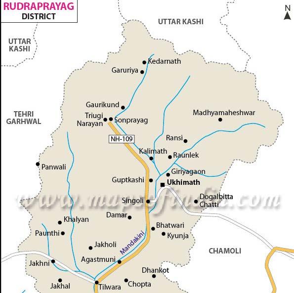

2 Location Map

 recorded 210 mm rainfall in 12 hours during 15 th June 2013 (5:00 PM) and 16 th June")
3 INTRODUCTION Kedarnath Shrine is situated at Lat N and Long E in Garhwal region of Himalyas at an altitude of about 355o masl. On 16 and 17 th June 2013 heavy rains together with Chorabari glacial lake failure caused flooding in Saraswati and Mandakini rivers in Rudraprayag district of Uttarakhand, India. The observatory on Chorabari Glacier Camp (3820 masl) recorded 210 mm rainfall in 12 hours during 15 th June 2013 (5:00 PM) and 16 th June 2013 (5:00 AM). On 16 June 2013 from 5:00 AMto 5:00PM 115 mm rainfall was recorded, total 325 mm rain in 24 hours.
 The India Meteorological Department (IMD) linked heavy to very heavy")

4 Spatial distribution of Rainfall Rainfall (mm) The India Meteorological Department (IMD) linked heavy to very heavy rain-fall on the higher Uttarakhand, Himachal and Nepal Himalaya to the convergence of the Southwest Monsoon trough and westerly disturbances, which led to the formation of dense cloud over the Uttarakhand Himalaya Rainfall (mm)

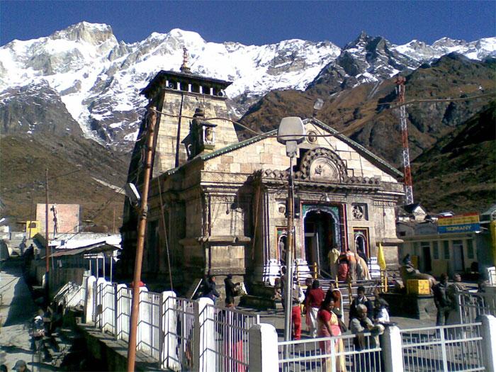
5 Terrain around Kedarnath shrine


6 Event 1 On 16 June 2013 at 5:15PM, the torrential rains flooded the Saraswati River and Dudh Ganga catchment area, resulting in excessive flow across all the channels. The voluminous water studded with debris from the surrounding regions and glacial moraines moved towards Kedarnath town, washing off upper part of the city (Sankaracharya samadhi, Jalnigam guest house, Bharat Seva Sangh Ashram,etc.) and leading to the biggest ever devastation we have seen in the region. Due to heavy downpour, the town of Rambara was completely washed away on 16 June evening.


7 Event 2 The second event occurred on 17 June2013 at 6:45a.m., after overflow and collapse of the moraine dammed Chorabari Lake which released large volume of water that caused another flash flood in the Kedarnath town leading to heavy devastation in Kedarnath and downstream viz Rambara, Gaurikund, Sonprayag, Phata, etc.
8 Event-1: Flood Computations for June 2013 Rainfall Total 24 hr rainfall 325 mm Time Cum % of 24 hr rainfall Time Cum % of 24 hr rainfall
9 Cum % of 24 hr rainfall Time (hour)


10 Kinematic Wave model for Flood Computation Rainfed CA at Rambara-50 sq.km, SF-14 sq.km

11 Peak discharge cumec, Effective 24 hr rainfall 301 mm

12 Peak discharge cumec, Effective 24 hr rainfall 301 mm

13 Peak discharge cumec, Effective 24 hr rainfall 301 mm
 4020 4000 3980 3960 3940 3920 3900 3880 3860 3840 3820 0 100 200 300 400 500 600 Station (m) Legend Ground Bank Sta")
 3440 3420 3400 3380 3360 Legend Ground Bank Sta 3340 0 50 100 150 200 250 300 Station (m) Ked Plan: Plan 01")
14 KD Plan: River = Riverm and3 Reach = 3 RS = 1800 River cross sections from Aster DEM KD Plan: River = Rivermand3 Reach = 3 RS = Ked Plan: Plan 01 River = Mandakini Reach = 1 RS = 5000 Elevation (m) Station (m) Legend Ground Bank Sta Elevation (m) Station (m) Legend Ground Bank Sta Elevation (m) Station (m) Ked Plan: Plan 01 River = Mandakini Reach = 1 RS = 4000 Legend Ground Bank Sta Elevation (m) Legend Ground Bank Sta Station (m) Ked Plan: Plan 01 River = Mandakini Reach = 1 RS = 2000 Elevation (m ) Station (m) Legend Ground Bank Sta

15 Bed Profile of Mandakini river from Kedarnath complex to Rambara
16 Cross section of Mandakini river near Rambara [meter] MANDAKINI /15/2013 5:00:00 PM [meter]
17 Time series of Water level at Rambara Rise in Water level at Rambara about 4.5 m, Flood peak velocity 8.5 m/s [meter] Time Series Water Level Water Level MANDAKINI :00: :00: :00:00 12:00:00 18:00:00 00:00: :00:00 12:00:00
![Time series of Water level at Rambara Rise in Water level at Rambara about 4.5 m, Flood peak velocity 8.5 m/s [meter] Time Series Water Level Water Level 2698.](/docs-images/88/117432028/images/18-0.jpg "5 MANDAKINI 4800.00 2698.0 2697.5 2697.0 2696.5 2696.0 2695.5 2695.0 2694.")
18 Time series of Water level at Rambara Rise in Water level at Rambara about 4.5 m, Flood peak velocity 8.5 m/s [meter] Time Series Water Level Water Level MANDAKINI :00: :00: :00:00 12:00:00 18:00:00 00:00: :00:00 12:00:00
19 Time series of Velocity at Rambara [m/s] Time Series Flow velocity Flow velocity MANDAKINI Velocity :00: :00:00 00:00: :00:00

20 Breach Location of Chorabari Lake Chorabari Glacier Emptied Chorabari Lake Breach Location Source: Bhuvan, NRSC, India

21 MIKE11 mathematical model setup for Glacial lake outburst flood

22 Bed Profile of river from Chorabari lake to Kedarnath Bed profile
23 Chorabari lake outburst flood just d/s of lake location Breach depth 20 m, Breach width (bottom) 40 m, side slope 0.75H:1V Breach development time : 10 minutes [m^3/s] Time Series Discharge Discharge LAKE :00: :00:00 07:00:00 08:00:00
24 Lake outburst flood near Kedarnath complex [m^3/s] Time Series Discharge Discharge :00: :00:00 07:00:00 08:00:00 MANDAKINI
25 Rise in water level near Kedarnath complex due to lake outburst 4.5 m [meter] Time Series Water Level Water Level MANDAKINI :00: :00:00 07:00:00 08:00:00 As per reports water level rise at Kedarnath was about 5 m
26 Lake outburst flood velocity near Kedarnath complex [m/s] Time Series Flow velocity Flow velocity MANDAKINI Velocity :00: :00:00 07:00:00 08:00:00
27 Lake outburst flood hydrograph near Rambara [m^3/s] Time Series Discharge Discharge MANDAKINI :00: :00:00 07:00:00 08:00:00
28 Rise in water level near Rambara due to lake outburst [meter] Time Series Water Level Water Level MANDAKINI :00: :00:00 07:00:00 08:00:00
29 Lake outburst flood velocity near Rambara [m/s] Time Series Flow velocity Flow velocity MANDAKINI Velocity :00: :00:00 07:00:00 08:00:00
30 Conclusion Due to saturated terrain condition because of continuous rain, only two hours consecutive rainfall of intensity about 40 mm/hr was sufficient to create flash flood of the order of 600 cumec. The average slope of the river from Kedarnath up to Rambara is about 160 m/km, which created a shooting flood wave of 4.5 m deep travelling with velocity of about 8.5 m/s, causing devastation of Rambara and some of the portions of Kedarnath on evening of 16 th June The slope of hills near Kedarnath area is about 30 degree from vertical resulting time of concentration of about 1 hronly The Chorabari lake outburst flood was about 1200 cumec, which caused sudden rise is water level by about 5 m near Kedarnath and 6 m near Rambara. This flood wave translated with a shooting velocity of about 10 m/s, resulting complete devastation of Kedarnath, Rambara and other locations.
31 Flood forecast constraints Every year lakhs of people visit Holy Kedarnath shrine during Charodham yatra of Uttarkhand in India This Yatra occurs when monsoon is also active in this part of India, resulting flash floods in steep Himalayan terrain For issuing advanced flood warning in steep hilly terrains of Himalayas, a reliable hourly/three hourly rainfall forecast at least few hours in advance is essential, but the same is a major constraints at present.
32 Thank You
THE UTARAKAHND FLOODS OF JUNE 2013 AND THE KEDARNATH TRAGEDY WHAT COULD HAVE HAPPENED?
 THE UTARAKAHND FLOODS OF JUNE 2013 AND THE KEDARNATH TRAGEDY WHAT COULD HAVE HAPPENED? GEOGRAPHICAL SET UP UTTARAKHAND STATE AREA - 53,484 sq.km FOREST AREA - 34,651 sq.km. (63.93%) HILLY AREA - 46,035
Atmospheric processes leading to extreme flood events
 Atmospheric processes leading to extreme flood events A. P. Dimri School of Environmental Sciences Jawaharlal Nehru University New Delhi, India apdimri@hotmail.com Observational and modelling limitations
LANDSLIDE HAZARD ZONATION IN AND AROUND KEDARNATH REGION AND ITS VALIDATION BASED ON REAL TIME KEDARNATH DISASTER USING GEOSPATIAL TECHNIQUES
 LANDSLIDE HAZARD ZONATION IN AND AROUND KEDARNATH REGION AND ITS VALIDATION BASED ON REAL TIME KEDARNATH DISASTER USING GEOSPATIAL TECHNIQUES Divya Uniyal 1,*, Saurabh Purohit 2, Sourabh Dangwal 1, Ashok
Changing glacial lakes and associated outburst floods risks in Nanda Devi Biosphere Reserve, Indian Himalaya
 Evolving Water Resources Systems: Understanding, Predicting and Managing Water Society Interactions Proceedings of ICWRS2014, Bologna, Italy, June 2014 (IAHS Publ. 364, 2014). 255 Changing glacial lakes
Flood Inundation Mapping under different climate change scenarios in the upper Indus River Basin, Pakistan
 Flood Inundation Mapping under different climate change scenarios in the upper Indus River Basin, Pakistan Sohaib Baig (doctoral student) 16 November 2017 Disaster Prevention Research Institute 1 Kyoto
Chapter 4 Hydrodynamic Modelling of Glacial Lake Outburst Floods
 Chapter 4 Hydrodynamic Modelling of Glacial Lake Outburst Floods To better understand the impacts that a GLOF can have on the downstream valleys, an attempt was made to simulate one GLOF event each in
CASE STUDY NATHPA JHAKRI, INDIA
 SEDIMENT MANAGEMENT CASE STUDY NATHPA JHAKRI, INDIA Key project features Name: Nathpa Jhakri Country: India Category: reduce sediment production (watershed management); upstream sediment trapping; bypass
Remote Sensing and GIS Applications for Hilly Watersheds SUBASHISA DUTTA DEPARTMENT OF CIVIL ENGINEERING IIT GUWAHATI
 Remote Sensing and GIS Applications for Hilly Watersheds SUBASHISA DUTTA DEPARTMENT OF CIVIL ENGINEERING IIT GUWAHATI Deciding Alternative Land Use Options in a Watershed Using GIS Source: Anita Prakash
ENGINEERING HYDROLOGY
 ENGINEERING HYDROLOGY Prof. Rajesh Bhagat Asst. Professor Civil Engineering Department Yeshwantrao Chavan College Of Engineering Nagpur B. E. (Civil Engg.) M. Tech. (Enviro. Engg.) GCOE, Amravati VNIT,
International Journal of Science, Environment and Technology, Vol. 6, No 1, 2017,
 International Journal of Science, Environment and Technology, Vol. 6, No 1, 2017, 493 499 ISSN 2278-3687 (O) 2277-663X (P) Review Article KEDAR TRAGEDY: A CAUSE AND IMPACT ASSESSMENT Dr. Kavita Tariyal
CASE STUDY NATHPA JHAKRI, INDIA
 SEDIMENT MANAGEMENT CASE STUDY NATHPA JHAKRI, INDIA Key project features Name: Nathpa Jhakri Country: India Category: reforestation/revegetation; upstream sediment trapping; bypass channel/tunnel; reservoir
How to manage risk through integrated geohazard assessment. Prof. John M. Reynolds Reynolds International Ltd, Mold, UK
 How to manage risk through integrated geohazard assessment Prof. John M. Reynolds Reynolds International Ltd, Mold, UK Talk outline Introduction Types of disasters within the Himalayas Integrated Geohazard
Rebuilding Flood-Conscious Society
 A zone where strong flood flow or river bank erosion by levee breach are anticipated, which likely to occur collapsing/washing away of house. Set up the joint councils by relative stakeholders(river managers,
CHAPTER 3 REMOTE SENSING & GIS STUDIES
 3.1 INTRODUCTION CHAPTER 3 REMOTE SENSING & GIS STUDIES Remote Sensing (RS) data can be considered an essential data source for the appraisal of natural environments as it provides valuable information
Outline. Remote Sensing, GIS and DEM Applications for Flood Monitoring. Introduction. Satellites and their Sensors used for Flood Mapping
 Outline Remote Sensing, GIS and DEM Applications for Flood Monitoring Prof. D. Nagesh Kumar Chairman, Centre for Earth Sciences Professor, Dept. of Civil Engg. Indian Institute of Science Bangalore 560
Haiti and Dominican Republic Flash Flood Initial Planning Meeting
 Dr Rochelle Graham Climate Scientist Haiti and Dominican Republic Flash Flood Initial Planning Meeting September 7 th to 9 th, 2016 Hydrologic Research Center http://www.hrcwater.org Haiti and Dominican
Nevado Del Ruiz, Lahars
 Nevado Del Ruiz, 1985 - Lahars Lecture Objectives -Basics of lahars: definition, characteristics -Ruiz case study: hazards, impacts Mt. Pinatubo lahar footage by Mike Dolan (MTU) Mt. Pinatubo lahar footage
Report for Area Drainage Studies for 1320 MW (2x660 MW) THERMAL POWER PROJECT AT MIRZAPUR, U.P.
 THERMAL POWER PROJECT AT MIRZAPUR, U.P.") Report for Area Drainage Studies for 1320 MW (2x660 MW) THERMAL POWER PROJECT AT MIRZAPUR, U.P. 1. Introduction M/s Welspun Energy Uttar Pradesh Ltd. (WEUPL) is putting up 1320 MW (2 x 660 MW) coal fired
Report for Area Drainage Studies for 1320 MW (2x660 MW) THERMAL POWER PROJECT AT MIRZAPUR, U.P. 1. Introduction M/s Welspun Energy Uttar Pradesh Ltd. (WEUPL) is putting up 1320 MW (2 x 660 MW) coal fired
Himalayan Tsunami: Disaster Natural But Damage Man-Made
 Himalayan Tsunami: Disaster Natural But Damage Man-Made Dr. Ramesh Chand Associate Professor, Department of Geography, Govt. College Dharampur, Mandi (H.P.) ABSTRACT: Uttarakhand the hill state in the
Report on Disaster statistics of Nepal
 Report on Disaster statistics of Nepal Submitted by Altaf Rehman Submitted to Dr. Naveed Ahmed University of engineering and technology Peshawar Assignment 1 Section A Registration id 14PWCIV456 Page 1
Earth Science Floods
 Non-fiction: Earth Science - Floods Earth Science Floods When dry land is covered by water, we call it a flood. Floods are very dangerous. If they are very bad, homes can be destroyed, and people can die.
A Roundup of Recent Debris Flow Events in Taiwan
 2015 International Workshop on Typhoon and Flood APEC Experience Sharing on Hazardous Weather Events and Risk Management A Roundup of Recent Debris Flow Events in Taiwan Hsiao-Yuan(Samuel) Yin Ph.D. sammya@mail.swcb.gov.tw
Flash Flood Flash Flood Forecasting and Early Warning System (FFEWS)
") Stakeholder Workshop of Haor Area Livelihoods Improvement Project (HALIP) 15 January 2016, Sunamganj, Bangladesh Flash Flood Flash Flood Forecasting and Early Warning System (FFEWS) BUET Study Team Prof
Stakeholder Workshop of Haor Area Livelihoods Improvement Project (HALIP) 15 January 2016, Sunamganj, Bangladesh Flash Flood Flash Flood Forecasting and Early Warning System (FFEWS) BUET Study Team Prof
Regional Flash Flood Guidance and Early Warning System
 WMO Training for Trainers Workshop on Integrated approach to flash flood and flood risk management 24-28 October 2010 Kathmandu, Nepal Regional Flash Flood Guidance and Early Warning System Dr. W. E. Grabs
ESTIMATING SNOWMELT CONTRIBUTION FROM THE GANGOTRI GLACIER CATCHMENT INTO THE BHAGIRATHI RIVER, INDIA ABSTRACT INTRODUCTION
 ESTIMATING SNOWMELT CONTRIBUTION FROM THE GANGOTRI GLACIER CATCHMENT INTO THE BHAGIRATHI RIVER, INDIA Rodney M. Chai 1, Leigh A. Stearns 2, C. J. van der Veen 1 ABSTRACT The Bhagirathi River emerges from
Assessment of the Hood River Delta Hood River, Oregon
 Assessment of the Hood River Delta Hood River, Oregon Pacific Northwest Waterways Association Annual Meeting October 13, 2010 Michael McElwee, Executive Director Port of Hood River Overview U.S. Army Corps
Modelling and Simulation of Floods in Barsa River near Pasakha, Bhutan. Kirtan Adhikari
 Modelling and Simulation of Floods in Barsa River near Pasakha, Bhutan Kirtan Adhikari College of Science and Technology, Rinchending, Royal University of Bhutan Correspondence: adhikari.cst@rub.edu.bt
Natural Disaster Preparedness for Hydropower Projects in High Mountain Environments
 Natural Disaster Preparedness for Hydropower Projects in High Mountain Environments John M. Reynolds Reynolds International Ltd Suite 2, Broncoed House Broncoed Business Park Wrexham Road Mold Flintshire
HYDRAULIC SIMULATION OF FLASH FLOOD AS TRIGGERED BY NATURAL DAM BREAK
 Civil Engineering Forum Volume XXII/1 - January 2013 HYDRAULIC SIMULATION OF FLASH FLOOD AS TRIGGERED BY NATURAL DAM BREAK Yanuar Tri Kurniawan Directorate General of Water Resources, Ministry of Public
Experimental flood early warning system in parts of Beas Basin using integration of weather forecasting, hydrological and hydrodynamic models
 Experimental flood early warning system in parts of Beas Basin using integration of weather forecasting, hydrological and hydrodynamic models Pankaj R. Dhote 1, Praveen K. Thakur 1, S. P. Aggarwal 1, Vimal
GIS as a tool in flood management
 GIS for the United Nations and the International Community Conference Panel: GIS and Capacity - How Territorial Planning Benefits from Geospatial Information 3-5 April 2012 Geneva, Switzerland GIS as a
STUDY GUIDE FOR CONTENT MASTERY. Surface Water Movement
 Surface Water SECTION 9.1 Surface Water Movement In your textbook, read about surface water and the way in which it moves sediment. Complete each statement. 1. An excessive amount of water flowing downslope
Pampanga River Basin Floods (August 06 to 17) Event 1: Southwest Monsoon (Habagat)
 Event 1: Southwest Monsoon (Habagat)") Pampanga River Basin Floods (August 06 to 17) Event 1: Southwest Monsoon (Habagat) Figure 1.0 Satellite Images (above) showing the monsoons rains affecting the western parts of Luzon. Monsoon rains brought
Pampanga River Basin Floods (August 06 to 17) Event 1: Southwest Monsoon (Habagat) Figure 1.0 Satellite Images (above) showing the monsoons rains affecting the western parts of Luzon. Monsoon rains brought
Climate & Climate Change in Indus Basin. How Can Research Help? Danial Hashmi, Pakistan
 Climate & Climate Change in Indus Basin How Can Research Help? Danial Hashmi, Pakistan Sequence of Presentation Brief Description of Indus Basin Climate of Indus Basin Climate of Upper Indus Basin Climate
Floodplain Modeling and Mapping Using The Geographical Information Systems (GIS) and Hec-RAS/Hec-GeoRAS Applications. Case of Edirne, Turkey.
 and Hec-RAS/Hec-GeoRAS Applications. Case of Edirne, Turkey.") Floodplain Modeling and Mapping Using The Geographical Information Systems (GIS) and Hec-RAS/Hec-GeoRAS Applications. Case of Edirne, Turkey. Fuad Hajibayov *1, Basak Demires Ozkul 1, Fatih Terzi 1 1 Istanbul
Floodplain Modeling and Mapping Using The Geographical Information Systems (GIS) and Hec-RAS/Hec-GeoRAS Applications. Case of Edirne, Turkey. Fuad Hajibayov *1, Basak Demires Ozkul 1, Fatih Terzi 1 1 Istanbul
Occurrence of heavy rainfall around the confluence line in monsoon disturbances and its importance in causing floods
 Occurrence of heavy rainfall around the confluence line in monsoon disturbances and its importance in causing floods GNAGESWARA RAO Department of Meteorology & Oceanography, Andhra University, Visakhapatnam
Grant 0299-NEP: Water Resources Project Preparatory Facility
 Document Produced under Grant Project Number: 45206 May 2016 Grant 0299-NEP: Water Resources Project Preparatory Facility Final Report Volume 3 East Rapti (1 of 9) Prepared by Pvt. Ltd. For Ministry of
A study on the heavy rainfall event around Kedarnath area (Uttarakhand) on 16 June 2013
 on 16 June 2013") A study on the heavy rainfall event around Kedarnath area (Uttarakhand) on 16 June 2013 M S Shekhar 1,, S Pattanayak 2, U C Mohanty 2, SPaul 3 and M Sravana Kumar 1 1 Snow & Avalanche Study Establishment,
A study on the heavy rainfall event around Kedarnath area (Uttarakhand) on 16 June 2013 M S Shekhar 1,, S Pattanayak 2, U C Mohanty 2, SPaul 3 and M Sravana Kumar 1 1 Snow & Avalanche Study Establishment,
A STUDY ON HYDRODYNAMIC AND SHORT TERM FLASH FLOOD ANALYSIS OF SURMA RIVER USING DELFT3D MODEL
 Proceedings of the 3 rd International Conference on Civil Engineering for Sustainable Development (ICCESD 2016), 12~14 February 2016, KUET, Khulna, Bangladesh (ISBN: 978-984-34-0265-3) A STUDY ON HYDRODYNAMIC
Flood Forecasting in Bangladesh
 Flood Forecasting in Bangladesh Types of Flood ing Flood ing can be divided into two categories: Flood ing in the rivers caused by upstream rise of river stage as well as rainfall in the basin. Overland
Catastrophic heavy rainfall episode over Uttarakhand during June 2013 observational aspects
 Catastrophic heavy rainfall episode over Uttarakhand during 16 18 June 2013 observational aspects S. D. Kotal*, Soma Sen Roy and S. K. Roy Bhowmik India Meteorological Department, Lodhi Road, New Delhi
Severe Weather Watches, Advisories & Warnings
 Severe Weather Watches, Advisories & Warnings Tornado Watch Issued by the Storm Prediction Center when conditions are favorable for the development of severe thunderstorms and tornadoes over a larger-scale
Figure 1: Rainfall Distribution in the visited affected areas (Source of data: IMD)
") Brief Report on visit to Alaknanda Valley, Uttarakhand Himalaya during 22-24 June 2013 By Surya Parkash, Ph.D. National Institute of Disaster Management, New Delhi A major disaster struck on 16/17 June
Brief Report on visit to Alaknanda Valley, Uttarakhand Himalaya during 22-24 June 2013 By Surya Parkash, Ph.D. National Institute of Disaster Management, New Delhi A major disaster struck on 16/17 June
International Journal of IT, Engineering and Applied Sciences Research (IJIEASR) ISSN: Volume 2, No. 11, November 2013
 ISSN: Volume 2, No. 11, November 2013") 1 Effect of Climate Change on Out-migration in Uttarakhand: A Statistical Analysis based on Cox-proportional Hazard Model for Kimsar Area and Rajaji National Park N. K. Kamboj, Research Scholar, Department
1 Effect of Climate Change on Out-migration in Uttarakhand: A Statistical Analysis based on Cox-proportional Hazard Model for Kimsar Area and Rajaji National Park N. K. Kamboj, Research Scholar, Department
CIVIL ENGINEERING. Engineering Hydrology RIB-R T11 RIB. Detailed Explanations. Rank Improvement Batch ANSWERS. RIB(R)-18 CE Engineering Hydrology
-18 CE Engineering Hydrology") RIB-R T11 RIB Rank Improvement Batch Session 18-1 S.No. : 118_SK CIVIL ENGINEERING Engineering Hydrology ANSWERS 1. (b) 7. (c) 1. (c) 1. (b). (d). (c) 8. (a) 1. (a). (b). (c). (a). (d) 1. (c) 1. (a) 7.
RIB-R T11 RIB Rank Improvement Batch Session 18-1 S.No. : 118_SK CIVIL ENGINEERING Engineering Hydrology ANSWERS 1. (b) 7. (c) 1. (c) 1. (b). (d). (c) 8. (a) 1. (a). (b). (c). (a). (d) 1. (c) 1. (a) 7.
3. HYDROMETEROLOGY. 3.1 Introduction. 3.2 Hydro-meteorological Aspect. 3.3 Rain Gauge Stations
 3. HYDROMETEROLOGY 3.1 Introduction Hydrometeorology is a branch of meteorology and hydrology that studies the transfer of water and energy between the land surface and the lower atmosphere. Detailed hydrological
Prediction of landslide-induced debris flow hydrograph: the Atsumari debris flow disaster in Japan
 Monitoring, Simulation, Prevention and Remediation of Dense and Debris Flows 27 Prediction of landslide-induced debris flow hydrograph: the Atsumari debris flow disaster in Japan H. Takaoka 1, H. Hashimoto
Solution: The ratio of normal rainfall at station A to normal rainfall at station i or NR A /NR i has been calculated and is given in table below.
 3.6 ESTIMATION OF MISSING DATA Data for the period of missing rainfall data could be filled using estimation technique. The length of period up to which the data could be filled is dependent on individual
GLACIAL LAKE OUTBURST FLOODS IN THE NEPAL HIMALAYA JONATHAN M LALA UNIVERSITY OF TEXAS AT AUSTIN CE 394K.3 GIS IN WATER RESOURCES DECEMBER 2, 2016
 GLACIAL LAKE OUTBURST FLOODS IN THE NEPAL HIMALAYA JONATHAN M LALA UNIVERSITY OF TEXAS AT AUSTIN CE 394K.3 GIS IN WATER RESOURCES DECEMBER 2, 2016 TABLE OF CONTENTS Abstract... 3 Introduction... 3 Methods...
Engineering Hydrology
 Engineering Hydrology Prof. Rajesh Bhagat Asst. Professor Civil Engineering Department Yeshwantrao Chavan College Of Engineering Nagpur B. E. (Civil Engg.) M. Tech. (Enviro. Engg.) GCOE, Amravati VNIT,
Waterbury Dam Disturbance Mike Fitzgerald Devin Rowland
 Waterbury Dam Disturbance Mike Fitzgerald Devin Rowland Abstract The Waterbury Dam was completed in October 1938 as a method of flood control in the Winooski Valley. The construction began in April1935
Practical aspects of dam break analysis
 Practical aspects of dam break analysis Louis C Hattingh Hattingh Anderson Associates CC Dam break analysis It is a model You need to understand what you model & have an idea of the answers that you expect
9. Flood Routing. chapter Two
 9. Flood Routing Flow routing is a mathematical procedure for predicting the changing magnitude, speed, and shape of a flood wave as a function of time at one or more points along a watercourse (waterway
INTERNATIONAL JOURNAL OF GEOMATICS AND GEOSCIENCES Volume 6, No 2, 2015
 INTERNATIONAL JOURNAL OF GEOMATICS AND GEOSCIENCES Volume 6, No 2, 2015 Copyright by the authors - Licensee IPA- Under Creative Commons license 3.0 Research article ISSN 0976 4380 Simulation and modeling
8 Current Issues and Research on Sediment Movement in the River Catchments of Japan
 8 Current Issues and Research on Sediment Movement in the River Catchments of Japan YUTAKA ICHIKAWA INTRODUCTION Prediction of sediment movement is one of the challenging tasks in water-related research.
Monitoring and Analysis of CloudBurst Region using Geomantic Techniques
 Monitoring and Analysis of CloudBurst Region using Geomantic Techniques V.V.Govind Kumar 1 and Dr. Kamal Jain 2 1,2 Department of Civil engineering, Indian Institute of Technology Roorkee-247667, India
A Comparative Study of Uttarakhand and Kashmir Flood in the plight of Natural Disaster
 Volume-7, Issue-4, July-August 2017 International Journal of Engineering and Management Research Page Number: 443-450 A Comparative Study of Uttarakhand and Kashmir Flood in the plight of Natural Disaster
Recent extreme weather events in the Nepal Himalayas
 The Extremes ofthe Extremes: Extraordinary Floods (Proceedings of n symposium held al Reykjavik. Iceland. July 2000). lalispubl.no. 271. 2002. 141 Recent extreme weather events in the Nepal Himalayas SURESH
HYDRO-METEOROLOGICAL INVESTIGATION OF 2015 FLASH FLOOD IN EASTERN HILL BASIN BANGLADESH
 HYDRO-METEOROLOGICAL INVESTIGATION OF 2015 FLASH FLOOD IN EASTERN HILL BASIN BANGLADESH M.S. Hossain 1*, G. M. T. Islam 2, S. U. Raihan 1, S. M. Q. Hassan 3 & R. H. Khan 4 1 Flood Forecasting and Warning
South Asia Flash Flood Guidance System Operational Workshop (Step-4)
") South Asia Flash Flood Guidance System Operational Workshop (Step-4) (5 th to 7 th June 2018) Operational Flash Flood Forecasting and Early Warnings Capabilities in Bhutan (Sonam Tashi) Weather Forecaster
South Asia Flash Flood Guidance System Operational Workshop (Step-4) (5 th to 7 th June 2018) Operational Flash Flood Forecasting and Early Warnings Capabilities in Bhutan (Sonam Tashi) Weather Forecaster
Down-stream process transition (f (q s ) = 1)
 = 1)") Down-stream process transition (f (q s ) = 1) Detachment Limited S d >> S t Transport Limited Channel Gradient (m/m) 10-1 Stochastic Variation { Detachment Limited Equilibrium Slope S d = k sd A -θ d S
Down-stream process transition (f (q s ) = 1) Detachment Limited S d >> S t Transport Limited Channel Gradient (m/m) 10-1 Stochastic Variation { Detachment Limited Equilibrium Slope S d = k sd A -θ d S
Advanced /Surface Hydrology Dr. Jagadish Torlapati Fall 2017 MODULE 2 - ROUTING METHODS
 Routing MODULE - ROUTING METHODS Routing is the process of find the distribution of flow rate and depth in space and time along a river or storm sewer. Routing is also called Flow routing or flood routing.
Report of the 2013 BE expedition to observe climate change in the Himalayas
 Report of the 2013 BE expedition to observe climate change in the Himalayas Introduction scientific leader, John Griffiths (Meteogroup) In the summer of 2013 British Exploring (BE) organised and ran a
DISASTER HAZARDS IN BHUTAN By Tshewang Rinzin January Reducing Disaster Risks for a Safe and Happy Bhutan
 DISASTER HAZARDS IN BHUTAN By Tshewang Rinzin 26-27 January 2009 Reducing Disaster Risks for a Safe and Happy Bhutan Disaster Hazards in Bhutan Earthquakes Glacial Lake Outburst Flood (GLOF) Floods in
What Are Disasters? The Rescue Kids Trio!
 The Rescue Kids Trio! What Are Disasters? This manual was made possible through funding by the Council of Local Authorities for International Relations. Disasters and emergency preparedness Emergency preparedness
SEVERE WEATHER 101. Flood Basics
 SEVERE WEATHER 101 Flood Basics What is flooding? Flooding is an overflowing of water onto land that is normally dry. Floods can happen during heavy rains, when ocean waves come on shore, when snow melts
INTERNATIONAL JOURNAL OF GEOMATICS AND GEOSCIENCES Volume 2, No 2, 2011
 INTERNATIONAL JOURNAL OF GEOMATICS AND GEOSCIENCES Volume 2, No 2, 2011 Copyright 2010 All rights reserved Integrated Publishing services Research article ISSN 0976 4380 Geomorphological study of Atagad
OIKOS > landslide > mechanism >predisposing causes
 predisposing causes and trigger OIKOS > landslide > mechanism >predisposing causes Landslides are events that occur in space and time. As such, it is usually possible to identify both one or more landslide
INTERNATIONAL JOURNAL OF PURE AND APPLIED RESEARCH IN ENGINEERING AND TECHNOLOGY
 INTERNATIONAL JOURNAL OF PURE AND APPLIED RESEARCH IN ENGINEERING AND TECHNOLOGY A PATH FOR HORIZING YOUR INNOVATIVE WORK ASSESSMENT OF RESERVOIR SEDIMENTATION IN PANSHET RESERVOIR BY HYBRID METHOD N.
The Application of Sabo Technology for Lahars Flood Mitigation and Warning System in Volcanic Area. Agus Sumaryono Bambang Sukatja F.
 The Application of Sabo Technology for Lahars Flood Mitigation and Warning System in Volcanic Area Agus Sumaryono Bambang Sukatja F. Tata Yunita BACKGROUND The Indonesia Government has constructed several
FOREST RESEARCH INSTITUTE, DEHRADUN
 PROJECT REPORT DRAINAGE AND REPLENISHMENT STUDY OF MINED AREA OF GANGA SHYAMPUR RIVER HARIDWAR Submitted to UTTARAKHAND FOREST DEVELOPMENT CORPORATION (UFDC) 73, Nehru Road, Deharadun Prepared&Submitted
FLOOD HAZARD MAPPING OF DHAKA-NARAYANGANJ-DEMRA (DND) PROJECT USING GEO-INFORMATICS TOOLS
 PROJECT USING GEO-INFORMATICS TOOLS") FLOOD HAZARD MAPPING OF DHAKA-NARAYANGANJ-DEMRA (DND) PROJECT USING GEO-INFORMATICS TOOLS Md. Aminul Islam MEE07178 Supervisor: Prof. Kuniyoshi TAKEUCHI ABSTRACT Dhaka-Narayanganj-Demra (DND) Project is
FLOOD HAZARD MAPPING OF DHAKA-NARAYANGANJ-DEMRA (DND) PROJECT USING GEO-INFORMATICS TOOLS Md. Aminul Islam MEE07178 Supervisor: Prof. Kuniyoshi TAKEUCHI ABSTRACT Dhaka-Narayanganj-Demra (DND) Project is
GENERAL. CHAPTER 1 BACKGROUND AND PURPOSE OF THE GUIDELINES Background of the Guidelines Purpose of the Guidelines...
 GENERAL CHAPTER 1 BACKGROUND AND PURPOSE OF THE GUIDELINES... 1 1.1 Background of the Guidelines... 1 1.2 Purpose of the Guidelines... 3 CHAPTER 2 APPLICATION OF THE GUIDELINES... 3 2.1 Potential Users
Hydro-engineers.ch HEC-RAS ANALAYSIS. River: L Aïre Mesfin Tewolde. Hydro-engineers.ch 23 oct. 2017
 Hydro-engineers.ch HEC-RAS ANALAYSIS River: L Aïre Mesfin Tewolde 17 Hydro-engineers.ch 23 oct. 2017 PREPARED BY MESFIN TEWOLDE [TEMPORARY MISSION] Hydro-engineers.ch HEC-RAS ANALYSIS [January- March 2014]
International Journal Of Scientific & Engineering Research, Volume 7, Issue 7, July ISSN
 International Journal Of Scientific & Engineering Research, Volume 7, Issue 7, July-2016 709 FLOOD MITIGATION STUDY IN ADAYAR RIVER USING MIKE-FLOOD Vidyapriya.V a and Ramalingam. M b a Research scholar,
Flood Hazard Vulnerability Mapping Using Remote Sensing and GIS: A Case Study of Surat Dhruvesh KM 1*, Praful MU 2 and Aditya MV 1 1
 Flood Hazard Vulnerability Mapping Using Remote Sensing and GIS: A Case Study of Surat Dhruvesh KM 1*, Praful MU 2 and Aditya MV 1 1 CU Shah University, Wadhwan, India 2 ISTAR-CVM, Vallabh Vidyanagar,
FFGS Additional Functionalities and Products. Konstantine P. Georgakakos, Sc.D. HYDROLOGIC RESEARCH CENTER 23 May 2018
 FFGS Additional Functionalities and Products Konstantine P. Georgakakos, Sc.D. HYDROLOGIC RESEARCH CENTER 23 May 2018 Advanced Functionalities 0. Multi-Model QPF A. Urban Flash Flood Warning B. Riverine
Beaver Creek Corridor Design and Analysis. By: Alex Previte
 Beaver Creek Corridor Design and Analysis By: Alex Previte Overview Introduction Key concepts Model Development Design Accuracy Conclusion Refresh v = Beaver Creek Site = Wittenberg Introduction Low head
The Impact of 2007 Atlantic Hurricane Season on Dominica
 The Impact of 2007 Atlantic Hurricane Season on Dominica DOMINICA November 2007 Main Activities Freak Twister on June 21st 2007. Hurricane Dean on August 16th to 17th 2007 Active Tropical Wave on September
Disaster RISK Management : Bhutanese Scenario
 Disaster RISK Management : Bhutanese Scenario Expert Group Meeting (EGM) on Geo-referenced Information Systems for Disaster Risk Management (Geo-DRM) and sustaining the Community of Practice (COP), Bangkok,
Rainfall is the major source of water for
 RESEARCH PAPER: Assessment of occurrence and frequency of drought using rainfall data in Coimbatore, India M. MANIKANDAN AND D.TAMILMANI Asian Journal of Environmental Science December, 2011 Vol. 6 Issue
GEOMORPHIC CHANGES OF A LANDSLIDE DAM BY OVERTOPPING EROSION
 DOI: 10.4408/IJEGE.2011-03.B-087 GEOMORPHIC CHANGES OF A LANDSLIDE DAM BY OVERTOPPING EROSION K. Yoshino (*), T. Uchida (*), T. shimizu (*) & K. Tamura (*) (*) Incorporated Administrative Agency, Public
WATERCOURSE HARNESSING BANK EROSION AND CONSOLIDATION
 GUVERNUL MINISTERUL POSDRU MUNCII, FAMILIEI ŞI WATERCOURSE HARNESSING BANK EROSION AND CONSOLIDATION PhD. student: ALUPOAE Daniel Gheorghe Asachi Technical University of Iasi, Faculty of Civil Engineering
Hydrographical Surveying of the Subaqueous Delta Plain of the River Rhine at Lake Constance
 Hydrographical Surveying of the Subaqueous Delta Plain of the River Rhine at Lake Constance Erwin Heine Institute of Surveying BOKU University Vienna, AUSTRIA Content Introduction Universität für Bodenkultur
Great Lakes Tributary Modeling: Canaseraga Creek Watershed
 Great Lakes Tributary Modeling: Canaseraga Creek Watershed SWAT Model Authority: Section 516(e) of WRDA 1996 US Army Corps of Engineers Canaseraga Creek Project Location - Encompasses portions of Livingston,
SECTION II Hydrological risk
 Chapter 3 Understanding disaster risk: hazard related risk issues SECTION II Hydrological risk Peter Salamon Coordinating lead author Hannah Cloke Lead author 3.4 Giuliano di Baldassarre Owen Landeg Florian
Dam Break Analysis Using HEC-RAS and HEC-GeoRAS A Case Study of Ajwa Reservoir
 Journal of Water Resources and Ocean Science 2016; 5(6): 108-113 http://www.sciencepublishinggroup.com/j/wros doi: 10.11648/j.wros.20160506.15 ISSN: 2328-7969 (Print); ISSN: 2328-7993 (Online) Case Report
Role of Hydro-Met Services in Disaster Risk Management
 Role of Hydro-Met Services in Disaster Risk Management Tshewang Rigzin (Mr) National Centre for Hydrology and Meteorology, Bhutan 30 th November 2017 Outline Vision and Mission Functions related to Disaster
Assessment of the catastrophic events originated in the river Vere basin
 Assessment of the catastrophic events originated in the river Vere basin Tbilisi, Georgia Presenter: Irakli Megrelidze Deputy Head of Hydrometeorological Department (National Environmental Agency) Hydrology
MONITORING OF SEASONAL SNOW COVER IN YAMUNA BASIN OF UTTARAKAHND HIMALAYA USING REMOTE SENSING TECHNIQUES
 MONITORING OF SEASONAL SNOW COVER IN YAMUNA BASIN OF UTTARAKAHND HIMALAYA USING REMOTE SENSING TECHNIQUES Anju Panwar, Devendra Singh Uttarakhand Space Application Centre, Dehradun, India ABSTRACT Himalaya
Striving Sufficient Lead Time of Flood Forecasts via Integrated Hydro-meteorological Intelligence
 Striving Sufficient Lead Time of Flood Forecasts via Integrated Hydro-meteorological Intelligence Dong-Sin Shih Assistant Professor, National Chung Hsing University, Taiwan, Sep. 6, 2013 Outlines Introductions
APPROACH TO THE SPANISH WATER ORGANISATION IMPROVING FLOOD HAZARD MAPPING, LAWS AND AUTHORITIES COORDINATION
 "Workshop On Land Use Planning And Water Management, With Focus On Flood Risk Management Oslo, Norway. Wednesday 31 January and Thursday 1 February 2007 APPROACH TO THE SPANISH WATER ORGANISATION IMPROVING
Hydro-meteorological Analysis of Langtang Khola Catchment, Nepal
 Hydro-meteorological Analysis of Langtang Khola Catchment, Nepal Tirtha R. Adhikari 1, Lochan P. Devkota 1, Suresh.C Pradhan 2, Pradeep K. Mool 3 1 Central Department of Hydrology and Meteorology Tribhuvan
Tarbela Dam in Pakistan. Case study of reservoir sedimentation
 Tarbela Dam in Pakistan. HR Wallingford, Wallingford, UK Published in the proceedings of River Flow 2012, 5-7 September 2012 Abstract Reservoir sedimentation is a main concern in the Tarbela reservoir
Current Rainfall of September 17, 2018 and Three Days Forecast for Rapti River Basin
 FLOOD MANAGEMENT INFORMATION SYSTEM CENTRE IRRIGATION & WATER RESOURCE DEPARTMENT, LUCKNOW Current Rainfall of September 17, 2018 and Three Days Forecast for Rapti River Basin Current Status Rainfall Summary
Erosion Surface Water. moving, transporting, and depositing sediment.
 + Erosion Surface Water moving, transporting, and depositing sediment. + Surface Water 2 Water from rainfall can hit Earth s surface and do a number of things: Slowly soak into the ground: Infiltration
Attabad landslide crisis in Hunza, Pakistan lessons for the management of valley blocking landslides. Dave Petley
 Attabad landslide crisis in Hunza, Pakistan lessons for the management of valley blocking landslides Dave Petley Durham University, United Kingdom Thanks to: D. Karim, S. Wali, N. Ali, N. Nasab & K. Shaban
River Inundation and Hazard Mapping a Case Study of North Zone Surat City
 River Inundation and Hazard Mapping a Case Study of North Zone Surat City Patel Chandresh G, Assistant Professor, Ganpat University, Kherva Dr.P.J. Gundaliya, Associate Professor, LDCE, Ahmedabad Abstract:
DETECTION AND FORECASTING - THE CZECH EXPERIENCE
 1 STORM RAINFALL DETECTION AND FORECASTING - THE CZECH EXPERIENCE J. Danhelka * Czech Hydrometeorological Institute, Prague, Czech Republic Abstract Contribution presents the state of the art of operational
Current Rainfall of September 29, 2018 and Three Days Forecast for Rapti River Basin
 FLOOD MANAGEMENT INFORMATION SYSTEM CENTRE IRRIGATION & WATER RESOURCE DEPARTMENT, LUCKNOW Current Rainfall of September 29, 2018 and Three Days Forecast for Rapti River Basin Current Status Rainfall Summary