New Mexico Geological Society
|
|
|
- Duane Ford
- 5 years ago
- Views:
Transcription

1 New Mexico Geological Society Downloaded from: Tectonic significance of the Pony Hills, Luna County, New Mexico LeRoy L. Corbitt and Fred L. Nials, 1975, pp in: Las Cruces Country, Seager, W. R.; Clemons, R. E.; Callender, J. F.; [eds.], New Mexico Geological Society 26 th Annual Fall Field Conference Guidebook, 376 p. This is one of many related papers that were included in the 1975 NMGS Fall Field Conference Guidebook. Annual NMGS Fall Field Conference Guidebooks Every fall since 1950, the New Mexico Geological Society (NMGS) has held an annual Fall Field Conference that explores some region of New Mexico (or surrounding states). Always well attended, these conferences provide a guidebook to participants. Besides detailed road logs, the guidebooks contain many well written, edited, and peer-reviewed geoscience papers. These books have set the national standard for geologic guidebooks and are an essential geologic reference for anyone working in or around New Mexico. Free Downloads NMGS has decided to make peer-reviewed papers from our Fall Field Conference guidebooks available for free download. Non-members will have access to guidebook papers two years after publication. Members have access to all papers. This is in keeping with our mission of promoting interest, research, and cooperation regarding geology in New Mexico. However, guidebook sales represent a significant proportion of our operating budget. Therefore, only research papers are available for download. Road logs, mini-papers, maps, stratigraphic charts, and other selected content are available only in the printed guidebooks. Copyright Information Publications of the New Mexico Geological Society, printed and electronic, are protected by the copyright laws of the United States. No material from the NMGS website, or printed and electronic publications, may be reprinted or redistributed without NMGS permission. Contact us for permission to reprint portions of any of our publications. One printed copy of any materials from the NMGS website or our print and electronic publications may be made for individual use without our permission. Teachers and students may make unlimited copies for educational use. Any other use of these materials requires explicit permission.
2 This page is intentionally left blank to maintain order of facing pages.
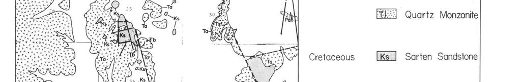
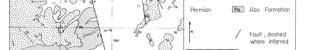
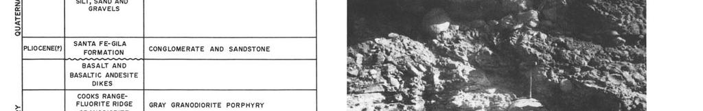
3 New Mexico Geol. Soc. Guidebook, 26th Field Conf., Las Cruces Country, TECTONIC SIGNIFICANCE OF THE PONY HILLS, LUNA COUNTY, NEW MEXICO by LeROY L. CORBITT and FRED L. NIALS Eastern New Mexico University Portales, New Mexico INTRODUCTION The Pony Hills are in the Mexican Highlands section of the Basin and Range province in north-central Luna County, New Mexico about 12 mi northeast of Deming between Cookes Range and Fluorite Ridge (Fig. 1). Some of the major structures and stratigraphic features of the area were observed by Darton (1916, 1917) during mapping for the Deming Folio. Jicha (1954) and Elston (1957) mapped the northern part of Cookes Range. Griswold (1961) mapped and described the geology of Fluorite Ridge. The state geologic map (Dane and Bachman, 1961) follows Darton's interpretation of the geology in the Pony Hills area. Financial support for this report was provided by Eastern New Mexico Institutional Research funds. PREVIOUS WORK Darton (1916, 1917) mapped the Pony Hills (Fig. 1) as several blocks of Precambrian granite in fault contact with the Cretaceous Sarten Sandstone and surrounded by Quaternary bolson deposits. Darton also mapped several outcrops of Precambrian granite exposed through Tertiary agglomerates one mile southwest of the Pony Hills along the northeast flank of Fluorite Ridge. Griswold (1961, p. 100) noted that these outcrops appear to be zones within the Gila (?) conglomerate containing an abundance of Precambrian lithologies and suggested a similar origin for Precambrian lithologies in the Pony Hills. Griswold also described three small patches of conglomerate composed entirely of subrounded Precambrian rock fragments contained in a highly ferruginous matrix and intruded by granodiorite porphyry on Fluorite Ridge. PRESENT WORK Detailed mapping in the Pony Hills area indicates that all the areas previously mapped as Precambrian outcrop are actually Tertiary (Eocene?) andesitic fanglomerates and mudflows containing large clasts of Precambrian and Paleozoic rocks. The soft andesitic matrix has been selectively removed leaving a residual lag gravel that appears to be outcrop when in fault contact with the Sarten Sandstone. The sedimentary con, tact between the Sarten Sandstone and the overlying andesitic conglomerate is best seen in the southern part of sec. 25, T. 21 S., R. 9 W. (Fig. 2). STRATIGRAPHY The stratigraphy of the Pony Hills area is summarized in Figure 3. The Abo Formation consists of interbedded limestone, limestone conglomerate, chert-breccia conglomerate, and red shale and siltstone. The best exposure is along the axis of Goat Ridge about three miles west of the Pony Hills where 100 to 200 ft of the Abo Formation are exposed beneath the Sarten Sandstone. Basal Abo strata are not exposed along Goat Ridge. However, the Abo overlies a thin Pennsylvanian section to the north in Cookes Range where Kottlowski (1958, p. 84) reported angular fragments of Precambrian igneous and metamorphic lithologies in the Abo, indicating nearby uplift and erosion of the Precambrian during Wolfcampian time. Uplift of this magnitude is not indicated by the Abo Formation in the Pony Hills area; here it appears to be a landward facies of the massive Hueco Limestone exposed to the south in the Florida Mountains. The Sarten Sandstone unconformably overlies the Abo Formation and consists of a basal chert-breccia conglomerate overlain by buff to gray, thin- to medium-bedded sandstone; it is about 300 ft thick along Sarten Ridge one mile east of the Pony Hills. The Sarten Sandstone is unconformably overlain by the Rubio Peak Formation (?) which consists of andesite, andesitic fanglomerate, mudflows and in some areas a basal red bed conglomerate unit, which appears to be equivalent to the Lobo Formation in the Florida Mountains and to the Love Ranch Formation in the San Andres Mountains. The best exposure of the lower unit is 2 mi north of the Pony Hills in sec. 11, T. 21 S., R. 9 W., where it consists of red shale, sandstone and conglomerate (Fig. 4) containing clasts of Precambrian rocks up to 3 ft in diameter. There the strata are highly lenticular, appear to be fluvial in origin, and are overlain by reworked andesitic material. The three outcrops described by Griswold (1961) on Fluorite Ridge, which consist of Precambrian clasts in a highly ferruginous matrix and intruded by granodiorite, appear to be equivalent to the above described red beds and conglomerate. In the Pony Hills, the Sarten Sandstone is overlain by andesitic fanglomerate (Fig. 5) and mudflows (Fig. 6) containing Precambrian and Paleozoic clasts up to 10 ft in diameter (Fig. 7). The soft matrix has been selectively removed, leaving a residual pile of boulders which locally appear to be rooted outcrops when in fault contact with the Sarten Sandstone. The andesitic material ranges from relatively clean reworked purplish tuff to fanglomerate and mudflows containing various mixtures and sizes of Precambrian and Paleozoic lithologies. The largest Precambrian blocks appear to be concentrated near the Pony Hills (Fig. 7). Immediately northwest of the Pony Hills, Paleozoic boulders predominate over Precambrian. North of Fluorite Ridge the clasts are mostly Precambrian. Between Fluorite Ridge and Goat Ridge about 100 ft of andesitic material containing no clasts is exposed below the boulder beds. Boulder beds are absent in the andesite exposed about one mile northeast of the Pony Hills. One mile southeast of the Pony Hills, Precambrian and Paleozoic clasts are highly mixed. The best exposure of the andesitic unit is in an arroyo 2 mi east of the Pony Hills near Starvation Draw dam #4. Here the andesite contains Precambrian clasts (Figs. 5, 6). The roundness of most of the clasts and the huge size of some blocks
4 suggest fanglomerate mudflow deposition from a nearby source area. The bulk of Cookes Peak and Fluorite Ridge are composed of granodiorite porphyry which was intruded after deposition of the Eocene (?) andesitic strata. The intrusive nature of the granodiorite into the red beds and andesite is revealed 3 mi northwest of the Pony Hills in NW'/ sec. 16, T. 21 S., R. 9 W. and on Fluorite Ridge. Both the andesitic strata and the granodiorite are cut by basalt and basaltic andesite dikes of uncertain age. The Eocene (?) andesitic unit is overlain by late Tertiary conglomerate, which may be correlative with the Santa Fe-Gila conglomerate exposed elsewhere in Luna County. The Quaternary consists of a sand-silt alluvium in the flood plains and principal arroyos that drain the area and a coarse gravel that forms alluvial fans surrounding Fluorite Ridge and Cookes Range. Considerable difficulty is encountered in distinguishing between the alluvial fans and the lag-gravel covered slopes of the Santa Fe-Gila conglomerate. TECTONIC SIGNIFICANCE The Pony Hills are located immediately north of the Laramide Cordillerian foldbelt (Fig. 1) of southwestern New Mexico. The large clasts of Precambrian rock in the Tertiary Eocene (?) Lobo-Love Ranch Formation and overlying andesitic rocks indicate the magnitude of local relief produced by Laramide deformation. The source of the Precambrian clasts in the Pony Hills is unknown; however, an area of high relief within 2 or 3 mi is suggested. The Pony Hills area may have been a southeast extension of the Mesozoic Burro uplift (Elston, 1958); however, 3 mi south of the Pony Hills, 2,700 ft of Permian through Cambrian strata overlying Precambrian igneous rock are preserved at the south end of Fluorite Ridge. Griswold (1961) noted that the Precambrian boulders in the conglomerate intruded by the granodiorite of Fluorite Ridge were in no way similar to the Precambrian outcrops a few hundred feet to the south. Permian through Cambrian strata also overlie Precambrian rocks in

5
6 located in sec. 20, T. 21 S., R. 10 W. (Kottlowski and others, 1969). These two wells give an indication of the present relief of the Precambrian surface and the hazards of projecting from uplifts into the valley fill. REFERENCES contains pebbles of both. The Lobo Formation is overlain by 1,600 ft of Rubio Peak (?) andesitic agglomerate containing no Precambrian or Paleozoic clasts. The Florida Mountains appear to have been a southeast extension of the Mesozoic Burro uplift and were involved in Laramide thrusting. A southeast extension of the Burro uplift is also suggested in a test well drilled by Cockrell Corporation 15 mi southwest of the Pony Hills in sec. 7, T. 23 S., R. 10 W. (Fig. 1). Here the Precambrian is overlain by 140 ft of Bliss Formation, 540 ft of El Paso Group and 6,500 ft of valley fill and volcanic rocks (R. W. Foster, written comm., 1974). About 10 mi west of the Pony Hills, 6,070 ft of Tertiary sedimentary and volcanic rocks are reported at total depth in the Angelus #3 Angelus Corbitt, L. L., 1971, Structure and stratigraphy of the Florida Mountains, New Mexico: Ph.D. Disser., Univ. New Mexico, 115 p. and Woodward, L. A., 1973, Tectonic framework of Cordi- Ilerian foldbelt in southwestern New Mexico: Am. Assoc. Petroleum Geologists Bull., v. 57, p Dane, C. H., and Bachman, G. 0., 1961, Preliminary geologic map of the southwestern part of New Mexico: U.S. Geol. Surv., Misc. Geol. Inv. Map Darton, N. H., 1916, Geology and underground water of Luna County, New Mexico: U.S. Geol. Surv. Bull. 618, 188 p. Darton, N. H., 1917, Deming Folio, New Mexico: U.S. Geol. Surv. Geologic Atlas, Folio 207. Elston, W. E., 1957, Geology and mineral resources of Dwyer quadrangle, Grant, Luna, and Sierra counties, New Mexico: New Mex. Bur. Mines and Min. Res. Bull. 38, 86 p. ---, 1958, Burro uplift, northeastern limit of sedimentary basin of southwestern New Mexico and southeastern Arizona: Am. Assoc. Petroleum Geologists Bull., v. 42, p Griswold, G. B., 1961, Mineral deposits of Luna County, New Mexico: New Mex. Bur. Mines and Min. Res. Bull. 72, 157 p. Jicha, H. L., 1954, Geology and mineral resources of Lake Valley quadrangle, Grant, Luna, and Sierra Counties, New Mexico: New Mex. Bur. Mines and Min. Res. Bull. 37, 93 p. Kottlowski, F. E., 1958, Pennsylvanian and Permian rocks near the late Paleozoic Florida islands, in Hatchet Mountains and the Cooks Range-Florida Mountains Area: Roswell Geol. Soc. Guidebook, p , Foster, R. W., and Wengerd, S. A., 1969, Key oil test and stratigraphic sections in southwest New Mexico, in The Border Region: New Mex. Geol. Soc. Guidebook 20, p
New Mexico Geological Society
 New Mexico Geological Society Downloaded from: http://nmgs.nmt.edu/publications/guidebooks/29 Laramide thrust faulting, Klondike Hills, southwestern New Mexico LeRoy L. Corbitt, F. L. Nials, and R. J.
New Mexico Geological Society
 New Mexico Geological Society Downloaded from: http://nmgs.nmt.edu/publications/guidebooks/43 Volcanic geology of the Rio Puerco necks R. Bruce Hallett, 1992, pp. 135-144 in: San Juan Basin IV, Lucas,
New Mexico Geological Society
 New Mexico Geological Society Downloaded from: http://nmgs.nmt.edu/publications/guidebooks/26 Direct-current soundings on the La Mesa surface near Kilbourne and Hunts Holes, New Mexico Dallas B. Jackson
New Mexico Geological Society
 New Mexico Geological Society Downloaded from: http://nmgs.nmt.edu/publications/guidebooks/21 Thrust faults of Florida Mountains, New Mexico, and their regional tectonic significance LeRoy L. Corbitt and
New Mexico Geological Society
 New Mexico Geological Society Downloaded from: http://nmgs.nmt.edu/publications/guidebooks/25 Structure of the Guadalupe Box area, Sandoval County, New Mexico Harvey R. DuChene, 1974, pp. 131-135 in: Ghost
New Mexico Geological Society
 New Mexico Geological Society Downloaded from: http://nmgs.nmt.edu/publications/guidebooks/35 Structural anomalies in the Espanola Basin Bruce A. Black, 1984, pp. 59-62 in: Rio Grande Rift (Northern New
Geologic Map of the Hatch Quadrangle, Doña County, New Mexico
 Geologic Map of the Hatch Quadrangle, Doña County, New Mexico By William R. Seager May 1995 New Mexico Bureau of Geology and Mineral Resources Open-file Digital Geologic Map OF-GM 213 Scale 1:24,000 This
New Mexico Geological Society
 New Mexico Geological Society Downloaded from: http://nmgs.nmt.edu/publications/guidebooks/27 Structural framework of the southern Raton Basin, New Mexico Lee A. Woodward and D. O. Snyder, 1976, pp. 125-127
New Mexico Geological Society
 New Mexico Geological Society Downloaded from: http://nmgs.nmt.edu/publications/guidebooks/25 Outline of the igneous geology of the Jemez Mountain volcanic field A. M. Kudo, 1974, pp. 287-289 in: Ghost
New Mexico Geological Society
 New Mexico Geological Society Downloaded from: http://nmgs.nmt.edu/publications/guidebooks/19 Vanadium deposits of the Placerville area, San Miguel County, Colorado R. P. Fischer, 1968, pp. 100-103 in:
New Mexico Geological Society
 New Mexico Geological Society Downloaded from: http://nmgs.nmt.edu/publications/guidebooks/13 Paleontological reconnaissance of subsurface Pennsylvanian in southern pache and Navajo Counties, rizona Donald
New Mexico Geological Society
 New Mexico Geological Society Downloaded from: http://nmgs.nmt.edu/publications/guidebooks/26 Geology of the central Organ Mountains Dona Aña County, New Mexico Thomas G. Glover, 1975, pp. 157-161 in:
=%REPORT RECONNAISSANCE OF CHISHOLM LAKE PROSPECT. October 25, 1977
 =%REPORT ON FIELD RECONNAISSANCE OF CHISHOLM LAKE PROSPECT October 25, 1977 Bruce D. Vincent Imperial Oil Limited, Minerals - Coal, CALGARY, ALBERTA CHISHOLM LAKE PROSPECT Introduction The Chisholm Lake
New Mexico Geological Society
 New Mexico Geological Society Downloaded from: http://nmgs.nmt.edu/publications/guidebooks/30 Structure and stratigraphy of the Hagan embayment--a new look Bruce A. Black, 1979, pp. 101-105 in: Santa Fe
New Mexico Geological Society
 New Mexico Geological Society Downloaded from: http://nmgs.nmt.edu/publications/guidebooks/16 Geologic structure pattern of Grant County, New Mexico Frederick D. Trauger, 1965, pp. 184-187 in: Southwestern
New Mexico Geological Society
 New Mexico Geological Society Downloaded from: http://nmgs.nmt.edu/publications/guidebooks/9 Summary of coal resources of the Black Mesa coal field, Arizona R. B. O'Sullivan, 1958, pp. 169-171 in: Black
Structural Geology Lab. The Objectives are to gain experience
 Geology 2 Structural Geology Lab The Objectives are to gain experience 1. Drawing cross sections from information given on geologic maps. 2. Recognizing folds and naming their parts on stereoscopic air
ENGLE COAL FIELD. David E. Tabet
 OPEN FILE REPORT 115 SUMMARY OF THE GEOLOGY OF THE ENGLE COAL FIELD by David E. Tabet THE ENGLE COAL FIELD Introduction The Engle coal field (Lee, 1905), named for the small town of Engle along the Santa
New Mexico Geological Society
 New Mexico Geological Society Downloaded from: http://nmgs.nmt.edu/publications/guidebooks/34 Recent measurements of crustal deformation related to the Socorro magma body, New Mexico Shawn Larsen and Robert
New Mexico Geological Society
 New Mexico Geological Society Downloaded from: http://nmgs.nmt.edu/publications/guidebooks/19 Pennsylvanian correlations in southwestern Colorado Sherman A. Wengerd and Ernest Szabo, 1968, pp. 159-164
GEOLOGIC MAPS AND GEOLOGIC STRUCTURES A TEXAS EXAMPLE
 GEOLOGIC MAPS AND GEOLOGIC STRUCTURES A TEXAS EXAMPLE Roger Steinberg Assistant Professor of Geology Del Mar College 101 Baldwin Corpus Christi, TX 78404 361-698-1665 rsteinb@delmar.edu For the maps accompanying
FACETS OF THE LATE PALEOZOIC STRATA IN SOUTHWESTERN NEW MEXICO
 141 FACETS OF THE LATE PALEOZOIC STRATA IN SOUTHWESTERN NEW MEXICO FRANK E. KOTTLOWSKI New Mexico Bureau of Mines and Mineral Resources Division, New Mexico Institute of Mining and Technology Where now
New Mexico Geological Society
 New Mexico Geological Society Downloaded from: http://nmgs.nmt.edu/publications/guidebooks/21 Precambrian rocks of southwestern New Mexico Lee A. Woodward, 1970, pp. 27-31 in: Tyrone, Big Hatchet Mountain,
New Mexico Geological Society
 New Mexico Geological Society Downloaded from: http://nmgs.nmt.edu/publications/guidebooks/18 Geomorphology and structure in the Grants mineral belt Robert A. Laverty, 1967, pp. 188-194 in: Defiance, Zuni,
New Mexico Geological Society
 New Mexico Geological Society Downloaded from: http://nmgs.nmt.edu/publications/guidebooks/6 Mesozoic stratigraphy of south-central New Mexico Hugh P. Bushnell, 1955, pp. 81-87 in: South-Central New Mexico,
NOA ASSESSMENT HARRIS QUARRY MENDOCINO COUNTY, CALIFORNIA TABLE OF CONTENTS
 NOA ASSESSMENT HARRIS QUARRY MENDOCINO COUNTY, CALIFORNIA TABLE OF CONTENTS Introduction... 1 Scope of Services... 1 Project Location and Description... 1 Geologic Setting... 1 Regional Geology... 1 Site
Chapter 3. Geology & Tectonics
 Chapter 3 Geology & Tectonics 3.1 Geology The general geological features of Indonesia are shown in Figure 3.1. The basement formation is metamorphic and it is intruded with plutonic formations. They are
New Mexico Geological Society
 New Mexico Geological Society Downloaded from: http://nmgs.nmt.edu/publications/guidebooks/31 Seismicity in the Basin and Range province of Texas and northeastern Chihuahua, Mexico David B. Dumas, 1980,
New Mexico Geological Society
 New Mexico Geological Society Downloaded from: http://nmgs.nmt.edu/publications/guidebooks/30 Geochronologic and rare-earth study of the Embudo granite and related rocks Marcia E. Register and D. G. Brookins,
New Mexico Geological Society
 New Mexico Geological Society Downloaded from: http://nmgs.nmt.edu/publications/guidebooks/32 Rio Blanco Oil Shale Company Tract C-a, Rio Blanco County, Colorado: Summary of geology and current development
New Mexico Geological Society
 New Mexico Geological Society Downloaded from: http://nmgs.nmt.edu/publications/guidebooks/29 The Glance Conglomerate, a Lower Cretaceous syntectonic deposit in southeastern Arizona William L. Bilodeau,
PRINCETON BASIN (92H/7E, 8W. 9W, 10E)
") PRINCETON BASIN (92H/7E, 8W. 9W, 10E) By R. D. McMechan INTRODUCTION Remapping of the Princeton basin, south-central British Columbia, was undertaken during the summer of 1975 in order to: (1) produce
PRINCETON BASIN (92H/7E, 8W. 9W, 10E) By R. D. McMechan INTRODUCTION Remapping of the Princeton basin, south-central British Columbia, was undertaken during the summer of 1975 in order to: (1) produce
PRECAMBRIAN CRYSTALLINE AQUIFER (METAMORPHIC ROCKS)
") HAYWARD QUADRANGLE: Groundwater Production by Aquifer In the 56-square-mile area of the Hayward Quadrangle, groundwater is produced from metamorphic crystalline rocks of the Precambrian basement (in the
HAYWARD QUADRANGLE: Groundwater Production by Aquifer In the 56-square-mile area of the Hayward Quadrangle, groundwater is produced from metamorphic crystalline rocks of the Precambrian basement (in the
New Mexico Geological Society
 New Mexico Geological Society Downloaded from: http://nmgs.nmt.edu/publications/guidebooks/32 Geology of the Lisbon Valley Uranium district, southeastern Utah Gary C. Huber, 1981, pp. 177-182 in: Western
STATE BUREAU OF MINES AND MINERAL RESOURCES NEW MEXICO INSTITUTE OF MINING AND TECHNOLOGY
 CIRCULAR 63 GEOLOGIC NOTES ON THE DELAWARE BASIN by Leon Haigler United States Geological Survey Published in cooperation with the United States Geological Survey 1962 STATE BUREAU OF MINES AND MINERAL
Overview of Selected Shale Plays in New Mexico*
 Overview of Selected Shale Plays in New Mexico* Ron Broadhead 1 Search and Discovery Article #10627 (2014)** Posted August 18, 2014 *Adapted from presentation at RMAG luncheon meeting, Denver, Colorado,
New Mexico Geological Society
 New Mexico Geological Society Downloaded from: http://nmgs.nmt.edu/publications/guidebooks/19 Multiple intrusions in the San Miguel Mountains, Colorado Calvin S. Bromfield and Alfred L. Bush, 1968, pp.
Page 1. Name:
 Name: Questions 1 through 3 refer to the following: The diagrams below represent two rock outcrops found several miles apart in New York State. Individual rock layers are lettered, and fossils and rock
Data Repository item
 Data Repository (B25407): Localities and descriptions of measured sections of study areas Table 1. Localities of the measured sedimentary sections in the NW Sichuan Basin Section Number Stratigraphy Locality
General Geology Lab #7: Geologic Time & Relative Dating
 General Geology 89.101 Name: General Geology Lab #7: Geologic Time & Relative Dating Purpose: To use relative dating techniques to interpret geological cross sections. Procedure: Today we will be interpreting
'Published by permission of the director of the U. S. Geological Survey. 330
 SKETCH OF THE GEOLOGY OF THE SALINAS VAL- LEY, CALIFORNIA' IN June and July 19oo, under the direction of Dr. J. C. Branner, Mr. L. D. Mills and the writer undertook to trace out and map the formations
New Mexico Geological Society
 New Mexico Geological Society Downloaded from: http://nmgs.nmt.edu/publications/guidebooks/27 Subsurface Paleozoic stratigraphy of the northeastern New Mexico basin and arch complex J. Wayland Roberts,
New Mexico Geological Society
 New Mexico Geological Society Downloaded from: http://nmgs.nmt.edu/publications/guidebooks/15 Resume of the geology of the Gallinas Mountains, New Mexico Ralph M. Perhac, 1964, pp. 87-91 in: Ruidoso Country
New Mexico Geological Society
 New Mexico Geological Society Downloaded from: http://nmgs.nmt.edu/publications/guidebooks/16 The Cameron Creek laccolith: a trap-door intrustion near Silver City, New Mexico Walden P. Pratt and William
Gravel Transport Can Determine Late Flood Tectonics
 Chapter 23 Gravel Transport Can Determine Late Flood Tectonics The locations of all the quartzite gravel in the northwest states and adjacent Canada provide more information about the Flood than just reinforcing
Sedimentary Rocks. Origin, Properties and Identification. Geology Laboratory GEOL 101 Lab Ray Rector - Instructor
 Sedimentary Rocks Origin, Properties and Identification Geology Laboratory GEOL 101 Lab Ray Rector - Instructor Sedimentary Rock Origin and Identification Lab Pre-Lab Internet Link Resources 1) http://www.rockhounds.com/rockshop/rockkey/index.html
New Mexico Geological Society
 New Mexico Geological Society Downloaded from: http://nmgs.nmt.edu/publications/guidebooks/26 Tertiary floras from the Rio Grande Rift Daniel I. Axelrod, 1975, pp. 85-88 in: Las Cruces Country, Seager,
Groundwater Resources of Missouri. Cynthia Brookshire, R. G.
 Groundwater Resources of Missouri Cynthia Brookshire, R. G. GROUNDWATER... Water beneath the Earth s surface within a zone of saturation AQUIFER... A geologic formation or group of formations that are
Sedimentary Rocks. Origin, Properties and Identification. Physical Geology GEOL 101 Lab Ray Rector - Instructor
 Sedimentary Rocks Origin, Properties and Identification Physical Geology GEOL 101 Lab Ray Rector - Instructor Sedimentary Rock Origin and Identification Lab Pre-Lab Internet Link Resources 1) http://www.rockhounds.com/rockshop/rockkey/index.html
Mineral Deposits of Luna County, New Mexico
 BULLETIN 72 Mineral Deposits of Luna County, New Mexico by GEORGE B. GRISWOLD 1961 STATE BUREAU OF MINES AND MINERAL RESOURCES NEW MEXICO INSTITUTE OF MINING & TECHNOLOGY CAMPUS STATION SOCORRO, NEW MEXICO
As compaction and cementation of these sediments eventually occur, which area will become siltstone? A) A B) B C) C D) D
 A B) B C) C D) D") 1. A student obtains a cup of quartz sand from a beach. A saltwater solution is poured into the sand and allowed to evaporate. The mineral residue from the saltwater solution cements the sand grains together,
1. A student obtains a cup of quartz sand from a beach. A saltwater solution is poured into the sand and allowed to evaporate. The mineral residue from the saltwater solution cements the sand grains together,
Geology 252, Historical Geology, California State University, Los Angeles - professor: Dr. Alessandro Grippo
 LAB # 1 - CLASTIC ROCKS Background: - Mechanical and Chemical Weathering - Production of Clastic Sediment - Classification of Sediment according to size: Gravel, Sand, Silt, Clay - Erosion, Transportation
New Mexico Geological Society
 New Mexico Geological Society Downloaded from: http://nmgs.nmt.edu/publications/guidebooks/23 Structural interpretation of the fractures associated with the Bonita Fault D. W. Stearns, 1972, pp. 161-164
3. GEOLOGY. 3.1 Introduction. 3.2 Results and Discussion Regional Geology Surficial Geology Mine Study Area
 3. GEOLOGY 3.1 Introduction This chapter discusses the baseline study of the geology and mineralization characteristics of the mine study area. The study consolidates existing geological data and exploration
This file was created by scanning the printed publication. Errors identified by the software have been corrected; however, some errors may remain.
 This file was created by scanning the printed publication. Errors identified by the software have been corrected; however, some errors may remain. GEOLOGY OF TENDERFOOT CREEK EXPERIMENTAL FOREST LITTLE
BALOCHISTAN FOLDBELT BASIN
 INTRODUCTION BALOCHISTAN FOLDBELT BASIN The Kharan-3 block is located in the Kharan Trough of Balochistan Basin. GEOLOGICAL SETTING The Balochistan Province is an Upper Cretaceous to Recent structurally
NAME HOMEWORK ASSIGNMENT #3 MATERIAL COVERS CHAPTERS 8, 9, 10, 11
 NAME HOMEWORK ASSIGNMENT #3 MATERIAL OVERS HAPTERS 8, 9, 10, 11 Assignment is due the beginning of the class period on November 23, 2004. Answers for each chapter will be discussed in class, as Exam #3
EVALUATION OF AQUIFER CHARACTERISTICS FOR SELECTED NEW METHOD OF THE UM RUWABA FORMATION: NORTH KORDOFAN STATE, SUDAN
 EVALUATION OF AQUIFER CHARACTERISTICS FOR SELECTED NEW METHOD OF THE UM RUWABA FORMATION: NORTH KORDOFAN STATE, SUDAN ELHAGA.B *1; ELZIENS.M*2 ANDLISSANN.H*3 *1Department of C i v i l E n g i n e e r i
New Mexico Geological Society
 New Mexico Geological Society Downloaded from: http://nmgs.nmt.edu/publications/guidebooks/28 Geohydrology of the Westwater Canyon Member, Morrison Formation, of the southern San Juan Basin, New Mexico
1. Base your answer to the following question on The diagram below represents a part of the crystal structure of the mineral kaolinite.
 1. Base your answer to the following question on The diagram below represents a part of the crystal structure of the mineral kaolinite. An arrangement of atoms such as the one shown in the diagram determines
Geologic History of Texas: The Making of Texas Over 1.5 Billion Years
 # 4 Geologic History of Texas: The Making of Texas Over 1.5 Billion Years Dr. Richard Kyle March 24, 2000 Produced by and for Hot Science - Cool Talks by the Environmental Science Institute. We request
Seismic Reflection Imaging across the Johnson Ranch, Valley County, Idaho
 Seismic Reflection Imaging across the Johnson Ranch, Valley County, Idaho Report Prepared for the Skyline Corporation Lee M. Liberty Center for Geophysical Investigation of the Shallow Subsurface (CGISS)
THE STRUCTURE AND THICKNESS OF THE CLINTON AND BEREA FORMATIONS IN THE VICINITY OF WOOSTER, OHIO
 THE STRUCTURE AND THICKNESS OF THE CLINTON AND BEREA FORMATIONS IN THE VICINITY OF WOOSTER, OHIO KARL VER STEEG College of Wooster INTRODUCTION AND ACKNOWLEDGMENTS The data used in the construction of
New Mexico Geological Society
 New Mexico Geological Society Downloaded from: http:nmgsnmtedupublicationsguidebooks13 Geology of Kennecott Copper Corporation's Safford copper deposit Annan Cook and R F Robinson, 1962, pp 143147 in:
Maine Geologic Facts and Localities October, Lobster Lake, Maine. Text by Robert G. Marvinney. Maine Geological Survey
 Maine Geologic Facts and Localities October, 1998 Lobster Lake, Maine 45 o 51 7.91 N, 69 o 30 53.88 W Text by Robert G. Marvinney, Department of Agriculture, Conservation & Forestry 1 Map by Introduction
GEOLOGY OF COLORADO NATIONAL MONUMENT
 GEOLOGY OF COLORADO NATIONAL MONUMENT Annabelle Foos, Geology Department, University of Akron Introduction 1 Colorado National Monument is a land of towering red sandstone monoliths and deep sheer-walled
Sedimentary Rocks. Origin, Properties and Identification. Physical Geology GEOL 100. Ray Rector - Instructor
 Sedimentary Rocks Origin, Properties and Identification Physical Geology GEOL 100 Ray Rector - Instructor Sedimentary Rock Origin and Identification Lab Pre-Lab Internet Link Resources 1) http://www.rockhounds.com/rockshop/rockkey/index.html
Cenozoic Extensional Basin Development and Sedimentation in SW Montana
 Cenozoic Extensional Basin Development and Sedimentation in SW Montana Robert C. Thomas Department of Environmental Sciences, The University of Montana Western, Dillon, MT 59725, (406) 683-7615, r_thomas@umwestern.edu
New Mexico Geological Society
 New Mexico Geological Society Downloaded from: http://nmgs.nmt.edu/publications/guidebooks/17 Late Cretaceous and Tertiary stratigraphy of the Raton basin of New Mexico and Colorado Ross B. Johnson, G.
L.O: HOW GEOLOGISTS SEQUENCE EVENTS IN EARTH'S GEOLOGIC HISTORY IF NOT OVERTURNED, OLDEST ON BOTTOM, YOUNGEST ON TOP
 L.O: HOW GEOLOGISTS SEQUENCE EVENTS IN EARTH'S GEOLOGIC HISTORY IF NOT OVERTURNED, OLDEST ON BOTTOM, YOUNGEST ON TOP 1. Unless a series of sedimentary rock layers has been overturned, the bottom rock layer
Lower Skinner Valley Fill Sandstones: Attractive Exploration Targets on the Northeast Oklahoma Platform*
 Lower Skinner Valley Fill Sandstones: Attractive Exploration Targets on the Northeast Oklahoma Platform* By Jim Puckette 1 Search and Discovery Article #10050 (2003) *Adapted from presentation to Tulsa
GEOLOGIC MAPS PART II
 EARTH AND ENVIRONMENT THROUGH TIME LABORATORY - EES 1005 LABORATORY FIVE GEOLOGIC MAPS PART II Introduction Geologic maps of orogenic belts are much more complex than maps of the stable interior. Just
Tucson Geologic History: Cenozoic ( Ma (million years ago)) Dr. Jan C. Rasmussen
) Dr. Jan C. Rasmussen") Tucson Geologic History: Cenozoic (65.5 0 Ma (million years ago)) Dr. Jan C. Rasmussen www.janrasmussen.com Temp. & Geologic Time Scale 4.6 Ga Tertiary 65-0 Ma Orogenies (mountain building) Cenozoic Formations
Tucson Geologic History: Cenozoic (65.5 0 Ma (million years ago)) Dr. Jan C. Rasmussen www.janrasmussen.com Temp. & Geologic Time Scale 4.6 Ga Tertiary 65-0 Ma Orogenies (mountain building) Cenozoic Formations
ENVI.2030L Geologic Time
 Name ENVI.2030L Geologic Time I. Introduction There are two types of geologic time, relative and absolute. In the case of relative time geologic events are arranged in their order of occurrence. No attempt
Structural Geology of the Mountains
 Structural Geology of the Mountains Clinton R. Tippett Shell Canada Limited, Calgary, Alberta clinton.tippett@shell.ca INTRODUCTION The Southern Rocky Mountains of Canada (Figure 1) are made up of several
Geology 200 North Cascades National Park
 Geology 200 North Cascades National Park In our study of the geology of the national parks, as we move into the second unit we will progress from the predominately sedimentary rock sequences of the southwestern
Sediment and sedimentary rocks Sediment
 Sediment and sedimentary rocks Sediment From sediments to sedimentary rocks (transportation, deposition, preservation and lithification) Types of sedimentary rocks (clastic, chemical and organic) Sedimentary
NOTICE CONCERNING COPYRIGHT RESTRICTIONS
 NOTICE CONCERNING COPYRIGHT RESTRICTIONS This document may contain copyrighted materials These materials have been made available for use in research, teaching, and private study, but may not be used for
SIEVING FOR CLAST SIZE Teacher s Guide
 SIEVING FOR CLAST SIZE Teacher s Guide ABSTRACT: Students take samples from two different geological layers and sieve for clast size mass data. They will also make sketches of some of the clasts and describe
New Mexico Geological Society
 New Mexico Geological Society Downloaded from: http://nmgs.nmt.edu/publications/guidebooks/29 Mesozoic depositional history of southeastern Arizona Philip T. Hayes and Harold Drewes, 1978, pp. 201-207
RELINQUISHMENT REPORT. License P1546 Block April 2009
 RELINQUISHMENT REPORT License P1546 Block 110-01 14 April 2009 Sherritt International Oil and Gas Limited 2000, 425-1 st street S.W., Calgary, Alberta Canada T2P 3L8 Telephone (403) 260-2900 Fax (403)
Geology of Quesnel and Stikine terranes and associated porphyry deposits. Jim Logan Paul Schiarizza
 Geology of Quesnel and Stikine terranes and associated porphyry deposits Jim Logan Paul Schiarizza Quesnel and Stikine terranes Major cordilleran terranes characterized by similar Late Triassic Early Jurassic
TECHNICAL REPORT: REGIONAL GEOLOGY AND TECTONICS Resume. Huachon Project, Cerro de Pasco departments, Peru. By: AFC Logistic SAC
 TECHNICAL REPORT: REGIONAL GEOLOGY AND TECTONICS Resume Huachon Project, Cerro de Pasco departments, Peru By: AFC Logistic SAC December 2016 1. INTRODUCTION GPM Metals Peru, in its portfolio of generating
Earth History Exam. The remains of an early dinosaur could be found at reference point A. A B. B C. C D. D. page 1
 Name: Date: 1. Base your answer(s) to the following question(s) on the Earth Science Reference Tables and your knowledge of Earth science. The accompanying cross section shows undisturbed sedimentary bedrock.
OCCURRENCE OF OIL IN METAMORPHIC ROCKS OF SAN- GABRIEL MOUNTAINS, LOS ANGELES COUNTY, CALIFORNIA 1
 BULUET1N OF THE AMERICAN ASSOCIATION OF PETROLEUM GEOLOGISTS VOL. 16. NO. 8 (AUGUST. 1932), PP. 777-785, 3 FIGS. OCCURRENCE OF OIL IN METAMORPHIC ROCKS OF SAN- GABRIEL MOUNTAINS, LOS ANGELES COUNTY, CALIFORNIA
Cretaceous, Dakota Formation, Terra Cotta Member South Side of I-70, Salina County, Kansas
 Cretaceous, Dakota Formation, Terra Cotta Member South Side of I-70, Salina County, Kansas Written By: Steven D.J. Baumann G-102010-1A Outcrop looking southeast Photo taken by: Steven Baumann on 10-20-2010
Petroleum possibilities of the Cuervo trough, Tucumcari Basin, New Mexico
 Petroleum possibilities of the Cuervo trough, Tucumcari Basin, New Mexico Charles B. Reynolds and Irene B. Reynolds Geological Associates, 4409 San Andres NE, Albuquerque, New Mexico 87110 Abstract One
New Mexico Geological Society
 New Mexico Geological Society Downloaded from: http://nmgs.nmt.edu/publications/guidebooks/13 Petrology and stratigraphy of near-reef Tansill-Lamar strata, Guadalupe Mountains Tyrrell, Willis W., Jr.,
Geologic Trips San Francisco and the Bay Area
 Excerpt from Geologic Trips San Francisco and the Bay Area by Ted Konigsmark ISBN 0-9661316-4-9 GeoPress All rights reserved. No part of this book may be reproduced without written permission in writing,
Geology (Mellow) Hike, Santa Lucia Memorial Park February 16, I. Overview of Santa Lucia Range geology and tectonic history
 Hike, Santa Lucia Memorial Park February 16, I. Overview of Santa Lucia Range geology and tectonic history") Geology (Mellow) Hike, Santa Lucia Memorial Park February 16, 2015 I. Overview of Santa Lucia Range geology and tectonic history A. Basement Rocks 1. Salinian Block Rocks Sierra Nevada Type, continental
Geology (Mellow) Hike, Santa Lucia Memorial Park February 16, 2015 I. Overview of Santa Lucia Range geology and tectonic history A. Basement Rocks 1. Salinian Block Rocks Sierra Nevada Type, continental
Continental Landscapes
 Continental Landscapes Landscape influenced by tectonics, climate & differential weathering Most landforms developed within the last 2 million years System moves toward an equilibrium Continental Landscapes
New Mexico Geological Society
 New Mexico Geological Society Downloaded from: http://nmgs.nmt.edu/publications/guidebooks/21 Contact metamorphism in the Tres Hermanas, Luna County, New Mexico Frank C. Homme and Abraham Rosenzweig, 1970,
Unconformities are depositional contacts that overlie rocks distinctly older than they are. They are often called gaps in the sedimentary record.
 UNCONFORMITIES Unconformities are depositional contacts that overlie rocks distinctly older than they are. They are often called gaps in the sedimentary record. The contact represents time when no sediment
Uniformitarian Speculations on Gravel Transport East
 Chapter 15 Uniformitarian Speculations on Gravel Transport East Chapter 14 presented evidence that quartzites were transported up to 800 miles (1,280 km) northeast from their source in the western Rocky
New Mexico Geological Society
 New Mexico Geological Society Downloaded from: http://nmgs.nmt.edu/publications/guidebooks/28 Pre-carboniferous paleotectonics of the San Juan Basin, New Mexico G. M. Stevenson and D. L. Baars, 1977, pp.
Follow this and additional works at: Part of the Geology Commons
 Western Michigan University ScholarWorks at WMU Michigan Geological Repository for Research and Education Geosciences 2016 Geology of Michigan William B. Harrison III Michigan Geological Repository for
Module 10: Resources and Virginia Geology Topic 4 Content: Virginia Geology Notes
 Virginia is composed of a very diverse landscape that extends from the beaches and barrier islands all of the way to the highly elevated Appalachian Plateau. Geologists have discovered ancient shallow
transform boundary Photograph by Robert E. Wallace, USGS.
 transform boundary The San Andreas Fault is undoubtedly the most famous transform boundary in the world. To the west of the fault is the Pacific plate, which is moving northwest. To the east is the North
GEOLOGIC MAP OF THE. CHESTER 30 x 60 QUADRANGLE NORTH-CENTRAL MONTANA
 GEOLOGIC MAP OF THE CHESTER 30 x 60 QUADRANGLE NORTH-CENTRAL MONTANA by David A. Lopez Montana Bureau of Mines and Geology Open File Report MBMG 445 2002 This map has had preliminary reviews for conformity
Sacramento Valley Groundwater Basin, Sutter Subbasin
 Sacramento Valley Groundwater Basin, Sutter Subbasin Groundwater Basin Number: 5-21.62 County: Sutter Surface Area: 234,400 acres (366 square miles) Boundaries and Hydrology The Sutter Subbasin lies in