New Mexico Geological Society
|
|
|
- Conrad Paul
- 5 years ago
- Views:
Transcription

1 New Mexico Geological Society Downloaded from: Geology of the central Organ Mountains Dona Aña County, New Mexico Thomas G. Glover, 1975, pp in: Las Cruces Country, Seager, W. R.; Clemons, R. E.; Callender, J. F.; [eds.], New Mexico Geological Society 26 th Annual Fall Field Conference Guidebook, 376 p. This is one of many related papers that were included in the 1975 NMGS Fall Field Conference Guidebook. Annual NMGS Fall Field Conference Guidebooks Every fall since 1950, the New Mexico Geological Society (NMGS) has held an annual Fall Field Conference that explores some region of New Mexico (or surrounding states). Always well attended, these conferences provide a guidebook to participants. Besides detailed road logs, the guidebooks contain many well written, edited, and peer-reviewed geoscience papers. These books have set the national standard for geologic guidebooks and are an essential geologic reference for anyone working in or around New Mexico. Free Downloads NMGS has decided to make peer-reviewed papers from our Fall Field Conference guidebooks available for free download. Non-members will have access to guidebook papers two years after publication. Members have access to all papers. This is in keeping with our mission of promoting interest, research, and cooperation regarding geology in New Mexico. However, guidebook sales represent a significant proportion of our operating budget. Therefore, only research papers are available for download. Road logs, mini-papers, maps, stratigraphic charts, and other selected content are available only in the printed guidebooks. Copyright Information Publications of the New Mexico Geological Society, printed and electronic, are protected by the copyright laws of the United States. No material from the NMGS website, or printed and electronic publications, may be reprinted or redistributed without NMGS permission. Contact us for permission to reprint portions of any of our publications. One printed copy of any materials from the NMGS website or our print and electronic publications may be made for individual use without our permission. Teachers and students may make unlimited copies for educational use. Any other use of these materials requires explicit permission.
2 This page is intentionally left blank to maintain order of facing pages.
 are located in mid-eastern Dona Ana County, New Mexico, 13 mi (20 km) east of Las Cruces.")
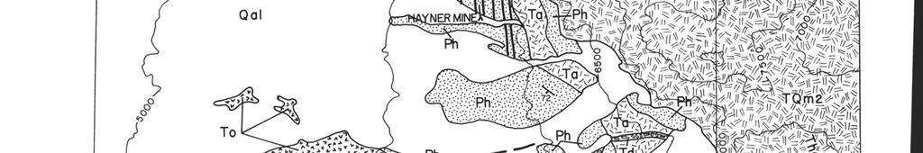
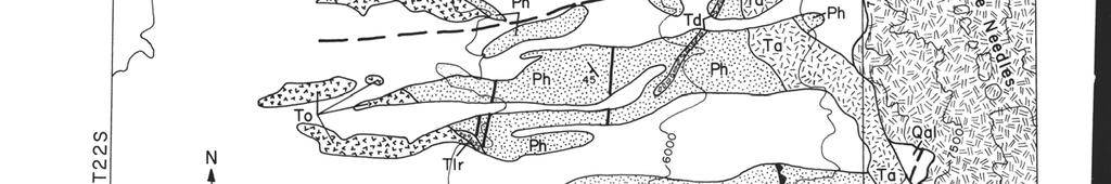
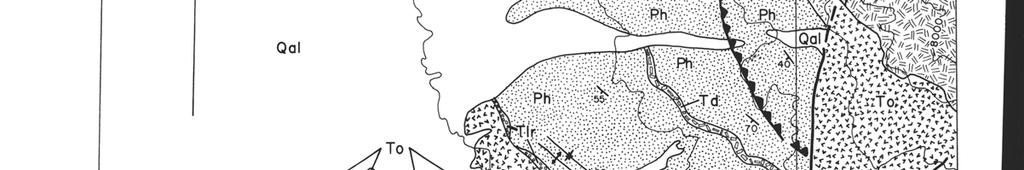
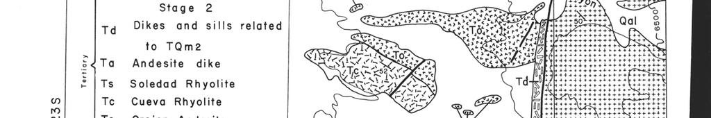
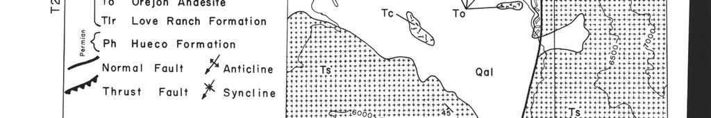
3 New Mexico Geol. Soc. Guidebook, 26th Field Conf., Las Cruces Country, GEOLOGY OF THE CENTRAL ORGAN MOUNTAINS DONA ANA COUNTY, NEW MEXICO by THOMAS G. GLOVER University of Texas at El Paso El Paso, Texas INTRODUCTION The Organ Mountains (Fig. 1) are located in mid-eastern Dona Ana County, New Mexico, 13 mi (20 km) east of Las Cruces. The mountain range encompasses about 150 sq mi and is bounded on the north by the San Andres Mountains and on the south by the Franklin Mountains. Maximum elevations in the district are above 8,900 ft, with overall relief in excess of 4,000 ft. Climate and vegetation are typical of this part of the southwestern United States, and rainfall averages about nine inches per year. K. C. Dunham (1935) established the basic geologic framework of the Organ Mountains and prepared a detailed description of past operations in the Organ Mining District. No major work has been published on the Organ Mountains since that time. This paper is a progress report; field work in the area will not be completed until late The final results will be included in a thesis to be submitted to the Department of Geological Sciences of the University of Texas at El Paso as a requirement for the Master of Science degree in geology. GENERAL GEOLOGIC SETTING The San Andres, Organ, and Franklin Mountains form a long north-trending mountain chain along the eastern edge of the Rio Grande basin. East of the Organ Mountains is the Tularosa Basin and west of the mountains are the Jornada del Muerto plains and Mesilla Valley. The northern half of the Organ Mountains is composed of gravels and alluvium of Tertiary-Quaternary age, volcanic rocks and intrusions of Tertiary age, Paleozoic sedimentary rocks, and granite of Precambrian age. Multiple quartz monzonite intrusions of the Organ Mountain batholith are the dominant rock types exposed. Rocks flanking the western slopes of the range were faulted and uplifted by the quartz monzonite intrusions. The Organ Mining District is located at the northern edge of the mountains where Stage 3 of the batholith is the dominant rock type. The Stage 3 intrusion is probably the source of Pb-Cu-Ag-Au-Zn mineralization in the mining district (Dunham, 1935). Ore deposits are localized in the Paleozoic sedimentary rocks and the Stage 3 quartz monzonite. Moveent of the ore-bearing fluids was probably controlled by fault and fracture systems in the area. Total mineral production from the Organ Mining District was in excess of $2.5 million. The southern half of the Organ Mountains may represent a partially exposed cauldron of middle Tertiary age (W. R. Seager, personal communication, 1975). Cueva Rhyolite, and Soledad Rhyolite fill the cauldron and dip toward the center of the structure. Seager suggests that Bishop Cap, Tortugas Mountain and the structurally high Paleozoic rocks in the central Organ Mountains may define the cauldron margin, and that fluorspar deposits in these areas may be related to the margin (see articles by Seager and McAnulty, this guidebook). STRATIGRAPHY Hueco Formation Dunham (1935) originally classified the sedimentary rocks that flank the western slopes of the Organ Mountains as the Magdalena Series (Pennsylvanian). Kottlowski and others (1956) and Kottlowski (1960) reclassified these rocks as the Hueco Formation (Permian). Preliminary fossil identification places the top two-thirds of this sequence in the upper Wolfcamp Series (D. V. LeMone and R. Simpson, personal communication, 1975). The oldest rocks exposed in the central Organ Mountains are of Permian age (Fig. 2, 3). Since the lower one-third of the formation lacks fossils and is baked and altered, its age is difficult to determine; possibly it is Pennsylvanian. However, similarities in lithology with other Hueco deposits in Dona Ana County suggest a probable Permian age. The lower contact of the section is with a Tertiary intrusion. The Hueco Formation consists of approximately 3,300 ft of thin interbedded limestone, silty limestone, sandstone, shale, and claystone that strike northwesterly and dip 35 degrees S to vertical. Thin-bedded limestone makes up the greater part of the sequence and seldom exceeds 10 ft in thickness. Beds vary greatly in character throughout the sequence, ranging from coarse-grained to fine-grained. Chert is abundant and occurs in nodules or beds. Fossils are absent in the lower one-third of the sequence, but are present in most other parts of the formation. The most common groups present are brachiopods, crinoids, corals, bryozoans, cephalopods, gastropods, and fusulinids. Interfingering of Abo red beds occurs in the upper part of the formation. The thickness of the Abo red beds seldom exceeds 4 ft, and they are composed of unfossiliferous red-brown claystone. Baking of some of the beds leaves the Abo as a bleached, dense, hornfelsic rock. Love Ranch Formation A conglomerate along the western front of the Organ Mountains was first described by Dunham (1935) as a basal conglomerate overlying the Paleozoic sedimentary rocks. Kottlow-

4
5 ski and others (1956) described and tentatively correlated the formation with Love Ranch Formation in the San Andres Mountains. An angular unconformity of 10 to 20 separates the Love Ranch Formation from the underlying Hueco Formation. Kottlowski and others (1956) consider the deposit to be early Tertiary in age and Seager and others (1971) believe the deposit to be formed by erosion of Laramide structures. The conglomerate occurs as thin tongues ranging in thickness from 0 to 50 ft. The conglomerate consists of about 50 percent cobbles and boulders, both angular and rounded, derived mostly from the underlying Hueco Formation. Fragments of schist, gneiss, quartzite, and granite are present in the upper part of the unit. The matrix is white to gray calcareous sandstone and siltstone. Orejon Andesite The type locality for the Orejon Andesite is at the Orejon Mine in the mouth of Fillmore Canyon (Fig. 2). The Palm Park Formation in northern Dona Ana County probably is time equivalent to the Orejon Andesite (Seager, personal communication, 1975). An andesite sequence similar to the Palm Park was dated by the K-Ar method at 43 m.y. (Kottlowski and others, 1969). Both the Love Ranch Formation and the Hueco Formation are unconformably overlain by Orejon Andesite. The Orejon sequence is composed of approximately 1,200 ft of andesite-latite boulder conglomerate and breccia, tuffaceous mudstone, and andesite-latite flows which range in thickness from a few inches up to 75 ft. The lithology of many of the deposits suggests laharic origin. The conglomerate and breccia contain boulders up to several feet in diameter and are characteristically poorly sorted. The matrix consists of grains of plagioclase, quartz, vitric ash, and rock fragments less than 1 mm in size. The thin-bedded mudstone and flows have the same basic composition as the conglomerate and breccia matrix, but are well sorted. The basal unit of the Orejon Andesite is distinctive white tuff. The formation was mapped separately by Dunham (1935), but I consider it to be part of the Orejon sequence.
6 160 GLOVER Cueva Rhyolite The type locality for the Cueva Rhyolite is at the mouth of Fillmore Canyon. A tilted sequence of rhyolite tuff striking N 58 W and dipping 55 S has been weathered out, and an Indian dwelling at the base of the monolith bears the name La Cueva. Seager (personal communication, 1975) believes the Cueva Rhyolite to be coeval with at least part of the Bell Top Formation (Oligocene) found in the Sierra de las Uvas, Dona Ana County. Radiometric K-Ar dates of 34 and 35 m.y. have been established for the tuff 5 member of the Bell Top (Clemons and Seager, 1973). The Cueva Rhyolite disconformably overlies the Orejon Andesite, and the two are distinguished on the basis of composition and color. The type section is approximately 250 ft thick. The formation is a massive white rhyolite tuff. It has a cryptocrystalline groundmass with bands of pale brown glass. Near the base of the formation, the groundmass has a purplish tint. Calcite and white mica are abundant and large boulders of rhyolite up to 2 ft in diameter occur in the upper part of the formation. Soledad Rhyolite Most of the rock exposed in the southern Organ Mountains is the Soledad Rhyolite. The formation is composed of more than 2,500 ft of rhyolite tuff and lava flows (Dunham, 1935). Part of the Bell Top Formation in the Sierra de las Uvas may be about the same age as the Soledad Rhyolite (Seager, personal communication, 1975) in spite of a K-Ar date of 25 m.y. reported for the Soledad (Seager, 1973). Radiometric K-Ar dates of 34 m.y. and 35 m.y. have been established for the tuff 5 member of the Bell Top Formation and 26 m.y. for the overlying Uvas Basaltic Andesite. The Soledad Rhyolite lies conformably on the Cueva Rhyolite. However, distinction between the two is obvious, as the Cueva Rhyolite is white and the Soledad Rhyolite usually has a purplish tint. Individual units in the sequence range from 50 ft up to possibly 500 ft. The flows and tuffs are porphyritic and range in color from gray to purple. The groundmass is coarse and has a spongy texture. Common minerals present are quartz, potash feldspar, biotite, cristobalite, and plagioclase. Compressed pumice, vitric ash, and other rock fragments are also locally abundant. INTRUSIVE IGNEOUS ROCKS Andesite Dike A large andesite dike cuts the Paleozoic sedimentary rocks and parallels the Stage 2 quartz monzonite intrusion. The dike is more than 400 ft thick in some areas and is approximately 4,000 ft long. Emplacement of the mass may be associated with the uplift of the region during early Tertiary time. The dike is a dark-colored porphyritic andesite. It is composed of 20 to 50 percent plagioclase, 5 to 20 percent hornblende and biotite, and up to 10 percent potash feldspar. Phenocrysts of plagioclase are equigranular and average 2 mm in length. The groundmass is very fine grained and cut by veinlets of pyrite and chalcopyrite. Accessory minerals are epidote, magnetite, hematite, sphene, quartz, pyrite, and chalcopyrite. Alteration is moderate to very strong. Organ Mountain Batholith The highest and most impressive group of peaks in the Organ Mountains have a multiple silicic intrusion at their core (Fig. 1). The batholith forms the Organ Needles, Rabbit Ears, Baylor Peak, and Sugarloaf Peak. It is a northwest-trending areal exposure of approximately 60 sq mi and a vertical exposure of more than 1,500 ft. Only Stage 2 of the three stage intrusion is exposed in the west central Organ Mountains. The intrusive cuts the Paleozoic sedimentary rocks, the Orejon Andesite, and the andesite dike. Many blocks of both the andesite dike and the Orejon sequence, some up to 20 ft in diameter, are found as xenoliths in the batholith. The intrusive contact is usually very distinct and easily recognized in the field. The exact age of the Stage 2 intrusive has not been determined, but the Stage 3 intrusion in the Organ Mining District has been dated radiometrically at 27 m.y. (Kottlowski and others, 1969). Microscopic examination of the Stage 2 intrusion reveals that the rock borders in composition between quartz monzonite and granite. It is buff-colored, medium-grained, equigranular, and moderately altered. The quartz monzonite contains 45 to 60 percent potash feldspar, 15 to 25 percent plagioclase, 20 to 25 percent quartz, 2 to 3 percent amphibole, and less than 1 percent biotite. Alteration products are chiefly magnetite, calcite, sericite, and kaolinite. Zoning of the plagioclase is very conspicuous and albite and Carlsbad twinning are usually well developed. Miscellaneous Dikes and Sills Two small dikes and a sill cut formations along the western front of the range. All have the same general composition and appear to be related to the Stage 2 quartz monzonite. However, none of them are found in direct contact with the batholith. Thickness of the sill is approximately 6 ft and its exposed length is in excess of 1,400 ft. It crops out northwest of the Modoc Mine in the Hueco Formation. The sill is latite porphyry, consisting of 60 percent plagioclase and 30 percent potash feldspar. Phenocrysts of plagioclase are equigranular and average 1.5 mm in length. The groundmass is fine-grained. Accessory minerals are biotite, magnetite, and zircon. The rock is moderately altered. A large dike is located in the main north-trending fault south of the Modoc Mine. It is more than 100 ft thick and has a strike length of at least 2,300 ft. The dike is in contact with the Hueco Formation, Orejon Andesite, and Soledad Rhyolite. If the dike is part of the Stage 2 quartz monzonite, a relative age between the batholith and the Soledad Rhyolite is indicated. No other contact between the Soledad Rhyolite and the batholith is seen in the Organ Mountains (Dunham, 1935). The dike is quartz latite porphyry, consisting of 40 percent plagioclase, 35 percent potash feldspar, and 18 percent quartz. Phenocrysts of plagioclase are equigranular and average 2 mm in length. The groundmass is fine grained. Accessory minerals are biotite, zircon, and magnetite. Alteration is moderate to strong. Tertiary-Quaternary Valley Fill Fan deposits and slope colluvium along the western front make up the major valley fill units. Up to several hundred feet of alluvium is present, generally thickest in alluvial fans where
7 CENTRAL ORGAN MOUNTAINS 161 pebbles and boulders are rounded and show strong weathering effects. STRUCTURE Faulting in the central Organ Mountains is of two basic types: high-angle normal faults and small thrust faults. Both types represent faulting related to emplacement of the batholith. Major trends of the high-angle normal faults are north, northeast, and east-west. A small anticline and syncline in the Hueco Formation are located west of the Modoc Mine. Formation of these structures may have occurred prior to emplacement of the batholith. MINERALIZATION Fluorspar and lead minerals are probably the only economic minerals concentrated in commercial-size deposits in the central Organ Mountains. Minor amounts of chalcopyrite and silver occur in the area. The age of mineralization for the fluorspar and lead deposits is probably mid-tertiary. Most of the known fluorspar in the area is on the Hayner claims, where it occurs in at least eleven nearly parallel vein and fracture zones striking N 20 E and dipping 55 to 70 E. The No. 1 Vein is a bedding plane vein which dips 45 to 60 W. The veins are in a belt of fractured, mildly distorted, and partly metamorphosed limestone and shale of the Hueco Formation. Fluorspar also occurs in veins in the andesite dike. East of the andesite dike is a section of limestone in contact with the quartz monzonite in which several narrow veins of fluorspar occur. Fluorspar is found along both the east and west contact of the andesite dike all the way from the Hayner Mine to the Modoc Mine. Ore ranges from coarse to fine grained and ranges in color from white to deep wine to apple green. Gangue minerals include barite, calcite, and quartz. Quartz was the first mineral deposited, followed by alternate depositions of calcite and fluorite. Only 400 tons of fluorspar have been produced to this date. The lead minerals, principally galena, occur as small replacement bodies in the Hueco Formation at the Modoc Mine. Mining between 1879 and 1905 produced ore valued at about $200,000 (Dunham, 1935). The Modoc deposit was classified as pyrometasomatic by Dunham (1935). It is adjacent to the large north-trending fault in the area. Galena is the only ore mineral, and it is essentially non-argentiferous. Gangue minerals include chlorite, andradite, specular hematite, epidote, and quartz. ACKNOWLEDGMENTS I wish to thank the New Mexico Bureau of Mines for financial support of my thesis. Advice and assistance in the field by Dr. W. N. McAnulty, University of Texas at El Paso, is appreciated. I also wish to thank W. Tipton of the Bureau of Land Management and Dr. W. R. Seager, New Mexico State University, for their help. REFERENCES Clemons, R. E. and Seager, W. R., 1973, Geology of the Souse Springs quadrangle, Dona Ana County, New Mexico: New Mex. Bur. Mines and Min. Res. Bull. 100, 31 p. Dunham, K. C., 1935, The geology of the Organ Mountains: New Mex. Bur. Mines and Min. Res. Bull. 11, 272 p. Kottlowski, F. E., Flower, R. H., Thompson, M. L., and Foster, R. W., 1956, Stratigraphic studies of the San Andres Mountains, New Mexico: New Mex. Bur. Mines and Min. Res. Mem. 1, 132 p. Kottlowski, F. E., 1960, Reconnaissance geologic map of Las Cruces thirty-minute quadrangle: New Mex. Bur. Mines and Min. Res. Geol. Map 14. Kottlowski, F. E., Weber, R. H., and Willard, M. E., 1969, Tertiary intrusive-volcanic mineralization episodes in the New Mexico region: Geol. Soc. America, Abs. with Programs for 1969, pt. 7, p Seager, W. R., 1973, Geologic map and sections of Bishop Cap-Organ Mountains area, New Mexico: New Mex. Bur. Mines and Min. Res. Geol. Map 29. Seager, W. R., Hawley, J. W., and Clemons, R. E., 1971, Geology of the San Diego Mountain area, Dona Ana County, New Mexico: New Mex. Bur. Mines and Min. Res. Bull. 97, 36 p.
New Mexico Geological Society
 New Mexico Geological Society Downloaded from: http://nmgs.nmt.edu/publications/guidebooks/26 Tectonic significance of the Pony Hills, Luna County, New Mexico LeRoy L. Corbitt and Fred L. Nials, 1975,
Geologic Map of the Hatch Quadrangle, Doña County, New Mexico
 Geologic Map of the Hatch Quadrangle, Doña County, New Mexico By William R. Seager May 1995 New Mexico Bureau of Geology and Mineral Resources Open-file Digital Geologic Map OF-GM 213 Scale 1:24,000 This
New Mexico Geological Society
 New Mexico Geological Society Downloaded from: http://nmgs.nmt.edu/publications/guidebooks/43 Volcanic geology of the Rio Puerco necks R. Bruce Hallett, 1992, pp. 135-144 in: San Juan Basin IV, Lucas,
New Mexico Geological Society
 New Mexico Geological Society Downloaded from: http://nmgs.nmt.edu/publications/guidebooks/26 Direct-current soundings on the La Mesa surface near Kilbourne and Hunts Holes, New Mexico Dallas B. Jackson
New Mexico Geological Society
 New Mexico Geological Society Downloaded from: http://nmgs.nmt.edu/publications/guidebooks/25 Outline of the igneous geology of the Jemez Mountain volcanic field A. M. Kudo, 1974, pp. 287-289 in: Ghost
New Mexico Geological Society
 New Mexico Geological Society Downloaded from: http://nmgs.nmt.edu/publications/guidebooks/29 Laramide thrust faulting, Klondike Hills, southwestern New Mexico LeRoy L. Corbitt, F. L. Nials, and R. J.
New Mexico Geological Society
 New Mexico Geological Society Downloaded from: http://nmgs.nmt.edu/publications/guidebooks/25 Structure of the Guadalupe Box area, Sandoval County, New Mexico Harvey R. DuChene, 1974, pp. 131-135 in: Ghost
Practice Test Rocks and Minerals. Name. Page 1
 Name Practice Test Rocks and Minerals 1. Which rock would be the best source of the mineral garnet? A) basalt B) limestone C) schist D) slate 2. Which mineral is mined for its iron content? A) hematite
New Mexico Geological Society
 New Mexico Geological Society Downloaded from: http://nmgs.nmt.edu/publications/guidebooks/19 Vanadium deposits of the Placerville area, San Miguel County, Colorado R. P. Fischer, 1968, pp. 100-103 in:
Review - Unit 2 - Rocks and Minerals
 Review - Unit 2 - Rocks and Minerals Base your answers to questions 1 and 2 on the diagram below, which shows the results of three different physical tests, A, B, and C, that were performed on a mineral.
RR#7 - Multiple Choice
 1. Which mineral is mined for its iron content? 1) hematite 2) fluorite 3) galena 4) talc 2. Which rock is composed of the mineral halite that formed when seawater evaporated? 1) limestone 2) dolostone
COMPOSITIONAL TERMS: FELSIC : light colored INTERMEDIATE : medium shades MAFIC : dark colored ULTRAMAFIC : rare (composition of the mantle)
") GEOLOGY 306 Laboratory NAME: Instructor: TERRY J. BOROUGHS SECTION: Common Rocks (Chapter 2) For this assignment, you will require: a streak plate, glass plate, magnet, dilute hydrochloric (HCl) acid,
GEOLOGY 306 Laboratory NAME: Instructor: TERRY J. BOROUGHS SECTION: Common Rocks (Chapter 2) For this assignment, you will require: a streak plate, glass plate, magnet, dilute hydrochloric (HCl) acid,
Rock Identification. invisible rhyolite andesite basalt komatiite. visible granite diorite gabbro peridotite
 Rock Identification The samples in this lab are arranged into four groups: igneous, sedimentary, metamorphic, and unknown. Study the igneous, sedimentary, and metamorphic collections to get an idea of
New Mexico Geological Society
 New Mexico Geological Society Downloaded from: http://nmgs.nmt.edu/publications/guidebooks/13 Paleontological reconnaissance of subsurface Pennsylvanian in southern pache and Navajo Counties, rizona Donald
New Mexico Geological Society
 New Mexico Geological Society Downloaded from: http://nmgs.nmt.edu/publications/guidebooks/15 Resume of the geology of the Gallinas Mountains, New Mexico Ralph M. Perhac, 1964, pp. 87-91 in: Ruidoso Country
Unit 2: Minerals and Rocks Practice Questions
 Name: Date: 1. Which mineral is white or colorless, has a hardness of 2.5, and splits with cubic cleavage? 6. Base your answer(s) to the following question(s) on the photograph of a sample of gneiss below.
LAB 2 IDENTIFYING MATERIALS FOR MAKING SOILS: ROCK AND PARENT MATERIALS
 LAB 2 IDENTIFYING MATERIALS FOR MAKING SOILS: ROCK AND PARENT MATERIALS Learning outcomes The student is able to: 1. understand and identify rocks 2. understand and identify parent materials 3. recognize
=%REPORT RECONNAISSANCE OF CHISHOLM LAKE PROSPECT. October 25, 1977
 =%REPORT ON FIELD RECONNAISSANCE OF CHISHOLM LAKE PROSPECT October 25, 1977 Bruce D. Vincent Imperial Oil Limited, Minerals - Coal, CALGARY, ALBERTA CHISHOLM LAKE PROSPECT Introduction The Chisholm Lake
NAME HOMEWORK ASSIGNMENT #3 MATERIAL COVERS CHAPTERS 8, 9, 10, 11
 NAME HOMEWORK ASSIGNMENT #3 MATERIAL OVERS HAPTERS 8, 9, 10, 11 Assignment is due the beginning of the class period on November 23, 2004. Answers for each chapter will be discussed in class, as Exam #3
Which rock is shown? A) slate B) dunite C) gneiss D) quartzite
 slate B) dunite C) gneiss D) quartzite") 1. Which metamorphic rock will have visible mica crystals and a foliated texture? A) marble B) quartzite C) schist D) slate 2. The recrystallization of unmelted material under high temperature and pressure
1. Which metamorphic rock will have visible mica crystals and a foliated texture? A) marble B) quartzite C) schist D) slate 2. The recrystallization of unmelted material under high temperature and pressure
Applications and Investigations in Earth Science Seventh Edition
 INSTRUCTOR MANUAL Stanley C. Hatfield Southwestern Illinois College Applications and Investigations in Earth Science Seventh Edition Tarbuck Lutgens Pinzke Exercise One The Study of Minerals MATERIALS
New Mexico Geological Society
 New Mexico Geological Society Downloaded from: http://nmgs.nmt.edu/publications/guidebooks/16 The Cameron Creek laccolith: a trap-door intrustion near Silver City, New Mexico Walden P. Pratt and William
ENGLE COAL FIELD. David E. Tabet
 OPEN FILE REPORT 115 SUMMARY OF THE GEOLOGY OF THE ENGLE COAL FIELD by David E. Tabet THE ENGLE COAL FIELD Introduction The Engle coal field (Lee, 1905), named for the small town of Engle along the Santa
1. Base your answer to the following question on on the photographs and news article below. Old Man s Loss Felt in New Hampshire
 UNIT 3 EXAM ROCKS AND MINERALS NAME: BLOCK: DATE: 1. Base your answer to the following question on on the photographs and news article below. Old Man s Loss Felt in New Hampshire FRANCONIA, N.H. Crowds
ARGENTINE FRONTIER RESOURCES INC (AFRI) SALTA EXPLORACIONES SA (SESA)
 SALTA EXPLORACIONES SA (SESA)") ARGENTINE FRONTIER RESOURCES INC (AFRI) SALTA EXPLORACIONES SA (SESA) LA SARITA IOCG-Porphyry Copper-Gold August 2006 La Sarita Cateo 2 La Sarita - bleached center is Taca Taca Arriba. The hematite zone
ARGENTINE FRONTIER RESOURCES INC (AFRI) SALTA EXPLORACIONES SA (SESA) LA SARITA IOCG-Porphyry Copper-Gold August 2006 La Sarita Cateo 2 La Sarita - bleached center is Taca Taca Arriba. The hematite zone
New Mexico Geological Society
 New Mexico Geological Society Downloaded from: http://nmgs.nmt.edu/publications/guidebooks/35 Structural anomalies in the Espanola Basin Bruce A. Black, 1984, pp. 59-62 in: Rio Grande Rift (Northern New
2. What is sample 1B? a. chalcopyrite b. plagioclase feldspar c. muscovite d. copper e. magnetite f. galena g. pyrite
 HSAG Mineral and Rock Exam 2014 Note: Most sample numbers do NOT match question numbers so be careful. Team: 1. What is sample 1A? a. magnetite b. galena c. pyrite d. chalcopyrite e. copper f. graphite
Unit 2 Exam: Rocks & Minerals
 Name: Date: 1. Base your answer(s) to the following question(s) on the 2001 edition of the Earth Science Reference Tables, the map and cross section below, and your knowledge of Earth science. The shaded
This file was created by scanning the printed publication. Errors identified by the software have been corrected; however, some errors may remain.
 This file was created by scanning the printed publication. Errors identified by the software have been corrected; however, some errors may remain. GEOLOGY OF TENDERFOOT CREEK EXPERIMENTAL FOREST LITTLE
Structural Geology Lab. The Objectives are to gain experience
 Geology 2 Structural Geology Lab The Objectives are to gain experience 1. Drawing cross sections from information given on geologic maps. 2. Recognizing folds and naming their parts on stereoscopic air
B) color B) Sediment must be compacted and cemented before it can change to sedimentary rock. D) igneous, metamorphic, and sedimentary rocks
 color B) Sediment must be compacted and cemented before it can change to sedimentary rock. D) igneous, metamorphic, and sedimentary rocks") 1. Which characteristic of nonsedimentary rocks would provide the least evidence about the environment in which the rocks were formed? A) structure B) color C) crystal size D) mineral composition 2. Which
1. Which characteristic of nonsedimentary rocks would provide the least evidence about the environment in which the rocks were formed? A) structure B) color C) crystal size D) mineral composition 2. Which
As compaction and cementation of these sediments eventually occur, which area will become siltstone? A) A B) B C) C D) D
 A B) B C) C D) D") 1. A student obtains a cup of quartz sand from a beach. A saltwater solution is poured into the sand and allowed to evaporate. The mineral residue from the saltwater solution cements the sand grains together,
1. A student obtains a cup of quartz sand from a beach. A saltwater solution is poured into the sand and allowed to evaporate. The mineral residue from the saltwater solution cements the sand grains together,
Chapter 10. Chapter Rocks and the Rock Cycle. Rocks. Section 1 Rocks and the Rock Cycle
 Chapter 10 Rocks 1 Chapter 10 Section 1 Rocks and the Rock Cycle 2 10.1 Rocks and the Rock Cycle Magma is the parent material for all rocks. Once the magma cools and hardens, many changes can occur. Geology:
Geology 252, Historical Geology, California State University, Los Angeles - professor: Dr. Alessandro Grippo
 LAB # 1 - CLASTIC ROCKS Background: - Mechanical and Chemical Weathering - Production of Clastic Sediment - Classification of Sediment according to size: Gravel, Sand, Silt, Clay - Erosion, Transportation
New Mexico Geological Society
 New Mexico Geological Society Downloaded from: http://nmgs.nmt.edu/publications/guidebooks/27 Structural framework of the southern Raton Basin, New Mexico Lee A. Woodward and D. O. Snyder, 1976, pp. 125-127
Page 1. Name: 1) Which diagram best shows the grain size of some common sedimentary rocks?
 Which diagram best shows the grain size of some common sedimentary rocks?") Name: 1) Which diagram best shows the grain size of some common sedimentary rocks? 1663-1 - Page 1 5) The flowchart below illustrates the change from melted rock to basalt. 2) Which processes most likely
Name: 1) Which diagram best shows the grain size of some common sedimentary rocks? 1663-1 - Page 1 5) The flowchart below illustrates the change from melted rock to basalt. 2) Which processes most likely
General Geology Lab #7: Geologic Time & Relative Dating
 General Geology 89.101 Name: General Geology Lab #7: Geologic Time & Relative Dating Purpose: To use relative dating techniques to interpret geological cross sections. Procedure: Today we will be interpreting
Which sample best shows the physical properties normally associated with regional metamorphism? (1) A (3) C (2) B (4) D
 A (3) C (2) B (4) D") 1 Compared to felsic igneous rocks, mafic igneous rocks contain greater amounts of (1) white quartz (3) pink feldspar (2) aluminum (4) iron 2 The diagram below shows how a sample of the mineral mica breaks
1 Compared to felsic igneous rocks, mafic igneous rocks contain greater amounts of (1) white quartz (3) pink feldspar (2) aluminum (4) iron 2 The diagram below shows how a sample of the mineral mica breaks
GEOLOGY OF THE NICOLA GROUP BETWEEN MISSEZULA LAKE AND ALLISON LAKE
 GEOLOGY OF THE NICOLA GROUP BETWEEN MISSEZULA LAKE AND ALLISON LAKE (92H/15E. 10E1 By V. A. Preto INTRODUCTION Mapping was continued southward from the area covered in 1973 and an additional 55 square
Name Regents Review #7 Date
 Name Regents Review #7 Date Base your answers to questions 1 and 2 on the pictures of four rocks shown below. Magnified views of the rocks are shown in the circles. 5. The diagrams below show the crystal
Version 1 Page 1 Barnard/George/Ward
 The Great Mineral & Rock Test 1. Base your answer to the following question on the table below which provides information about the crystal sizes and the mineral compositions of four igneous rocks, A,
Quiz 1. 3) Which of the following planetary bodies has the least number of impact craters on its surface? A) Mercury B) Mars C) the Moon D) Earth
 Which of the following planetary bodies has the least number of impact craters on its surface? A) Mercury B) Mars C) the Moon D) Earth") Quiz 1 1) Earth's atmosphere is unique among the moons and planets in that A) it has a nitrogen (N2) rich atmosphere. B) it is rich in oxygen (O2) and nitrogen (N2). C) it is rich in carbon dioxide because
Quiz 1 1) Earth's atmosphere is unique among the moons and planets in that A) it has a nitrogen (N2) rich atmosphere. B) it is rich in oxygen (O2) and nitrogen (N2). C) it is rich in carbon dioxide because
GEOLOGY AND COPPER DEPOSITS OF THE TYRONE DISTRICT
 GEOLOGY AND COPPER DEPOSITS OF THE TYRONE DISTRICT 127 By JOSEPH KOLESSAR Phelps Dodge Corporation GEOLOGIC SETTING The Tyrone copper deposit is located in the Burro Mountains mining district in Grant
Rocks. Rocks are composed of 1 or more minerals. Rocks are classified based on how they formed (origin). 3 classes of rocks:
. 3 classes of rocks:") ROCKS Rocks If a mineral is a naturally occurring homogeneous solid, inorganically formed, with a definite chemical composi:on and a crystalline structure then what is a rock? Rocks Rocks are composed
ROCKS Rocks If a mineral is a naturally occurring homogeneous solid, inorganically formed, with a definite chemical composi:on and a crystalline structure then what is a rock? Rocks Rocks are composed
Answers. Rocks. Year 8 Science Chapter 8
 Answers Rocks Year 8 Science Chapter 8 p171 1 Rocks are made up of minerals such as quartz, feldspars, micas, and calcite. Different rocks are made up of different combinations of minerals. 2 Igneous,
Block: Igneous Rocks. From this list, select the terms which answer the following questions.
 Geology 12 Name: Mix and Match: Igneous Rocks Refer to the following list. Block: porphyritic volatiles mafic glassy magma mixing concordant discontinuous reaction series igneous vesicular partial melting
New Mexico Geological Society
 New Mexico Geological Society Downloaded from: http://nmgs.nmt.edu/publications/guidebooks/34 Recent measurements of crustal deformation related to the Socorro magma body, New Mexico Shawn Larsen and Robert
Rocks and the Rock Cycle notes from the textbook, integrated with original contributions
 Rocks and the Rock Cycle notes from the textbook, integrated with original contributions Alessandro Grippo, Ph.D. Gneiss (a metamorphic rock) from Catalina Island, California Alessandro Grippo review Rocks
New Mexico Geological Society
 New Mexico Geological Society Downloaded from: http://nmgs.nmt.edu/publications/guidebooks/9 Summary of coal resources of the Black Mesa coal field, Arizona R. B. O'Sullivan, 1958, pp. 169-171 in: Black
A. IGNEOUS Rocks formed by cooling and hardening of hot molten rock called magma (within crust or at its surface).
.") EARTH SCIENCE 11 CHAPTER 5 NOTES KEY How Earth's Rocks Were Formed Early geologists believed that the physical features of the Earth were formed by sudden spectacular events called CATASTROPHES. Modern
EARTH SCIENCE 11 CHAPTER 5 NOTES KEY How Earth's Rocks Were Formed Early geologists believed that the physical features of the Earth were formed by sudden spectacular events called CATASTROPHES. Modern
New Mexico Geological Society
 New Mexico Geological Society Downloaded from: http://nmgs.nmt.edu/publications/guidebooks/10 Geological summary of the Magdalena mining district, Socorro County, New Mexico Spencer R. Titley, 1959, pp.
The 3 types of rocks:
 Igneous Rocks and Intrusive Igneous Activity The 3 types of rocks:! Sedimentary! Igneous! Metamorphic Marble 1 10/7/15 SEDIMENTARY ROCKS Come from rocks sediments (rock fragments, sand, silt, etc.) Fossils
GEOL FORENSIC GEOLOGY ROCK IDENTIFICATION
 GEOL.2150 - FORENSIC GEOLOGY ROCK IDENTIFICATION Name I. Introduction There are three basic types of rocks - igneous, sedimentary, and metamorphic: Igneous. Igneous rocks have solidified from molten matter
40-50 Minutes, 3 minutes per station, 13 Stations, samples provided by UWM and Pierre Couture
 Event: Judge: Rocks & Minerals Pierre couture 40-50 Minutes, 3 minutes per station, 13 Stations, samples provided by UWM and Pierre Couture 1-4 Minerals (50 points total) 5-7 Igneous Rocks (50 points total)
New Mexico Geological Society
 New Mexico Geological Society Downloaded from: http://nmgs.nmt.edu/publications/guidebooks/21 Thrust faults of Florida Mountains, New Mexico, and their regional tectonic significance LeRoy L. Corbitt and
Drill locations for the 2015 program are highlighted in the geology map below.
 2015 Exploration Program The exploration program plan at KSM for 2015 was designed to improve the understanding of block cave targets and support engineering/environmental aspects of development scenarios.
Name Class Date. Chapter 3 Rocks Chapter Test. Write the letter that best answers the question or completes the statement on the line provided.
 Chapter 3 Rocks Chapter Test Multiple Choice Write the letter that best answers the question or completes the statement on the line provided. 1. Which of the following is true about rocks? a. Rocks are
Geology of San Diego Mountain Area Doña Ana County, New Mexico
 BULLETIN 97 Geology of San Diego Mountain Area Doña Ana County, New Mexico by WILLIAM R. SEAGER JOHN W. HA WLEY RUSSELL E. CLEMONS 1971 New Mexico State Bureau of Mines and Mineral Resources New Mexico
1. Base your answer to the following question on The diagram below represents a part of the crystal structure of the mineral kaolinite.
 1. Base your answer to the following question on The diagram below represents a part of the crystal structure of the mineral kaolinite. An arrangement of atoms such as the one shown in the diagram determines
The Cobalt Rainbow. Airborne geophysical maps show that a north trending aeromagnetic high suggests further undiscovered mineralisation.
 The Cobalt Rainbow The property is located on Greenstone Creek, approximately 4.8 kilometres south west of the creek mouth. The property is located about 24 km due west of Campbell River, in the east-central
OPOSURA PROJECT, MOCTEZUMA, SONORA, MÉXICO, A HIGH GRADE ZN-PB, AG (CU, MO), ADVANCED STAGE, SKARN DEPOSIT (34) Expositor Día Hora Sala
, ADVANCED STAGE, SKARN DEPOSIT (34) Expositor Día Hora Sala") OPOSURA PROJECT, MOCTEZUMA, SONORA, MÉXICO, A HIGH GRADE ZN-PB, AG (CU, MO), ADVANCED STAGE, SKARN DEPOSIT (34) Expositor Día Hora Sala Cruz Paez Viernes 26 12:30 13:00 Sala A Cruz Enrique Paez Minera
OPOSURA PROJECT, MOCTEZUMA, SONORA, MÉXICO, A HIGH GRADE ZN-PB, AG (CU, MO), ADVANCED STAGE, SKARN DEPOSIT (34) Expositor Día Hora Sala Cruz Paez Viernes 26 12:30 13:00 Sala A Cruz Enrique Paez Minera
Wednesday 22 May 2013 Morning
 Wednesday 22 May 2013 Morning AS GCE GEOLOGY F792/01 Rocks Processes and Products *F713000613* Candidates answer on the Question Paper. OCR supplied materials: None Other materials required: Ruler (cm/mm)
Rocks Rock- A group of minerals, glass, mineroid bound together in some way.
 Rocks Rock- A group of minerals, glass, mineroid bound together in some way. All rocks fit into one of three categories: Igneous- formed by the cooling and hardening of hot molten rock Sedimentary- formed
Page 1. Name:
 Name: 1) What is the approximate density of a mineral with a mass of 262.2 grams that displaces 46 cubic centimeters of water? A) 6.1 g/cm 3 C) 1.8 g/cm 3 B) 5.7 g/cm 3 D) 12.2 g/cm 3 2) In which two Earth
Topics that will be discussed
 Topics that will be discussed The Rock Cycle Igneous Rock Sedimentary Rock Metamorphic Rock The Rock Cycle -Rocks The parent material for all rocks is MAGMA. What is MAGMA? -Rock forming Minerals Are:
Essentials of Geology, 11e
 Essentials of Geology, 11e Igneous Rocks and Intrusive Activity Chapter 3 Instructor Jennifer Barson Spokane Falls Community College Geology 101 Stanley Hatfield Southwestern Illinois College Characteristics
*Theory= If all available testing support a hypothesis. *Law= Theory that continually passes all tests over long periods of time.
 Rodrigo Rivera-Reyes GEOL 1104/1114 Updated October 2012 GEOL LAB Midterm 1 Study Guide 1. Scientific Method. O Observation.- Something is noticed and causes a question to be asked. H Hypothesis.- Proposed
Igneous Rocks. Sedimentary Rocks. Metamorphic Rocks
 Name: Date: Igneous Rocks Igneous rocks form from the solidification of magma either below (intrusive igneous rocks) or above (extrusive igneous rocks) the Earth s surface. For example, the igneous rock
Sedimentary Rocks. Origin, Properties and Identification. Geology Laboratory GEOL 101 Lab Ray Rector - Instructor
 Sedimentary Rocks Origin, Properties and Identification Geology Laboratory GEOL 101 Lab Ray Rector - Instructor Sedimentary Rock Origin and Identification Lab Pre-Lab Internet Link Resources 1) http://www.rockhounds.com/rockshop/rockkey/index.html
transform boundary Photograph by Robert E. Wallace, USGS.
 transform boundary The San Andreas Fault is undoubtedly the most famous transform boundary in the world. To the west of the fault is the Pacific plate, which is moving northwest. To the east is the North
New Mexico Geological Society
 New Mexico Geological Society Downloaded from: http://nmgs.nmt.edu/publications/guidebooks/21 Mineralization and alteration in calcareous rocks near the Santa Rita stock, New Mexico Richard L. Nielson,
New Mexico Geological Society
 New Mexico Geological Society Downloaded from: http://nmgs.nmt.edu/publications/guidebooks/21 Contact metamorphism in the Tres Hermanas, Luna County, New Mexico Frank C. Homme and Abraham Rosenzweig, 1970,
Page 1. Name:
 Name: Questions 1 through 3 refer to the following: The diagrams below represent two rock outcrops found several miles apart in New York State. Individual rock layers are lettered, and fossils and rock
Comprehensive Final Exam EXAM RETURN EXAM RETURN EXAM RETURN
 Exams will be returned 15 minutes before end. RESULTS: A: B: C: D: F: % of class got As and Bs CONGRATS! % got a D or less If your grade is what you want, keep up the good work! If not, see me for advice.
1. Which mineral is mined for its iron content? A) hematite B) fluorite C) galena D) talc
 hematite B) fluorite C) galena D) talc") 1. Which mineral is mined for its iron content? A) hematite B) fluorite C) galena D) talc 2. Which material is made mostly of the mineral quartz? A) sulfuric acid B) pencil lead C) plaster of paris D)
1. Which mineral is mined for its iron content? A) hematite B) fluorite C) galena D) talc 2. Which material is made mostly of the mineral quartz? A) sulfuric acid B) pencil lead C) plaster of paris D)
 16 Figure J. A fresh sample of Monzonite Porphyry is depicted including biotite hornblende and plagioclase phenocrysts, biotite is altering to chlorite and plagioclase is altering to clay. (magnification
New Mexico Geological Society
 New Mexico Geological Society Downloaded from: http://nmgs.nmt.edu/publications/guidebooks/30 Geochronologic and rare-earth study of the Embudo granite and related rocks Marcia E. Register and D. G. Brookins,
SOUTH CERRO AZUL STRATIGRAPHIC SECTION. Upper Cerro Azul flow of the Servilleta Basalt (Tsbcau) Lower Sandlin unit (Tsl)
 Lower Sandlin unit (Tsl)") Figure A3-01 cobbles claysilt general grain size sand pebbles vf f m c vc SOUTH CERRO AZUL STRATIGRAPHIC SECTION Top at 18 m. Upper Cerro Azul flow of the Servilleta Basalt (Tsbcau) 15 Basalt: Very dark
Figure A3-01 cobbles claysilt general grain size sand pebbles vf f m c vc SOUTH CERRO AZUL STRATIGRAPHIC SECTION Top at 18 m. Upper Cerro Azul flow of the Servilleta Basalt (Tsbcau) 15 Basalt: Very dark
Geology of Quesnel and Stikine terranes and associated porphyry deposits. Jim Logan Paul Schiarizza
 Geology of Quesnel and Stikine terranes and associated porphyry deposits Jim Logan Paul Schiarizza Quesnel and Stikine terranes Major cordilleran terranes characterized by similar Late Triassic Early Jurassic
NOA ASSESSMENT HARRIS QUARRY MENDOCINO COUNTY, CALIFORNIA TABLE OF CONTENTS
 NOA ASSESSMENT HARRIS QUARRY MENDOCINO COUNTY, CALIFORNIA TABLE OF CONTENTS Introduction... 1 Scope of Services... 1 Project Location and Description... 1 Geologic Setting... 1 Regional Geology... 1 Site
Sediment and sedimentary rocks Sediment
 Sediment and sedimentary rocks Sediment From sediments to sedimentary rocks (transportation, deposition, preservation and lithification) Types of sedimentary rocks (clastic, chemical and organic) Sedimentary
Geological History of the Grand Canyon
 Geological History of the Grand Canyon For a copy of this assignment, print a copy of this web page. The Project Your job is to write a short paper that describes the geological history of the Grand Canyon
CHAPTER 3.3: METAMORPHIC ROCKS
 CHAPTER 3.3: METAMORPHIC ROCKS Introduction Metamorphism - the process of changes in texture and mineralogy of pre-existing rock due to changes in temperature and/or pressure. Metamorphic means change
Tucson Geologic History: Cenozoic ( Ma (million years ago)) Dr. Jan C. Rasmussen
) Dr. Jan C. Rasmussen") Tucson Geologic History: Cenozoic (65.5 0 Ma (million years ago)) Dr. Jan C. Rasmussen www.janrasmussen.com Temp. & Geologic Time Scale 4.6 Ga Tertiary 65-0 Ma Orogenies (mountain building) Cenozoic Formations
Tucson Geologic History: Cenozoic (65.5 0 Ma (million years ago)) Dr. Jan C. Rasmussen www.janrasmussen.com Temp. & Geologic Time Scale 4.6 Ga Tertiary 65-0 Ma Orogenies (mountain building) Cenozoic Formations
Pacific Northwest Rock Lab, Part II. Igneous Rocks. Name Per.
 Name Per. Pacific Northwest Rock Lab, Part II After you ve classified all your rocks, place their numbers next to the names and read the information about the rock. Check the classifications here (igneous,
Aliabad-Morvarid iron-apatite deposit, a Kiruna type example in Iran
 Aliabad-Morvarid iron-apatite deposit, a Kiruna type example in Iran Maryam-Sadat Mazhari 1 *, Majid Ghaderi 1, Mohammad-Hassan Karimpour 2 1 Department of Geology, Tarbiat Modares University, Tehran,
New Mexico Geological Society
 New Mexico Geological Society Downloaded from: http://nmgs.nmt.edu/publications/guidebooks/32 Rio Blanco Oil Shale Company Tract C-a, Rio Blanco County, Colorado: Summary of geology and current development
NEW HAZELTON, OMINECA M.D.,
 PROSPECTING REPORT JUDI 1 TO 6 MINERAL CLAIMS NEW HAZELTON, OMINECA M.D., B.C. MAP 93M/4E, LAT. SS014'N, LONG. 127'33'W OWNED BY: A. L'ORSA ANTHONY L'ORSA Smithers, B.C. 21 February, 1981 TABLE OF CONTENTS
Name Class Date. In your textbook, read about the nature of igneous rocks. Use each of the terms below just once to complete the following statements.
 CHAPTER 5 Igneous Rocks SECTION 5.1 What are igneous rocks? In your textbook, read about the nature of igneous rocks. Use each of the terms below just once to complete the following statements. basaltic
Rocks and Minerals (rocksandminerals)
") Name: Date: 1. Cleavage of a mineral is related to a mineral's A. chemical composition. B. streak color. C. luster. D. crystalline structure. 2. Which is not part of the definition of a mineral? A. naturally
Name: Date: 1. Cleavage of a mineral is related to a mineral's A. chemical composition. B. streak color. C. luster. D. crystalline structure. 2. Which is not part of the definition of a mineral? A. naturally
New Mexico Geological Society
 New Mexico Geological Society Downloaded from: http://nmgs.nmt.edu/publications/guidebooks/6 Mesozoic stratigraphy of south-central New Mexico Hugh P. Bushnell, 1955, pp. 81-87 in: South-Central New Mexico,
REMINDER. MOVIE: Rocks that Originate Underground 5:41 to 12:40
 REMINDER 2 chapters covered next week Sedimentary Rocks Soils and Weathering (first half) Learn vocabulary for both! Turn to Neighbor: Without using your book or notes, try to remember which te mineral
Engineering Geology ECIV 2204
 Engineering Geology ECIV 2204 Instructor : Dr. Jehad Hamad 2017-2016 Chapter (3) Igneous Rocks Chapter 3: Rocks: Materials of the Solid Earth Igneous Rocks Chapter 3: Rocks: Materials of the Solid Earth
Foundation Unit A.M. THURSDAY, 20 May hour
 Candidate Name Centre Number 2 Candidate Number GCE AS/A level 1211/01 GEOLOGY - GL1 Foundation Unit A.M. THURSDAY, 20 May 2010 1 hour Question 1 Question 2. 1211 01 01 Question 3 Question 4 Total 60 ADDITIONAL
Sedimentary Rocks. Origin, Properties and Identification. Physical Geology GEOL 101 Lab Ray Rector - Instructor
 Sedimentary Rocks Origin, Properties and Identification Physical Geology GEOL 101 Lab Ray Rector - Instructor Sedimentary Rock Origin and Identification Lab Pre-Lab Internet Link Resources 1) http://www.rockhounds.com/rockshop/rockkey/index.html
ALLEGHENY COLLEGE DEPARTMENT OF GEOLOGY STUDENT HANDBOOK
 ALLEGHENY COLLEGE DEPARTMENT OF GEOLOGY STUDENT HANDBOOK This handbook is designed as a resource for all geology majors and minors. The material contained in the handbook includes foundation principles
Earth Science Chapter 6 Rocks
 Earth Science Chapter 6 Rocks I. Rocks and the Rock Cycle * Material that makes up the solid part of the Earth. * Made of a variety of different combinations of minerals and organic matter. A. Three Major
Earth Science - Lab #11 Geologic Time
 Earth Science - Lab #11 Geologic Time Page # Below are standard geologic symbols for the 3 main categories of rocks. Although these symbols are not universal, they are generally accepted by most geologists
New Mexico Geological Society
 New Mexico Geological Society Downloaded from: http://nmgs.nmt.edu/publications/guidebooks/19 Multiple intrusions in the San Miguel Mountains, Colorado Calvin S. Bromfield and Alfred L. Bush, 1968, pp.
From Atoms to Minerals to Rocks: The building blocks of the Earth
 From Atoms to Minerals to Rocks: The building blocks of the Earth 1 Questions your students might ask? What are rocks made of? What are minerals? What are minerals? What is the difference between Fool