Technical Report. Geochemical Sampling of Raymond Creek on Vancouver Island. Victoria Mining District 092C 15. UTM Co-ordinates N E
|
|
|
- Jonathan Wheeler
- 5 years ago
- Views:
Transcription
1 Technical Report Geochemical Sampling of Raymond Creek on Vancouver Island Victoria Mining District 092C 15 UTM Co-ordinates N E Owner of Claims is Dean Arbic(133434) Report Written by Dean Arbic Work Performed and Supervised by Dean Arbic Event Numbers Report Date January
2 Table of Contents Title Page...1 Table of Contents...2 Confirmation Pages Introduction and Claim History...7 Regional Geology...8 Technical Work Description...9, 10 Equipment and Tools Used...11 Statement of Work and Cost...12 Conclusions and Interpretations...13 Hardware Software and Qualifications and Sources...13 Road and Trail Access Location Map...14 Sample Location Map...15 Sample Location Sketches...16,17,18 Photographs of Sample Locations
3 Introduction, Claim Location and History This report documents the work performed on the mineral claims named; Zodiac (603588), Libra (733862), Constitution (904529) and Marigold (904489). These claims are located on Southern Vancouver Island in the region between Cowichan and Nitinat Lakes. The claims are situated around the headwaters of Raymond Creek which is a creek that flows into Nixon Creek. A network of old and new logging roads crisscross this area and vehicle access is excellent to the Constitution and Marigold claims and old de-activated roads serve as adequate hiking trails to the Zodiac and Libra claims. The claims are approximately 7.5 kilometers west of the western end of Lake Cowichan. To drive to the claims you travel west from the Town of Lake Cowichan through Honeymoon Bay and take logging roads further west to the Town of Caycuse, then turn left onto Nixon Creek mainline and travel southwest for another 7 kilometers then turn north on logging spur road C5. After driving 5 more kilometers you will arrive at the Marigold and Constitution claims and drive from there along the old Granite creek road branch 10 to Granite Main then hike on foot and turn right onto branch 14 and 14A to access the Libra and Zodiac claims. Over 50 years ago a series of claims were staked in the same area. They were called the Archer claims and the Good Gold claims and a program of geological mapping, soil sampling, trenching, test pits and drilling were conducted. Zones of magnetite, chalcopyrite and pyrite were identified. The majority of the work was done in 1964 by Avallin Mines ltd. Then in 1969 Quintana Mines Ltd. did more soil sampling of a reconnaissance nature hoping to identify copper and molybdenum resources. In 1976 Fox Geological consultants mapped and sampled old pits and skarn zones. Then in 1983 G.A. Noel and Associates confirmed large copper mineralizations in the area. More recently in 1988 Nuspar resources did some drilling and geological mapping and extensive assaying that revealed the presence of anomalous gold and silver and recommended further sampling of a roadside outcrops in the immediate area. Based on that conclusion I have undertaken the work performed and detailed in this report.
4 Regional Geography Raymond Creek is just south of the area between Cowichan Lake and the Nitinat Lake. This region is characterized by the underlying formations of the Upper Triassic Vancouver Group and the Lower Triassic Bonaza Group. The Vancouver Group is made of the Karmutsen Formation which was a large thick oceanic floor of Basalt and Andesite. This ocean floor was overlain by Quatsino Limestone and then that was covered later by Argillite supposedly from the Parson Bay Formation. More recently during the Mesozoic and Jurassic eras there has been many intrusions of Granodiorite and Andesite, and much faulting and folding creating ideal conditions for a wide range of igneous, metamorphic and sedimentary metallic minerals.
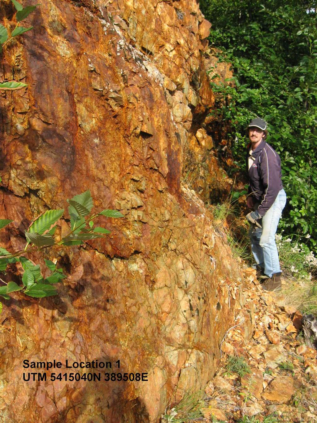
5 Technical Work Description Once it was established what roads could be used to access the claims with the help of Google Maps. A program of locating potential sites for the sampling of exposed bedrock and stream sediment that might yield values of precious metals was undertaken. Two main areas of iron ores were located and the co-ordinates recorded with a GPS device and samples were taken with hand tools and catalogued and removed for further analysis. The most interesting of these sites were photographed with a digital camera. After reviewing some of the previous reports that have been filed concerning this area and the previously staked claims that have since expired. I decided I should focus on the areas that it appears had not been previously sampled or assayed by the trenching, drilling or soil sampling programs of the past. Sample # UTM Co-ord. Description N Promising location of iron ore containing gold and silver, blue andesite E with large veins and crystals of metal, approximately 50 kg removed N More iron ore with pyrite and maybe copper values as green and blue E staining can be seen on exposed bedrock approximately 10 kg removed N Sample from bottom of waterfall where extensive quartz and calcite E stringers and veins were found in dark basalt approximately 5 kg N Large reclaimed area with more pyritic andesite approximately E 10 kg removed 4a N Iron ore appears to be pyritic andesite and siliceous andesite E approximately 10 kg removed N Roadside iron ore with cementation zones and a layer of blue and E white clay full of striated monoclinic crystals with a bright silver appearance approximately 250 kg removed N Pyritic andesite outcropping near stream 10 kg removed E 6a N Basalt with many stringers and vein of quartz and calcite occurring at E the contact zone between the andesite and basalt 10 kg removed
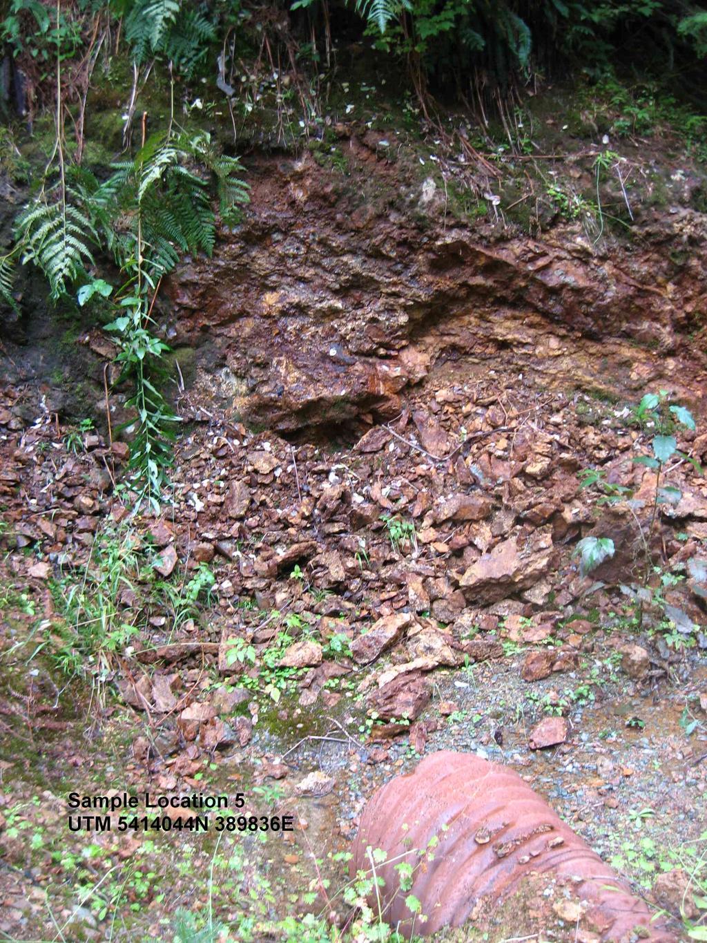
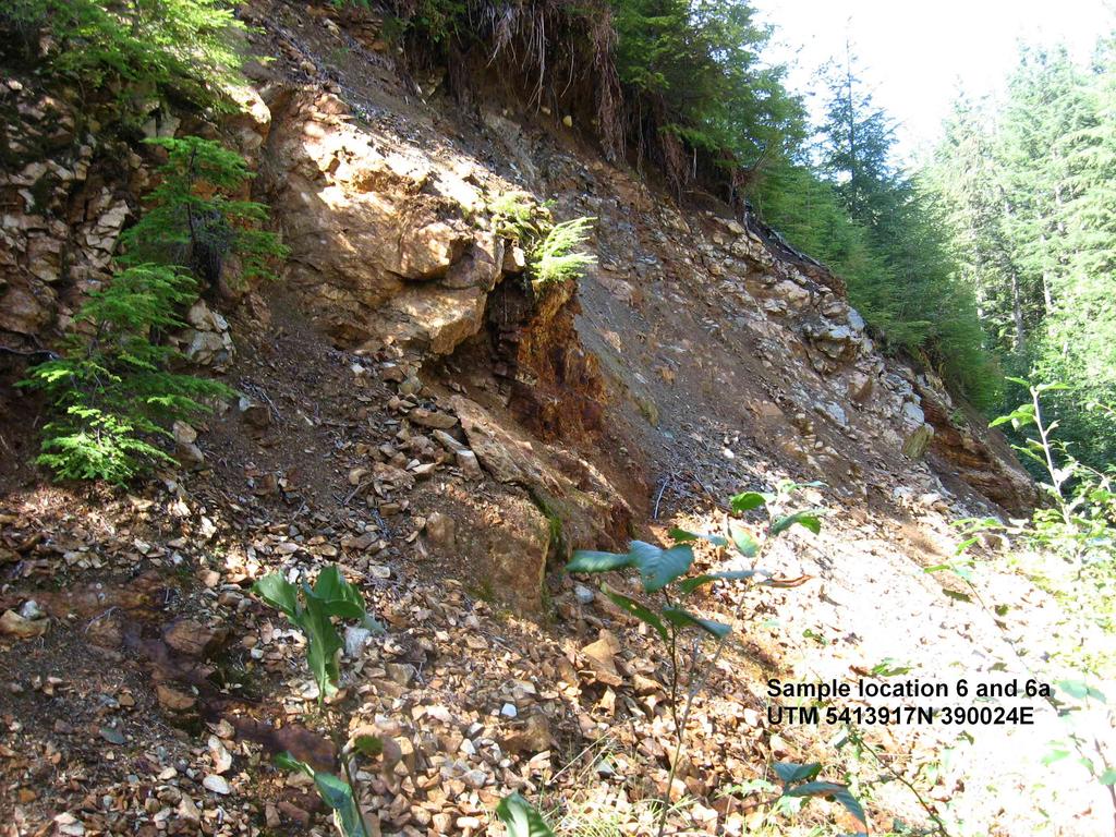
6 N Bedrock sample from under water table to prevent oxidation of E pyritic andesite at contact with basalt and quartz veins approximately 50 kg removed 7a N Sediment sample from sweeping out cracks in bedrock with a small E broom and whisk after prying apart sections of bedrock with a large steel bar approximately 30 kg removed 7b N Sediment sample from prying apart with a large steel bar and E hammer and chisel sections of basalt with calcite veins and sweeping it with a small broom and whisk approximately 40 kg removed N Black Argillite with rust in the seams approximately E 5 kg removed N Grey limestone with small black specks approximately 25 kg E removed
7 Equipment and Tools Used This program of sampling was carried out with hand tools. Hammers and chisels and various pry bars of different sizes were used to chip at bedrock and break open cracks and seams in the rock. Samples were then placed in buckets and labelled and backpacked to the nearest vehicle access points. Sediment samples were obtained the same way and swept with a small broom and shovel from the crevices in the bedrock and collected in buckets and labelled and backpacked to the nearest road. UTM co-ordinates were collected with a handheld Magellan explorist 100 GPS unit. Coordinates are generally accurate within 5 to 40 meters depending on the topography, interference from trees and weather conditions. Digital photographs were taken using a Canon PowerShot A540 Digital Camera.
8 Statement of Work and Cost This statement of work is for both events numbered and September people work from 10 am to 6pm totals 8 hours $25 spent on gas for vehicle. September people work from 10 am to 6 pm totals 8 hours $25 spent on gas for vehicle. October people work from 11 am to 6 pm totals 7 hours $20 spent on gas for vehicle. October people work from 11am to 2:30 pm totals 3.5 hours $10 spent on gas for vehicle. November people work from 10 am to 1 pm totals 3 hours $10 spent on gas for vehicle. Rates for Work Foreman worked for 29.5 $50.00 per hour equals $ Labourer worked for 29.5 $40.00 per hour equals $ Assistant Labourer worked for 3 $15 per hour equals $45.00 Total for work performed...$ Gas for Vehicle total...$90.00 Total expenses...$ Total value of Work for Event # $ Total value of Work for Event # $ I certify that this is true and correct Jan Dean M. Arbic
9 Conclusion and Interpretations The Raymond Creek area has a wide variety of potential locations for precious metal discoveries. The samples from this work will be studied and assayed and more sampling may be necessary. There may be enough base metals present to make it worthwhile for mining iron and copper as the prices of both ore are ever increasing. It can be concluded that a large iron formation is present, but whether or not the values of copper, silver or gold will make it profitable may be determined when these samples are assayed. Hardware Software and Qualifications and Sources GPS Unit... Magellan Explorist 100 Digital Camera...Canon PowerShot A540 This report was prepared using; OpenOffice.org 3.2 for all Text documents Paint.NET v for all sketches and for labelling photographs Maps were prepared using the MTO map viewer and recorded with Adobe software IBM Desktop computer with a Microsoft Windows XP Professional Version 2002 Service Pack 3 This report was written by Dean M Arbic who has a grade 12 education from Erindale Secondary School in Ontario. When previous work is mentioned it is referring to Aris Report 17164, "Geological and Drilling Report on the Archers I & 11 and Tatters II Mineral Claims" Nuspar Resources, Author Peter Fischl, B. Sc. February 1988.

10 Road and Trail Access Map Legend m. This map is a user generated static output from an Internet mapping site and is for general reference only. Data layers that appear on this map may or may not be accurate, current, or otherwise reliable. THIS MAP IS NOT TO BE USED FOR NAVIGATION. Notes: Solid Blue line is Logging roads still able to drive. Green solid line is Old roads and trails travelled on foot Map center: 48 51' 47" N, ' 54" W Scale: 1:29,166


11 Sample Location Map Legend m. This map is a user generated static output from an Internet mapping site and is for general reference only. Data layers that appear on this map may or may not be accurate, current, or otherwise reliable. THIS MAP IS NOT TO BE USED FOR NAVIGATION. Map center: 48 52' 22" N, ' 11" W Notes: Red Stars indicate locations where samples were collected Scale: 1:10,544

12

13

14
15

16

17

18

19

20
21
22

23

24
Technical Report. Geochemical Sampling West of Raymond Creek on Vancouver Island. Victoria Mining District 092C 15. UTM Co-ordinates N E
 Technical Report Geochemical Sampling West of Raymond Creek on Vancouver Island Victoria Mining District RECEIVED MINERAL TITLES BRANCH VANCOUVER, B.C. JAN 2 3 /i)13 L.l.g 092C 15 FILI NO. UTM Co-ordinates
PROSPECTING REPORT TENURES # / / CLAIM NAMES OLD SETTLER; OLD SETTLER1; OLD SETTLER2
 2010 PROSPECTING REPORT EVENT # 4820658 TENURES # 688183 / 691903 / 691905 CLAIM NAMES OLD SETTLER; OLD SETTLER1; OLD SETTLER2 COAST CRYSTALINE BELT REGION NEW WESTMINSTER MINING DISTRICT MAP - 092H GPS
PROSPECTING REPORT TENURES # / / CLAIM NAMES OLD SETTLER; OLD SETTLER1; OLD SETTLER2
 2011 PROSPECTING REPORT EVENT - 5160426 TENURES # 688183 / 691903 / 691905 CLAIM NAMES OLD SETTLER; OLD SETTLER1; OLD SETTLER2 COAST CRYSTALINE BELT REGION NEW WESTMINSTER MINING DISTRICT MAP - 092H GPS
Prospecting Report 'S Office i DB Property, B.C. -J Negro Creek Nelson Mining District NTS 82F.050. Operator: Kootenay Gold Inc.
 . '.' I"' i9 12 Prospecting Report 'S Office i DB Property, B.C. -J Negro Creek Nelson Mining District NTS 82F.050 Operator: Kootenay Gold Inc. Owner: Darlene Lavoie Work Performed Summer of 2007 Report
ASSESSMENT REPORT ON THE PEAVINE PROJECT. DGW & Associates # Alberni Street, Vancouver, British Columbia, V6E 4V2
 ASSESSMENT REPORT ON THE PEAVINE PROJECT KAMLOOPS MINING DIVISION BRITISH COLUMBIA NTS 082M 12 Latitude 51 36' 19.0"North -- Longitude --119 47' 27.0"West UTM Zone 11, NAD 83 5720827N 306744E Prepared
The Cobalt Rainbow. Airborne geophysical maps show that a north trending aeromagnetic high suggests further undiscovered mineralisation.
 The Cobalt Rainbow The property is located on Greenstone Creek, approximately 4.8 kilometres south west of the creek mouth. The property is located about 24 km due west of Campbell River, in the east-central
UNION MINIERE EXPLORATIONS AND MINING CORPORATION LIMITED ASSESSMENT REPORT ON FITINAT MINERAL CLAIM. Alberni Mining Division Record No.
 M F )( UNION MINIERE EXPLORATIONS AND MINING CORPORATION LIMITED Suite 200, 4299 Canada Way, Burnaby, B.C. V5G 1 H4 Telephone (604) 437-9491 ASSESSMENT REPORT ON GEOCHEMICAL SOIL SURVEYS AND ROCKSAMPLING
4J)SESSMEN'I' REPORT BRANCH. cc" FILE No: ASSESSMENT REPORT VICTORIA MINING DIVISION. Latitude 123O SF' Longitude 48O S5'
SESSMEN'I' REPORT BRANCH. cc FILE No: ASSESSMENT REPORT VICTORIA MINING DIVISION. Latitude 123O SF' Longitude 48O S5'") ASSESSMENT REPORT - ON THE ORM 1 MINERAL CLAIM VICTORIA MINING DIVISION NTS 92B cc" Latitude 123O SF' Longitude 48O S5' 3-2. w N C FILE No: @&@LOGI.CAL BRANCH 4J)SESSMEN'I' REPORT Date : June 1, 1990 TABLE
ASSESSMENT REPORT - ON THE ORM 1 MINERAL CLAIM VICTORIA MINING DIVISION NTS 92B cc" Latitude 123O SF' Longitude 48O S5' 3-2. w N C FILE No: @&@LOGI.CAL BRANCH 4J)SESSMEN'I' REPORT Date : June 1, 1990 TABLE
PROSPECTING REPORT PLACER CLAIM - FOX 4 SIMILKAMEEN MINING DIVISION MAP - 092H GPS COORDINATE REFERENCE CENTER OF CLAIM ' 6"N, 120.
 2011 PROSPECTING REPORT PLACER CLAIM - FOX 4 TENURE #793322 EVENT #5160421 SIMILKAMEEN MINING DIVISION MAP - 092H GPS COORDINATE REFERENCE CENTER OF CLAIM 49. 24' 6"N, 120. 36* 30" W REPORT PREPARED BY
PROSPECTORS ASSISTANCE PROGRAM MINISTRY OF ENERGY AND MINES
 BRITISH COLUMBIA PROSPECTORS ASSISTANCE PROGRAM MINISTRY OF ENERGY AND MINES GEOLOGICAL SURVEY BRANCH PROGRAM YEAR: 1999/2000 REPORT #: PAP 99-l 6 NAME: KIM ANSCHETZ PROSPECTORS TlEPORT on the 99 LOUIS
%+ '$# $) %, %*$ " $ $ ' %' !()'-!" %( %"%! " *'+ - % %$! $)! " $)!" !$ ' "! )( ! $ '%& ')- % % "!#( (( ((# $) ' ) ((* & *# ' % %"*# ( !!
 %, %*$ $ $ ' %' !()'-! %( %%! *'+ - % %$! $)! $)! !$ ' ! )( ! $ '%& ')- % % !#( (( ((# $) ' ) ((* & *# ' % %*# ( !!") 001L/14/0218 First Year Assessment Report of Prospecting, Rock and Stream Sediment Sampling On Licence 18880M, NTS 1L/14 Burin Peninsula Newfoundland and Labrador Submitted by: Keith Kelloway Work year:
001L/14/0218 First Year Assessment Report of Prospecting, Rock and Stream Sediment Sampling On Licence 18880M, NTS 1L/14 Burin Peninsula Newfoundland and Labrador Submitted by: Keith Kelloway Work year:
Montgomery Bedrock Geology 21d-Gowganda Formation: conglomerate, sandstone, siltstone, argillite
 Work Report 2014 Trenching Montgomery Township G-3303 Claim #4259384,4245818 Sault Ste. Marie Mining Division Michael & Yvon Gagne Montgomery Copper Property 1 P a g e 2 P a g e Montgomery Bedrock Geology
Hope Brook gold mine, NL - Copper, then switched to gold
 Chapter 12 : Mining in NL Defined as the extraction of valuable minerals from Earth from an ore body, vein, or seam. A mineral is any chemical substance arranged in some crystalline structure. - must have
1 FILMED 1. FILE NO:!..rsrru -* -. GRAND TWO CLAIM
 FILE NO:!..rsrru -* -. GRAND TWO CLAIM REPORT ON 1993 ASSESSMENT WORK GRAND TWO CLAIM REC. NO. 301849 NELSON MINING DIVISION NTS MAP SHEET 82F6/W 49 25'51" NORTH 117 18'08" WEST 1 FILMED 1 AUTHOR: R. Jordan,
The survey covered claims, in part or in full, DUCKLING 3, 4, 5, 4 fraction, and 5 fraction.
 514 687-6671 XXX- 602 West Hastin~a StroeP, Vata;sn@ouver, BritlsA fhlum~b~a, Garaadsa B81apphgtaa DISCUSS ION OF MAGNETOMETER SURVEY ON DUCKLING CLAIMS FOR DONNA MINES LTD. (N0P.L.) Submitted to: DONNA
SECOND and THIRD YEAR ASSESSMENT REPORT PROSPECTING LICENCE M, ROCK CUT PROPERTY, NTS 1N/12, NEWFOUNDLAND. ROY FRENCH (licence holder )
") SECOND and THIRD YEAR ASSESSMENT REPORT Of PROSPECTING On LICENCE 013704M, ROCK CUT PROPERTY, NTS 1N/12, NEWFOUNDLAND. By ROY FRENCH (licence holder ) Work Conducted: Sept. 17, 2008 Nov. 03, 2009 Total
SECOND and THIRD YEAR ASSESSMENT REPORT Of PROSPECTING On LICENCE 013704M, ROCK CUT PROPERTY, NTS 1N/12, NEWFOUNDLAND. By ROY FRENCH (licence holder ) Work Conducted: Sept. 17, 2008 Nov. 03, 2009 Total
GEOLOGICAL BRANCH ASSESSMENT REPORT 12. FItE NO: ACTION: THE GOLDEN MINING DIVISION, GOLDEN, Including THE NTS MAP; M82K/15W
 ACTION: FItE NO: Including 1990 GEO-CHEM SURVEY RESULTS -- THE AVD CLAIMS - THE GOLDEN MINING DIVISION, GOLDEN, B.C. NTS MAP; M82K/15W Lat. 50 deg. 55 Min. Long 116 deg. 55 min. For GEOLOGICAL BRANCH ASSESSMENT
ASSESSMENT REPORT GEOLOGICAL BRANCH. 50' 23 'North. GEOLOGICAL and GEOCHEMICAL SURVEYS ON THE. PUTNAM PROPERTY (Putnam Mineral Claim)
") GEOLOGICAL and GEOCHEMICAL SURVEYS ON THE PUTNAM PROPERTY (Putnam Mineral Claim) VERNON MINING DIVISION, B.C. GEOLOGICAL BRANCH ASSESSMENT REPORT NTS : Latitude: 82L17W 50' 23 'North LOCATION, ACCESS,
GEOLOGICAL and GEOCHEMICAL SURVEYS ON THE PUTNAM PROPERTY (Putnam Mineral Claim) VERNON MINING DIVISION, B.C. GEOLOGICAL BRANCH ASSESSMENT REPORT NTS : Latitude: 82L17W 50' 23 'North LOCATION, ACCESS,
GEOLOGICAL MAPPING REPORT ON THE ASH MINERAL CLAIM OSOYOOS MINING DIVISION ASHNOLA RIVER MAP SHEET NTS M092,H019 MCBRIDE CREEK AREA, ASHNOLA RIVER,
 GEOLOGICAL MAPPING REPORT ON THE ASH MINERAL CLAIM OSOYOOS MINING DIVISION ASHNOLA RIVER MAP SHEET NTS M092,H019 LATITUDE 49 o O6, LONGITUDE 120 o 22 MCBRIDE CREEK AREA, ASHNOLA RIVER, KEREMEOS, B.C. CANADA
ASX Announcement. 28 January Drill results indicate large Porphyry Copper Gold System at Peenam
 ASX Announcement 28 January 2010 Drill results indicate large Porphyry Copper Gold System at Peenam Highlights: 270 metres of visible copper (gold) mineralisation in first diamond core hole at Peenam Prospect
PROJECT DETAILS August 2014
 PROJECT DETAILS August 2014 Executive Summary InterGroup Mining Pty Ltd has a major gold exploration project located in North Queensland, Australia, in an underexplored high gold bearing district, west
NTS 082F03SW N W U E N
 Prospecting Report JOCELYN CLAIM NTS 082F03SW N49 09 51 W 117 14 04 11U 482906E 5445737N NELSON MINING DIVISION Martin Ross PO Box 323 Salmo BC V0G 1Z0 Jan 31, 2012 PROSPECTING REPORT JOCELYN MINERAL CLAIM
CONTENTS. Location, Access and History...6. Tenure Status and Geology Regional Andy Property Geology Map...9
 TYPE OFWORK IN THIS REPORT EXTENT OF WORK (rn METRTC UNITS) ON WHICH CLAIMS PROJECT COSTS APPORTIONED (incl. support) GEOLOGICAL (scale, area) Ground, mapping Photo interpretation GEOPHYSICAL (line-kilometres)
The MAPLE BAY PROJECT Copper Silver - Gold
 The MAPLE BAY PROJECT Copper Silver - Gold Good grade and tonnage potential within close proximity to Tidewater The Maple Bay Copper Silver Gold Project covers highly favourable geological host rocks of
Geoloqv Assessment ReDort. Heather ProDertv. Victoria Mining Division NTS 92C/15, 16
 Litr NO: 03 04 ACTION: RO. FILE No: Geoloqv Assessment ReDort Heather ProDertv Victoria Mining Division NTS 92C/15, 16 48' 59' N Latitude 124' 30' W Longitude Owner: Minnova Inc. Operator: Minnova Inc.,
Which sample best shows the physical properties normally associated with regional metamorphism? (1) A (3) C (2) B (4) D
 A (3) C (2) B (4) D") 1 Compared to felsic igneous rocks, mafic igneous rocks contain greater amounts of (1) white quartz (3) pink feldspar (2) aluminum (4) iron 2 The diagram below shows how a sample of the mineral mica breaks
1 Compared to felsic igneous rocks, mafic igneous rocks contain greater amounts of (1) white quartz (3) pink feldspar (2) aluminum (4) iron 2 The diagram below shows how a sample of the mineral mica breaks
POTENTIAL OF THE DONGWE COPPER GOLD PROJECT
 POTENTIAL OF THE DONGWE COPPER GOLD PROJECT By Nathan Sabao, P.Geo. September 2015 1 TABLE OF CONTENTS Page 1.0 EXECUTIVE SUMMARY 1 2.0 LOCATION 2 3.0 ACCESS 2 4.0 GEOLOGY 3 5.0 PREVIOUS DRILLING 5 6.0
GEOLOGIC REPORT. on the. NTS- 92 L/ 12 co-ords 50~37.5'~ 127~32'~ Owned by UTAH MINES LTD. GORDON MILBOURNE. Operator UTAH MINES LTD.
 GEOLOGIC REPORT on the " - SUNSET GROUP OF CLAIMS NTS- 92 L/ 12 co-ords 50~37.5'~ 127~32'~ Owned by UTAH MINES LTD. & GORDON MILBOURNE Operator UTAH MINES LTD. BY G.L. Holland Geol ogi st June 15, 1983
Practice Test Rocks and Minerals. Name. Page 1
 Name Practice Test Rocks and Minerals 1. Which rock would be the best source of the mineral garnet? A) basalt B) limestone C) schist D) slate 2. Which mineral is mined for its iron content? A) hematite
RECONNAISSANCE GEOCHEMICAL SURVEY
 RECONNAISSANCE GEOCHEMICAL SURVEY LEGAL, RITA, LOUISE FR. (CHAPLEAU GROUP) REVERTED CROWN GRANTS CHAPLEAU CREEK AREAJ, SLOC& MINING DIVISION 82 F/11W Lat: 49'44" Long: 117"22'W MINERAL RESOURCES BRANCH
GEOCHEMICAL REPORT ON THE YEP CLAIMS, Clinton Mining Division. P.E. Fox, PhD. P.Eng.
 CLNTON 1 MNNG RECORDER GEOCHEMCAL REPORT ON THE YEP CLAMS, Clinton Mining Division P.E. Fox, PhD. P.Eng. Fox Geological Consultants Ltd 204-635 Victoria St. Kamloops, B. C. August 5, 1974 Work done: Juge
Tameapa Regional Geology
 Tameapa Project 1 Tameapa Regional Geology History San Francisco Mines of Mexico Ltd. (San Francisco), which completed an exploration program, including six drill holes (1,157 m) between 1956 and 1959.
Location/Identification
 MINFILE Detail Report BC Geological Survey Ministry of Energy, Mines and Natural Gas and Responsible for Housing Location/Identification MINFILE Number: 092L 178 National Mineral Inventory Number: 092L14
GEOCHEMICAL REPORT LAST LINK GROUP TEXADA ISLAND NANAIMO MINING DIVISION
 I GEOCHEMICAL REPORT LAST LINK GROUP TEXADA ISLAND NANAIMO MINING DIVISION -1- PROSPECTING & GEOCHEMICAL SOIL SURVEY FOR GOLD On the Last Link Group of Claims North End of Texada Island Nanaimo Mining
Structural Analysis Using Hillshade Imagery. on the. LLC Property
 Structural Analysis Using Hillshade Imagery on the LLC Property Liard Mining Division NTS 104F/16W Latitude: 57 53' 47'' N Longitude: 132 03' 06'' W Owner Garry John Payie 3714 Raymond Street South, Victoria,
Lat. 52' 43' N Long ' W
 &A exploration ltd MINING ENGINEERING GEOLOGY- GEOPHYSICS 4570 HOSKINS ROAD, NORTH VANCOUVER, 6. C. TELEPHONE (804) 985,7921 V7K 2R1 GEOLOGICAL AND GEOCHEMICAL REPORT on the BLUE CLAIMS Cariboo Mining
We are committed to providing accessible customer service. If you need accessible formats or communications supports, please contact us.
 We are committed to providing accessible customer service. If you need accessible formats or communications supports, please contact us. Nous tenons à améliorer l accessibilité des services à la clientèle.
n3a 92 C- /.I 4 tr November 6, 1979 J. F. MclNTYRE, P.ENG. CONSU LTlNG MINING ENGl NEER Map #92C-16 TRANS PACIFIC VENTURES LTD.
 TELEPHONE : 5 9 6-1331 J. F. MclNTYRE, P.ENG. CONSU LTlNG MINING ENGl NEER 6466 CAGELDU CRESCENT DELTA, B.C. CANADA TRANS PACIFIC VENTURES LTD. c i. SAMPLING AND GEOPHYSICAL REPORT CAP CLAIM, VICTORIA
PROSPECTING REPORT. Medallion Property. EVENT # TENURE # Tenure Name: GPEX CLVIII Medallion
 2006-2007 PROSPECTING REPORT Medallion Property EVENT # 4167980 TENURE # 540362 Tenure Name: GPEX CLVIII Medallion Watson Bar Region Clinton Mining Division Map 092O Central Coordinate Reference Long.
compietea since tnat date, and wnicn comprisea btage I ot tne recommended
 compietea since tnat date, and wnicn comprisea btage I ot tne recommended four-stage program. GEOLOGY & MINERALIZATION The property situate6 on the southeast slope of Nickel Plate Mtn., and within the
For personal use only
 ANNOUNCEMENT TO THE AUSTRALIAN SECURITIES EXCHANGE: 28 NOVEMBER 2012 DRILLING UPDATE MABILO PROJECT The Directors of Sierra Mining Limited ( Sierra ) are pleased to announce further results from reconnaissance
2013 GEOLOGICAL ASSESSMENT REPORT SHERIDAN HILL PROPERTY
 2013 GEOLOGICAL ASSESSMENT REPORT ON THE SHERIDAN HILL PROPERTY NEW WESTMINSTER MINING DIVISION BRITISH COLUMBIA NTS 092G07 49 16 31 NORTH LATITUDE, 122 39 48 WEST LONGITUDE PREPARED FOR Sheridan Hill
We are committed to providing accessible customer service. If you need accessible formats or communications supports, please contact us.
 We are committed to providing accessible customer service. If you need accessible formats or communications supports, please contact us. Nous tenons à améliorer l accessibilité des services à la clientèle.
..!I AXE CLAIMS ON THE. for RICHCORE EXPLORATIONS LTO. GREENWOOD MINING DIVISION BRITISH COLUMBIA. Latitude 49O 30"; Longitude 118' 30'W NTS 82E/9W
 ON THE AXE CLAIMS for RICHCORE EXPLORATIONS LTO. GREENWOOD MINING DIVISION BRITISH COLUMBIA Latitude 49O 30"; Longitude 118' 30'W NTS 82E/9W... -... ~ i.,...._.'..!i Vancouver, B.C. September, 1980 P.
Magnetic Field and VLF Surveys on the Shining Tree Property. Claims: , , , , , , , ,
 December 29, 2014 NTS: 041P11 Magnetic Field and VLF Surveys on the Shining Tree Property Claims: 1203361, 4251801, 4251803, 4251805, 4263067, 4263068, 4270940, 4270436, 4276740 Churchill and Asquith Townships
1 CLAIMS GEOPHYSICAL REPORT ON BOYAL SITUATE NORTHEAST OF TILLICUM MOUNTAIN GOLD AREA BURTON - NAKUSP SIQCAEJ MINING DIVISION
 GEOPHYSICAL REPORT ON BOYAL 1 CLAIMS SITUATE NORTHEAST OF TILLICUM MOUNTAIN GOLD AREA BURTON - NAKUSP SIQCAEJ MINING DIVISION CONSULTING GEOLOGIST AUGUST 1983 VANCOUVER B *C INDEX INTRODUCTION ooa,.eoaaa.aaaoaaooaoa~ao~o
PROSPECTING REPORT. Silver Dollar Property. EVENT # TENURE # Tenure Name: GPEX Silver Dollar
 2008-2009 PROSPECTING REPORT Silver Dollar Property EVENT # 4267989 TENURE # 555462 Tenure Name: GPEX Silver Dollar Similkameen Mining Division Map 092H Central Coordinate Reference 120 06 26.9 W Longitude
Elverdton Copper-Gold Project Ravensthorpe, Western Australia
 FOR SALE or JV Elverdton Copper-Gold Project Ravensthorpe, Western Australia Summary: The Elverdton Copper-Gold Project is located approximately 11 kilometres south-east of Ravensthorpe town, which is
A PRELIMINARY REPORT ON THE ZYMOST2 CLAIM GROtP, TERRACE, B.C.
 NATIVE EXPLORATIONS LTD. A PRELIMINARY REPORT ON THE ZYMOST2 CLAIM GROtP, TERRACE, B.C. INTRODUCTION': The Zymoetz claim group is, at present, held under option by Native Explorations Ltd.. On the 19th
PRECIOUS METALS. owner. JMT Services Corp. GEOCHPlICAL SAMPLING CHELASLIE WCE, NORTH CENTRAL, B.C. OMINECA MINING DIVISION NTS 93F/5E & 6W
 PRECIOUS METALS REPORT ON 1980 RECONNAISSANCE GEOCHPlICAL SAMPLING CHELASLIE WCE, NORTH CENTRAL, B.C. OMINECA MINING DIVISION NTS 93F/5E & 6W LATITUDE 53O28 N LONGITUDE 125O31 W DATES Qp WORK: JULY 10
Negro Creek Fort Steele Minina Division. CRAIG KENNEDY Prospector
 AUG and SKAY Claims Negro Creek Fort Steele Minina Division NTS 82 F8/E Latitude 49O28 N Lonqi tude 116 Ol W BY CRAIG KENNEDY Prospector September 5, 1996 TABLE OF CONTENTS Page 1.00 INTRODUCTION 1.10
GEOLOGICAL FEATURES OF THE BADGER SPRINGS TRAIL FOR HIKERS Rev. 3,
 GEOLOGICAL FEATURES OF THE BADGER SPRINGS TRAIL FOR HIKERS Rev. 3, 12-3-02 http://ensayoes.com/docs/176/index-2111121.html Trail location The Badger Springs trail is just a short distance North of the
Sherlock drilling returns best intercept to date of 0.63% Cu and 7.45 g/t Ag over m
 NEWS RELEASE For immediate distribution Sherlock drilling returns best intercept to date of 0.63% Cu and 7.45 g/t Ag over 34.25 m All the five drill holes successfully intersected the mineralized stratigraphy
Geology 12 FINAL EXAM PREP. Possible Written Response Exam Questions
 Geology 12 FINAL EXAM PREP Possible Written Response Exam Questions Use this study guide to prepare for the written response portion of the final exam. Name FINAL EXAM - POSSIBLE WRITTEN RESPONSE QUESTIONS
DiaMine Exploration Inc. Pickle Lake Option Property
 DiaMine Exploration Inc. Pickle Lake Option Property Rock Sampling Program and Field Observations Claims 4249174, 4249175, 4249176 and 4249177, Kapkichi Lake Area (G-2081) And Claims 4249178, 4249179 and
for the Greenwood Mining Division, B.C. NTS 82E/7W Latitude 49' 27' W, Longitude 118' 5 Prepared by a= D. Dylan Watt, B.Sc.
 t. b LOGnO: 37~ -08 m. ACTIO#: for the AMP AMP 2 AMP 3 t AMP 4 CLAIMS Greenwood Mining Division, B.C. NTS 82E/7W Latitude 49' 27' W, Longitude 8' 5 %E c,w zc *& a w Prepared by a= -4c. D. Dylan Watt, B.Sc.
TOPOGRAPHICAL SURVEY REPORT ON THE GREENDROP PROPERTY NEAR CHILLIWACK, B.C. 92-H-3/W
 TOPOGRAPHICAL SURVEY REPORT ON THE GREENDROP PROPERTY NEW WESTMINSTER M.D. NEAR CHILLIWACK, B.C. 92-H-3/W Location: The central pap of the claims is located at coordinates 49 08'N, latitude by 121 26'W,
Summary of Rover Metals Geologic Mapping Program at the Up Town Gold Project, Northwest Territories
 October 13, 2017 Summary of Rover Metals Geologic Mapping Program at the Up Town Gold Project, Northwest Territories Vancouver, British Columbia, Canada - Rover Metals Corp., Rover, is pleased to provide
DISCOVERY OF MINERALISED PORPHYRY & MAGNETITE-COPPER-GOLD AT KAMARANGAN
 MEDUSA MINING LIMITED ABN: 60 099 377 849 Unit 7, 11 Preston Street Como WA 6152 PO Box 860 Canning Bridge WA 6153 Telephone: +618-9367 0601 Facsimile: +618-9367 0602 Email: admin@medusamining.com.au Internet:
lat ' N Long ' W
 305 7 ec1;, REPORT ON THE JERY CLAIMS OF POLA RESOURCES LTD. NTS 93L/16 0 0 lat. 54 45' N Long. 126 22' W BABIXE LAKE AREA OMINECA MINING DIVISION, B.C. PAUL PLICKA CONSULTING GEOLOGIST DECEMBER 30, 1981
LUCKY BEN MINE PROJECT SEPTEMBER 2018 UPDATE
 LUCKY BEN MINE PROJECT SEPTEMBER 2018 UPDATE During the first week of July 2018 work was completed by our Geologist, Richard Morris, and support personnel to stake the Lucky Ben vein structure at surface
ASSESSMENT REPORT TITLE PAGE AND SUMMARY
 ASSESSMENT REPORT TITLE PAGE AND SUMMARY TITLE OF REPORT: 2016 Prospecting Report Midas Claim TOTAL COST: $314.61 AUTHOR(S): Giacomo Grassi SIGNATURE(S): NOTICE OF WORK PERMIT NUMBER(S)/DATE(S): STATEMENT
We are committed to providing accessible customer service. If you need accessible formats or communications supports, please contact us.
 We are committed to providing accessible customer service. If you need accessible formats or communications supports, please contact us. Nous tenons à améliorer l accessibilité des services à la clientèle.
AiG ON THE EASTRIM mm. Record number KENNJZDY LAKE AREA - ALBERNI MINING DIVISION Map 92Fl3 W
 ON THE EASTRIM mm CLAIM Record number 3799 19 KENNJZDY LAKE AREA - ALBERNI MINING DIVISION Map 92Fl3 W 125" 23' West Lbngitude - 49" 09' North Latitude Walter GUPPY August ZO;i;! t I : AiG272002 TABLE
For personal use only
 ASX RELEASE 13 July 2012 ASX Code: PMQ Encouraging Field Exploration Results: Mount Borium Gold Project Key Points Third phase of field exploration underway the Company has been highly active since the
EXPLORATION and DEVELOPMENT REPORT. Conrad Creek. PLACER and MINERAL CLAIMS SOUTHEAST BRITISH COLUMBIA
 EXPLORATION and DEVELOPMENT REPORT on Conrad Creek PLACER and MINERAL CLAIMS in SOUTHEAST BRITISH COLUMBIA Ed Friesen, BSc.E.E., P. Eng 8 Lake Placid Rise SE Calgary, Alberta T2J 5B5 April 2009 1 P age
O ITHIS )WE OF WORK IN I EXTENT OF WORK I I PROJECT COSTS I ON WHICH CLAIMS (IN METRIC UNITS) APPORTIONED (id. support) GEOLOGICAL (scale, area)
WE OF WORK IN I EXTENT OF WORK I I PROJECT COSTS I ON WHICH CLAIMS (IN METRIC UNITS) APPORTIONED (id. support) GEOLOGICAL (scale, area)") Geological Survey Branch TITLE OF REPORT [type of SUNOY(S)] TOTAL COST 1 MINERAL INVENTORY M OWNER@) MAILING ADDRESS -.,-- a 5 -a OPERATOR(S) [who paid ffo the wnk) 2) MAILING ADDRESS 76e2 HWY 97/gm LP
Geological Survey Branch TITLE OF REPORT [type of SUNOY(S)] TOTAL COST 1 MINERAL INVENTORY M OWNER@) MAILING ADDRESS -.,-- a 5 -a OPERATOR(S) [who paid ffo the wnk) 2) MAILING ADDRESS 76e2 HWY 97/gm LP
Date Submitted: June General Nature of Report: Examination of Placer Samples
 General Nature of Report: Examination of Placer Samples Claim: Gold Channel, Record Number 3775!8 1 (Gold Channel Placer Property) Mining Division: Cariboo NTS 093 G 09 W and E Latitude 520 23 N' Longitude1210
SOUTHWEST & NORTHWEST EXPLORATION PROJECTS BINGHAM CANYON MINING DISTRICT
 SOUTHWEST & NORTHWEST EXPLORATION PROJECTS BINGHAM CANYON MINING DISTRICT SALT LAKE AND TOOELE COUNTIES, UTAH SUMMARY FRIDAY, MARCH 20, 2009 1 Tooele County Salt Lake County GOOGLE EARTH September, 2006
ASSESSMENT REPORT TITLE PAGE AND SUMMARY
 ASSESSMENT REPORT TITLE PAGE AND SUMMARY TITLE OF REPORT: 2016 Prospecting Report Sphynx Claim TOTAL COST: $167.56 AUTHOR(S): Giacomo Grassi SIGNATURE(S): NOTICE OF WORK PERMIT NUMBER(S)/DATE(S): STATEMENT
ASSESSMENT REPORT PROSPECTING PROGRAM ION/DIRTY JACK PROPERTY NELSON MINING DIVISION N.T.S. MAP SHEET 82F.023 UTM COORDINATES N E
 ASSESSMENT REPORT PROSPECTING PROGRAM ION/DIRTY JACK PROPERTY NELSON MINING DIVISION N.T.S. MAP SHEET 82F.023 UTM COORDINATES 5454800N - 0455235E Work Performed Summer 2007 OWNER >* ' Tom Kennedy >8 404-22
TITLE PAGE PROSPECTING REPORT. on the. Slil\lTINEL PEAK MINERAL CLAIM KENNEDY RIVER AREA. hlbehii1 MINING DIVISION NTS 92 F/6
 TITLE PAGE PROSPECTING REPORT on the Slil\lTINEL PEAK MINERAL CLAIM KENNEDY RIVER AREA hlbehii1 MINING DIVISION NTS 92 F/6 Latitude 49' 15' Longitude 125' 22' Walter Guppy Owner and operator TABLE OF COBTENTS
VANCOUVER, B.C. Tri 082F/ F/059
 GEOCHEMCAL REPORT t MAY L, 2006 Whbpper Mineral Claims Ailsa Lake Area Gold comm~ss16fl8f"s Offim on Mining Division VANCOUVER, B.C. Tri 082F/058 082F/059 3792 E 5486438 N Operator Kootenay Gold nc. Suite
Canadian National Railways tracks from the foot bridge across the. Thompson River from the Trans Canada Highway. A pick-up truck was used
 Canadian National Railways tracks from the foot bridge across the Thompson River from the Trans Canada Highway. A pick-up truck was used on the highway side and a h-wheel drive Jeep was transported by
Victoria Mining Division Vancouver Island, British Columbia
 6 7 Prospecting Report Exploration Activity Lucky M1039640 BC Geological Survey Assessment Report 36552 June 17/16, June 24, July 3, August 11, September 9 2016 Victoria Mining Division Vancouver Island,
MINFILE DETAILS. Occurrence Number: 105D 203 Occurrence Name: GRUMPY Occurrence Type: Hard-rock Status: Drilled Prospect
 MINFILE DETAILS Occurrence Number: 105D 203 Occurrence Name: GRUMPY Occurrence Type: Hard-rock Status: Drilled Prospect Aliases: Les 2 Deposit Type(s): Vein Polymetallic Ag-Pb-Zn+/-Au Location(s): 60 54'17.87"
DÉCOUVERTE Positioned for Discovery in James Bay, Quebec. Investor Presentation, January 2018 by Danae Voormeij, MSc, PGeo
 DÉCOUVERTE Positioned for Discovery in James Bay, Quebec Investor Presentation, January 2018 by Danae Voormeij, MSc, PGeo Location Maps and Infrastructure Location: Durango Resources 100% owned Découverte
Haoma Mining NL A.B.N
 Haoma Mining NL A.B.N 12 008 676 177 Registered Office & Head Office: 411 Collins Street, Melbourne, Vic., 3000, GPO Box 2282U, Melbourne, Vic., 3001. Telephone (03) 9629 6888, Facsimile (03) 9629 1250
Report of Gridding and Magnetic Surveys. On the. Munro Property. Munro and Beatty Townships, Ontario. Larder Lake Mining Division
 Report of Gridding and Magnetic Surveys On the Munro Property Munro and Beatty Townships, Ontario Larder Lake Mining Division Claims: 39 4244 For Big Red Diamond Corporation October 3, 2 Timmins, Ontario
IBI CORPORATION. GOLD and OTHER MINERAL EXPLORATION IN UGANDA
 IBI CORPORATION GOLD and OTHER MINERAL EXPLORATION IN UGANDA In the last two years, gold has taken on a renewed glitter, with a significant run-up in price. This aspect has obviously created the current
B) color B) Sediment must be compacted and cemented before it can change to sedimentary rock. D) igneous, metamorphic, and sedimentary rocks
 color B) Sediment must be compacted and cemented before it can change to sedimentary rock. D) igneous, metamorphic, and sedimentary rocks") 1. Which characteristic of nonsedimentary rocks would provide the least evidence about the environment in which the rocks were formed? A) structure B) color C) crystal size D) mineral composition 2. Which
1. Which characteristic of nonsedimentary rocks would provide the least evidence about the environment in which the rocks were formed? A) structure B) color C) crystal size D) mineral composition 2. Which
CJP EXPLORATION INC.
 PO Box 219 14579 Government Road Larder Lake, Ontario P0K 1L0, Canada Phone (705) 643-1122 Fax (705) 643-2191 CJP EXPLORATION INC. Spectrometer Survey Over the SHEBA PROPERTY Nouvel Township, Ontario TABLE
PHYSICAL WORK REPORT. the BAY CLAIMS. Omineca Mining Division Smithers, British Columbia N.T.S. 93E 13E/W
 PHYSICAL WORK REPORT the BAY CLAIMS Omineca Mining Division Smithers, British Columbia a N.T.S. 93E 13E/W LATITUDE: 53 57 00 N I LONGITUDE: 127 45 OO W for Home Ventures Ltd. 1201-675 West Hastings Street
EMPIRE DEVELOPMENT COMPANY LIMITED
 EMPIRE DEVELOPMENT COMPANY LIMITED 1017-736 Granville Street Vancouver 2, B.C. January 17, 1966 Chief Gold Commissioner, Department of Mines & Petroleum Reso,urces, Victoria, B.C. Dear Sir: The field work
A New Direction. Copper-Gold Deposit at Thor TSX.V:COL. August 11, May 2013
 A New Direction Copper-Gold Deposit at Thor August 11, 2016 May 2013 TSX.V:COL FORWARD LOOKING STATEMENTS This presentation includes certain forward-looking information or forward-looking statements for
ON THE LOST GOLD PROPERTY
 ON THE LOST GOLD PROPERTY NELSON MINING DIVISION BRITISH COLUMBIA Latitude: 49 18 North Longitude: 117 29.West TRIM MAPS: 82F1023,033 NTS: 8tF/5,6 By: Fred Critchlow . TABLE OF CONTENTS r PAGE lutroduction
SIXTH SCHEDULE REPUBLIC OF SOUTH SUDAN MINISTRY OF PETROLEUM, MINING THE MINING (MINERAL TITLE) REGULATIONS 2015
 REGULATIONS 2015") SIXTH SCHEDULE REPUBLIC OF SOUTH SUDAN MINISTRY OF PETROLEUM, MINING THE MINING ACT, 2012 THE MINING (MINERAL TITLE) REGULATIONS 2015 Guidelines should be prepared by the Directorate of Mineral Development
SIXTH SCHEDULE REPUBLIC OF SOUTH SUDAN MINISTRY OF PETROLEUM, MINING THE MINING ACT, 2012 THE MINING (MINERAL TITLE) REGULATIONS 2015 Guidelines should be prepared by the Directorate of Mineral Development
NTS 93L/9W GEOCHEMICAL AND GEOPHYSICAL REPORT MONA CLAIM OMINICA MINING DIVISION. Lati tude 54036'N; Longitude 'W
 GEOCHEMICAL AND GEOPHYSICAL REPORT ON MONA CLAIM OMINICA MINING DIVISION Lati tude 54036'N; Longitude 126018'W NTS 93L/9W April 1981 Paul Plicka Consulting Geologist LOCATION MAP INTRODUCTION TABLE OF
5. Compare the density of the oceanic crust to continental crust. 6. What kind of plate boundary is this? convergent
 The youngest rock is in the middle (at ridge) and it gets older on either side as you move away in a symmetrical pattern. 1. How does the age of the seafloor compare on either side of the ridge? A = youngest
32?un North of Hope, B.C.,
 Geological Reconnaissance Assessment Report on portions of the Gilt Creek Group (Mike, C.G., Julie, and Gilt Mineral Claims) Situated 32?un North of Hope, B.C., New Westminster Mining Division N 'P 97H/11W
DSM SYNDICATE DISCOVERS POLYMETALLIC MINERALIZATION WITH TALUS GRAB SAMPLES CONTAINING UP TO PERCENT LEAD AND 18
 DSM SYNDICATE DISCOVERS POLYMETALLIC MINERALIZATION WITH TALUS GRAB SAMPLES CONTAINING UP TO 92.8 GRAMS PER TONNE GOLD, 13,643 GRAMS PER TONNE SILVER, 13.85 PERCENT LEAD AND 18.65 PERCENT COPPER FROM DIFFERENT
L FILMED I GEOLOGICAL BRANCH ASSESSMENT REPORT. on the. in the. A Geological Report. situated. Nelson Mining Division
 A Geological Report on the GOV 5 Claim situated 4 km north of Creston, B.C. in the Nelson Mining Division N.T.S. 82pF/7tEf Lat: 49m1 N Long: 116'4.5'W 24.8' Dates of Work: 11-1 September 1986 Date of Report:
PROSPECTING REPORT THE WALLACE CLAIM OMENICA MINING DIVISION. 54" x6" 3.d d. for. Reako Exlorat ions Ltd. Wallace Rev. C.G.
 PROSPECTING REPORT ON THE WALLACE CLAIM OMENICA MINING DIVISION 54"44 14 1x6" 3.d d by David A. Howard P.Eng. for Reako Exlorat ions Ltd. Claim Locat ion Wallace Rev. C.G. #1560 Dome Mountain Area 9 3
PROSPECTING REPORT. re. Minera.1 C laims
 PROSPECTING REPORT re. Minera.1 C laims P R 1 Record #3052 (6) P R 2 Record #3053 (6) p R 3 Record #3054 (6) at Ilong.129, Latt. 58 20' in the Two Mile Creek area of Turnagain River drainage system in
PIOTR LUTYNSKI VANCOUVER, BRITISH COLUMBIA
 AN ASSESSMENT REPORT ON GROUND MAGNETIC SURVEYING CHUCHI PROPERTY FORT ST. JAMES AREA, BRITISH COLUMBIA OMINECA M.D. 55 17 N, 124 31 W NTS 93N/ 7&8 Claims Surveyed: 597976, 597878-597880 Survey Dates:
GEOPHYSICAL ASSESSMENT REPORT (TOP & BOTTOM CLAIMS) MCINTYRE LAKE. VERNON MINING DIVISION, B-Cm
 MCINTYRE LAKE. VERNON MINING DIVISION, B-Cm") GEOPHYSICAL ASSESSMENT REPORT on the TOP PROPERTY (TOP & BOTTOM CLAIMS) MCINTYRE LAKE VERNON MINING DIVISION, B-Cm NTS : Latitude: 50'04' North Longitude: Owner: Consultant : Author : 118'33 ' West Brican
GEOPHYSICAL ASSESSMENT REPORT on the TOP PROPERTY (TOP & BOTTOM CLAIMS) MCINTYRE LAKE VERNON MINING DIVISION, B-Cm NTS : Latitude: 50'04' North Longitude: Owner: Consultant : Author : 118'33 ' West Brican
ASSESSMENT WORK REPORT ONTARIO MINING CLAIM TB THUNDER BAY MINING DIVSISION ONTARIO, CANADA. Report written by R.A. HIETAPAKKA for G.L.
 2.56189 2015 ASSESSMENT WORK REPORT ONTARIO MINING CLAIM TB3007723 THUNDER BAY MINING DIVSISION ONTARIO, CANADA PROwN ;1,AL RECORDING OFF'CE SUDBURY RE'''TIVED AUG 2 0 2015 AM. P.M. 718191/011412111213141516_
Section 5. Rock Units and Your Community. What Do You See? Think About It. Investigate. Learning Outcomes
 Chapter 3 Minerals, Rocks, and Structures Section 5 Rock Units and Your Community What Do You See? Learning Outcomes In this section, you will Recognize that rocks are arranged in Earth s crust as well-defined
RR#7 - Free Response
 Base your answers to questions 1 through 3 on the table below and on your knowledge of Earth science. The table shows the elements and their percent compositions by mass in the five minerals present in
CERRO PRIETO PROJECT MINERAL CONCESSIONS LOCATION AND ACCESS
 Cerro Prieto CERRO PRIETO PROJECT MINERAL CONCESSIONS The Cerro Prieto Project is comprised of three mining exploitation concessions encompassing 2,723 hectares in northern Sonora, Mexico. Oroco holds