2015 University of Manitoba Geophysics Field School Selkirk Golden Boy Project: Introduction and Field Work Date: May 1-2, 2015
|
|
|
- Gerard Walton
- 5 years ago
- Views:
Transcription
 data from the Golden Boy Project near Selkirk, Manitoba.")
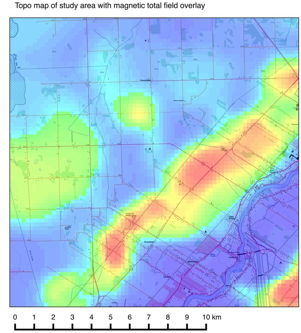
1 2015 University of Manitoba Geophysics Field School Selkirk Golden Boy Project: Introduction and Field Work Date: May 1-2, 2015 This project will involve measurement, analysis, and interpretation of potential field (gravity and magnetic) data from the Golden Boy Project near Selkirk, Manitoba. The gravity and magnetic anomalies associated with the project are two of the strongest isolated potential field anomalies in southern Manitoba: the gravity anomaly is 380 GU and the magnetic anomaly is ~800 nt. The Precambrian rocks presumed to be responsible for the anomalies lie beneath m of Paleozoic cover and ~20 m of surficial deposits. The anomalies were examined by Pro Am Explorations Corporation as a possible exploration target in the 1990s; one of the major participants was Dr Bill Brisbin. Work on the project will involve (i) Introductory material on the geology, geophysics, and history of the Golden Boy Prospect. (ii) Planning and completion of a detailed magnetic survey across the western limb of the anomaly. (iii) Gravity (plus elevation) and possibly EM34 survey along the magnetic profile. (vi) Modelling, interpretation, and geological synthesis. The primary question we wish to answer is: what is the sub-surface geological structure responsible for the observed magnetic and gravity anomalies? Bouguer anomaly for southern Manitoba. The Golden Boy anomaly lies along the Red River just south of Lake Winnipeg,

2 Shaded-relief plot of the magnetic total field. The Golden Boy feature is a pair of linear anomalies trending SW-NE. The main component of the geophysical survey is a magnetometer survey along Hwy. 67, approximately 5 km south of Selkirk and 3 km north of Lockport. We will survey a 4 km long profile with the aim of taking sufficiently dense measurements to characterize the lateral magnetic variations in the underlying Precambrian units (allowing correlation with projected borehole data). On the second day of the project we will complete the survey and possibly add readings along additional lines on nearby roads: survey planning will be based on the results from the first day. The first survey method is magnetics. Magnetic measurements should be made every 25 m along the road with the side of the road chosen so as to minimize the effects of cultural features. Temporal magnetic variations will be a source of noise in the magnetic survey. Prior to departing for the field you should examine the magnetic forecast and recent field variations on the internet. In order to allow for possible correction of the data for time-variations, it is critical to record the time of each magnetic measurement. It will be useful to make base-station readings every hour to monitor the level of field variations. It is also critical to note the presence of any cultural features along the profile that may have affected the magnetic readings (e.g. culverts, power line crossings, parked cars etc). You should also be recording the position of major cultural features such as road intersections. The second survey method is gravity and associated elevation readings. Gravity measurements should be made at 200 m intervals along the survey line with the elevation, GPS location, instrument height,
3 and time of each reading noted. You will need to establish a base-station that should be revisited every hour to two hours. It is critical for the readings at the base station to be as accurate as possible. Schedule Friday, May 1 09:00-9:30 Introduction to history, geology, and geophysics of region by Dr. Bill Brisbin 09:30-10:30 Planning session and magnetic forecast checking. 10:30 Depart for Selkirk 11:30-13:00 Gravity, elevation, and magnetic surveys. 13:00-13:45 Lunch in Selkirk or Lockport 13:45-16:00 Gravity, elevation, and magnetic surveys 16:00 Depart for Winnipeg 17:00-17:30 Put batteries on charge, end of day Friday, May 1 st 08:30-09:00 Planning, instrument preparation, packing, magnetic forecast checking. 09:15 Depart for Selkirk 10:15-12:30 Gravity, elevation, magnetic surveys. 12:30-13:15 Lunch in Selkirk or Lockport 13:00-16:00 Gravity, elevation, magnetic surveys 16:00 Depart for Winnipeg 17:00-17:30 Put batteries on charge, end of day Saturday, May 2 nd 08:30-14:00 Data reduction, plotting, and qualitative interpretation 14:00-18:00 Magnetic and gravity modelling 18:00-21:00 Magnetic and gravity modelling Sunday, May 3 rd 08:30-10:30 Magnetic and gravity modelling 10: Integrated data interpretation and project report. Equipment We will need all the equipment for the following methods : 1. Magnetometers (we have three modern units available, one of which measures the gradient) 2. Gravity, with spare batteries and bulbs, and elevation 3. Three GPS units and numerous survey tapes Groups For this survey there will be three data acquisition groups, working co-operatively. You will be expected to help plan and to coordinate the survey yourselves, ensuring that everyone participate in all methods. Given the distances involved in the survey, it will be important to coordinate the use of the three vehicles e.g. picking the gravimeter and magnetometer up for the base station recordings. Name Group Data pair Dhatt, Amandeep 1 1a Sato, Easton 1 1a Naseem, Qaisar 1 1a Mann, Harsimran 1 1b Ulom, Tony 1 1b
4 Ishola, Sodiq 2 2a Gill, Shehryar 2 2a Tyomkin, Yana 2 2b Clark, Neil 2 2b Ramlakhan, Kevin 3 3a Cornick, Jason 3 3a Kachappilly, Steve 3 3b Ibikunle, Gafaar 3 3b Data Analysis All data should be appropriately archived and should be completed on the evening of Saturday 28 th April. Data archiving will be done by each group for the data they collected. At this point the whole data set will be made available to the class. Instructions for the data reduction and analysis will be provided following the data archiving. The gravity and magnetic data reduction and basic plotting of results will be done in the groups of four people. More advanced modelling and the writing up will be done in pairs. As this project is intended to be a realistic geophysical project I will expect a (typed) project report at the end containing a brief description of: the project aim, site information, and site history; a summary of surveys performed; description of results, analysis, and interpretation. A report is to be prepared by each data analysis pair. All material to be submitted by 6:00 PM, Monday, May 4 th.

5
6
440 Geophysics: Fieldtrip guide for Death Valley, April 2005
 440 Geophysics: Fieldtrip guide for Death Valley, April 2005 Thorsten Becker; Jeff Hoeft University of Southern California Objective We will be performing a gravity and several seismic surveys from Friday
a z41. COMMONWEALTH OF AUSTRALIA DEPARTMENT OF NATIONAL DEVELOPMENT BUREAU OF MINERAL RESOURCES, GEOLOGY AND GEOPHYSICS RECORD 1961 No.
 a z41. COMMONWEALTH OF AUSTRALIA ff..4 *.re /Veis DEPARTMENT OF NATIONAL DEVELOPMENT BUREAU OF MINERAL RESOURCES, GEOLOGY AND GEOPHYSICS RECORD 1961 No. 66 RED TANK BORE GRAVITY SURVEY, PLENTY RIVER, N.T.
We are committed to providing accessible customer service. If you need accessible formats or communications supports, please contact us.
 We are committed to providing accessible customer service. If you need accessible formats or communications supports, please contact us. Nous tenons à améliorer l accessibilité des services à la clientèle.
Geothermal Energy Resources Exploration using Gravity and magnetics. By Mariita, N.O. KenGen
 Geothermal Energy Resources Exploration using Gravity and magnetics By Mariita, N.O. KenGen What is Geothermal Energy? Geothermal Energy = heat from the Earth Transmitted by fluids via fractures and pores
Department of Geophysics Faculty of Earth Sciences King Abdulaziz University
 Department of Geophysics Faculty of Earth Sciences King Abdulaziz University Dr. Mansour A. Al-Garni Office: room 233/Buld. 27 OR Dept. chair office/buld. 55 Introduction to Geophysics EGP 211 Time: 10-10:55
Final Review session 2
 Environmental and Exploration Geophysics I Final Review session 2 tom.h.wilson tom.wilson@mail.wvu.edu Department of Geology and Geography West Virginia University Morgantown, WV Reminders Turn in magnetics
QUALITATIVE INTERPRETATION OF POTENTIAL FIELD PROFILES: SOUTHERN NECHAKO BASIN
 QUALITATIVE INTERPRETATION OF POTENTIAL FIELD PROFILES: SOUTHERN NECHAKO BASIN By Melvyn E. Best Bemex Consulting International 5288 Cordova Bay Road Victoria, B.C. V8Y 2L4 KEYWORDS: potential fields,
Geophysical surveys Anomaly maps 2D modeling Discussion Conclusion
 Introduction Geophysical surveys Anomaly maps 2D modeling Discussion Conclusion General context Growth of volcanic domes is a multiphase process: extrusion phases 2005 lava dome growth inside the Mount
GRAVITY AND MAGNETIC METHODS
 Presented at Short Course IX on Exploration for Geothermal Resources, organized by UNU-GTP, GDC and KenGen, at Lake Bogoria and Lake Naivasha, Kenya, Nov. 2-24, 2014. Kenya Electricity Generating Co.,
INTRODUCTION TO APPLIED GEOPHYSICS
 INTRODUCTION TO APPLIED GEOPHYSICS EXPLORING THE SHALL0W SUBSURFACE H. Robert Burger Anne F. Sheehan Craig H.Jones VERSITY OF COLORADO VERSITY OF COLORADO W. W. NORTON & COMPANY NEW YORK LONDON Contents
We are committed to providing accessible customer service. If you need accessible formats or communications supports, please contact us.
 We are committed to providing accessible customer service. If you need accessible formats or communications supports, please contact us. Nous tenons à améliorer l accessibilité des services à la clientèle.
224 D4 Instrumentation and data collection techniques for magnetic exploration
 224 D4 Instrumentation and data collection techniques for magnetic exploration D4.1 Instrumentation D4.1.1 Flux gate magnetometer Details of operation are described in Keary and Brooks Measures the component
Archaeology and Geophysics at the Chillicothe Site, Ohio, USA
 info@gemsys.on.ca Archaeology and Geophysics at the Chillicothe Site, Ohio, USA In this short paper, we summarize the recent procedings of the National Parks Service Archaeology Workshop in Chillicothe,
Available online Journal of Scientific and Engineering Research, 2016, 3(2):1-7. Research Article
:1-7. Research Article") Available online www.jsaer.com, 2016, 3(2):1-7 Research Article ISSN: 2394-2630 CODEN(USA): JSERBR Assessment of the Reliability of Magnetic Method to Delineate Geologic Features in a Basement Complex:
Available online www.jsaer.com, 2016, 3(2):1-7 Research Article ISSN: 2394-2630 CODEN(USA): JSERBR Assessment of the Reliability of Magnetic Method to Delineate Geologic Features in a Basement Complex:
C5 Magnetic exploration methods data analysis techniques
 C5 Magnetic exploration methods data analysis techniques C5.1 Data processing and corrections After magnetic field data have been collected a number of corrections are applied to simplify the interpretation.
Darnley Bay Resources Preliminary Airborne Survey Results
 4 King Street West, Suite 1103 Toronto, Ontario M5H 1B6, Canada Tel:(416) 862-7885 Fax:(416) 862-7889 dbr@darnleybay.com UPDATE Trading Symbol: DBL. TSX Venture Exchange April 19, 2010 Darnley Bay Resources
GRAVITY AND MAGNETIC SURVEY NECHAKO BASIN STUDY ACQUISITION AND PROCESSING PHASE
 GRAVITY AND MAGNETIC SURVEY NECHAKO BASIN STUDY ACQUISITION AND PROCESSING PHASE Report prepared for the B.C. Ministry of Energy and Mines Resource Development Division New Ventures Branch by Bemex Consulting
Geophysics for Environmental and Geotechnical Applications
 Geophysics for Environmental and Geotechnical Applications Dr. Katherine Grote University of Wisconsin Eau Claire Why Use Geophysics? Improve the quality of site characterization (higher resolution and
Ni-Cu-Au-U TYPE AIRBORNE ANOMALIES OUTLINED
 ABN 28 122 180 205 www.juttholdings.com ASX ANNOUNCEMENT (ASX Code: JUT) 29 February 2008 Ni-Cu-Au-U TYPE AIRBORNE ANOMALIES OUTLINED Tay - Munglinup Project: near Ravensthorpe in the SW of Western Australia
Spring 2018 Drill Program
 VANCOUVER, BC / April 5, 2018 / Margaret Lake Diamonds Inc. (TSX-V: DIA; FSE: M85) ("Margaret Lake" or the "Company") is pleased to report preparations are now underway to commence a diamond drill program
GEOTHERMAL POTENTIAL OF ST. KITTS AND NEVIS ISLANDS
 GEOTHERMAL POTENTIAL OF ST. KITTS AND NEVIS ISLANDS By Gerald W. Huttrer Geothermal Management Company, Inc. For the Eastern Caribbean Geothermal Energy Project ( Geo- Caraibes ; G-C ) Presented Using
We are committed to providing accessible customer service. If you need accessible formats or communications supports, please contact us.
 We are committed to providing accessible customer service. If you need accessible formats or communications supports, please contact us. Nous tenons à améliorer l accessibilité des services à la clientèle.
The Discovery of the Phoenix: New High-Grade, Athabasca Basin Unconformity Uranium Deposits Saskatchewan, Canada
 The Discovery of the Phoenix: New High-Grade, Athabasca Basin Unconformity Uranium Deposits Saskatchewan, Canada FORWARD LOOKING STATEMENT Some disclosure included in this presentation respecting production,
Seismic Reflection Imaging across the Johnson Ranch, Valley County, Idaho
 Seismic Reflection Imaging across the Johnson Ranch, Valley County, Idaho Report Prepared for the Skyline Corporation Lee M. Liberty Center for Geophysical Investigation of the Shallow Subsurface (CGISS)
Gravity data reduction
 Gravity data reduction REDUCTION: raw data à gravity anomaly data Temporal corrections tides and instrument drift Spatial corrections latitude and elevation GRS67 = gravity variation with latitude at sea
Integrated Interpretation of Gravity, Magnetic & Seismic data for delineation of Basement Configuration in Sadiya Block, Upper Assam, India
 P-225 Integrated Interpretation of Gravity, Magnetic & Seismic data for delineation of Basement Summary G.K.Ghosh *, S.K.Basha, V.K. Kulshreshth Gravity and magnetic data were collected jointly by National
Harvey Thorleifson, Director, Minnesota Geological Survey. Status of geological mapping needed for groundwater protection in Minnesota
 Harvey Thorleifson, Director, Minnesota Geological Survey Status of geological mapping needed for groundwater protection in Minnesota Minnesota is located between the Dakotas and Wisconsin, north of Iowa,
High Resolution Geophysics: A Better View of the Subsurface. By John Jansen, P.G., Ph.D., Aquifer Science and Technology
 High Resolution Geophysics: A Better View of the Subsurface By John Jansen, P.G., Ph.D., Aquifer Science and Technology Geologist Use Only Part of the Information Available To Them Most Geologist rely
Reconnaissance. Of the. Denis mineral claims. Situated at Kilometer 844 of the Alaska Highway. Liard Mining Division. Northeastern British Columbia
 Reconnaissance Of the Denis mineral claims Situated at Kilometer 844 of the Alaska Highway Liard Mining Division Northeastern British Columbia N.T.S. 94M.075 Latitude 59 42 25 Longitude 127 13 12 Field
Junior Uranium explorer in the Athabasca Basin. Patterson Claims
 Junior Uranium explorer in the Athabasca Basin Patterson Claims Cautionary Note Regarding Forward-Looking Statements This Presentation and the exhibits attached herein contain forward-looking statements
EIS sponsored Diamond drilling to commence at Zanex
 L efroy ASX Announcement LEFROY EXPLORATION LIMITED Western Australian Focused Gold Explorer ASX Code: LEX Shares on Issue: 64.5m Current Share Price: 16.5c Market Capitalisation: $10.6m Board of Directors
Discovering Canadian Gold and Diamonds. Oxford Lake Project, Manitoba
 Discovering Canadian Gold and Diamonds Oxford Lake Project, Manitoba March 2016 Forward Looking Statement Certain statements contained in this presentation may contain forward-looking information within
Darien Resources Inc.
 RECEIVED MAR 3 0 2e05 GEOSCIENCE,4 SSESSMENT OffI CE: DARIEN RESOURCES INC. ASSESSMENT WORK REPORT PERIOD MAY 20 - MAY 24, 2004 PRONTO BAY, NORTHERN LAKE HURON REPORT COMPLETION DATE: MARCH 2005 Charles
Principles of Applied Geophysics
 Principles of Applied Geophysics Fifth edition D.S. Parasnis Professor emeritus of Applied Geophysics Department of Applied Geophysics, University ofluled, Lulea, Sweden Fellow of the Royal Swedish Academy
For personal use only
 31 January 2012 Manager of Company Announcements ASX Limited Level 6, 20 Bridge St Sydney NSW 2000 By E-Lodgement Cassini Resources Limited December 2011 Quarterly Report This is Cassini Resources Limited
For personal use only
 Investor Presentation 2012 Home of Bullion Shane Mele Executive Director April 2012 1 2012 Update 1. Barrow Creek, NT - Aquired Advanced Copper Project 2. Blind Calf, NSW - Previous High Grade Copper Intercepts,
Trip and Parking Generation Study of Orem Fitness Center-Abstract
 Trip and Parking Generation Study of Orem Fitness Center-Abstract The Brigham Young University Institute of Transportation Engineers student chapter (BYU ITE) completed a trip and parking generation study
Geophysics and Mapping. presented by: Stephen Brown
 Geophysics and Mapping presented by: Stephen Brown Recommended book for INIGEMM Geophysics for the mineral exploration geoscientist, by Michael Dentith and Stephen Mudge, Cambridge University Press, 2014.
PROSPECTING REPORT TENURES # / / CLAIM NAMES OLD SETTLER; OLD SETTLER1; OLD SETTLER2
 2011 PROSPECTING REPORT EVENT - 5160426 TENURES # 688183 / 691903 / 691905 CLAIM NAMES OLD SETTLER; OLD SETTLER1; OLD SETTLER2 COAST CRYSTALINE BELT REGION NEW WESTMINSTER MINING DISTRICT MAP - 092H GPS
GRAVITY EXPLORATION (Gph 301) Chokri Jallouli 2014/2015
 Chokri Jallouli 2014/2015") KING SAUD UNIVERSITY FACULTY OF SCIENCES Department of Geology and Geophysics GRAVITY EXPLORATION (Gph 301) Chokri Jallouli 2014/2015 INTRODUCTION Definition Gravity method consists of measuring, studying
KING SAUD UNIVERSITY FACULTY OF SCIENCES Department of Geology and Geophysics GRAVITY EXPLORATION (Gph 301) Chokri Jallouli 2014/2015 INTRODUCTION Definition Gravity method consists of measuring, studying
on the COMINCO LTD. WESTERN DISTRICT EXPLORATION N.T.S. 94L/3E GEOPHYSICAL SURVEYS LATITUDE: 58' 12' N; LONGITUDE: 127' 10' W
 COMNCO LTD. EXPLORATON N.T.S. 94L/3E WESTERN DSTRCT GEOPHYSCAL SURVEYS on the WEST GROUP, FROG RVER PROPERTY KECHKA AREA, LARD MNNG DVSON, B.C. LATTUDE: 58' 12' N; LONGTUDE: 127' 10' W WORK PERFORMED:
September 16, 2010 Magnetic surveying
 September 16, 2010 Magnetic surveying After today, you will be able to Sketch anomalies over objects at any location, and explain how you derived the pattern. Explain the relation between dipoles and real
GREATLAND GOLD PLC (AIM:GGP) ERNEST GILES PROJECT - EASTERN YILGARN
 ERNEST GILES PROJECT - EASTERN YILGARN") GREATLAND GOLD PLC (AIM:GGP) ERNEST GILES PROJECT - EASTERN YILGARN Ownership Greatland Pty Ltd 100% Area 1,800 square kilometres Licences E38/2204 Calanchini Granted E38/2882 Carnegie Granted E38/3183
GREATLAND GOLD PLC (AIM:GGP) ERNEST GILES PROJECT - EASTERN YILGARN Ownership Greatland Pty Ltd 100% Area 1,800 square kilometres Licences E38/2204 Calanchini Granted E38/2882 Carnegie Granted E38/3183
High-resolution magnetic mapping of contaminated sediments in urbanized environments
 High-resolution magnetic mapping of contaminated sediments in urbanized environments JOE BOYCE, MATT POZZA, and BILL MORRIS, McMaster University, Hamilton, Ontario, Canada The remediation of contaminated
PRESENTATION TITLE. Drone Magnetic Site Surveys To Verify Wellhead Locations David M. Velozzi 9/27/18
 1 PRESENTATION TITLE Drone Magnetic Site Surveys To Verify Wellhead Locations David M. Velozzi 9/27/18 Speaker Information David M. Velozzi Geoscience Team Lead Magnetic Variation Services (MagVAR) (A
Field Trip Overview Map
 CEETEP Field Trip Guide October 11, 2014 Cascadia Subduction Zone CASCADE VOLCANOES COAST RANGE North American Plate get Pu Juan De Fuca Ridge & tte Locked Zone Earthquake me MID-OCEAN RIDGE lla Pacific
For personal use only
 ASX ANNOUNCEMENT 26 October 2011 5 TENEMENTS PEGGED FOR SANDSTONE HOSTED URANIUM AT PONTON Enterprise Metals Limited ( Enterprise or the Company, ASX: ENT ) wishes to announce that it s 100% owned subsidiary
Detailed Low-Induction-Number EM Sounding to 9-m Depth
 Detailed Low-Induction-Number EM Sounding to 9-m Depth Richard S. Taylor, Dualem Inc. J. Scott Holladay, Geosensors Inc. David Lalonde, Geosensors Inc. SAGEEP, Charleston SC, April 11 Copyright 11, Dualem
Record of Mathematics. Issue 1
 Record of Mathematics Issue 1 Calendar for Week 2 of Root Class at MathILy: A reminder of our weekday-ly schedule: Breakfast 8:15 8:55 at Erdman Morning class 9:00 1:00 in Park 336, 337, and 328 Lunch
COPPER REEF Mining Corporation. July 18, 2018
 COPPER REEF Mining Corporation Analyses of Airborne South and West of Alberts Lake Anomalies July 18, 2018 R.W. Groom, PhD,BMath Petros Eikon Incorporated Orangeville, ON Stephen Masson, M.Sc., P.Geo.
GEOSYNTEC CONSULTANTS
 GEOSYNTEC CONSULTANTS 2100 Main Street, Suite 150 Huntington Beach, CA 92648 USA Tel (714) 969-0800 Fax (714) 969-0820 15 February 2006 Ms. Tamara Zeier, P.E. Project Manager Project Navigator, Ltd. One
KARST MAPPING WITH GEOPHYSICS AT MYSTERY CAVE STATE PARK, MINNESOTA
 KARST MAPPING WITH GEOPHYSICS AT MYSTERY CAVE STATE PARK, MINNESOTA By Todd A. Petersen and James A. Berg Geophysics Program Ground Water and Climatology Section DNR Waters June 2001 1.0 Summary A new
Geophysical Survey. Ballymount Co. Dublin. Licence Ref. 02R029. By John Nicholls Margaret Gowen & Co. Ltd. For LRT
 Geophysical Survey Ballymount Co. Dublin Licence Ref. 02R029 By John Nicholls Margaret Gowen & Co. Ltd. For LRT 4 th April 2002 Illustrations List of Figures Figure 1 Site Location 1: 50000 Figure 2 Survey
Professional Development Grant Final Report. Attend and Present at the Annual Meeting of the Geological Society of America
 Professional Development Grant Final Report Attend and Present at the Annual Meeting of the Geological Society of America Michael G. Davis, Ph.D. Department of Physical Sciences College of Natural and
Parking Study MAIN ST
 Parking Study This parking study was initiated to help understand parking supply and parking demand within Oneida City Center. The parking study was performed and analyzed by the Madison County Planning
Copper Reef to Drill Massive Sulphide Targets in Flin Flon
 12 Mitchell Road Tel: (204) 687-3500 Flin Flon, MB, R8A 1N1 CZC.CSE Fax: (204) 687-4762 copperreef.com February 28, 2019. Copper Reef to Drill Massive Sulphide Targets in Flin Flon Copper Reef Mining Corporation
Hydrologic Analysis for Ecosystem Restoration
 Hydrologic Analysis for Ecosystem Restoration Davis, California Objectives: To provide participants with: 1) an understanding of the issues in restoration studies; 2) an overview of Corps policies and
Airborne Geophysical Survey Report River Jordan Property
 Airborne Geophysical Survey Report River Jordan Property Prepared for: Inc. September 3, 2009 Precision GeoSurveys Inc. 520-355 Burrard Street, Vancouver, Canada V6C 2G8 www.precisiongeosurveys.com Table
APPENDIX B: REPORT ON GEOPHYSICAL SURVEY, JULY 1998
 APPENDIX B: REPORT ON GEOPHYSICAL SURVEY, JULY 1998 by Andy Payne Introduction A geophysical survey was carried out at Le Yaudet, Ploulec h, Brittany as part of the ongoing investigation into the archaeology
ERTH3021: Exploration and Mining Geophysics
 Course Profile ERTH3021: Exploration and Mining Geophysics Semester 2, 2014 Course Outline: This course builds on the general introduction provided by ERTH2020, and examines common applied-geophysical
Intro to magnetic methods
 Environmental and Exploration Geophysics I Intro to magnetic methods tom.h.wilson tom.wilson@mail.wvu.edu Department of Geology and Geography West Virginia University Morgantown, WV Items on the list 6.5
Determination of Subsurface Bulk Density Distribution for Geotechnical Investigation using Gravity Technique
 Journal of Earth Sciences and Geotechnical Engineering, vol. 7, no.2, 2017, 63-69 ISSN: 1792-9040 (print), 1792-9660 (online) Scienpress Ltd, 2017 Determination of Subsurface Bulk Density Distribution
Iceland. Licensing of the Dreki Area. Thorarinn Arnarson
 Iceland Licensing of the Dreki Area Thorarinn Arnarson Stavanger 6 June 2011 Presentation topics Licensing Environmental conditions Geological and geophysical data Second Icelandic licensing round northern
LOCATING AND CHARACTERIZING ABANDONED MINES USING MICROGRAVITY by Richard C. Benson 1, Ronald D. Kaufmann 1, Lynn Yuhr 1, Richard Hopkins 2 ABSTRACT
 LOCATING AND CHARACTERIZING ABANDONED MINES USING MICROGRAVITY by Richard C. Benson 1, Ronald D. Kaufmann 1, Lynn Yuhr 1, Richard Hopkins 2 ABSTRACT Surface geophysical methods can be an important part
Report. Mining Claim SO Butt Township. District of Nipissing. Southern Ontario Mining District. Richard Keevil ~ Geologist. August 29,2006.
 Report On Mining Claim SO 1077365 Butt Township District of Nipissing Southern Ontario Mining District ~ "'_I ""'..1 D I..:"'.U&O... ~u ~]. Richard Keevil ~ Geologist August 29,2006. Richard R. Keevil,
Satulinmäki Au Prospect Structural Mapping
 M19/2024/2003/1/10 Juhani Ojala Satulinmäki Au Prospect Structural Mapping V. Juhani Ojala Geological Survey of Finland 1 Table of Contents Introduction...2 Local geology...2 Structures...2 Discussion...2
Estimation of Subsurface Structure in the Western Fukuoka City fromgravity Data
 Available online at www.sciencedirect.com Procedia Earth and Planetary Science 6 ( 2013 ) 163 168 Estimation of Subsurface Structure in the Western Fukuoka City fromgravity Data 1Taiki ARIMA, 2 Yasuhiro
Measurement of human activity using velocity GPS data obtained from mobile phones
 Measurement of human activity using velocity GPS data obtained from mobile phones Yasuko Kawahata 1 Takayuki Mizuno 2 and Akira Ishii 3 1 Graduate School of Information Science and Technology, The University
Canadian National Railways tracks from the foot bridge across the. Thompson River from the Trans Canada Highway. A pick-up truck was used
 Canadian National Railways tracks from the foot bridge across the Thompson River from the Trans Canada Highway. A pick-up truck was used on the highway side and a h-wheel drive Jeep was transported by
Keywords: geophysics field camp, low to moderate, temperature, geothermal system, Mt Pancar, Indonesia
 Proceedings World Geothermal Congress 2015 Melbourne, Australia, 19-25 April 2015 Geophysics Field Camp (GFC): A Student Project Aimed to Investigate the Low to Moderate Temperature Geothermal System in
Prepared for: U.S. Army Corps of Engineers, Mobile District 109 St. Joseph Street, Mobile, Alabama Prepared by:
 Final Site-Specific Unexploded Ordnance Safety Plan Attachment Site Investigation at Artillery and Mortar Impact Areas South of Bains Gap Road, Parcels 138Q-X, 139Q-X, 140Q-X, 141Q-X, and 142Q-X Fort McClellan,
A Premier Uranium Explorer in Canada s Athabasca Basin. JAN.2017 TSXV: AL FSE: 6LLN OTC: ALXEF alxuranium.com
 A Premier Uranium Explorer in Canada s Athabasca Basin JAN.2017 Disclaimer: This Presentation has been prepared by ALX Uranium Corp. ( ALX ) using its best efforts to realistically and factually present
SOUTHERNGOLD. Southern Gold Limited ACN
 Southern Gold Limited ACN 107 424 519 Company Update November 2005 Southern Gold Limited ACN 107 424 519 ASX Code : SAU Current Share Price: ~$0.20 Shares on Offer: 45M Market Cap ~$9M Date Listed 24 April
Magnetic and Gravity Methods for Geothermal Exploration
 Magnetic and Gravity Methods for Geothermal Exploration Dr. Hendra Grandis Geophysics - ITB method and survey procedure Aero- or ground magnetic (covers a large area) Schlumberger resistivity mapping and
EXTREMELY FAST IP USED TO DELINEATE BURIED LANDFILLS. Norman R. Carlson, Cris Mauldin Mayerle, and Kenneth L. Zonge
 EXTREMELY FAST IP USED TO DELINEATE BURIED LANDFILLS Norman R. Carlson, Cris Mauldin Mayerle, and Kenneth L. Zonge Zonge Engineering and Research Organization, Inc. 3322 East Fort Lowell Road Tucson, Arizona,
Magnetic Field and VLF Surveys on the Shining Tree Property. Claims: , , , , , , , ,
 December 29, 2014 NTS: 041P11 Magnetic Field and VLF Surveys on the Shining Tree Property Claims: 1203361, 4251801, 4251803, 4251805, 4263067, 4263068, 4270940, 4270436, 4276740 Churchill and Asquith Townships
Elevations are in meters above mean sea level. Scale 1:2000
 12.001 LAB 7: TOPOGRAPHIC MAPS Due: Monday, April 11 PART I: CONTOURING AND PROFILES (20 PTS) 1. Contour this area map using a 5 meter contour interval. Remember some fundamental rules of contour lines,
LIST OF FIGURES APPENDICES
 RESISTIVITY / INDUCED POLARIZATION SURVEY EL PORVENIR PROJECT MUNICIPALITY OF REMEDIOS, ANTIOQUIA, COLOMBIA LOGISTICS REPORT M-17427 APRIL 2017 TABLE OF CONTENTS Abstract... 1 1. The Mandate... 2 2. El
For personal use only
 3 August 2015 Market Announcements Platform ASX Limited Exchange Centre, 20 Bridge Street Sydney NSW 2000 ASX Code: SEG DERALINYA PROJECT JOINT VENTURE Segue Resources Limited (Segue or the Company) is
Horizontal gradient and band-pass filter of aeromagnetic data image the subsurface structure; Example from Esh El Mellaha Area, Gulf of Suez, Egypt.
 Horizontal gradient and band-pass filter of aeromagnetic data image the subsurface structure; Example from Esh El Mellaha Area, Gulf of Suez, Egypt. Essam Aboud 1, Serguei Goussev 2, Hassan Hassan 2, Suparno
Second Circular The 11 th Workshop of the IAG/AIG SEDIBUD (Sediment Budgets in Cold Environments) Working Group
 Working Group") Second Circular The 11 th Workshop of the IAG/AIG SEDIBUD (Sediment Budgets in Cold Environments) Working Group "Relationships between climate change, vegetation cover and sediment fluxes in high latitude/high
Second Circular The 11 th Workshop of the IAG/AIG SEDIBUD (Sediment Budgets in Cold Environments) Working Group "Relationships between climate change, vegetation cover and sediment fluxes in high latitude/high
Report on The Magnetic Survey. Property of Loydex Resources Inc. Keigat Lake Area. Red Lake Mining Division
 010 Report on The Magnetic Survey On The Property of Loydex Resources Inc. SANDY POINT PROJECT Keigat Lake Area District of Kenora, Patricia Portion Red Lake Mining Division N.T.S. 52-N-8 Whitby, Ontario
PART A: Short-answer questions (50%; each worth 2%)
") PART A: Short-answer questions (50%; each worth 2%) Your answers should be brief (just a few words) and may be written on these pages if you wish. Remember to hand these pages in with your other exam pages!
PART A: Short-answer questions (50%; each worth 2%) Your answers should be brief (just a few words) and may be written on these pages if you wish. Remember to hand these pages in with your other exam pages!
Dolores Public Lands Office Highway 184 Dolores, CO Ph (970) Fax (970)
 Fax (970)") USDA Forest Service San Juan National Forest Mancos/Dolores Ranger District http://www.fs.fed.us/r2/sanjuan Dolores Public Lands Office 29211 Highway 184 Dolores, CO 81323 Ph (970) 882-7296 Fax (970) 882-6841
USDA Forest Service San Juan National Forest Mancos/Dolores Ranger District http://www.fs.fed.us/r2/sanjuan Dolores Public Lands Office 29211 Highway 184 Dolores, CO 81323 Ph (970) 882-7296 Fax (970) 882-6841
NAMAQUA METAMORPHIC PROVINCE FIELD TRIP
 - 2016 NAMAQUA METAMORPHIC PROVINCE FIELD TRIP Theme: GEOLOGY AND ORIGIN OF A VERY LARGE HOT OROGEN - THE HIGH-T-LOW-P NAMAQUA METAMORPHIC PROVINCE 21-27 August 2016 Pre-conference field trip Geology to
Assessment Report by the Canadian Nickel Co. Ltd. Magnetometer Survey. Larder Lake Mining Division Lebel Tovnship, Ontario
 32084Nwea67 2.331* LEBEL 010 Assessment Report by the Canadian Nickel Co. Ltd. Magnetometer Survey Larder Lake Mining Division Lebel Tovnship, Ontario Claims L-531657 L-531658 L-531111 Map No.: M-359,
For personal use only
 ASX ANNOUNCEMENT 23 May 2017 KAIROS SET TO COMMENCE NEXT PHASE OF GOLD DRILLING AT ROE HILLS AHEAD OF SCHEDULE Highlights: 5,000m aircore/rc drilling campaign to begin immediately following current cobalt
NICOLA M.D King Street West, April, 1969 AMALG 1-44 MINERAL CLAIMS 1. OWNER: Dr. F. R. Burton, W. M. Sirola, P. Eng.
 REPORT ON ' MAGNETIC AND ELECTROMAGNETIC SURVEY AMALG 1-44 MINERAL CLAIMS 1. NICOLA M.D. 49'501 N - 12Oo57f W OWNER: Dr. F. R. Burton, 1506-44 King Street West, Toronto 1, Ontario. by W. M. Sirola, P.
Significant Flooding Expected
 Significant Flooding Expected Decision Support Briefing #5 As of: 9:00 AM September 14, 2018 What Has Changed? Flash Flood Watch now in effect for part of area, will be expanded later today 9/14/2018 9:23
GLY3160 / PHY3160 Introduction to Geophysics
 GLY3160 / PHY3160 Introduction to Geophysics What is geophysics? Comes in two* basic flavors *(your text says three) Pure (academic) geophysics Studying various Earth processes from a physics approach.
Report of Gridding and Magnetic Surveys. On the. Munro Property. Munro and Beatty Townships, Ontario. Larder Lake Mining Division
 Report of Gridding and Magnetic Surveys On the Munro Property Munro and Beatty Townships, Ontario Larder Lake Mining Division Claims: 39 4244 For Big Red Diamond Corporation October 3, 2 Timmins, Ontario
Report on Geophysical Survey Na Vrsku, Sahy, Slovakia Coordinates: 48⁰,4,45 N 18⁰,56,23 E. April 2018
 Report on Geophysical Survey Na Vrsku, Sahy, Slovakia Coordinates: 48⁰,4,45 N 18⁰,56,23 E April 2018 Mark Graham BA(Hons), BSc, MA Grampus Heritage and Training Ltd, Ashgill, Threapland, Wigton, Cumbria,
Predictive Modelling of Ag, Au, U, and Hg Ore Deposits in West Texas Carl R. Stockmeyer. December 5, GEO 327G
 Predictive Modelling of Ag, Au, U, and Hg Ore Deposits in West Texas Carl R. Stockmeyer December 5, 2013 - GEO 327G Objectives and Motivations The goal of this project is to use ArcGIS to create models
Lab 8: Gravity and Isostasy (35 points)
") it's not the most important thing in your life right now. But what is important is gravity. Arnold Schwarzenegger as Colonel John Matrix, Commando (Check out this classic of American cinema!) Lab 8: Gravity
it's not the most important thing in your life right now. But what is important is gravity. Arnold Schwarzenegger as Colonel John Matrix, Commando (Check out this classic of American cinema!) Lab 8: Gravity
Integrated interpretation of multimodal geophysical data for exploration of geothermal resources Case study: Yamagawa geothermal field in Japan
 Integrated interpretation of multimodal geophysical data for exploration of geothermal resources Case study: Yamagawa geothermal field in Japan Masashi Endo*(TechnoImaging), Alex Gribenko (TechnoImaging
Deep geological structures as revealed by 3D gravity stripping: western part of the Moesian Platform, Romania
 JOURNAL OF BALKAN GEOPHYSICAL SOCIETY, Vol.8, No 3, August 2005, p.129-138 Deep geological structures as revealed by 3D gravity stripping: western part of the Moesian Platform, Romania D. Ioane*, C. Calota*,
5th International Workshop on Collapse Calderas
 5th International Workshop on Collapse Calderas December 7-11, 2014, Taupo, New Zealand Caldera Volcanism and Society Organizers: Jim Cole, Darren Gravley, Ben Kennedy Department of Geological Sciences,
B13 SSS2.5/GM6.10/HS8.3.7/SSP3.1.20
 SSP Stratigraphy, Sedimentology & Palaeontology Orals Monday, 28 April MO1, 08:30 10:00 MO2, 10:30 12:00 MO3, 13:30 15:00 MO4, 15:30 17:00 TU1, 08:30 10:00 TU2, 10:30 12:00 GM1.7, Non-continuous palaeoenvironmental
Report on the Geophysical survey undertaken at Kouphovouno between 28 th June and 2 nd July.
 Report on the Geophysical survey undertaken at Kouphovouno between 28 th June and 2 nd July. Introduction: A team comprising of two undergraduate students (Anna Moles & James Taylor) and two postgraduates
program Hot Subduction recycling of oceanic crust in a dynamic W Pacific setting. Part 2. Principal Investigator
 S o u t h e r 2006 06 V0 0R program n S u r v e y o r voyageplan Hot Subduction recycling of oceanic crust in a dynamic W Pacific setting. Part 2. Itinerary Depart Suva, Fiji, 1600hrs Friday 18 August,