InSAR-derived Crustal Deformation and Reverse Fault Motion of the 2017 Iran-Iraq Earthquake in the Northwestern Part of the Zagros Orogenic Belt
|
|
|
- Donna Mills
- 5 years ago
- Views:
Transcription
 Abstract An inland earthquake with a moment magnitude of 7.3 occurred in western Iran / eastern Iraq on November 12, 2017.")
1 InSAR-derived Crustal Deformation and Reverse Fault Motion of the 2017 Iran-Iraq Earthquake in the Northwestern Part of the Zagros Orogenic Belt Tomokazu Kobayashi, Yu Morishita, Hiroshi Yarai and Satoshi Fujiwara (Published online: 5 March 2018) Abstract An inland earthquake with a moment magnitude of 7.3 occurred in western Iran / eastern Iraq on November 12, Applying an interferometric SAR (InSAR) analysis using ALOS-2 SAR data to the earthquake, we detected the crustal deformation in the northwestern part of the Zagros orogenic belt. We successfully obtained quasi-up-down and quasi-east-west displacement components by combining two sets of InSAR data. The results show that uplift occurred in the western part of the source region with ~90 cm at most, while in the east subsidence occurred with ~30 cm at most. Most of the source region moved westward with ~50 cm at most. Our preferred fault model shows that the observations can be accounted for by a nearly pure reverse fault motion with a slight dextral motion on a low-angle fault plane dipping northeast. 1. Introduction An earthquake with a moment magnitude (M w ) of 7.3 (U. S. Geological Survey (USGS), 2017) struck western Iran / eastern Iraq on November 12, 2017 (UTC). The epicenter of the main shock determined by USGS (2017) is shown by the red star in Fig. 1. In this region, the collision between the Arabian and Eurasian plates has resulted in the formation of the Zagros Mountains. The red line in Fig. 1 represents the boundary between the plates (Bird, 2003). The Arabian plate moves northward relative to the Eurasian plate at a speed of ~2 cm/year (Vernant et al., 2004; Madanipour et al. 2013). The direction of the plate movement is oblique against the plate boundary. Owing to the active collision, the source region is subjected to a NS-oriented convergent stress produced by the motion of the Arabian plate (Vernant et al., 2004), which culminates in large historical earthquakes (Fig. 1). Satellite synthetic aperture radar (SAR) data can provide detailed and spatially comprehensive ground information, and an interferometric SAR (InSAR) enables ground deformation to be measured with high precision. It can provide valuable information on the spatial features of the fault rupture. The primary purpose of this paper is to quickly report on the first results of the InSAR-derived crustal deformation and a preliminary fault model. Fig. 1 Tectonic setting and topography map. The red star and beach ball stand for the epicenter location and the centroid-moment-tensor (CMT) solution, respectively (USGS, 2017). The red line indicates a plate boundary (Bird, 2003). The black arrow represents GPS-estimated movement of the Arabian plate relative to the Eurasian plate (Vernant et al., 2004; Madanipour et al. 2013). Open circles are historical earthquakes of M>5 and shallower than 50 km, listed in the USGS catalog.
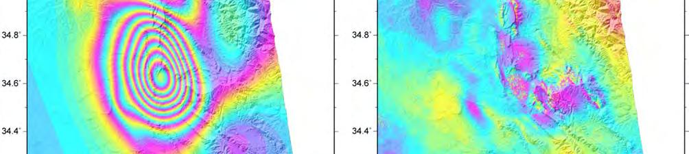
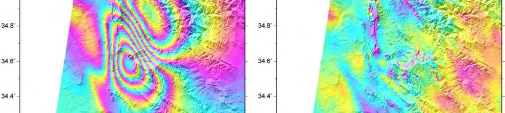
2 2. SAR Data Analysis A Japanese L-band synthetic aperture radar satellite, known as the Advanced Land Observing Satellite 2 (ALOS-2), made emergency observations for the purpose of detecting crustal deformation using InSAR. The images used in the study are listed in Table 1. We analyzed the ScanSAR-ScanSAR interferometry. The ScanSAR data we processed were produced by a full-aperture method in which range/azimuth compression was performed for the data whose gaps between neighboring bursts were filled with zeroes. The original interferograms were contaminated by a long-wavelength phase change noise of unknown causes, maybe due in part to the ionospheric effect. To pick out the crustal deformation only, we modeled the noises by estimating a phase curve with a second-order polynomial from far-field data, and subtracted the estimated phase curve from the original interferograms. Observation Date Flight Direction Beam Direction Incidence Angle Observation Mode Perpendicular Baseline Table 1 Analyzed ALOS-2 images. Aug. 09, 2016 Nov. 14, 2017 Ascending Right Oct. 04, 2017 Nov. 15, 2017 Descending Right ScanSAR- ScanSAR ScanSAR- ScanSAR 70 m +160 m Figure # Fig. 2 Fig. 3 We processed the ALOS-2 data with GSISAR software (Fujiwara and Tobita, 1999; Tobita et al., 1999; Fujiwara et al., 1999; Tobita, 2003), and used ASTER GDEM for the InSAR analyses. 3. Ground displacement detected by InSAR 3.1 Line-of-sight component Figs. 2a and 3a show interferograms obtained from ascending and descending orbit data, respectively. The coherence is high for the most part, probably due to the less-vegetated environment. An intensive deformation is located around 20 km NNW of Sarpol-e Zahab city. Two clear roundish fringes appear in both images. In Fig. 2a, slant range shortening signals are distributed in both lobes. The maximum line-of-sight (LOS) displacements are ~90 cm shortening for the southwestern lobe at most and ~15 cm shortening for the northeastern lobe at most. On the other hand, in Fig. 3a, slant range shortening and lengthening signals appear in the southwest and the northeast, respectively. The maximum LOS displacements are ~50 cm shortening for the southwestern lobe at most and ~35 cm lengthening for the northeastern lobe at most. 3.2 Quasi-up-down and quasi east-west components We have both descending and ascending data that are right-looking, in which the microwaves are emitted from two opposite directions from the eastern sky and the western sky. This enables the derived LOS displacements to be converted into two components which are the quasi-up-down (QUD) and quasi-east-west (QEW) components (Fig. 4) (Fujiwara et al., 2000). Figs 5a and 5b show the estimated QUD and QEW components, respectively. In Fig. 5a, the red and blue colors mean uplift and subsidence, respectively. We can identify a large uplift is distributed in the southwest of the epicenter with ~90 cm at most. In contrast, in and around the epicentral area, the ground has subsided with ~30 cm. In Fig. 5b, the red and green colors mean eastward and westward movements, respectively. There appear two main westward movement areas in the southwest with ~50 cm at most and in the northeast with ~35 cm at most. These spatial patterns are in agreement with crustal deformation produced by a reverse slip motion on a NW-SE striking fault plane. 3.3 Local Ground Displacement Here we stress that we can identify many localized LOS displacements in the InSAR images, apart from the fault-slip-related crustal deformation. Figs. 2b and 2c show enlarged views of Fig. 2a. Note that we filtered out the long-wavelength signals corresponding to the fault-related deformation to pick out localized displacements. We can identify small and local but clear phase changes in the high-pass filtered image. Also, applying the high-pass filter to the InSAR data of descending orbit in the same manner,


3 Fig. 2 An InSAR image for the ascending orbit. (a) An InSAR image covering the source region. (b) and (c) Enlarged views. A high-pass filter was applied to remove the long-wavelength signals. Fig. 3 Same as Fig. 2 but for the descending orbit data.
 A quasi-east-west component.")


4 Fig. 4 Geometry of 2.5D displacement analysis. Fig D displacement fields. (a) A quasi-up-down component. The red and blue colors mean uplift and subsidence, respectively. (b) A quasi-east-west component. The red and green colors mean eastward and westward movements, respectively. the localized phase changes can be identified at almost the same locations, but with the opposite sign, indicating that the horizontal (EW) displacement is dominant (Figs. 3b and 3c). Most of the localized displacements are detected at mountain slopes and are consistent with downward movement along the slopes. These displacements might have been triggered by the seismic motion. 3.4 Linear Surface Ruptures The InSAR images generally show elastic deformation caused by the main earthquakes, but many other linear discontinuities showing displacement are also found (Fujiwara et al., 2016). We mapped the ruptures in the two InSAR images in Fig. 6. Most of the ruptures are likely secondary faults that are not directly related to the main earthquake but whose slip was probably triggered by the main earthquake or
5 aftershocks. 4. Fault model We constructed a slip distribution model by a least squares approach (e.g., Kobayashi et al. 2015). In the inversion, we used both the ascending and the descending orbit data shown in Figs. 2a and 3a. The fault geometry was assumed to be a plane fault. We set a rectangular fault of 100 km long and 80 km wide, and the fault was divided into square patches of 5 5 km in size. The fault geometry basically followed the USGS s Centroid Moment Tensor (CMT) solution (USGS, 2017). According to previous geological and seismological studies, a low-angle thrust system with a NE-dipping plane may have developed in this region (e.g., Vergés et al., 2011; Madanipour et al. 2013). Thus we followed this idea; that is, we took a nodal plane dipping to NE with a dip angle of 16. The strike was fixed so as to be almost parallel to the plate boundary (Bird, 2003). We adjusted the fault depth so that the USGS's hypocenter (19 km in depth) could be on the fault plane. Consequently, the fault top position was fixed to a depth of 3 km below the surface. We used the dislocation equations proposed by Okada (1985) to calculate the surface displacement in the LOS directions. Only the dip-slip and strike-slip components were estimated for each patch. A large number of model parameters often give rise to instability of the solution. To stabilize the solution, we imposed a spatial smoothness constraint on the slip distribution using a Laplacian operator. The relative weight of the constraints was determined by Akaike s Baysian information criterion (Akaike, 1980). Here, we assumed a rigidity of 30 GPa. The data points of the interferograms were too many to be easily assimilated in a modeling scheme. In order to reduce the number of data for the modeling analysis, we resampled the interferogram data beforehand, using a quadtree decomposition method. Essentially, we followed an algorithm presented by Jónsson et al. (2002). For a given quadrant, after removing the mean, if the residue was greater than a prescribed threshold (5 cm in our case), the quadrant was further divided into four new quadrants. This process was iterated either until each block met the specified criterion or until the quadrant reached a minimum block size (8 8 pixels in our case). Upon application of this procedure, the sizes of the respective interferogram data sets were reduced from 1,443,200 to 239 for the ascending data and to 279 for the descending data. Fig. 7 shows the estimated slip distribution, and Figs. 8 and 9 show the LOS displacements calculated from the derived model and the residuals, respectively. Our model reproduces well the LOS displacement fields for both the ascending and descending data. Fig. 10 shows the model-predicted UD, EW, and NS displacement components. Both UD and EW displacement fields are reproduced well. A major slip with a maximum slip amount of approximately 3 m occurred beneath the southeastern part of the epicenter. The slips were a nearly pure reverse fault motion, but with a slight right-lateral motion. The obtained oblique slip was consistent with the tectonic background that the Arabian plates obliquely subside against the Eurasian plate (Fig. 1). The moment is estimated to be Nm, equivalent to M w This is consistent with the seismic moment determined with seismic data (USGS CMT: Nm (M w 7.3); Global CMT Catalog (2017): Nm (M w 7.4)). 5. Concluding remarks We conducted InSAR analysis using ALOS-2 data to detect the crustal deformation associated with the 2017 Iran-Iraq earthquake. The following conclusions were obtained from the analyses: 1. Large displacement (~90 cm upward and ~50 cm westward) was detected around 20 km NNW of Sarpol-e Zahab. 2. Around the epicenter, ~30 cm downward and ~35 cm westward displacement was detected. 3. Apart from the deformation associated with the fault slip, lots of localized displacements were detected at mountain slopes, and might have been triggered by the seismic motion. 4. Our fault model shows a nearly pure reverse-fault with a slight dextral slip motion. A major slip occurred with a slip amount of ~3 m beneath the southwestern part of the epicenter. 5. The estimated moment magnitude was 7.31 (seismic moment Nm).
 and the descending orbit (b).")


6 Fig. 6 InSAR images for the ascending orbit (a) and the descending orbit (b). The solid lines show the identified linear surface ruptures. Fig. 7 (a) Slip distribution model. The arrows show slip vectors of the hanging wall. The contour interval is 1 m. The red star represents the hypocenter projected on the fault plane. (b) Slip distribution on map. (c) Schematic view of the source mechanism.
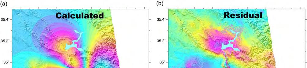
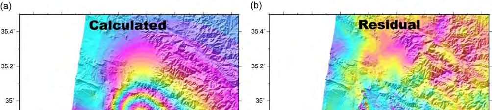
7 Fig. 8 (a) Model-calculated LOS displacement for the ascending orbit data. (b) Residual. Fig. 9 (a) Same as Fig. 7 but for the descending orbit data.
.")
 and the Ministry of Economy, Trade and Industry (METI).")
8 Fig. 10 Model-predicted displacements. (a) Up-Down component. (b) East-West component. (c) North-South component. Acknowledgments ALOS-2 data were provided by the Earthquake Working Group under a cooperative research contract with the Japan Aerospace Exploration Agency (JAXA). The ownership of ALOS-2 data belong to JAXA. We used Generic Mapping Tools (GMT) provided by Wessel and Smith (1998) to construct the figures for the fault model. We used ASTER GDEM for the InSAR analyses. ASTER GDEM is a product of the National Aeronautics and Space Administration (NASA) and the Ministry of Economy, Trade and Industry (METI). References Akaike, H (1980): Likelihood and the Bayes procedure. In: Bernardo. JM, DeGroot. MH, Lindley. DV, Smith.AFM, (eds) Bayesian Statistics. University Press, Valencia. Bird, P. (2003): An updated digital model of plate boundaries, Geochemistry Geophysics Geosystems, 4(3), Fujiwara, S and M. Tobita (1999): SAR interferometry techniques for precise surface change detection, J. Geod. Soc. Japan, 45, (in Japanese with English abstract). Fujiwara, S., M. Tobita, M. Murakami, H. Nakagawa and P. A. Rosen (1999): Baseline determination and correction of atmospheric delay induced by topography of SAR interferometry for precise surface change detection, J. Geod. Soc. Japan, 45, (in Japanese with English abstract). Fujiwara, S., T. Nishimura, M. Murakami, H. Nakagawa, M. Tobita and P. A. Rosen (2000): 2.5-D surface deformation of a M6.1 earthquake near Mt Iwate detected by SAR interferometry, Geophys. Res. Lett., 27, Fujiwara, S., H. Yarai, T. Kobayashi, Y. Morishita, T. Nakano, B. Miyahara, H. Nakai, Y. Miura, H. Ueshiba, Y. Kakiage and H. Une (2016): Small-displacement linear surface ruptures of the 2016 Kumamoto earthquake sequence detected by ALOS-2 SAR interferometry, Earth Planets Space, 68: 160. Global Centroid Moment Tensor Catalog (2017): A IRAN-IRAQ BORDER REGION, (accessed Dec.7, 2017). Jónsson, S., H. Zebker, P. Segall and F. Amelung (2002) : Fault slip distribution of the 1999 Mw 7.1 Hector Mine, California, earthquake, estimated from satellite radar and GPS measurements, Bull. Seism. Soc. Amer., 92, Kobayashi, T., Y. Morishita and H. Yarai (2015): Detailed crustal deformation and fault rupture of the 2015 Gorkha earthquake, Nepal, revealed from ScanSAR-based interferograms of ALOS-2, Earth Planets Space, 67:201. Madanipour, S., Ehlers, T., Yassaghi, A., Rezaeian, M., Enkelmann E and Bahroudi, A (2013): Synchronous deformation on orogenic plateau margins: Insights from the Arabia Eurasia collision, Tectonophysics, 608, (accessed Dec.7, 2017). Okada, Y (1985): Surface deformation due to shear and tensile faults in a halfspace, Bull Seismol Soc Am, 75,
9 Tobita, M., S. Fujiwara, M. Murakami, H. Nakagawa and P. A. Rosen (1999): Accurate offset estimation between two SLC images for SAR interferometry, J. Geod. Soc. Japan, 45, (in Japanese with English abstract). Tobita, M (2003): Development of SAR interferometry analysis and its application to crustal deformation study, J. Geod. Soc. Japan, 49, 1-23 (in Japanese with English abstract). U. S. Geological Survey (2017): M7.3 30km S of Halabjar, Iraq bmcg#executive (accessed Dec.7, 2017). Vergés, J., Saura, E., Casciello, E., Fernàndez, M., Villaseñor, A., Jiménez-Munt, I., García-Castellanos, D (2011): Crustal-scale cross-sections across the NW Zagros belt: implications for the Arabian margin reconstruction, Geological Magazine, 148, Vernant, Ph., F. Nilforoushan, D. Hatzfeld, M.R. Abbassi, C. Vigny, F. Masson, H. Nankali, J. Martinod, M. Ghafory-Ashtiany, R. Bayer, F. Tavakoli and J. Chéry (2004) : Present-Day Crustal Deformation and Plate Kinematics in the Middle East Constrained by GPS Measurements in Iran and Northern Oman, Geophys. J., Int., 157, Wessel, P and Smith, WH (1998): New, improved version of Generic Mapping Tools released, Eos Trans AGU, 79, 579.
DETECTION OF CRUSTAL DEFORMATION OF THE NORTHERN PAKISTAN EARTHQUAKE BY SATELLITE DATA. Submitted by Japan **
 UNITED NATIONS E/CONF.97/5/CRP. 5 ECONOMIC AND SOCIAL COUNCIL Seventeenth United Nations Regional Cartographic Conference for Asia and the Pacific Bangkok, 18-22 September 2006 Item 6 (b) of the provisional
INGV. Giuseppe Pezzo. Istituto Nazionale di Geofisica e Vulcanologia, CNT, Roma. Sessione 1.1: Terremoti e le loro faglie
 Giuseppe Pezzo Istituto Nazionale di Geofisica e Vulcanologia, CNT, Roma giuseppe.pezzo@ingv.it The study of surface deformation is one of the most important topics to improve the knowledge of the deep
Field Survey of Non-tectonic Surface Displacements Caused by the 2016 Kumamoto Earthquake Around Aso Valley
 Field Survey of Non-tectonic Surface Displacements Caused by the 2016 Kumamoto Earthquake Around Aso Valley 47 Field Survey of Non-tectonic Surface Displacements Caused by the 2016 Kumamoto Earthquake
The March 11, 2011, Tohoku-oki earthquake (Japan): surface displacement and source modelling
: surface displacement and source modelling") The March 11, 2011, Tohoku-oki earthquake (Japan): surface displacement and source modelling Salvatore Stramondo Bignami C., Borgstrom S., Chini M., Guglielmino F., Melini D., Puglisi G., Siniscalchi V.,
The March 11, 2011, Tohoku-oki earthquake (Japan): surface displacement and source modelling Salvatore Stramondo Bignami C., Borgstrom S., Chini M., Guglielmino F., Melini D., Puglisi G., Siniscalchi V.,
22 Bulletin of the Geospatial Information Authority of Japan, Vol.59 December, 2011 Fig. 1 Crustal deformation (horizontal) associated with the 2011 o
 associated with the 2011 o") The Crustal Deformation and Fault Model of the 2011 off the Pacific Coast of Tohoku Earthquake 21 The Crustal Deformation and Fault Model of the 2011 off the Pacific Coast of Tohoku Earthquake Tetsuro
The Crustal Deformation and Fault Model of the 2011 off the Pacific Coast of Tohoku Earthquake 21 The Crustal Deformation and Fault Model of the 2011 off the Pacific Coast of Tohoku Earthquake Tetsuro
Fault model of the 2007 Noto Hanto earthquake estimated from PALSAR radar interferometry and GPS data
 LETTER Earth Planets Space, 60, 99 104, 2008 Fault model of the 2007 Noto Hanto earthquake estimated from PALSAR radar interferometry and GPS data Yo Fukushima 1, Taku Ozawa 2, and Manabu Hashimoto 1 1
Magnitude 7.3 IRAQ. Early reports indicate that 140 have been killed with over 800 injuries reported. Sunday, November 12, 2017 at 18:18:17 UTC
 A magnitude 7.3 earthquake has occurred in the northern border region of Iran and Iraq centered about 350 kilometers (217 miles) north of Baghdad at a depth of 33.9 km (21 miles). The earthquake was felt
to: Interseismic strain accumulation and the earthquake potential on the southern San
 Supplementary material to: Interseismic strain accumulation and the earthquake potential on the southern San Andreas fault system by Yuri Fialko Methods The San Bernardino-Coachella Valley segment of the
27th Seismic Research Review: Ground-Based Nuclear Explosion Monitoring Technologies
 GROUND TRUTH OF AFRICAN AND EASTERN MEDITERRANEAN SHALLOW SEISMICITY USING SAR INTERFEROMETRY AND GIBBS SAMPLING INVERSION Benjamin A. Brooks 1, Francisco Gomez 2, Eric A. Sandvol 2, and Neil Frazer 1
27th Seismic Research Review: Ground-Based Nuclear Explosion Monitoring Technologies
 GROUND TRUTH LOCATIONS USING SYNERGY BETWEEN REMOTE SENSING AND SEISMIC METHODS-APPLICATION TO CHINESE AND NORTH AFRICAN EARTHQUAKES C. K. Saikia 1, H. K. Thio 2, D. V. Helmberger 2, G. Ichinose 1, and
RELOCATION OF THE MACHAZE AND LACERDA EARTHQUAKES IN MOZAMBIQUE AND THE RUPTURE PROCESS OF THE 2006 Mw7.0 MACHAZE EARTHQUAKE
 RELOCATION OF THE MACHAZE AND LACERDA EARTHQUAKES IN MOZAMBIQUE AND THE RUPTURE PROCESS OF THE 2006 Mw7.0 MACHAZE EARTHQUAKE Paulino C. FEITIO* Supervisors: Nobuo HURUKAWA** MEE07165 Toshiaki YOKOI** ABSTRACT
Episodic growth of fault-related fold in northern Japan observed by SAR interferometry
 GEOPHYSICAL RESEARCH LETTERS, VOL. 35,, doi:10.1029/2008gl034337, 2008 Episodic growth of fault-related fold in northern Japan observed by SAR interferometry Takuya Nishimura, 1 Mikio Tobita, 1 Hiroshi
NOTES AND CORRESPONDENCE Segmented Faulting Process of Chelungpu Thrust: Implication of SAR Interferograms
 , Vol. 14, No.2, 241-247, June 2003 NOTES AND CORRESPONDENCE Segmented Faulting Process of Chelungpu Thrust: Implication of SAR Interferograms Chien-Chih Chen 1,*, Chung-Pai Chang 2, and Kun-Shan Chen
Chapter 2. Earthquake and Damage
 EDM Report on the Chi-Chi, Taiwan Earthquake of September 21, 1999 2.1 Earthquake Fault 2.1.1 Tectonic Background The island of Taiwan is located in the complex junction where the Eurasian and Philippine
3D temporal evolution of displacements recorded on Mt. Etna from the 2007 to 2010 through the SISTEM method
 3D temporal evolution of displacements recorded on Mt. Etna from the 2007 to 2010 through the SISTEM method Bonforte A., Guglielmino F.,, Puglisi G. INGV Istituto Nazionale di Gofisica e vulcanologia Osservatorio
Geometry of co-seismic surface ruptures and tectonic meaning of the 23 October 2011 Mw 7.1 Van earthquake (East Anatolian Region, Turkey)
") Geometry of co-seismic surface ruptures and tectonic meaning of the 23 October 2011 Mw 7.1 Van earthquake (East Anatolian Region, Turkey) Bülent Dogan & Ahmet Karakaș. Journal of Structural Geology, 46(2013),
Geometry of co-seismic surface ruptures and tectonic meaning of the 23 October 2011 Mw 7.1 Van earthquake (East Anatolian Region, Turkey) Bülent Dogan & Ahmet Karakaș. Journal of Structural Geology, 46(2013),
Locations and types of ruptures involved in the 2008 Sichuan earthquake inferred from SAR image matching
 GEOPHYSICAL RESEARCH LETTERS, VOL. 36, L07302, doi:10.1029/2008gl036907, 2009 Locations and types of ruptures involved in the 2008 Sichuan earthquake inferred from SAR image matching Tomokazu Kobayashi,
Open Access FULL PAPER. Yukitoshi Fukahata * and Manabu Hashimoto
 DOI 1.116/s63--5- FULL PAPER Open Access Simultaneous estimation of the dip angles and slip distribution on the faults of the Kumamoto earthquake through a weak nonlinear inversion of InSAR data Yukitoshi
Line of Sight Displacement from ALOS-2 Interferometry: Mw 7.8 Gorkha Earthquake and Mw 7.3 Aftershock
 Line of Sight Displacement from ALOS-2 Interferometry: Mw 7.8 Gorkha Earthquake and Mw 7.3 Aftershock Eric O. Lindsey 1 Ryo Natsuaki 2 Xiaohua Xu 1 Masanobu Shimada 2 Manabu, Hashimoto 3 Diego Melgar 4
Coulomb stress changes due to Queensland earthquakes and the implications for seismic risk assessment
 Coulomb stress changes due to Queensland earthquakes and the implications for seismic risk assessment Abstract D. Weatherley University of Queensland Coulomb stress change analysis has been applied in
Basics of the modelling of the ground deformations produced by an earthquake. EO Summer School 2014 Frascati August 13 Pierre Briole
 Basics of the modelling of the ground deformations produced by an earthquake EO Summer School 2014 Frascati August 13 Pierre Briole Content Earthquakes and faults Examples of SAR interferograms of earthquakes
INVESTIGATION OF EARTHQUAKE-CYCLE DEFORMATION IN TIBET FROM ALOS PALSAR DATA PI 168 Roland Bürgmann 1, Mong-Han Huang 1, Isabelle Ryder 2, and Eric Fi
 INVESTIGATION OF EARTHQUAKE-CYCLE DEFORMATION IN TIBET FROM ALOS PALSAR DATA PI 168 Roland Bürgmann 1, Mong-Han Huang 1, Isabelle Ryder 2, and Eric Fielding 3 1 Berkeley Seismological Laboratory, University
Widespread Ground Motion Distribution Caused by Rupture Directivity during the 2015 Gorkha, Nepal Earthquake
 Widespread Ground Motion Distribution Caused by Rupture Directivity during the 2015 Gorkha, Nepal Earthquake Kazuki Koketsu 1, Hiroe Miyake 2, Srinagesh Davuluri 3 and Soma Nath Sapkota 4 1. Corresponding
Case study of Japan: Reference Frames in Practice
 Case study of Japan: Reference Frames in Practice Basara Miyahara and Koji Matsuo Sponsors: 1 Outline Introduction - Geodetic reference frame of Japan - GEONET : continuous GNSS observation system Geometric
Earthquakes and Seismotectonics Chapter 5
 Earthquakes and Seismotectonics Chapter 5 What Creates Earthquakes? The term Earthquake is ambiguous: Applies to general shaking of the ground and to the source of the shaking We will talk about both,
Slow Deformation of Mt. Baekdu Stratovolcano Observed by Satellite Radar Interferometry
 Slow Deformation of Mt. Baekdu Stratovolcano Observed by Satellite Radar Interferometry Sang-Wan Kim and Joong-Sun Won Department of Earth System Sciences, Yonsei University 134 Shinchon-dong, Seodaemun-gu,
Haiti Earthquake (12-Jan-2010) co-seismic motion using ALOS PALSAR
 co-seismic motion using ALOS PALSAR") Haiti Earthquake (12-Jan-2010) co-seismic motion using ALOS PALSAR Urs Wegmüller, Charles Werner, Maurizio Santoro Gamma Remote Sensing, CH-3073 Gümligen, Switzerland SAR data: JAXA, METI; PALSAR AO Project
Haiti Earthquake (12-Jan-2010) co-seismic motion using ALOS PALSAR Urs Wegmüller, Charles Werner, Maurizio Santoro Gamma Remote Sensing, CH-3073 Gümligen, Switzerland SAR data: JAXA, METI; PALSAR AO Project
Magnitude 7.1 NEAR THE EAST COAST OF HONSHU, JAPAN
 Japan was rattled by a strong aftershock and tsunami warning Thursday night nearly a month after a devastating earthquake and tsunami flattened the northeastern coast. This earthquake can be considered
Ground displacement in a fault zone in the presence of asperities
 BOLLETTINO DI GEOFISICA TEORICA ED APPLICATA VOL. 40, N. 2, pp. 95-110; JUNE 2000 Ground displacement in a fault zone in the presence of asperities S. SANTINI (1),A.PIOMBO (2) and M. DRAGONI (2) (1) Istituto
Source rupture process of the 2003 Tokachi-oki earthquake determined by joint inversion of teleseismic body wave and strong ground motion data
 LETTER Earth Planets Space, 56, 311 316, 2004 Source rupture process of the 2003 Tokachi-oki earthquake determined by joint inversion of teleseismic body wave and strong ground motion data Yuji Yagi International
ON NEAR-FIELD GROUND MOTIONS OF NORMAL AND REVERSE FAULTS FROM VIEWPOINT OF DYNAMIC RUPTURE MODEL
 1 Best Practices in Physics-based Fault Rupture Models for Seismic Hazard Assessment of Nuclear ON NEAR-FIELD GROUND MOTIONS OF NORMAL AND REVERSE FAULTS FROM VIEWPOINT OF DYNAMIC RUPTURE MODEL Hideo AOCHI
Sendai Earthquake NE Japan March 11, Some explanatory slides Bob Stern, Dave Scholl, others updated March
 Sendai Earthquake NE Japan March 11, 2011 Some explanatory slides Bob Stern, Dave Scholl, others updated March 14 2011 Earth has 11 large plates and many more smaller ones. Plates are 100-200 km thick
EARTHQUAKE SOURCE PARAMETERS FOR SUBDUCTION ZONE EVENTS CAUSING TSUNAMIS IN AND AROUND THE PHILIPPINES
 EARTHQUAKE SOURCE PARAMETERS FOR SUBDUCTION ZONE EVENTS CAUSING TSUNAMIS IN AND AROUND THE PHILIPPINES Joan Cruz SALCEDO Supervisor: Tatsuhiko HARA MEE09186 ABSTRACT We have made a set of earthquake source
Earthquakes in Barcelonnette!
 Barcelonnette in the Ubaye valley : the landscape results of large deformations during the alpine orogene (40 5 Myr in this area) and the succession of Quaternary glaciations. The sedimentary rocks are
Displacement field and slip distribution of the 2005 Kashmir earthquake from SAR imagery
 Click Here for Full Article GEOPHYSICAL RESEARCH LETTERS, VOL. 33,, doi:10.1029/2006gl027193, 2006 Displacement field and slip distribution of the 2005 Kashmir earthquake from SAR imagery E. Pathier, 1
Case Study of Japan: Crustal deformation monitoring with GNSS and InSAR
 Technical Seminar Reference Frame in Practice, Case Study of Japan: Crustal deformation monitoring with GNSS and InSAR Basara Miyahara miyahara-b96ip@milt.go.jp Geospatial Information Authority of Japan
FOCAL MECHANISM DETERMINATION USING WAVEFORM DATA FROM A BROADBAND STATION IN THE PHILIPPINES
 FOCAL MECHANISM DETERMINATION USING WAVEFORM DATA FROM A BROADBAND STATION IN THE PHILIPPINES Vilma Castillejos Hernandez Supervisor: Tatsuhiko Hara MEE10508 ABSTRACT We performed time domain moment tensor
Fault Specific, Dynamic Rupture Scenarios for Strong Ground Motion Prediction
 Fault Specific, Dynamic Rupture Scenarios for Strong Ground Motion Prediction H. Sekiguchi Disaster Prevention Research Institute, Kyoto University, Japan Blank Line 9 pt Y. Kase Active Fault and Earthquake
Seismic Activity near the Sunda and Andaman Trenches in the Sumatra Subduction Zone
 IJMS 2017 vol. 4 (2): 49-54 International Journal of Multidisciplinary Studies (IJMS) Volume 4, Issue 2, 2017 DOI: http://doi.org/10.4038/ijms.v4i2.22 Seismic Activity near the Sunda and Andaman Trenches
Coulomb stress change for the normal-fault aftershocks triggered near the Japan Trench by the 2011 M w 9.0 Tohoku-Oki earthquake
 Earth Planets Space, 64, 1239 1243, 2012 Coulomb stress change for the normal-fault aftershocks triggered near the Japan Trench by the 2011 M w 9.0 Tohoku-Oki earthquake Tamao Sato 1, Shinya Hiratsuka
Multi-planar structures in the aftershock distribution of the Mid Niigata prefecture Earthquake in 2004
 LETTER Earth Planets Space, 57, 411 416, 2005 Multi-planar structures in the aftershock distribution of the Mid Niigata prefecture Earthquake in 2004 Shigeki Aoki 1, Masaki Nishi 2, Koji Nakamura 2, Tetsuo
Ground surface deformation of L Aquila. earthquake revealed by InSAR time series
 Ground surface deformation of L Aquila earthquake revealed by InSAR time series Reporter: Xiangang Meng Institution: First Crust Monitoring and Application Center, CEA Address: 7 Naihuo Road, Hedong District
Measuring Earthquake-Induced Deformation in the South of Halabjah (Sarpol-e-Zahab) Using Sentinel-1 Data on November 12, 2017
 Using Sentinel-1 Data on November 12, 2017") Proceedings Measuring Earthquake-Induced Deformation in the South of Halabjah (Sarpol-e-Zahab) Using Sentinel-1 Data on November 12, 2017 Hamit Beran GUNCE 1 and Bekir Taner SAN 2, * 1 Department of Geological
Proceedings Measuring Earthquake-Induced Deformation in the South of Halabjah (Sarpol-e-Zahab) Using Sentinel-1 Data on November 12, 2017 Hamit Beran GUNCE 1 and Bekir Taner SAN 2, * 1 Department of Geological
FOCAL MECHANISM DETERMINATION OF LOCAL EARTHQUAKES IN MALAY PENINSULA
 FOCAL MECHANISM DETERMINATION OF LOCAL EARTHQUAKES IN MALAY PENINSULA Siti Norbaizura MAT SAID Supervisor: Tatsuhiko HARA MEE10505 ABSTRACT Since November 30, 2007, small local earthquakes have been observed
Study on the feature of surface rupture zone of the west of Kunlunshan pass earthquake ( M S 811) with high spatial resolution satellite images
 with high spatial resolution satellite images") 48 2 2005 3 CHINESE JOURNAL OF GEOPHYSICS Vol. 48, No. 2 Mar., 2005,,. M S 811.,2005,48 (2) :321 326 Shan X J, Li J H, Ma C. Study on the feature of surface rupture zone of the West of Kunlunshan Pass
48 2 2005 3 CHINESE JOURNAL OF GEOPHYSICS Vol. 48, No. 2 Mar., 2005,,. M S 811.,2005,48 (2) :321 326 Shan X J, Li J H, Ma C. Study on the feature of surface rupture zone of the West of Kunlunshan Pass
Journal of Geophysical Research - Solid Earth
 Journal of Geophysical Research - Solid Earth Supporting Information for Transpressional Rupture Cascade of the 2016 M w 7.8 Kaikoura Earthquake, New Zealand Wenbin Xu 1*, Guangcai Feng 2*, Lingsen Meng
Regional Geodesy. Shimon Wdowinski. MARGINS-RCL Workshop Lithospheric Rupture in the Gulf of California Salton Trough Region. University of Miami
 MARGINS-RCL Workshop Lithospheric Rupture in the Gulf of California Salton Trough Region Regional Geodesy Shimon Wdowinski University of Miami Rowena Lohman, Kim Outerbridge, Tom Rockwell, and Gina Schmalze
SOURCE PROCESS OF THE 2003 PUERTO PLATA EARTHQUAKE USING TELESEISMIC DATA AND STRONG GROUND MOTION SIMULATION
 Synopses of Master Papers Bulletin of IISEE, 47, 19-24, 2013 SOURCE PROCESS OF THE 2003 PUERTO PLATA EARTHQUAKE USING TELESEISMIC DATA AND STRONG GROUND MOTION SIMULATION Fabricio Moquete Everth* Supervisor:
COULOMB STRESS CHANGES DUE TO RECENT ACEH EARTHQUAKES
 COULOMB STRESS CHANGES DUE TO RECENT ACEH EARTHQUAKES Madlazim Physics Department, Faculty Mathematics and Sciences of Surabaya State University (UNESA) Jl. Ketintang, Surabaya 60231, Indonesia. e-mail:
ESTIMATES OF HORIZONTAL DISPLACEMENTS ASSOCIATED WITH THE 1999 TAIWAN EARTHQUAKE
 ESTIMATES OF HORIZONTAL DISPLACEMENTS ASSOCIATED WITH THE 1999 TAIWAN EARTHQUAKE C. C. Chang Department of Surveying and Mapping Engineering Chung Cheng Institute of Technology, Taiwan, ROC ABSTRACT A
Buried Strike Slip Faults: The 1994 and 2004 Al Hoceima, Morocco Earthquakes.
 Buried Strike Slip Faults: The 1994 and 2004 Al Hoceima, Morocco Earthquakes. Juliet Biggs 1, Eric Bergman 2, Brian Emmerson 3, Gareth Funning 4, James Jackson 3, Barry Parsons 1,Tim Wright 1. 1 COMET,
Co-seismic slip from the July 30, 1995, M w 8.1 Antofagasta, Chile, earthquake as constrained by InSAR and GPS observations
 98 Chapter 3 Co-seismic slip from the July 30, 1995, M w 8.1 Antofagasta, Chile, earthquake as constrained by InSAR and GPS observations Published by Blackwell Publishing Ltd. in Geophysical Journal International
Journal of Geophysical Research Letters Supporting Information for
 Journal of Geophysical Research Letters Supporting Information for InSAR observations of strain accumulation and fault creep along the Chaman Fault system, Pakistan and Afghanistan H. Fattahi 1, F. Amelung
RELOCATION OF LARGE EARTHQUAKES ALONG THE PHILIPPINE FAULT ZONE AND THEIR FAULT PLANES
 RELOCATION OF LARGE EARTHQUAKES ALONG THE PHILIPPINE FAULT ZONE AND THEIR FAULT PLANES Rey M. Lumbang MEE12608 Supervisor: Nobuo Hurukawa ABSTRACT We relocated large magnitude (Mw 7.0) earthquakes that
Separating Tectonic, Magmatic, Hydrological, and Landslide Signals in GPS Measurements near Lake Tahoe, Nevada-California
 Separating Tectonic, Magmatic, Hydrological, and Landslide Signals in GPS Measurements near Lake Tahoe, Nevada-California Geoffrey Blewitt, Corné Kreemer, William C. Hammond, & Hans-Peter Plag NV Geodetic
Crustal deformation by the Southeast-off Kii Peninsula Earthquake
 Crustal deformation by the Southeast-off Kii Peninsula Earthquake 51 Crustal deformation by the Southeast-off Kii Peninsula Earthquake Tetsuro IMAKIIRE, Shinzaburo OZAWA, Hiroshi YARAI, Takuya NISHIMURA
Slip distributions of the 1944 Tonankai and 1946 Nankai earthquakes including the horizontal movement effect on tsunami generation
 Slip distributions of the 1944 Tonankai and 1946 Nankai earthquakes including the horizontal movement effect on tsunami generation Toshitaka Baba Research Program for Plate Dynamics, Institute for Frontier
Burst overlapping of ALOS-2 PALSAR-2 ScanSAR-ScanSAR interferometry
 Burst overlapping of ALOS-2 PALSAR-2 ScanSAR-ScanSAR interferometry Japan Aerospace Exploration Agency Earth Observation Research Center Ryo Natsuaki, Takeshi Motohka, Shinichi Suzuki and Masanobu Shimada
Development of a Predictive Simulation System for Crustal Activities in and around Japan - II
 Development of a Predictive Simulation System for Crustal Activities in and around Japan - II Project Representative Mitsuhiro Matsu'ura Graduate School of Science, The University of Tokyo Authors Mitsuhiro
Synthetic Seismicity Models of Multiple Interacting Faults
 Synthetic Seismicity Models of Multiple Interacting Faults Russell Robinson and Rafael Benites Institute of Geological & Nuclear Sciences, Box 30368, Lower Hutt, New Zealand (email: r.robinson@gns.cri.nz).
revised October 30, 2001 Carlos Mendoza
 Earthquake Sources in the circum-caribbean Region Puerto Rico Tsunami Mitigation and Warning Program Federal Emergency Management Agency Preliminary Report: Task 3 revised October 30, 2001 Carlos Mendoza
Magnitude 7.0 PAPUA, INDONESIA
 A 7.0 magnitude earthquake struck eastern Indonesia's mountainous West Papua province on Saturday but there were no immediate reports of casualties or damage. The region is sparsely populated. According
Earth Science, (Tarbuck/Lutgens) Chapter 10: Mountain Building
 Chapter 10: Mountain Building") Earth Science, (Tarbuck/Lutgens) Chapter 10: Mountain Building 1) A(n) fault has little or no vertical movements of the two blocks. A) stick slip B) oblique slip C) strike slip D) dip slip 2) In a(n) fault,
Earth Science, (Tarbuck/Lutgens) Chapter 10: Mountain Building 1) A(n) fault has little or no vertical movements of the two blocks. A) stick slip B) oblique slip C) strike slip D) dip slip 2) In a(n) fault,
Fault Length and Direction of Rupture Propagation for the 1993 Kushiro-Oki Earthquake as Derived from Strong Motion Duration
 Letter J. Phys. Earth, 41, 319-325, 1993 Fault Length and Direction of Rupture Propagation for the 1993 Kushiro-Oki Earthquake as Derived from Strong Motion Duration Yasuo Izutani Faculty of Engineering,
Conference Proceedings Paper Measuring Earthquake Induced Deformation in South of Halabjah (Sarpol-e-Zahab) Using Sentinel1 Data on November 12, 2017
 Using Sentinel1 Data on November 12, 2017") 1 2 3 4 5 6 7 8 9 10 11 12 13 14 15 16 17 18 19 20 21 22 23 24 25 26 27 28 29 30 31 32 33 34 35 36 37 38 39 40 Conference Proceedings Paper Measuring Earthquake Induced Deformation in South of Halabjah
1 2 3 4 5 6 7 8 9 10 11 12 13 14 15 16 17 18 19 20 21 22 23 24 25 26 27 28 29 30 31 32 33 34 35 36 37 38 39 40 Conference Proceedings Paper Measuring Earthquake Induced Deformation in South of Halabjah
Numerical simulation of seismic cycles at a subduction zone with a laboratory-derived friction law
 Numerical simulation of seismic cycles at a subduction zone with a laboratory-derived friction law Naoyuki Kato (1), Kazuro Hirahara (2) and Mikio Iizuka (3) (1) Earthquake Research Institute, University
RELOCATION OF LARGE EARTHQUAKES ALONG THE SUMATRAN FAULT AND THEIR FAULT PLANES
 Synopses of Master Papers Bulletin of IISEE, 47, 25-30, 2013 RELOCATION OF LARGE EARTHQUAKES ALONG THE SUMATRAN FAULT AND THEIR FAULT PLANES Biana Rahayu Wulandari MEE11605 Supervisor: Nobuo HURUKAWA ABSTRACT
2008 Monitoring Research Review: Ground-Based Nuclear Explosion Monitoring Technologies
 STRUCTURE OF THE KOREAN PENINSULA FROM WAVEFORM TRAVEL-TIME ANALYSIS Roland Gritto 1, Jacob E. Siegel 1, and Winston W. Chan 2 Array Information Technology 1 and Harris Corporation 2 Sponsored by Air Force
Monitoring long-term ground movements and Deep Seated Gravitational
 Monitoring long-term ground movements and Deep Seated Gravitational Slope Deformations by InSAR time series: cases studies in Italy Salvatore Stramondo (1), M. Saroli (1, 2), M. Moro (1, 2), S. Atzori
Geodesy (InSAR, GPS, Gravity) and Big Earthquakes
 and Big Earthquakes") Geodesy (InSAR, GPS, Gravity) and Big Earthquakes Mathew Pritchard Teh-Ru A. Song Yuri Fialko Luis Rivera Mark Simons UJNR Earthquake Research Panel, Morioka, Japan - Nov 6, 2002 Goals Accurate and high
Geodesy (InSAR, GPS, Gravity) and Big Earthquakes Mathew Pritchard Teh-Ru A. Song Yuri Fialko Luis Rivera Mark Simons UJNR Earthquake Research Panel, Morioka, Japan - Nov 6, 2002 Goals Accurate and high
The Mw 6.2 Leonidio, southern Greece earthquake of January 6, 2008: Preliminary identification of the fault plane.
 The Mw 6.2 Leonidio, southern Greece earthquake of January 6, 28: Preliminary identification of the fault plane. J. Zahradnik 1, E. Sokos 2, A.Serpetsidaki 2, and G A.Tselentis 2 1 Charles University in
EARTHQUAKE LOCATIONS INDICATE PLATE BOUNDARIES EARTHQUAKE MECHANISMS SHOW MOTION
 6-1 6: EARTHQUAKE FOCAL MECHANISMS AND PLATE MOTIONS Hebgen Lake, Montana 1959 Ms 7.5 1 Stein & Wysession, 2003 Owens Valley, California 1872 Mw ~7.5 EARTHQUAKE LOCATIONS INDICATE PLATE BOUNDARIES EARTHQUAKE
SUPPLEMENTARY INFORMATION
 SUPPLEMENTARY INFORMATION doi: 10.1038/ngeo739 Supplementary Information to variability and distributed deformation in the Marmara Sea fault system Tobias Hergert 1 and Oliver Heidbach 1,* 1 Geophysical
Bonn, Germany MOUTAZ DALATI. General Organization for Remote Sensing ( GORS ), Syria Advisor to the General Director of GORS,
, Syria Advisor to the General Director of GORS,") Bonn, Germany Early Warning System is needed for Earthquakes disaster mitigation in Syria Case Study: Detecting and Monitoring the Active faulting zones along the Afro-Arabian-Syrian Rift System MOUTAZ
Bonn, Germany Early Warning System is needed for Earthquakes disaster mitigation in Syria Case Study: Detecting and Monitoring the Active faulting zones along the Afro-Arabian-Syrian Rift System MOUTAZ
High-resolution temporal imaging of. Howard Zebker
 High-resolution temporal imaging of crustal deformation using InSAR Howard Zebker Stanford University InSAR Prehistory SEASAT Topographic Fringes SEASAT Deformation ERS Earthquake Image Accurate imaging
Coseismic surface-ruptures and crustal deformations of the 2008 Wenchuan earthquake Mw7.9, China
 GEOPHYSICAL RESEARCH LETTERS, VOL. 36, L11303, doi:10.1029/2009gl037971, 2009 Coseismic surface-ruptures and crustal deformations of the 2008 Wenchuan earthquake Mw7.9, China Ken Xiansheng Hao, 1 Hongjun
Tsunami Simulation of 2009 Dusky Sound Earthquake in New Zealand
 Tsunami Simulation of 2009 Dusky Sound Earthquake in New Zealand Polina Berezina 1 Institute of Geology, Taras Shevchenko National University of Kyiv, Kyiv, Ukraine Supervisor: Prof. Kenji Satake Earthquake
The Size and Duration of the Sumatra-Andaman Earthquake from Far-Field Static Offsets
 The Size and Duration of the Sumatra-Andaman Earthquake from Far-Field Static Offsets P. Banerjee, 1 F. F. Pollitz, 2 R. Bürgmann 3 * 1 Wadia Institute of Himalayan Geology, Dehra Dun, 248001, India. 2
DETECTION OF CRUSTAL MOVEMENTS IN THE 2011 TOHOKU, JAPAN EARTHQUAKE USING HIGH-RESOLUTION SAR DATA
 Paper No. M-5 DETECTION OF CRUSTAL MOVEMENTS IN THE 2011 TOHOKU, JAPAN EARTHQUAKE USING HIGH-RESOLUTION SAR DATA Fumio Yamazaki 1 and Wen Liu 2 SUMMARY Significant crustal movements were caused by the
S. Toda, S. Okada, D. Ishimura, and Y. Niwa International Research Institute of Disaster Science, Tohoku University, Japan
 The first surface-rupturing earthquake in 20 years on a HERP major active fault: Mw=6.2 2014 Nagano, Japan, event along the Itoigawa-Shizuoka Tectonic Line is not characteristic S. Toda, S. Okada, D. Ishimura,
Materials and Methods The deformation within the process zone of a propagating fault can be modeled using an elastic approximation.
 Materials and Methods The deformation within the process zone of a propagating fault can be modeled using an elastic approximation. In the process zone, stress amplitudes are poorly determined and much
Coseismic slip distribution of the 2005 off Miyagi earthquake (M7.2) estimated by inversion of teleseismic and regional seismograms
 estimated by inversion of teleseismic and regional seismograms") Coseismic slip distribution of the 2005 off Miyagi earthquake (M7.2) estimated by inversion of teleseismic and regional seismograms Tadashi Yaginuma 1, Tomomi Okada 1, Yuji Yagi 2, Toru Matsuzawa 1, Norihito
Coseismic slip distribution of the 2005 off Miyagi earthquake (M7.2) estimated by inversion of teleseismic and regional seismograms Tadashi Yaginuma 1, Tomomi Okada 1, Yuji Yagi 2, Toru Matsuzawa 1, Norihito
Occurrence of quasi-periodic slow-slip off the east coast of the Boso peninsula, Central Japan
 LETTER Earth Planets Space, 9, 11 1, Occurrence of quasi-periodic slow-slip off the east coast of the Boso peninsula, Central Japan Shinzaburo Ozawa, Hisashi Suito, and Mikio Tobita Geographical Survey
Tandem afterslip on connected fault planes following the 2008 Nima-Gaize (Tibet) earthquake
 earthquake") Click Here for Full Article JOURNAL OF GEOPHYSICAL RESEARCH, VOL. 115,, doi:10.1029/2009jb006423, 2010 Tandem afterslip on connected fault planes following the 2008 Nima-Gaize (Tibet) earthquake I. Ryder,
Click Here for Full Article JOURNAL OF GEOPHYSICAL RESEARCH, VOL. 115,, doi:10.1029/2009jb006423, 2010 Tandem afterslip on connected fault planes following the 2008 Nima-Gaize (Tibet) earthquake I. Ryder,
Empirical Green s Function Analysis of the Wells, Nevada, Earthquake Source
 Nevada Bureau of Mines and Geology Special Publication 36 Empirical Green s Function Analysis of the Wells, Nevada, Earthquake Source by Mendoza, C. 1 and Hartzell S. 2 1 Centro de Geociencias, Universidad
ALOS PI Symposium 2009, 9-13 Nov 2009 Hawaii MOTION MONITORING FOR ETNA USING ALOS PALSAR TIME SERIES
 ALOS PI Symposium 2009, 9-13 Nov 2009 Hawaii ALOS Data Nodes: ALOS RA-094 and RA-175 (JAXA) MOTION MONITORING FOR ETNA USING ALOS PALSAR TIME SERIES Urs Wegmüller, Charles Werner and Maurizio Santoro Gamma
LETTER Earth Planets Space, 58, 63 67, 2006
 LETTER Earth Planets Space, 58, 63 67, 26 Spatial distribution of F-net moment tensors for the 25 West Off Fukuoka Prefecture Earthquake determined by the extended method of the NIED F-net routine Takumi
Preliminary slip model of M9 Tohoku earthquake from strongmotion stations in Japan - an extreme application of ISOLA code.
 Preliminary slip model of M9 Tohoku earthquake from strongmotion stations in Japan - an extreme application of ISOLA code. J. Zahradnik 1), F. Gallovic 1), E. Sokos 2) G-A. Tselentis 2) 1) Charles University
Coseismic displacements and slip distribution from GPS and leveling observations for the 2006 Peinan earthquake (M w 6.1) in southeastern Taiwan
 in southeastern Taiwan") Earth Planets Space, 61, 299 318, 2009 Coseismic displacements and slip distribution from GPS and leveling observations for the 2006 Peinan earthquake (M w 6.1) in southeastern Taiwan Horng-Yue Chen 1,
Earth Planets Space, 61, 299 318, 2009 Coseismic displacements and slip distribution from GPS and leveling observations for the 2006 Peinan earthquake (M w 6.1) in southeastern Taiwan Horng-Yue Chen 1,
Use a highlighter to mark the most important parts, or the parts. you want to remember in the background information.
 P a g e 1 Name A Fault Model Purpose: To explore the types of faults and how they affect the geosphere Background Information: A fault is an area of stress in the earth where broken rocks slide past each
14 S. 11/12/96 Mw S. 6/23/01 Mw S 20 S 22 S. Peru. 7/30/95 Mw S. Chile. Argentina. 26 S 10 cm 76 W 74 W 72 W 70 W 68 W
 175 Chapter 5 Comparision of co-seismic and post-seismic slip from the November 12, 1996, M w 7.7 and the June 23, 2001, M w 8.4 southern Peru subduction zone earthquakes 176 Abstract We use InSAR and
Source Characteristics of Large Outer Rise Earthquakes in the Pacific Plate
 Source Characteristics of Large Outer Rise Earthquakes in the Pacific Plate T. Sasatani, N. Takai, M. Shigefuji, and Y. Miyahara Hokkaido University, Sapporo, Japan W. Kawabata Electric Power Development
SUPPLEMENTARY INFORMATION
 SUPPLEMENTARY INFORMATION DOI: 10.1038/NGEO1857 1 Volcanic subsidence triggered by the 2011 Tohoku earthquake in Japan 2 3 Supplementary Information 4 5 6 7 8 9 10 11 12 13 14 15 16 17 18 19 20 21 22 23
Coseismic slip model of the 2007 August Pisco earthquake (Peru) as constrained by Wide Swath radar observations
 as constrained by Wide Swath radar observations") Geophys. J. Int. (2008) doi: 10.1111/j.1365-246X.2008.03852.x FAST TRACK PAPER Coseismic slip model of the 2007 August Pisco earthquake (Peru) as constrained by Wide Swath radar observations Mahdi Motagh,
Geophys. J. Int. (2008) doi: 10.1111/j.1365-246X.2008.03852.x FAST TRACK PAPER Coseismic slip model of the 2007 August Pisco earthquake (Peru) as constrained by Wide Swath radar observations Mahdi Motagh,
DEFORMATION KINEMATICS OF TIBETAN PLATEAU DETERMINED FROM GPS OBSERVATIONS
 DEFORMATION KINEMATICS OF TIBETAN PLATEAU DETERMINED FROM GPS OBSERVATIONS Jinwei Ren Institute of Geology, China Seismological Bureau, Beijing 100029 China Tel: (10)62009095; Fax: (10)62009003; email:
Kinematics of the Southern California Fault System Constrained by GPS Measurements
 Title Page Kinematics of the Southern California Fault System Constrained by GPS Measurements Brendan Meade and Bradford Hager Three basic questions Large historical earthquakes One basic question How
Estimation of deep fault geometry of the Nagamachi-Rifu fault from seismic array observations
 Earth Planets Space,,, Estimation of deep fault geometry of the Nagamachi-Rifu fault from seismic array observations Ayako Nakamura, Youichi Asano, and Akira Hasegawa Research Center for Prediction of
Depth (Km) + u ( ξ,t) u = v pl. η= Pa s. Distance from Nankai Trough (Km) u(ξ,τ) dξdτ. w(x,t) = G L (x,t τ;ξ,0) t + u(ξ,t) u(ξ,t) = v pl
 + u ( ξ,t) u = v pl. η= Pa s. Distance from Nankai Trough (Km) u(ξ,τ) dξdτ. w(x,t) = G L (x,t τ;ξ,0) t + u(ξ,t) u(ξ,t) = v pl") Slip history during one earthquake cycle at the Nankai subduction zone, inferred from the inversion analysis of levelling data with a viscoelastic slip response function Mitsuhiro Matsu'ura, Akira Nishitani
Slip history during one earthquake cycle at the Nankai subduction zone, inferred from the inversion analysis of levelling data with a viscoelastic slip response function Mitsuhiro Matsu'ura, Akira Nishitani
Case Study 1: 2014 Chiang Rai Sequence
 Case Study 1: 2014 Chiang Rai Sequence Overview Mw 6.1 earthquake on 5 May 2014 at 11:08:43 UTC Largest recorded earthquake in Thailand Fault Orientation How does the orientation of the fault affect the
TEMPORAL VARIABILITY OF ICE FLOW ON HOFSJÖKULL, ICELAND, OBSERVED BY ERS SAR INTERFEROMETRY
 TEMPORAL VARIABILITY OF ICE FLOW ON HOFSJÖKULL, ICELAND, OBSERVED BY ERS SAR INTERFEROMETRY Florian Müller (1), Helmut Rott (2) (1) ENVEO IT, Environmental Earth Observation GmbH, Technikerstrasse 21a,