Habitat suitability models for the world's terrestrial mammals
|
|
|
- Bryce Davis
- 5 years ago
- Views:
Transcription

1 Carlo Rondinini, Daniele Baisero, Federica Chiozza, Moreno Di Marco, Piero Visconti, Luigi Boitani PARTNER Global Mammal Assessment program Charles Darwin Department of Biology and Biotechnologies Sapienza University of Rome, Italy Habitat suitability models for the world's terrestrial mammals
2 Dataset We used data from the IUCN Red List of Threatened Species ( as a baseline for developing species habitat suitability models (HSM) We developed a HSM for each non-marine, datasufficient, non-extinct species n = 5029, 94.3% of known terrestrial mammals
 Global habitat")

3 Dataset Rondinini et al. (2011) Global habitat suitability models of terrestrial mammals Phil Trans R Soc B in press


4 Species-habitat relationships for HSM An example from the IUCN Red List website for Lyncodon patagonicus Geographic range of Lyncodon patagonicus
5 Conversion rules for species-habitat relationships We defined a set of simplified standard rules for assigning habitat scores to Land Cover classes (GLOBCOVER)
6 Conversion rules for species-habitat relationships We also assessed the elevation range, and whether the species lives only in proximity of water
7 Conversion rules for species-habitat relationships The level of human disturbance sets the suitability of degraded, mosaic and anthropogenic habitat types

8 Habitat suitability scores Each suitability score could be later edited separately
9 HSM development Free software environment Linux GRASS GIS Qgis PostgreSQL / PostGIS R
10 HSM development Scale! Ceballos et al. (2006, PNAS) used a square grid at 100 km resolution (pixel area km2) Schipper et al. (2008, Science) used an hexagon grid with km2 pixel area Neither considered suitable area Currently GMA habitat suitability models are based on a 300 m square grid (pixel area 0.09 km2, ca. 1.8 x 109 pixels)
11 HSM development Environmental layers: Combined layer, e.g. Elevation Land cover Distance to water Protected area ELEV LC W PA
12 HSM development Environmental conditions from database: Elevation Land cover Distance to water Protected area Combined suitability from database script to GRASS reclass files, e.g thru highly suitable...
13 HSM development Easy to update! Updates to any environmental layer New combined, same reclass files Updates to species-habitat relationship New reclass files, same combined Updates to species range new raster mask New set of >5000 global HSM at 300 m resolution ready in few hours
 300 m resolution")
14 Environmental variables for HSM Globcover (ESA, 2008) 300 m resolution LCCS legend

15 Environmental variables for HSM SRTM elevation (NASA and USGS 2007) 90 m resolution Hydrology: Globcover water bodies plus SRTM-derived Water
16 HSM development Expert suitability scores Range of Lyncodon patagonicus HSM for Lyncodon patagonicus Combined GIS layers: Land cover Elevation Water Resolution: 300 m Limited to within species range to avoid overpredictions
 = 0.56 GMA mean = 0.59 ± 0.")
17 Results: refinement of information on distribution Phascolarctos cinereus Ratio suitable area / geographic range: Example (koala) = 0.56 GMA mean = 0.59 ± 0.28 SD
18 Data for model evaluation Points from: - GBIF: points after yr with stated error < 1000 m - African Mammal Databank (1998): 100 random sampling points with list of species in each of 4 countries - Southeast Asian Mammal Databank: 100 random sampling points with list of species in each of 4 countries - Southeast Asian Mammal Databank: occasional observations
19 Results of model evaluation Possible for a subset of 265 species with at least 5 validation points at 1000 m resolution Models evaluated at 1000m resolution Mean number of points per species: 36 ± 43.5 SD Mean percentage of points correctly predicted: 91.0% ± 16.8% SD Points predicted by models better than by ranges for 95.1% of the species
20 Results of model evaluation 57.1% 38.0% 4.9%
21 Results: mammal richness (geographic ranges) high low
 high")
22 Results: mammal richness (300 m suitable pixels) high low


23 Results: zooming in the Amazon basin
24 Scenario-based projected HSM What will be the status of the terrestrial mammalian fauna with different scenarios of land-use and climate change?

25 Projected HSM: current threats Source IUCN redlist What will be the status of the terrestrial mammalian fauna with different scenarios of land-use and climate change?
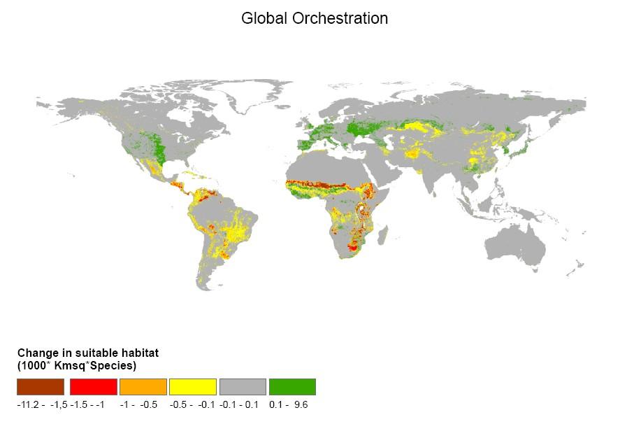
26 Projected HSM: analytical framework Food crops Climate change Energy crops Livestock Land use change Species suitable habitat Species Range
27 Projected HSM: MEA scenarios story-lines Globalised Techno-Garden: Emphasis on green technology. 8.8 billions people* Proactive Environmental policies Adapting mosaic: Emphasis on local governance and sustainability. 9.5 billions people* Global Orchestration: Emphasis on economic growth and public goods. 8.1 billions people* Order from Strength: Emphasis on national economic growth. 9.6 billions people* Reactive Environmental policies Regionalised *Global population in 2050

28 Projected HSM: MEA scenarios land claim

29 Results: projected habitat loss of mammals


30
31 Projected HSM: policy implications CBD target neither met in 2010 nor in the future for any scenario Mammal biodiversity loss will accelerate if the more severe scenarios are realized Detrimental effect of energy crop plantations
 Theme issue 'Global strategies for the conservation of mammals'.")
32 FREE ONLINE Rondinini, C., Rodrigues, A.S.L. & Boitani L. (2011) Theme issue 'Global strategies for the conservation of mammals'. Philosophical Transactions of the Royal Society B, 366 (1578).
33 Thanks to Simon Stuart, Jan Schipper, Mike Hoffmann, the mammal IUCN-SSC SGs, GMA data contributors and workshop facilitators and all the other individuals involved in various stages of the collection of the global mammal data published on the IUCN Red List of Threatened Species
Carlo Rondinini. Effectiveness of African protected areas for the conservation of large mammals
 Carlo Rondinini Effectiveness of African protected areas for the conservation of large mammals Remote Sensing and Conservation, Zological Society of London, 22-23 May 2014 Increase of large mammal extinction
Outline. - Background of coastal and marine conservation - Species distribution modeling (SDM) - Reserve selection analysis. - Results & discussion
 - Reserve selection analysis. - Results & discussion") Application of GIS for data preparation and modeling for coastal and marine conservation planning in Madagascar Rija Rajaonson Technical Assistant, REBIOMA Wildlife Conservation Society Madagascar Outline
Application of GIS for data preparation and modeling for coastal and marine conservation planning in Madagascar Rija Rajaonson Technical Assistant, REBIOMA Wildlife Conservation Society Madagascar Outline
Global Environment Facility - Integrating Watershed & Coastal Areas Management (GEF-IWCAM): Andros Demonstration Site
: Andros Demonstration Site") Global Environment Facility - Integrating Watershed & Coastal Areas Management (GEF-IWCAM): Andros Demonstration Site Coastal Aquifer Management in Small Island Developing States of the Caribbean: Challenges
Global Environment Facility - Integrating Watershed & Coastal Areas Management (GEF-IWCAM): Andros Demonstration Site Coastal Aquifer Management in Small Island Developing States of the Caribbean: Challenges
South Africa. January About this Report and the World Database on Protected Areas (WDPA)
") WDPA Data Status Report About this Report and the World Database on Protected Areas (WDPA) Map showing protected areas in the WDPA South Africa January 2015 The WDPA is the most comprehensive global dataset
WDPA Data Status Report About this Report and the World Database on Protected Areas (WDPA) Map showing protected areas in the WDPA South Africa January 2015 The WDPA is the most comprehensive global dataset
The GeoCLIM software for gridding & analyzing precipitation & temperature. Tamuka Magadzire, FEWS NET Regional Scientist for Southern Africa
 The GeoCLIM software for gridding & analyzing precipitation & temperature Tamuka Magadzire, FEWS NET Regional Scientist for Southern Africa Outline What is GeoCLIM GeoCLIM Development Team GeoCLIM: objectives
Bahamas. January About this Report and the World Database on Protected Areas (WDPA)
") WDPA Data Status Report About this Report and the World Database on Protected Areas (WDPA) Map showing protected areas in the WDPA Bahamas January 15 The WDPA is the most comprehensive global dataset on
WDPA Data Status Report About this Report and the World Database on Protected Areas (WDPA) Map showing protected areas in the WDPA Bahamas January 15 The WDPA is the most comprehensive global dataset on
Tanzania. January About this Report and the World Database on Protected Areas (WDPA)
") WDPA Data Status Report About this Report and the World Database on Protected Areas (WDPA) Map showing protected areas in the WDPA Tanzania January 2015 The WDPA is the most comprehensive global dataset
WDPA Data Status Report About this Report and the World Database on Protected Areas (WDPA) Map showing protected areas in the WDPA Tanzania January 2015 The WDPA is the most comprehensive global dataset
Gambia Gap Analysis and Spatial Conservation Prioritisation
 Protected Areas Resilient to Climate Change, PARCC West Africa Communication Strategy (PARCC Activity 4.2) Ver. 1. 2015 Gambia Gap Analysis and Spatial Conservation Prioritisation ENGLISH Robert J Smith
Accounting for Ecosystem and Biodiversity Related Themes in Uganda
 Introduction Accounting for Ecosystem and Biodiversity Related Themes in Uganda Calls for more evidence-based approaches to policy have increased the need for integrated environmental-economic information
Ghana. January About this Report and the World Database on Protected Areas (WDPA)
") WDPA Data Status Report About this Report and the World Database on Protected Areas (WDPA) Map showing protected areas in the WDPA Ghana January 2015 The WDPA is the most comprehensive global dataset on
WDPA Data Status Report About this Report and the World Database on Protected Areas (WDPA) Map showing protected areas in the WDPA Ghana January 2015 The WDPA is the most comprehensive global dataset on
Belize. January About this Report and the World Database on Protected Areas (WDPA)
") WDPA Data Status Report About this Report and the World Database on Protected Areas (WDPA) Map showing protected areas in the WDPA Belize January 2015 The WDPA is the most comprehensive global dataset
WDPA Data Status Report About this Report and the World Database on Protected Areas (WDPA) Map showing protected areas in the WDPA Belize January 2015 The WDPA is the most comprehensive global dataset
Empowered lives. Resilient nations. Data for People and Planet. powered by
 Empowered lives. Resilient nations. Data for People and Planet powered by Overview As we enter the fourth industrial revolution, technology is revolutionizing our ability to map nature. Satellite data
Suriname. January About this Report and the World Database on Protected Areas (WDPA)
") WDPA Data Status Report About this Report and the World Database on Protected Areas (WDPA) Map showing protected areas in the WDPA Suriname January 2015 The WDPA is the most comprehensive global dataset
WDPA Data Status Report About this Report and the World Database on Protected Areas (WDPA) Map showing protected areas in the WDPA Suriname January 2015 The WDPA is the most comprehensive global dataset
Among various open-source GIS programs, QGIS can be the best suitable option which can be used across partners for reasons outlined below.
 Comparison of Geographic Information Systems (GIS) software As of January 2018, WHO has reached an agreement with ESRI (an international supplier of GIS software) for an unlimited use of ArcGIS Desktop
Fiji. January About this Report and the World Database on Protected Areas (WDPA)
") WDPA Data Status Report About this Report and the World Database on Protected Areas (WDPA) Map showing protected areas in the WDPA Fiji January 2015 The WDPA is the most comprehensive global dataset on
WDPA Data Status Report About this Report and the World Database on Protected Areas (WDPA) Map showing protected areas in the WDPA Fiji January 2015 The WDPA is the most comprehensive global dataset on
Cook Islands. January About this Report and the World Database on Protected Areas (WDPA)
") WDPA Data Status Report About this Report and the World Database on Protected Areas (WDPA) Map showing protected areas in the WDPA Cook Islands January 215 The WDPA is the most comprehensive global dataset
WDPA Data Status Report About this Report and the World Database on Protected Areas (WDPA) Map showing protected areas in the WDPA Cook Islands January 215 The WDPA is the most comprehensive global dataset
Mapping and Assessment of Ecosystems and their Services
 Mapping and Assessment of Ecosystems and their Services ALTER-Net Conference 2013: Science underpinning the EU 2020 Biodiversity Strategy. April 2013 Gent Joachim MAES 1 This presentation is based on the
FAO GAEZ Data Portal
 FAO GAEZ Data Portal www.fao.org/nr/gaez Renato Cumani Environment Officer Land and Water Division Natural Resources Management and Environment Department Food and Agriculture Organization of the UN October
THE GLOBAL INDICATOR FRAMEWORK: NEW AND INNOVATIVE METHODS FOR DISAGGREGATIN BY GEOLOCATION
 Parallel Session: Measuring and Monitoring the SDGs: THE GLOBAL INDICATOR FRAMEWORK: NEW AND INNOVATIVE METHODS FOR DISAGGREGATIN BY GEOLOCATION from global to regional to national panorama 8 th Meeting
Ethiopia. January About this Report and the World Database on Protected Areas (WDPA)
") WDPA Data Status Report About this Report and the World Database on Protected Areas (WDPA) Map showing protected areas in the WDPA Ethiopia January 2015 The WDPA is the most comprehensive global dataset
WDPA Data Status Report About this Report and the World Database on Protected Areas (WDPA) Map showing protected areas in the WDPA Ethiopia January 2015 The WDPA is the most comprehensive global dataset
National assessment on member s readiness to produce indicators
 Inter-Agency and Expert Group on the Sustainable Development Goal Indicators WORKING GROUP ON GEOSPATIAL INFORMATION Fifth expert meeting 5 and 8 December 2018 8 th Meeting of IAEG-SDGs 5 8 November 2018,
Vanuatu. January About this Report and the World Database on Protected Areas (WDPA)
") WDPA Data Status Report About this Report and the World Database on Protected Areas (WDPA) Map showing protected areas in the WDPA Vanuatu January 2015 The WDPA is the most comprehensive global dataset
WDPA Data Status Report About this Report and the World Database on Protected Areas (WDPA) Map showing protected areas in the WDPA Vanuatu January 2015 The WDPA is the most comprehensive global dataset
Mali. January About this Report and the World Database on Protected Areas (WDPA)
") WDPA Data Status Report About this Report and the World Database on Protected Areas (WDPA) Map showing protected areas in the WDPA Mali January 2015 The WDPA is the most comprehensive global dataset on
WDPA Data Status Report About this Report and the World Database on Protected Areas (WDPA) Map showing protected areas in the WDPA Mali January 2015 The WDPA is the most comprehensive global dataset on
Biodiversity and Protected Areas Management Project
 Biodiversity and Protected Areas Management Project Technical Advisor ESA region: Selwyn Willoughby Coordinator ESA region: Christine Mentzel FlexiCadastre EMEA Regional User Conference, Cape Town, South
Python Scripting for Regional Land Use Data Management and QC Workflow
 Python Scripting for Regional Land Use Data Management and QC Workflow 2015 ESRI User Conference July 21, 2015 San Diego, CA Jung Seo, Frank Wen, Simon Choi and Tom Vo Research & Analysis Southern California
ACRONYMS AREAS COUNTRIES MARINE TERMS
 Natura 2000 ACRONYMS AREAS COUNTRIES MARINE TERMS DEFINITION A European network of protected sites under the European Habitats and Birds Directives, aiming to protect the most valuable and threatened European
Multifunctional theory in agricultural land use planning case study
 Multifunctional theory in agricultural land use planning case study Introduction István Ferencsik (PhD) VÁTI Research Department, iferencsik@vati.hu By the end of 20 th century demands and expectations
3.3 Threats to Biodiversity
 Name: Date: Class: IB Environmental Systems and Societies 3.3 Threats to Biodiversity Significant ideas: While global biodiversity is difficult to quantify, it is decreasing rapidly due to human activity.
Cameroon. January About this Report and the World Database on Protected Areas (WDPA)
") WDPA Data Status Report About this Report and the World Database on Protected Areas (WDPA) Map showing protected areas in the WDPA Cameroon January 2015 The WDPA is the most comprehensive global dataset
WDPA Data Status Report About this Report and the World Database on Protected Areas (WDPA) Map showing protected areas in the WDPA Cameroon January 2015 The WDPA is the most comprehensive global dataset
CalWeedMapper. Mapping the Spread of Invasive Plant Species. Karsten Vennemann. Seattle
 CalWeedMapper Mapping the Spread of Invasive Plant Species Karsten Vennemann Seattle Talk Overview The CalWeedMapper Project this presentation is about the expert online editing tool (part of larger project)
Transactions on Information and Communications Technologies vol 18, 1998 WIT Press, ISSN
 STREAM, spatial tools for river basins, environment and analysis of management options Menno Schepel Resource Analysis, Zuiderstraat 110, 2611 SJDelft, the Netherlands; e-mail: menno.schepel@resource.nl
Congo. January About this Report and the World Database on Protected Areas (WDPA)
") WDPA Data Status Report About this Report and the World Database on Protected Areas (WDPA) Map showing protected areas in the WDPA Congo January 2015 The WDPA is the most comprehensive global dataset on
WDPA Data Status Report About this Report and the World Database on Protected Areas (WDPA) Map showing protected areas in the WDPA Congo January 2015 The WDPA is the most comprehensive global dataset on
GIS and Coastal Nutrients Luke Cole
 GIS and Coastal Nutrients Luke Cole Human population density has been widely utilized as a valid predictor of terrestrial nitrogen loads into marine systems. As 50% of the world s population lives within
Equatorial Guinea. January About this Report and the World Database on Protected Areas (WDPA)
") WDPA Data Status Report About this Report and the World Database on Protected Areas (WDPA) Map showing protected areas in the WDPA Equatorial Guinea January 2015 The WDPA is the most comprehensive global
WDPA Data Status Report About this Report and the World Database on Protected Areas (WDPA) Map showing protected areas in the WDPA Equatorial Guinea January 2015 The WDPA is the most comprehensive global
Chitra Sood, R.M. Bhagat and Vaibhav Kalia Centre for Geo-informatics Research and Training, CSK HPKV, Palampur , HP, India
 APPLICATION OF SPACE TECHNOLOGY AND GIS FOR INVENTORYING, MONITORING & CONSERVATION OF MOUNTAIN BIODIVERSITY WITH SPECIAL REFERENCE TO MEDICINAL PLANTS Chitra Sood, R.M. Bhagat and Vaibhav Kalia Centre
GMES Service for Geospatial Reference Data Access (RDA) Covering Areas Outside Europe
 Covering Areas Outside Europe") INSPIRE Conference 2011 Edinburgh 27 June - 1 July GMES Service for Geospatial Reference Data Access (RDA) Covering Areas Outside Europe Andrea Ajmar, Simone Balbo, Piero Boccardo, Simone Dalmasso, Anna
INSPIRE Conference 2011 Edinburgh 27 June - 1 July GMES Service for Geospatial Reference Data Access (RDA) Covering Areas Outside Europe Andrea Ajmar, Simone Balbo, Piero Boccardo, Simone Dalmasso, Anna
The Thresholds working Group.
 A Report for the CEESP on the Key Biodiversity Areas (KBA) Delineation Workshop organized by the IUCN during 10-15 March 2013, Front Royal, Virginia, USA. The joint task force of the World Commission of
Using Big Interagency Databases to Identify Climate Refugia for Idaho s Species of Concern
 Using Big Interagency Databases to Identify Climate Refugia for Idaho s Species of Concern What is a Climate Refugia? habitat that supports a locally reproducing population [or key life history stage]
INDICATORS FOR INTEGRATED COASTAL ZONE MANAGEMENT (ICZM)
") IOC UNESCO / Leader Task 4.1 Contact Francesca Santoro, Julian Barbiere E-mail: f.santoro@unesco.org, j.barbiere@unesco.org Phone: +33 1 45683952 How to cite this factsheet: PEGASO Consortium. 2013. Area
IOC UNESCO / Leader Task 4.1 Contact Francesca Santoro, Julian Barbiere E-mail: f.santoro@unesco.org, j.barbiere@unesco.org Phone: +33 1 45683952 How to cite this factsheet: PEGASO Consortium. 2013. Area
Monitoring of Tropical Deforestation and Land Cover Changes in Protected Areas: JRC Perspective
 Monitoring of Tropical Deforestation and Land Cover Changes in Protected Areas: JRC Perspective Z. Szantoi, A. Brink, P. Mayaux, F. Achard Monitoring Of Natural resources for DEvelopment (MONDE) Joint
Building capacity to support decisionmaking for protection and management of marine areas
 Credit_Deep Atlantic Stepping Stones Science Team_IFE_URI_NOAA_no3 Credit: John Weller, john@lastocean.com Credit: John Weller, john@lastocean.com Credit: John Weller, john@lastocean.com Credit: Sarah
Using the Stock Hydrology Tools in ArcGIS
 Using the Stock Hydrology Tools in ArcGIS This lab exercise contains a homework assignment, detailed at the bottom, which is due Wednesday, October 6th. Several hydrology tools are part of the basic ArcGIS
Management Planning & Implementation of Communication Measures for Terrestrial Natura 2000 Sites in the Maltese Islands Epsilon-Adi Consortium
 Management Planning & Implementation of Communication Measures for Terrestrial Natura 2000 Sites in the Maltese Islands Epsilon-Adi Consortium Briefing Meetings, February 2013 CT3101/2011, MEPA, Malta
GLOBWETLAND AFRICA TOOLBOX
 The GlobWetland Africa Toolbox is an open source and free-of-charge software toolbox for inventorying, mapping, monitoring and assessing wetlands. The toolbox comes with end-to-end processing workflows
Biodiversity and Ecosystem services Thinking globally, acting locally
 Biodiversity and Ecosystem services Thinking globally, acting locally Anne-Gaelle Ausseil - Manaaki Whenua Landcare Research Geoff Hicks National Commission for UNESCO 1 8 / 1 0 / 2 0 1 8 M A N A A K I
Development of an International Arctic Observations Assessment Framework
 Development of an International Arctic Observations Assessment Framework Dr. Steven Lev, Dr. Jason Gallo Briefing for the Sustaining Arctic Observing Networks (SAON) April 7, 2017 International Partners
GEOGRAPHIC INFORMATION SYSTEMS AND IT SOLUTIONS FOR THE ENVIRONMENT
 GEOGRAPHIC INFORMATION SYSTEMS AND IT SOLUTIONS FOR THE ENVIRONMENT Mission We focus on Solutions is a worldwide operating business offering Geographic Information Systems and IT solutions to assist environmental
USING HYPERSPECTRAL IMAGERY
 USING HYPERSPECTRAL IMAGERY AND LIDAR DATA TO DETECT PLANT INVASIONS 2016 ESRI CANADA SCHOLARSHIP APPLICATION CURTIS CHANCE M.SC. CANDIDATE FACULTY OF FORESTRY UNIVERSITY OF BRITISH COLUMBIA CURTIS.CHANCE@ALUMNI.UBC.CA
Geospatial workflows and potential applications to the Sustainable Development Goals of countries in West Asia
 Geospatial workflows and potential applications to the Sustainable Development Goals of countries in West Asia Ameer Abdulla, PhD Senior Advisor, European Topic Center for Spatial Analysis, Spain Associate
Module 3 Indicator Land Consumption Rate to Population Growth Rate
 Regional Training Workshop on Human Settlement Indicators Module 3 Indicator 11.3.1 Land Consumption Rate to Population Growth Rate Dennis Mwaniki Global Urban Observatory, Research and Capacity Development
Interim (5 km) High-Resolution Wind Resource Map for South Africa
 High-Resolution Wind Resource Map for South Africa") Interim (5 km) High-Resolution Wind Resource Map for South Africa Metadata and further information October 2017 METADATA Data set name Interim (5 km) High-Resolution Wind Resource Map for South Africa
Interim (5 km) High-Resolution Wind Resource Map for South Africa Metadata and further information October 2017 METADATA Data set name Interim (5 km) High-Resolution Wind Resource Map for South Africa
Creating an e-flora for South Africa
 SANBI POLICY DOCUMENT DIVISION: Biosystematics Research and Biodiversity Collections EFFECTIVE DATE: 1 April 2014 Compiler: Marianne le Roux & Janine Victor POLICY NUMBER: LAST AMENDED: Creating an e-flora
Applying Earth System Forecasts For Climate Change To Inform Conservation Planning Of The East African Great Lakes
 Applying Earth System Forecasts For Climate Change To Inform Conservation Planning Of The East African Great Lakes S. Asefi, D. Lawrence, P. Lawrence, A. Seimon, S. Talbot 1- University Of Virginia Department
Summary Description Municipality of Anchorage. Anchorage Coastal Resource Atlas Project
 Summary Description Municipality of Anchorage Anchorage Coastal Resource Atlas Project By: Thede Tobish, MOA Planner; and Charlie Barnwell, MOA GIS Manager Introduction Local governments often struggle
Popular Mechanics, 1954
 Introduction to GIS Popular Mechanics, 1954 1986 $2,599 1 MB of RAM 2017, $750, 128 GB memory, 2 GB of RAM Computing power has increased exponentially over the past 30 years, Allowing the existence of
Delineation of Watersheds
 Delineation of Watersheds Adirondack Park, New York by Introduction Problem Watershed boundaries are increasingly being used in land and water management, separating the direction of water flow such that
EXTINCTION CALCULATING RATES OF ORIGINATION AND EXTINCTION. α = origination rate Ω = extinction rate
 EXTINCTION CALCULATING RATES OF ORIGINATION AND EXTINCTION α = origination rate Ω = extinction rate 1 SPECIES AND GENERA EXTINCTION CURVES INDICATE THAT MOST SPECIES ONLY PERSIST FOR A FEW MILLION YEARS.
Application of WebGIS and VGI for Community Based Resources Inventory. Jihn-Fa Jan Department of Land Economics National Chengchi University
 Application of WebGIS and VGI for Community Based Resources Inventory Jihn-Fa Jan Department of Land Economics National Chengchi University OUTLINE Introduction Methodology Results Conclusions 2 MOTIVATION
LandScan Global Population Database
 LandScan Global Population Database The World s Finest Population Distribution Data Uncommon information. Extraordinary places. LandScan Global Population Database East View Cartographic is now offering
SEEA Experimental Ecosystem Accounting
 SEEA Experimental Ecosystem Accounting Sokol Vako United Nations Statistics Division Training for the worldwide implementation of the System of Environmental Economic Accounting 2012 - Central Framework
Geographical Information Systems
 Geographical Information Systems Geographical Information Systems (GIS) is a relatively new technology that is now prominent in the ecological sciences. This tool allows users to map geographic features
Web Portal to European Soil Database
 Web Portal to European Soil Database A step towards harmonization of Soil Information in Europe Marc Van Liedekerke, Panos Panagos, Jean Dusart Soils Portal: http://eusoils.jrc.it Data The European Soil
You are Building Your Organization s Geographic Knowledge
 You are Building Your Organization s Geographic Knowledge And Increasingly Making it Available Sharing Data Publishing Maps and Geo-Apps Developing Collaborative Approaches Citizens Knowledge Workers Analysts
Spatial Effects on Current and Future Climate of Ipomopsis aggregata Populations in Colorado Patterns of Precipitation and Maximum Temperature
 A. Kenney GIS Project Spring 2010 Amanda Kenney GEO 386 Spring 2010 Spatial Effects on Current and Future Climate of Ipomopsis aggregata Populations in Colorado Patterns of Precipitation and Maximum Temperature
First Meeting of the Expert Group on Environment Statistics New York, March 2014
 First Meeting of the Expert Group on Environment Statistics New York, 26-28 March 2014 Experiences on the application of the new FDES Anand Sookun asookun@gmail.com Mauritius Contents Mauritius Old FDES
Amphibian Conservation and GIS
 Allen Hamilton Dr. August/Dr. Wang 12/11/13 Amphibian Conservation and GIS Amphibian populations have been on the decline in recent years, partly due to climate change, increase in mortality and loss of
Lessons Learned from the production of Gridded Population of the World Version 4 (GPW4) Columbia University, CIESIN, USA EFGS October 2014
 Columbia University, CIESIN, USA EFGS October 2014") Lessons Learned from the production of Gridded Population of the World Version 4 (GPW4) Columbia University, CIESIN, USA EFGS October 2014 Gridded Population of the World Gridded (raster) data product
Lessons Learned from the production of Gridded Population of the World Version 4 (GPW4) Columbia University, CIESIN, USA EFGS October 2014 Gridded Population of the World Gridded (raster) data product
GIS and Remote Sensing
 Spring School Land use and the vulnerability of socio-ecosystems to climate change: remote sensing and modelling techniques GIS and Remote Sensing Katerina Tzavella Project Researcher PhD candidate Technology
UNSD SEEA-EEA revision 2020
 UNSD SEEA-EEA revision 2020 Area 1: Spatial units; introduction Sjoerd Schenau, Patrick Bogaart, Edwin Horlings London group meeting, October 2018 Overview Spatial units in SEEA EEA Main revision issues
African Coastal Atlas developments. 10 July 2008 EEA Copenhagen, Denmark
 African Coastal Atlas developments 10 July 2008 EEA Copenhagen, Denmark Africa Overview Africa has approximately 40 000 km of coast across 32 mainland countries and four island states. Africa's coastal
An Internet-based Agricultural Land Use Trends Visualization System (AgLuT)
") An Internet-based Agricultural Land Use Trends Visualization System (AgLuT) Prepared for Missouri Department of Natural Resources Missouri Department of Conservation 07-01-2000-12-31-2001 Submitted by
An Internet-based Agricultural Land Use Trends Visualization System (AgLuT) Prepared for Missouri Department of Natural Resources Missouri Department of Conservation 07-01-2000-12-31-2001 Submitted by
Moving Toward a Scale Independent Approach to Monitoring Status and Trends in Biodiversity
 Moving Toward a Scale Independent Approach to Monitoring Status and Trends in Biodiversity Elizabeth T. Kennedy, Conservation International Environmental Evaluator's Networking Forum June 12, 2008 Guidance
Training on national land cover classification systems. Toward the integration of forest and other land use mapping activities.
 Training on national land cover classification systems Toward the integration of forest and other land use mapping activities. Guiana Shield 9 to 13 March 2015, Paramaribo, Suriname Background Sustainable
世界在线植物志 (World Flora Online) 项目介绍
 项目介绍") Global Strategy for Plant Conservation 世界在线植物志 (World Flora Online) 项目介绍 覃海宁 中国科学院植物研究所 Email: hainingqin@ibcas.ac.cn Website: www.cvh.org.cn #gppc Global Strategy for Plant Conservation A programme of
Global Strategy for Plant Conservation 世界在线植物志 (World Flora Online) 项目介绍 覃海宁 中国科学院植物研究所 Email: hainingqin@ibcas.ac.cn Website: www.cvh.org.cn #gppc Global Strategy for Plant Conservation A programme of
8 th Meeting of IAEG-SDGs 5 8 November 2018, Stockholm, Sweden. Meetings. Report
 Meetings 8 th Meeting of IAEG-SDGs Between April 2018 and November 2018, the Working Group on Geospatial Information of the IAEG- SDGs held two online meetings; presented a report to the United Nations
ENV208/ENV508 Applied GIS. Week 1: What is GIS?
 ENV208/ENV508 Applied GIS Week 1: What is GIS? 1 WHAT IS GIS? A GIS integrates hardware, software, and data for capturing, managing, analyzing, and displaying all forms of geographically referenced information.
The UN-GGIM: Europe core data initiative to encourage Geographic information supporting Sustainable Development Goals Dominique Laurent, France
 INSPIRE conference Strasbourg 6 September 2017 The UN-GGIM: Europe core data initiative to encourage Geographic information supporting Sustainable Development Goals Dominique Laurent, France Introduction
Asia Protected Areas Charter
 資料 3-1 Asia Protected Areas Charter The Asia Challenge Asia is the world s most rapidly growing region as well as one of the most bio-diverse. This dynamic development has led to unprecedented growth,
 Title Generation of DEM for Urban Vietnam Transfo Author(s) Yonezawa, Go Citation Kyoto Working Papers on Area Studie 60: 1-10 Issue Date 2009-03 URL http://hdl.handle.net/2433/155764 Right 2009 Center
Ants in the Heart of Borneo a unique possibility to join taxonomy, ecology and conservation
 Ants in the Heart of Borneo a unique possibility to join taxonomy, ecology and conservation Carsten Brühl, University Landau, Germany 1 Borneo Interior mountain ranges of Central Borneo represent the only
Urban Spatial Scenario Design Modelling (USSDM) in Dar es Salaam: Background Information
 in Dar es Salaam: Background Information") Urban Spatial Scenario Design Modelling (USSDM) in Dar es Salaam: Background Information Modelling urban settlement dynamics in Dar es Salaam Revision: 2 (July 2013) Prepared by: Katja Buchta TUM team
Urban Spatial Scenario Design Modelling (USSDM) in Dar es Salaam: Background Information Modelling urban settlement dynamics in Dar es Salaam Revision: 2 (July 2013) Prepared by: Katja Buchta TUM team
Conserving freshwater ecosystem values in Tasmania, Australia: identification and application of freshwater conservation management priority areas
 Conserving freshwater ecosystem values in Tasmania, Australia: identification and application of freshwater conservation management priority areas Danielle Hardie 1 and Peter Davies 2 1 Department of Primary
UN-GGIM: Europe ExCom 1 June 2016 Francfort Work Group A «Core Data» Status and Progress François Chirié, France
 UN-GGIM: Europe ExCom 1 June 2016 Francfort Work Group A «Core Data» Status and Progress François Chirié, France Plan The Core Data Scope Deliverable 7-8 June 2016 WGA workshop to investigate work plans
Realizing benefits of Spatial Data Infrastructure A user s perspective from Environment Agency - Abu Dhabi
 Realizing benefits of Spatial Data Infrastructure A user s perspective from Environment Agency - Abu Dhabi Anil Kumar Director, Environment Information Management 26 April 2012 Geospatial World Forum,
Strategies for biodiversity conservation
 Institute of Earth Systems University of Malta Strategies for biodiversity conservation Louis F. Cassar PhD Elisabeth Conrad PhD The conservation imperative: perspective Biodiversity hotspot High endemism
Courtesy of John Mitchell
 Shrimp trawl fisheries Marine fish stocks are under increasing threat from a range of spatially based problems that might be natural or involve socio-economic factors. To best manage spatial problems,
Saving the Leuser Ecosystem with Arc GIS
 Brian Mattern APEC 480 Saving the Leuser Ecosystem with Arc GIS Background: Right now, a significant and relatively unreported crisis is occurring on the island of Sumatra. The Leuser ecosystem is a topographically
Global Land Cover Mapping
 Global Land Cover Mapping and its application in SDGs Prof. Chen Jun 1, Dr. He Chaoying 2 1 National Geomatics Center of China (NGCC) 2 Ministry of Natural Resources, P.R.China May 30, 2018, Copenhagen
National Survey on the Natural Environment of Japan. Hajime Hirosawa Biodiversity Center of Japan Ministry of the Environment (MOE)
") National Survey on the Natural Environment of Japan Hajime Hirosawa Biodiversity Center of Japan Ministry of the Environment (MOE) Biodiversity Center of Japan, MOE Establishment: 1998 Purpose: to encourage
National Survey on the Natural Environment of Japan Hajime Hirosawa Biodiversity Center of Japan Ministry of the Environment (MOE) Biodiversity Center of Japan, MOE Establishment: 1998 Purpose: to encourage
Designing a Dam for Blockhouse Ranch. Haley Born
 Designing a Dam for Blockhouse Ranch Haley Born CE 394K GIS in Water Resources Term Paper Fall 2011 Table of Contents Introduction... 1 Data Sources... 2 Precipitation Data... 2 Elevation Data... 3 Geographic
Geographical knowledge and understanding scope and sequence: Foundation to Year 10
 Geographical knowledge and understanding scope and sequence: Foundation to Year 10 Foundation Year 1 Year 2 Year 3 Year 4 Year 5 Year 6 Year level focus People live in places Places have distinctive features
Digitization in a Census
 Topics Connectivity of Geographic Data Sketch Maps Data Organization and Geodatabases Managing a Digitization Project Quality and Control Topology Metadata 1 Topics (continued) Interactive Selection Snapping
INTEGRATED SURVEY FRAMEWORK FOR AGRICULTURAL AND RURAL STATISTICS PIERO DEMETRIO FALORSI, FAO
 INTEGRATED SURVEY FRAMEWORK FOR AGRICULTURAL AND RURAL STATISTICS PIERO DEMETRIO FALORSI, FAO Outline 1.Goals of the Research Activity 2.Concept of Integration 3.Strategic ideas for the Research Activity
Data Collection and GIS Applications
 Data Collection and GIS Applications Governor s s Conference on the Management of the Illinois River System Jeff Jack of all Trades Boeckler, IDNR Introduction Collecting available GIS data sets Creating
FESTF Gopher. A Data Integration Tool to Inform Decisions in FIFRA/ESA Processes
 FESTF Gopher A Data Integration Tool to Inform Decisions in FIFRA/ESA Processes April 26, 2018 CropLife America & RISE Regulatory Conference Arlington, VA An Introduction to FESTF The (FESTF), incorporated
Resolving habitat classification and structure using aerial photography. Michael Wilson Center for Conservation Biology College of William and Mary
 Resolving habitat classification and structure using aerial photography Michael Wilson Center for Conservation Biology College of William and Mary Aerial Photo-interpretation Digitizing features of aerial
ZFL, Center of Remote Sensing of Land Surfaces, University of Bonn, Germany. Geographical Institute, University of Bonn, Germany
 Communication of Research Results The IMPETUS Atlas H.-P. Thamm 1, M. Judex 1, O.Schultz 2, S.Krüger 1 & M. Christoph 3 1 ZFL, Center of Remote Sensing of Land Surfaces, University of Bonn, Germany 2 Geographical
THE 3D SIMULATION INFORMATION SYSTEM FOR ASSESSING THE FLOODING LOST IN KEELUNG RIVER BASIN
 THE 3D SIMULATION INFORMATION SYSTEM FOR ASSESSING THE FLOODING LOST IN KEELUNG RIVER BASIN Kuo-Chung Wen *, Tsung-Hsing Huang ** * Associate Professor, Chinese Culture University, Taipei **Master, Chinese
Ecologically or Biologically Significant Areas (EBSAs) in the Convention on Biological Diversity Arctic EBSA workshop as an example
 in the Convention on Biological Diversity Arctic EBSA workshop as an example") Ecologically or Biologically Significant Areas (EBSAs) in the Convention on Biological Diversity Arctic EBSA workshop as an example Ville Karvinen / SYKE HELCOM STATE & CONSERVATION 3-2015 12.11.2015 CBD
Ecologically or Biologically Significant Areas (EBSAs) in the Convention on Biological Diversity Arctic EBSA workshop as an example Ville Karvinen / SYKE HELCOM STATE & CONSERVATION 3-2015 12.11.2015 CBD
Living Atlas: Road Ahead. Deane Kensok Sean Breyer
 Living Atlas: Road Ahead Deane Kensok Sean Breyer Workshop Agenda Subhead Here Overview of the Living Atlas Esri Content Portfolio - Overview - Road Map for 2017 and Beyond - Demos: Previews of Online