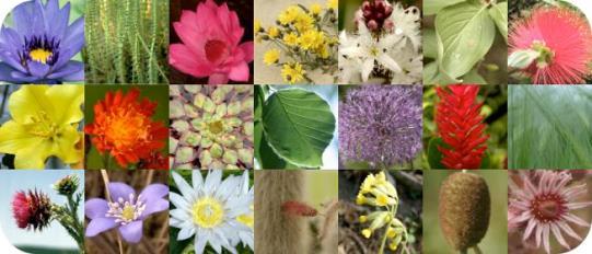
世界在线植物志 (World Flora Online) 项目介绍
|
|
|
- Caroline Cooper
- 5 years ago
- Views:
Transcription
1 Global Strategy for Plant Conservation 世界在线植物志 (World Flora Online) 项目介绍 覃海宁 中国科学院植物研究所 Website: #gppc

2 Global Strategy for Plant Conservation A programme of the Convention on Biological Diversity Aims: 1. Plant diversity is well understood, documented and recognized 2. Plant diversity is urgently and effectively conserved 3. Plant diversity is used in a sustainable and equitable manner 4. Education and awareness about plant diversity, its role in sustainable livelihoods and importance to all life on Earth is promoted 5. The capacities and public engagement necessary to implement the Strategy have been developed.

3 Global Strategy for Plant Conservation Adopted in biodiversity Targets 2010 aimed to reduce biodiversity loss by 2010 Objective 1 Plant diversity is well understood, documented and recognized Target 1 A working list of known plant species, as a step towards a complete world flora... The Plant List


4 Global Strategy for Plant Conservation Updated 29 Oct. 2010, Nagoya, Japan revised biodiversity Targets 2020 Target 1 aiming to halt biodiversity loss by An online flora of all known plants...the World Flora Online A widely accessible Flora of all known plants is a fundamental requirement for conservation and provides a baseline for the achievement and monitoring of other targets of the GSPC
5 The GSPC T Old target text New target text A widely accessible working list of known plant species, as a step towards a complete world flora A preliminary assessment of the conservation status of all known plant species, at national, regional and international levels Development of models with protocols for plant conservation and sustainable use, based on research and practical experience At least 10 per cent of each of the world s ecological regions effectively conserved Protection of 50 per cent of the most important areas for plant diversity assured At least 30 per cent of production lands managed consistent with the conservation of plant diversity 60 per cent of the world s threatened species conserved in situ 60 per cent of threatened plant species An online flora of all known plants An assessment of the conservation status of all known plant species, as far as possible, to guide conservation action Information, research and associated outputs, and methods necessary to implement the Strategy developed and shared At least 15 per cent of each ecological region or vegetation type secured through effective management and/or restoration At least 75 per cent of the most important areas for plant diversity of each ecological region protected with effective management in place for conserving plants and their genetic diversity At least 75 per cent of production lands in each sector managed sustainably, consistent with the conservation of plant diversity At least 75 per cent of known threatened species conserved in situ


6 World Flora Online Plant Conservation: the need for baseline data Need for fundamental data for assessing conservation priorities A consensus list of plant taxa for communication on national/global levels Identification tools for these taxa - keys/images/descriptions Occurrence and geographic distribution - rarity/decline

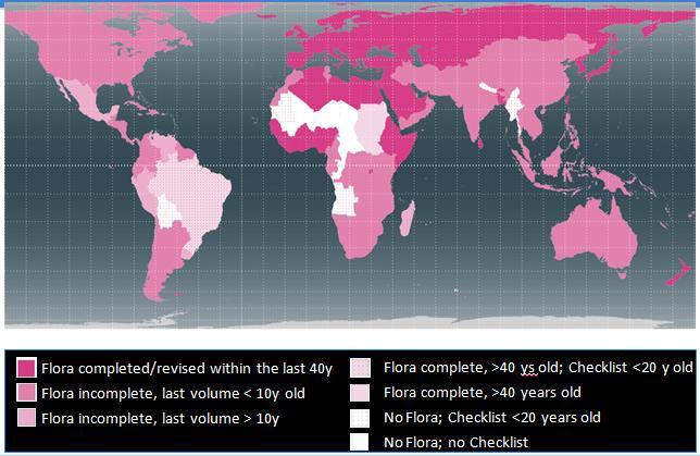
7 Target 2: An assessment of the conservation status of all known plant species, as far as possible, to guide conservation action Global assessments using IUCN criteria complete only for 3-4% of flowering plants = countries with Red List <10 years old = countries with Red List >10 years old

8 Target 1: An online flora of all known plants Summary Statistics The Plant List includes 1,040,426 scientific plant names of species rank. Of these 298,900 are accepted species names. Status Total Accepted 298, % Synonym 477, % Unresolved 263, % Next step 2020: Online World Flora
9 Target 1: An online flora of all known plants Royal Botanic Gardens, Kew nominated as lead facilitating agency for Target 1 Over 120 institutions and individuals from over 25 countries are working towards meeting the Target
10 Major constraint: 2020 deadline Have to work with existing knowledge to achieve target by 2020 No time for biology or taxonomy Comparisons with existing floristic projects Has taken 10 years to compile checklist of Antioquia, 35 years for Flora of North America
11 Major asset: Existing data 250+ years of published floras, treatments, monographs Some published electronically, most printed Biodiversity Heritage Library has efficient pipeline for digitization APG to define family-level framework The Plant List to define list of species TPL needs continuous updates


12 The World Flora Online Endorsed by... Global Partnership for Plant Conservation, St. Louis, July th International Botanical Congress, Melbourne, July 2011 CBD SBSTTA 16, Montreal, May 2012 CBD COP 11, Hyderabad, October 2012
13 Announcement (St. Louis, April, 22, 2012)

14 World Flora Online - where are we now? Global consortium of >30 leading plant systematics institutes MOU has been approved and in process of being signed WFO approved at CBD COP 11 Hyderabad, Oct Technical Working Group established: use cases and data definition Taxonomic Working Group established: knowledge gap analysis Consortium meeting in Edinburgh, November 2013


15 WFO 2 nd Council Meeting, June, 2014 Komarov Botanical Institute, St. Petersburg
16 Components of WFO Name & synonymy * Description * Identification tools References* To other floras & supporting data Distribution * Literature-based, specimen-based Conservation status Images Illustrations, photos, specimen images Notes * = required, others optional


17 World Flora Online How to? A website bringing together available basic floristic information with links to more detailed information from data providers and other biodiversity data sources global in scope, will include mosses, liverworts and higher plants National Floras Regional Floras Monographs World Online Flora core fields supplementary fields JSTOR Plants
18 WFO: A Network of Networks World Flora Online Portal Standardised data retrieval mechanism Monographic Slice Networks Regional / Country Networks
19 WFO Main System Parts OCR/PDF MARKUP SYSTEM BULK DATA INGESTION SYSTEM File formats Protocols Name Matching Name Mismatch Resolution Versioning WEB SERVICES WFO PUBLIC WEBSITE Search View Feedback WFO SPECIALISTS WEBSITE????? Content Create Edit FEEDBACK HANDLING PROJECT STATUS Gaps Partners Assignments GLOBAL USER ADMIN & ACCESS CONTROL EXISTING LAYERS TAXONOMIC BACKBONE TAXON MAPPING DATASET REGISTRY & INDEX WFO DATABASE SPATIAL DATABASE Countries GEOGRAPHIC INFORMATION SYSTEM NOMENCLATORS (IPNI, Bryophytes) TAXONOMIC MANAGEMENT SYSTEM FILES Images DATA EXPORT SYSTEM
20 Flow DATA ACQUISTION TEAM PRINTED MATERIALS LIST PRIORITY DECISION PROCESS PRIORITY MATERIALS LIST IS STRUC TURED DATA? INGESTION DIGITIZING & STRUCTURE
21 Backbone Approach Dus bus E FLORA A CONTENT FOR INGESTION Aus bus Aus bus Description s FLORA B FLORA A FLORA C ASTERACEA Aus bus AE Cus bus Dus bus Eus alba Bus alba AE WFO PORTAL - SPECIES PAGE Synonyms Cus bus Dus bus Eus alba BACKBO NE Cus alba Dus alba Gus negra Original Data FLORA A ASTERACE ASTERACE Dus bus ASTERACEAE Aus bus FLORA B Aus bus ASTERACEAE Dus bus WFO DATABASE WFO Record FLORA A Aus bus ASTERACE A Original Record FLORA A Dus bus ASTERACE AE Aus bus WFO Record FLORA B Aus bus ASTERACE AE Original Record FLORA B Aus bus ASTERACE AE Dus bus
22 Who will contribute? Plant scientists Citizen scientists General public More?
23 Administration needed Global leadership team Team of regional managers Editorial committee? Not too big Formatting committee? Not too rigid Need a schema, guidance on what is expected in treatment


24 World Flora Online challenge & opportunities for phytotaxonomists

 Generate de-novo data (gap filling) Undertake")


25 World Flora Online - opportunities Opportunities for plant systematists to: Get organised Contribute digital data & enhance our impact Mobilize non-digital data (print & specimens) Generate de-novo data (gap filling) Undertake capacity building for plant taxonomy Opportunities for users to: Get a global overview of the diversity of plant species Draw upon other works when establishing regional treatments Seeing the global context for conservation planning A tool for practitioners at all levels


26 Our Base and Strategy Resources: electronic and printed; Positive attend via institution and individual

27 Thank you for your attention!
Creating an e-flora for South Africa
 SANBI POLICY DOCUMENT DIVISION: Biosystematics Research and Biodiversity Collections EFFECTIVE DATE: 1 April 2014 Compiler: Marianne le Roux & Janine Victor POLICY NUMBER: LAST AMENDED: Creating an e-flora
Ministry of Health and Long-Term Care Geographic Information System (GIS) Strategy An Overview of the Strategy Implementation Plan November 2009
 Strategy An Overview of the Strategy Implementation Plan November 2009") Ministry of Health and Long-Term Care Geographic Information System (GIS) Strategy An Overview of the Strategy Implementation Plan November 2009 John Hill, Health Analytics Branch Health System Information
Ministry of Health and Long-Term Care Geographic Information System (GIS) Strategy An Overview of the Strategy Implementation Plan November 2009 John Hill, Health Analytics Branch Health System Information
2018/1 The integration of statistical and geospatial information. The Regional Committee of UN-GGIM: Americas:
 The following are the conclusions and recommendations of the Regional Committee of the United Nations on Global Geospatial Information Management for the Americas, during its Fifth Session, Thursday 8
Some Conservation Activities in China Based on the Red List
 6 th EAFES Int l Congress, Session 5 Biodiversity Informatics and Conservation April 10 th, 2014, Huandao Tide Hotel,Haikou, Hainan,China Some Conservation Activities in China Based on the Red List Qin
International Environmental Technology Centre (IETC)
") International Environmental Technology Centre (IETC) UNEP-UNESCO Joint Initiative Cultural and Natural resources management of the Iraqi Marshlands utilizing the World Heritage Nomination process as a
International Environmental Technology Centre (IETC) UNEP-UNESCO Joint Initiative Cultural and Natural resources management of the Iraqi Marshlands utilizing the World Heritage Nomination process as a
Global Plant Name data online: their relevance to horticulture (Part 1) Alan Paton, Rafaël Govaerts, Bob Allkin
 Alan Paton, Rafaël Govaerts, Bob Allkin") Global Plant Name data online: their relevance to horticulture (Part 1) Alan Paton, Rafaël Govaerts, Bob Allkin Overview Brief overview of some global resources Focus on the issues these resources face
Global Plant Name data online: their relevance to horticulture (Part 1) Alan Paton, Rafaël Govaerts, Bob Allkin Overview Brief overview of some global resources Focus on the issues these resources face
An Introduction to Day Two. Linking Conservation and Transportation Planning Lakewood, Colorado August 15-16, 16, 2006
 An Introduction to Day Two Linking Conservation and Transportation Planning Lakewood, Colorado August 15-16, 16, 2006 1 Agenda Day One Transportation Planning Heritage Program State Wildlife Action Plan
The Catalogue of Life: towards an integrative taxonomic backbone for biodiversity. Frank A. Bisby, Yuri R. Roskov
 Nimis P. L., Vignes Lebbe R. (eds.) ù Biodiversity: Progress and Problems pp. 37-42. ISBN 978-88-8303-295-0. EUT, 2010. The Catalogue of Life: towards an integrative taxonomic backbone for biodiversity
Integrated approaches to the implementation of the Convention on Biological Diversity
 Integrated approaches to the implementation of the Convention on Biological Diversity Actions on ABS in the context of UNESCO Biosphere Reserves Vibeke Jensen, Director UNESCO Liaison Office in New York
Empowered lives. Resilient nations. Data for People and Planet. powered by
 Empowered lives. Resilient nations. Data for People and Planet powered by Overview As we enter the fourth industrial revolution, technology is revolutionizing our ability to map nature. Satellite data
An Introduction to NatureServe Linking Conservation and Transportation Planning Phoenix, Arizona November 8 & 9, 2006
 An Introduction to NatureServe Linking Conservation and Transportation Planning Phoenix, Arizona November 8 & 9, 2006 1 NatureServe in Brief An independent, non-profit conservation organization Provides
1. PURPOSE 2. PERIOD OF PERFORMANCE
 Statement of Work Herbarium Voucher Collection Land Management Section, Environmental Security Department Marine Corps Installations West Marine Corps Base Camp Pendleton, California 1. PURPOSE The purpose
Why do we need a global framework for MPAs in ABNJ? Kristina M. Gjerde IUCN High Seas Policy Advisor
 Why do we need a global framework for MPAs in ABNJ? Kristina M. Gjerde IUCN High Seas Policy Advisor kgjerde@eip.com.pl 40% ocean heavily affected by humans (c) Halpern et al. 2008. Scientists found that
Building capacity to support decisionmaking for protection and management of marine areas
 Credit_Deep Atlantic Stepping Stones Science Team_IFE_URI_NOAA_no3 Credit: John Weller, john@lastocean.com Credit: John Weller, john@lastocean.com Credit: John Weller, john@lastocean.com Credit: Sarah
*CETAF : DOI: /RG
 Consortium of European Taxonomic Facilities STRATEGY AND STRATEGIC DEVELOPMENT PLAN * Executive Summary Exploring and documenting diversity in nature *CETAF Strategy and Strategic Development Plan 2015-2025:
Status of implementation of the INSPIRE Directive 2016 Country Fiches. COUNTRY FICHE Ireland
 Status of implementation of the INSPIRE Directive 2016 Country Fiches COUNTRY FICHE Ireland Introduction... 1 1. State of Play... 2 1.1 Coordination... 2 1.2 Functioning and coordination of the infrastructure...
Using Information and Geospatial Technologies to Support Biodiversity Conservation Policy Options in Latin America
 Using Information and Geospatial Technologies to Support Biodiversity Conservation Policy Options in Latin America Cover map credit: Javier Alfonso Racero-Casarrubia Using Information and Geospatial Technologies
8 th Arctic Regional Hydrographic Commission Meeting September 2018, Longyearbyen, Svalbard Norway
 8 th Arctic Regional Hydrographic Commission Meeting 11-13 September 2018, Longyearbyen, Svalbard Norway Status Report of the Arctic Regional Marine Spatial Data Infrastructures Working Group (ARMSDIWG)
THE SEVILLE STRATEGY ON BIOSPHERE RESERVES
 THE SEVILLE STRATEGY ON BIOSPHERE RESERVES 1 VISION FOR BIOSPHERE RESERVES IN THE 21 ST CENTURY The international Seville Conference on Biosphere Reserves, organised by UNESCO, adopted a two-pronged approach,
Priorities for the development of a European taxonomic information system
 Beispielbild Priorities for the development of a European taxonomic information system Cornelia Löhne & Walter Berendsohn Botanischer Garten und Botanisches Museum Berlin-Dahlem Freie Universität Berlin
Status of implementation of the INSPIRE Directive 2016 Country Fiches. COUNTRY FICHE Malta
 Status of implementation of the INSPIRE Directive 2016 Country Fiches COUNTRY FICHE Malta Introduction... 1 1. State of Play... 2 1.1 Coordination... 2 1.2 Functioning and coordination of the infrastructure...
Biodiversity data, current gaps and work package efforts
 Biodiversity data, current gaps and work package efforts Florian T. Wetzel 1, Veljo Runnel 2, Anton Güntsch 3, Urmas Köljalg 2 1 Museum für Naturkunde Berlin - Leibniz Institute for Evolution and Biodiversity
Realizing benefits of Spatial Data Infrastructure A user s perspective from Environment Agency - Abu Dhabi
 Realizing benefits of Spatial Data Infrastructure A user s perspective from Environment Agency - Abu Dhabi Anil Kumar Director, Environment Information Management 26 April 2012 Geospatial World Forum,
Annex I. Common criteria for the choice of Protected Marine and Coastal Areas that could be included in SPAMI list
 Annex I Common criteria for the choice of Protected Marine and Coastal Areas that could be included in SPAMI list PROTOCOL CONCERNING SPECIALLY PROTECTED AREAS AND BIOLOGICAL DIVERSITY IN THE MEDITERRANEAN
Spatial Data Infrastructure Concepts and Components. Douglas Nebert U.S. Federal Geographic Data Committee Secretariat
 Spatial Data Infrastructure Concepts and Components Douglas Nebert U.S. Federal Geographic Data Committee Secretariat August 2009 What is a Spatial Data Infrastructure (SDI)? The SDI provides a basis for
Accounting for Ecosystem and Biodiversity Related Themes in Uganda
 Introduction Accounting for Ecosystem and Biodiversity Related Themes in Uganda Calls for more evidence-based approaches to policy have increased the need for integrated environmental-economic information
EuroGEOSS Protected Areas Pilot
 EuroGEOSS Protected Areas Pilot Max Craglia European Commission Joint Research Centre Part 1: the present MyNatura2000 Mobile app. Awareness raising & volunteered data collection. Natura2000 covers 18%
Chitra Sood, R.M. Bhagat and Vaibhav Kalia Centre for Geo-informatics Research and Training, CSK HPKV, Palampur , HP, India
 APPLICATION OF SPACE TECHNOLOGY AND GIS FOR INVENTORYING, MONITORING & CONSERVATION OF MOUNTAIN BIODIVERSITY WITH SPECIAL REFERENCE TO MEDICINAL PLANTS Chitra Sood, R.M. Bhagat and Vaibhav Kalia Centre
Framework on reducing diffuse pollution from agriculture perspectives from catchment managers
 Framework on reducing diffuse pollution from agriculture perspectives from catchment managers Photo: River Eden catchment, Sim Reaney, Durham University Introduction This framework has arisen from a series
Atlas of Living Scotland New data infrastructure for research and citizen science
 Atlas of Living Scotland New data infrastructure for research and citizen science John Sawyer and Rachel Stroud CEO NBN Trust, j.sawyer@nbn.org.uk Who is the National Biodiversty Network? The National
Economic and Social Council
 United Nations Economic and Social Council Distr.: General 18 July 2016 Original: English Committee of Experts on Global Geospatial Information Management Sixth session New York, 3-5 August 2016 Item 2
15 March 2010 Re: Draft Native Vegetation of the Sydney Metropolitan Catchment Management Authority Area GIS layers and explanatory reports
 SYDNEY COASTAL COUNCILS GROUP Inc. C/- City of Sydney Council Level 14, 456 Kent Street GPO Box 1591, SYDNEY NSW 2001 Phone: (02) 9246 7791 Facsimile: (02) 9265 9660 Email: info@sydneycoastalcouncils.com.au
ACRONYMS AREAS COUNTRIES MARINE TERMS
 Natura 2000 ACRONYMS AREAS COUNTRIES MARINE TERMS DEFINITION A European network of protected sites under the European Habitats and Birds Directives, aiming to protect the most valuable and threatened European
The future of SDIs. Ian Masser
 The future of SDIs Ian Masser Presentation Considers two questions relating to the future development of SDIs throughout the world Where have we got to now? Where should we go from here? Identifies four
Overview. Project Background Project Approach: Content and Application Development Application Demonstration Future Developments
 Overview Project Background Project Approach: Content and Application Development Application Demonstration Future Developments Southeast Pressures: Continued Population Growth Transportation Corridors
Adding value to Copernicus services with member states reference data
 www.eurogeographics.org Adding value to Copernicus services with member states reference data Neil Sutherland neil.sutherland@os.uk GIS in the EU 10 November 2016 Copyright 2016 EuroGeographics 61 member
BIODIVERSITY: STRUCTURE AND FUNCTION Vol. I - Data and Information Management and Communication - Walter G. Berendsohn
 DATA AND INFORMATION MANAGEMENT AND COMMUNICATION Walter G. Freie Universität Berlin, Botanic Garden and Botanical Museum Berlin-Dahlem, Germany Keywords: Biodiversity informatics, biological informatics,
NSDI as a tool for Secure land tenure
 NSDI as a tool for Secure land tenure General Overview To look at the progress in SDI development and its application in policy formulation and impact on land tenure. INTEGRATION OF INFORMATION POLICIES
Spatial Planning for Protected Areas in Response to Climate Change (SPARC)
") Spatial Planning for Protected Areas in Response to Climate Change (SPARC) CI-GEF and Conservation International PROJECT SUMMARY Protected areas are the centerpiece of place-based conservation. The Convention
Spatial Planning for Protected Areas in Response to Climate Change (SPARC) CI-GEF and Conservation International PROJECT SUMMARY Protected areas are the centerpiece of place-based conservation. The Convention
the map Redrawing Donald Hobern takes a look at the challenges of managing biodiversity data [ Feature ]
![the map Redrawing Donald Hobern takes a look at the challenges of managing biodiversity data [ Feature ]](/thumbs/82/86628837.jpg "the map Redrawing Donald Hobern takes a look at the challenges of managing biodiversity data [ Feature ]") Redrawing the map Donald Hobern takes a look at the challenges of managing biodiversity data 46 Volume 12 > Number 9 > 2008 www.asiabiotech.com Cicadetta sp., Canberra, Australia, December 2007 Photograph
Redrawing the map Donald Hobern takes a look at the challenges of managing biodiversity data 46 Volume 12 > Number 9 > 2008 www.asiabiotech.com Cicadetta sp., Canberra, Australia, December 2007 Photograph
Issues in bryophyte conservation and research
 Issues in bryophyte conservation and research Paula Warren Head Office Wellington Craig Miller West Coast Conservancy Hokitika Published by Head Office, PO Box 10-420 Wellington, New Zealand This report
Catchment Guide Appendix 2: Case Studies
 Catchment Guide Appendix 2: Case Studies List of Case Studies 1. Ribble Catchment Online Information 2. Upper Thames Catchment Integrated Local Delivery The Ribble Catchment Question 8: What information
Roadmap to interoperability of geoinformation
 Roadmap to interoperability of geoinformation and services in Europe Paul Smits, Alessandro Annoni European Commission Joint Research Centre Institute for Environment and Sustainability paul.smits@jrc.it
Arctic ecosystem services: TEEB Arctic Scoping study. Alexander Shestakov WWF Global Arctic Programme 3 December Arctic Biodiversity Congress
 Arctic ecosystem services: TEEB Arctic Scoping study Alexander Shestakov WWF Global Arctic Programme 3 December 20143 Arctic Biodiversity Congress Content 1. Project design 2. Approach 3. Challenges and
Urban Climate Resilience
 Urban Climate Resilience in Southeast Asia Partnership Project Introduction Planning for climate change is a daunting challenge for governments in the Mekong Region. Limited capacity at the municipal level,
RHS Libraries. A guide for researchers. RHS Libraries. rhs.org.uk/libraries
 A guide for researchers Lindley Library 020 7821 3050 library.london@rhs.org.uk Wisley Library 01483 212428 library.wisley@rhs.org.uk Harlow Carr Library 01423 724 686 library.harlowcarr@rhs.org.uk rhs.org.uk/libraries
Ministry of ICT of I.R.IRAN
 The ECO 8/6 mill km 2 10 Slamic countries ~330 mill people Oil, Gas, Industries,Tourism 2 Issue transformation in last decade Problem solving needs more integrated approach More interaction &complexity
Motivation for project:
 Motivation for project: Shale Gas exploration and development requested of government by Oil Companies. Shale Gas Development Strategic Environment Assessment (SGD SEA) commissioned by DEA Biodiversity
The Thresholds working Group.
 A Report for the CEESP on the Key Biodiversity Areas (KBA) Delineation Workshop organized by the IUCN during 10-15 March 2013, Front Royal, Virginia, USA. The joint task force of the World Commission of
Proposal for a DIRECTIVE OF THE EUROPEAN PARLIAMENT AND OF THE COUNCIL. establishing an infrastructure for spatial information in the Community
 Proposal for a DIRECTIVE OF THE EUROPEAN PARLIAMENT AND OF THE COUNCIL establishing an infrastructure for spatial information in the Community INSPIRE http://inspire.jrc.it/ Alessandro Annoni 1 EU Commission
Implementation of Inspire in Denmark - How we get it flying! Olav Eggers National Survey & Cadastre -Denmark
 Implementation of Inspire in Denmark - How we get it flying! Olav Eggers oe@kms.dk National Survey & Cadastre -Denmark Introduction Overview Infrastructure for Spatial Information Act National Survey and
ACTION PLAN FOR WORLD HERITAGE IN LATIN AMERICA AND THE CARIBBEAN ( )
") Annex ACTION PLAN FOR WORLD HERITAGE IN LATIN AMERICA AND THE CARIBBEAN (2014-2024) The current Regional Action Plan for Latin America and the Caribbean for 2014-2024 has been elaborated by the State Parties
Annex ACTION PLAN FOR WORLD HERITAGE IN LATIN AMERICA AND THE CARIBBEAN (2014-2024) The current Regional Action Plan for Latin America and the Caribbean for 2014-2024 has been elaborated by the State Parties
INSPIRE - A Legal framework for environmental and land administration data in Europe
 INSPIRE - A Legal framework for environmental and land administration data in Europe Dr. Markus Seifert Bavarian Administration for Surveying and Cadastre Head of the SDI Office Bavaria Delegate of Germany
Economic and Social Council
 United Nations Economic and Social Council Distr.: General 2 July 2012 E/C.20/2012/10/Add.1 Original: English Committee of Experts on Global Geospatial Information Management Second session New York, 13-15
GEO Geohazards Community of Practice
 GEO Geohazards Community of Practice 1) Co-Chair of GHCP With input from: Stuart Marsh, GHCP Co-Chair Francesco Gaetani, GEO Secretariat and many GHCP contributors 1) Nevada Bureau of Mines and Geology
Status of implementation of the INSPIRE Directive 2016 Country Fiches. COUNTRY FICHE Netherlands
 Status of implementation of the INSPIRE Directive 2016 Country Fiches COUNTRY FICHE Netherlands Introduction... 1 1. State of Play... 2 1.1 Coordination... 2 1.2 Functioning and coordination of the infrastructure...
Economic and Social Council
 United Nations E/CN.3/2019/31 Economic and Social Council Distr.: General 19 December 2018 Original: English Statistical Commission Fiftieth session 5-8 March 2019 Item 4(i) of the provisional agenda*
GBIF Global Biodiversity Information Facility. Dmitry Schigel, Tim Hirsch Arctic data and Global Biodiversity Information Facility
 GBIF Global Biodiversity Information Facility Dmitry Schigel, Tim Hirsch Arctic data and Global Biodiversity Information Facility WHAT IS GBIF? Intergovernmental collaboration founded in 2001 on the recommendation
PROGRESS REPORT ON APPROACH PAPER THE IMPLEMENTATION OF THE GEF KNOWLEDGE MANAGEMENT. GEF/C.49/Inf.04 September 23, 2015
 49 th GEF Council Meeting October 20 22, 2015 Washington, D.C. GEF/C.49/Inf.04 September 23, 2015 PROGRESS REPORT ON THE IMPLEMENTATION OF THE GEF KNOWLEDGE MANAGEMENT APPROACH PAPER TABLE OF CONTENTS
Implementing the Sustainable Development Goals: The Role of Geospatial Technology and Innovation
 Fifth High Level Forum on UN Global Geospatial Information Management Implementing the Sustainable Development Goals: The Role of Geospatial Technology and Innovation 28-30 November 2017 Sheraton Maria
Management Planning & Implementation of Communication Measures for Terrestrial Natura 2000 Sites in the Maltese Islands Epsilon-Adi Consortium
 Management Planning & Implementation of Communication Measures for Terrestrial Natura 2000 Sites in the Maltese Islands Epsilon-Adi Consortium Briefing Meetings, February 2013 CT3101/2011, MEPA, Malta
Asia Protected Areas Charter
 資料 3-1 Asia Protected Areas Charter The Asia Challenge Asia is the world s most rapidly growing region as well as one of the most bio-diverse. This dynamic development has led to unprecedented growth,
Middle School. Teacher s Guide MICROPLANTS MAJOR SPONSOR:
 Middle School Teacher s Guide MICROPLANTS MAJOR SPONSOR: Introduction As technology continues to rapidly evolve, scientists are able to collect and store more data. Some scientists find themselves with
Subject: Request for tenders: GIS Specialist Consultant Pacific Islands Protected Area Portal (PIPAP)
") REQUEST FOR TENDERS File: AP_4/13/10/5 Date: 27 March, 2019 To: Interested suppliers From: Vainuupo Jungblut, Protected Areas Officer Subject: Request for tenders: GIS Specialist Consultant Pacific Islands
REQUEST FOR TENDERS File: AP_4/13/10/5 Date: 27 March, 2019 To: Interested suppliers From: Vainuupo Jungblut, Protected Areas Officer Subject: Request for tenders: GIS Specialist Consultant Pacific Islands
Biodiversity and Ecosystem services Thinking globally, acting locally
 Biodiversity and Ecosystem services Thinking globally, acting locally Anne-Gaelle Ausseil - Manaaki Whenua Landcare Research Geoff Hicks National Commission for UNESCO 1 8 / 1 0 / 2 0 1 8 M A N A A K I
Analysis of Regional Fundamental Datasets Questionnaire
 Permanent Committee on GIS Infrastructure for Asia and the Pacific Working Group 2 Regional Fundamental Data Summary Report on Analysis of Regional Fundamental Datasets Questionnaire ABBAS RAJABIFARD and
THE ROLE OF GEOSPATIAL AT THE WORLD BANK
 THE ROLE OF GEOSPATIAL AT THE WORLD BANK INSPIRE Conference Barcelona, Spain September 26, 2016 Kathrine Kelm Senior Land Administration Specialist Global Land and Geospatial Unit The World Bank Group
GENERAL RECOMMENDATIONS. Session 7. Breakout discussion. discuss on regional and interregional. proposals 1. COLLABORATION BETWEEN PROGRAMMES
 Session 7 24 July 2016, 9.00-11.00 Breakout discussion on regional and interregional joint project proposals Mr Shahbaz Khan summarized the two days of presentations and exchanges and requested the participants
Introducing the. a partnership of
 Introducing the a partnership of Background Need for online atlas identified by managers and researchers to make coastal data available Shoreline data Ocean and coastal resources Sea-level rise potential
Digital Key to the Flora of Mongolia
 Najmi U., Rilke S. & Schnittler M. Digital Key to the Flora of Mongolia a follow-up of the project Virtual Guide to the Flora of Mongolia: Plant Database as practical approach Reliable determination of
Statutory framework of the world network of biosphere reserves UNESCO General Conference 1996
 Statutory framework of the world network of biosphere reserves UNESCO General Conference 1996 Keywords: conservation, protected areas, biosphere reserves, policies, strategies. For the Mountain Forum's
Spatially Enabled Society
 International Seminar on Land Administration Trends and Issues in Asia and the Pacific Region Spatially Enabled Society Abbas Rajabifard Vice Chair PCGIAP-WG3 Vice-President (President Elect), GSDI Association
Climate Resilience Decision Making Framework in the Caribbean. A case of Spatial Data Management
 Climate Resilience Decision Making Framework in the Caribbean A case of Spatial Data Management Bishwa Pandey Sr. Data Management Specialist The World Bank Background The mission of The World Bank s Latin
Internal Audit Report
 Internal Audit Report Right of Way Mapping TxDOT Internal Audit Division Objective To determine the efficiency and effectiveness of district mapping procedures. Opinion Based on the audit scope areas reviewed,
Technical and Administrative Challenges in Collecting Geoinformation to Function as a Flexible Regional Geoinformation Base.
 Technical and Administrative Challenges in Collecting Geoinformation to Function as a Flexible Regional Geoinformation Base. S.D.P.J. Dampegama Additional Surveyor General Survey Department of Sri Lanka
Geography for the 2020 Round of Census
 Boundaries Key Census Data EA Id Population Male Female EA Id Area EA Id Num HH Avg HH size Geography for the 2020 Round of Census Linda Peters, Esri lpeters@esri.com Integration of Statistical and Geospatial
NEW CONCEPTS - SOIL SURVEY OF THE FUTURE
 NEW CONCEPTS - SOIL SURVEY OF THE FUTURE The new process of doing soil surveys by Major Land Resource Areas (MLRA) highlights this section. Special emphasis is given to an overview of the National Soil
City of Manitou Springs
 March 2018 City of Manitou Springs Implementing Land Use tools to reduce and mitigate natural hazard risk Context & History Past Present Historic homes Older infrastructure Hillside development Creekside
Council Roadside Reserves Environmental Grants
 Roadside Reserves Environmental Grants The Roadside Reserves (CRR) project is a three year project funded by the NSW Environmental Trust and managed by Local Government NSW to help councils towards best
Inuit Circumpolar Council
 TRADITIONAL KNOWLEDGE OF THE LAST ICE AREA WWF Last Ice Area Workshop Iqaluit June 4 & 5, 2013 Pitsey Moss-Davies, Research Coordinator ICC Canada Circumpolar Inuit 160,000 Inuit live in the Arctic spread
Economic and Social Council
 United Nation E/C.20/2012/4/Add.1 Economic and Social Council Distr.: General 2 July 2012 Original: English Committee of Experts on Global Geospatial Information Management Second session New York, 13-15
UN-GGIM: Strengthening Geospatial Capability
 Fifth Plenary Meeting of UN-GGIM: Europe Brussels, 6-7 June 2018 UN-GGIM: Strengthening Geospatial Capability Walking the talk to leave no one behind Greg Scott, UN-GGIM Secretariat Environmental Statistics
Nebraska Conservation and Environmental Review Tool (CERT): Terminology used in the Tables of the CERT Report
: Terminology used in the Tables of the CERT Report") Nebraska Conservation and Environmental Review Tool (CERT): Terminology used in the Tables of the CERT Report Nebraska Natural Heritage Program Nebraska Game and Parks Commission February 8, 2018 Contents
Nebraska Conservation and Environmental Review Tool (CERT): Terminology used in the Tables of the CERT Report Nebraska Natural Heritage Program Nebraska Game and Parks Commission February 8, 2018 Contents
UNITED NATIONS E/CONF.96/CRP. 5
 UNITED NATIONS E/CONF.96/CRP. 5 ECONOMIC AND SOCIAL COUNCIL Eighth United Nations Regional Cartographic Conference for the Americas New York, 27 June -1 July 2005 Item 5 of the provisional agenda* COUNTRY
PART A Project summary
 PART A Project summary A.1 Project identification Project title Project acronym Name of the lead partner organisation in English Specific objective Demonstrattion AF DAF Partner 1.1. Improving innovation
Second Year Annual Report - Botany
 Darwin Initiative Project 17-022 Conservation of the Lowland Savannas of Belize Second Year Annual Report - Botany April 2010 March 2011 Zoë Goodwin Summary of Year 2 Activities...3 Project website launched
Technical Specifications. Form of the standard
 Used by popular acceptance Voluntary Implementation Mandatory Legally enforced Technical Specifications Conventions Guidelines Form of the standard Restrictive Information System Structures Contents Values
Resolution XIII.23. Wetlands in the Arctic and sub-arctic
 13th Meeting of the Conference of the Contracting Parties to the Ramsar Convention on Wetlands Wetlands for a Sustainable Urban Future Dubai, United Arab Emirates, 21-29 October 2018 Resolution XIII.23
Rhode Island Shellfish Management Plan, Version 2, November Appendix C The SMP Use Maps
 Rhode Island Shellfish Management Plan, Version 2, November 214 Appendix C The SMP Use Maps 1. Identifying Use Conflicts The SMP process undertook the task of developing use maps to document and highlight
Inter-Programme Team on Space Weather Information, Systems and Services (IPT-SWISS)
") Inter-Programme Team on Space Weather Information, Systems and Services (IPT-SWISS) Toshiyuki KURINO WMO Space Programme Office WMO Space Programme OSCAR/Requirements (Observing Requirements Database)
Inter-Programme Team on Space Weather Information, Systems and Services (IPT-SWISS) Toshiyuki KURINO WMO Space Programme Office WMO Space Programme OSCAR/Requirements (Observing Requirements Database)
Urbanization and Sustainable Development of Cities: A Ready Engine to Promote Economic Growth and Cooperation
 Urbanization and Sustainable Development of Cities: A Ready Engine to Promote Economic Growth and Cooperation Wan Portia Hamzah Institute of Strategic and International Studies (ISIS) Malaysia 10 September
Unit 5.2. Ecogeographic Surveys - 1 -
 Ecogeographic Surveys Unit 5.2 Ecogeographic Surveys - 1 - Objectives Ecogeographic Surveys - 2 - Outline Introduction Phase 1 - Project Design Phase 2 - Data Collection and Analysis Phase 3 - Product
Haida Gwaii Queen Charlotte Islands
 Haida Gwaii Queen Charlotte Islands H E R I T A G E T O U R I S M STRATE GY January 2003 Haida Gwaii/Queen Charlotte Islands Heritage Tourism Strategy Working Group The Haida Gwaii/Queen Charlotte Islands
Jordan's Strategic Research Agenda in cultural heritage
 Jordan's Strategic Research Agenda in cultural heritage Analysis of main results Alessandra Gandini Amman, Jordan 3 rd November 2013 Main objectives The work performed had the main objective of giving
Taxonomic Resources on the Internet. The following internet sites emphasize sources of nomenclature and taxonomy.
 Taxonomic Resources on the Internet The following internet sites emphasize sources of nomenclature and taxonomy. NCBI Taxonomy Browser: http://www.ncbi.nlm.nih.gov/taxonomy/tax.html/ Searchable access
Biodiversity and Protected Areas Management Project
 Biodiversity and Protected Areas Management Project Technical Advisor ESA region: Selwyn Willoughby Coordinator ESA region: Christine Mentzel FlexiCadastre EMEA Regional User Conference, Cape Town, South
THE SEVILLE STRATEGY FOR BIOSPHERE RESERVES
 THE SEVILLE STRATEGY FOR BIOSPHERE RESERVES BIOSPHERE RESERVES: THE FIRST TWENTY YEARS Biosphere reserves are designed to deal with one of the most important questions the World faces today: How can we
IHP-WINS will make water-related information available online, allowing countries and stakeholders to access reliable data on an open source platform.
 United Nations Educational, Scientific and Cultural Organization International Hydrological Programme International Hydrological Programme Water Information Network System INTERNATIONAL HYDROLOGICAL PROGRAMME
Section 2. Indiana Geographic Information Council: Strategic Plan
 Section 2. Indiana Geographic Information Council: Strategic Plan Introduction A geographic information system (GIS) is an automated tool that allows the collection, modification, storage, analysis, and
AS/NZS ISO :2015
 Australian/New Zealand Standard Geographic information Reference model Part 1: Fundamentals Superseding AS/NZS ISO 19101:2003 AS/NZS ISO 19101.1:2015 (ISO 19101-1:2014, IDT) AS/NZS ISO 19101.1:2015 This