The SDI-EDU project: Towards INSPIRE Awareness Raising on Example of Spatial Data Harmonization
|
|
|
- Janis Norman
- 5 years ago
- Views:
Transcription


1 The SDI-EDU project: Towards INSPIRE Awareness Raising on Example of Spatial Data Harmonization Karel Janecka Otakar Cerba, Karel Jedlicka, Jan Jezek Faculty of Applied Sciences, University of West Bohemia Pilsen, Czech Republic
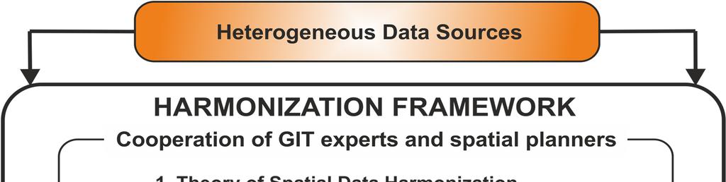
2 The SDI-EDU project The SDI-EDU project aims: to transfer experience from EU research projects dealing with Spatial Data Infrastructure (SDI) and spatial planning like PLAN4ALL, HUMBOLDT or NATURNET REDIME towards spatial planners in European Regions and municipalities the SDI-EDU educational curriculum is based upon this experience and user requirements to build European educational geoportal for spatial planning the content material will be accessible on this geoportal
3 Target groups The targeted end users specialized, but ordinary public active in planning processes have to fully understand the meaning and consequences of INSPIRE. In our focus are both: the national level stakeholders (ministries, planning institutes, leading planning ateliers), and the regional administrations and urban planners.


4 Educational curriculum user requirements
5 Educational curriculum Political consequences of INSPIRE on local and regional level (in relation to spatial planning) INSPIRE requirements from the technological point of view The examples of solutions for SDI building (commercial x open source) INSPIRE, Metadata & spatial planning INSPIRE, Spatial data & spatial planning INSPIRE Networking architecture Intellectual property rights & Spatial data infrastructures Monitoring obligation + Practical examples (how to)
6 State of the art Overall we have 17 lessons English content is almost ready In nowadays the translation is running Content reviewer: Institute for Spatial Development under the Czech Ministry of Regional Development GET INVOLVED write to:


7 SDI-EDU Educational geoportal
8 Example of the lesson about spatial data harmonization

9 Harmonization and its role in spatial planning
10 Spatial data harmonization Providing access to data through network services in a representation that allows for combining it with other INSPIRE data in a coherent way by using within the European Spatial Data Infrastructure (ESDI) a common set of data product specifications. This includes agreements about coordinate reference systems, classification systems, application schemes, etc. 10


11 Spatial data harmonization 11
12 Spatial data harmonization Components of harmonization: INSPIRE principles Reference model Data translation model Portrayal model Application schemes and feature catalogues Dictionaries Metadata Maintenance Quality Data transfer Derived reporting & multiple representations Consistency between data Data Capturing 12
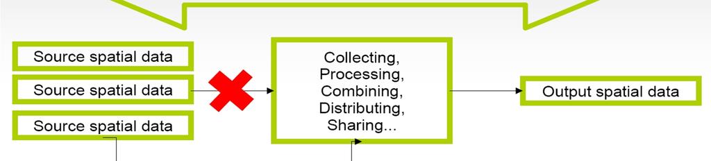
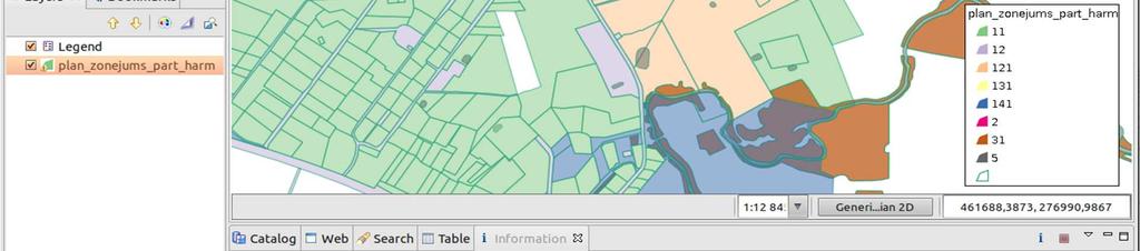
13 An example of Spatial Data Harmonization using PostgreSQL + PostGIS 13
14 HARMONIZATION Source data model Target data model Zemgale urban planing (specific data model) CORINE land cover Geometry Reclassification HARMONIZATION 14
15 HARMONIZATION STEPS Definition of reclassification rules Data reclassification Union of touching geometries in same class Transformation from multipolygon to polygons 15

16 HARMONIZATION STEPS IN Definition of reclassification rules Create mapping table Data reclassification SQL JOIN using mapping table Union of touching geometries in same class Spatial aggregate function Union Transformation from multipolygon to polygons Spatial function dump for converting multipolygon to polygon 16
17 ZEMGALE DATA MODEL Atribute Field Explanation Type VEIDS Planed land use type (see possible values down) Text 50 INDEKSS Area with speciffic restrictions Text 10 PLATIBA Area(m2) Long Integer TER_VIEN territorial unit Text 50 ADM_TER administrative area Text 50 LAYER Layer number in CAD systems Text 50 PIEZIMES notes Text


18 LAND COVER DATA MODEL CORINE land cover 18
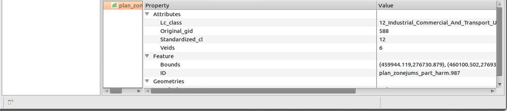
19 RECLASSIFICATION RULES ZEMGALE CLASSIFICATION CORINE NOMENCLATURE 1 DzM Low-rise residential dwellings 11 Urban fabric 2 DzV Multi-residential dwellings 11 Urban fabric 3 P Public Building 11 Urban fabric 4 RR Production facilities and warehouses 121 Industrial or commercial units 5 RD Mining area 131 Mineral extraction sites 6 T Technical Building 12 Industrial, commercial... 7 Ū Waters 5 Water bodies 8 M Forests 31 Forests 9 ZĪ Outstanding foliage sites No corresponding class 10 ZC Other groomed greenery space 141 Green urban areas 11 L Rural Land 2 Agriculture areas 12 No data No corresponding class 19
20 Database tables plan_zonejums_part orginal dataset (imported from shapefile) lc_original - original classification for land cover lc_standardized standardized classification for land cover standardized_to_original classification mapping plan_zonejums_part_harm reclassified data 20

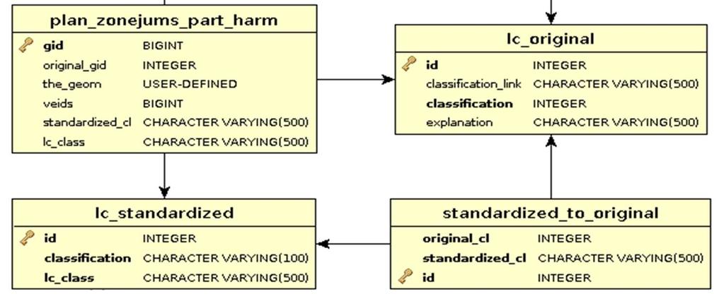
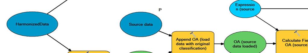
21 Database schema 21
22 Harmonization query We have: plan_zonejums_part, lc_original, lc_standardized, standardized_to_original We need: plan_zonejums_part_harm SQL Query: CREATE TABLE plan_zonejums_part_harm AS SELECT nextval('gid_seq'::regclass) AS gid, orig.gid AS original_gid, orig.the_geom, orig.veids, orig.standardized_cl, lc_standardized.lc_class FROM lc_standardized, ( SELECT plan_zonejums_part.gid, plan_zonejums_part.the_geom, plan_zonejums_part.veids, standardized_to_original.standardized_cl FROM plan_zonejums_part RIGHT JOIN standardized_to_original ON plan_zonejums_part.veids = standardized_to_original.original_cl) orig WHERE orig.standardized_cl::text = lc_standardized.classification::text; 22
23 Database tables plan_zonejums_part orginal dataset (imported from shapefile) lc_original original classification for land cover lc_standardized standardized classification for land cover standardized_to_original classification mapping plan_zonejums_part_harm reclassified data 23
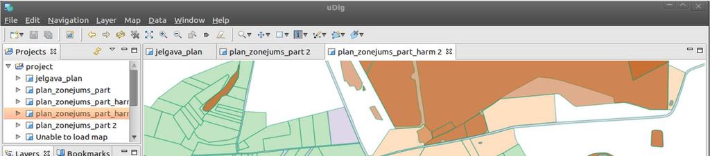
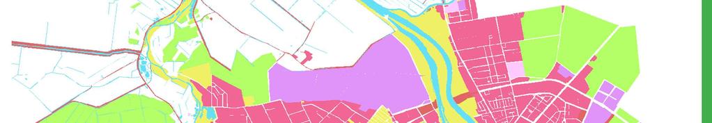
24 RECLASSIFIED DATA SET 24
25 Next step union of adjacent features with same class SELECT NEXTVAL('gid_seq'::regclass)::integer AS gid, (ST_Dump(foo.the_geom)).geom AS the_geom, standardized_cl, lc_class FROM ( SELECT ST_union(the_geom) AS the_geom, standardized_cl, lc_class FROM plan_zonejums_part_harm WHERE the_geom IS NOT NULL GROUP BY standardized_cl, lc_class) AS foo WHERE foo.the_geom IS NOT NULL; 25

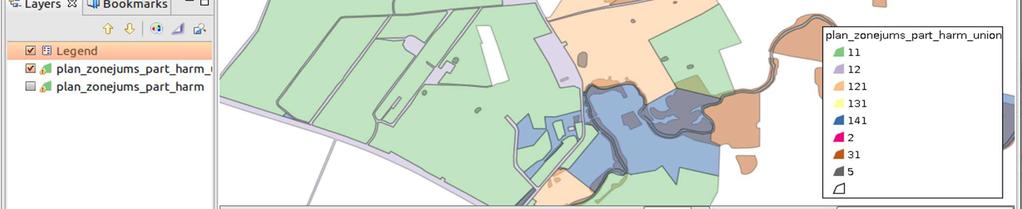
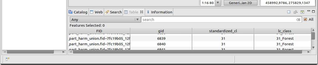
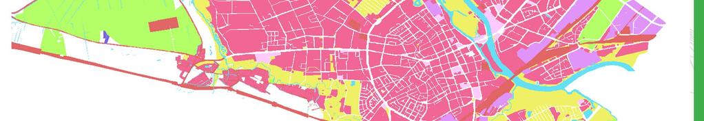
26 Final dataset 26
27 An example of Spatial Data Harmonization using commercial GIS software - ArcGIS 27
28 Using ArcGIS Model Builder for transformations between data models - PLAN4ALL Land Cover example 28


29 Understanding target data Plan4all Land Cover data model 29
30 Understanding target data Plan4all Land Cover data model ERA diagram of database schema in ESRI Geodatabase. 30
31 Understanding target data Plan4all Land Cover data model 31
32 Understanding source data Zemgale (Latvia) data model Atribute Field Explanation Type VEIDS Planed land use type (see possible values down) Text 50 INDEKSS Area with speciffic restrictions Text 10 PLATIBA Area(m2) Long Integer TER_VIEN territorial unit Text 50 ADM_TER administrative area Text 50 LAYER Layer number in CAD systems Text 50 PIEZIMES notes Text
33 Attribute mapping ZEMGALE CLASSIFICATION CORINE NOMENCLATURE 1 DzM Low-rise residential dwellings 11 Urban fabric 2 DzV Multi-residential dwellings 11 Urban fabric 3 P Public Building 11 Urban fabric 4 RR Production facilities and warehouses 121 Industrial or commercial units 5 RD Mining area 131 Mineral extraction sites 6 T Technical Building 12 Industrial, commercial... 7 Ū Waters 5 Water bodies 8 M Forests 31 Forests 9 ZĪ Outstanding foliage sites No corresponding class 10 ZC Other groomed greenery space 141 Green urban areas 11 L Rural Land 2 Agriculture areas 12 No data No corresponding class 33
34 Transformation steps Understanding both source and target data A necessary condition! 1. Transform source data to WGS Transform the source data geometry and attributes to match the target scheme. 3. Apply domain. 34

35 Transformation of coordinate system 1. Transform source data to WGS 84. Explore source coordinate system, Run transformation 35
36 Transformation of geometry and attributes 2. Transform the source data geometry and attributes to match the target scheme. Create classes: LandCoverOriginalArea, LandCoverStandardisedArea. Fill them with data. Create relationship between them. 36

37 Transformation of geometry and attributes 37


38 Applying a domain 3. Apply a StandardClassification domain to LandCoverStandardisedArea. 38

39 Result 39
40 Thank you for your attention! Karel Janecka Faculty of Applied Sciences, University of West Bohemia Pilsen, Czech Republic
Tomas Mildorf, Karel Janecka University of West Bohemia in Pilsen Czech Republic
 European Network of Best Practices for Interoperability of Spatial Planning Information Tomas Mildorf, Karel Janecka mildorf@centrum.cz, kjanecka@kma.zcu.cz University of West Bohemia in Pilsen Czech Republic
Plan4all (econtentplus project)
") Plan4all (econtentplus project) Karel CHARVAT 1, Tomáš MILDORF 2 1 Help service remote sensing, Ltd., Černoleská 1600, 256 01 Benešov u Prahy, Czech Republic charvat@bnhelp.cz 2 Department of Mathematics
Plan4all (econtentplus project) Karel CHARVAT 1, Tomáš MILDORF 2 1 Help service remote sensing, Ltd., Černoleská 1600, 256 01 Benešov u Prahy, Czech Republic charvat@bnhelp.cz 2 Department of Mathematics
Interoperability of Spatial Planning Data
 INSPIRE Conference 2010, Krakow, Poland Interoperability of Spatial Planning Data European Network of Best Practices for Interoperability of Spatial Planning Information Tomas Mildorf mildorf@centrum.cz
reviewed paper Information Around Us: Questions Connected to Information and Data Heterogeneities in Planning Activities Otakar Cerba
 reviewed paper Information Around Us: Questions Connected to Information and Data Heterogeneities in Planning Activities Otakar Cerba (Ing. et Mgr. Otakar Cerba, Ph.D, University of West Bohemia, Univerzitni
Urban Planning in the Czech Republic & Humboldt project Otakar ČERBA, Karel CHARVÁT, Štěpán KAFKA
 (Ing. Et Mgr. Otakar ČERBA, Department of Mathematics, Faculty of Applied Sciences, University of West Bohemia in Pilsen, Univerzitní 22, 306 14 Plzen, Czech Republic, ota.cerba@seznam.cz) (RNDr. Karel
SDI-Challenges European perspective
 THE HIGH LEVEL FORUM ON GLOBAL GEOSPATIAL INFORMATION MANAGEMENT Seoul, Republic of Korea, 24-26 October 2011 Session 1: Challenges in geospatial policy formation and institutional arrangements SDI-Challenges
Model Generalisation in the Context of National Infrastructure for Spatial Information
 Model Generalisation in the Context of National Infrastructure for Spatial Information Tomas MILDORF and Vaclav CADA, Czech Republic Key words: NSDI, INSPIRE, model generalization, cadastre, spatial planning
Harmonisation of Spatial Planning Data
 INSPIRE Conference 18 June 2011 Edinburgh, Great Britain Harmonisation of Spatial Planning Data Tomas Mildorf University of West Bohemia mildorf@centrum.cz Pilsen, Czech Republic Co-funded by the Community
Implementation of INSPIRE Principles: Sardinia Region SDI State of the Art and Further Developments
 REGION OF SARDINIA (ITALY) LOCAL AUTHORITY FOR MUNICIPALITIES, FINANCES AND URBAN PLANNING DEPT. FOR THE REGIONAL SPATIAL DATA INFRASTRUCTURE Implementation of INSPIRE Principles: Sardinia Region SDI State
INSPIRE Implementation in Estonia using ArcGIS
 INSPIRE Implementation in Estonia using ArcGIS Sulev Õitspuu Head of Bureau of Geoinfosystems Estonian Land Board 26.09.2016 Population: 1,3 million (69% Estonians) Area: 45,339 km 2 15 counties Estonia
Newsletter. Nr. 5 / June Special Issue HLanData Pilot Projects
 Nr. 5 / June 2012 Newsletter Special Issue HLanData Pilot Projects Pilot 1: Land Use and Land Cover Data Analysis System for Intermediate-Level Users The main objective of PILOT 1 is to demonstrate the
INSPIRATION results and benefits for the Agency for Real Estate Cadastre
 JOINT RESEARCH CENTER - E&I WORKSHOP INSPIRATION results and benefits for the Agency for Real Estate Cadastre Sonja Dimova, state advisor AGENCY FOR REAL ESTATE CADASTRE REPUBLIC OF MACEDONIA Wednesday,
The state-of-the-art of the Finnish SDI. Arctic SDI WG Meeting
 The state-of-the-art of the Finnish SDI Arctic SDI WG Meeting Moscow 8.9.2011 Esa Tiainen Development Centre 1 NATIONAL LAND SURVEY DOWN TO EARTH Contents Legal framework Coordination structure Network
Some practices of Geospatial coding and referencing statistics in Finland and in Europe
 Some practices of Geospatial coding and referencing statistics in Finland and in Europe Marja Tammilehto-Luode UN Expert Group on the Integration of Statistical and Geospatial Information 30.10. 1.11.2013
Solving the European Data Puzzle Simplifying INSPIRE Challenges and Usage. con terra GmbH Dipl.-Ing. Mark Döring
 Solving the European Data Puzzle Simplifying INSPIRE Challenges and Usage con terra GmbH Dipl.-Ing. Mark Döring INSPIRE Reference Projects GeoBAK 2.0 Project // INSPIRE Data & Services The Project Evolution
Tomas Mildorf New technologies for the information society University of west bohemia in pilsen, Czech republic
 Tomas Mildorf New technologies for the information society University of west bohemia in pilsen, Czech republic Karel Charvat Help Service Remote Sensing, Czech republic AIP-7 GEOSS, 20 MAY 2014 By 2015,
State of the Art. in Spatial Planning Data Harmonisation & Spatial Data Infrastructure (SDI) Julia Neuschmid, CEIT ALANOVA
 Julia Neuschmid, CEIT ALANOVA") INSPIRE Conference, June 2010, Krakow State of the Art in Spatial Planning Data Harmonisation & Spatial Data Infrastructure (SDI) Julia Neuschmid, CEIT ALANOVA Co-funded by the Community programme econtentplus
INSPIRE Conference, June 2010, Krakow State of the Art in Spatial Planning Data Harmonisation & Spatial Data Infrastructure (SDI) Julia Neuschmid, CEIT ALANOVA Co-funded by the Community programme econtentplus
Status of implementation of the INSPIRE Directive 2016 Country Fiches. COUNTRY FICHE Estonia
 Status of implementation of the INSPIRE Directive 2016 Country Fiches COUNTRY FICHE Estonia Introduction... 1 1. State of Play... 2 1.1 Coordination... 2 1.2 Functioning and coordination of the infrastructure...
The Process of Spatial Data Harmonization in Italy. Geom. Paola Ronzino
 The Process of Spatial Data Harmonization in Italy Geom. Paola Ronzino ISSUES Geospatial Information in Europe: lack of data harmonization the lack of data duplication of data CHALLENGES Challenge of INSPIRE:
INSPIRE - A Legal framework for environmental and land administration data in Europe
 INSPIRE - A Legal framework for environmental and land administration data in Europe Dr. Markus Seifert Bavarian Administration for Surveying and Cadastre Head of the SDI Office Bavaria Delegate of Germany
Regione Umbria. ESRI EMEA User Conference 2010 Rome, October 27th 2010
 Direzione Ambiente, Territorio e Infrastrutture Servizio Informatico/Informativo: geografico, ambientale e territoriale ESRI EMEA User Conference 2010 Rome, October 27th 2010 Arch. Ambra Ciarapica, Dott.
Evaluating Sustainability of the Georesources Observation System
 Evaluating Sustainability of the Georesources Observation System Michael Mente Federal Institute for Geosciences and Natural Resources Germany, Hannover GEOSS-CBC Meeting Athens April 27th 28th, 2009 GEOSS-CBC
Project based approach developing National Spatial Data Infrastructure in Lithuania
 Project based approach developing National Spatial Data Infrastructure in Lithuania National Land Service under the Ministry of Agriculture of The Republic of Lithuania Cadastres & Geodesy Department Director
INSPIRing Geospatial Framework For Local Administrations
 This project is financed by the European Union and the Republic of Turkey Presented at the FIG Congress 2018, May 6-11, 2018 in Istanbul, Turkey National Programme for Turkey 2010 Instrument for Pre-Accession
SITR-IDT The Spatial Data Infrastructure of Sardinia Region
 ITALY LOCAL AUTHORITY FOR MUNICIPALITIES, FINANCES AND URBAN PLANNING REGIONAL DEPARTMENT FOR CARTOGRAPHY AND INFORMATION SYSTEMS SITR-IDT The Spatial Data Infrastructure of Sardinia Region Content of
Project EuroGeoNames (EGN) Results of the econtentplus-funded period *
 Results of the econtentplus-funded period *") UNITED NATIONS Working Paper GROUP OF EXPERTS ON No. 33 GEOGRAPHICAL NAMES Twenty-fifth session Nairobi, 5 12 May 2009 Item 10 of the provisional agenda Activities relating to the Working Group on Toponymic
UNITED NATIONS Working Paper GROUP OF EXPERTS ON No. 33 GEOGRAPHICAL NAMES Twenty-fifth session Nairobi, 5 12 May 2009 Item 10 of the provisional agenda Activities relating to the Working Group on Toponymic
NAG-City Expert Workshop Oslo 8-9. October 2012 SOSI standards and mapping for Europe (INSPIRE)
") NAG-City Expert Workshop Oslo 8-9. October 2012 SOSI standards and mapping for Europe (INSPIRE) Per Ryghaug, Geomatics The Norwegian national standard on geographic information - SOSI Started in 1984 NGU
NAG-City Expert Workshop Oslo 8-9. October 2012 SOSI standards and mapping for Europe (INSPIRE) Per Ryghaug, Geomatics The Norwegian national standard on geographic information - SOSI Started in 1984 NGU
Gistat: moving towards a location information management system
 Gistat: moving towards a location information management system (merging geographical, statistical and historical information) Pina Grazia Ticca Marco Ballin Istat - Italy Aguascalientes, Mexico 2-4 December
Land Cover Data Processing Land cover data source Description and documentation Download Use Use
 Land Cover Data Processing This document provides a step by step procedure on how to build the land cover data required by EnSim. The steps provided here my be long and there may be short cuts (like using
Ready for INSPIRE.... connecting worlds. European SDI Service Center
 Ready for INSPIRE Consultancy SOFTWARE T r a i n i n g Solutions... connecting worlds European SDI Service Center Increasing Added Value with INSPIRE and SDI Components INSPIRE In 2007, the European Commission
I&CLC2000 in support to new policy initiatives (INSPIRE, GMES,..)
") I&CLC2000 in support to new policy initiatives (INSPIRE, GMES,..) Manfred Grasserbauer, Director Joint Research Centre Institute for Environment and Sustainability 1 IMAGE 2000 European mosaic of satellite
I&CLC2000 in support to new policy initiatives (INSPIRE, GMES,..) Manfred Grasserbauer, Director Joint Research Centre Institute for Environment and Sustainability 1 IMAGE 2000 European mosaic of satellite
Emerging Trends in Institutional Arrangements Europe - Finland
 Emerging Trends in Institutional Arrangements Europe - Finland Arvo Kokkonen Deputy Director General National Land Survey of Finland 1 Contents Facts about Finland National Land Survey of Finland European
INSPIRE implementation in the Turkish Ministry of Environment and Urbanization Producing and Publishing Environmental Data
 INSPIRE implementation in the Turkish Ministry of Environment and Urbanization Producing and Publishing Environmental Data Ezgi Sarmusak Urban Planner, MoEU Sibel Süer Toybıyık - Assistant Expert, MoEU
SpatialKit and SEXTANTE
 Free & Open Source Extensions SpatialKit and SEXTANTE for ArcGIS Desktop 9 and 10 Karsten Vennemann, Terra GIS Ltd. www.terragis.net Seattle, WA, USA karsten@terragis.net 206 905 1711 Talk Overview SpatialKit
A. Boluwade 1 and A Ferdinand. Ste Anne de Bellevue, QC, H9X 3V9, Canada. ABSTRACT
 The Design and Development of Spatial Database Management Systems (SDMS) for Hydrographic Studies using coupled Open-Source GIS and Relational Database A. Boluwade 1 and A Ferdinand 1 Department Bioresource
SITMUN: Cooperating to Build Local SDIs in the Barcelona Region
 SITMUN: Cooperating to Build Local SDIs in the Barcelona Region Diputació de Barcelona Territory and Sustainability Area Territorial Information Systems Department INSPIRE CONFERENCE Barcelona, September
The Infrastructure for Spatial Information in the European Community vs. regional SDI: the shortest way for reaching economic and social development
 The Infrastructure for Spatial Information in the European Community vs. regional SDI: the shortest way for reaching economic and social development Mauro Salvemini EUROGI PRESIDENT Professor at Sapienza
EEOS 381 -Spatial Databases and GIS Applications
 EEOS 381 -Spatial Databases and GIS Applications Lecture 5 Geodatabases What is a Geodatabase? Geographic Database ESRI-coined term A standard RDBMS that stores and manages geographic data A modern object-relational
Techniques for Science Teachers: Using GIS in Science Classrooms.
 Techniques for Science Teachers: Using GIS in Science Classrooms. After ESRI, 2008 GIS A Geographic Information System A collection of computer hardware, software, and geographic data used together for
IDEBarcelona: Cooperating for a Smart Region Infrastructure
 IDEBarcelona: Cooperating for a Smart Region Infrastructure Marta Codinachs Serra Diputació de Barcelona Territory and Sustainability Area Territorial Information Systems Department SMART CITY EXPO WORLD
GIS Level 2. MIT GIS Services
 GIS Level 2 MIT GIS Services http://libraries.mit.edu/gis Email: gishelp@mit.edu TOOLS IN THIS WORKSHOP - Definition Queries - Create a new field in the attribute table - Field Calculator - Add XY Data
SDI Standards at work
 SDI Standards at work Jan Juul Jensen Senior Technology Strategist Informi GIS Denmark Informi GIS Private held Limited Company Specialized in GIS 100+ employees HQ in Charlottenlund, Copenhagen Regional
Pal NIKOLLI Bashkim IDRIZI Ismail KABASHI Adelajda HALILI THE IMPLEMENTATION OF NATIONAL SPATIAL DATA INFRASTRUCTURE IN ALBANIA
 Pal NIKOLLI Bashkim IDRIZI Ismail KABASHI Adelajda HALILI THE IMPLEMENTATION OF NATIONAL SPATIAL DATA INFRASTRUCTURE IN ALBANIA Overview: Goals of paper Some definitions of SDI NSDI Development NSDI in
Geocoding of Statistics Portugal Business Register and it s integration with the INSPIRE s Annex III Buildings theme
 Geocoding of Statistics Portugal Business Register and it s integration with the INSPIRE s Annex III Buildings theme Barcelona, 26th September2016 INE/DMSI-GEO» 1 The summary Business Register (BR) Enterprise
ArcGIS 10.4 for INSPIRE Server Extension Customization Guide on INSPIRE View Service Layer Content
 ArcGIS 10.4 for INSPIRE Server Extension Customization Guide on INSPIRE View Service Layer Content 1 Introduction... 1 2 Introduction to LayerInfo Table... 1 2.1 Purpose... 1 2.2 Table Structure Explained...
Ministry of ICT of I.R.IRAN
 The ECO 8/6 mill km 2 10 Slamic countries ~330 mill people Oil, Gas, Industries,Tourism 2 Issue transformation in last decade Problem solving needs more integrated approach More interaction &complexity
Roadmap to interoperability of geoinformation
 Roadmap to interoperability of geoinformation and services in Europe Paul Smits, Alessandro Annoni European Commission Joint Research Centre Institute for Environment and Sustainability paul.smits@jrc.it
Spatial information for urban planning and management case study Zagreb Darko ŠIŠKO, Vlado CETL, Tomislav CICELI. Strasbourg, September 7th, 2017
 Spatial information for urban planning and management case study Zagreb Darko ŠIŠKO, Vlado CETL, Tomislav CICELI Strasbourg, September 7th, 2017 Contents: Cities & INSPIRE Cities in Croatian NSDI City
Technical Framework Methodology as a core of building up the NSDI NSDI Implementation Specifics in Serbia
 Technical Framework Methodology as a core of building up the NSDI NSDI Implementation Specifics in Serbia Luka Jovičić SDI Consultant@ Gramont Ltd. Aleksandar Dedić RGA NSDI department Dragica Pajić RGA
Status of implementation of the INSPIRE Directive 2016 Country Fiches. COUNTRY FICHE Czech Republic
 Status of implementation of the INSPIRE Directive 2016 Country Fiches COUNTRY FICHE Czech Republic Introduction... 1 1. State of Play... 2 1.1 Coordination... 2 1.2 Functioning and coordination of the
INSPIREd solutions for Air Quality problems Alexander Kotsev
 INSPIREd solutions for Air Quality problems Alexander Kotsev www.jrc.ec.europa.eu Serving society Stimulating innovation Supporting legislation The European data puzzle The European data puzzle 24 official
INSPIRE Data Harmonization and Network Services at the German Federal Institute of Hydrology (BfG) Klaus Fretter BfG Sören Dupke con terra
 Klaus Fretter BfG Sören Dupke con terra") INSPIRE Data Harmonization and Network Services at the German Federal Institute of Hydrology (BfG) Klaus Fretter BfG Sören Dupke con terra Outline Introduction BfG Approach used > Matching > Mapping >
INSPIRE Data Harmonization and Network Services at the German Federal Institute of Hydrology (BfG) Klaus Fretter BfG Sören Dupke con terra Outline Introduction BfG Approach used > Matching > Mapping >
GIS Building Communities beyond National Borders (Building Successful Spatial Data Infrastructures) Nick Land, ESRI Europe
 Nick Land, ESRI Europe") GIS Building Communities beyond National Borders (Building Successful Spatial Data Infrastructures) Nick Land, ESRI Europe UK worst flooding in the last 60 years 350,000 households without drinking water
GIS Building Communities beyond National Borders (Building Successful Spatial Data Infrastructures) Nick Land, ESRI Europe UK worst flooding in the last 60 years 350,000 households without drinking water
Harmonizing spatial databases and services at local and regional level
 Harmonizing spatial databases and services at local and regional level A. Ionita 1, M. Caian 2, V. Vassilev 3, V. Craciunescu 2, I. Nedelcu 4 1 Research Institute for Artificial Intelligence, Bucuresti,
Data Aggregation with InfraWorks and ArcGIS for Visualization, Analysis, and Planning
 Data Aggregation with InfraWorks and ArcGIS for Visualization, Analysis, and Planning Stephen Brockwell President, Brockwell IT Consulting, Inc. Join the conversation #AU2017 KEYWORD Class Summary Silos
Global Geospatial Information Management Country Report Finland. Submitted by Director General Jarmo Ratia, National Land Survey
 Global Geospatial Information Management Country Report Finland Submitted by Director General Jarmo Ratia, National Land Survey Global Geospatial Information Management Country Report Finland Background
INSPIRE and Land Use Planning System in Portugal
 INSPIRE and Land Use Planning System in Portugal Rui Amaro Alves Director General Directorate General for Territorial Development ruialves@dgterritorio.pt Carlos Simões Senior Technician Directorate General
Proposal for a DIRECTIVE OF THE EUROPEAN PARLIAMENT AND OF THE COUNCIL. establishing an infrastructure for spatial information in the Community
 Proposal for a DIRECTIVE OF THE EUROPEAN PARLIAMENT AND OF THE COUNCIL establishing an infrastructure for spatial information in the Community INSPIRE http://inspire.jrc.it/ Alessandro Annoni 1 EU Commission
Spatial Data Infrastructures in Greece: State of play Spring 2003
 Spatial Data Infrastructures in : State of play Spring 2003 Country report on SDI elaborated in the context of a study commissioned by the EC (EUROSTAT & DGENV) in the framework of the INSPIRE initiative
Domain Land Use/Cover Data Model Enabling Multiple Use for Turkey
 Domain Land Use/Cover Data Model Enabling Multiple Use for Turkey Key words: Spatial Data Management, LULC, Land Use/Cover SUMMARY Land use/ land cover (LULC) information, one aspect of GI, has huge important
International Regulatory Conference , Ohrid
 Creating Efficiencies, Stimulating Growth International Regulatory Conference 2015 19.-20.5, Ohrid Single point for information Maja Kostoska / GIS Developer maja.kostoska@gdi.net Introduction (GDi) AEC
ArcGIS for INSPIRE. Paul Hardy. ArcGIS. ArcGIS for INSPIRE Enables Esri ArcGIS users to implement and comply with INSPIRE. INSPIRE Data Themes
 Enables Esri ArcGIS users to implement and comply with INSPIRE Paul Hardy phardy@esri.com EuroGeographics INSPIRE KEN (Schema Transformation) 8/9 October 2013, Marne la Vallée INSPIRE Data Themes Annex
CORINE LAND COVER CROATIA
 CORINE LAND COVER CROATIA INTRO Primary condition in making decisions directed to land cover and natural resources management is presence of knowledge and high quality information about biosphere and its
Zagreb Spatial Data Infrastructure. Sanja Batić, APIS IT Split, 14. rujna 2011.
 Zagreb Spatial Data Infrastructure Sanja Batić, APIS IT Split, 14. rujna 2011. Agenda Zagreb Spatial Data Infrastructure - ZIPP Guidelines for further ZIPP Geoportal development Conclusion 1964 The Centre
HARMONIZING AND INTEGRATING OF THREE LEVELS OF SPATIAL PLANNING DATABASES FOR THE MUNICIPALITY OF VITI IN KOSOVA
 Bashkim IDRIZI, Valbone SULEJMANI HARMONIZING AND INTEGRATING OF THREE LEVELS OF SPATIAL PLANNING DATABASES FOR THE MUNICIPALITY OF VITI IN KOSOVA 4-8 September 2017; Kehl and Strasbourg Overview: Preface
RESULTS OF DEVELOPMENT AND APPLICATION GEOGRAPHIC INFORMATION STANDARDS IN VIETNAM. Dr. Tran Bach Giang Vietnam
 RESULTS OF DEVELOPMENT AND APPLICATION GEOGRAPHIC INFORMATION STANDARDS IN VIETNAM Dr. Tran Bach Giang Vietnam Shibu lijack Contents 1. BACKGROUND 2. BASIC GEOGRAPHIC INFORMATION STANDARDS (BGIS) Background
CAPE FARM MAPPER - an integrated spatial portal
 CAPE FARM MAPPER - an integrated spatial portal Skukuza Dr Mike Wallace June 2017 Overview of GIS applications in WCDoA Spatial information and technology has become indispensable across a wide range of
Smart Points of Interest: Big, Linked and Harmonized Spatial Data
 Smart Points of Interest: Big, Linked and Harmonized Spatial Data Otakar Cerba and Tomas Mildorf ABSTRACT: The current trends in geomatics and geoinformatics are very often connected with three words big,
GENERATING INSPIRE PLU DATA ON BASE OF THE GERMAN NATIONAL STANDARD XPLANUNG. Dr. Joachim Benner Dr. Kai-Uwe Krause September
 GENERATING INSPIRE PLU DATA ON BASE OF THE GERMAN NATIONAL STANDARD XPLANUNG Dr. Joachim Benner Dr. Kai-Uwe Krause September Introduction city state Hamburg North Sea Hamburg Hamburg as a city state is
Land Use in the context of sustainable, smart and inclusive growth
 Land Use in the context of sustainable, smart and inclusive growth François Salgé Ministry of sustainable development France facilitator EUROGI vice president AFIGéO board member 1 Introduction e-content+
The Governance of Land Use
 The Governance of Land Use Country fact sheet Czech Republic The planning system Levels of government and their responsibilities The Czech Republic is a unitary state with 3 levels of government: the national
Norwegian spatial data infrastructure supporting disaster risk management Norwegian Mapping Authority
 Norwegian spatial data infrastructure supporting disaster risk management Norwegian Mapping Authority Arvid Lillethun, Norwegian Mapping Authority Land and Poverty 2018 Conference, World Bank 19.-23. March
Sustainable and Harmonised Development for Smart Cities The Role of Geospatial Reference Data. Peter Creuzer
 Sustainable and Harmonised Development for Smart Cities The Role of Geospatial Reference Data Peter Creuzer 1. Introduction - Smart Cities and Geodata 2. Geodata in Germany 3. Examples 4. Data and Service
POSSIBILITY FOR APPLICATION OF GIS TECHNOLOGIES IN RTB BOR GROUP
 MINING AND METALLURGY INSTITUTE BOR UDK: 622 ISSN: 2334-8836 (Štampano izdanje) ISSN: 2406-1395 (Online) UDK: 681.33:622.343(045)=111 doi:10.5937/mmeb1603021v Nenad Vušović *, Marko Vuković **, Igor Svrkota
Between legislation and consensus how do we INSPIRE Denmark?
 Between legislation and consensus how do we INSPIRE Denmark? Olav Eggers Spatial Data Infrastructure Division Danish Ministry of the Environment National Survey and Cadastre (KMS), Denmark INSPIRE Contact
INSPIRE Land Cover and Land Use Data Specifications
 INSPIRE Land Cover and Land Use Data Specifications Lena Hallin-Pihlatie Facilitator of the Land Cover and Land Use INSPIRE Thematic Cluster www.jrc.ec.europa.eu Serving society Stimulating innovation
ArcGIS for INSPIRE. Marten Hogeweg
 ArcGIS for INSPIRE Marten Hogeweg Please Take Our Survey on the App Download the Esri Events app and find your event Select the session you attended Scroll down to find the feedback section Complete answers
Tua Nylén and Harri Tolvanen. Deliverable D.T3.2.1 Guidelines for harmonising, producing and managing crossborder.
 Tua Nylén and Harri Tolvanen Deliverable D.T3.2.1 Guidelines for harmonising, producing and managing crossborder spatial data Cross-border case 28.7.2017 CONTENTS BACKGROUND... 2 FREQUENTLY USED TERMS...
ESBN. Working Group on INSPIRE
 ESBN Working Group on INSPIRE by Marc Van Liedekerke, Endre Dobos and Paul Smits behalf of the WG members WG participants Marc Van Liedekerke Panos Panagos Borut Vrščaj Ivana Kovacikova Erik Obersteiner
D.T2.2.2 Methodological model for an integrated monitoring system D.T METHODOLOGICAL MODEL FOR AN INTEGRATED MONITORING SYSTEM
 D.T.2.2.2. METHODOLOGICAL MODEL FOR AN INTEGRATED MONITORING SYSTEM PP7 SPECTRA 04 2018 1 1.1 1.2 1.3 INDEX FOREWORD p.7 CHAPTER 1 FIRST STAGE p.13 CHAPTER 2 DATA COLLECTING 2.1 Selection of the monitored
How GIS based Visualizations Support Land Use and Transportation Modeling
 How GIS based Visualizations Support Land Use and Transportation Modeling ESRI International Users Conference San Diego, CA - July 23, 2015 Prepared by: Troy Hightower Introduction This presentation will
An Introduction to the Community Maps Information Model
 Esri International User Conference July 23 27 San Diego Convention Center An Introduction to the Community Maps Information Model Seth Sarakaitis Agenda Overview of Community Maps Program Information Models
ISO Canadian Drought Monitor Data Product Specifications
 ISO 19131 Canadian Drought Monitor Data Product Specifications Revision: A Page 1 of 14 Data product specifications: Canadian Drought Monitor - Table of Contents- 1. Overview... 3 1.1. Informal description...
How local communities could profit from Habitats infrastructure
 Social Validation of INSPIRE Annex III Data Structures in EU Habitats How local communities could profit from Habitats infrastructure Andrea Scianna ( Icar CNR Italy ) consultant for Madonie Park Authority
Evolution and development of National Spatial Data Infrastructure in Republic of Moldova
 Agency for Land Relations and Cadastre of the Republic of Moldova Evolution and development of National Spatial Data Infrastructure in Republic of Moldova Alexandru Morcov Deputy general director ALRC
McGill University, Ste Anne de Bellevue, QC, H9X 3V9, Canada. 2 University of Juame I, Castellon, Spain.
 The Design and Development of Spatial Database Management Systems (SDMS) for Hydrographic Studies using Coupled Open-Source GIS and Relational Database. Alaba Boluwade, M.Sc. *1 and Andrew Ferdinand M.Sc.
Land Accounts - The Canadian Experience
 Land Accounts - The Canadian Experience Development of a Geospatial database to measure the effect of human activity on the environment Who is doing Land Accounts Statistics Canada (national) Component
INSPIRE Shared Service
 INSPIRE Shared Service Creation and operation out of the box Petra Fritz (HZD), Michael Voigtländer (Esri Deutschland GmbH) INSPIRE Shared Service Agenda HZD backbone for a geodata infrastructure Implementing
Esri and GIS Education
 Esri and GIS Education Organizations Esri Users 1,200 National Government Agencies 11,500 States & Regional Agencies 30,800 Cities & Local Governments 32,000 Businesses 8,500 Utilities 12,600 NGOs 11,000
Urban-Rural spatial classification of Finland
 Urban-Rural spatial classification of Finland Finnish Environment Institute SYKE The geographical information-based area classification system has been created by the Finnish Environment Institute and
Implementing INSPIRE Geoportal in Turkey
 Implementing INSPIRE Geoportal in Turkey Gencay SERTER City and Regional Planner 1 Presentation Plan Introduction INSPIRE and Turkey Importance of al Spatial Planning Portal Logical&Legal Hierarchy GeoPortal
Indsæt billede her. Location an INSPIRED gateway to E-government
 Location an INSPIRED gateway to E-government Indsæt billede her Ulla Kronborg Mazzoli INSPIRE contact point Deputy Chief Spatial Data Infrastructure Danish National Survey and Cadastre Outline A short
Figure 1: The Centrope Region. Source: April 2010.
 CentropeMAP and CentropeSTATISTICS Cross-Border Geodata Infrastructure with User-Defined Thematic Maps Clemens Beyer, Walter Pozarek, Manfred Schrenk (Dipl.-Ing. Clemens Beyer, CEIT ALANOVA gemeinnützige
Implementing strategy for the Infrastructure for Spatial Information in Europe - INSPIRE Paul Smits
 Implementing strategy for the Infrastructure for Spatial Information in Europe - INSPIRE Paul Smits European Commission DG Joint Research Centre Institute for Environment and Sustainability Ispra, Italy
TWG BU State of Play November 2010
 TWG BU State of Play November 2010 TWG BU members General methodology Existing data Use cases User requirements Existing standards Modelling approach Next steps Plan of presentation TWG BU members TWG
Overview. Everywhere. Over everything.
 Cadenza Desktop Cadenza Web Cadenza Mobile Cadenza Overview. Everywhere. Over everything. The ultimate GIS and reporting suite. Provide, analyze and report data efficiently. For desktop, web and mobile.
One platform for desktop, web and mobile
 One platform for desktop, web and mobile Search and filter Get access to all data thematically filter data in context factually and spatially as well as display it dynamically. Export a selection or send
Experiences and Directions in National Portals"
 FIG Seminar on e-land Administration Innsbruck/Austria 2-4 June 2004 "ESRI's Experiences and Directions in National Portals" Kevin Daugherty Cadastral/Land Records Manager ESRI Topic Points Technology
Estonian approach to implementation of INSPIRE directive. Sulev Õitspuu Head of Bureau of Geoinfosystems Estonian Land Board
 Estonian approach to implementation of INSPIRE directive Sulev Õitspuu Head of Bureau of Geoinfosystems Estonian Land Board 13.06.2016 Contents - INSPIRE coordination in Estonia - INSPIRE implementation
HARMO-DATA Project Cross border spatial data harmonization using INSPIRE model
 HARMO-DATA Project Cross border spatial data harmonization using INSPIRE model Blaž Barborič, Raffaela Cefalo, Alessandra Chiarandini, Silvano Dezorzi, Tomaž Petek, Martin Puhar, Mauro Zanardo, Tatiana