INTEGRATED NORTH ANDEAN MAP (MIAN) Technical Specifications
|
|
|
- Sophia Shelton
- 5 years ago
- Views:
Transcription
")


1 INTEGRATED NORTH ANDEAN MAP (MIAN) Technical Specifications Consulting and Technical Coordination With special contributions from the United States National Section of the PAIGH
2 Specifications of the Integrated North Andean Map (MIAN) Title Specifications of the Integrated North Andean Map (MIAN) Identifier Author MIAN Specifications MIAN Project work team Date Theme Objective Data product specifications according to the ISO19131:2007 standard. Describe, in a standardized way, the Integrated North Andean Map. Contributions Edson Salinas (IGM BO), Percy Valverde (IGM BO), Vianey A. Muñoz (IGAC CO), Amadeo Fajardo (IGAC CO), Paulina Guerrón (IGM EC), Eliana Tene (IGM EC), Elizabeth Samuels (IGNTG PA), Ariel Agrazal (IGNTG PA), Reynado Flores (IGN PE), Wilman G. Avilés (IGN PE), Roberto Lugo (USGS USA), Antonio F. Rodríguez (CNIG ES), Luis Miguel Blanco (CNIG ES) Distribution Public Related Documents ISO 19131:2007 Geographic Information Data Product Specifications
3 Versions: Version number Date Author/modified by Comments A. F. Rodríguez Creation of the outline structure of the document A. F. Rodríguez Creation of a first draft Edson Salinas, Percy Valverde, Vianey A. Munoz, Amadeo Fajardo, Paulina Guerron, Eliana Tene, Elizabeth Samuels, Ariel Agrazal, Reynaldo Flores, Wilman G. Aviles, Roberto Lugo, Antonio F. Rodríguez, Luis Miguel Blanco Santiago Borrero Rodrigo Barriga Checks and comments
4 Content of the Specifications 1. Introduction to the product 2. Field of application 3. Identification of the product 4. Structure and content 5. Reference systems 6. Data Quality 7. Data Capture 8. Maintenance 9. Portrayal 10. Distribution 11. Metadata 12. Additional Information 13. Abbreviations and acronyms 14. References
5 1. Introduction to the product These technical specifications have been drafted in accordance with the ISO 19131:2007 standard Geographic Information Data Product Specifications. The Integrated North Andean Map (MIAN) is a geographic dataset covering the countries of Bolivia, Colombia, Ecuador, Panama and Peru with official, digital, standardized, continuous and fundamental (or reference) data in vector structure at 1: 250,000 resolution. It contains six themes (Administrative boundaries, Hydrography, Populated sites, Transport networks, Terrain Morphology and Miscellaneous) that in turn contain 15 geographic objects as indicated in Table 1. The full description of these is included in the «Catálogo de objetos geográficos MIAN» (MIAN Catalogue of geographic objects). It should be noted that the boundaries included in the geographic object «País» (country) are there as an approximate reference and for guidance; they do not have any official nor probative validity, in accordance with Chapter I, article 1 of the Organic Statute of the PAIGH. The aim of the MIAN is to provide a fundamental cartography for all kinds of users and all types of applications. It covers the spatial extent of the five countries mentioned above, but it is intended first of all to complement and give continuity to the Integrated Central America Map. Secondly, it is also intended to constitute, once Brazil and the rest of the countries of the subcontinent join, an Integrated Map of South America (MIAS). As a general philosophy, the MIAN has been developed always keeping the family of ISO standards as a reference and always seeking to be in compliance with the applicable standards. The OGC standards have also been taken into account, especially when considering the publication of the MIAN through Web Map Services and possibly WMTS. From the beginning, the MIAN will be available in the form of a WMS service at the GeoSUR geoportal under a CC BY 4.0 licence in this mode: CC BY 4.0 CAF, PAIGH, GeoSUR Program, IGM Bolivia, IGAC Colombia, IGM Ecuador, IGNTG Panama, IGN Peru The sources of the data used has been the official digital cartography closest to a resolution of 1:250,000 that the geographic institutes of the region have produced. These have been checked for errors and handled so as to form a continual digital map. The MIAN has been put together under the auspices of the CAF, the PAIGH and the GeoSUR Program, and has had available the technical support of the USGS of the Unites States and of the CNIG of Spain. This has been a model project in terms of the institutional cooperation, because the IGM of Bolivia, the IGAC of Colombia, the IGM of Ecuador, the IGNTG of Panama and the IGN of
6 Peru have participated in the production process, in a very positive team-based working environment. Work has been carried out jointly at five workshops: First Workshop (Bogota, 9th 13th of February, 2015), at which the team was set up, the project was defined and work was begun. Intermediate Workshop (Lima, 7th 8th of April, 2015), to incorporate the IGM of Bolivia, which had not been able to attend the First Workshop. Second Workshop (Quito, 13th 17th of July, 2015), which was for making progress in the work and achieving the first project milestones. Third Workshop (Panama, 16th 20th of November, 2015), dedicated to finalizing the data and metadata necessary for publishing a WMS server. Fourth Workshop (Rio de Janeiro, 16th 20th of May, 2016), for starting work on the continuous transition towards Brazil, settling the remaining details and defining the future evolution of the project. During the intervals between the workshops, work has proceeded by means of telephone conferences, electronic mail and the exchange of data and metadata files. 2. Field of application The MIAN covers the land area under the sovereignty of these countries: Bolivia (BO), Colombia (CO), Ecuador (EC), Panama (PA) and Peru (PE). It includes the archipelago of the Galapagos Islands (Ecuador) and all the islands that can be shown at the 1:250,000 scale, both the maritime and riverine islands. The bounding box at the WGS84/SIRGAS coordinates for latitude and longitude that defines the zone is: 12º 30 N 57º 30 W 23º 00 S 83º 45 W 3. Identification of the product The name of the digital data product is «Mapa Integrado Andino del Norte» (Integrated North Andean Map) v1.0 and its acronym is «MIAN». Both terms
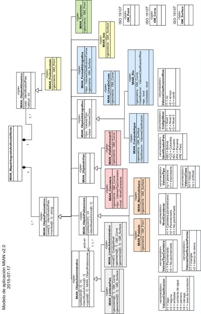
7 may be used in a generic way, without specifying the version or with a specific version. Examples: MIAN refers to the generic product and all that is said about it applies to all the versions. MIAN v1.0 refers only to the first version. The Integrated North Andean Map (MIAN) is a geographic dataset covering the countries of Bolivia, Colombia, Ecuador, Panama and Peru with official, digital, standardized, continuous and fundamental (or reference) data in vector structure at 1: 250,000 resolution. The purpose of the MIAN is to provide a fundamental cartography for all kinds of users and all types of applications. It covers the spatial extent of the five countries mentioned above, but it is intended first of all to complement and give continuity to the Integrated Map of Central America Map. Secondly, it is also intended to constitute, once Brazil and the rest of the countries of the subcontinent join, an Integrated Map of South America (MIAS). The thematic category of the MIAN data, in accordance with the classification of themes covered by the ISO 19115, standard is that of «imagerybasemapearthcover», code 010. As has already been mentioned, the MIAN covers the land area under the sovereignty of the countries of Bolivia (BO), Colombia (CO), Ecuador (EC), Panama (PA) and Peru (PE). The bounding box that defines the zone with WGS84 latitude and longitude coordinates is: 12º 30 N 57º 30 W 23º 00 S 83º 45 W The spatial portrayal is in vector structure and the spatial resolution is 1:250, Structure and content The language of the data is Spanish (esp) and the character set is the utf UML Model The UML v2.0 model can be seen in Figure 1; this covers the following geometric primitives in conformance with the ISO 19107:2003 standard: GM_Point GM_Curve GM_Surface
8
9 4.2 Catalogue of geographic objects Figure 1. MIAN v2.0 model The MIAN Catalogue is structured around 6 themes and 15 objects, just as is shown in Table 1: Table 1 Summary of the MIAN Catalogue Theme Administrative boundaries Hydrography Populated sites Transport networks Morphology Miscellaneous Geographic object Country, Level 1, Level 2 and Level 3 River, Coast line, Body of water, Hydrographic forms Settlement, Urbanized zone Railway, Road Spot height, Island Toponym It should be noted that the boundaries included in the geographic object «País» (country) are as a reference and for guidance; they do not have any official nor probative validity, in accordance with Chapter I, article 1 of the Organic Statute of the PAIGH [1]. The intention is not to portray the official boundaries of each country, rather it is to serve as a cartographic reference, lacking precision at large scales, so that the user can find the way spatially in an approximate manner. The full description of the themes, the geographic objects and the attributes that each one of those objects has, can be seen in Annex I. The MIAN v2016 catalogue of geographic objects is available in digital version at the GeoSUR Program geoportal: Its title is «Catálogo de objetos geográficos MIAN v2016» (MIAN v2016 catalogue of geographic objects). Its scope is formed by the geographic objects included in Table 1, and both the authorship and the responsibility for setting it up are shared, cooperatively, by the technicians participating in the project. 5. Reference Systems The Coordinate Reference System (SRC) of the MIAN is that corresponding to EPSG: 4326, that is, WGS84 for latitude and longitude. There is no specific system based on geographic identifiers.
10
11 6. Data Quality The MIAN, as a set of fundamental reference data for the region, should have the quality of data that would be expected in an official cartographic series at the reference scale, just as is described as follows, in accordance with the ISO 19157:2013 standard for data quality. Absolute positional precision ECM < 50 m Thematic accuracy o Correction of the classification Errors < 2% o Correction of the names of the geographic objects Errors < 4% o Correction of other qualitative attributes Errors < 2% Completeness o Omission of geographic objects Rate at which objects are omitted, in all themes except the Miscellaneous theme, in relation to objects in the real world < 2% o Commission of geographic objects Rate at which objects are included (commission), in all the themes except the miscellaneous theme, in relation to objects in the MIAN < 1% Logical consistency o Conceptual consistency Repeated geographic objects 0% Repeated vertices 0% Loop 0% Erroneous loose ends 0% Open surfaces 0% o Consistency in the domain Rate of attributes with values outside the expected range of values 0%
12 The related data quality elements listed in Table 2 are not taken into account. Table 2 Data Quality elements not taken into account Aspect of quality Positional accuracy Thematic accuracy Logical Consistency Temporal quality Usability Data quality element Relative positional accuracy Positional accuracy of grid data Qualitative accuracy of attributes Topological consistency Consistency in format No elements No elements 7. Data Capture 7.1 Sources of data The sources of data used have been the official cartography produced by each one of the geographic institutes participating: Map of Bolivia at 1:100,000 scale from the Military Geographic Institute of Bolivia. Topographic Map at 1:100,000 scale from the Agustín Codazzi Geographic Institute of Colombia. Official base cartography at 1:250,000 scale from the Military Geographic Institute of Ecuador. General Map at 1:250,000 scale from the Tommy Guardia National Geographic Institute of Panama. National Map in digital media at 1:100,000 scale from the National Geographic Institute of Peru. 7.2 Production process 1) Interactive consolidation, agreed by consensus, of the «País» (country) object boundaries, using as supporting reference the Landsat 7 satellite images and the binational cartography available at larger scales from other projects. 2) Interactive geometric matching up, agreed by consensus, of each separate theme in this order: Hydrography, Transport networks, Populated sites, Morphology and Miscellaneous. Landsat 7 satellite images and the binational cartography available at larger scales from other projects have also been used as supporting reference. 3) Partial harmonization of the density of the data in each country.
13 4) Loading the data into a single Database. 5) Automatic checks on logical consistency and interactive correction of the errors detected in various iterative processes. 6) Creating the legend, and publication of the WMS service 8. Maintenance The frequency for updating the information in the Integrated North Andean Map (MIAN) is set at every 5 years, when a complete and new version will be distributed. 9. Portrayal The MIAN portrayal catalogue gathers together the portrayal specified in the «Production Specifications for topographic maps at 1: scale» of the Pan American Institute for Geography and History (PAIGH), provisional edition, 1978, just as is put together and stated in Reference document [2]. The detailed description of this is available at the geoportal of the GeoSUR Program ( in the «Catálogo de representación MIAN v2016» (MIAN portrayal catalogue, v2016). This will soon be published in XML format also and in accordance with the OGC Symbology Encoding standard [3]. 10. Distribution The MIAN information will be distributed, initially, through a Web Map Server, version 1.3.0, in accordance with the OGC standard [4] and consistent with its nature and the aim of a digital reference map intended to serve as a base for all types of applications and uses. The MIAN WMS will be available at the SDI node of the CAF/PAIGH Geosur Program, and the conditions of use are the following: CC BY 4.0, CAF, PAIGH, GeoSUR Program, IGM-Bolivia, IGAC-Colombia, IGM-Ecuador, IGNTG Panama, and IGN-Peru. It will therefore be under a Version 4.0 Attribution Creative Commons License that, just as is defined in [5], allows all kinds of uses, including commercial ones, the only condition being that the authorship and intellectual property be recognized under the above-mentioned conditions. This authorship will be recognized in the products potentially derived from it (publications, illustrations, etc.) and in the case of applications, geoportals,
14 client applications and viewers on the page in which the information is viewed or on another accessed with just one click from the first page. 11. Metadata The metadata of the MIAN data has been drafted in accordance with the Latin American Metadata Profile (LAMP) v1, so it thus conforms to the ISO 19115:2003 standard. When version 2 of the Latin American Metadata Profile (LAMP v2) is available, the necessary modifications will be made so that it conforms to that profile, and therefore, also with the ISO standard. The metadata for both the MIAN data and the WMS MIAN server are available in the metadata catalogue of the GeoSUR Program. 12. Additional Information The following additional descriptive information is included here because it is not covered in the ISO standard nor in any of the previous paragraphs. The units of the coordinates are in sexagesimal degrees. The dates are stated in the Gregorian calendar. The elevations of the points are in meters and have as their origin, the origin of altitudes just as each participating country defines it. The data is two-dimensional. The MIAN is conceived as a series made up of one unit (equivalent to the sheets of a standard map coverage) for each country participating in the project. On the edges of a country there may be geographic objects that are repeated or double, because each one of the units (one per country) making up the MIAN should be whole in itself. Thus, the mountains, rivers and other geographic objects that are on the boundary between two or more countries are present twice, each one having the name given to it in the respective country. The MIAN Catalogue of geographic objects does not include contour/elevation lines because the participating institutions agreed to adopt the SRTM Digital Terrain Model as a digital portrayal of the relief because it is continuous, uniform and homogeneous, and it has sufficient
15 resolution and accuracy. The SRTM (Shuttle Radar Topography Mission) DTM of the NASA, from the year 2000, has a resolution of 30 m. Nevertheless, if a participating country wishes to provide a DTM of better quality or resolution, this can be done so long as the continuity and compatibility with the above-mentioned SRTM model is guaranteed. 13. Acronyms and abbreviations CAF Latin America Development Bank CNIG National Center for Geographic Information (Spain) MSE Mean Squared Error EPSG European Petroleum Survey Group IGAC Agustín Codazzi Geographic Institute of Colombia IGM Military Geographic Institute of Bolivia IGM Military Geographic Institute of Ecuador IGN National Geographic Institute of Spain IGN National Geographic Institute of Peru IGNTG Tommy Guardia National Geographic Institute of Panama IPGH Pan American Institute for Geography and History ISO International Standardization Organization LAMP Latin American Metadata Profile MIAN Integrated North Andean Map NASA National Aeronautic and Space Administration OGC Open Geospatial Consortium SRTM Shuttle Radar Topography Mission WMS Web Map Service WMTS Web Map Tile Service 14. References [1] «Organic Statutes of the Pan American Institute for Geography and History»: [2] «Technical Specifications for designing and placing symbols in 1:500,000., 1: 1,000,000., and 1:2,000,000 scale maps», IGM of Ecuador, First edition, 2013: [3] OGC Symbology Encoding 1.1.0: [4] OGC Web Map Service 1.3.0:
16 [5] CC BY 4.0 License:
GeoSUR Award Sixth Competition (2017)
") GeoSUR Award Sixth Competition (2017) GeoSUR was created in 2007 with the financial backing of the CAF and in joint coordination with the Pan American Institute of Geography and History (PAIGH). The fundamental
GeoSUR Award Sixth Competition (2017) GeoSUR was created in 2007 with the financial backing of the CAF and in joint coordination with the Pan American Institute of Geography and History (PAIGH). The fundamental
PAN AMERICAN INSTITUTE OF GEOGRAPHY AND HISTORY Specialized Organization of the OAS
 PAN AMERICAN INSTITUTE OF GEOGRAPHY AND HISTORY Specialized Organization of the OAS 10 th UNRCC Americas United Nations, New York, 20 August 2013 PAIGH, SIRGAS, PC-IDEA and GeoSUR 2013-2015 Joint Action
GEOSUR PROGRAM. Geospatial Information for the South American Integration
 GEOSUR PROGRAM Geospatial Information for the South American Integration Eric van Praag, Jesús Suniaga Andean Development Corporation (Corporación Andina de Fomento CAF, in Spanish) Information Needs of
ISO Plant Hardiness Zones Data Product Specification
 ISO 19131 Plant Hardiness Zones Data Product Specification Revision: A Page 1 of 12 Data specification: Plant Hardiness Zones - Table of Contents - 1. OVERVIEW...3 1.1. Informal description...3 1.2. Data
Country Report of Spain *
 Committee of Experts on Global Geospatial Information Management Second Session New York, United Nations (UN), 13 15 de August de 2012 Country Report of Spain * * Submitted by: Mr. Antonio Arozarena, Deputy
TERMS OF REFERENCE FOR PROVIDING THE CONSULTANCY SERVICES OF
 1 Cartographic Database and TM100 Product Specifications TERMS OF REFERENCE FOR PROVIDING THE CONSULTANCY SERVICES OF Production and establishment of cartographic database for scale 1:100,000 and production
Status of interoperability issues in the Chilean SDI. Álvaro Monett Pablo Morales Executive Secretariat NSDI-Chile
 Status of interoperability issues in the Chilean SDI Álvaro Monett Pablo Morales Executive Secretariat NSDI-Chile Outline Background - Chilean SDI working areas Background Interoperability, standards and
INSPIRE - A Legal framework for environmental and land administration data in Europe
 INSPIRE - A Legal framework for environmental and land administration data in Europe Dr. Markus Seifert Bavarian Administration for Surveying and Cadastre Head of the SDI Office Bavaria Delegate of Germany
GeoSUR SRTM 30-m / TPS
 GeoSUR SRTM 30-m / TPS Wm Matthew Cushing (USGS) 16 May 2013 U.S. Department of the Interior U.S. Geological Survey SRTM Mission Shuttle Radar Topography Mission (SRTM) Space Shuttle Endeavour during the
ISO Canadian Drought Monitor Data Product Specifications
 ISO 19131 Canadian Drought Monitor Data Product Specifications Revision: A Page 1 of 14 Data product specifications: Canadian Drought Monitor - Table of Contents- 1. Overview... 3 1.1. Informal description...
Spanish national plan for land observation: new collaborative production system in Europe
 ADVANCE UNEDITED VERSION UNITED NATIONS E/CONF.103/5/Add.1 Economic and Social Affairs 9 July 2013 Tenth United Nations Regional Cartographic Conference for the Americas New York, 19-23, August 2013 Item
2013 Cartographic Country Report Uruguay **
 ADVANCE UNEDITED VERSION UNITED NATIONS _ STATISTICS DIVISION E/CONF.103/IP.5 Tenth United Nations Regional Cartographic Conference for the Americas New York, 19-23, August 2013 Item 6(b) of the provisional
The Pan American Institute of Geography and History (PAIGH) North America National Mapping Meeting May 10, 2018
 North America National Mapping Meeting May 10, 2018") The Pan American Institute of Geography and History (PAIGH) North America National Mapping Meeting May 10, 2018 Pan American Institute of Geography and History (PAIGH) PAIGH was founded in 1928 and their
The Pan American Institute of Geography and History (PAIGH) North America National Mapping Meeting May 10, 2018 Pan American Institute of Geography and History (PAIGH) PAIGH was founded in 1928 and their
ISO Swift Current LiDAR Project 2009 Data Product Specifications. Revision: A
 ISO 19131 Swift Current LiDAR Project 2009 Data Product Specifications Revision: A Data product specifications: Swift Current LiDAR Project 2009 - Table of Contents- 1. Overview... 4 1.1. Informal description...
Report of Uruguay The National Spatial Data Infrastructure
 Report of Uruguay The National Spatial Data Infrastructure Prepared for High-Level Forum on Global Geospatial Information Management (GGIM) and Inaugural Session of the UN Committee of Experts on GGIM
Version 1.1 GIS Syllabus
 GEOGRAPHIC INFORMATION SYSTEMS CERTIFICATION Version 1.1 GIS Syllabus Endorsed 1 Version 1 January 2007 GIS Certification Programme 1. Target The GIS certification is aimed at: Those who wish to demonstrate
Horizontal Interoperability among National Geoportals of ES, FR, PT & AD
 Horizontal Interoperability among National Geoportals of ES, FR, PT & AD A. F. Rodríguez S. Mas, D. Richard, J. M. Nataf, D. Furtado, R. P. Julião, S. Pijuan, S. Alba 1 Next 15 minutes Intoduction 4 National
CARTOGRAPHIC INFORMATION MANAGEMENT IN COLOMBIA REACH A LEVEL OF PERFECTION
 CARTOGRAPHIC INFORMATION MANAGEMENT IN COLOMBIA REACH A LEVEL OF PERFECTION Jaime Alberto Duarte Castro 1 Carrera 30 No. 48 51 Bogotá - Colombia, jduarte@igac.gov.co Claudia Inés Sepúlveda Fajardo 2 Carrera
ISO Daily 10 km Gridded Climate Dataset for Canada ( ) Data Product Specifications. Revision: A
 Data Product Specifications. Revision: A") ISO 19131 Daily 10 km Gridded Climate Dataset for Canada (1950-2012) Data Product Specifications Revision: A Data product specifications: Daily 10 km Gridded Climate Dataset for Canada (1950-2012) - Table
ISO 19131 Daily 10 km Gridded Climate Dataset for Canada (1950-2012) Data Product Specifications Revision: A Data product specifications: Daily 10 km Gridded Climate Dataset for Canada (1950-2012) - Table
SITR-IDT The Spatial Data Infrastructure of Sardinia Region
 ITALY LOCAL AUTHORITY FOR MUNICIPALITIES, FINANCES AND URBAN PLANNING REGIONAL DEPARTMENT FOR CARTOGRAPHY AND INFORMATION SYSTEMS SITR-IDT The Spatial Data Infrastructure of Sardinia Region Content of
CHILEAN GEO-SPATIAL NATIONAL DATA INFRASTRUCTURE (INDE) Pablo Gran Rodrigo Barriga Alfredo Gonzalez María L. Advis Juan C. Montero Leonardo Oyarzun
 Pablo Gran Rodrigo Barriga Alfredo Gonzalez María L. Advis Juan C. Montero Leonardo Oyarzun") CHILEAN GEO-SPATIAL NATIONAL INFRASTRUCTURE (INDE) Pablo Gran Rodrigo Barriga Alfredo Gonzalez María L. Advis Juan C. Montero Leonardo Oyarzun ABSTRACT The present paper summarizes a joint effort undertaken
CHILEAN GEO-SPATIAL NATIONAL INFRASTRUCTURE (INDE) Pablo Gran Rodrigo Barriga Alfredo Gonzalez María L. Advis Juan C. Montero Leonardo Oyarzun ABSTRACT The present paper summarizes a joint effort undertaken
Quality Elements and Measures of Relief and Aesthetics on Croatian Topographic Map TK25
 DRŽAVNA GEODETSKA UPRAVA Gruška 20 / 10 000 Zagreb Quality Elements and Measures of Relief and Aesthetics on Croatian Topographic Map TK25 Branko Puceković Quality Elements and Measures of Relief and Aesthetics
ISO INTERNATIONAL STANDARD. Geographic information Metadata Part 2: Extensions for imagery and gridded data
 INTERNATIONAL STANDARD ISO 19115-2 First edition 2009-02-15 Geographic information Metadata Part 2: Extensions for imagery and gridded data Information géographique Métadonnées Partie 2: Extensions pour
Use of the ISO Quality standards at the NMCAs Results from questionnaires taken in 2004 and 2011
 Use of the ISO 19100 Quality standards at the NMCAs Results from questionnaires taken in 2004 and 2011 Eurogeographics Quality Knowledge Exchange Network Reference: History Version Author Date Comments
ISO Grain Elevators in Canada - Data Product Specifications. Revision: A
 ISO 19131 Grain Elevators in Canada - Data Product Specifications Revision: A Page 2 of 18 Data product specifications: Grain Elevators in Canada - Table of Contents- 1. Overview... 4 1.1. Informal description...
SITMUN: Cooperating to Build Local SDIs in the Barcelona Region
 SITMUN: Cooperating to Build Local SDIs in the Barcelona Region Diputació de Barcelona Territory and Sustainability Area Territorial Information Systems Department INSPIRE CONFERENCE Barcelona, September
RESULTS OF DEVELOPMENT AND APPLICATION GEOGRAPHIC INFORMATION STANDARDS IN VIETNAM. Dr. Tran Bach Giang Vietnam
 RESULTS OF DEVELOPMENT AND APPLICATION GEOGRAPHIC INFORMATION STANDARDS IN VIETNAM Dr. Tran Bach Giang Vietnam Shibu lijack Contents 1. BACKGROUND 2. BASIC GEOGRAPHIC INFORMATION STANDARDS (BGIS) Background
Pan American Institute of Geography and History. 12th MACHC 5-9 December 2011
 Pan American Institute of Geography and History 12th MACHC 5-9 December 2011 1 PAIGH Mission and Objectives To encourage, coordinate, and publicize cartographical, geographical, geophysical and historical
ISO Land Use 1990, 2000, 2010 Data Product Specifications. Revision: A
 ISO 19131 Land Use 1990, 2000, 2010 Data Product Specifications Revision: A Contents 1 OVERVIEW... 3 1.1 Informal description... 3 1.2 Data product specifications Metadata... 3 1.3 Terms and Definitions...
Funding systems used in Mexico to support institutional arrangements: INEGI case
 Funding systems used in Mexico to support institutional arrangements: INEGI case Sistemas de financiamiento usados en México, para soportar arreglos institucionales: Caso INEGI United Nations Committee
TECHNICAL REPORT ISO/TR Geographic information Functional standards. Information géographique Normes fonctionnelles. First edition
 TECHNICAL REPORT ISO/TR 19120 First edition 2001-07-01 Geographic information Functional standards Information géographique Normes fonctionnelles Reference number ISO 2001 Provläsningsexemplar / Preview
INSPIREd solutions for Air Quality problems Alexander Kotsev
 INSPIREd solutions for Air Quality problems Alexander Kotsev www.jrc.ec.europa.eu Serving society Stimulating innovation Supporting legislation The European data puzzle The European data puzzle 24 official
Organization of American States PAN AMERICAN INSTITUTE OF GEOGRAPHY AND HISTORY
 Organization of American States PAN AMERICAN INSTITUTE OF GEOGRAPHY AND HISTORY REPORT ON ACTIVITIES March 2016 February 2017 http://www.ipgh.org 2 Contents Basic Information Pan American Institute for
INSPIRE Directive. Status June 2007
 INSPIRE Directive INfrastructure for SPatial InfoRmation in Europe Status June 2007 European Commission Directorate-General Environment Research, Science and Innovation Unit Rue de la Loi, 200 1049 Brussels
DGIWG 200. Defence Geospatial Information Framework (DGIF) Overview
 Overview") DGIWG 200 Defence Geospatial Information Framework (DGIF) Overview Document type: Standard Document date: 28 November 2017 Edition: 2.0.0 Responsible Party: Audience: Abstract: Copyright: Defence Geospatial
DGIWG 200 Defence Geospatial Information Framework (DGIF) Overview Document type: Standard Document date: 28 November 2017 Edition: 2.0.0 Responsible Party: Audience: Abstract: Copyright: Defence Geospatial
Geospatial Reference Information. Spanish Hydrography GRI product: Implementation of INSPIRE Directive in a reference theme Paloma Abad Power
 Geospatial Reference Information Spanish Hydrography GRI product: Implementation of INSPIRE Directive in a reference theme Paloma Abad Power Introduction NEED: It is necessary to develop GRI of hydrography
ESBN. Working Group on INSPIRE
 ESBN Working Group on INSPIRE by Marc Van Liedekerke, Endre Dobos and Paul Smits behalf of the WG members WG participants Marc Van Liedekerke Panos Panagos Borut Vrščaj Ivana Kovacikova Erik Obersteiner
UN-GGIM:Americas Regional Report
 UN-GGIM:Americas Regional Report 2016-2017 Seventh Session of UN-GGIM 2-4 August 2017, United Nations Headquarters, New York. Rolando Ocampo President of UN-GGIM: Americas Content Activities, Areas of
2018/1 The integration of statistical and geospatial information. The Regional Committee of UN-GGIM: Americas:
 The following are the conclusions and recommendations of the Regional Committee of the United Nations on Global Geospatial Information Management for the Americas, during its Fifth Session, Thursday 8
ISO Agroclimate Data Data Product Specification. Revision: A
 ISO 19131 Agroclimate Data Data Product Specification Revision: A Data specification: Agroclimate Data - Table of Contents - 1. OVERVIEW... 3 1.1. Informal description... 3 1.2. Data product specification
Spatial Data Infrastructures in Greece: State of play Spring 2003
 Spatial Data Infrastructures in : State of play Spring 2003 Country report on SDI elaborated in the context of a study commissioned by the EC (EUROSTAT & DGENV) in the framework of the INSPIRE initiative
Data Origin. Ron van Lammeren CGI-GIRS 0910
 Data Origin Ron van Lammeren CGI-GIRS 0910 How to obtain geodata? Geo data initiative Executive Order 12906, "Coordinating Geographic Data Acquisition and Access: The National Spatial Data Infrastructure,"
PAN AMERICAN INSTITUTE FOR GEOGRAPHY AND HISTORY
 Organization of American States PAN AMERICAN INSTITUTE FOR GEOGRAPHY AND HISTORY REPORT ON ACTIVITIES March 2015 to February 2016 http://www.ipgh.org Contents Basic Information... 4 Institutional Strategies...
Generalized map production: Italian experiences
 Generalized map production: Italian experiences FIG Working Week 2012 Knowing to manage the territory, protect the environment, evaluate the cultural heritage Rome, Italy, 6-10 May 2012 Gabriele GARNERO,
Data harmonisation aspects in INSPIRE and beyond : use cases at pan-european level
 Data harmonisation aspects in INSPIRE and beyond : use cases at pan-european level Nathalie Delattre, IGN Email: nathalie.delattre@ngi.be INSPIRE data interoperability setting up common data specifications
Technical Framework Methodology as a core of building up the NSDI NSDI Implementation Specifics in Serbia
 Technical Framework Methodology as a core of building up the NSDI NSDI Implementation Specifics in Serbia Luka Jovičić SDI Consultant@ Gramont Ltd. Aleksandar Dedić RGA NSDI department Dragica Pajić RGA
ZB GIS new electronic services
 ZB GIS new electronic services ITAPA, november 2010 Ľuboslav Michalík TVORÍME VEDOMOSTNÚ SPOLOČNOSŤ Európsky fond regionálneho rozvoja Objectives ZB GIS as database of reference spatial data on national
SPOT DEM Product Description
 SPOT DEM Product Description Version 1.1 - May 1 st, 2004 This edition supersedes previous versions Acronyms DIMAP DTED DXF HRS JPEG, JPG DEM SRTM SVG Tiff - GeoTiff XML Digital Image MAP encapsulation
EMODnet High Resolution Seabed Mapping - further developing and providing a high resolution digital bathymetry for European seas
 EMODnet High Resolution Seabed Mapping - further developing and providing a high resolution digital bathymetry for European seas EGU Fall 2017 meeting New Orleans USA, December 2017 Schaap Dick MARIS,
Implementation of INSPIRE Principles: Sardinia Region SDI State of the Art and Further Developments
 REGION OF SARDINIA (ITALY) LOCAL AUTHORITY FOR MUNICIPALITIES, FINANCES AND URBAN PLANNING DEPT. FOR THE REGIONAL SPATIAL DATA INFRASTRUCTURE Implementation of INSPIRE Principles: Sardinia Region SDI State
SIRGAS: Basis for Geosciences, Geodata, and Navigation in Latin America
 SIRGAS: Basis for Geosciences, Geodata, and Navigation in Latin America Claudio Brunini President of SIRGAS Universidad Nacional de La Plata, Argentina María Virginia Mackern President of SIRGAS/WG-I:
DATA APPLIANCE FOR ARCGIS
 DATA APPLIANCE FOR ARCGIS Data Appliance for ArcGIS Provides Access to Multi-Scale Basemaps Down to Medium Scale Levels Worldwide And Large Scale for Most of the World The Data Appliance includes Several
RESOURCES DEVELOPMENT GEOSPATIAL DATA USING THE DIGITAL TOPOGRAPHIC PLAN OF ROMANIA- TOPRO5
 C. C-tin Muşat, F. M. Brebu, A. C. Bălă, I. S. Herban Resources Development Digital Geospatial Data Using the Digital Topographic Plan of Romania - TOPRO5 RESOURCES DEVELOPMENT GEOSPATIAL DATA USING THE
Think Local - Act Global a Nordic Perspective
 Think Local - Act Global a Nordic Perspective OGC Nordic Forum Jari Reini 20-21.5.2014 OGC Nordic Forum? OGC Nordic Forum addresses OGC outreach and education needs of government, academic, research and
Geocentric Reference System for the Americas 4th Session UN-GGIM Americas April 2017, Santiago, Chile
 Geocentric Reference System for the Americas 4th Session UN-GGIM Americas April 2017, Santiago, Chile María Virginia Mackern Vicepresidente SIRGAS Consejo Nacional de Investigaciones Científicas y Técnicas,
gvsig: Open Source Solutions in spatial technologies
 gvsig: Open Source Solutions in spatial technologies gvsig is a tool for handling geographical information, a completely GIS client with license GNU GPL. Alvaro A. Anguix Alfaro, Gabriel Carrión Rico Conselleria
ESDIN Results from a Crossborder INSPIRE Preparatory Project. Jörgen Hartnor, Lantmäteriet.
 ESDIN Results from a Crossborder INSPIRE Preparatory Project Jörgen Hartnor, Lantmäteriet www.esdin.eu Ett econtentplus Best Practice Network projekt September 2008 February 2011 Coordinated by EuroGeographics
AMERICAS GLOBAL MAP PROPOSED TECHNICAL PLAN
 AMERICAS GLOBAL MAP PROPOSED TECHNICAL PLAN A Way to Pan-American Integration PATROCINADO POR : Pan-American Institute for Geography and History - PAIGH International Steering Committee for Global Mapping
Proposal for a DIRECTIVE OF THE EUROPEAN PARLIAMENT AND OF THE COUNCIL. establishing an infrastructure for spatial information in the Community
 Proposal for a DIRECTIVE OF THE EUROPEAN PARLIAMENT AND OF THE COUNCIL establishing an infrastructure for spatial information in the Community INSPIRE http://inspire.jrc.it/ Alessandro Annoni 1 EU Commission
ISO MODIS NDVI Weekly Composites for Canada South of 60 N Data Product Specification
 ISO 19131 MODIS NDVI Weekly Composites for South of 60 N Data Product Specification Revision: A Data specification: MODIS NDVI Composites for South of 60 N - Table of Contents - 1. OVERVIEW... 3 1.1. Informal
ISO/TR TECHNICAL REPORT. Geographic information Imagery and gridded data. Information géographique Imagerie et données quadrillées
 TECHNICAL REPORT ISO/TR 19121 First edition 2000-10-15 Geographic information Imagery and gridded data Information géographique Imagerie et données quadrillées Reference number ISO/TR 19121:2000(E) ISO
Subwatersheds File Geodatabase Feature Class
 Subwatersheds File Geodatabase Feature Class Tags subwatersheds, watersheds Summary shows the subwatersheds of the 9 watersheds in TRCA's jurisdiction Description sub watershed boundaries in TRCA jurisdiction.
Roadmap to interoperability of geoinformation
 Roadmap to interoperability of geoinformation and services in Europe Paul Smits, Alessandro Annoni European Commission Joint Research Centre Institute for Environment and Sustainability paul.smits@jrc.it
Data Origin. How to obtain geodata? Ron van Lammeren CGI-GIRS 0910
 Data Origin How to obtain geodata? Ron van Lammeren CGI-GIRS 0910 Spatial Data interest Improvement of policy making. ± 90% of all information used by government has spatial characteristics SPATIAL INFORMATION
GeoSUR Newsletter. News of Interest to the Geospatial Community in the Americas. GeoSUR develops geographic services on a free-access web platform
 The Editor s Note This edition presents different approaches to regional cooperation in the production and dissemination of Geographic Information (GI). New risks and the role of national mapping agencies
Using OGC standards to improve the common
 Using OGC standards to improve the common operational picture Abstract A "Common Operational Picture", or a, is a single identical display of relevant operational information shared by many users. The
METADATA. Publication Date: Fiscal Year Cooperative Purchase Program Geospatial Data Presentation Form: Map Publication Information:
 METADATA CONTOURS Digital Geospatial Metadata: North Central Texas Orthophotography Identification Information Citation Originator: Publication Date: Fiscal Year 2001-2002 Title: Cooperative Purchase Program
ISO and CEN Standardization work Trond Hovland NPRA. Norwegian Public Roads Administration
 ISO and CEN Standardization work Trond Hovland NPRA Agenda Short general information on NRDB ISO TC211 and TC204 CEN and domestic standards Status and Summing-Up Agenda Short general information on NRDB
INSPIRATION RESULTS AND BENEFITS ALBANIA
 INSPIRATION RESULTS AND BENEFITS ALBANIA By Eng. Besnik Çomo Paper prepared for E&I Workshop: Support to INSPIRE Implementation in enlargement and EWP Countries JRC ISPRA Central Office of Immovable Property
AS/NZS ISO :2015
 (ISO 19115-1:2014, IDT) Australian/New Zealand Standard Geographic information Metadata Part 1: Fundamentals Superseding AS/NZS ISO 19115:2005 AS/NZS ISO 19115.1:2015 This joint Australian/New Zealand
Qualitative Spatio-Temporal Reasoning & Spatial Database Design
 Qualitative Spatio-Temporal Reasoning Focus on 2 research topics at the of the University of Liège J-P. Donnay P. Hallot F. Laplanche Curriculum in «Surveying & Geomatics» in the Faculty of Sciences of
Accuracy improvement program for VMap1 to Multinational Geospatial Co-production Program (MGCP) using artificial neural networks
 using artificial neural networks") 7th International Symposium on Spatial Accuracy Assessment in Natural Resources and Environmental Sciences. Edited by M. Caetano and M. Painho. Accuracy improvement program for VMap1 to Multinational Geospatial
7th International Symposium on Spatial Accuracy Assessment in Natural Resources and Environmental Sciences. Edited by M. Caetano and M. Painho. Accuracy improvement program for VMap1 to Multinational Geospatial
Utilization and Provision of Geographical Name Information on the Basic Map of Japan*
 UNITED NATIONS WORKING PAPER GROUP OF EXPERTS NO. 1/9 ON GEOGRAPHICAL NAMES Twenty-eight session 28 April 2 May 2014 Item 9 of the Provisional Agenda Activities relating to the Working Group on Toponymic
HOW TO DEAL WITH TERRESTRIAL AND OCEANIC INFORMATION USING SDI TECHNOLOGIES
 HOW TO DEAL WITH TERRESTRIAL AND OCEANIC INFORMATION USING SDI TECHNOLOGIES Antonio F. Rodríguez Pascual 1, José Luis Sanz Alonso 2, José Ángel Alonso Jiménez 1, Paloma Abad Power 1, Alejandra Sánchez
ACCURACY ASSESSMENT OF ASTER GLOBAL DEM OVER TURKEY
 ACCURACY ASSESSMENT OF ASTER GLOBAL DEM OVER TURKEY E. Sertel a a ITU, Civil Engineering Faculty, Geomatic Engineering Department, 34469 Maslak Istanbul, Turkey sertele@itu.edu.tr Commission IV, WG IV/6
Land-Line Technical information leaflet
 Land-Line Technical information leaflet The product Land-Line is comprehensive and accurate large-scale digital mapping available for Great Britain. It comprises nearly 229 000 separate map tiles of data
EMODnet High Resolution Seabed Mapping - further developing a high resolution digital bathymetry for European seas
 EMODnet High Resolution Seabed Mapping - further developing a high resolution digital bathymetry for European seas IMDIS 2018 Conference, 7 November 2018, Barcelona - Spain Thierry Schmitt Dick M.A. Schaap
ArcGIS for INSPIRE. Marten Hogeweg
 ArcGIS for INSPIRE Marten Hogeweg Please Take Our Survey on the App Download the Esri Events app and find your event Select the session you attended Scroll down to find the feedback section Complete answers
Topographic Strategy National Topographic Office March 2015
 www.linz.govt.nz Topographic Strategy National Topographic Office March 2015 >> Foreword Topographic information is vital to understanding our country and its assets, and for supporting economic development.
ISO INTERNATIONAL STANDARD. Geographic information Metadata Part 2: Extensions for imagery and gridded data
 INTERNATIONAL STANDARD ISO 19115-2 First edition 2009-02-15 Geographic information Metadata Part 2: Extensions for imagery and gridded data Information géographique Métadonnées Partie 2: Extensions pour
Overview of Geospatial Open Source Software which is Robust, Feature Rich and Standards Compliant
 Overview of Geospatial Open Source Software which is Robust, Feature Rich and Standards Compliant Cameron SHORTER, Australia Key words: Open Source Geospatial Foundation, OSGeo, Open Standards, Open Geospatial
Reprint of article that appeared in Hydro INTERNATIONAL November 2006 Volume 10 Issue 9
 Reprint of article that appeared in Hydro INTERNATIONAL November 2006 Volume 10 Issue 9 While Google Earth is the best known 3D web-mapping viewer currently in the public domain, there are alternative
Norwegian spatial data infrastructure supporting disaster risk management Norwegian Mapping Authority
 Norwegian spatial data infrastructure supporting disaster risk management Norwegian Mapping Authority Arvid Lillethun, Norwegian Mapping Authority Land and Poverty 2018 Conference, World Bank 19.-23. March
NAG-City Expert Workshop Oslo 8-9. October 2012 SOSI standards and mapping for Europe (INSPIRE)
") NAG-City Expert Workshop Oslo 8-9. October 2012 SOSI standards and mapping for Europe (INSPIRE) Per Ryghaug, Geomatics The Norwegian national standard on geographic information - SOSI Started in 1984 NGU
NAG-City Expert Workshop Oslo 8-9. October 2012 SOSI standards and mapping for Europe (INSPIRE) Per Ryghaug, Geomatics The Norwegian national standard on geographic information - SOSI Started in 1984 NGU
Status of implementation of the INSPIRE Directive 2016 Country Fiches. COUNTRY FICHE Spain
 Status of implementation of the INSPIRE Directive 2016 Country Fiches COUNTRY FICHE Spain Introduction... 1 1. State of Play... 2 1.1 Coordination... 2 1.2 Functioning and coordination of the infrastructure...
PAN AMERICAN INSTITUTE FOR GEOGRAPHY AND HISTORY
 Organization of American States PAN AMERICAN INSTITUTE FOR GEOGRAPHY AND HISTORY 47th MEETING OF THE DIRECTING COUNCIL REPORT OF THE GENERAL SECRETARY RODRIGO BARRIGA VARGAS November 2015 http://www.ipgh.org
Upgrade the Datasets in NSDI for Smarter Services with the Cases of China
 Upgrade the Datasets in NSDI for Smarter Services with the Cases of China By Dr. JIANG Jie Dept of GeoInformaiton Service Platform National Geomatics Center of China October 7, 2015 Jeju, Republic of Korea
GMES Service for Geospatial Reference Data Access (RDA) Covering Areas Outside Europe
 Covering Areas Outside Europe") INSPIRE Conference 2011 Edinburgh 27 June - 1 July GMES Service for Geospatial Reference Data Access (RDA) Covering Areas Outside Europe Andrea Ajmar, Simone Balbo, Piero Boccardo, Simone Dalmasso, Anna
INSPIRE Conference 2011 Edinburgh 27 June - 1 July GMES Service for Geospatial Reference Data Access (RDA) Covering Areas Outside Europe Andrea Ajmar, Simone Balbo, Piero Boccardo, Simone Dalmasso, Anna
Geographic Information Standards CWP Harmonization outlooks
 Geographic Information Standards CWP Harmonization outlooks Emmanuel Blondel (FAO) emmanuel.blondel@fao.org 1 Outline CWP GIS working group Objectives & activities GIS data survey summary & outputs Activity
GeoSUR Newsletter. News of Interest to the Geospatial Community in the Americas (Original in Spanish)
") GeoSUR develops geographic services on a free-access web platform Inside this Issue: The interview of the month with Wadih Scandar-Neto, Director of Geosciences of IBGE, Brazil. The Editor s Note In this
GeoSUR develops geographic services on a free-access web platform Inside this Issue: The interview of the month with Wadih Scandar-Neto, Director of Geosciences of IBGE, Brazil. The Editor s Note In this
Positional accuracy of the drainage networks extracted from ASTER and SRTM for the Gorongosa National Park region - Comparative analysis
 Positional accuracy of the drainage networks extracted from ASTER and SRTM for the Gorongosa National Park region - Comparative analysis Tiago CARMO 1, Cidália C. FONTE 1,2 1 Departamento de Matemática,
33 par&cipants 16 countries 5 sessions 16 presenta&ons
 33 par&cipants 16 countries 5 sessions 16 presenta&ons Collection development, facts, figures and trends DUTCH EXPERIENCES rich tradition of institutional map collecting, dating back already to the 16th
NATIONAL SPATIAL DATA INFRASTRUCTURE OF SPAIN: ORGANISATIONAL & LEGAL FRAMEWORK.
 NATIONAL SPATIAL DATA INFRASTRUCTURE OF SPAIN: ORGANISATIONAL & LEGAL FRAMEWORK. ABSTRACT. Sebastian Mas-Mayoral Antonio F. Rodríguez-Pascual Instituto Geográfico Nacional (National Geographic Institute)
ISO Series Standards in a Model Driven Architecture for Landmanagement. Jürgen Ebbinghaus, AED-SICAD
 ISO 19100 Series Standards in a Model Driven Architecture for Landmanagement Jürgen Ebbinghaus, AED-SICAD 29.10.2003 The Company 100% SIEMENS PTD SIEMENS Business Services Shareholder & Strategic Business
The Integration of Land and Marine Spatial Data Set As Part of Indonesian Spatial Data Infrastructure Development
 UNITED NATIONS E/CONF.97/6/IP. 46 ECONOMIC AND SOCIAL COUNCIL Seventeenth United Nations Regional Cartographic Conference for Asia and the Pacific Bangkok, 18-22 September 2006 Item 7 of the provisional
Ready for INSPIRE.... connecting worlds. European SDI Service Center
 Ready for INSPIRE Consultancy SOFTWARE T r a i n i n g Solutions... connecting worlds European SDI Service Center Increasing Added Value with INSPIRE and SDI Components INSPIRE In 2007, the European Commission
Paper UC1351. Conference: User Conference Date: 08/10/2006 Time: 8:30am-9:45am Room: Room 23-B (SDCC)
") Conference: User Conference Date: 08/10/2006 Time: 8:30am-9:45am Room: Room 23-B (SDCC) Title of Paper: Increasing the Use of GIS in the Federal Government Author Name: Miss Abstract This presentation
Conference: User Conference Date: 08/10/2006 Time: 8:30am-9:45am Room: Room 23-B (SDCC) Title of Paper: Increasing the Use of GIS in the Federal Government Author Name: Miss Abstract This presentation
SDI Standards at work
 SDI Standards at work Jan Juul Jensen Senior Technology Strategist Informi GIS Denmark Informi GIS Private held Limited Company Specialized in GIS 100+ employees HQ in Charlottenlund, Copenhagen Regional
STATUS QUO REPORT ON ENC ACTIVITIES
 NETWORK OF DANUBE WATERWAY ADMINISTRATIONS South-East European Transnational Cooperation Programme STATUS QUO REPORT ON ENC ACTIVITIES UA - SHS Document ID: Activity: 5.2 Author / Project Partner: Date:
SPOT DEM Precision Product description
 SPOT DEM Precision Product description Version1.0 - April 1st, 2006 This edition supersedes previous versions Acronyms DIMAP DTED DXF HRS JPEG, JPG Mb DTM DEM SRTM SVG TIFF - GeoTIFF XML Digital Image