Pan American Institute of Geography and History. 12th MACHC 5-9 December 2011
|
|
|
- Carol Simmons
- 6 years ago
- Views:
Transcription
1 Pan American Institute of Geography and History 12th MACHC 5-9 December
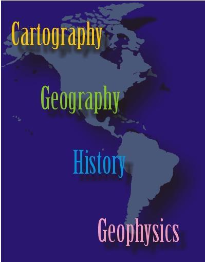
2 PAIGH Mission and Objectives To encourage, coordinate, and publicize cartographical, geographical, geophysical and historical studies to the Americas. To promote and carry out studies, work and training in these fields of activity. To promote cooperation among organizations interested in these fields of activity in the Americas, and with related international organizations. 3
3 Background The Pan American Institute of Geography and History was created February 7, 1928 Headquarters are located in Mexico In 1949, the Institute signed an agreement with the Council of the OAS and became its first Specialized Organization 4
4 Commissions 7
5 Report on ISTC committee activities June 2011 The PAIGH Member State responsible for Institutional Strengthening and Technical Cooperation (ISTC) is the United States. ISTC operates under the authority of the Cartographic Commission. ISTC promotes and increases the transfer of technologies, applications of those technologies, development and capacity building in the geosciences disciplines and GSDI in the Americas. 52
6 Finances The Pan American Institute of Geography and History is a non-profit organization Member states pay by Annual Quotas Annual Budget is $375K 9
7 IHO and PAIGH There are parallel and complementary activities between the IHO and PAIGH in function, mission, and objective. Capacity Building Hydrography MOU Between IHO and PAIGH 11
8 PAIGH ointernational Hydrographic Organization (IHO) and PAIGH signed MOU for cooperation in Feb 2011 o Member state overlap between IHO and PAIGH. o12 Member States and 2 Observers of the PAIGH are IHO members. Argentina Brazil Chile Colombia Dominican Republic (suspended membership) Ecuador Guatemala Haiti (IHO accession in progress) Mexico Peru United States Uruguay Venezuela France (PAIGH Observer) 83


9 IHO Hydrographic Commissions South East Pacific Hydrographic Commission Meso American Caribbean Hydrographic Commission US Canada Hydrographic Commission South West Atlantic Hydrographic Commission

10 PAIGH ISTC Activities Assisted IHO in Spanish translation of the Manual on Hydrography Workshop on Bathymetric Charts Multibeam Workshops in 2002 and 2004 Gulfport, Mississippi High Volume Data Collection and Processing Workshop Sept 2007 in Cartagena, Colombia 2009 Multibeam Data Collection and Processing WS. Aboard RIO TUXPAN in Mexico 13

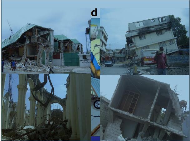
11 IHO and PAIGH Ally for Haiti 16
12 Haiti Hydrography and Nautical Charting WS othe first coordinated project between IHO and PAIGH is in establishing a Hydrography and Nautical Charting Workshop in Haiti in opaigh attended 11th Meso American Caribbean Hydrographic Commission meeting in Surinam November odonor s Meeting in Surinam resulted in funding of $16,000 plus commitment for Software, Hardware, and other development support for the Workshop. This support comes from International Organizations, national governments and Private Industry. 26
13 Haiti Donors IHO Capacity Building Sub Committee PAIGH United Kingdom Hydrographic Office Service Hydrographique et Oceanographique de la Marine Kongsberg Marine CARIS 27
14 Other activities of interest. Revitalizing the Hydrography Technical Committee. Expanding ISTC participation to other Commissions 28
15 PAIGH Hydrography Technical Committee Promote the technical cooperation and improved understanding of hydrography, nautical cartography, safety of navigation and ocean observations among the national Hydrographic Offices of the Americas. Argentina, Bolivia, Chile, Colombia, Ecuador, United States of America, Guatemala, Mexico, Panama, Peru, Uruguay, Venezuela Has not met for two years 12
16 ISTC Participation from other Commissions 30
17 HAITI Situation Haiti has created the Service D Hydrographie et d Oceanographie d Haiti (SHOH), an organization specialized and dedicated to the development of safety of navigation, maritime transport and commerce, and marine spatial data infrastructure (MSDI) in the nation. The International Hydrographic Organization (IHO) Capacity Building Committee and PAIGH ISTC Donor s Conference in conjunction in with the Meso American Caribbean Hydrographic Commission in November 2010 in Suriname. SHOH has requested the support of PAIGH and IHO for a WS to begin to develop a capacity to create nautical charts in Haitiain waters and ports. 17
18 Objective of Workshop This Hydrography and Charting WS is the first step at development of an official, modern and sustainable hydrographic office, which serves Haiti in the following tasks: the data gathering, the data processing, the data sharing in order to prepare and update the paper and electronic nautical charts, and development of a Marine Spatial Data Infrastructure (MSDI). 20
19 Basic Plan The period of implementation of the WS will be approximately three weeks. The coordinator of the national authorities for the purposes of the project will be SHOH. The steps for the development of the project are: a) On site Evaluation: b) c) Development of WS Plan: Arrangement of WS resources including trainers, SW, HW, survey platform, and facilities: 18
20 Basic Plan d) WS execution e) Depending on the extent of the IHO CBSC and other contributions the funding for the WS will go to pay for training acquired through commercial sources, travel and perdiem for trainers who are made available by supporting and donating agencies. 19
21 PAIGH Proposal Combine PAIGH Institutional Strengthening and Technical Cooperation Committee Funds with IHO CBSC to maximize the value of our interests. PAIGH funding requested for 8k 23
22 24
23 The principal target of the project is To provide Haiti with the first steps to develop a modern and efficient system through which the processed hydrographic data is compiled in order to produce up-to-date Electronic Nautical Charts and derive Paper Nautical Charts. The produced ENCs will be the base for paper chart production. 21
24 Haiti lacks modern development of its hydrographic and cartographic services, when compared with the requirements and challenges for competitivity and efficiency demanded complete nor up-to-date, and the existing charts, produced and distributed by other nations are based on hydrographic surveys that require to be updated. The cartographic coverage given may satisfy the requirements of international navigation but is not sufficient to meet the national requirements about coastal zone management, recreational boating, control of pollution and port and coastal engineering 22
25 International engagement can undermine the legitimacy and the capacity of the state Projects that operate independently of local government system constrains long-term development. Despite being essential to get the job done in the short run, parallel projects weaken the national programs and create distortions. National ownership and leadership. The funds which should be at the state s disposal are diverted. This raises the issue of national ownership and leadership. Some nationals would like to limit the role of international partners to technical assistance and implementation, so that they are no longer involved in the design of strategies or policies. Salary differences. The discrepancy between national pay scales and the levels of remuneration offered by international NGOs and donors to their employees is harmful. State officials desert the public sector to join better-paying foreign-based organizations. With comparable skills, a foreign official will always be preferred to a local official. The lack of predictability and continuity of international engagement. The sometimes short-term approach of some international actors, their frequent changes in focus and the interruption of programs without consultation could hinder medium-term planning and implementation and reduce the beneficial impact of aid. The lack of a joined-up approach to capacity development. Most visible in the use of international technical assistants who often have disparate job descriptions and come from different administrative cultures. This problem is compounded by the lack of coordination. among their local counterparts. Geographical disparities: aid tends to be overly concentrated on specific areas. 39
26 25
27 41
28 42
INTERNATIONAL HYDROGRAPHIC ORGANIZATION MESO AMERICAN & CARIBBEAN SEA HYDROGRAPHIC COMMISSION
 INTERNATIONAL HYDROGRAPHIC ORGANIZATION MESO AMERICAN & CARIBBEAN SEA HYDROGRAPHIC COMMISSION CAPACITY BUILDING PLAN Programme document for the period 2010-2012 1. INTRODUCTION 1.1. Rationale It is estimated
UN-GGIM:Americas Regional Report
 UN-GGIM:Americas Regional Report 2016-2017 Seventh Session of UN-GGIM 2-4 August 2017, United Nations Headquarters, New York. Rolando Ocampo President of UN-GGIM: Americas Content Activities, Areas of
PAN AMERICAN INSTITUTE OF GEOGRAPHY AND HISTORY Specialized Organization of the OAS
 PAN AMERICAN INSTITUTE OF GEOGRAPHY AND HISTORY Specialized Organization of the OAS 10 th UNRCC Americas United Nations, New York, 20 August 2013 PAIGH, SIRGAS, PC-IDEA and GeoSUR 2013-2015 Joint Action
Options in Capacity Building. Underpinning the Blue Economy. Slide 1/78. Derrick R. Peyton. 14 th MACHC Meeting. IIC Technologies. December 9-13, 2013
 Options in Capacity Building Underpinning the Blue Economy Derrick R. Peyton IIC Technologies 14 th MACHC Meeting December 9-13, 2013 Slide 1/78 Overview Blue Economy Defined Challenges (SDI, MSDI, Standards)
National Report Suriname 2014
 MARITIEME AUTHORITY SURINAME National Report Suriname 2014 15th MEETING OF THE MESO AMERICAN AND CARIBBEAN SEA HYDROGRAPHIC COMMISSION (MACHC) 10 13 December 2013 Manzanillo, Mexico 1. Hydrographic Office
The Pan American Institute of Geography and History (PAIGH) North America National Mapping Meeting May 10, 2018
 North America National Mapping Meeting May 10, 2018") The Pan American Institute of Geography and History (PAIGH) North America National Mapping Meeting May 10, 2018 Pan American Institute of Geography and History (PAIGH) PAIGH was founded in 1928 and their
The Pan American Institute of Geography and History (PAIGH) North America National Mapping Meeting May 10, 2018 Pan American Institute of Geography and History (PAIGH) PAIGH was founded in 1928 and their
14 th NIOHC, Myanmar National Report MYANMAR NAVAL HYDROGRAPHIC CENTRE (MNHC) NATIONAL REPORT HYDROGRAPHIC DEPARTMENT, ROYAL THAI NAVY-HDRTN
 NATIONAL REPORT HYDROGRAPHIC DEPARTMENT, ROYAL THAI NAVY-HDRTN") 14 th NIOHC, Myanmar National Report MYANMAR NAVAL HYDROGRAPHIC CENTRE (MNHC) NATIONAL REPORT 14 th NORTH INDIAN OCEAN HYDROGRAPHIC COMMISSION CONFERENCE HYDROGRAPHIC DEPARTMENT, ROYAL THAI NAVY-HDRTN
14 th NIOHC, Myanmar National Report MYANMAR NAVAL HYDROGRAPHIC CENTRE (MNHC) NATIONAL REPORT 14 th NORTH INDIAN OCEAN HYDROGRAPHIC COMMISSION CONFERENCE HYDROGRAPHIC DEPARTMENT, ROYAL THAI NAVY-HDRTN
2018/1 The integration of statistical and geospatial information. The Regional Committee of UN-GGIM: Americas:
 The following are the conclusions and recommendations of the Regional Committee of the United Nations on Global Geospatial Information Management for the Americas, during its Fifth Session, Thursday 8
IHO Input to the Report of the UN Secretary General on Oceans and Law of the Sea Executive Summary General
 IHO Input to the Report of the UN Secretary General on Oceans and Law of the Sea The following notes provide information on activities of the International Hydrographic Organization that are relevant to
Policies towards SDI development and implementation in the Americas
 Policies towards SDI development and implementation in the Americas Valéria Oliveira Henrique de Araújo Executive Secretary of CP-IDEA Brazilian Institute of Geography and Statistics - IBGE Geospatial
REPORT BY THE HYDROGRAPHIC AND GEODETIC SERVICE OF THE REPUBLIC OF CUBA. 18 th MESO AMERICAN AND CARIBBEAN SEA HYDROGRAPHIC COMMISSION MEETING
 REPORT BY THE HYDROGRAPHIC AND GEODETIC SERVICE OF THE REPUBLIC OF CUBA 18 th MESO AMERICAN AND CARIBBEAN SEA HYDROGRAPHIC COMMISSION MEETING 1. STRUCTURE OF THE HYDROGRAPHIC AND GEODETIC SERVICE OF THE
Incorporation of the Caribbean to the Geocentric Reference System for the Americas SIRGAS
 Incorporation of the Caribbean to the Geocentric Reference System for the Americas SIRGAS W. Martínez M. V. Mackern V. Cioce R. Rodino S.R. De Freitas UN-GGIM: Americas Third Session, October 5 2016, Mexico
IHO MSDI Forum 30 January 2013 The IHO perspective - Is there a new role for national HO and IHO?
 International Hydrographic Organization IHO MSDI Forum 30 January 2013 The IHO perspective - Is there a new role for national HO and IHO? Michel Huet IHB XVIIIth IHC, Monaco, Apr. 2012 The main aim for
R E P U B L I C O F C Y P R U S. NATIONAL REPORT OF CYPRUS TO THE 19 th MEDITERRANEAN AND BLACK SEAS HYDROGRAPHIC COMMISSION (MBSHC)
") R E P U B L I C O F C Y P R U S NATIONAL REPORT OF CYPRUS TO THE 19 th MEDITERRANEAN AND BLACK SEAS HYDROGRAPHIC COMMISSION (MBSHC) BATUMI MEETING 30 JUNE TO 02 JULY 2015 NATIONAL REPORT OF CYPRUS TO THE
R E P U B L I C O F C Y P R U S NATIONAL REPORT OF CYPRUS TO THE 19 th MEDITERRANEAN AND BLACK SEAS HYDROGRAPHIC COMMISSION (MBSHC) BATUMI MEETING 30 JUNE TO 02 JULY 2015 NATIONAL REPORT OF CYPRUS TO THE
RETA 6422: Mainstreaming Environment for Poverty Reduction Category 2 Subproject
 RETA 6422: Mainstreaming Environment for Poverty Reduction Category 2 Subproject A. Basic Data 1. Subproject Title: Poverty-Environment Mapping to Support Decision Making 2. Country Director: Adrian Ruthenberg
THAILAND NATIONAL REPORT
 NIOHC18 TH National Report THAILAND NATIONAL REPORT 18 th NORTH INDIAN OCEAN HYDROGRAPHIC COMMISSION (NIOHC) CONFERENCE Goa, India 9 th 12 th April 2018-1 - CONTENTS 1. Hydrographic Office / Service 3
EuroGeoSurveys & ASGMI The Geological Surveys of Europe and IberoAmerica
 EuroGeoSurveys & ASGMI The Geological Surveys of Europe and IberoAmerica Geological Surveys, what role? Legal mandate for data & information: Research Collection Management Interpretation/transformation
8 th Arctic Regional Hydrographic Commission Meeting September 2018, Longyearbyen, Svalbard Norway
 8 th Arctic Regional Hydrographic Commission Meeting 11-13 September 2018, Longyearbyen, Svalbard Norway Status Report of the Arctic Regional Marine Spatial Data Infrastructures Working Group (ARMSDIWG)
Maritime Standards. Rafael Ponce Tom De Puyt
 Maritime Standards Rafael Ponce Tom De Puyt Content The International Hydrographic Organization - Overview - Existing Support - Committees and Working Groups - Technology - Runtime - MCS Next Generation
THAILAND NATIONAL REPORT
 NIOHC14 TH National Report THAILAND NATIONAL REPORT 14 th NORTH INDIAN OCEAN HYDROGRAPHIC COMMISSION (NIOHC) CONFERENCE Bangkok, Thailand 26 th 28 th February 2014 1 CONTENTS 1. Hydrographic Office / Service...
INTERNATIONAL HYDROGRAPHIC BUREAU 4b, quai Antoine 1er BP 445 MC MONACO CEDEX PRINCIPAUTE DE MONACO
 IHO Input to Part I of the Report of the UN Secretary General on Oceans and Law of the Sea This contribution is provided in response to letter LOS/SGR/2015 dated 10 December 2014 as the input from the
Report of Uruguay The National Spatial Data Infrastructure
 Report of Uruguay The National Spatial Data Infrastructure Prepared for High-Level Forum on Global Geospatial Information Management (GGIM) and Inaugural Session of the UN Committee of Experts on GGIM
CANADIAN HYDROGRAPHIC SERVICE
 CANADIAN HYDROGRAPHIC SERVICE Surveying and Charting Canada s Waters Since 1883 Ilulisat Maritime Workshop 2017 The Importance and Need for Hydrography Denis Hains, Hydrographer General of Canada & Director
Economic and Social Council
 United Nations Economic and Social Council Distr.: General 18 July 2016 Original: English Committee of Experts on Global Geospatial Information Management Sixth session New York, 3-5 August 2016 Item 2
Interest for HOs to cooperate with EU Commission:
 Plenary session of the European IHO Network Working Group (IENWG) Interest for HOs to cooperate with EU Commission: Why HOs and the EU Commission need a closer cooperation Rear Admiral (N) Luigi SINAPI
Economic and Social Council 10 July 2013
 ADVANCE UNEDITED VERSION UNITED NATIONS E/C.20/2013/10/Add.1 Economic and Social Council 10 July 2013 Committee of Experts on Global Geospatial Information Management Third session Cambridge, United Kingdom
GeoSUR Award Sixth Competition (2017)
") GeoSUR Award Sixth Competition (2017) GeoSUR was created in 2007 with the financial backing of the CAF and in joint coordination with the Pan American Institute of Geography and History (PAIGH). The fundamental
GeoSUR Award Sixth Competition (2017) GeoSUR was created in 2007 with the financial backing of the CAF and in joint coordination with the Pan American Institute of Geography and History (PAIGH). The fundamental
Open Geospatial Consortium activities in the Maritime domain
 Open Geospatial Consortium activities in the Maritime domain Scott Simmons Executive Director, Standards Program General Maritime efforts participants Alliance partners IHO ISO / TC 211 Members Danish
R E P U B L I C O F C Y P R U S NATIONAL REPORT OF CYPRUS TO THE MEDITERRANEAN AND BLACK SEAS HYDROGRAPHIC COMMISSION (MBSHC)
") R E P U B L I C O F C Y P R U S NATIONAL REPORT OF CYPRUS TO THE MEDITERRANEAN AND BLACK SEAS HYDROGRAPHIC COMMISSION (MBSHC) ISTANBUL MEETING 25-27 SEPTEMBER 2013 NATIONAL REPORT OF CYPRUS TO THE MEDITERRANEAN
R E P U B L I C O F C Y P R U S NATIONAL REPORT OF CYPRUS TO THE MEDITERRANEAN AND BLACK SEAS HYDROGRAPHIC COMMISSION (MBSHC) ISTANBUL MEETING 25-27 SEPTEMBER 2013 NATIONAL REPORT OF CYPRUS TO THE MEDITERRANEAN
DRAFT PROGRAM Registration of participants, welcome coffee, exhibition tour
 DRAFT PROGRAM 20 Feb 2018 09.00-10.00 Registration of participants, welcome coffee, exhibition tour 10.00 12.00 ROUND TABLE: INTERNATIONAL COOPERATION IN THE ARCTIC PROJECTS: CHALLENGES AND OPPORTUNITIES
GIS Geographical Information Systems. GIS Management
 GIS Geographical Information Systems GIS Management Difficulties on establishing a GIS Funding GIS Determining Project Standards Data Gathering Map Development Recruiting GIS Professionals Educating Staff
AMERICAS GLOBAL MAP PROPOSED TECHNICAL PLAN
 AMERICAS GLOBAL MAP PROPOSED TECHNICAL PLAN A Way to Pan-American Integration PATROCINADO POR : Pan-American Institute for Geography and History - PAIGH International Steering Committee for Global Mapping
Major Opportunities in Spatial Data Infrastructure Communities
 Major Opportunities in Spatial Data Infrastructure Communities Bas Kok President GSDI June 17 th 2008 FIG Working Week: Integrating Generations 14-19 June 2008 Stockholm, Sweden http://www.gsdi.org 1 GSDI
Seabed knowledge In support of UN SDGs
 Seabed knowledge In support of UN SDGs Evert Flier Fiskerifaglig forum 2. november 2017 Hydrography & small scale fishing Hydrography in Transition Serving the Maritime Community Hydrography in Transition
Inventory of United Nations Resolutions on Cartography Coordination, Geographic Information and SDI 1
 Inventory of United Nations Resolutions on Cartography Coordination, Geographic Information and SDI I. Resolutions on Cartography Coordination and Establishment of United Nations Regional Cartographic
GEOMATICA 2004 Geospatial Technology: Trends and Opportunities La Habana, Cuba, May, 2004
 IHB File No. S1/3008 CIRCULAR LETTER 29/2004 23 April 2004 GEOMATICA 2004 Geospatial Technology: Trends and Opportunities La Habana, Cuba, 10-14 May, 2004 Reference: IHB Circular Letter 74/2003, dated
Development Of Common Frameworks And Methodologies *
 HIGH LEVEL FORUM ON GLOBAL GEOSPATIAL MANAGEMENT INFORMATION WORKING PAPER No. 9 First Forum Seoul, Republic of Korea, 24-26 October 2011 Development Of Common Frameworks And Methodologies * * Submitted
Global Spatial Data Infrastructure Association
 http://www.gsdi.org Global Spatial Data Infrastructure Association a global forum to support exchange of ideas and encourage joint activities at the global level Members: Think global, act local Organization:
Dr. Biliana Cicin-Sain 8 April th Meeting of the UN Open-ended Informal Consultative Process on Oceans and the Law of the Sea
 Enabling Factors in Achieving Sustainable Development of Oceans: Experiences with National and Regional Ocean Policies and Implications for the Implementation of Goal 14 on Oceans and Seas Dr. Biliana
XXII GENERAL ASSEMBLY OF MINISTERS AND MAXIMUM AUTHORITIES OF HOUSING AND URBANISM OF LATIN AMERICA AND THE CARIBBEAN
 XXII GENERAL ASSEMBLY OF MINISTERS AND MAXIMUM AUTHORITIES OF HOUSING AND URBANISM OF LATIN AMERICA AND THE CARIBBEAN Taking into account: Santiago, Chile 1 and 2 October 2013 DECLARATION OF SANTIAGO 1.
EUSAIR on sea topics from Slovenian perspective
 MINISTRY OF FOREIGN AFFAIRS REPUBLIC OF SLOVENIA EUSAIR on sea topics from Slovenian perspective Mag. Andreja Jerina National Coordinator 4 EU MRS: 270 millions of population 19 MS 12 non MS Sea basin
Funding systems used in Mexico to support institutional arrangements: INEGI case
 Funding systems used in Mexico to support institutional arrangements: INEGI case Sistemas de financiamiento usados en México, para soportar arreglos institucionales: Caso INEGI United Nations Committee
Current Hydrographic Projects at BSH
 7 th Workshop Seabed Acoustics, Rostock, November 19/20, 2015 P01-1 Current Hydrographic Projects at BSH Thomas Dehling Federal Maritime and Hydrographic Agency (BSH) Germany Contact Address Website BSH
The role of the Italian Navy Hydrographic Institute in the Arctic activities
 The role of the Italian Navy Hydrographic Institute in the Arctic activities Luigi Sinapi Director of the Italian Hydrographic Institute Early Arctic hydrographic surveys ICE ICE Arctic hydrographic monitoring
Faatasi Malologa (PGSC Chair) Director Department of Lands & Survey, Tuvalu
 Director Department of Lands & Survey, Tuvalu") Seventh Session of the United Nations Committee of Experts on Global Geospatial Information Management (UN-GGIM) - 31 July -4 August 2017 Faatasi Malologa (PGSC Chair) Director Department of Lands & Survey,
Seventh Session of the United Nations Committee of Experts on Global Geospatial Information Management (UN-GGIM) - 31 July -4 August 2017 Faatasi Malologa (PGSC Chair) Director Department of Lands & Survey,
COUNTRY REPORT ON CARTOGRAPHIC ACTIVITIES IN SINGAPORE ( ) Submitted by Singapore **
 Submitted by Singapore **") UNITED NATIONS E/CONF.97/5/CRP. 9 ECONOMIC AND SOCIAL COUNCIL Seventeenth United Nations Regional Cartographic Conference for Asia and the Pacific Bangkok, 18-22 September 2006 Item 6 (b) of the provisional
UNITED NATIONS E/CONF.97/5/CRP. 9 ECONOMIC AND SOCIAL COUNCIL Seventeenth United Nations Regional Cartographic Conference for Asia and the Pacific Bangkok, 18-22 September 2006 Item 6 (b) of the provisional
Hydrography at MSc and Category A level: a European perspective. Victor Abbott & Nicolas Seube
 Hydrography at MSc and Category A level: a European perspective Victor Abbott & Nicolas Seube La Manche A map of our localities... Plymouth University of Plymouth RNHMS Training School Plymouth Martine
Briefing Notes for World Hydrography Day
 Briefing Notes for World Hydrography Day - 2017 Mapping our seas, oceans and waterways - more important than ever Purpose of World Hydrography Day In 2005, the General Assembly of the United Nations (UN)
UN GGIM and National SDI Strategy
 MSDI Open Forum on 26 th January 2016 Contributing to the successful delivery of MSDI UN GGIM and National SDI Strategy Hiroshi Murakami Deputy Administrator Geospatial Information Authority of Japan Geospatial
Copernicus Academy. Roles and responsibilities of the Copernicus Academy. user uptake. Focus Data uptake, capacity building and skills development
 Copernicus Academy user uptake Roles and responsibilities of the Copernicus Academy The European Commission has launched two Networks, the Copernicus Relays and the Copernicus Academy, to contribute on
ACCESSIBILITY TO SERVICES IN REGIONS AND CITIES: MEASURES AND POLICIES NOTE FOR THE WPTI WORKSHOP, 18 JUNE 2013
 ACCESSIBILITY TO SERVICES IN REGIONS AND CITIES: MEASURES AND POLICIES NOTE FOR THE WPTI WORKSHOP, 18 JUNE 2013 1. Significant differences in the access to basic and advanced services, such as transport,
Annual Ministerial Meeting of Foreign Ministers of Landlocked Developing Countries
 Annual Ministerial Meeting of Foreign Ministers of Landlocked Developing Countries 28 September 2018 10:00am - 1:00pm Conference room 5 UN Headquarters, New York Concept Note Theme: Revitalizing partnerships
Cooperation is the key, FIG can facilitate
 Cooperation is the key, FIG can facilitate Mikael Lilje Vice President 2017-2020 Head, Geodetic infrastructure, Swedish mapping, cadastral and land registration authority Presented at the GIS/RS Conference
Concept note. High-Level Seminar: Accelerating Sustainable Energy for All in Landlocked Developing Countries through Innovative Partnerships
 Concept note High-Level Seminar: Accelerating Sustainable Energy for All in Landlocked Developing Countries through Innovative Partnerships Date: 24 and 25 October 2016 Venue: Conference Room C3, Vienna
IHO Perspective on a Marine Spatial Data Infrastructure
 IHO Perspective on a Marine Spatial Data Infrastructure Anthony Pharaoh (International Hydrographic Bureau) Definitions of Hydrography on the Web: The study of the surface waters of the Earth. www.geographic.org/glossary.html
GIS TECHNICIAN I GIS TECHNICIAN II
 GIS TECHNICIAN I GIS TECHNICIAN II CITY OF ROSEVILLE DEFINITION To perform a variety of technical office and field work duties related to the creation and maintenance of maps, tables, graphs and other
United Nations, UNGEGN, and support for national geographical names standardization programmes
 Brazil, 2017 United Nations, UNGEGN, and support for national geographical names standardization programmes Helen Kerfoot, Cecille Blake UNGEGN What is important to know? Background on UNGEGN Aims of the
Regional mechanisms for satellite data access and exchange: RA III/IV
 WORLD METEOROLOGICAL ORGANIZATION COMMISSION FOR BASIC SYSTEMS OPEN PROGRAMME AREA GROUP ON INTEGRATED OBSERVING SYSTEMS EXPERT TEAM ON SATELLITE UTILIZATION AND PRODUCTS ET-SUP-8/Doc. 5.1.3 (25.III.2014)
Pacific Islands Regional Maritime Boundaries Project
 Pacific Islands Regional Maritime Boundaries Project 31 st Star Conference, Nadi, FIJI 6-8 June 2016 Jens Kruger Head of Ocean & Coastal Geoscience Sector Andrick Lal Project Officer (Surveying) Emily
NATIONAL REPORT OF ESTONIA
 BSHC 21 th Conference 27-29 Sept 2016 Klaipeda, Lithuania NATIONAL REPORT OF ESTONIA Executive summary This report summarizes the activities of the Estonian Maritime Administration in the field of hydrography
International Dark Sky Community Annual Designation Update 2018
 International Dark Sky Community Annual Designation Update 2018 EXECUTIVE SUMMARY Bon Accord has completed and maintained the majority of schedule of projects within the original designation application
Marine Spatial Planning: A Tool for Implementing Ecosystem-Based Management
 Marine Spatial Planning: A Tool for Implementing Ecosystem-Based Management Steven Murawski, Ph.D., Ecosystem Goal Team Lead National Oceanic and Atmospheric Administration NOAA November 16, 2009 1 To
Chris Rizos (IAG), Chair William Cartwright (ICA), immediate past Chair
, Chair William Cartwright (ICA), immediate past Chair") Chris Rizos (IAG), Chair William Cartwright (ICA), immediate past Chair Global Spatial Data Infrastructure (GSDI) Association IEEE Geoscience & Remote Sensing Society (IEEE-GRSS) International Association
Chris Rizos (IAG), Chair William Cartwright (ICA), immediate past Chair Global Spatial Data Infrastructure (GSDI) Association IEEE Geoscience & Remote Sensing Society (IEEE-GRSS) International Association
HYDROGRAPHIC SECTION QATAR NATIONAL REPORT TO THE 6 TH ROPME SEA AREA HYDROGRAPHIC COMMISSION MEETING
 HYDROGRAPHIC SECTION QATAR NATIONAL REPORT TO THE 6 TH ROPME SEA AREA HYDROGRAPHIC COMMISSION MEETING ABU DHABI, UNITED ARAB EMIRATES 9 11 FEBRUARY 2015 Page left intentionally blank 1. Hydrographic Section
NSDI Implementation. Milo Robinson FGDC. U. S. Policy OMB Circular A-16 From Global GSDI To Local Canadian/ U.S. Projects
 NSDI Implementation Milo Robinson FGDC U. S. Policy OMB Circular A-16 From Global GSDI To Local Canadian/ U.S. Projects Federal Geographic Data Committee (FGDC) A US Federal Interagency committee responsible
MARINE SPATIAL PLANNING & MARINE CADASTRE: CHALLENGES AND ISSUES
 MARINE SPATIAL PLANNING & MARINE CADASTRE: CHALLENGES AND ISSUES Roger Longhorn Secretary General, GSDI Association rlonghorn@gsdi.org Member, IHO Marine SDI Working Group ral@alum.mit.edu Member, UNESCO
 BPC Policy No , IIM7fyilK Office of the District Clerk TRANSITION ZONE POLICY")
POLICY: FI/PL/03 Issued on August 5, Fee Policy for GEF Partner Agencies
 POLICY: FI/PL/03 Issued on August 5, 2012 Fee Policy for GEF Partner Agencies Summary: The proposed Agency fee structure in this paper is the decision of the GEF Council from its meeting of June 2012.
LIST OF DOCUMENTS* GROUP OF EXPERTS ON GEOGRAPHICAL NAMES. Twenty-seventh session 15 June 2016 New York, 28 April 2 May 2014
 UNITED NATIONS GROUP OF EXPERTS ON GEOGRAPHICAL NAMES GEGN/29/5/Rev.4 Twenty-seventh session 15 June 2016 New York, 28 April 2 May 2014 LIST OF DOCUMENTS* * Prepared by the UNGEGN Secretariat Symbol Title/Country
Resolutions from the Tenth United Nations Conference on the Standardization of Geographical Names, 2012, New York*
 UNITED NATIONS GROUP OF EXPERTS ON GEOGRAPHICAL NAMES Twenty-eighth session New York, 28 April 2 May 2014 GEGN/28/9 English Resolutions from the Tenth United Nations Conference on the Standardization of
NEEA Refresh aka 3D Nation Requirements and Benefits Study. Allyson Jason, Carol Ostergren, Xan Fredericks and Lou Driber November 9, 2017
 + NEEA Refresh aka 3D Nation Requirements and Benefits Study Allyson Jason, Carol Ostergren, Xan Fredericks and Lou Driber November 9, 2017 + 2 Study Context Background The National Enhanced Elevation
Briefing on the work of GEBCO (GENERAL BATHYMETRIC CHART OF THE OCEANS)
") Briefing on the work of GEBCO (GENERAL BATHYMETRIC CHART OF THE OCEANS) 7th ROPME Sea Area Hydrographic Commission Meeting, Muscat, Oman 20-22 February 2017 What is GEBCO? The General Bathymetric Chart
Briefing on the work of GEBCO (GENERAL BATHYMETRIC CHART OF THE OCEANS) 7th ROPME Sea Area Hydrographic Commission Meeting, Muscat, Oman 20-22 February 2017 What is GEBCO? The General Bathymetric Chart
Economic and Social Council
 United Nation E/C.20/2012/4/Add.1 Economic and Social Council Distr.: General 2 July 2012 Original: English Committee of Experts on Global Geospatial Information Management Second session New York, 13-15
Non-Governmental Organizations for Spatial Data Infrastructure. Environmental Democracy Case
 Non-Governmental Organizations for Spatial Data Infrastructure Environmental Democracy Case L.Jovičić, S.Vrečar, V.Cetl, K.Ristovski GSDI Small Grant Program Award 2011-2012 Non-Governmental Organisations
ECONOMIC AND SOCIAL COUNCIL
 UNITED NATIONS E/CONF.102/3 ECONOMIC AND SOCIAL COUNCIL Nineteenth United Nations Regional Cartographic Conference for Asia and the Pacific Bangkok, 29 October 1 November 2012 Item 4 of the provisional
Update to the Association of Ontario Land Surveyors February 27, 2015 Deerhurst, Ontario
 1 Update to the Association of Ontario Land Surveyors February 27, 2015 Deerhurst, Ontario Peter Sullivan CLS, ALS, MBA Director General, Surveyor General Branch Earth Sciences Sector, Natural Resources
Baltic Marine Environment Protection Commission
 Baltic Marine Environment Protection Commission Maritime Group Klaipeda, Lithuania, 23-25 November 2015 MARITIME 15-2015 Document title FAMOS Finalising Surveys for the Baltic Motorways of the Sea Code
NGO potential as a stakeholder within processes of developing the NSDI
 and 7th Cartography and Geoinformation Conference NGO potential as a stakeholder within processes of developing the NSDI Luka Jovičić, MSc. Industrial Engineering representative market NGO status needs
Executive Summary and Recommendations
 ANNEX I: EXECUTIVE SUMMARY AND RECOMMENDATIONS OF THE 12RMSD TWELFTH REGIONAL MEETING OF THE METEOROLOGICAL SERVICE DIRECTORS 30 -JUNE to 6 -JULY 2007 Rarotonga, Cook Islands Executive Summary and Recommendations
ADMINISTRATION OF GEOGRAPHICAL NAMES IN URUGUAY
 ADMINISTRATION OF GEOGRAPHICAL NAMES IN URUGUAY 1st. Lt. Julio C. Teixeira Executive Officer Geodesy & Topography Division Military Geographic Service Av. 8 de Octubre 3255. Montevideo, URUGUAY Telph.:
World Bank Group GEF Program
 World Bank Group GEF Program Global Environment Facility: -Transport World Bank GEF Coordination Team Content How does GEF work? World Bank s role in the GEF partnership The GEF transport activities What
NATIONAL REPORT OF THE HYDROGRAPHIC DEPARTMENT, ROYAL THAI NAVY
 NATIONAL REPORT OF THE HYDROGRAPHIC DEPARTMENT, ROYAL THAI NAVY to 11 th NORTH INDIAN OCEAN HYDROGRAPHIC COMMISSION MEETING NEW DELHI, INDIA 1-2 MARCH 2011 1. Hydrographic Office / Service Established
Background Document: Report of the Regional Committee of United Nations Global Geospatial Information Management for Asia and the Pacific
 Background Document: Report of the Regional Committee of United Nations Global Geospatial Information Management for Asia and the Pacific 1. Summary 1. This report highlights the activities carried out
The Danish Maritime Spatial Data Infrastructure (MSDI) Geodata of the Sea
 Geodata of the Sea") MSDI/MSP The Danish Maritime Spatial Data Infrastructure (MSDI) Geodata of the Sea Components of an infrastructure: DATA - metadata, datasets FUNCTIONALITY - spatial data services, web services and other
MSDI/MSP The Danish Maritime Spatial Data Infrastructure (MSDI) Geodata of the Sea Components of an infrastructure: DATA - metadata, datasets FUNCTIONALITY - spatial data services, web services and other
Arctic Regional Hydrographic Commission (ARHC) Portsmouth, New Hampshire, United States, January 29-30, Hydrographic National Report of Denmark
 Portsmouth, New Hampshire, United States, January 29-30, Hydrographic National Report of Denmark") ARHC4-2.2 Arctic Regional Hydrographic Commission (ARHC) Portsmouth, New Hampshire, United States, January 29-30, 2014 Hydrographic National Report of Denmark January 2014 1. Hydrographic Office January
ARHC4-2.2 Arctic Regional Hydrographic Commission (ARHC) Portsmouth, New Hampshire, United States, January 29-30, 2014 Hydrographic National Report of Denmark January 2014 1. Hydrographic Office January
PORTUGAL NATIONAL REPORT
 PORTUGAL NATIONAL REPORT 14 TH MEETING OF THE EASTERN ATLANTIC HYDROGRAPHIC COMMISSION Cadiz, Spain 18 th 20 th October 2016 INSTITUTO HIDROGRÁFICO Miguel Arenga IHPT Head of the Hydrography Division 2016-10-18
PORTUGAL NATIONAL REPORT
 PORTUGAL NATIONAL REPORT 13 TH SOUTHERN AFRICA AND ISLANDS HYDROGRAPHIC COMMISSION MEETING Cape Town, South Africa 29 th 31 st August 2016 INSTITUTO HIDROGRÁFICO Miguel Arenga IHPT Head of the Hydrography
UN-GGIM: An Overview Stefan Schweinfest, Director (UNSD) Bangkok, 27 March 2015
 Bangkok, 27 March 2015") UN-GGIM: An Overview Stefan Schweinfest, Director (UNSD) Bangkok, 27 March 2015 ggim.un.org UN-GGIM: A global initiative Formal inter-governmental UN Committee of Experts to: Discuss, enhance and coordinate
UN-GGIM: An Overview Stefan Schweinfest, Director (UNSD) Bangkok, 27 March 2015 ggim.un.org UN-GGIM: A global initiative Formal inter-governmental UN Committee of Experts to: Discuss, enhance and coordinate
Statewide Topographic Mapping Program
 Statewide Topographic Mapping Program February 28, 2018 www.dotd.la.gov Outline Purpose of the Statewide Topographic Mapping Program History Breakdown of R.S. 48:36 - Topographic Mapping Statewide Topographic
PC-IDEA Final Report of Activities
 PC-IDEA Final Report of Activities Luiz Paulo Souto Fortes President of PC-IDEA 10 th United Nations Regional Cartographic Conference for the Americas 19-23 August 2013, New York, United States Permanent
Shetland Islands Council
 Shetland Islands Council Response to EU Green Paper on Territorial Cohesion Shetland Islands Council is strongly in favour of a territorial dimension to cohesion policy and welcomes the Commission s consultation
Economic and Social Council
 United Nations Economic and Social Council Distr.: General 23 May 2012 Original: English E/CONF.101/100 Tenth United Nations Conference on the Standardization of Geographical Names New York, 31 July 9
GIS ADMINISTRATOR / WEB DEVELOPER EVANSVILLE-VANDERBURGH COUNTY AREA PLAN COMMISSION
 GIS ADMINISTRATOR / WEB DEVELOPER EVANSVILLE-VANDERBURGH COUNTY AREA PLAN COMMISSION SALARY RANGE INITIATION $43,277 SIX MONTHS $45,367 POSITION GRADE PAT VI The Evansville-Vanderburgh County Area Plan
Funding models for institutional arrangements in the context of a national SDI: the case of Chile
 Funding models for institutional arrangements in the context of a national SDI: the case of Chile Alvaro Monett Hernández Executive Secretary SNIT Chile Vice-President UN-GGIM Américas Fifth Meeting of
WGCapD Support to AmeriGEOSS Week Disaster Training Report
 WGCapD Support to AmeriGEOSS Week Disaster Training Report 1 6-9 June 2016 CEOS WGCapD Support to AmeriGEOSS Week Disaster training DRAFT REPORT Hosted by: The government's Institute of Hydrology, Meteorology,
Oregon Department of Transportation. Geographic Information Systems Strategic Plan
 Oregon Department of Transportation Geographic Information Systems Strategic Plan Adopted May, 2000 By the GIS Steering Committee Last printed 10/2/2012 4:20:00 PM Page Geographic Information Systems Strategic
Geographical Names Activities in Africa The Gaborone Action Plan
 United Nations Group of Experts on Geographical Names Geographical Names Activities in Africa The Gaborone Action Plan 6 th Meeting of the Committee of Director -Generals of National Statistics Offices
Weatherford. All rights reserved.
 Compliance Challenges in Latin America Utilities & Energy Compliance & Ethics Conference February 2012, Houston Texas Office of Global Compliance Ethics & Compliance Group Marco Antonio Padilla Merigo
Areas Beyond National Jurisdiction (ABNJ) 2016 Regional Leaders Program. March 22 to April 1, 2016 United Nations, New York
 2016 Regional Leaders Program. March 22 to April 1, 2016 United Nations, New York") Areas Beyond National Jurisdiction (ABNJ) 2016 Regional Leaders Program March 22 to April 1, 2016 United Nations, New York Welcome and Introductions Biliana Cicin-Sain President, Global Ocean Forum Vladimir
Areas Beyond National Jurisdiction (ABNJ) 2016 Regional Leaders Program March 22 to April 1, 2016 United Nations, New York Welcome and Introductions Biliana Cicin-Sain President, Global Ocean Forum Vladimir
Report of PCGIAP to the 18 th United Nations Regional Cartographic Conference for Asia and the Pacific (UNRCC-AP) for the period
 for the period") Permanent Committee on GIS Infrastructure for Asia and the Pacific (PCGIAP) Established in 1995 by a United Nations Resolution Report of PCGIAP to the 18 th United Nations Regional Cartographic Conference
Permanent Committee on GIS Infrastructure for Asia and the Pacific (PCGIAP) Established in 1995 by a United Nations Resolution Report of PCGIAP to the 18 th United Nations Regional Cartographic Conference