Restoration and Improvement of Coastal Environment Devastated by the Tsunami. Tilak Ranaviraja
|
|
|
- Theodora Roberts
- 5 years ago
- Views:
Transcription
1 Restoration and Improvement of Coastal Environment Devastated by the Tsunami Tilak Ranaviraja The impact of the tsunami on the people, infrastructure, environment and economy of Sri Lanka was very high when compared to other affected countries in relation to the size of the country, size of the population, economy and the affected extent of the environment. Yet Sri Lanka successfully handled the measures of evacuation, relief, restoration of infrastructure and livelihoods with the assistance of the international community. The Government of Sri Lanka was unable to give priority to environment in the fist one or two months of restoration and rehabilitation. However this situation was corrected subsequently. One such step was to recognize setback areas in the coastal zone of the country after considering representations made by human rights groups, international community. In April 2005 with the assistance of the United Nations Environmental Programme (UNEP) and Canadian International Development Agency (CIDA), a study was initiated by the Ministry of Environment and a detailed report was compiled. UNEP assisted by CIDA supported an island-wide programme of Rapid Environmental Assessments (REA) of 480 sites for the Central Environment Authority (CEA). A powerful methodology which harnesses public participation and multi-stakeholder dialogue is to promote environmental sustainability of individual projects. This methodology has recently been underlined by HE the President through his endorsement to Cabinet of Ministers for future mandatory Strategic Environment Assessments (SEAs) for development activities. Sri Lanka is in the process of utilizing scientific approaches based on the results of the studies and surveys in such a way that the coastal areas are developed with fishery and other economic activities including tourism and recreation like water sports to bring benefits to the coastal communities and ensure that the environment cohabits with development
2 Spatial Information-based Approach to Integrated Coastal Resource Management in Asian Tsunami Affected Countries Tariful Islam & Sugianto Saman FAO Regional Workshop on Coastal Area Planning & Management September, 2006, Bangkok, Thailand Introduction 1. CA is a rich environment of high biological and physical diversity from an ecological perspective 2. Generally, coastal zone shows high population density with large number of urban conglomeration 3. Agriculture, fisheries and forestry are the key resources in the CA and also provide livelihoods 4. Coastal resource system is interdependent and interrelated and also has direct and indirect connections with inland resource systems 5. Interaction between various natural processes and human activity are important factors in the CA 6. Therefore, there is an urgent need for intelligent management of CA 7. To do so an Integrated Coastal Resource Management (ICRM) process is needed 2 Contd. 8. Immediate priority of each country affected by the tsunami was to attend emergency followed by efforts to rehabilitate and reconstruct 9. In order to support the rehabilitation and reconstruction activities, GIS, relevant digital maps, and geospatial data have to be prepared as a planning tool 10. Various type of information can also be extracted by interpreting high-resolution satellite images acquired before and after tsunami event 11. This combined effort will help to generate valuable information which will be useful for any kind of planning purpose 3 Rationale for Developing an Integrated Approach Tsunami damage was huge, partly due to the bad land use planning and NR management Land use and site planning should be emphasized in keeping new development area out of hazard zones Coastal resources management includes a wide array of management practices Land use and site planning for tsunami-affected areas relate to CRM CRM is too complex to be handled by traditional sectoral planning and management ICRM can improve basis for spatial planning, reconstruction and protection of people and infrastructure and ecosystems Integrated management of the complex problem in the coastal area can be achieved by means of spatial information system 4 Objectives To solve conflicts and/or find optimal solutions, the integration of recent tools such as GIS, GPS, RS, with data management, data analysis and modeling is required. Hence, this paper attempts to identify how GIS technology can support to post-rehabilitation reconstruction and development efforts as well as integrated costal resource planning and management in Asian tsunami affected coastal areas. Spatial information technology for ICRM Spatial information technology can be used as decision support system to assist decision-making. Spatial information technologies include three major types: Global Positioning System (GPS) Remote Sensing (Airborne and Satellite) Geographical Information Systems (GIS) These three categories are related and often employed in an integrated fashion; remote sensing images and GPS data serve as input into GIS, and aerial and satellite images are often verified or ground-truthed with GPS co-ordinates

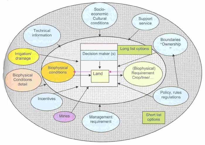
3 Information requirements for ICRM Geographical data: This is the "Where" something is and the "What" it is? Spatial data Attribute/Aspatial Data Sources of Spatial Data Hard copy maps Aerial photographs Remotely-sensed imagery Point data samples from surveys Existing digital data files 7 Application Areas of GIS Technology to CRM Coastal resource survey and management Coastal change monitoring and analysis Modelling coastal process Coastal decision-making and policy formulation Integrated Land Use Planning (ILUP) Uncontrolled/unplanned land use is taking place throughout the developing countries and tsunami affected coastal areas are no different from it rather worst in some places where fast development have been taking place. Thus, forest/land clearing and degradation is an on-going process and the speed of clearing is increasing. 8 Use of Maps in ILUP and NRM Use of maps (and spatial information) in NRM and LUP is very essential to improve sustainable and equitable use of land and natural resources, through participatory community and local level planning and investment Because map/spatial information can help for sustainable management of land and natural resources which is critical to improving people s living standard, both now and in the future Factors which lead to effective community based land use planning and natural resource management include: Clear legal status of land and resource use rights for individuals and communities Stakeholders have a strong awareness of their reliance on land and natural resources for subsistence and economic development, both in the short and long term Availability of information about the current status and trends of resources, resource use and communities Maps and participatory mapping processes can be used to support all of these factors, as illustrated in the following diagram: 9 Land Suitability Approach, an overview for determining potential use under current and future conditions Management of natural resources is a cross boundary issue that should be emphasized in all planning processes within a multi-sectoral approach (administrative and geographical) Land suitability is a part of LUP methodology and defines possible options for the future land use and helps to describe these interactions (policies, institutional and information arrangement) It also gives an overview of NREM situation related to forestry, fisheries, land and agriculture based on existing information at sub-national or province level in coastal areas The matching process of different conditions and requirements can vary depending on the purpose and level of detail of LUP and by the amount and quality of information that has been collected (Table 1) 10 Contd. This approach provides for different level (national, provincial, district, sub-district) maps, analyses, and an overview sheet about the past/present NREM situation and gives possible options for the future activity based on existing information It can provide a geographical starting point (where to do?, land investor/planner) or a starting point (what to do?, land owner/planner) The starting point of this approach is land (demand driven, what can I do on my land?) or the requirement of the crop/tree etc (market driven, where the land is suitable for.?) The first matching will be made considering the biophysical condition of the land (slope, soil, climate, land use etc.) These options require additional requirements/conditions/limitations, which leave a short list of options that still need to go through an EIA especially when infrastructure is involved (roads, canals) This is a dynamic process and should be done regularly when new information is provided (e.g. BRR for Indonesia) 11 SI for Sustainable LUP and Management When adopting multi-level stakeholder approach to SLM Scientific information must be coupled with indigenous knowledge (ITK, TEK) to offer a better basis for decisionmaking in negotiation processes Here GIS and maps may serve as appropriate tools to facilitate communication in negotiation process SI/map in LUP is effective tools (Mueller Son La, 2003 and adjusted) in many ways, such as: Boundary delineation, mediate and solve prevailing boundary conflicts Accurately scaled information for official approval Starting point for participatory problem analysis and future land use planning Create a common understanding among local land users and administrative authorities on spatial distribution and status of resources and resource use Acquire accurate large scale spatial data on the basis of local knowledge Define land uses and land tenure 12 2
4 Diagram Effective land use planning and sustainable natural resource use Legal status Awareness Information Administration boundaries Land tenure boundaries Use sketch or scale maps to help raise awareness Nationally available data on resources such as forests or water Boundary delineation with stakeholders to resolve conflicts Acceptance of local plans by higher authorities Analyse trends in land and resource quality or use, and socio-economic factors Participatory mapping of land use and other features using air photos, GPS and consultation with community Figure: Some of the ways in which maps and mapping processes can facilitate effective land use planning and natural resource management.
5 Table 1: Matching administrative and ecological boundaries for planning overview with issues (Adapted from FAO, 1996 & Ignas, 2004). Administrative units Biophysical units Scale Planning process/principle International Biosphere 1:1,000,000 Environmental and 1:5,000,000 economic agreements National Eco-zones 1:25,000 1:2,500,000 Province Watershed 1:50,000-1:250,000 District Sub-district/ village Field/productio n unit (site specific) Watershed, Island Small watershed, Common property resources (e.g. wetland, dam, forest land) Paddock level, Field/bondo/sm all holders' plot (e.g. Bangladesh), community pond etc. 1:10,000 1:100,000 1:1,000 1:50,000 1:1,000 1:5,000 National Land Use Plans, Market development Master planning (e.g. provincial investment plan) District planning workshop, District Master plan, Watershed Management Plan Village/Sub-district land Use Plan, Village Regulation and Management Plan for communal areas, Urban Master Plan Whole farm land Use Plan, Fish farming, grazing plan, cropping pattern/calendar, water use plan Issues (Conventions and Treaties) Land degradation, preservation of biodiversity, water sharing, water pollution, human development and food security, climate change and agricultural potentials, awareness of regional and global institutions. (Millennium Development Goals/ PRS) Agro-ecological potentials, use of irrigation water resources, risk of natural calamities, food security and production, conservation of natural resources and biodiversity, land degradation, public awareness Sets provincial priorities, coordination; Technical knowledge and service All districts connecting local plans with plans from provincial departments, NGOs, and donors NREM mainstreaming into local planning process; Viable production systems, food requirements, social and economic needs satisfaction, awareness farmers/land users Conservation of soils and water, high levels of soil fertility, low levels of soil and water pollutants, low levels of crop pests and animal diseases, increase fish productivity
6 Approach


7 Use of Spatial Information for Coastal Area Management in Banda Aceh An Example An example can be given from Banda Aceh and surroundings for showing how spatial information can be helpful in land suitability analysis and spatial planning. Kota Banda Aceh is situated on an extensive low coastal plain between the two main coastal mountain ranges at the northern tip of Aceh Province: the eastern half of the Kabupaten is coastal beach ridges and swales and the western half is coalescent estuarine/riverine plains. The plain extended 42 km inland with a small indentation at a point where the two coastal mountain ranges merged to become a single range. At the head of the valley elevations are 100 m. A large area (4,409.6 ha) has been mapped as damaged by the tsunami in this Kota. Mangroves were present before the tsunami with 90.3 ha mapped in the western side of the Kabupaten; all were destroyed by the tsunami. Tambak Suitability Analysis: This Kabupaten had one of the largest areas of 3,443.7 ha mapped as potentially suitable for Tambak development is shown in the table 2. Table 2: Tambak suitability mapping for Banda Aceh and surroundings using GIS approach Tambak Suitability Mapping Area (Ha) Optimal Low (< 5m), flat (<5%), close to river (<2 km) and sea (<1 km) Prime 1 Low (<5m), flat (<5%), close to sea (<1 km) but far (>2 from river) 13.6 Prime 2 Low (<5m), flat (<5%), close to river (<2 km) and moderate close to sea (1-2km) Prime 3 Low (<5m), flat (<5%), moderate close to sea (<1-2 km) and far from river (>2 km) 0.6 Prime 4 Elevated (5-10 m), flat (<5%), and close to sea (<1 km) and river (< km) Prime 5 Elevated (5-10 m), flat (<5%), close to sea (<1 km) but far (>2 km) from river 1.1 Marginal 1: Elevated (5-10m), flat (<5%), moderate close to sea (1-2 km) but far from river (>2km) 0.5 Marginal 2: Low (<5m), flat (<5%), close to river (<2 km) but far from sea (>2km) 1,129.8 Marginal 3: Elevated (5-10m), flat (<5%), close to river (<2 km) and moderate close to sea (1-2km) Pooled 3,443.7 Couples of maps from Aceh province are shown below to visualize how GIS technology can be used in identifying different locations of interest and in spatial planning. The map (Figure 6) is showing 13 affected districts (pink) of Aceh province from the 26 December 2004 tsunami. Red lines are showing the four special priority districts for resettlement. The map is showing (Figure 7) example of coastline changes and of tsunami damages extent over Banda Aceh area; and is categorized as non-affected areas (green); damaged (pink); coastline lost (blue). Figure 6: Locations of tsunami affected areas in Aceh Figure 7: Post-tsunami coastlines change
 and thereby, lots of unplanned development activities and natural resource")
 is showing how current population number and potential resettlement land by Desa along with other factors like infrastructure, economic development, future population etc.")


8 The map (Figure 8) is showing the current trend of post-tsunami population movement (red arrows) for resettlement. However, it is a likely scenario that this trend might be again changed soon towards coastal areas (yellow arrows) and thereby, lots of unplanned development activities and natural resource extraction might happen if a sound spatial planning is not considered right away. The map (Figure 9) is showing how current population number and potential resettlement land by Desa along with other factors like infrastructure, economic development, future population etc. can be used for an appropriate spatial planning. The map (Figure 10) is showing options for resettlement considering the land suitability in Banda Aceh. Areas showing with red color are unsuitable for settlement or already under use. The areas showing with green color are suitable or can be used for resettlement purpose. The Map (Figure 11) is showing how reef habitat mapping can be done using GIS and spot (satellite image). Figure 8: Urban expansion scenario in Banda Aceh Figure 9: Spatial planning for resettlement Figure 10: Resettlement option of Banda Aceh Figure 11: Reef Habitat mapping (Source of Map 8-10 is ARRIS: Aceh Rehabilitation and Reconstruction Information System). This example reveals that to support the rehabilitation and reconstruction activities, a geographic information system, relevant digital maps, and digital geospatial data have to be prepared as a planning tool for sustainable ICRM. Different type of required information (spatial and non-spatial) should be acquired before and after the tsunami event. It also suggests that the ICRM planning and implementation process in post-

9 tsunami coastal areas should have a multi-sectoral approach at the vertical (accommodation decentralization) and horizontal (range of sectors) levels to ensure commitment and co-management in implementation. Table 1 shows the linkages between the administrative and ecological biophysical boundaries. It provides an example of ways in which work from villages can be linked to other planning initiatives at a higher level. PCS map
10 Contd. Allow identification and accurate location of natural resources, their distribution, use and tenure facilitate communication between facilitator teams and villagers (maps are mobile) Impact monitoring for rural development investment Contour lines or a shade effect can be added to give a third dimension (upstream-downstream linkages) Thematic maps (soil, climate etc.) as source for information about land suitability Historical maps give explanations about land use in the past To identify areas for multi-purpose development opportunities (e.g. Zonation map) Help to identify problems (including size), describing the causes and finding solution (including time frame) within their respective administrative boundaries e.g. PCS map. This map is showing different NR related problems (with various logical symbols), causes and solutions identified by the community. Help to show the prioritized activities/projects and use for monitoring purpose as well (e.g. Activity map) 13 Summary & Conclusion ICRM requires integration of quantitative science and engineering components with socio-political, regulatory, and economic considerations It will provide some of the tools for effective decision support in NRM in coastal areas ICRM must be aimed at maximizing synergistic and complementary interactions and minimizing competitive and antagonistic ones However, sound policies require sound information To provide formal yet practical decision support requires a new approach, which supports a more open and participatory decision making process The paradigm of the thematic map offered by GIS is a powerful tool for this purpose Finally, it can be concluded that ICRM is a process designed to manage human uses of coastal resources following the principles of 14 sustainable development Lesson Learned Database should be ready beforehand and well-coordinated. The imagery, maps and database should be kept up to date. Spatial information should be available in the public domain for sharing. The GIS technology usage level should be more advanced to make better use of its capabilities. Country-based socio-political issues should be handled with care when implementing actions, especially for the recovery and rebuilding phases. Build capacity of community people and facilitators at subnational level on spatial materials Government, private, and local agencies accompanied by international (e.g. OCHA, FAO, UNEP, WFP, UNDP etc.) agencies should collaborate closely for reconstruction actions and employ GIS. International, national, and local agencies should go beyond investing in crucial life support and invest in GIS for spatial planning. 15 Recommendation GIS and spatial information should be viewed as an opportunity for the coastal community to advance in the field of coastal area and its resource management. The ultimate objective of a GIS based spatial information systems for natural resources management is, or should be, to improve planning and decision making processes by providing useful and scientifically sound information to the actors involved in these processes, including public officials, planners and scientists, and the general public. 16 GOOD LUCK 17 3
What is Spatial Planning?
 Spatial Planning in the context of the Responsible Governance of Tenure What is Spatial Planning? Text-only version This course is funded by the European Union through the EU-FAO Improved Global Governance
Georeferencing and Satellite Image Support: Lessons learned, Challenges and Opportunities
 Georeferencing and Satellite Image Support: Lessons learned, Challenges and Opportunities Shirish Ravan shirish.ravan@unoosa.org UN-SPIDER United Nations Office for Outer Space Affairs (UNOOSA) UN-SPIDER
16540/14 EE/cm 1 DG E 1A
 Council of the European Union Brussels, 5 December 2014 (OR. en) 16540/14 ENV 965 CULT 139 NOTE From: To: Subject: General Secretariat of the Council Delegations Charter of Rome on Natural and Cultural
National Land Use Policy and National Integrated Planning Framework for Land Resource Development
 Title National Land Use Policy and National Integrated Planning Framework for Land Resource Development Duration: 32 Weeks Objective: Adoption of appropriate land use planning approaches to: Maintain the
TOWARDS CLIMATE-RESILIENT COASTAL MANAGEMENT: OPPORTUNITIES FOR IMPROVED ICZM IN BELIZE
 TOWARDS CLIMATE-RESILIENT COASTAL MANAGEMENT: OPPORTUNITIES FOR IMPROVED ICZM IN BELIZE CHANTALLE SAMUELS Coastal Zone Management Authority and Institute The Caribbean Community Climate Change Centre VULNERABILITY
The National Spatial Strategy
 Purpose of this Consultation Paper This paper seeks the views of a wide range of bodies, interests and members of the public on the issues which the National Spatial Strategy should address. These views
National Disaster Management Centre (NDMC) Republic of Maldives. Location
 Republic of Maldives. Location") National Disaster Management Centre (NDMC) Republic of Maldives Location Country Profile 1,190 islands. 198 Inhabited Islands. Total land area 300 sq km Islands range b/w 0.2 5 sq km Population approx.
National Disaster Management Centre (NDMC) Republic of Maldives Location Country Profile 1,190 islands. 198 Inhabited Islands. Total land area 300 sq km Islands range b/w 0.2 5 sq km Population approx.
Asia Protected Areas Charter
 資料 3-1 Asia Protected Areas Charter The Asia Challenge Asia is the world s most rapidly growing region as well as one of the most bio-diverse. This dynamic development has led to unprecedented growth,
The Governance of Land Use
 The planning system Levels of government and their responsibilities The Governance of Land Use COUNTRY FACT SHEET NORWAY Norway is a unitary state with three levels of government; the national level, 19
Mapping and Assessment of Ecosystems and their Services
 Mapping and Assessment of Ecosystems and their Services ALTER-Net Conference 2013: Science underpinning the EU 2020 Biodiversity Strategy. April 2013 Gent Joachim MAES 1 This presentation is based on the
Urban Climate Resilience
 Urban Climate Resilience in Southeast Asia Partnership Project Introduction Planning for climate change is a daunting challenge for governments in the Mekong Region. Limited capacity at the municipal level,
CHAPTER 4 HIGH LEVEL SPATIAL DEVELOPMENT FRAMEWORK (SDF) Page 95
 Page 95") CHAPTER 4 HIGH LEVEL SPATIAL DEVELOPMENT FRAMEWORK (SDF) Page 95 CHAPTER 4 HIGH LEVEL SPATIAL DEVELOPMENT FRAMEWORK 4.1 INTRODUCTION This chapter provides a high level overview of George Municipality s
CHAPTER 4 HIGH LEVEL SPATIAL DEVELOPMENT FRAMEWORK (SDF) Page 95 CHAPTER 4 HIGH LEVEL SPATIAL DEVELOPMENT FRAMEWORK 4.1 INTRODUCTION This chapter provides a high level overview of George Municipality s
CONFERENCE STATEMENT
 CONFERENCE STATEMENT We, the elected representatives from Canada, Denmark/Greenland, Finland, Iceland, Norway, Russia, Sweden and the United States of America; In collaboration with the indigenous peoples
GENERAL RECOMMENDATIONS. Session 7. Breakout discussion. discuss on regional and interregional. proposals 1. COLLABORATION BETWEEN PROGRAMMES
 Session 7 24 July 2016, 9.00-11.00 Breakout discussion on regional and interregional joint project proposals Mr Shahbaz Khan summarized the two days of presentations and exchanges and requested the participants
Arctic ecosystem services: TEEB Arctic Scoping study. Alexander Shestakov WWF Global Arctic Programme 3 December Arctic Biodiversity Congress
 Arctic ecosystem services: TEEB Arctic Scoping study Alexander Shestakov WWF Global Arctic Programme 3 December 20143 Arctic Biodiversity Congress Content 1. Project design 2. Approach 3. Challenges and
WORLD DAY TO COMBAT DESERTIFICATION 2018 IN MONGOLIA
 WORLD DAY TO COMBAT DESERTIFICATION 2018 IN MONGOLIA This year the WDCD slogan was Land has true value. Invest in it to address the importance of sustainable land use, land degradation prevention and its
Building the Sustainable Network of Settlements on the Caspian Sea Region of Kazakhstan
 Building the Sustainable Network of Settlements on the Caspian Sea Region of Kazakhstan Introduction The Ecological Zoning and Identification of Ecological Capacity of Natural and Socio- Economic Potential
Use of Geospatial data for disaster managements
 Use of Geospatial data for disaster managements Source: http://alertsystemsgroup.com Instructor : Professor Dr. Yuji Murayama Teaching Assistant : Manjula Ranagalage What is GIS? A powerful set of tools
ROLE OF SPATIAL PLANNING TOOLS AT MESO-SCALE IN THE MANAGEMENT OF NATURAL RESOURCES, LESSONS LEARNT FROM AFRICAN COUNTRIES
 6th Nov, 2012 ROLE OF SPATIAL PLANNING TOOLS AT MESO-SCALE IN THE MANAGEMENT OF NATURAL RESOURCES, LESSONS LEARNT FROM AFRICAN COUNTRIES Masoom Hamdard Environmental Planning and Assessment for Adaptation
THE SEVILLE STRATEGY ON BIOSPHERE RESERVES
 THE SEVILLE STRATEGY ON BIOSPHERE RESERVES 1 VISION FOR BIOSPHERE RESERVES IN THE 21 ST CENTURY The international Seville Conference on Biosphere Reserves, organised by UNESCO, adopted a two-pronged approach,
UNITED NATIONS E/CONF.96/CRP. 5
 UNITED NATIONS E/CONF.96/CRP. 5 ECONOMIC AND SOCIAL COUNCIL Eighth United Nations Regional Cartographic Conference for the Americas New York, 27 June -1 July 2005 Item 5 of the provisional agenda* COUNTRY
Challenges and Potentials of Place Based Information Management in Nepal"
 Nineteenth United Nations Regional Cartographic Conference for Asia and the Pacific, Bangkok, Thailand, 29 October 1 November 2012 Challenges and Potentials of Place Based Information Management in Nepal"
Natura 2000 and spatial planning. Executive summary
 Natura 2000 and spatial planning Executive summary DISCLAIMER The information and views set out in this study are those of the author(s) and do not necessarily reflect the official opinion of the Commission.
Brazil Paper for the. Second Preparatory Meeting of the Proposed United Nations Committee of Experts on Global Geographic Information Management
 Brazil Paper for the Second Preparatory Meeting of the Proposed United Nations Committee of Experts on Global Geographic Information Management on Data Integration Introduction The quick development of
Governance and Urban Nexus: Closing the gaps
 Governance and Urban Nexus: Closing the gaps Donovan Storey Chief, Sustainable Urban Development, Environment & Development Division National Dialogue on Urban Nexus in Thailand Bangkok, UNCC, 19 March
Realizing benefits of Spatial Data Infrastructure A user s perspective from Environment Agency - Abu Dhabi
 Realizing benefits of Spatial Data Infrastructure A user s perspective from Environment Agency - Abu Dhabi Anil Kumar Director, Environment Information Management 26 April 2012 Geospatial World Forum,
Spatial Planning in the Republic of Armenia
 Spatial Planning in the Republic of Armenia According to the Law of the Republic of Armenia on Urban Development, the main issues of the Republic s spatial development and actions for their solution are
International Guidelines on Access to Basic Services for All
 International Guidelines on Access to Basic Services for All Presentation and initials lessons from implementation Accessibility to services in regions and cities : measures and policies, OECD 18 June
Development of Geospatial Information in Indonesia: Progress & Challenge
 Development of Geospatial Information in Indonesia: Progress & Challenge Dr. Nurwadjedi Sarbini Deputy of Thematic Geospatial Information Geospatial Information Agency (BIG) Geosmart Asia, September 29
Sri Lanka has a coastline of km excluding the shoreline of bays and inlets.
 Defining and Demarcating Coastal zones in Sri Lanka Procedure, Challenges and What needs to be done? Dr. Anil Premaratne Director General Coast Conservation Coast Conservation Department Sri Lanka 1 Sri
Concept note. High-Level Seminar: Accelerating Sustainable Energy for All in Landlocked Developing Countries through Innovative Partnerships
 Concept note High-Level Seminar: Accelerating Sustainable Energy for All in Landlocked Developing Countries through Innovative Partnerships Date: 24 and 25 October 2016 Venue: Conference Room C3, Vienna
HELSINKI COMMISSION Baltic Marine Environment Protection Commission
 HELSINKI COMMISSION Baltic Marine Environment Protection Commission HELCOM RECOMMENDATION 24/10 Adopted 25 June 2003, having regard to Article 20, Paragraph 1 b) of the 1992 Helsinki Convention IMPLEMENTATION
Summary. Recommendations on the Fifth Policy Document on Spatial Planning September 2001
 Summary Recommendations on the Fifth Policy Document on Spatial Planning September 2001 2 Introduction In December 2000 the Dutch Cabinet issued Part 1 of the Fifth National Policy Document on Spatial
Prepared by: Precious Annie Lopez & Nolwenn Boucher
 Recognizing the ancestral land and biodiversity conservation efforts of indigenous people in Quinchao municipality using GIS- and participatory 3Dmapping tool Prepared by: Precious Annie Lopez & Nolwenn
SPLAN-Natura Towards an integrated spatial planning approach for Natura th January, 2017 Brussels. Commissioned by DG Environment
 SPLAN-Natura 2000 Towards an integrated spatial planning approach for Natura 2000 Commissioned by DG Environment 17 th January, 2017 Brussels V. Simeonova (Ph.D.) Drivers towards integrating Biodiversity
Impact of Cyclone Nargis
 Lessons Learnt from Nargis Recovery for the Next Disaster International Recovery Forum (2011) 12, JAN 2011, Kobe, Japan Home for over 100 national races. Profile of Myanmar The 2 nd largest country in
Summary Description Municipality of Anchorage. Anchorage Coastal Resource Atlas Project
 Summary Description Municipality of Anchorage Anchorage Coastal Resource Atlas Project By: Thede Tobish, MOA Planner; and Charlie Barnwell, MOA GIS Manager Introduction Local governments often struggle
Wetland Programmes. Biodiversity assessments in determining wetland conservation priorities: a catchment approach. Dr. Piet-Louis Grundling
 CHIEF DIRECTORATE NATURAL RESOURCE MANAGEMENT PROGRAMMES: Wetland Programmes Biodiversity assessments in determining wetland conservation priorities: a catchment approach Dr. Piet-Louis Grundling Environmental
CAMP SLOVENIA. Mezek Slavko RRC Koper. Project coordinator November 2005
 CAMP SLOVENIA Mezek Slavko RRC Koper Project coordinator November 2005 http://camp.rrc-kp.si/ Content About MAP CAMP programme CAMP Slovenia Project background CAMP Slovenia Project area CAMP Slovenia
PACIFIC ISLANDS REGIONAL OCEAN POLICY. A healthy Ocean that sustains the livelihoods and aspirations of Pacific Island communities.
 PACIFIC ISLANDS REGIONAL OCEAN POLICY VISION A healthy Ocean that sustains the livelihoods and aspirations of Pacific Island communities. THIS IS OUR OCEAN 1. The care of the ocean is the responsibility
Land Accounts - The Canadian Experience
 Land Accounts - The Canadian Experience Development of a Geospatial database to measure the effect of human activity on the environment Who is doing Land Accounts Statistics Canada (national) Component
Disaster Prevention and Management in Asia: The Context of Human Security and Its Relevance to Infrastructure Planning and Management
 Disaster Prevention and Management in Asia: The Context of Human Security and Its Relevance to Infrastructure Planning and Management Rajib Shaw http://www.iedm.ges.kyoto-u.ac.jp/ Contents Background and
Copernicus Overview. Major Emergency Management Conference Athlone 2017
 Copernicus Overview Major Emergency Management Conference Athlone 2017 Copernicus is a European programme implemented by the European Commission. The services address six thematic areas: land, marine,
EuroGEOSS Protected Areas Pilot
 EuroGEOSS Protected Areas Pilot Max Craglia European Commission Joint Research Centre Part 1: the present MyNatura2000 Mobile app. Awareness raising & volunteered data collection. Natura2000 covers 18%
Land Use in the context of sustainable, smart and inclusive growth
 Land Use in the context of sustainable, smart and inclusive growth François Salgé Ministry of sustainable development France facilitator EUROGI vice president AFIGéO board member 1 Introduction e-content+
Opportunities to Improve Ecological Functions of Floodplains and Reduce Flood Risk along Major Rivers in the Puget Sound Basin
 Opportunities to Improve Ecological Functions of Floodplains and Reduce Flood Risk along Major Rivers in the Puget Sound Basin Christopher Konrad, US Geological Survey Tim Beechie, NOAA Fisheries Managing
RESAP Progress Report
 RESAP Progress Report December 2016 to October 2017 Presentation to the Twenty-first session of the Intergovernmental Consultative Committee on the Regional Space Applications Programme for Sustainable
Land Use Planning and Agriculture: Austrian Experiences and Challenges I
 Land Use Planning and Agriculture: Austrian Experiences and Challenges I SULANET Summer School 2016 Walter Seher BOKU Vienna 1 Land Use Planning and Agriculture 2 Land Use Planning and Agriculture Agriculture
Local Area Key Issues Paper No. 13: Southern Hinterland townships growth opportunities
 Draft Sunshine Coast Planning Scheme Review of Submissions Local Area Key Issues Paper No. 13: Southern Hinterland townships growth opportunities Key Issue: Growth opportunities for Southern Hinterland
Urbanization and Sustainable Development of Cities: A Ready Engine to Promote Economic Growth and Cooperation
 Urbanization and Sustainable Development of Cities: A Ready Engine to Promote Economic Growth and Cooperation Wan Portia Hamzah Institute of Strategic and International Studies (ISIS) Malaysia 10 September
Assessment and valuation of Ecosystem Services for decision-makers
 Assessment and valuation of Ecosystem Services for decision-makers An introduction to the ARIES approach Ferdinando Villa *, Ken Bagstad Gary Johnson, Marta Ceroni *Basque Center for Climate Change, Bilbao,
Briefing. H.E. Mr. Gyan Chandra Acharya
 Briefing by H.E. Mr. Gyan Chandra Acharya Under-Secretary-General and High Representative for the Least Developed Countries, Landlocked Developing Countries and Small Island Developing States Briefing
The World Bank BZ Marine Conservation and Climate Adaptation (P131408)
") Public Disclosure Authorized LATIN AMERICA AND CARIBBEAN Belize Environment & Natural Resources Global Practice Recipient Executed Activities Investment Project Financing FY 2015 Seq No: 2 ARCHIVED on
Public Disclosure Authorized LATIN AMERICA AND CARIBBEAN Belize Environment & Natural Resources Global Practice Recipient Executed Activities Investment Project Financing FY 2015 Seq No: 2 ARCHIVED on
Fig 1. Steps in the EcoValue Project
 Assessing the Social and Economic Value of Ecosystem Services in the Northern Forest Region: A Geographic Information System (GIS) Approach to Landscape Valuation Principal Investigator(s): Dr. Matthew
KUNMING FORUM ON UNITED NATIONS GLOBAL GEOSPATIAL INFORMATION MANAGEMENT CITIES OF THE FUTURE: SMART, RESILIENT
 KUNMING FORUM ON UNITED NATIONS GLOBAL GEOSPATIAL INFORMATION MANAGEMENT CITIES OF THE FUTURE: SMART, RESILIENT and SUSTAINABLE Yunnan Zhenzhuang Guest House, Kunming, China 10 12 May 2017 BACKGROUND CONCEPT
Geography (GEOG) Introduction to Geography Global Change and Natural Disasters and Environmental Change
 Introduction to Geography Global Change and Natural Disasters and Environmental Change") Geography (GEOG) Head of Department: Professor Jeffrey P. Osleeb Department Office: Room 422, Philip E. Austin Building For major requirements, see the College of Liberal Arts and Sciences section of this
Geography (GEOG) Head of Department: Professor Jeffrey P. Osleeb Department Office: Room 422, Philip E. Austin Building For major requirements, see the College of Liberal Arts and Sciences section of this
WELCOME & INTRODUCTION
 MPA Management Capacity Building Training Module 1: WELCOME & INTRODUCTION Participants Distinguished Guests Welcome Site Overviews of MPAs represented Overview of Training Program What are Today s Objectives?
Geospatial Technologies for Resources Planning & Management
 Geospatial Technologies for Resources Planning & Management Lal Samarakoon, PhD Director, Geoinformatics Center Asian Institute of Technology, Thailand Content Geoinformatics for SDG Information Integration
TOWARDS STRATEGIC SPATIAL PLANNING IN JAMAICA: THE NATIONAL SPATIAL PLAN
 TOWARDS STRATEGIC SPATIAL PLANNING IN JAMAICA: THE NATIONAL SPATIAL PLAN JIEP 5th Biennial Conference on the Environment: Balancing National Development and Environmental Protection June 6, 2011 Jamaica
Sustainable tourism in for Sustaibale Danang
 Sustainable tourism in for Sustaibale Danang A case study of Balearic Ecotax in Spain toward Sustainable tourism Miki Yoshizumi Associate Professor College of Gastronomy Management Ritsumeikan University
SHARE. Structured Humanitarian Assistance Reporting
 SHARE Structured Humanitarian Assistance Reporting A Summary Description and Requirements for Geo-referenced Data Collection and Mapping to Support Humanitarian Assistance Operations Geographic Information
ENVIRONMENTAL CONSIDERATIONS IN CLUP
 ENVIRONMENTAL CONSIDERATIONS IN CLUP Ricardo M. Sandalo Assistant Professor DCERP, College of Human Ecology University of the Philippines Los Baños April 9-10, 2016 CHE Multi Purpose Hall 1 Twin Objectives
TP4D. Fostering territorial perspective for development. Towards a wider alliance
 Fostering territorial perspective for development Towards a wider alliance FOR several years, territorial approaches to development have been spreading within international organizations and among development
CLLD Cooperation OFFER
 Title of the proposed project (English) CLLD Cooperation OFFER PARKS PROTECTION III - Management, Protection and Economic Development in Protected Areas Type of project (select as many as you want) Cooperation
The World Bank BiH Floods Emergency Recovery Project (P151157)
") EUROPE AND CENTRAL ASIA Bosnia and Herzegovina Social, Urban, Rural and Resilience Global Practice Global Practice IBRD/IDA Investment Project Financing FY 2014 Seq No: 4 ARCHIVED on 22-Jun-2016 ISR22737
EUROPE AND CENTRAL ASIA Bosnia and Herzegovina Social, Urban, Rural and Resilience Global Practice Global Practice IBRD/IDA Investment Project Financing FY 2014 Seq No: 4 ARCHIVED on 22-Jun-2016 ISR22737
COASTAL MANAGEMENT IN TANZANIA
 COASTAL MANAGEMENT IN TANZANIA Presented by: Ms. Flora D. Akwilapo UN-NF ALUMNI MEETING NAIROBI 11-15 JULY 2011 THE COASTAL AREA OF TANZANIA The coastal area of Tanzania encompasses Five Regions of Tanga,
Foundation Geospatial Information to serve National and Global Priorities
 Foundation Geospatial Information to serve National and Global Priorities Greg Scott Inter-Regional Advisor Global Geospatial Information Management United Nations Statistics Division UN-GGIM: A global
Marine Spatial Planning: A Tool for Implementing Ecosystem-Based Management
 Marine Spatial Planning: A Tool for Implementing Ecosystem-Based Management Steven Murawski, Ph.D., Ecosystem Goal Team Lead National Oceanic and Atmospheric Administration NOAA November 16, 2009 1 To
Applying Hazard Maps to Urban Planning
 Applying Hazard Maps to Urban Planning September 10th, 2014 SAKAI Yuko Disaster Management Expert JICA Study Team for the Metro Cebu Roadmap Study on the Sustainable Urban Development 1 Contents 1. Outline
Lorna V Inniss, Ph.D SAGE Workshop, New York City
 Lorna V Inniss, Ph.D SAGE Workshop, New York City 2014-05-21 Why me? The globally recognized success of the Barbados ICZM programme has generated requests for technical assistance and CD from many Governments
Introduction. Elevation Data Strategy. Status and Next Steps
 1 2 Introduction Elevation Data Strategy Status and Next Steps 3 Canada is the 2nd largest country in the world - 9.9 million sq km Surrounded by 3 oceans with 202 000 km of coastline Population over 35
SPIMA Spatial dynamics and strategic planning in metropolitan areas
 Targeted Analysis SPIMA Spatial dynamics and strategic planning in metropolitan areas Executive Summary Conference version 1 February 2018 0 1. Background To address the challenges of metropolitan development
Declaration Population and culture
 Declaration Population and culture The ministers of the parties to the Alpine Convention regard the socio-economic and socio-cultural aspects mentioned in Article 2, Paragraph 2, Item a., as being central
Economic and Social Council
 United Nations Economic and Social Council Distr.: General 2 July 2012 E/C.20/2012/10/Add.1 Original: English Committee of Experts on Global Geospatial Information Management Second session New York, 13-15
Aboriginal communities strengthen governance with location-based tools in the 21st century
 Aboriginal communities strengthen governance with location-based tools in the 21st century Today, Aboriginal communities are taking advantage of the geomatics technologies that underpin popular online
Local EPM Implementation Process in 5 stages
 Local PM Implementation Process in 5 stages 3. Working groups 1. City nvironmental Profile/ Outlook 5. Consolidation & Institutionalisation 4. Strategy & Action plans 2. City Consultation Urban nvironmental
Norwegian spatial data infrastructure supporting disaster risk management Norwegian Mapping Authority
 Norwegian spatial data infrastructure supporting disaster risk management Norwegian Mapping Authority Arvid Lillethun, Norwegian Mapping Authority Land and Poverty 2018 Conference, World Bank 19.-23. March
Marine Spatial Planning as an important tool for implementing the MSFD
 Marine Spatial Planning as an important tool for implementing the MSFD Risto Kalliola Tallinn, Nov. 16 th 2012 DEPARTMENT OF GEOGRAPHY AND GEOLOGY University of Turku, Finland Ten principles to provide
Greenland: Balancing the need for development and environmental protection. Arctic Frontiers 2016 Industry and Environment
 Greenland: Balancing the need for development and environmental protection Arctic Frontiers 2016 Industry and Environment Speech by Minister for Finance, Mineral Resources and Foreign Affairs Mr. Vittus
Advanced Image Analysis in Disaster Response
 Advanced Image Analysis in Disaster Response Creating Geographic Knowledge Thomas Harris ITT The information contained in this document pertains to software products and services that are subject to the
Jordan's Strategic Research Agenda in cultural heritage
 Jordan's Strategic Research Agenda in cultural heritage Analysis of main results Alessandra Gandini Amman, Jordan 3 rd November 2013 Main objectives The work performed had the main objective of giving
Belfairs Academy GEOGRAPHY Fundamentals Map
 YEAR 12 Fundamentals Unit 1 Contemporary Urban Places Urbanisation Urbanisation and its importance in human affairs. Global patterns of urbanisation since 1945. Urbanisation, suburbanisation, counter-urbanisation,
APPLICATION OF GIS FOR ASSESSING PRAWN FARM DEVELOPMENT IN TULLY-CARDWELL, NORTH QUEENSLAND. Zainul Hidayah
 APPLICATION OF GIS FOR ASSESSING PRAWN FARM DEVELOPMENT IN TULLY-CARDWELL, NORTH QUEENSLAND Zainul Hidayah Department of Marine Science and Technology Trunojoyo University Jl. Raya Telang No 2 Kamal Bangkalan
One Map Policy to Support National Development in Indonesia
 One Map Policy to Support National Development in Indonesia Dr. Nurwadjedi Sarbini Deputy of Thematic Geospatial Information Geospatial Information Agency (BIG) Geosmart Asia, September 29 October 1, 2015
Navigable maritime and river waterways in the seaside - Danube Delta area and the connected rural development
 SUMMARY OF Ph-D Thesis, with title RESEARCH STUDIES ON MANAGEMENT IMPROVEMENT OF MARITIME AND RIVER TRANSPORT ACTIVITY IN THE COASTAL AND DANUBE DELTA AREA FROM AN ENVIROMENTAL, ECONOMIC AND SOCIAL PERSPECTIVE
RETA 6422: Mainstreaming Environment for Poverty Reduction Category 2 Subproject
 RETA 6422: Mainstreaming Environment for Poverty Reduction Category 2 Subproject A. Basic Data 1. Subproject Title: Poverty-Environment Mapping to Support Decision Making 2. Country Director: Adrian Ruthenberg
IMA s ROLE IN COASTAL AND OCEAN GOVERNANCE IN TRINIDAD AND TOBAGO
 IMA s ROLE IN COASTAL AND OCEAN GOVERNANCE IN TRINIDAD AND TOBAGO Presented by Rahanna Juman, Deputy Director (Ag.) About the Institute of Marine Affairs Institute of Marine Affairs (IMA) was established,
The ESPON Programme. Goals Main Results Future
 The ESPON Programme Goals Main Results Future Structure 1. Goals Objectives and expectations Participation, organisation and networking Themes addressed in the applied research undertaken in ESPON projects
Sustainable Development Goal 11 and the New Urban Agenda: can planning deliver? Vanessa Watson University of Cape Town 2016
 Sustainable Development Goal 11 and the New Urban Agenda: can planning deliver? Vanessa Watson University of Cape Town 2016 .to reinvigorate the global political commitment to the sustainable development
Space Applications for Disaster Risk Reduction and Sustainable Development
 Space Applications for Disaster Risk Reduction and Sustainable Development Space Applications Section (SAS) ICT and Disaster Risk Reduction Division (IDD) UNESCAP Contents I. RESAP Activities 2016-2017
City and SUMP of Ravenna
 City and SUMP of Ravenna Nicola Scanferla Head of Mobility Planning Unit, Municipality of Ravenna nscanferla@comune.ra.it place your logo here 19 April, 2017 1st Steering Committee Meeting, Nicosia, Cyprus
Presentation by Thangavel Palanivel Senior Strategic Advisor and Chief Economist UNDP Regional Bureau for Asia-Pacific
 Presentation by Thangavel Palanivel Senior Strategic Advisor and Chief Economist UNDP Regional Bureau for Asia-Pacific The High-Level Euro-Asia Regional Meeting on Improving Cooperation on Transit, Trade
Technical Drafting, Geographic Information Systems and Computer- Based Cartography
 Technical Drafting, Geographic Information Systems and Computer- Based Cartography Project-Specific and Regional Resource Mapping Services Geographic Information Systems - Spatial Analysis Terrestrial
Status and Challenges on Geo-DRM Information Systems in Tonga
 Name: Mafua- i-vai utukakau Maka Status and Challenges on Geo-DRM Information Systems in Tonga 1 Roles and Relationships Land and Geographic Information Systems (LGIS) Unit: Establish updated high-resolution
Interregional Cooperation in the Apennines
 INTERNATIONAL WORKSHOP THE ALPS AND THE ARDENNES: SHARING EXPERIENCES AMONG TRANSBOUNDARY MOUNTAIN AREAS Interregional Cooperation in the Apennines Massimo Sargolini, professor at the University of Camerino,
GIS (GEOGRAPHICAL INFORMATION SYSTEMS) AS A FACILITATION TOOL FOR SUSTAINABLE DEVELOPMENT IN AFRICA
 AS A FACILITATION TOOL FOR SUSTAINABLE DEVELOPMENT IN AFRICA") GIS (GEOGRAPHICAL INFORMATION SYSTEMS) AS A FACILITATION TOOL FOR SUSTAINABLE DEVELOPMENT IN AFRICA a presentation by Elizabeth Hicken GDEST Conference on Geospatial Sciences for Sustainable Development
GIS (GEOGRAPHICAL INFORMATION SYSTEMS) AS A FACILITATION TOOL FOR SUSTAINABLE DEVELOPMENT IN AFRICA a presentation by Elizabeth Hicken GDEST Conference on Geospatial Sciences for Sustainable Development
Spanish national plan for land observation: new collaborative production system in Europe
 ADVANCE UNEDITED VERSION UNITED NATIONS E/CONF.103/5/Add.1 Economic and Social Affairs 9 July 2013 Tenth United Nations Regional Cartographic Conference for the Americas New York, 19-23, August 2013 Item
Mitigating the human-elephant conflict in Sri Lanka: lessons from Southern Africa
 Mitigating the human-elephant conflict in Sri Lanka: lessons from Southern Africa Sanjay Kalpage 7 th International Wildlife Ranching Symposium Kimberly, South Africa, 11 th October, 2011 1 Overview Sri
Kyoto and Carbon Initiative - the Ramsar / Wetlands International perspective
 Kyoto and Carbon Initiative - the Ramsar / Wetlands International perspective (the thoughts of Max Finlayson, as interpreted by John Lowry) Broad Requirements Guideline(s) for delineating wetlands (specifically,
Spatial Decision-Support for National Marine Conservation Areas in the Southern Strait of Georgia and Gwaii Haanas
 Spatial Decision-Support for National Marine Conservation Areas in the Southern Strait of Georgia and Gwaii Haanas Lindsay McBlane Krista Royle Greg MacMillan Photo: Mark Hiebert Western and Northern Service