The effects of INSPIRE in urban planning of small towns
|
|
|
- May Small
- 6 years ago
- Views:
Transcription

1 The effects of INSPIRE in urban planning of small towns Monica Pasca DIPARTIMENTO DI INGEGNERIA STRUTTURALE E GEOTECNICA 1
2 Urban planning Urban planning at municipal level: Piano Urbanistico Comunale Generale (PUCG) It defines terms ad limitations for soil use, building development, nature protection, industrial locations, etc It should include prescriptions from many other territorial plans at Regional level : Piano Territoriale Paesaggistico Regionale (PTPR) Piano Territoriale Paesistico (PTP) Province level: Piano Territoriali Provinciale Generale (PTPG) sectorial plans Hidro-geological plans: land slides and floods (Basin authorities) Natura 2000 sites definitions 2


3 Urban planning and environment SEA: strategic environmental assessment Evaluation of effects and possible impacts on Water Air Soil Biodiversity Climate Cultural heritage Landscape Population. 3
 Cadastral agency Regional authorities Several different Departments (PTPR, etc.")
4 Sources for information National authorities Ministry for environment (Natural protected areas, industrial risk zones, etc) Water basin authorities (Piani assetto idrogeologico, Piano alluvioni, landslide and flood risk areas, etc.) Cadastral agency Regional authorities Several different Departments (PTPR, etc.) Province Local municipality 4


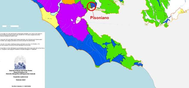
5 Application: Comune di Pisoniano Regio: Lazio Province: Roma Area: 1300 hectares Population: 850 inhabitants New urban plan 5

6 PUCG Required documents the same as bigger cities like Rome for analysis prior to urban planning for SEA First phase of the PUCG process 6
7 Topographic basis Carta Tecnica Regione Lazio (CTR) 1:5000 Available in shp and dwg format by direct request upon charge (reduced fee for local authorities that buy the whole territory) Signed letter, bank transfer, signed permit by regional authority, etc very kind people but quite complicate procedure, even for public authorities Reference system : ED 50 (to be converted to WGS84) 7

8 Analyses on CTR All the elements have localised and represented according to the same reference system and on the CTR basis 8


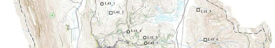
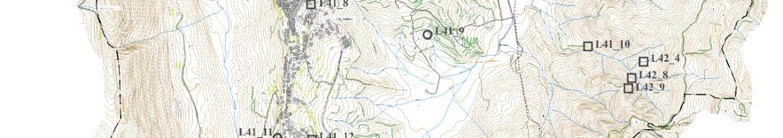


9 Morphology Analyses based on CTR and on data from other sources in literature 9


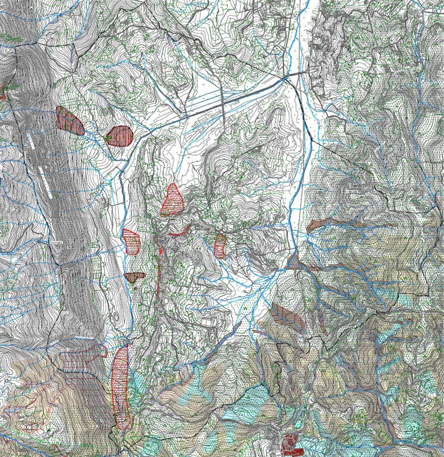
10 PTPR 10

11 PTPR Web consultation available from Regione Lazio dedicated web-site A download area only for pdf version Shp files available for the interested area by request from the local authorities Reference system WGS84 11

12 PTPR 12

13 PTPR localisation of protected cultural areas 13


14 PTPG 14
15 PTPG Web consultation available from Provincia di Roma but only in pdf format (the Province has the gis original file but in such a way that a distribution is not possible) Pdf files with better resolution avaliable for the interested area by request from the local authorities No Reference system Digitalisation of the map has been necessary 15


16 16
17 Hydrogeological risk 17
18 Hydrogeological risk and hydrology Data from 2 different River basin authorities AdB Tevere AdB Liri Garigliano Volturno Some data available in shp format directly form the river basin authority web site (AdB Tevere) Web service available from national geoportal / Ministry for Environment Some data available from Ministry for Environment (by direct inquiry) 18
19 Water - Hydrology 2 districts: Appennino Centrale Appennino Meridionale Sectorial plans Piano di Gestione (della risorsa idrica) PGDAC del Distretto Idrografico Appennino Centrale, Piano di Gestione del rischio di alluvione - PGRAAC del Distretto Idrografico Appennino Centrale Piano di Gestione delle Acque del Distretto Idrografico Appennino Meridionale Piano di Gestione del rischio di alluvione - PGRA del Distretto Idrografico Appennino Meridionale. Piano stralcio per l assetto Idrogeologico Autorità di Bacino Nazionale del Tevere Piano stralcio per l assetto Idrogeologico Rischio frane (PsAI-rF) - Autorità di Bacino Nazionale Liri-Garigliano, Volturno Piano stralcio per l assetto Idrogeologico Rischio idraulico (PsAI-Ri) - Autorità di Bacino Nazionale Liri-Garigliano, Volturno Piano Regionale di Tutela delle Acque (all approved at least after 2010) 19


20 Water - 20


21 Water Difficulties in localisation of single elements 21

22 Air Quality Regional plan Data available from tables and static images At municipality level No particular problems but digital files could have made work easier 22


23 New data Produced information is always geo-localised and related to the same bases Zoning Transport lines e.g. sewage lines 23

24 A particular problem Boundaries 3 official boundaries + 24
25 Evaluation Several situations have been identified: presence of data with relevant metadata and correct reference system (few) presence of digital data without or without relevant metadata but different reference system, that can be: available through web services available through direct contact either for free or with charge (even for a public authorities ) not available in digital format other cases Lot of work that could have been avoided if relevant data were available, at least on the same reference system and basis 25

26 INSPIRE What can INSPIRE do? Continue in its efforts at EU and national level Disseminate knowledge of the principles and infrastructures at the level of public and private technicians that are not INPIRE experts nor common people These are the persons that disseminate data and should be aware of the enormous potential and not jealous of their data 26
27 Conclusions A lot has been done A lot has to be done All administrative levels are important INSPIRE can start to go out of expert circles and EU/national levels 27
28 28
The Process of Spatial Data Harmonization in Italy. Geom. Paola Ronzino
 The Process of Spatial Data Harmonization in Italy Geom. Paola Ronzino ISSUES Geospatial Information in Europe: lack of data harmonization the lack of data duplication of data CHALLENGES Challenge of INSPIRE:
Status of implementation of the INSPIRE Directive 2016 Country Fiches. COUNTRY FICHE Italy
 Status of implementation of the INSPIRE Directive 2016 Country Fiches COUNTRY FICHE Italy Introduction... 1 1. State of Play... 2 1.1 Coordination... 2 1.2 Functioning and coordination of the infrastructure...
LIFE AGROCLIMAWATER GEODATABASE DEVELOPMENT, UPDATE AND MAINTENANCE ACTION C1
 LIFE14 CCA/GR/000389 - AgroClimaWater Promoting water efficiency and supporting the shift towards a climate resilient agriculture in Mediterranean countries Deliverable C1.2: Fully functional Geodatabase
Territorial vulnerability analysis: the case studies
 Territorial vulnerability analysis: the case studies M. C. Treu 1, M. Samakovlija 2 & M. Magoni 2 1 DiAP, 2 CEDAT, Politecnico di Milano Abstract This is the second of three papers presented by the Politecnico
Gis for Land Management: An Overview on Italy
 Gis for Land Management: An Overview on Italy Paola RONZINO, Italy Key words: Cartography, Land Management, Spatial Planning, Urban Renewal, Spatial Information, Environment SUMMARY The introduction of
SDI in Lombardia (Italy(
 SDI in Lombardia (Italy( Italy) Andrea Piccin European SDI Best Practice Awards 2009 - Learning from Best Practices Turin, 26th and 27th November 2009 Lombardia, in Italy, is 4 th Region for territorial
Zagreb Spatial Data Infrastructure. Sanja Batić, APIS IT Split, 14. rujna 2011.
 Zagreb Spatial Data Infrastructure Sanja Batić, APIS IT Split, 14. rujna 2011. Agenda Zagreb Spatial Data Infrastructure - ZIPP Guidelines for further ZIPP Geoportal development Conclusion 1964 The Centre
Estonian approach to implementation of INSPIRE directive. Sulev Õitspuu Head of Bureau of Geoinfosystems Estonian Land Board
 Estonian approach to implementation of INSPIRE directive Sulev Õitspuu Head of Bureau of Geoinfosystems Estonian Land Board 13.06.2016 Contents - INSPIRE coordination in Estonia - INSPIRE implementation
Land Board, NW Services and SDI Tambet Tiits, FRICS
 Land Board, NW Services and SDI Tambet Tiits, FRICS 07.09.2016 200th anniversary of the Struve Geodetic Arc Friedrich Georg Wilhelm Struve and Carl Friedrich Tenner Struve Geodetic Arc The Struve Geodetic
The project, born from an idea of the Provincial College of the Surveyors of Trapani and from the synergy between the administration of Mazara del
 The project, born from an idea of the Provincial College of the Surveyors of Trapani and from the synergy between the administration of Mazara del Vallo, with the Surveyors Professional Organizations :
Demonstration of a local SDI solution with several stakeholders in pilot areas in line with EU best practices
 EU Twinning project for the Agency of Land Relations and Cadaster (ALRC)- Organization, Streamlining and Computerization Process in Mapping in the Republic of Moldova. Demonstration of a local SDI solution
SDI Development in Georgia. Mari Khardziani Head of International Relations Unit National Agency of Public Registry
 SDI Development in Georgia Mari Khardziani Head of International Relations Unit National Agency of Public Registry Kehl, Germany September 5, 2017 2 National Agency of Public Registry Legal Entity of Public
Investigation into the authorities efforts to limit flood and landslide hazards. Presentation at the seminar on Auditing climate change, Copenhagen
 Investigation into the authorities efforts to limit flood and landslide hazards Presentation at the seminar on Auditing climate change, Copenhagen 24.03.2010 324 000 km2 + Arctic islands 4,8 millions inhabitants,
University of Dortmund, Tel.: , Tel.
 IAEG-UGSPLE2014, 122, v1 (major): The use of risk... 1 The use of risk information in spatial planning in Europe: examples from case study sites in Italy and Romania with a focus on flood and landslide
Norwegian spatial data infrastructure supporting disaster risk management Norwegian Mapping Authority
 Norwegian spatial data infrastructure supporting disaster risk management Norwegian Mapping Authority Arvid Lillethun, Norwegian Mapping Authority Land and Poverty 2018 Conference, World Bank 19.-23. March
Ministry of ICT of I.R.IRAN
 The ECO 8/6 mill km 2 10 Slamic countries ~330 mill people Oil, Gas, Industries,Tourism 2 Issue transformation in last decade Problem solving needs more integrated approach More interaction &complexity
THEME 1: Expression of needs and Data Infrastructures Informative references for Ecological Network Marche
 THEME 1: Expression of needs and Data Infrastructures Informative references for Ecological Network Marche Claudio Zabaglia Regione Marche - Project manager Head of Biodiversity, ecological network and
Background to the PFRA European Overview UC10508
 Background to the PFRA European Overview UC10508 The individual Member State Reports reflect the situation as reported by the Member States to the European Commission in 2014 The situation in the MSs may
The Added Value of Geospatial Data in a Statistical Office. Pedro Diaz Munoz Director Sectoral and Regional Statistics EUROSTAT European Commission
 The Added Value of Geospatial Data in a Statistical Office Pedro Diaz Munoz Director Sectoral and Regional Statistics EUROSTAT European Commission Why integrate Responsibility of all the information we
INSPIRE in Sweden.
 INSPIRE in Sweden Swedish National Data Service Established 2008. SND is a service organisation for Swedish research within the Humanities, Social Sciences and Medicine. SND is the Swedish node in an international
The Governance of Land Use
 The Governance of Land Use COUNTRY FACT SHEET SPAIN The planning system Levels of government and their responsibilities Spain is defined by the OECD as a quasi-federal state with 4 levels of government;
Gistat: moving towards a location information management system
 Gistat: moving towards a location information management system (merging geographical, statistical and historical information) Pina Grazia Ticca Marco Ballin Istat - Italy Aguascalientes, Mexico 2-4 December
Lombardy Region Territorial Context and Planning Structures
 Lombardy Region Territorial Context and Planning Structures Carlo Palazzoli RUMORE project manager carlo_palazzoli@regione.lombardia.it 15th May 2018 / RUMORE Third Partner Meeting Lombardy Region in Europe
Compact guides GISCO. Geographic information system of the Commission
 Compact guides GISCO Geographic information system of the Commission What is GISCO? GISCO, the Geographic Information System of the COmmission, is a permanent service of Eurostat that fulfils the requirements
a national geological survey perspective François ROBIDA BRGM (French Geological Survey)
") a national geological survey perspective François ROBIDA BRGM (French Geological Survey) Pre-Conference Seminar on Socio-Economic Value of Geospatial for National and Regional Development 21 August 2017,
a national geological survey perspective François ROBIDA BRGM (French Geological Survey) Pre-Conference Seminar on Socio-Economic Value of Geospatial for National and Regional Development 21 August 2017,
New perspectives in INSPIRE application for environmental protection in Italy. Prof. Ing. Monica Pasca
 New perspectives in INSPIRE application for Prof. Ing. Monica Pasca Italian INSPIRE legislation Legislative Decree January 27, 2010 n. 32 published on March 9, 2010 Transposition of Directive 2007/2/CE
Application of INSPIRE rules to support environmental impact assessment in IPPC(Integrated Pollution Prevention and Control)
") Direzione Ambiente e Difesa del Suolo e della Costa Application of INSPIRE rules to support environmental impact assessment in IPPC(Integrated Pollution Prevention and Control) Inspire Conference Florence
Direzione Ambiente e Difesa del Suolo e della Costa Application of INSPIRE rules to support environmental impact assessment in IPPC(Integrated Pollution Prevention and Control) Inspire Conference Florence
Regione Umbria. ESRI EMEA User Conference 2010 Rome, October 27th 2010
 Direzione Ambiente, Territorio e Infrastrutture Servizio Informatico/Informativo: geografico, ambientale e territoriale ESRI EMEA User Conference 2010 Rome, October 27th 2010 Arch. Ambra Ciarapica, Dott.
IRDAT Fvg, evolving a regional Spatial Data Infrastructure according to INSPIRE
 IRDAT Fvg, evolving a regional Spatial Data Infrastructure according to INSPIRE Tutti i diritti riservati. Proprietà INSIEL SpA. A. Benvenuti, A. Chiarandini Insiel (Italy) M. Lunardis - Friuli Venezia
Disaster Management in Mongolia
 The Third UN-GGIM-AP Plenary Meeting Disaster Management in Mongolia ~Coordination among NGIA & Other Related Organizations and Recommendations~ Bali Indonesia 10 November 2014 Khurelshagai Ayurzana, Director
Progress Report. Flood Hazard Mapping in Thailand
 Progress Report Flood Hazard Mapping in Thailand Prepared By: Mr. PAITOON NAKTAE Chief of Safety Standard sub-beuro Disaster Prevention beuro Department of Disaster Prevention and Mitigation THAILAND E-mail:
SITMUN: Cooperating to Build Local SDIs in the Barcelona Region
 SITMUN: Cooperating to Build Local SDIs in the Barcelona Region Diputació de Barcelona Territory and Sustainability Area Territorial Information Systems Department INSPIRE CONFERENCE Barcelona, September
Evolution and development of National Spatial Data Infrastructure in Republic of Moldova
 Agency for Land Relations and Cadastre of the Republic of Moldova Evolution and development of National Spatial Data Infrastructure in Republic of Moldova Alexandru Morcov Deputy general director ALRC
Upgrade the Datasets in NSDI for Smarter Services with the Cases of China
 Upgrade the Datasets in NSDI for Smarter Services with the Cases of China By Dr. JIANG Jie Dept of GeoInformaiton Service Platform National Geomatics Center of China October 7, 2015 Jeju, Republic of Korea
PLACE-BASED INFORMATION MANAGEMENT FOR ECONOMIC GROWTH ADMINISTRATION OF LAND AFFAIRS, GEODESY AND CARTOGRAPHY
 PLACE-BASED INFORMATION MANAGEMENT FOR ECONOMIC GROWTH ADMINISTRATION OF LAND AFFAIRS, GEODESY AND CARTOGRAPHY 5 October 2012 CONTENTS Current situation of Geospatial information in Mongolia Usage of geospatial
RETA 6422: Mainstreaming Environment for Poverty Reduction Category 2 Subproject
 RETA 6422: Mainstreaming Environment for Poverty Reduction Category 2 Subproject A. Basic Data 1. Subproject Title: Poverty-Environment Mapping to Support Decision Making 2. Country Director: Adrian Ruthenberg
Tomas Mildorf, Karel Janecka University of West Bohemia in Pilsen Czech Republic
 European Network of Best Practices for Interoperability of Spatial Planning Information Tomas Mildorf, Karel Janecka mildorf@centrum.cz, kjanecka@kma.zcu.cz University of West Bohemia in Pilsen Czech Republic
Topic 2 Biodiversity information flow in different investments: A case study in Marche Region Lorenzo Federiconi Alessandro Cartuccia Marche Region
 Topic 2 Biodiversity information flow in different investments: A case study in Marche Region Lorenzo Federiconi Alessandro Cartuccia Marche Region BID-REX Interregional thematic workshop - IMPROVING DATA
March 2007 The Survey Department of Sri Lanka
 Contribution of Survey Department of Sri Lanka for Mitigation of Disasters in Sri Lanka K.A.U.N.Kasthuri Deputy Surveyor General (Information Technology) March 2007 The Survey Department of Sri Lanka 1
INTEROPERABILITY AND SPATIAL PLANNING
 INSPIRE Conference 2011 Edimburgh, July 1st, 2011 INTEROPERABILITY AND SPATIAL PLANNING Franco Vico AMFM GIS Italia Flavio Camerata - DipSU, Università Roma Tre European Network of Best Practices for Interoperability
Interoperability of Spatial Planning Data
 INSPIRE Conference 2010, Krakow, Poland Interoperability of Spatial Planning Data European Network of Best Practices for Interoperability of Spatial Planning Information Tomas Mildorf mildorf@centrum.cz
Riga. Riga City Planning Region. Legal framework
 Riga http://www.rpr.gov.lv/ Riga City Planning Region Riga Planning Region as a territory is situated in the central part of Latvia, and its centre is Riga - the capital of Latvia. Riga is internationally
Implementing INSPIRE in Sweden
 Implementing INSPIRE in Sweden Christina Wasström NSDI-unit, Lantmäteriet Christina.wasstrom@lm.se Standards Cooperation Metadata Competence Infrastructure for Geodata Legal Framework Portal Services Geodata
A Method for Mapping Settlement Area Boundaries in the Greater Golden Horseshoe
 A Method for Mapping Settlement Area Boundaries in the Greater Golden Horseshoe Purpose This paper describes a method for mapping and measuring the lands designated for growth and urban expansion in the
2013 Cartographic Country Report Uruguay **
 ADVANCE UNEDITED VERSION UNITED NATIONS _ STATISTICS DIVISION E/CONF.103/IP.5 Tenth United Nations Regional Cartographic Conference for the Americas New York, 19-23, August 2013 Item 6(b) of the provisional
Land Use Planning and Agriculture: Austrian Experiences and Challenges I
 Land Use Planning and Agriculture: Austrian Experiences and Challenges I SULANET Summer School 2016 Walter Seher BOKU Vienna 1 Land Use Planning and Agriculture 2 Land Use Planning and Agriculture Agriculture
INSPIRE implementation in the Turkish Ministry of Environment and Urbanization Producing and Publishing Environmental Data
 INSPIRE implementation in the Turkish Ministry of Environment and Urbanization Producing and Publishing Environmental Data Ezgi Sarmusak Urban Planner, MoEU Sibel Süer Toybıyık - Assistant Expert, MoEU
Study Visit University of Applied Sciences Utrecht Netherlands
 Study Visit University of Applied Sciences Utrecht Netherlands Directorate-General for Territorial Development Lisbon 1 April 2014 1 Agenda Presentation Cadastre Department Surveying / Geodesy Department
The UN-GGIM: Europe core data initiative to encourage Geographic information supporting Sustainable Development Goals Dominique Laurent, France
 INSPIRE conference Strasbourg 6 September 2017 The UN-GGIM: Europe core data initiative to encourage Geographic information supporting Sustainable Development Goals Dominique Laurent, France Introduction
The story of sharing environmental data
 The story of sharing environmental data Kallio, Pyhälahti, Harju, Teiniranta, Lahtinen, Finnish Environment Institute SYKE OKFestival, Finnish Open Data, 18. Sep 2012 Contents Call for environmental knowledge
RESOURCES DEVELOPMENT GEOSPATIAL DATA USING THE DIGITAL TOPOGRAPHIC PLAN OF ROMANIA- TOPRO5
 C. C-tin Muşat, F. M. Brebu, A. C. Bălă, I. S. Herban Resources Development Digital Geospatial Data Using the Digital Topographic Plan of Romania - TOPRO5 RESOURCES DEVELOPMENT GEOSPATIAL DATA USING THE
16540/14 EE/cm 1 DG E 1A
 Council of the European Union Brussels, 5 December 2014 (OR. en) 16540/14 ENV 965 CULT 139 NOTE From: To: Subject: General Secretariat of the Council Delegations Charter of Rome on Natural and Cultural
HARMONIZING AND INTEGRATING OF THREE LEVELS OF SPATIAL PLANNING DATABASES FOR THE MUNICIPALITY OF VITI IN KOSOVA
 Bashkim IDRIZI, Valbone SULEJMANI HARMONIZING AND INTEGRATING OF THREE LEVELS OF SPATIAL PLANNING DATABASES FOR THE MUNICIPALITY OF VITI IN KOSOVA 4-8 September 2017; Kehl and Strasbourg Overview: Preface
GEOGRAPHICAL NAMES AS PART OF THE GLOBAL, REGIONAL AND NATIONAL SPATIAL DATA INFRASTRUCTURES
 GEOGRAPHICAL NAMES AS PART OF THE GLOBAL, REGIONAL AND NATIONAL SPATIAL DATA INFRASTRUCTURES Željko HEĆIMOVIĆ, Željka JAKIR, Zvonko ŠTEFAN, Danijela KUKIĆ zeljko.hecimovic@cgi.hr, zeljka.jakir@cgi.hr,
SDI Implementation at the Local
 SDI Implementation at the Local Administration Level of Germany Hartmut Müller and Stephan von St. Vith FIG Working Week 2009 Surveyors Key Role in Accelerated Development, Eilat, Israel, 3-8 May 2009
IDEBarcelona: Cooperating for a Smart Region Infrastructure
 IDEBarcelona: Cooperating for a Smart Region Infrastructure Marta Codinachs Serra Diputació de Barcelona Territory and Sustainability Area Territorial Information Systems Department SMART CITY EXPO WORLD
Turkey s National SDI Implementation
 Onur PAŞAOĞULLARI Head of Department Turkey s National SDI Implementation Presentation Plan NSDI Background General Directorate of Geographic Information Systems NSDI Project INSPIRE Directive Urban Information
Evolution of the Po Delta, Italy
 Evolution of the Po Delta, Italy Albert Kettner & James Syvitski, Charles Vörösmarty Dynamics and Vulnerability of River Delta Systems workshop September, 2007 Outline 21,000 years ago Effects of the ever
EO Information Services. Assessing Vulnerability in the metropolitan area of Rio de Janeiro (Floods & Landslides) Project
 Project") EO Information Services in support of Assessing Vulnerability in the metropolitan area of Rio de Janeiro (Floods & Landslides) Project Ricardo Armas, Critical Software SA Haris Kontoes, ISARS NOA World
EO Information Services in support of Assessing Vulnerability in the metropolitan area of Rio de Janeiro (Floods & Landslides) Project Ricardo Armas, Critical Software SA Haris Kontoes, ISARS NOA World
Geospatial information in e-government services for environmental permiting the eenviper project case study
 UDC: 007:528.9]:004; 007:912]:004; 004.92 DOI:10.14438/gn.2013.20 Geospatial information in e-government services for environmental permiting the eenviper project case study Dragutin PROTIĆ 1*, Ivan NESTOROV
Between legislation and consensus how do we INSPIRE Denmark?
 Between legislation and consensus how do we INSPIRE Denmark? Olav Eggers Spatial Data Infrastructure Division Danish Ministry of the Environment National Survey and Cadastre (KMS), Denmark INSPIRE Contact
INSPIRE Basics. Vlado Cetl European Commission Joint Research Centre. https://ec.europa.eu/jrc/
 INSPIRE Basics Vlado Cetl European Commission Joint Research Centre https://ec.europa.eu/jrc/ Serving society Stimulating innovation Supporting legislation Outline SDI? Why European SDI? INSPIRE Policy
The Infrastructure for Spatial Information in the European Community vs. regional SDI: the shortest way for reaching economic and social development
 The Infrastructure for Spatial Information in the European Community vs. regional SDI: the shortest way for reaching economic and social development Mauro Salvemini EUROGI PRESIDENT Professor at Sapienza
INSPIRATION results and benefits for the Agency for Real Estate Cadastre
 JOINT RESEARCH CENTER - E&I WORKSHOP INSPIRATION results and benefits for the Agency for Real Estate Cadastre Sonja Dimova, state advisor AGENCY FOR REAL ESTATE CADASTRE REPUBLIC OF MACEDONIA Wednesday,
Disaster Management in Republic of Korea
 The Third UN-GGIM-AP Plenary Meeting Disaster Management in Republic of Korea ~Coordination among NGIA & Other Related Organizations and Recommendations~ Bali Indonesia 10 November 2014 Sanghoon Lee, Ph.D.
EARTH OBSERVATION SERVICES IN REPUBLIC OF MOLDOVA
 EARTH OBSERVATION SERVICES IN REPUBLIC OF MOLDOVA Vasile ALCAZ 1 Ion APOSTOL 2 1 Institute of Geology and Seismology Moldavian Academy of Sciences 2 Ministry of Environment and Natural Resources Republic
GIS Geographical Information Systems. GIS Management
 GIS Geographical Information Systems GIS Management Difficulties on establishing a GIS Funding GIS Determining Project Standards Data Gathering Map Development Recruiting GIS Professionals Educating Staff
The Swedish National Geodata Strategy and the Geodata Project
 The Swedish National Geodata Strategy and the Geodata Project Ewa Rannestig, Head of NSDI Co-ordination Unit, Lantmäteriet, ewa.rannstig@lm.se Ulf Sandgren, Project Manager Geodata Project, Lantmäteriet,
Natura 2000 and spatial planning. Executive summary
 Natura 2000 and spatial planning Executive summary DISCLAIMER The information and views set out in this study are those of the author(s) and do not necessarily reflect the official opinion of the Commission.
Plan4all (econtentplus project)
") Plan4all (econtentplus project) Karel CHARVAT 1, Tomáš MILDORF 2 1 Help service remote sensing, Ltd., Černoleská 1600, 256 01 Benešov u Prahy, Czech Republic charvat@bnhelp.cz 2 Department of Mathematics
Plan4all (econtentplus project) Karel CHARVAT 1, Tomáš MILDORF 2 1 Help service remote sensing, Ltd., Černoleská 1600, 256 01 Benešov u Prahy, Czech Republic charvat@bnhelp.cz 2 Department of Mathematics
Margarita Stancheva Hristo Stanchev & Robert Young 2. MEDCOAST JUBILEE WORKSHOP May 2015, Iberotel Sarigerme Park, Dalaman, Turkey
 Margarita Stancheva Hristo Stanchev & Robert Young 2 INTRODUCTION: Bulgarian Black Sea coast INTRODUCTION: Increasing pressure on Bulgarian coastal zone In 2011, of the 7 364 570 people that lived in Bulgaria,
The regional early warning system for rainfall-induced landslides operating in Campania (Italy): performance evaluation of two warning strategies
: performance evaluation of two warning strategies") 1st IMEKO TC-4 International Workshop on Metrology for geotechnics 17-18 March 2016, Benevento (Italy) The regional early warning system for rainfall-induced landslides operating in Campania (Italy): performance
1st IMEKO TC-4 International Workshop on Metrology for geotechnics 17-18 March 2016, Benevento (Italy) The regional early warning system for rainfall-induced landslides operating in Campania (Italy): performance
Adding value to Copernicus services with member states reference data
 www.eurogeographics.org Adding value to Copernicus services with member states reference data Neil Sutherland neil.sutherland@os.uk GIS in the EU 10 November 2016 Copyright 2016 EuroGeographics 61 member
Status of implementation of the INSPIRE Directive 2016 Country Fiches. COUNTRY FICHE Estonia
 Status of implementation of the INSPIRE Directive 2016 Country Fiches COUNTRY FICHE Estonia Introduction... 1 1. State of Play... 2 1.1 Coordination... 2 1.2 Functioning and coordination of the infrastructure...
Utilization and Provision of Geographical Name Information on the Basic Map of Japan*
 UNITED NATIONS WORKING PAPER GROUP OF EXPERTS NO. 1/9 ON GEOGRAPHICAL NAMES Twenty-eight session 28 April 2 May 2014 Item 9 of the Provisional Agenda Activities relating to the Working Group on Toponymic
Land Use in the context of sustainable, smart and inclusive growth
 Land Use in the context of sustainable, smart and inclusive growth François Salgé Ministry of sustainable development France facilitator EUROGI vice president AFIGéO board member 1 Introduction e-content+
EUROPEAN COMPUTER DRIVING LICENCE. GIS Cartography. Syllabus
 EUROPEAN COMPUTER DRIVING LICENCE GIS Cartography Syllabus Purpose This document details the syllabus for ECDL GIS Module 1 Cartography. The syllabus describes, through learning outcomes, the knowledge
Sustainable and Harmonised Development for Smart Cities The Role of Geospatial Reference Data. Peter Creuzer
 Sustainable and Harmonised Development for Smart Cities The Role of Geospatial Reference Data Peter Creuzer 1. Introduction - Smart Cities and Geodata 2. Geodata in Germany 3. Examples 4. Data and Service
Appropriation Directions for 2007
 INSPIRE in Sweden An Important Part of the National Geodata Strategy Monica Lagerqvist Nilsson Appropriation Directions for 2007 A commission to investigate the necessity to adjust the Swedish legislation
GIS Changing the World GIS Day November 15, 2017
 + GIS Changing the World GIS Day November 15, 2017 + Growing Up On The Farm 3 Geographic Information in DNR A 75 year history of mapping and GIS. Forest type map from 1944. State of Washington - Division
BIM and INSPIRE, for a better integration of built infrastructures in their environment : the MINnD project
 BIM and INSPIRE, for a better integration of built infrastructures in their environment : the MINnD project François ROBIDA Christophe CASTAING Strasbourg, > 1 8 septembre 2017 ABOUT BIM Building Information
National Adaptation Geo-information System (NAGiS) project in Hungary
 project in Hungary") National Adaptation Geo-information System (NAGiS) project in Hungary Mr. Péter Kajner Hungarian Mining and Geological Survey (MBFSZ) National Adaptation Center Department CGE webinar: Geo-information
National Adaptation Geo-information System (NAGiS) project in Hungary Mr. Péter Kajner Hungarian Mining and Geological Survey (MBFSZ) National Adaptation Center Department CGE webinar: Geo-information
INSPIRE implementation in Portugal: the operational approach
 INSPIRE implementation in Portugal: the operational approach REIS, Rui; SANTOS, Ana Sofia; FONSECA, Alexandra; SILVA, Henrique; GOMES, Ana Luisa; FURTADO, Danilo; GEIRINHAS, João rui.reis@igeo.pt AGENDA
Harmonizing spatial databases and services at local and regional level
 Harmonizing spatial databases and services at local and regional level A. Ionita 1, M. Caian 2, V. Vassilev 3, V. Craciunescu 2, I. Nedelcu 4 1 Research Institute for Artificial Intelligence, Bucuresti,
Funding systems used in Mexico to support institutional arrangements: INEGI case
 Funding systems used in Mexico to support institutional arrangements: INEGI case Sistemas de financiamiento usados en México, para soportar arreglos institucionales: Caso INEGI United Nations Committee
SWEDISH SDI DEVELOPMENT & IMPLEMENTATION OF INSPIRE
 SWEDISH SDI DEVELOPMENT & IMPLEMENTATION OF INSPIRE Christina Wasström, Lantmäteriet, 801 82 Gävle, Sweden, christina.wasstrom@lm.se ABSTRACT The Swedish Government and Parliament has given Lantmäteriet
Establishing the National Spatial Data Infrastructure (NSDI) for Norway a joint effort by many stakeholders SPATIAL DATA FOR BENEFIT OF THE SOCIETY
 for Norway a joint effort by many stakeholders SPATIAL DATA FOR BENEFIT OF THE SOCIETY") Establishing the National Spatial Data Infrastructure (NSDI) for Norway a joint effort by many stakeholders SPATIAL DATA FOR THE BENEFIT OF SOCIETY OUTLINE Political background Norway digital - The Norwegian
Establishing the National Spatial Data Infrastructure (NSDI) for Norway a joint effort by many stakeholders SPATIAL DATA FOR THE BENEFIT OF SOCIETY OUTLINE Political background Norway digital - The Norwegian
Turkey National Report
 UNITED NATIONS Working Paper GROUP OF EXPERTS ON No. 26 GEOGRAPHICAL NAMES Twenty-third Session Vienna, 28 March 4 April 2006 Item 5 of the Provisional Agenda: Reports of the division Turkey National Report
National Spatial Data Infrastructure International workshop 9 th June, 2015 Terelj Hotel, Mongolia
 1 st session: NSDI policy, planning and the legal framework Formation of NSDI policy and legal framework in Mongolia Khurelshagai Ayurzana, Director General, Administration of Land Affairs, Geodesy and
E-Government and SDI in Bavaria, Germany
 135 E-Government and SDI in Bavaria, Germany Wolfgang STOESSEL, Germany Key words: GDI-BY, Bavaria, Spatial Data Infrastructure SUMMARY Spatial Data Infrastructure (SDI) is an important part of the e-government
Spatially enabling e-government through geo-services
 Spatially enabling e-government through geo-services Mauro Salvemini EUROGI PRESIDENT Professor at Sapienza Università di Roma (IT) 1 About the presentation Few information about Eurogi ; Some essential
Aterno River Contract. Intermediate Analysis
 Aterno River Contract Intermediate Analysis Aterno - Pescara River THE PATH OF THE RIVER Aterno River F.Raiale Pescara T.Raio L Aquila F.Vera F.Aterno Avezzano R.Scuro Sulmona F.Vella F.Sagittario confine
Geoservices in Hamburg
 Geoservices in Hamburg Dr.-Ing. Winfried Hawerk Freie und Hansestadt Hamburg Landesbetrieb Geoinformation und Vermessung FIG Commission 7 Symposium Celje 16 May 2006 Hamburg and the Metropolitan Area Hamburg
5.2. Historic heritage. Photo: Vaughan Homestead, Long Bay Regional Park, Auckland. (Source: ARC). Historic heritage
. Historic heritage") Photo: Vaughan Homestead, Long Bay Regional Park, Auckland. (Source: ARC). 274 Hazards and heritage Contents 5.2 Introduction 276 monitoring programmes 276 The state of historic heritage 277 Heritage items
Photo: Vaughan Homestead, Long Bay Regional Park, Auckland. (Source: ARC). 274 Hazards and heritage Contents 5.2 Introduction 276 monitoring programmes 276 The state of historic heritage 277 Heritage items
Oman NSDI Supporting Economic Development. Saud Al-Nofli Director of Spatial Data Directorate General of NSDI, NCSI
 Oman NSDI Supporting Economic Development 2017 Saud Al-Nofli Director of Spatial Data Directorate General of NSDI, NCSI "It s critical to make correct decisions the first time to optimize the Investments
CLICK HERE TO KNOW MORE
 CLICK HERE TO KNOW MORE GeoSpace for Singapore s Whole-of-Government Data Sharing Asia GeoSpatial Forum 17 19 Oct 2011 Lee Kim Haw Singapore Land Authority Introducing Singapore Land Authority Limited
UN-GGIM: Europe ExCom 1 June 2016 Francfort Work Group A «Core Data» Status and Progress François Chirié, France
 UN-GGIM: Europe ExCom 1 June 2016 Francfort Work Group A «Core Data» Status and Progress François Chirié, France Plan The Core Data Scope Deliverable 7-8 June 2016 WGA workshop to investigate work plans
EXPERT ANALYSIS ON GEOGRAPHICAL SPECIFICITIES
 EXPERT ANALYSIS ON GEOGRAPHICAL SPECIFICITIES Mountains, Islands and Sparsely Populated Areas Dr. Gilda Carbone 9 Oct 2018 Objectives: to gather basic information from relevant programming documents (PAs,
TWG BU State of Play November 2010
 TWG BU State of Play November 2010 TWG BU members General methodology Existing data Use cases User requirements Existing standards Modelling approach Next steps Plan of presentation TWG BU members TWG
Version 1.1 GIS Syllabus
 GEOGRAPHIC INFORMATION SYSTEMS CERTIFICATION Version 1.1 GIS Syllabus Endorsed 1 Version 1 January 2007 GIS Certification Programme 1. Target The GIS certification is aimed at: Those who wish to demonstrate