Data fusion techniques for real-time mapping of urban air quality
|
|
|
- Felix Peters
- 6 years ago
- Views:
Transcription

1 ESA eo open science October 2015, Frascati, Italy Making sense of crowdsourced observations: Data fusion techniques for real-time mapping of urban air quality Philipp Schneider 1 Nuria Castell 1 William A. Lahoz 1 and the entire CITI-SENSE team 1 NILU Norwegian Institute for Air Research

2 Air pollution is the top environmental risk factor for premature death


3 In 2011, premature deaths in Europe were attributed to particulate matter in the air The Guardian


4 Traditional Air Quality Monitoring Is there another way? Large Complex High-maintenance Expensive Very sparse Bidgee


5 There might be


6 Static observation network AQMesh by Geotech Wireless air quality monitor Measures a variety of pollutants: NO, NO 2, O 3, CO, SO 2, PM 10, PM 2.5, as well as temperature, humidity, and pressure Compares reasonably well with reference equipment (but dependent on species)


7 Point-based observations: The problem How do we get from this: To this: CITI-SENSE app: Android-based mobile app for real-time AQ monitoring

 creates a")
 correcting the")


8 Data fusion: Basic Premise DATA FUSION Observations x Modelling results or other auxiliary data Data fusion (as a subset of data assimilation) creates a valueadded product by a) Interpolating the observations in an objective way b) correcting the model estimates with true observations ? x Data fusion method used here provides a combined concentration field by regressing the observations against model data and spatially interpolating the residuals Combined map


9 Data fusion for CITI-SENSE A static basemap is created for each location and each species of interest to show the longterm spatial patterns This basemap is then modified according to the observations made by the static Geotech sensors This is essentially a locationdependent level-shift of the basemap The final result are hourly maps with the current best guess for the NO 2 /PM 10 /PM 2.5 concentration field at all CITI- SENSE locations Static basemap (for each species and location) Obs 15:00 CET Obs 16:00 CET Obs 17:00 CET Fused 15:00 CET Fused 16:00 CET Fused 17:00 CET Basemap: Provides information about general spatial patterns Geotech observations: Provide information about current state of atmosphere at a few sampling locations Fused map: Value-added product providing a best guess of current state of atmosphere for the entire domain

, 1 28, doi:10.3389/fenvs.2014.00016.")
10 Data fusion methodology Data fusion is a subset of data assimilation techniques (Lahoz and Schneider, 2014) Uses geostatistical framework Analysis performed entirely in log-space Universal kriging approach Spatial interpolation guided by proxy Explicit automated modelling of spatial autocorrelation Lahoz, W. A., and P. Schneider (2014), Data assimilation: making sense of Earth Observation, Front. Environ. Sci., 2(16), 1 28, doi: /fenvs Theoretical model of spatial autocorrelation Using simple spatial interpolation Using data fusion with spatial proxy

11 Modelling of the basemaps Can be nearly any spatially exhaustive dataset that is related to the observation Best to use are urban-scale dispersion models Alternatively concentration map created through LUR modelling We use the EPISODE model Three-dimensional, combined Eulerian/Lagrangian air pollution dispersion model, developed at NILU Combined modelling and postprocessing approach to obtain basemaps at m spatial resolution High-resolution map of NO 2 in Oslo from the EPISODE dispersion model. These kind of maps are ideally suited as a spatially distributed auxiliary dataset.

12 Receptor-point based downscaling of the gridded EPISODE output

13 Example basemaps for NO 2 Schneider et al. (2015). Making sense of crowdsourced observations. EGU General Assembly 2015, Session ESSI1.10/SSS0.26, 15 April 2015, Vienna, Austria

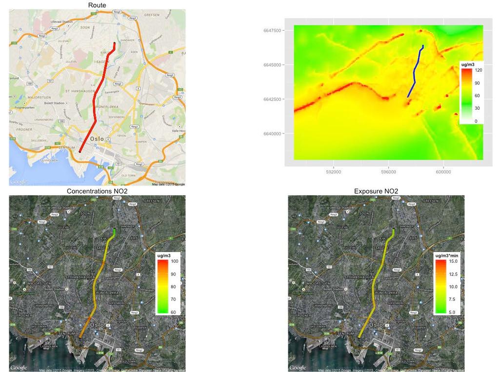
14 A fusion example for Oslo

15 Typical example of a data fusion-based surface concentration field of NO 2 for Oslo, Norway, at 100 m spatial resolution.

16 Validation against Truth Validation sites are randomly selected throughout the image. Concentration values at these sites can be extracted from the truth, the basemap, and the fused result and compared. Example 1: Basemap overestimates truth Example 2: Basemap underestimates truth This shows that the method can predict the true concentration field quite well even in areas where no observations are available.


17 Data fusion of mobile measurements of Black Carbon
 Downscaling of the S5P products to higher spatial resolution using the fused map as proxy for spatial patterns")
18 Applications for Sentinel-5P High-resolution urban air quality maps based on the combination of crowdsourced observations and model data provides sub-pixel information for Sentinel-5P Could be used for: 7 km by 7 km grid of Sentinel-5P products for atmospheric composition Validation/verification of S5P data (e.g. NO 2 ) Downscaling of the S5P products to higher spatial resolution using the fused map as proxy for spatial patterns
19 Conclusions We developed a technique for merging point-based crowdsourced observations of air quality with model information Geostatistics-based: Builds upon decades of experience; best linear unbiased estimator; provides uncertainty estimates Fully automated implementation: Can be run operationally in real time with large datasets Provides a much more realistic estimate of true concentration field than observations or model data alone Realistic high-resolution near real-time concentration fields in urban areas for the first time allow for personalized air quality information How much particulate matter will I breathe in if I ride my bike from home to work right now? What route to work is the least polluted/healthiest? In future, the resulting up-to-date concentration fields could be used for validation and/or downscaling of Sentinel-5P products Not just for air quality: Methodology is useful for most crowdsourcing applications where point observations need to be combined with model data (or other auxiliary information) A first step towards making sense of highly distributed observations in the age of crowdsourcing, Citizen Science, ubiquitous sensing, and Big Data


20 ESA eo open science October 2015, Frascati, Italy Thank you for your attention! Contact: Philipp Schneider
21 Extra Slides


22 The CITI-SENSE project Collaborative Project funded by FP7-ENV project partners from 12 countries (Europe, South Korea, and Australia) Objective: Development of sensor-based Citizen s Observatories for improving urban quality and for empowering citizens to Contribute to and participate in environmental governance Support and influence community and policy priorities and associated decision making Contribute to the Global Earth Observation System of Systems (GEOSS) Data Fusion


23 Observations There are many aspects to CITI-SENSE Air quality observations using static and mobile sensor nodes Indoor environment in schools Public Spaces Here we focus on a network of static sensor nodes for air quality that are being deployed in various cities throughout Europe Measuring the major air pollutants Mounted at stakeholder s premises

24 Towards personal exposure estimates There are two alternative ways for accomplishing personalized exposure/dose estimates Approach 1: Direct use of sensors People move through the urban environment with portable sensors measuring concentrations Approach 2: Indirect use of sensors Sensor data is used with model info and data fusion techniques to provide up-to-date air quality maps for the city -> these maps are then used to estimate exposure along a given track

25 Sensor-based exposure and dose

26

 and the inhaled")


 2.")
 3.")
27 Heart rate -> Dose If we know the subject s hear rate we can compute the inhalation rate (ventilation) and the inhaled dose Heart rate can either be Inhaled dose = Concentration Ventilation Duration Total PM 10 dose: 36.5 µg 1. Measured by a heart rate monitor (mostly Approach 1) 2. Derived from accelerometer data (Approach 1+2) 3. Estimated by activity (mostly Approach 2)
Integrating air quality information from multiple sources
 Integrating air quality information from multiple sources Joost Wesseling (RIVM) Philipp Schneider (NILU) Why AQ sensors? Citizens/NGO s Local authorities National level Citizen Science has a long history,
Predicting Long-term Exposures for Health Effect Studies
 Predicting Long-term Exposures for Health Effect Studies Lianne Sheppard Adam A. Szpiro, Johan Lindström, Paul D. Sampson and the MESA Air team University of Washington CMAS Special Session, October 13,
Ensemble based probabilistic forecasting of air quality in Oslo and Rotterdam
 Ensemble based probabilistic forecasting of air quality in Oslo and Rotterdam Sam-Erik Walker, Bruce Rolstad Denby, Núria Castell Balaguer NILU - Norwegian Institute for Air Research 4 th IWAQFR, WMO,
Let's Make Our Cities Breathable BECAUSE CLEAN AIR BELONGS TO EVERYONE.
 Let's Make Our Cities Breathable BECAUSE CLEAN AIR BELONGS TO EVERYONE. Clean Air is a Human Right that Everyone Should be Entitled to Making cities more breathable starts by measuring, analyzing and understanding
Regional services and best use for boundary conditions
 Regional services and best use for boundary conditions MACC-III User Workshop Roma, 11 May 2015 Virginie Marécal (Météo-France) Laurence Rouïl (INERIS) and the MACC regional consortium Regional services
Using sensor data and inversion techniques to systematically reduce dispersion model error
 Using sensor data and inversion techniques to systematically reduce dispersion model error D. J. Carruthers 1, A. L. Stidworthy 1, D. Clarke 2, K.J. Dicks 3, R. L. Jones 4,I. Leslie 5, O. A. M. Popoola
Decision Support Part 1: Tools to aid travel planning
 Decision Support Part 1: Tools to aid travel planning Decision Support: Tools to Aid Travel Planning Decision support systems are so much more than simply saying when to plow and how much chemical to apply.
Environmental quality modeling
 Environmental quality modeling Air quality management modeling AIRQUIS Water quality management modeling WATERQUIS N:\adm\arkiv\overhead\2006\CEE\Yale-9.ppt 1 An Integrated Air Quality Managament System
Earth Observations as a Tool To Achieve Sustainable Development Goals
 The image part with relationship ID rid3 was not found in the file. 16/10/2017 Earth Observations as a Tool To Achieve Sustainable Development Goals LI Jing, China GEO On behalf of the Group on Earth Observations
AIRNow and AIRNow-Tech
 AIRNow and AIRNow-Tech Dianne S. Miller and Alan C. Chan Sonoma Technology, Inc. Petaluma, California Presented to the National Tribal Forum Spokane, Washington June 15, 2011 910216-4140 Outline Overview
Air quality monitoring reinvented. Helsinki Metropolitan Air Quality Testbed HAQT
 Air quality monitoring reinvented Helsinki Metropolitan Air Quality Testbed HAQT Air Pollution: Single Biggest Environmental Health Risk Inhaling air pollution takes away at least 1-2 years of a typical
New COST Action: Towards a European Network on Chemical Weather Forecasting and Information Systems
 New COST Action: Towards a European Network on Chemical Weather Forecasting and Information Systems Proposer: Mikhail Sofiev Finnish Meteorological Institute Historical background EUMETNET Workshop on
Sensor Networks: Data Processing for Improved Spatial and Temporal Resolution
 The views, opinions, and observations expressed in this article are of the authors and are not necessarily that of the EPA. Sensor Networks: Data Processing for Improved Spatial and Temporal Resolution
The new challenge of community-based environmental monitoring and information systems: the Citizens Obsrevatories Tito Scalo (PZ) 13 July 2016
 13 July 2016") The new challenge of community-based environmental monitoring and information systems: the Citizens Obsrevatories Tito Scalo (PZ) 13 July 2016 Involving citizens in environmental monitoring and awareness:
The new challenge of community-based environmental monitoring and information systems: the Citizens Obsrevatories Tito Scalo (PZ) 13 July 2016 Involving citizens in environmental monitoring and awareness:
Modeling of Atmospheric Effects on InSAR Measurements With the Method of Stochastic Simulation
 Modeling of Atmospheric Effects on InSAR Measurements With the Method of Stochastic Simulation Z. W. LI, X. L. DING Department of Land Surveying and Geo-Informatics, Hong Kong Polytechnic University, Hung
SDG s and the role of Earth Observation
 SDG s and the role of Earth Observation Christian Heipke IPI - Institute for Photogrammetry and GeoInformation Leibniz Universität Hannover Germany Secretary General, ISPRS 1. No Poverty 2. Zero Hunger
International publications on measuring nanoparticles with the portable testo DiSCmini particle counter.
 Testo Book of Abstracts International publications on measuring nanoparticles with the portable testo DiSCmini particle counter. www.testo-particle.com testo DiSCmini Great insights into the world of the
NOAA s Air Quality Forecasting Activities. Steve Fine NOAA Air Quality Program
 NOAA s Air Quality Forecasting Activities Steve Fine NOAA Air Quality Program Introduction Planned Capabilities Initial: 1-day 1 forecast guidance for ozone Develop and validate in Northeastern US September,
How to shape future met-services: a seamless perspective
 How to shape future met-services: a seamless perspective Paolo Ruti, Chief World Weather Research Division Sarah Jones, Chair Scientific Steering Committee Improving the skill big resources ECMWF s forecast
Statistical and epidemiological considerations in using remote sensing data for exposure estimation
 Statistical and epidemiological considerations in using remote sensing data for exposure estimation Chris Paciorek Department of Biostatistics Harvard School of Public Health Collaborators: Yang Liu, Doug
Concept note. High-Level Seminar: Accelerating Sustainable Energy for All in Landlocked Developing Countries through Innovative Partnerships
 Concept note High-Level Seminar: Accelerating Sustainable Energy for All in Landlocked Developing Countries through Innovative Partnerships Date: 24 and 25 October 2016 Venue: Conference Room C3, Vienna
Modelling air pollution and personal exposure in Bangkok and Mexico City using a land use regression model
 Modelling air pollution and personal exposure in Bangkok and Mexico City using a land use regression model GIMA Master s thesis February 2016 Author: Patrick van den Ende Supervisors: Dr. D. Karssenberg
Abstract A statistical method based on adjustments of spatial source oriented structure functions to observed concentration values is presented.
 A stochastic receptor model based on source oriented structure functions K.E. Gr0nskei, S.-E. Walker Norwegian Institute for Air Research, P.O. Box 100, n Airway Abstract A statistical method based on
A Hybrid ARIMA and Neural Network Model to Forecast Particulate. Matter Concentration in Changsha, China
 A Hybrid ARIMA and Neural Network Model to Forecast Particulate Matter Concentration in Changsha, China Guangxing He 1, Qihong Deng 2* 1 School of Energy Science and Engineering, Central South University,
ALASKA ITS. Vehicles and Observations in the cloud
 ALASKA ITS Vehicles and Observations in the cloud 1 YOUR PRESENTERS Wilf Nixon, Salt Institute Mark DeVries, Vaisala Dan Schacher, ADOT&PF 2 Today s Agenda A Cloud Based Overview connected and autonomous
PART A Project summary
 PART A Project summary A.1 Project identification Project title Project acronym Name of the lead partner organisation in English Specific objective Demonstrattion AF DAF Partner 1.1. Improving innovation
Diagnosing New York City s Noises with Ubiquitous Data
 Diagnosing New York City s Noises with Ubiquitous Data Dr. Yu Zheng yuzheng@microsoft.com Lead Researcher, Microsoft Research Chair Professor at Shanghai Jiao Tong University Background Many cities suffer
Climate Risk Visualization for Adaptation Planning and Emergency Response
 Climate Risk Visualization for Adaptation Planning and Emergency Response NCR Flood Fact Finding Workshop Ricardo Saavedra ricardo@vizonomy.com Social Media, Mobile, and Big Data St. Peter s Basilica,
Air Quality Modelling for Health Impacts Studies
 Air Quality Modelling for Health Impacts Studies Paul Agnew RSS Conference September 2014 Met Office Air Quality and Composition team Paul Agnew Lucy Davis Carlos Ordonez Nick Savage Marie Tilbee April
A REAL-TIME OPERATIONAL FORECAST MODEL FOR METEOROLOGY AND AIR QUALITY DURING PEAK AIR POLLUTION EPISODES IN OSLO, NORWAY
 A REAL-TIME OPERATIONAL FORECAST MODEL FOR METEOROLOGY AND AIR QUALITY DURING PEAK AIR POLLUTION EPISODES IN OSLO, NORWAY ERIK BERGE 1, SAM-ERIK WALKER 2, ASGEIR SORTEBERG 1,MOTHEI LENKOPANE 2, STEINAR
WMO Guide on Integrated Urban Weather, Environment and Climate Services for Cities (IUWECS) Hong Kong- an experience from a high-density city
 Hong Kong- an experience from a high-density city") WMO Guide on Integrated Urban Weather, Environment and Climate Services for Cities (IUWECS) Hong Kong- an experience from a high-density city Dr. Chao REN Associate Professor School of Architecture The
WMO Guide on Integrated Urban Weather, Environment and Climate Services for Cities (IUWECS) Hong Kong- an experience from a high-density city Dr. Chao REN Associate Professor School of Architecture The
Implementation of Modeling the Land-Surface/Atmosphere Interactions to Mesoscale Model COAMPS
 DISTRIBUTION STATEMENT A: Approved for public release; distribution is unlimited. Implementation of Modeling the Land-Surface/Atmosphere Interactions to Mesoscale Model COAMPS Dr. Bogumil Jakubiak Interdisciplinary
VGIscience Summer School Interpretation, Visualisation and Social Computing of Volunteered Geographic Information (VGI)
") VGIscience Summer School Interpretation, Visualisation and Social Computing of Volunteered Geographic Information (VGI) TU Dresden, 11.-15. September 2017 Welcome PhD students working on research topics
VGIscience Summer School Interpretation, Visualisation and Social Computing of Volunteered Geographic Information (VGI) TU Dresden, 11.-15. September 2017 Welcome PhD students working on research topics
Integration of satellite and ground measurements for mapping particulate matter in alpine regions
 Integration of satellite and ground measurements for mapping particulate matter in alpine regions Emili E. 1,2 Petitta M. 2 Popp C. 3 Tetzlaff A. 2 Riffler M. 1 Wunderle S. 1 1 University of Bern, Institute
AMDAR Global Status, Benefits and Development Plans*
 AMDAR Global Status, Benefits and Development Plans* WMO CBS ET Aircraft Based Observations Bryce Ford * Adapted from Presentation at WMO Congress XVII, June 2015 by WMO CBS President, reviewed by WMO
Jordan's Strategic Research Agenda in cultural heritage
 Jordan's Strategic Research Agenda in cultural heritage Analysis of main results Alessandra Gandini Amman, Jordan 3 rd November 2013 Main objectives The work performed had the main objective of giving
Combining Deterministic and Probabilistic Methods to Produce Gridded Climatologies
 Combining Deterministic and Probabilistic Methods to Produce Gridded Climatologies Michael Squires Alan McNab National Climatic Data Center (NCDC - NOAA) Asheville, NC Abstract There are nearly 8,000 sites
PRESS STATEMENT NOORDUNG ONE / JUN 2017 ONLY FOR PRESS USAGE
 PRESS STATEMENT NOORDUNG ONE / JUN 2017 ONLY FOR PRESS USAGE NOORDUNG ONE WORLD PREMIERE ASTON MARTIN ST. GALLEN - 21 JUNE 2017 On 21 June 2017 the Slovene startup company Noordung Ltd., which developed
The Use of Spatial Exposure Predictions in Health Effects Models: An Application to PM Epidemiology
 The Use of Spatial Exposure Predictions in Health Effects Models: An Application to PM Epidemiology Chris Paciorek and Brent Coull Department of Biostatistics Harvard School of Public Health wwwbiostatharvardedu/
GEO Geohazards Community of Practice
 GEO Geohazards Community of Practice 1) Co-Chair of GHCP With input from: Stuart Marsh, GHCP Co-Chair Francesco Gaetani, GEO Secretariat and many GHCP contributors 1) Nevada Bureau of Mines and Geology
WegenerNet: A new climate station network in Eastern Styria/Austria for monitoring weather and climate at 1 km-scale resolution
 Session GI 2 Atmosphere, Ocean, Meteorological Instruments and Ocean Observatory Instrumentation ; EGU General Assembly 2008; 13-18 Apr 2008, Vienna, Austria. WegenerNet: A new climate station network
Extracting mobility behavior from cell phone data DATA SIM Summer School 2013
 Extracting mobility behavior from cell phone data DATA SIM Summer School 2013 PETER WIDHALM Mobility Department Dynamic Transportation Systems T +43(0) 50550-6655 F +43(0) 50550-6439 peter.widhalm@ait.ac.at
Urban remote sensing: from local to global and back
 Urban remote sensing: from local to global and back Paolo Gamba University of Pavia, Italy A few words about Pavia Historical University (1361) in a nice town slide 3 Geoscience and Remote Sensing Society
A new quantitative smoke forecasting system for Victoria
 A new quantitative smoke forecasting system for Victoria Non-peer reviewed research proceedings from the Bushfire and Natural Hazards CRC & AFAC conference Sydney, 4 6 September 2017 Monica Long 1, Alan
Extended Follow-Up and Spatial Analysis of the American Cancer Society Study Linking Particulate Air Pollution and Mortality
 Extended Follow-Up and Spatial Analysis of the American Cancer Society Study Linking Particulate Air Pollution and Mortality Daniel Krewski, Michael Jerrett, Richard T Burnett, Renjun Ma, Edward Hughes,
ArcGIS Urban: An Introduction. Lisa Staehli ArcGIS Urban Team Product Development Brooks Patrick ArcGIS Urban Team Business Development
 ArcGIS Urban: An Introduction Lisa Staehli ArcGIS Urban Team Product Development Brooks Patrick ArcGIS Urban Team Business Development Our Cities Are Facing Massive Challenges Our Cities Are Facing Massive
Application of FAIRMODE Delta tool to evaluate interpolated European air quality maps for 2012
 Application of FAIRMODE Delta tool to evaluate interpolated European air quality maps for 2012 ETC/ACM Technical Paper 2015/2 November 2015 Jan Horálek, Nina Benešová, Peter de Smet The European Topic
LUIZ FERNANDO F. G. DE ASSIS, TÉSSIO NOVACK, KARINE R. FERREIRA, LUBIA VINHAS AND ALEXANDER ZIPF
 A discussion of crowdsourced geographic information initiatives and big Earth observation data architectures for land-use and land-cover change monitoring LUIZ FERNANDO F. G. DE ASSIS, TÉSSIO NOVACK, KARINE
Spatial interpolation of sunshine duration in Slovenia
 Meteorol. Appl. 13, 375 384 (2006) Spatial interpolation of sunshine duration in Slovenia doi:10.1017/s1350482706002362 Mojca Dolinar Environmental Agency of the Republic of Slovenia, Meteorological Office,
Additional 2011 European air quality maps
 Additional 2011 European air quality maps NO 2 annual average; NO x annual average, SO 2 annual and winter average; overlays with Natura2000 areas ETC/ACM Technical Paper 2014/5 November 2014 Jan Horálek,
The Air Quality Model Evaluation International Initiative (AQMEII)
") The Air Quality Model Evaluation International Initiative (AQMEII) Christian Hogrefe 1, Stefano Galmarini 2, Efisio Solazzo 2, Ulas Im 3, Marta Garcia Vivanco 4,5, Augustin Colette 4, and AQMEII modeling
The Air Quality Model Evaluation International Initiative (AQMEII) Christian Hogrefe 1, Stefano Galmarini 2, Efisio Solazzo 2, Ulas Im 3, Marta Garcia Vivanco 4,5, Augustin Colette 4, and AQMEII modeling
MAIN ATTRIBUTES OF THE PRECIPITATION PRODUCTS DEVELOPED BY THE HYDROLOGY SAF PROJECT RESULTS OF THE VALIDATION IN HUNGARY
 MAIN ATTRIBUTES OF THE PRECIPITATION PRODUCTS DEVELOPED BY THE HYDROLOGY SAF PROJECT RESULTS OF THE VALIDATION IN HUNGARY Eszter Lábó OMSZ-Hungarian Meteorological Service, Budapest, Hungary labo.e@met.hu
Territorial Cooperation within the Northern Periphery and the Arctic
 Territorial Cooperation within the Northern Periphery and the Arctic 12 March 2013 / By Silvia Curbelo Betancort North charr project, Landösjön lake, Sweden. Source: North Periphery Programme Today we
Jay Lawrimore NOAA National Climatic Data Center 9 October 2013
 Jay Lawrimore NOAA National Climatic Data Center 9 October 2013 Daily data GHCN-Daily as the GSN Archive Monthly data GHCN-Monthly and CLIMAT messages International Surface Temperature Initiative Global
EUMETSAT Hydrological SAF H05 product development at CNMCA
 EUMETSAT Conference 2013 Session 3 - Quantitative applications for nowcasting Poster Presentation EUMETSAT Hydrological SAF H05 product development at CNMCA Antonio Vocino, Valentina Scappiti, Daniele
AREP GAW. AQ Forecasting
 AQ Forecasting What Are We Forecasting Averaging Time (3 of 3) PM10 Daily Maximum Values, 2001 Santiago, Chile (MACAM stations) 300 Level 2 Pre-Emergency Level 1 Alert 200 Air Quality Standard 150 100
An environmental modelling and information service for health analytics
 An environmental modelling and information service for health analytics Oliver Schmitz1, Derek Karssenberg1, Kor de Jong1, Harm de Raaff2 1 Department of Physical Geography, Faculty of Geosciences, Utrecht
Geostatistics for radiological characterization: overview and application cases
 Geostatistics for radiological characterization: overview and application cases Yvon DESNOYERS a* a GEOVARIANCES, 49bis av. Franklin Roosevelt, 77215 Avon, France *corresponding author: yvon.desnoyers@geovariances.com
The Safeland Project General Overview and Monitoring Technology Development
 Ber. Geol. B. A., 82, ISSN 1017 8880 Landslide Monitoring Technologies & Early Warning Systems The Safeland Project General Overview and Monitoring Technology Development The SafeLand Consortium a), N.
Use of Ultrasonic Wind sensors in Norway
 Use of Ultrasonic Wind sensors in Norway Hildegunn D. Nygaard and Mareile Wolff Norwegian Meteorological Institute, Observation Department P.O. Box 43 Blindern, NO 0313 OSLO, Norway Phone: +47 22 96 30
Smart City Governance for effective urban governance. David Ludlow Assoc. Professor European Smart Cities University of the West of England, Bristol
 Smart City Governance for effective urban governance David Ludlow Assoc. Professor European Smart Cities University of the West of England, Bristol Complexities of urban territorial governance Complexities
Urban Climate Resilience
 Urban Climate Resilience in Southeast Asia Partnership Project Introduction Planning for climate change is a daunting challenge for governments in the Mekong Region. Limited capacity at the municipal level,
GIS as a Management Tool in Nepal Earthquake Response
 GIS as a Management Tool in Nepal Earthquake Response Presenter: Charlie Charping GIS Manager Samaritan s Purse A CASE STUDY & LESSONS LEARNED Presentation Agenda Samaritan s Purse Background The Case
Report on Kriging in Interpolation
 Tabor Reedy ENVS421 3/12/15 Report on Kriging in Interpolation In this project I explored use of the geostatistical analyst extension and toolbar in the process of creating an interpolated surface through
Direct reading aerosol monitors
 Health and Safety Executive Direct reading aerosol monitors 27 th June 2018 Andrew Thorpe Introduction Direct reading Aerosol Monitors (DRAMs) are often used as a complementary approach to conventional
Using satellite-derived PM 2.5 dataset to assist air pollution management in California
 Using satellite-derived PM 2.5 dataset to assist air pollution management in California H-AQAST Member: Minghui Diao (PI), Frank Freedman, Sen Chiao, Ana Rivera* Department of Meteorology and Climate Sciences;
New Concept of Regional Cooperation in Asia for Water Disaster Management Applying Satellite Precipitation Measurement
 New Concept of Regional Cooperation in Asia for Water Disaster Management Applying Satellite Precipitation Measurement Yusuke Muraki Japan Aerospace Exploration Agency (JAXA) Mission Planning Department
ArcGIS for Geostatistical Analyst: An Introduction. Steve Lynch and Eric Krause Redlands, CA.
 ArcGIS for Geostatistical Analyst: An Introduction Steve Lynch and Eric Krause Redlands, CA. Outline - What is geostatistics? - What is Geostatistical Analyst? - Spatial autocorrelation - Geostatistical
RETA 6422: Mainstreaming Environment for Poverty Reduction Category 2 Subproject
 RETA 6422: Mainstreaming Environment for Poverty Reduction Category 2 Subproject A. Basic Data 1. Subproject Title: Poverty-Environment Mapping to Support Decision Making 2. Country Director: Adrian Ruthenberg
SWWT/ESPD splinter meeting
 SWWT/ESPD splinter meeting [EGU2010 SPM1.47] Room SM1 Norma Crosby and Stefaan Poedts EGU2010, Wednesday 5 May 2010, 13:30-15:00, Vienna, Austria SWWT/ESPD Agenda 13:30-15:00, 5 May 2010 PART 1: Introductions
The Copernicus Sentinel-5 Mission: Daily Global Data for Air Quality, Climate and Stratospheric Ozone Applications
 SENTINEL-5 The Copernicus Sentinel-5 Mission: Daily Global Data for Air Quality, Climate and Stratospheric Ozone Applications Yasjka Meijer RHEA for ESA, Noordwijk, NL 15/04/2016 Co-Authors: Jörg Langen,
Urban Form and Travel Behavior:
 Urban Form and Travel Behavior: Experience from a Nordic Context! Presentation at the World Symposium on Transport and Land Use Research (WSTLUR), July 28, 2011 in Whistler, Canada! Petter Næss! Professor
10/27/2015. Content. Well-homogenized national datasets. Difference (national global) BEST (1800) Difference BEST (1911) Difference GHCN & GISS (1911)
 BEST (1800) Difference BEST (1911) Difference GHCN & GISS (1911)") Content Is the global mean temperature trend too low? Victor Venema, Phil Jones, Ralf Lindau, Tim Osborn and numerous collaborators @VariabilityBlog variable-variability.blogspot.com 1. Comparison trend
Content Is the global mean temperature trend too low? Victor Venema, Phil Jones, Ralf Lindau, Tim Osborn and numerous collaborators @VariabilityBlog variable-variability.blogspot.com 1. Comparison trend
Mobility Analytics through Social and Personal Data. Pierre Senellart
 Mobility Analytics through Social and Personal Data Pierre Senellart Session: Big Data & Transport Business Convention on Big Data Université Paris-Saclay, 25 novembre 2015 Analyzing Transportation and
Tracking the 2016 Diamondback moth outbreak
 Rothamsted Research where knowledge grows Tracking the 2016 Diamondback moth outbreak Charlotte Wainwright AgroEcology Department, Rothamsted Research January 2017 Data sources Citizen science data Several
NVF Digitalization Committee 6 th meeting Big data and data analytics using data to deal with tourism and natural forces
 1 NVF Digitalization Committee 6 th meeting Big data and data analytics using data to deal with tourism and natural forces 13.-14.6.2018, Reykjavik, Iceland 1. Introduction of the participants Members
Research infrastructures in FP7: Seismology and Geophysics
 Research infrastructures in FP7: Seismology and Geophysics Domenico Giardini, ETHZ Internation Workshop on Disaster Risk Reduction Bruxelles 29-30 October, 2009 EC FP7 2007-2013 Seven-year targeted program
Welcome. C o n n e c t i n g
 Welcome C o n n e c t i n g YOU D i s c i p l i n e s Why is This Meeting......So Important Now? OUR WORLD Is Increasingly Challenged The Evidence Is Clear We Need Better Understanding and More Collaboration
Encapsulating Urban Traffic Rhythms into Road Networks
 Encapsulating Urban Traffic Rhythms into Road Networks Junjie Wang +, Dong Wei +, Kun He, Hang Gong, Pu Wang * School of Traffic and Transportation Engineering, Central South University, Changsha, Hunan,
transportation research in policy making for addressing mobility problems, infrastructure and functionality issues in urban areas. This study explored
 ABSTRACT: Demand supply system are the three core clusters of transportation research in policy making for addressing mobility problems, infrastructure and functionality issues in urban areas. This study
project Gergely Bölöni based on inputs from many of you GIE/EIG EUMETNET, Registered Number RPM Bruxelles
 Status of the EUMETNET C-SRNWP project Gergely Bölöni based on inputs from many of you Outline OPERA and NWP SRNWP support for EUCOS (Obs-SET) SRNWP data pool Global Lake Data Base Extension of the ECMWF
Copernicus Space Component Status & Evolution
 Copernicus Space Component Status & Evolution ESCAP, Bangkok 09 October 2017 Simon Jutz Head of the ESA Copernicus Space Office Directorate of Earth Observation Programmes 28 satellites in development
10/18/2016 The Hoosier Co. Inc W. 86th Street, Indianapolis, IN
 10/18/2016 The Hoosier Co. Inc. 5421 W. 86th Street, Indianapolis, IN 46268 1 Today s Topics Weather impacts What is RWIS? How old is this tool? Key RWIS Technology/Innovation Key RWIS sensing parameters
NOAA Surface Weather Program
 NOAA Surface Weather Program Maintenance Decision Support System Stakeholder Meeting #9 Jim O Sullivan NOAA Surface Weather Program Manager NWS Office of Climate, Water, and Weather Services September
Geospatial Information and Services for Disasters (GIS4D)
") Geospatial Information and Services for Disasters (GIS4D) 31 July 2017 Tae Hyung KIM ICT and Disaster Risk Reduction Division (IDD) UNESCAP 1 About ESCAP Who is ESCAP? United Nations Economic and Social
Geospatial Information and Services for Disasters (GIS4D) 31 July 2017 Tae Hyung KIM ICT and Disaster Risk Reduction Division (IDD) UNESCAP 1 About ESCAP Who is ESCAP? United Nations Economic and Social
TOTAL COLUMN OZONE AND SOLAR UV-B ERYTHEMAL IRRADIANCE OVER KISHINEV, MOLDOVA
 Global NEST Journal, Vol 8, No 3, pp 204-209, 2006 Copyright 2006 Global NEST Printed in Greece. All rights reserved TOTAL COLUMN OZONE AND SOLAR UV-B ERYTHEMAL IRRADIANCE OVER KISHINEV, MOLDOVA A.A. ACULININ
Math 140 Introductory Statistics
 Math 140 Introductory Statistics Extra hours at the tutoring center Fri Dec 3rd 10-4pm, Sat Dec 4 11-2 pm Final Dec 14th 5:30-7:30pm CH 5122 Last time: Making decisions We have a null hypothesis We have
Bruce L. Rose The Weather Channel Atlanta, GA. and. Peter P. Neilley 1 Weather Services International, Inc. Andover, MA 01810
 7.20 A Real-Time System to Estimate Weather Conditions at High Resolution Bruce L. Rose The Weather Channel Atlanta, GA and Peter P. Neilley 1 Weather Services International, Inc. Andover, MA 01810 1.
Environmental Data In Support of Search & Rescue Operations in the Central Mediterranean Sea
 Environmental Data In Support of Search & Rescue Operations in the Central Mediterranean Sea Dr. Eric Comerma (RPS ASA) eric.comerma@rpsgroup.com Cathleen Turner (RPS ASA) Prof. Aldo Drago (Univ. of Malta)
Indicator : Average share of the built-up area of cities that is open space for public use for all, by sex, age and persons with disabilities
 Goal 11: Make cities and human settlements inclusive, safe, resilient and sustainable Target 11.7: By 2030, provide universal access to safe, inclusive and accessible, green and public spaces, in particular
Conceptual Modelling within The OGC MetOcean Domain Working Group
 Conceptual Modelling within The OGC MetOcean Domain Working Group 21 st EGOWS Mtg, 1 st -4 th June 2010, ECMWF Dominic Lowe, dominiclowe@stfc.ac.uk British Atmospheric Data Centre, http://badc.nerc.ac.uk
1.21 SENSITIVITY OF LONG-TERM CTM SIMULATIONS TO METEOROLOGICAL INPUT
 1.21 SENSITIVITY OF LONG-TERM CTM SIMULATIONS TO METEOROLOGICAL INPUT Enrico Minguzzi 1 Marco Bedogni 2, Claudio Carnevale 3, and Guido Pirovano 4 1 Hydrometeorological Service of Emilia Romagna (SIM),
SADA General Information
 SADA General Information Windows--based freeware designed to integrate scientific models with decision and cost analysis frameworks in a seamless, easy to use environment. Visualization/GIS Custom Analysis
The ENSEMBLES Project
 The ENSEMBLES Project Providing ensemble-based predictions of climate changes and their impacts by Dr. Chris Hewitt Abstract The main objective of the ENSEMBLES project is to provide probabilistic estimates
Global Change and Air Pollution (EPA-STAR GCAP) Daniel J. Jacob
 Daniel J. Jacob") Global Change and Air Pollution (EPA-STAR GCAP) and some more recent work on climate-aq interactions Daniel J. Jacob (djacob@fas.harvard.edu) with Eric M. Leibensperger, Shiliang Wu, Amos Tai, and Loretta
Global Change and Air Pollution (EPA-STAR GCAP) and some more recent work on climate-aq interactions Daniel J. Jacob (djacob@fas.harvard.edu) with Eric M. Leibensperger, Shiliang Wu, Amos Tai, and Loretta
TNO (M. Schaap, R. Kranenburg, S. Jonkers, A. Segers, C. Hendriks) METNO (M. Schulz, A. Valdebenito, A. Mortier, M. Pommier, S.Tsyro, H.
 METNO (M. Schulz, A. Valdebenito, A. Mortier, M. Pommier, S.Tsyro, H.") This document has been produced in the context of the Copernicus Atmosphere Monitoring Service (CAMS). The activities leading to these results have been contracted by the Source contributions to EU cities
This document has been produced in the context of the Copernicus Atmosphere Monitoring Service (CAMS). The activities leading to these results have been contracted by the Source contributions to EU cities
WWRP Implementation Plan Reporting
 WWRP Implementation Plan Reporting This report will form the basis of the WWRP report to the upcoming session of the WMO Commission for Atmospheric Sciences. As you respond to this request please think
EXPERIENCES FROM THE FIRST YEARS. Jari Kinaret Chalmers University of Technology Sweden
 EXPERIENCES FROM THE FIRST YEARS Jari Kinaret Chalmers University of Technology Sweden FET Flagships FET Flagships are ambitious large-scale, science-driven, research initiatives that aim to achieve a
C o p e r n i c u s a n d W I G O S
 C o p e r n i c u s a n d W I G O S Jean-Noël Thépaut & Mark Dowell 24 October 2017 GEO XIV, Washington DC, 23-28 October 2017 T h e C o p e r n i c u s P r o g r a m m e Copernicus is the European Union
Sources of uncertainty. and their. assessment in spatial mapping
 Sources of uncertainty and their assessment in spatial mapping ETC/ACC Technical Paper 008/0 April 009 Bruce Denby, Frank De Leeuw, Peter de Smet, Jan Horálek The European Topic Centre on Air and Climate