Diagnosing New York City s Noises with Ubiquitous Data
|
|
|
- Evangeline Lang
- 5 years ago
- Views:
Transcription

1 Diagnosing New York City s Noises with Ubiquitous Data Dr. Yu Zheng yuzheng@microsoft.com Lead Researcher, Microsoft Research Chair Professor at Shanghai Jiao Tong University


2 Background Many cities suffer from noise pollutions Traffic, loud music, construction, AC Compromise working efficiency Reduce sleep quality Impair both physical and mental health Urban noise is difficult to model Change over time very quickly Vary by location significantly Depends on sound level and people s tolerance The composition of noises is hard to analyze Yu Zheng, et al. Diagnosing New York City s Noises with Ubiquitous Data. UbiComp 014.

3 311 in NYC 311 Data A platform for citizen s non-emergent complaints Associated with a location, timestamp, and a category Human as a sensor crowd sensing Implies people s reaction and tolerance to noises

 Overall")
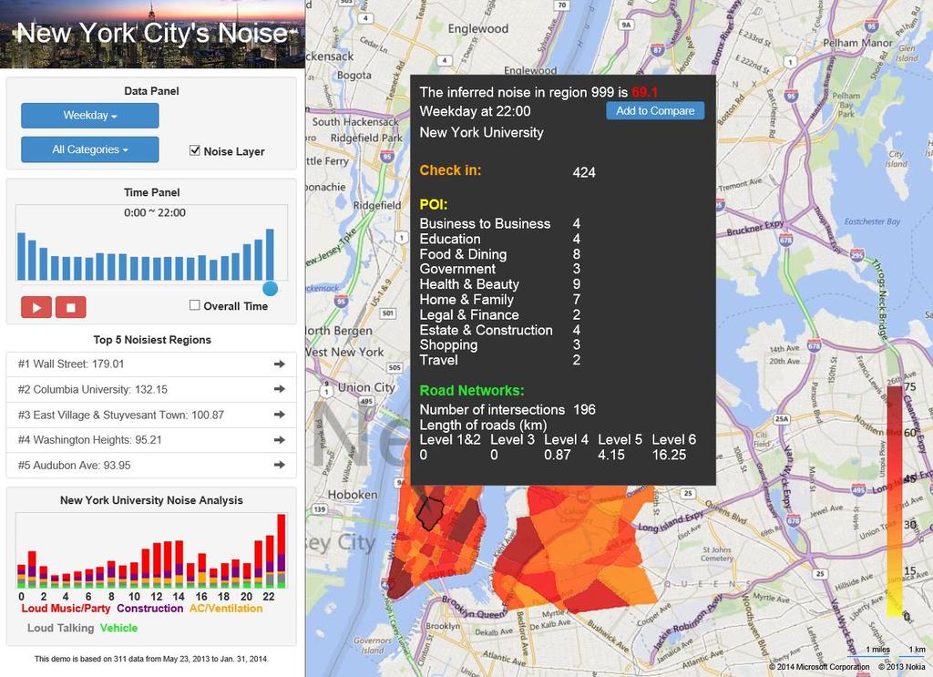
4 Goal Weekday:0-5am Weekend: 7pm-11pm Weekday: 6am-6pm Reveal the noise situation of each region in each hour A noise indicator denoting the noisy level Composition of noises in each location POIs Road Networks A) Overall noises B) Construction Check-ins 311 Data about noises C) Noise of different categories in Time Square Weekday:0-5am Weekend: 7pm-11pm Weekday: 6am-6pm Check-in all A) Overall noises B) Construction


5 Methodology Partition NYC into regions by major roads

![c,, c j,, c M ] [c 1, c,, c j,, c M ] Noise](/docs-images/89/99939256/images/6-1.jpg "Categories Noise Categories N d R R M C S d C L T d")
6 Build a 3D tensor to model the noises [r1, [r1, r r,,, ri, ri,,, rn], rn] an entry an entry A [c 1, c,, c j,, c M ] [c 1, c,, c j,, c M ] Noise Categories Noise Categories N d R R M C S d C L T d T T Sparsity


7 Data sparseness 311 in NYC 90% regions receives 1 complaint per day on weekdays 75% regions receives 1 complaint per day on weekends Figure 6. Proportion of regions with complaints smaller than a number Figure 7. The proportion of regions with complaints of a noise category 68 weekdays
8 Methodology 311 complaints about noises POIs and Road Networks User check-in Features Road intersection Categories X X = R U 311 complaint POIs Small streets Major roads A Categories Categories Z Check-ins Check-in all L S, R, C, T, U = 1 A S R R C C T T + λ 1 X RU + λ tr CT L Z C + λ 3 S + R + C + T + U + λ 4 Time slots Y Y = T R T Y = T R T Y TRT
9 [r1, r,, ri,, rn] L S, R, C, T, U = 1 A S R R C C T T + λ 1 X RU + λ tr CT L Z C + λ 3 Y TR T + λ 4 S + R + C + T + U ] N [r1, r,, ri,, rn] d R R Features Noise Categories S R X X = R U d C M M dc R AN λ 1 [c 1, c,, c j,, c M ] Noise Categories A an entry an entry [c 1, c,, c j,, c M ] C d C L ST U [r1, r,, ri,, rn d T T L Time slots A Categories M d T Y Y = T R T X RU Y = T R N A N d R R d R R an entry C S M d C C S d C T T L T L Noise Categories d TR d T [c1, c,, cj,, cm] Categories 1 i,j Categories Z c i c j Z ij = = tr C T D Z C = tr(c T L Z C) M 1 A S R R C C T T C d C [r 1, r,, r i,, r N ] A an entry N S T R T LN T T d R R λ 3 N R S L dr M C Y TRT

10 Methodology Geographical Features Road networks Number of intersections f s r 1 r f s f r f n f d f c Length of road segments in different levels f r POIs X= ri F r F p Total number of POIs f n and density of POIs f d r N Distribution over different categories f c User check-in Road intersection 311 complaint POIs Small streets Major roads
 Correlation with noises Y implies correlation")


11 Methodology Check in data in NYC Proportion Gowalla: 17,558 check-ins (4/4/009 to 10/13/013) Foursquare: 173,75 check-ins (5/5/008 to 7/3/011) Correlation with noises Y implies correlation between different time slots correlation between different regions Proportion Noise - Vehicles Check-in - Art & Entertaiment Time of Day Noise - Loud music/party Check-in - Nightlife spot Time of Day Y= t 1 t t k r 1 r i r N d 11 r d ki t L d LN Check-in: Entertainment Check-ins: Nightlife Spot Noise: Loud Music/Party


12 Methodology Correlation between different noise categories User check-in Categories % Categories % c 1. Loud Music/Party 4. c 8. Alarms 1.7 c. Construction 17. c 9. Private carting noise 0.8 c 3. Loud Talking 14.6 c 10. Manufacturing 0.3 c 4. Vehicle POIs 13.7 c 11. Lawn care equipment 0.3 c 5. AC/Ventilation 3.9 c 1. Horn Honking 0. equipment c 6.Banging/Pounding.1 c 13. Loud Television 0.1 c 7. Jack Hammering.1 c 14. Others 0.8 Road intersection 311 complaint Small streets Major roads Z= c 1 c c j c M c 1 c j c M c 11 c c jj c MM A) weekday B) weekend

13 Road in 311 co Experiment Datasets Data sets Period Scales 311 noise data 5/3/013-1/31/014 67,378; 14 categories Foursquare 4/4/009-10/13/ ,75 Gowalla 5/5/008-7/3/011 17,558 POIs 013 6,884; 15 categories Road Network ,898 nodes, 91,649 edges User ch Check-in all Small Major
14 Evaluation of Tensor Accuracy of the inferences Remove 30% non-zero entries Features X X = R U A Categories Time slots Y Y = T R T Metrics: RMSE & MAE Categories Categories Z Methods Weekdays Weekends RMSE MAE RMSE MAE AWR AWH MF Kriging TD TD+ X TD+ X + Y TD+ X + Y+ Z Yu Zheng, et al. Diagnosing New York City s Noises with Ubiquitous Data. UbiComp 014.
15 Experiments Relative ranking performance Ranked by the inferred noise indicators Ground truth: measured by a mobile phone running a client program Metric: NDCG Location with few complaints Locations with sufficient complaints Data Inferred Data 311 Data Inferred Data 311 Data Inferred Data NDCG@ NDCG@4 NDCG@6 Daytime Nighttime A) Locations B) Correlation in 6am-6pm C) Correlation in 7pm-11pm
 Locations B) Correlation in 6am-6pm C) Correlation in")
16 311 in NYC Correlation between 311 complaints and real noise levels Measured the real noise levels of 36 locations in Manhattan People s tolerances vary in time of day Location with few complaints Locations with sufficient complaints A) Locations B) Correlation in 6am-6pm C) Correlation in 7pm-11pm
17 311 vs. Inferences Results.75% of entries on weekdays are from 311 data (97.5% by inference) 1.83% of entries on weekends are from 311 data (98.17% by inference) 311 data Inference 311 data Inference 0-6am A) Vehicles (6am-6pm) B) Loud Talking (0-5am)
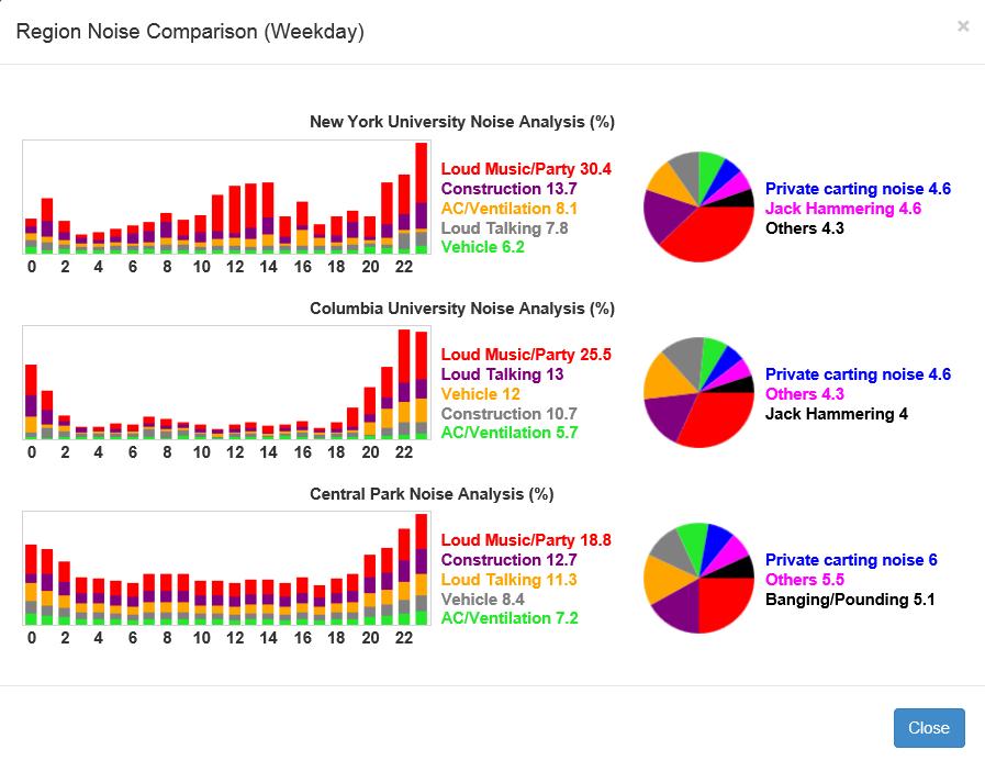
18 Results Overall noise situation in NYC Weekdays and weekends Different time of days 0-5am 6am-6pm 7pm-11pm Example Columbia University Wall Street, central park, Weekends Weekdays Time square, NYU, Columbia New York University Wall Street Central Park Time Square NYU Columbia Others Private carting noise Lawn care equipment Jack Hammering Horn Honking Alarms AC/Ventilation Manufacturing Construction Loud Television Vehicle Banging/Pounding Loud Talking Loud Music/Party Time Square Wall Street Central Park Noise Pollution Indicator

19 Weekends Weekdays Weekends Weekdays Weekends Weekdays Results Noises of particular categories Loud Music/Party Loud Talking Vehicle Construction Yu Zheng, et al. Diagnosing New York City s Noises with Ubiquitous Data. UbiComp 014.
20 Conclusion 311 data helps reveal the noise situation of the city but not accurately enough Fusing other data sources is important Spatio-temporal correlation between noises of different locations and time slots

21
22
23
Urban Computing Using Big Data to Solve Urban Challenges
 Urban Computing Using Big Data to Solve Urban Challenges Dr. Yu Zheng Lead Researcher, Microsoft Research Chair Professor at Shanghai Jiao Tong University http://research.microsoft.com/en-us/projects/urbancomputing/default.aspx
UAPD: Predicting Urban Anomalies from Spatial-Temporal Data
 UAPD: Predicting Urban Anomalies from Spatial-Temporal Data Xian Wu, Yuxiao Dong, Chao Huang, Jian Xu, Dong Wang and Nitesh V. Chawla* Department of Computer Science and Engineering University of Notre
Urban Computing Using Big Data to Solve Urban Challenges
 Urban Computing Using Big Data to Solve Urban Challenges Dr. Yu Zheng Lead Researcher, Microsoft Research Asia Chair Professor at Shanghai Jiaotong University http://research.microsoft.com/en-us/projects/urbancomputing/default.aspx
Modeling Temporal-Spatial Correlations for Crime Prediction
 Modeling Temporal-Spatial Correlations for Crime Prediction Xiangyu Zhao and Jiliang Tang Michigan State University Background Urban Security and Safety Eg. New York City Weekly Crime Report (NYPD) 1888
Encapsulating Urban Traffic Rhythms into Road Networks
 Encapsulating Urban Traffic Rhythms into Road Networks Junjie Wang +, Dong Wei +, Kun He, Hang Gong, Pu Wang * School of Traffic and Transportation Engineering, Central South University, Changsha, Hunan,
Exploring the Patterns of Human Mobility Using Heterogeneous Traffic Trajectory Data
 Exploring the Patterns of Human Mobility Using Heterogeneous Traffic Trajectory Data Jinzhong Wang April 13, 2016 The UBD Group Mobile and Social Computing Laboratory School of Software, Dalian University
Time-aware Point-of-interest Recommendation
 Time-aware Point-of-interest Recommendation Quan Yuan, Gao Cong, Zongyang Ma, Aixin Sun, and Nadia Magnenat-Thalmann School of Computer Engineering Nanyang Technological University Presented by ShenglinZHAO
Exploring the Impact of Ambient Population Measures on Crime Hotspots
 Exploring the Impact of Ambient Population Measures on Crime Hotspots Nick Malleson School of Geography, University of Leeds http://nickmalleson.co.uk/ N.S.Malleson@leeds.ac.uk Martin Andresen Institute
Point-of-Interest Recommendations: Learning Potential Check-ins from Friends
 Point-of-Interest Recommendations: Learning Potential Check-ins from Friends Huayu Li, Yong Ge +, Richang Hong, Hengshu Zhu University of North Carolina at Charlotte + University of Arizona Hefei University
Where to Find My Next Passenger?
 Where to Find My Next Passenger? Jing Yuan 1 Yu Zheng 2 Liuhang Zhang 1 Guangzhong Sun 1 1 University of Science and Technology of China 2 Microsoft Research Asia September 19, 2011 Jing Yuan et al. (USTC,MSRA)
Inferring Friendship from Check-in Data of Location-Based Social Networks
 Inferring Friendship from Check-in Data of Location-Based Social Networks Ran Cheng, Jun Pang, Yang Zhang Interdisciplinary Centre for Security, Reliability and Trust, University of Luxembourg, Luxembourg
By Abdulraheem M.Baabbad. Supervisor: Dr.Bager Al-Ramadan
 By Abdulraheem M.Baabbad Supervisor: Dr.Bager Al-Ramadan OUTLINE Health GIS Health GIS Application Emergency Vehicles Allocation: A case study Health GIS Innovative structureto access,integrate,visualize
Social and Technological Network Analysis: Spatial Networks, Mobility and Applications
 Social and Technological Network Analysis: Spatial Networks, Mobility and Applications Anastasios Noulas Computer Laboratory, University of Cambridge February 2015 Today s Outline 1. Introduction to spatial
Improving the travel time prediction by using the real-time floating car data
 Improving the travel time prediction by using the real-time floating car data Krzysztof Dembczyński Przemys law Gawe l Andrzej Jaszkiewicz Wojciech Kot lowski Adam Szarecki Institute of Computing Science,
Urban Link Travel Time Estimation Using Large-scale Taxi Data with Partial Information
 Urban Link Travel Time Estimation Using Large-scale Taxi Data with Partial Information * Satish V. Ukkusuri * * Civil Engineering, Purdue University 24/04/2014 Outline Introduction Study Region Link Travel
DM-Group Meeting. Subhodip Biswas 10/16/2014
 DM-Group Meeting Subhodip Biswas 10/16/2014 Papers to be discussed 1. Crowdsourcing Land Use Maps via Twitter Vanessa Frias-Martinez and Enrique Frias-Martinez in KDD 2014 2. Tracking Climate Change Opinions
Incorporating Spatio-Temporal Smoothness for Air Quality Inference
 2017 IEEE International Conference on Data Mining Incorporating Spatio-Temporal Smoothness for Air Quality Inference Xiangyu Zhao 2, Tong Xu 1, Yanjie Fu 3, Enhong Chen 1, Hao Guo 1 1 Anhui Province Key
VISUAL EXPLORATION OF SPATIAL-TEMPORAL TRAFFIC CONGESTION PATTERNS USING FLOATING CAR DATA. Candra Kartika 2015
 VISUAL EXPLORATION OF SPATIAL-TEMPORAL TRAFFIC CONGESTION PATTERNS USING FLOATING CAR DATA Candra Kartika 2015 OVERVIEW Motivation Background and State of The Art Test data Visualization methods Result
K-Nearest Neighbor Temporal Aggregate Queries
 Experiments and Conclusion K-Nearest Neighbor Temporal Aggregate Queries Yu Sun Jianzhong Qi Yu Zheng Rui Zhang Department of Computing and Information Systems University of Melbourne Microsoft Research,
Urban Computing: Concepts, Methodologies, and Applications
 Urban Computing: Concepts, Methodologies, and Applications YU ZHENG, Microsoft Research LICIA CAPRA, University College London OURI WOLFSON, University of Illinois at Chicago HAI YANG, Hong Kong University
Friendship and Mobility: User Movement In Location-Based Social Networks. Eunjoon Cho* Seth A. Myers* Jure Leskovec
 Friendship and Mobility: User Movement In Location-Based Social Networks Eunjoon Cho* Seth A. Myers* Jure Leskovec Outline Introduction Related Work Data Observations from Data Model of Human Mobility
Accepted Manuscript. DynamiCITY : Revealing city dynamics from citizens social media broadcasts
 Accepted Manuscript DynamiCITY : Revealing city dynamics from citizens social media broadcasts Vasiliki Gkatziaki, Maria Giatsoglou, Despoina Chatzakou, Athena Vakali PII: S0306-4379(17)30065-0 DOI: 10.1016/j.is.2017.07.007
U-Air: When Urban Air Quality Inference Meets Big Data
 U-Air: When Urban Air Quality Inference Meets Big Data Yu Zheng, Furui Liu, Hsun-Ping Hsieh Microsoft Research Asia, Beijing China {yuzheng, v-ful, v-hshsie}@microsoft.com ABSTRACT Information about urban
A Heterogeneous Model Integration for Multi-source Urban Infrastructure Data
 A Heterogeneous Model Integration for Multi-source Urban Infrastructure Data DESHENG ZHANG, Rutgers University, USA JUANJUAN ZHAO, Shenzhen Institutes of Advanced Technology, China FAN ZHANG, Shenzhen
Discovering and Characterizing Mobility Patterns in Urban Spaces: A Study of Manhattan Taxi Data
 Discovering and Characterizing Mobility Patterns in Urban Spaces: A Study of Manhattan Taxi Data Lisette Espín-Noboa Lisette.Espin@gesis.org Philipp Singer Philipp.Singer@gesis.org Florian Lemmerich Florian.Lemmerich@gesis.org
Aggregated Temporal Tensor Factorization Model for Point-of-interest Recommendation
 Aggregated Temporal Tensor Factorization Model for Point-of-interest Recommendation Shenglin Zhao 1,2B, Michael R. Lyu 1,2, and Irwin King 1,2 1 Shenzhen Key Laboratory of Rich Media Big Data Analytics
Temporal Multi-View Inconsistency Detection for Network Traffic Analysis
 WWW 15 Florence, Italy Temporal Multi-View Inconsistency Detection for Network Traffic Analysis Houping Xiao 1, Jing Gao 1, Deepak Turaga 2, Long Vu 2, and Alain Biem 2 1 Department of Computer Science
GIScience & Mobility. Prof. Dr. Martin Raubal. Institute of Cartography and Geoinformation SAGEO 2013 Brest, France
 GIScience & Mobility Prof. Dr. Martin Raubal Institute of Cartography and Geoinformation mraubal@ethz.ch SAGEO 2013 Brest, France 25.09.2013 1 www.woodsbagot.com 25.09.2013 2 GIScience & Mobility Modeling
Improving forecasting under missing data on sparse spatial networks
 Improving forecasting under missing data on sparse spatial networks J. Haworth 1, T. Cheng 1, E. J. Manley 1 1 SpaceTimeLab, Department of Civil, Environmental and Geomatic Engineering, University College
Predicting highly-resolved traffic noise
 Predicting highly-resolved traffic noise (using data available as a by-product of Urban Traffic Management and Control systems) Dr Shadman Marouf, Professor Margaret C. Bell, CBE Future Mobility Group,
Noise Maps, Report & Statistics, Dublin City Council Noise Mapping Project Roads and Traffic Department
 Noise Maps, Report & Statistics, Dublin City Council Noise Mapping Project Roads and Traffic Department Produced by Traffic Noise & Air Quality Unit November 2007 Contact: brian.mcmanus@dublincity.ie Ph;
Exploiting Geographic Dependencies for Real Estate Appraisal
 Exploiting Geographic Dependencies for Real Estate Appraisal Yanjie Fu Joint work with Hui Xiong, Yu Zheng, Yong Ge, Zhihua Zhou, Zijun Yao Rutgers, the State University of New Jersey Microsoft Research
T-Finder: A Recommender System for Finding Passengers and Vacant Taxis
 1 T-Finder: A Recommender System for Finding Passengers and Vacant Taxis Nicholas Jing Yuan, Yu Zheng, Liuhang Zhang, Xing Xie Abstract This paper presents a recommender system for both taxi drivers and
An Implementation of Mobile Sensing for Large-Scale Urban Monitoring
 An Implementation of Mobile Sensing for Large-Scale Urban Monitoring Teerayut Horanont 1, Ryosuke Shibasaki 1,2 1 Department of Civil Engineering, University of Tokyo, Meguro, Tokyo 153-8505, JAPAN Email:
Spatial-Temporal Analytics with Students Data to recommend optimum regions to stay
 Spatial-Temporal Analytics with Students Data to recommend optimum regions to stay By ARUN KUMAR BALASUBRAMANIAN (A0163264H) DEVI VIJAYAKUMAR (A0163403R) RAGHU ADITYA (A0163260N) SHARVINA PAWASKAR (A0163302W)
City of Hermosa Beach Beach Access and Parking Study. Submitted by. 600 Wilshire Blvd., Suite 1050 Los Angeles, CA
 City of Hermosa Beach Beach Access and Parking Study Submitted by 600 Wilshire Blvd., Suite 1050 Los Angeles, CA 90017 213.261.3050 January 2015 TABLE OF CONTENTS Introduction to the Beach Access and Parking
Roadway Traffic Noise Assessment. 407 Nelson Street Ottawa, Ontario
 407 Nelson Street Ottawa, Ontario REPORT: GWE17-042 Traffic Noise Prepared For: Tony Kazarian AK Global Management Inc. 680 Eagleson Road Ottawa, Ontario K2M 2G9 Canada Prepared By: Omar Daher, B.Eng.,
Learning to Recommend Point-of-Interest with the Weighted Bayesian Personalized Ranking Method in LBSNs
 information Article Learning to Recommend Point-of-Interest with the Weighted Bayesian Personalized Ranking Method in LBSNs Lei Guo 1, *, Haoran Jiang 2, Xinhua Wang 3 and Fangai Liu 3 1 School of Management
Density and Walkable Communities
 Density and Walkable Communities Reid Ewing Professor & Chair City and Metropolitan Planning University of Utah ewing@arch.utah.edu Department of City & Metropolitan Planning, University of Utah MRC Research
UAPD: Predicting Urban Anomalies from Spatial-Temporal Data
 UAPD: Predicting Urban Anomalies from Spatial-Temporal Data Xian Wu 1, Yuxiao Dong 1,2, Chao Huang 1, Jian Xu 1, Dong Wang 1, Nitesh V. Chawla 1 1 Department of Computer Science and Engineering, and icensa
Data fusion techniques for real-time mapping of urban air quality
 ESA eo open science 2.0 12-14 October 2015, Frascati, Italy Making sense of crowdsourced observations: Data fusion techniques for real-time mapping of urban air quality Philipp Schneider 1 Nuria Castell
Risk Assessment of Stampede Accidents in Rail Transit Stations based on Analytic Hierarchy Process
 Risk Assessment of Stampede Accidents in Rail Transit Stations based on Analytic Hierarchy Process Xuqian Qin Zhongnan University of Economics and Law ollege of Information and Safety Engineering, Hubei
Spatial Data, Spatial Analysis and Spatial Data Science
 Spatial Data, Spatial Analysis and Spatial Data Science Luc Anselin http://spatial.uchicago.edu 1 spatial thinking in the social sciences spatial analysis spatial data science spatial data types and research
Sparsity Models. Tong Zhang. Rutgers University. T. Zhang (Rutgers) Sparsity Models 1 / 28
 Sparsity Models 1 / 28") Sparsity Models Tong Zhang Rutgers University T. Zhang (Rutgers) Sparsity Models 1 / 28 Topics Standard sparse regression model algorithms: convex relaxation and greedy algorithm sparse recovery analysis:
Sparsity Models Tong Zhang Rutgers University T. Zhang (Rutgers) Sparsity Models 1 / 28 Topics Standard sparse regression model algorithms: convex relaxation and greedy algorithm sparse recovery analysis:
Data Mining II Mobility Data Mining
 Data Mining II Mobility Data Mining F. Giannotti& M. Nanni KDD Lab ISTI CNR Pisa, Italy Outline Mobility Data Mining Introduction MDM methods MDM methods at work. Understanding Human Mobility Clustering
arxiv: v1 [cs.si] 23 Jan 2017
![arxiv: v1 [cs.si] 23 Jan 2017](/thumbs/75/72288618.jpg "arxiv: v1 [cs.si] 23 Jan 2017") Mining Shopping Patterns for Divergent Urban Regions by Incorporating Mobility Data Tianran Hu 1, Ruihua Song 2, Yingzi Wang 3, Xing Xie 4, Jiebo Luo 5 University of Rochester Microsoft Research University
Mining Shopping Patterns for Divergent Urban Regions by Incorporating Mobility Data Tianran Hu 1, Ruihua Song 2, Yingzi Wang 3, Xing Xie 4, Jiebo Luo 5 University of Rochester Microsoft Research University
Extracting User Spatio-Temporal Profiles from Location Based Social Networks
 Extracting User Spatio-Temporal Profiles from Location Based Social Networks Javier Béjar Departament de Ciències de la Computació Universitat Politècnica de Catalunya bejar@cs.upc.edu Abstract Location
Roadway Traffic Noise Feasibility Assessment. 315 Chapel Street. Ottawa, Ontario
 Roadway Traffic Noise Feasibility Assessment 315 Chapel Street Ottawa, Ontario REPORT: GWE17-002 - Traffic Noise Prepared For: Leanne Moussa Allsaints 10 Blackburn Avenue K1N 6P8 Ottawa, Ontario Prepared
AREP GAW. AQ Forecasting
 AQ Forecasting What Are We Forecasting Averaging Time (3 of 3) PM10 Daily Maximum Values, 2001 Santiago, Chile (MACAM stations) 300 Level 2 Pre-Emergency Level 1 Alert 200 Air Quality Standard 150 100
Collaborative Location Recommendation by Integrating Multi-dimensional Contextual Information
 1 Collaborative Location Recommendation by Integrating Multi-dimensional Contextual Information LINA YAO, University of New South Wales QUAN Z. SHENG, Macquarie University XIANZHI WANG, Singapore Management
An Interactive Visualization System to Analyze and Predict Urban Construction Dynamics
 An Interactive Visualization System to Analyze and Predict Urban Construction Dynamics Tzu-Chi Yen Sensoro Technology Co., Ltd., Beijing, China junipertcy@gmail.com Hsun-Ping Hsieh National Taiwan University
Geographical Bias on Social Media and Geo-Local Contents System with Mobile Devices
 212 45th Hawaii International Conference on System Sciences Geographical Bias on Social Media and Geo-Local Contents System with Mobile Devices Kazunari Ishida Hiroshima Institute of Technology k.ishida.p7@it-hiroshima.ac.jp
Visualisation of Spatial Data
 Visualisation of Spatial Data VU Visual Data Science Johanna Schmidt WS 2018/19 2 Visual Data Science Introduction to Visualisation Basics of Information Visualisation Charts and Techniques Introduction
GIS ANALYSIS METHODOLOGY
 GIS ANALYSIS METHODOLOGY No longer the exclusive domain of cartographers, computer-assisted drawing technicians, mainframes, and workstations, geographic information system (GIS) mapping has migrated to
Activity Identification from GPS Trajectories Using Spatial Temporal POIs Attractiveness
 Activity Identification from GPS Trajectories Using Spatial Temporal POIs Attractiveness Lian Huang, Qingquan Li, Yang Yue State Key Laboratory of Information Engineering in Survey, Mapping and Remote
Oak Ridge Urban Dynamics Institute
 Oak Ridge Urban Dynamics Institute Presented to ORNL NEED Workshop Budhendra Bhaduri, Director Corporate Research Fellow July 30, 2014 Oak Ridge, TN Our societal challenges and solutions are often local
Collaborative Target Detection in Wireless Sensor Networks with Reactive Mobility
 1 / 24 Collaborative Target Detection in Wireless Sensor Networks with Reactive Mobility Rui Tan 1 Guoliang Xing 1 Jianping Wang 1 Hing Cheung So 2 1 Department of Computer Science City University of Hong
3D Urban Information Models in making a smart city the i-scope project case study
 UDC: 007:528.9]:004; 007:912]:004; 004.92 DOI: 10.14438/gn.2014.17 Typology: 1.04 Professional Article 3D Urban Information Models in making a smart city the i-scope project case study Dragutin PROTIĆ
Differentially Private Real-time Data Release over Infinite Trajectory Streams
 Differentially Private Real-time Data Release over Infinite Trajectory Streams Kyoto University, Japan Department of Social Informatics Yang Cao, Masatoshi Yoshikawa 1 Outline Motivation: opportunity &
Exploring the Use of Urban Greenspace through Cellular Network Activity
 Exploring the Use of Urban Greenspace through Cellular Network Activity Ramón Cáceres 1, James Rowland 1, Christopher Small 2, and Simon Urbanek 1 1 AT&T Labs Research, Florham Park, NJ, USA {ramon,jrr,urbanek}@research.att.com
Measurement of human activity using velocity GPS data obtained from mobile phones
 Measurement of human activity using velocity GPS data obtained from mobile phones Yasuko Kawahata 1 Takayuki Mizuno 2 and Akira Ishii 3 1 Graduate School of Information Science and Technology, The University
How ACS Data Can Make Smart Cities Even Smarter: A method for combining bike sensor data with ACS demographic data Peter Viechnicki, Deloitte Center
 How ACS Data Can Make Smart Cities Even Smarter: A method for combining bike sensor data with ACS demographic data Peter Viechnicki, Deloitte Center for Government Insights, 12 May 2017 pviechnicki@deloitte.com,
Spatiotemporal Analysis of Urban Traffic Accidents: A Case Study of Tehran City, Iran
 Spatiotemporal Analysis of Urban Traffic Accidents: A Case Study of Tehran City, Iran January 2018 Niloofar HAJI MIRZA AGHASI Spatiotemporal Analysis of Urban Traffic Accidents: A Case Study of Tehran
An environmental modelling and information service for health analytics
 An environmental modelling and information service for health analytics Oliver Schmitz1, Derek Karssenberg1, Kor de Jong1, Harm de Raaff2 1 Department of Physical Geography, Faculty of Geosciences, Utrecht
City and SUMP of Ravenna
 City and SUMP of Ravenna Nicola Scanferla Head of Mobility Planning Unit, Municipality of Ravenna nscanferla@comune.ra.it place your logo here 19 April, 2017 1st Steering Committee Meeting, Nicosia, Cyprus
Metropolitan Wi-Fi Research Network at the Los Angeles State Historic Park
 Metropolitan Wi-Fi Research Network at the Los Angeles State Historic Park Vidyut Samanta vids@remap.ucla.edu Chase Laurelle Alexandria Knowles chase@remap.ucla.edu Jeff Burke jburke@remap.ucla.edu Fabian
Local Area Emergency (LAE)
") Local Area Emergency (LAE) An emergency message that defines an event that, by itself, does not pose a significant threat to public safety and/or property. However, the event could escalate, contribute
Local Area Emergency (LAE) An emergency message that defines an event that, by itself, does not pose a significant threat to public safety and/or property. However, the event could escalate, contribute
Trip and Parking Generation Study of Orem Fitness Center-Abstract
 Trip and Parking Generation Study of Orem Fitness Center-Abstract The Brigham Young University Institute of Transportation Engineers student chapter (BYU ITE) completed a trip and parking generation study
Blog Community Discovery and Evolution
 Blog Community Discovery and Evolution Mutual Awareness, Interactions and Community Stories Yu-Ru Lin, Hari Sundaram, Yun Chi, Junichi Tatemura and Belle Tseng What do people feel about Hurricane Katrina?
TOWARDS ESTIMATING THE PRESENCE OF VISITORS FROM THE AGGREGATE MOBILE PHONE NETWORK ACTIVITY THEY GENERATE
 TOWARDS ESTIMATING THE PRESENCE OF VISITORS FROM THE AGGREGATE MOBILE PHONE NETWORK ACTIVITY THEY GENERATE Fabien GIRARDIN SENSEable City Laboratory Massachusetts Institute of Technology 77 Massachusetts
City form and its macroscopic fundamental diagram
 Research Collection Presentation City form and its macroscopic fundamental diagram Author(s): Axhausen, Kay W. Publication Date: 2018-06 Permanent Link: https://doi.org/10.3929/ethz-b-000267750 Rights
OPTIMIZATION OF TRAFFIC SAFETY ON RURAL ROADS BY TRAFFIC DATA BASED STRATEGIES
 OPTIMIZATION OF TRAFFIC SAFETY ON RURAL ROADS BY TRAFFIC DATA BASED STRATEGIES STEFFEN AXER, BERNHARD FRIEDRICH INSTITUTE OF TRANSPORTATION AND URBAN ENGINEERING TECHNISCHE UNIVERSITÄT BRAUNSCHWEIG This
CITY OF NEW LONDON WINTER ROAD & SIDEWALK MAINTENANCE POLICY
 CITY OF NEW LONDON WINTER ROAD & SIDEWALK MAINTENANCE POLICY GENERAL The purpose of this policy is to set up acceptable procedures and policies for the winter maintenance of public areas in the City of
PATREC PERSPECTIVES Sensing Technology Innovations for Tracking Congestion
 PATREC PERSPECTIVES Sensing Technology Innovations for Tracking Congestion Drivers have increasingly been using inexpensive mapping applications imbedded into mobile devices (like Google Maps, MapFactor,
SNOW REMOVAL GUIDE. City Of Orange Township. Public Works Snow Removal Hotline: (973) My Orange Hotline: (973)
 My Orange Hotline: (973)") Mayor Dwayne D. Warren, Esq. And The Orange Municipal Council MOVING ORANGE FORWARD City Of Orange Township SNOW REMOVAL GUIDE Public Works Snow Removal Hotline: (973) 266-4030 My Orange Hotline: (973)
Mayor Dwayne D. Warren, Esq. And The Orange Municipal Council MOVING ORANGE FORWARD City Of Orange Township SNOW REMOVAL GUIDE Public Works Snow Removal Hotline: (973) 266-4030 My Orange Hotline: (973)
Empirical Invistigation of Day-To-Day Variability In Driver Travel Behaviour
 Empirical Invistigation of Day-To-Day Variability In Driver Travel Behaviour The See you next Wednesday Effect Department of Mathematics, University of York, YO10 5DD Universities Transport Studies Group,
Mining Frequent Spatio-Temporal Patterns from Location Based Social Networks
 Mining Frequent Spatio-Temporal Patterns from Location Based Social Networks Javier Béjar Departament de Ciències de la Computació Universitat Politècnica de Catalunya (BarcelonaTech) bejar@lsi.upc.edu
DYNAMIC TRIP ATTRACTION ESTIMATION WITH LOCATION BASED SOCIAL NETWORK DATA BALANCING BETWEEN TIME OF DAY VARIATIONS AND ZONAL DIFFERENCES
 DYNAMIC TRIP ATTRACTION ESTIMATION WITH LOCATION BASED SOCIAL NETWORK DATA BALANCING BETWEEN TIME OF DAY VARIATIONS AND ZONAL DIFFERENCES Nicholas W. Hu a, Peter J. Jin b, * a Department of Civil and Environmental
Spatial Data Science. Soumya K Ghosh
 Workshop on Data Science and Machine Learning (DSML 17) ISI Kolkata, March 28-31, 2017 Spatial Data Science Soumya K Ghosh Professor Department of Computer Science and Engineering Indian Institute of Technology,
Classification in Mobility Data Mining
 Classification in Mobility Data Mining Activity Recognition Semantic Enrichment Recognition through Points-of-Interest Given a dataset of GPS tracks of private vehicles, we annotate trajectories with the
Appendix E FTA NOISE MODELING WORKSHEETS AND DETAILED METHODOLOGY
 Appendix E FTA NOISE MODELING WORKSHEETS AND DETAILED METHODOLOGY APPENDIX E General Noise Assessment The FTA General Noise Assessment procedure was used for calculating noise from transit sources associated
Predicting Long-term Exposures for Health Effect Studies
 Predicting Long-term Exposures for Health Effect Studies Lianne Sheppard Adam A. Szpiro, Johan Lindström, Paul D. Sampson and the MESA Air team University of Washington CMAS Special Session, October 13,
Location Determination Technologies for Sensor Networks
 Location Determination Technologies for Sensor Networks Moustafa Youssef University of Maryland at College Park UMBC Talk March, 2007 Motivation Location is important: Determining the location of an event
SHORT NIGHTTIME WATER SHUTDOWN TO OCCUR IN EARLY HOURS OF MAY 29
 Thank you for your interest in the Center City Connector Streetcar. In this weekly update, you ll find information about ongoing construction for the 1st phase of utility work in Pioneer Square. UPDATES
Traffic accidents and the road network in SAS/GIS
 Traffic accidents and the road network in SAS/GIS Frank Poppe SWOV Institute for Road Safety Research, the Netherlands Introduction The first figure shows a screen snapshot of SAS/GIS with part of the
Modeling Crowd Flows Network to Infer Origins and Destinations of Crowds from Cellular Data
 Modeling Crowd Flows Network to Infer Origins and Destinations of Crowds from Cellular Data Ai-Jou Chou ajchou@cs.nctu.edu.tw Gunarto Sindoro Njoo gunarto.cs01g@g2.nctu.edu.tw Wen-Chih Peng wcpeng@cs.nctu.edu.tw
Social and Technological Network Analysis. Lecture 11: Spa;al and Social Network Analysis. Dr. Cecilia Mascolo
 Social and Technological Network Analysis Lecture 11: Spa;al and Social Network Analysis Dr. Cecilia Mascolo In This Lecture In this lecture we will study spa;al networks and geo- social networks through
Validating general human mobility patterns on massive GPS data
 Validating general human mobility patterns on massive GPS data Luca Pappalardo, Salvatore Rinzivillo, Dino Pedreschi, and Fosca Giannotti KDDLab, Institute of Information Science and Technologies (ISTI),
Location Regularization-Based POI Recommendation in Location-Based Social Networks
 information Article Location Regularization-Based POI Recommendation in Location-Based Social Networks Lei Guo 1,2, * ID, Haoran Jiang 3 and Xinhua Wang 4 1 Postdoctoral Research Station of Management
Research Article Urban Mobility Dynamics Based on Flexible Discrete Region Partition
 International Journal of Distributed Sensor Networks, Article ID 782649, 1 pages http://dx.doi.org/1.1155/214/782649 Research Article Urban Mobility Dynamics Based on Flexible Discrete Region Partition
Analysis of Spatial and Temporal Distribution of Single and Multiple Vehicle Crash in Western Australia: A Comparison Study
 19th International Congress on Modelling and Simulation, Perth, Australia, 12 16 December 2011 http://mssanz.org.au/modsim2011 Analysis of Spatial and Temporal Distribution of Single and Multiple Vehicle
Exploring Human Mobility with Multi-Source Data at Extremely Large Metropolitan Scales. ACM MobiCom 2014, Maui, HI
 Exploring Human Mobility with Multi-Source Data at Extremely Large Metropolitan Scales Desheng Zhang & Tian He University of Minnesota, USA Jun Huang, Ye Li, Fan Zhang, Chengzhong Xu Shenzhen Institute
City-wide examining transport network accessibility using taxi GPS data
 City-wide examining transport network accessibility using taxi GPS data Jianxun Cui 1, Feng Liu 2,3, Davy Janssens 2, An Shi 1 and Geert Wets 2 1 School of Transportation Science and Engineering, Harbin
Texas A&M University
 Texas A&M University CVEN 658 Civil Engineering Applications of GIS Hotspot Analysis of Highway Accident Spatial Pattern Based on Network Spatial Weights Instructor: Dr. Francisco Olivera Author: Zachry
UN-GGIM: User case studies ISRAEL
 UNGGIM: User case studies ISRAEL ISRAEL GIS for 2008 Integrated Population Census GIS was used as a main infrastructure for the 2008 Israeli integrated census of population The Integrated Census is based
COUNCIL POLICY MANUAL
 COUNCIL POLICY MANUAL SECTION: PUBLIC WORKS SUBJECT: SNOW & ICE CONTROL POLICY 2012/2013 GOAL: Pages: 1 of 10 Approval Date: Dec. 3, 2012 Res. # 1001/2012 To annually identify the winter maintenance costs
Let's Make Our Cities Breathable BECAUSE CLEAN AIR BELONGS TO EVERYONE.
 Let's Make Our Cities Breathable BECAUSE CLEAN AIR BELONGS TO EVERYONE. Clean Air is a Human Right that Everyone Should be Entitled to Making cities more breathable starts by measuring, analyzing and understanding
Leaving the Ivory Tower of a System Theory: From Geosimulation of Parking Search to Urban Parking Policy-Making
 Leaving the Ivory Tower of a System Theory: From Geosimulation of Parking Search to Urban Parking Policy-Making Itzhak Benenson 1, Nadav Levy 1, Karel Martens 2 1 Department of Geography and Human Environment,
FCCF: Forecasting Citywide Crowd Flows Based on Big Data
 FF: Forecasting itywide rowd Flows ased on ig Data Minh X. Hoang University of alifornia, Santa arbara mhoangcs.ucsb.edu Yu Zheng Microsoft Research eijing, hina yuzhengmicrosoft.com mbuj K. Singh University
Leveraging Data Relationships to Resolve Conflicts from Disparate Data Sources. Romila Pradhan, Walid G. Aref, Sunil Prabhakar
 Leveraging Data Relationships to Resolve Conflicts from Disparate Data Sources Romila Pradhan, Walid G. Aref, Sunil Prabhakar Fusing data from multiple sources Data Item S 1 S 2 S 3 S 4 S 5 Basera 745