Map 1: Seismic Hazard Map of South Asia Region. Z = Seismic Zoning Factor for Design of Buildings in Nepal Map 2: Seismic zoning of Nepal
|
|
|
- Bartholomew Emery Stevens
- 5 years ago
- Views:
Transcription
1
 during October 2011 September 2014.")
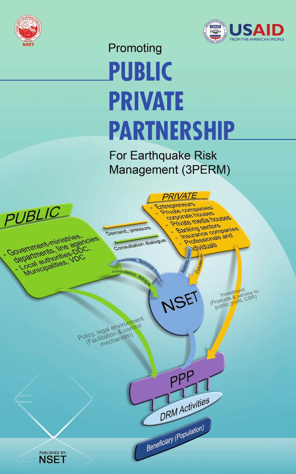
2 National Society for Earthquake Technology-Nepal (NSET) is implementing the program Promoting Public Private Partnership for Earthquake Risk Management (3PERM) with the funding support from United States Agency for International Development, Office of U.S. Foreign Disaster Assistance (USAID/OFDA) during October 2011 September This program envisions on tapping the vast potentials of private sector for contribution to Earthquake Risk Reduction in Kathmandu Valley and Nepal. The participation of the private sector is essential, and should be a matter of fact perpetually in disaster risk reduction processes. Therefore, it is necessary to raise awareness of the private sector, convince the businesses that earthquake risk management is much more than charity, and demonstrate the economic, social and corporate feasibility of PPP in disaster risk reduction, and pursuade that it is a sound investment to be done. 3PERM also emphasizes on the added benefits of this program to other sectors such as tourism, cultural heritage preservation, contribution to social assets generation and others. This 3-year program has been moduled with the view to a) Raise awareness of all stakeholders, especially the private sector and other stakeholders that closely relate with potential earthquake risk reduction activities to be led by the private sector, b) Enhance the level of commmitments and potential energy and leadership of private sector to consider Earthquake Risk Management as one of the priority areas for mainstreaming into the development processes, and c) Implement a detailed study of the model PPP in urban regeneration to be piloted in a demonstration neighborhood of the core area of Kathmandu. Background Nepal faces a variety of natural hazards. The frequency and intensities of natural hazards are very high. Earthquake is one of the most significant natural hazards the entire country faces. The entire country falls in a high earthquake intensity belt (Map 1). The seismic zoning map of Nepal divides the country into three zones the middle part of the country is slightly higher than the northern and the southern parts (Map 2). Map 1: Seismic Hazard Map of South Asia Region (Source: Global Seismic Hazard Map) Z = Seismic Zoning Factor for Design of Buildings in Nepal Map 2: Seismic zoning of Nepal (Source: National Building Code of Nepal, 1994) The country has a long history of destructive earthquakes. About ten episodes of earthquake shaking greater than or equal to intensities MMI IX have been reported in Kathmandu in the past 750 years! Earthquake of the year 1934 (1990B.S.) is the most devastating one in the Nepali history that caused 8519 human deaths, destroyed 20 percent and damaged 40 percent of the valley s building stock. The most recent earthquake that badly hit Nepal was the
3 moderate size earthquake (Magnitude 6.6) of 1988 affecting mostly the eastern part of Nepal. 721 people lost their lives in this earthquake. The very recent tremor of 18 September 2011 has deeply alarmed to pay more organized efforts on promoting Earthquake Safety of Nepal. Public Private Partnership (PPP) for Disaster Risk Management (DRM) is a new concept in Nepal. However this approach promises to be one of the most effective approaches as it helps creating win-win situation by: Sharing by the public and private sectors the perceived roles in disaster risk management, Unleashing the local potentials by contributing towards fulfilling the roles expected by the society, not only as a responsibility but as business as usual, Contributing to reduce disaster risks, protection of the environment, raising voice for a better governance including making cities safer by better enforcement of the building codes; enhancing both the government's and companies ability to recover from earthquake losses. Program Description The overall Goal of the program is: Improved earthquake disaster resilience of Nepal The Objective of the program is - Increase disaster awareness and promote public private partnership (PPP) for earthquake risk management in Nepal. PROGRAM STRATEGY NSET adopts following key approaches: a) Awareness-raising and capacity building will be the inherent component of all program activities. All activities are geared towards increasing disaster awareness of corporate sector, community, and the government. Similarly, enhancing capacity of people and institutions will be in focus in all program activities. b) Use of existing local capacity/ local community interaction: NSET s activities, including those proposed under this program, are to be implemented by using local technical people with active participation of the local communities and local leaders. These actions are the felt-needs ones, and the involvement of local stakeholder s representative drives the programs to a higher level of acceptability and ownership by local people, institutions, and the local government. c) Learning from international standards and practices: NSET is already practicing and will continue to subscribe to the principles and standards promulgated by such forum as INSARAG, and SPHERE. The experiences of urban regeneration programs, for example those implemented in Boston, Baltimore and New Orleans in the US and in many Mediterranean cities and also the experiences of European cities such as those of Barcelona, Marseilles, and Genoa will be translated to local context and conditions. d) Collaboration/coordination: NSET believes in sharing information and experiences. NSET has posted and will continue posting all of its publications, methodologies, information and experiences in its web site e) Institutionalization: NSET will emphasize on institutionalization of the methodology, processes and successes for the long-term sustainability of the DRR. The following are the main activities, strategies and approaches for their implementation. Activity 1: Conduct Massive Awareness Campaign on ERM A massive awareness campaign is to be conducted for raising general awareness on DRM and also on the possibilities of public private partnership for ERM. The campaign itself will be conducted on a public private partnership approach. Collaboration with several private companies will be explored and encouraged for the campaign.
4 The following sub-activities are proposed under the campaign: a) Radio programs: Weekly radio program (through 20FM Radio Stations from all over the country) and Radio PSAs. b) Television programs: Weekly TV programs, TV PSAs and Telefilms c) Campaign through print media: PSAs, Articles/Columns, Reports d) Publications: Hand Books, Guideline on earthquake safety construction methods, Posters & Fliers e) Internet campaign/e-bulletin (Monthly) f) Display boards (hording boards or electronic boards) with earthquake safety messages in at least 3 locations in all of the 58 municipalities and 75 district headquarters of Nepal g) Door-to-door campaign (mobile clinics) to building construction sites. h) Street drama and other demonstrations (at least in 3 places in each development region) i) Production and distribution of Short Thematic Video films (5min, 10min & 15 min duration) j) Development and Distribution of CDs/DVDs on Earthquake Preparedness (distribute in all 30,000 schools and 4,000 VDCs during the project duration) Activity 2: Enhancement of Public Private Partnership for Earthquake Risk Reduction There will be a series of consultative and brainstorming meetings will be organized inviting senior corporate sector personnel and key disaster risk managers together with renowned social and political leaders. Such consultative meetings will be on one hand helpful in raising awareness of the private sector on disaster risk reduction, and on the other hand, will be useful in identifying possible areas of collaboration for PPP. The following sub-activities are proposed as part of the consultation and advocacy process: a) One -on-one meeting with the top twenty private sector businesses in Nepal b) Consultative Meetings c) Invited lectures in Rotary Clubs d) Jointly design, develop and implement of DRR Programs e) Promotion of Urban Regeneration (see activity 3) Activity 3: Feasibility Study of Urban Regeneration of a Part of Kathmandu Core City Area as a DRM activity NSET has initated concept work on Urban Regeneration in the city core area of Kathmandu. Under this activity, NSET will carry on detail feasibility study of this model. This Activity will include the following sub-activities: a) Collection and analysis of relevant data and information b) Earthquake Risk Perception survey c) Survey and Analysis for Tourism potential d) Identification of alternatives for Urban regeneration: Technical alternatives e) Cost Benefit analysis f) Consensus-building meetings with different target groups such as a) local residents, b) social leaders, c) local and central level government agencies and others g) Sharing workshops h) I.E.C. materials production & dessemination GEOGRAPHIC AREA Program coverage: 3PERM has been on visioned to have Nationwide coverage but more intensively focused on Kathmandu and other Urban as well as urbanizing areas of Nepal.


5 Concept of Urban Regeneration in Core Area of Kathmandu: This is a concept of redevelopment of city core area with improved infrastructure, enhanced economic activities, transformed old earthquake-vulnerable building stock into earthquake-resistant neighborhood, improved Quality of Life, preserved historic & architectural heritages and social relation from a situation of highly vulnerable buildings without possibility of seismic retrofitting; poor accessibility, especially for emergency services; poor Infrastructures; under-utilized high tourism and economic potentials and cultural heritage and vernacular architecture at high risk due to seismic and fire hazards, and also due to the current trend of building repair & replacement. Transformation of the city core: Left photo (before regeneration), right photo (after regeneration). Centre photo shows a typical building façade after urban regeneration Beneficiaries Direct Beneficiaries: Urban and Urbanizing communities People pilot area ot many urban regeneration program Private sectors Indirect Beneficiaries (Total): Total population of Nepal: approximately 23 million Transition and Exit Strategy The 3PERM program pertains to implementing mitigation and prevention measures for earthquake risk management. This is rather a long-term task, with the strategic objective achieved only in several years. In this context, NSET s strategy will be to continue engagement in areas that show success and fulfillment of the objectives, developing new methods and helping the stakeholders to implement new initiatives. However, in this project, NSET is determined to taper its involvement, especially the financial contribution, encouraging the private sector to gradually take greater tasks as part of their Corporate Social Responsibility. For further detail: National Society for Earthquake Technology - Nepal (NSET) Sainbu VDC, Ward No. 4, Bhaisepati Residential Area, Lalitpur GPO Box: 13775, Kathmandu, Nepal Tel: , Fax: , nset@nset.org.np, URL:
Jordan's Strategic Research Agenda in cultural heritage
 Jordan's Strategic Research Agenda in cultural heritage Analysis of main results Alessandra Gandini Amman, Jordan 3 rd November 2013 Main objectives The work performed had the main objective of giving
The role of community in urban regeneration: mixed use areas approach in USA
 The role of community in urban regeneration: mixed use areas approach in USA Outline 1. Thesis 2. Main topics 3. Urban regeneration and community 4. Community involvement methods 5. Policies: EU vs USA
RETA 6422: Mainstreaming Environment for Poverty Reduction Category 2 Subproject
 RETA 6422: Mainstreaming Environment for Poverty Reduction Category 2 Subproject A. Basic Data 1. Subproject Title: Poverty-Environment Mapping to Support Decision Making 2. Country Director: Adrian Ruthenberg
Perception of Earthquake Risk and Postdisaster
 Perception of Earthquake Risk and Postdisaster Reconstruction: Comparative Study of Two Residential Neighborhoods on Different Socio-economic Status in Tehran Seyed Ali Badri University of Tehran, sabadri@ut.ac.ir
UNESCO World Heritage Centre - Arab States Unit
 UNESCO World Heritage Centre - Arab States Unit Post-Conflict Reconstruction in the Middle East Context and in the Old City of Aleppo in Particular UNESCO Headquarter, 18-19 June 2015 ACTION PLAN resulting
International Guidelines on Access to Basic Services for All
 International Guidelines on Access to Basic Services for All Presentation and initials lessons from implementation Accessibility to services in regions and cities : measures and policies, OECD 18 June
SEISMIC RISK ASSESSMENT IN ARMENIA
 SEISMIC RISK ASSESSMENT IN ARMENIA Hovhannes Khangeldyan Head of National Crisis Management Center Rescue Service Ministry of Emergency Situations of the Republic of Armenia Tokyo, 2016 ARMENIA: GEOGRAPHICAL
Regional stakeholders strategy of Donegal County Council
 Regional stakeholders strategy of Donegal County Council Table of contents The template comprised five steps in the creation of this communication strategy: 1 Starting point. Communication objectives...
Use of Climate information in Disaster Risk Management in Zimbabwe
 Use of Climate information in Disaster Risk Management in Zimbabwe WMO Regional Technical Meeting & User/CONOPS Workshop, 28 th October 2015 Lameck Betera Department of Civil Protection Institutional Arrangements
Governance and Disaster Recovery: Lessons from the Field
 Governance and Disaster Recovery: Lessons from the Field Build it Better Leadership Forum Charlotte, North Carolina Gavin Smith, Ph.D., AICP Associate Research Professor University of North Carolina at
16540/14 EE/cm 1 DG E 1A
 Council of the European Union Brussels, 5 December 2014 (OR. en) 16540/14 ENV 965 CULT 139 NOTE From: To: Subject: General Secretariat of the Council Delegations Charter of Rome on Natural and Cultural
Briefing. H.E. Mr. Gyan Chandra Acharya
 Briefing by H.E. Mr. Gyan Chandra Acharya Under-Secretary-General and High Representative for the Least Developed Countries, Landlocked Developing Countries and Small Island Developing States Briefing
Table G - 6. Mitigation Actions Identified for Implementation by the City of Kent ( ) (From Wilkin County Master Mitigation Action Chart)
 (From Wilkin County Master Mitigation Action Chart)") Table G - 6. Actions Identified by the () (From Master Action Chart) Multi-Hazard Plan, 2017 Action Comments 5 All-Hazards Local Planning & Regulations Update the Operations Plan on an annual basis. Work
Table G - 6. Actions Identified by the () (From Master Action Chart) Multi-Hazard Plan, 2017 Action Comments 5 All-Hazards Local Planning & Regulations Update the Operations Plan on an annual basis. Work
WORLD DAY TO COMBAT DESERTIFICATION 2018 IN MONGOLIA
 WORLD DAY TO COMBAT DESERTIFICATION 2018 IN MONGOLIA This year the WDCD slogan was Land has true value. Invest in it to address the importance of sustainable land use, land degradation prevention and its
Proposed Scope of Work Village of Farmingdale Downtown Farmingdale BOA Step 2 BOA Nomination Study / Draft Generic Environmental Impact Statement
 Proposed Scope of Work Village of Farmingdale Downtown Farmingdale BOA Step 2 BOA Nomination Study / Draft Generic Environmental Impact Statement The scope of work that follows incorporates and covers
CONFERENCE STATEMENT
 CONFERENCE STATEMENT We, the elected representatives from Canada, Denmark/Greenland, Finland, Iceland, Norway, Russia, Sweden and the United States of America; In collaboration with the indigenous peoples
Application for Geotourism Charter
 Application for Geotourism Charter Thank you for the interest in geotourism as a long-term strategy to foster wisely managed tourism and enlightened destination stewardship. National Geographic s Center
ACTION PLAN FOR WORLD HERITAGE IN LATIN AMERICA AND THE CARIBBEAN ( )
") Annex ACTION PLAN FOR WORLD HERITAGE IN LATIN AMERICA AND THE CARIBBEAN (2014-2024) The current Regional Action Plan for Latin America and the Caribbean for 2014-2024 has been elaborated by the State Parties
Annex ACTION PLAN FOR WORLD HERITAGE IN LATIN AMERICA AND THE CARIBBEAN (2014-2024) The current Regional Action Plan for Latin America and the Caribbean for 2014-2024 has been elaborated by the State Parties
APPLICATIONS OF EARTHQUAKE HAZARD MAPS TO LAND-USE AND EMERGENCY PLANNING EXAMPLES FROM THE PORTLAND AREA
 APPLICATIONS OF EARTHQUAKE HAZARD MAPS TO LAND-USE AND EMERGENCY PLANNING EXAMPLES FROM THE PORTLAND AREA O. Gerald Uba Metro, Portland, Oregon OVERVIEW The extent to which we understand "below ground"
TOWARDS CLIMATE-RESILIENT COASTAL MANAGEMENT: OPPORTUNITIES FOR IMPROVED ICZM IN BELIZE
 TOWARDS CLIMATE-RESILIENT COASTAL MANAGEMENT: OPPORTUNITIES FOR IMPROVED ICZM IN BELIZE CHANTALLE SAMUELS Coastal Zone Management Authority and Institute The Caribbean Community Climate Change Centre VULNERABILITY
THE ROLE OF GEOSPATIAL AT THE WORLD BANK
 THE ROLE OF GEOSPATIAL AT THE WORLD BANK INSPIRE Conference Barcelona, Spain September 26, 2016 Kathrine Kelm Senior Land Administration Specialist Global Land and Geospatial Unit The World Bank Group
M-8.1 EARTHQUAKE 87KM SW OF PIJIJIAPAN, MEXICO EXACT LOCATION: N W DEPTH: 69.7KM SEPTEMBER 7, 11:49 PST
 M-8.1 EARTHQUAKE 87KM SW OF PIJIJIAPAN, MEXICO EXACT LOCATION: 15.068 N 93.715 W DEPTH: 69.7KM SEPTEMBER 7, 2017 @ 11:49 PST Photo: Luis Alberto Cruz / AP Photo: Carlos Jasso 1 THE 2017 CHIAPAS MEXICO
Aboriginal communities strengthen governance with location-based tools in the 21st century
 Aboriginal communities strengthen governance with location-based tools in the 21st century Today, Aboriginal communities are taking advantage of the geomatics technologies that underpin popular online
Al Ain Cultural Heritage Management Strategy 1/102
 AL AIN CULTURAL HERITAGE MANAGEMENT STRATEGY EXECUTIVE SUMMARY The cultural heritage of Al Ain is rich and varied; it consists of tangible and intangible resources and incorporates archaeological sites,
Vital city lively neighborhood living center
 From the ugliest place to heart of the suburb Vital city lively neighborhood living center Marja Straver - Nevalainen September 12 th, 2012 If you want to see the sun, t th look next to it to NL FI 10x
CONFERENCE STATEMENT
 Final draft CONFERENCE STATEMENT We, the elected representatives of Canada, Denmark/Greenland, the European Parliament, Finland, Iceland, Norway, Russia, Sweden and the United States of America; In collaboration
- facilitate the preparation of landslide inventory and landslide hazard zonation maps for the city, - development of precipitation thresholds,
 Date of Submission 29.03.2012 IPL Project Proposal Form 2012 (MAXIMUM: 3 PAGES IN LENGTH) 1. Project Title: (2 lines maximum)-introducing Community-based Early Warning System for Landslide Hazard Management
Community Engagement in Cultural Routes SiTI Higher Institute on Territorial Systems for Innovation Sara Levi Sacerdotti
 Transnational Workshop Wroclaw, 7th-8th December 2016 Community Engagement in Cultural Routes SiTI Higher Institute on Territorial Systems for Innovation Sara Levi Sacerdotti levi@siti.polito.it TAKING
Measuring Disaster Risk for Urban areas in Asia-Pacific
 Measuring Disaster Risk for Urban areas in Asia-Pacific Acknowledgement: Trevor Clifford, Intl Consultant 1 SDG 11 Make cities and human settlements inclusive, safe, resilient and sustainable 11.1: By
Declaration Population and culture
 Declaration Population and culture The ministers of the parties to the Alpine Convention regard the socio-economic and socio-cultural aspects mentioned in Article 2, Paragraph 2, Item a., as being central
Implementing the Sustainable Development Goals: The Role of Geospatial Technology and Innovation
 Fifth High Level Forum on UN Global Geospatial Information Management Implementing the Sustainable Development Goals: The Role of Geospatial Technology and Innovation 28-30 November 2017 Sheraton Maria
COUNCIL OF THE EUROPEAN UNION. Brussels, 2 May /14 CULT 68
 COUNCIL OF THE EUROPEAN UNION Brussels, 2 May 2014 9129/14 CULT 68 NOTE from: General Secretariat of the Council to: Permanent Representatives Committee (Part 1) / Council No. prev. doc.: 8892/14 CULT
Land Use Planning and Management
 Implications of Nepal Earthquake on the Preparedness of Metro Manila and other Megacities Land Use Planning and Management Mario R. Delos Reyes UP-SURP Outline Implications of Tragic Nepal Earthquake Disaster,
Geohazards and disaster risk reduction
 Geohazards and disaster risk reduction Susanne Sargeant 8 November 2017 Overview University and my PhD Seismology at BGS Learning other skills Working at the interface between science and resilience building
Introduction. Thematic Mapping for Disaster Risk Assessment in Case of Earthquake FIG Working Week
 Thematic Mapping for Disaster Risk Assessment in Case of Earthquake Silvia MARINOVA, Temenoujka BANDROVA, Mihaela KOUTEVA-GUENTCHEVA, Stefan BONCHEV University of Architecture, Civil Engineering and Geodesy
The Magnitude 7.2 Earthquake from the West Valley Fault: Implications for Metro Manila and Nearby Provinces
 The Magnitude 7.2 Earthquake from the West Valley Fault: Implications for Metro Manila and Nearby Provinces First DRI Collegiate Conference in the Philippines 16 March 2017 Renato U. Solidum, Jr. Department
Urban Regeneration: A Tool for Urban Seismic Risk Reduction in City Core Areas of Kathmandu
 Urban Regeneration: A Tool for Urban Seismic Risk Reduction in City Core Areas of Kathmandu S.B. Sangachhe, S.N. Shrestha, B. Parajuli, K.S. Oli & A.M. Dixit National society for earthquake Technology-Nepal
World Meteorological Organization
 World Meteorological Organization Opportunities and Challenges for Development of Weather-based Insurance and Derivatives Markets in Developing Countries By Maryam Golnaraghi, Ph.D. Head of WMO Disaster
Designing smart & Resilient cities:
 Designing smart & Resilient cities: How can Egyptian cities learn from an emerging global practice On the Cuspof Change Professor Samer Bagaeen FRICS MRTPI FRSA AoU 1. GLOBAL CHALLENGES POPULATION GROWTH,
NSDI as a tool for Secure land tenure
 NSDI as a tool for Secure land tenure General Overview To look at the progress in SDI development and its application in policy formulation and impact on land tenure. INTEGRATION OF INFORMATION POLICIES
The World Bank Cusco Regional Development (P117318)
") LATIN AMERICA AND CARIBBEAN Peru Urban Development Global Practice IBRD/IDA Investment Project Financing FY 2014 Seq No: 3 ARCHIVED on 27-Jan-2015 ISR16645 Implementing Agencies: Cusco Regional Government
LATIN AMERICA AND CARIBBEAN Peru Urban Development Global Practice IBRD/IDA Investment Project Financing FY 2014 Seq No: 3 ARCHIVED on 27-Jan-2015 ISR16645 Implementing Agencies: Cusco Regional Government
Initiative. Country Risk Profile: papua new guinea. Better Risk Information for Smarter Investments PAPUA NEW GUINEA.
 Pacific Catastrophe Risk Assessment And Financing Initiative PAPUA NEW GUINEA September 211 Country Risk Profile: papua new is expected to incur, on average, 85 million USD per year in losses due to earthquakes
Towards a City Model for Heritage-Led Regeneration and Tourism Development
 Towards a City Model for Heritage-Led Regeneration and Tourism Development Brian Smith, Secretary General European Association of Historic Towns and Regions Summary of Presentation Objective Background
The World Bank Local and Regional Competitiveness Project (P154263)
") Public Disclosure Authorized EUROPE AND CENTRAL ASIA Macedonia, former Yugoslav Republic of Finance, Competitiveness and Innovation Global Practice Recipient Executed Activities Investment Project Financing
Public Disclosure Authorized EUROPE AND CENTRAL ASIA Macedonia, former Yugoslav Republic of Finance, Competitiveness and Innovation Global Practice Recipient Executed Activities Investment Project Financing
WMO. Key Elements of PWS and Effective EWS. Haleh Haleh Kootval Chief, PWS Programme
 WMO Key Elements of PWS and Effective EWS Haleh Haleh Kootval Chief, PWS Programme Workshop Objectives This workshop is all about Service Delivery and becoming excellent at it through: Sharing experiences
ESCAP Promotes Geo-referenced Information System for Disaster Risk Management in Asia and the Pacific
 Third High Level Forum on UNGGIM 22-24 October 2014 Beijing, China ESCAP Promotes Geo-referenced Information System for Disaster Risk Management in Asia and the Pacific Keran Wang Space Applications Section,
Community Participation in Land Governance Through Citywide Community Mapping GLTN Learning Exchange, Bayview Hotel, Manila November 7, 2017
 Community Participation in Land Governance Through Citywide Community Mapping GLTN Learning Exchange, Bayview Hotel, Manila November 7, 2017 Community-Led, Citywide Settlement Profiling and Mapping as
Enrico Bertacchini, Department of Economics - University of Torino
 The Role of Cultural Policy in Urban Regeneration The case of Torino Introduction Torino: Capital of Piedmont North-Western Italy 950.000 inhabitants A not very old picture After WWII Italian economic
Doug Kluck NOAA Kansas City, MO National Center for Environmental Information (NCEI) National Integrated Drought Information System (NIDIS)
 National Integrated Drought Information System (NIDIS)") National Integrated Drought Information System (NIDIS) for the Missouri River Basin Drought Early Warning Information System (DEWS) & Runoff Trends in the Missouri Basin & Latest Flood Outlook Doug Kluck
National Integrated Drought Information System (NIDIS) for the Missouri River Basin Drought Early Warning Information System (DEWS) & Runoff Trends in the Missouri Basin & Latest Flood Outlook Doug Kluck
National planning report for Denmark
 National planning report for Denmark from the Minister for Environment and Energy Local identity and new challenges Summary 2000 1 CONTENTS 4 PREFACE: REGIONAL DEVELOPMENT AND SPATIAL PLANNING 6 1. BALANCED
The World Bank BiH Floods Emergency Recovery Project (P151157)
") EUROPE AND CENTRAL ASIA Bosnia and Herzegovina Social, Urban, Rural and Resilience Global Practice Global Practice IBRD/IDA Investment Project Financing FY 2014 Seq No: 4 ARCHIVED on 22-Jun-2016 ISR22737
EUROPE AND CENTRAL ASIA Bosnia and Herzegovina Social, Urban, Rural and Resilience Global Practice Global Practice IBRD/IDA Investment Project Financing FY 2014 Seq No: 4 ARCHIVED on 22-Jun-2016 ISR22737
Bhutan Country Report for JPTM 2010 (July, 2010) Department of Disaster Management Ministry of Home & Cultural Affairs Royal Government of Bhutan
 Department of Disaster Management Ministry of Home & Cultural Affairs Royal Government of Bhutan") Bhutan Country Report for JPTM 2010 (July, 2010) Department of Disaster Management Ministry of Home & Cultural Affairs Royal Government of Bhutan 1 Contents of Presentation 1. Disaster Hazards and Underlying
Bhutan Country Report for JPTM 2010 (July, 2010) Department of Disaster Management Ministry of Home & Cultural Affairs Royal Government of Bhutan 1 Contents of Presentation 1. Disaster Hazards and Underlying
M 7.1 EARTHQUAKE 5KM ENE OF RABOSO, MEXICO EXACT LOCATION: N W DEPTH: 51.0KM SEPTEMBER 19, 1:14 LOCAL TIME
 M 7.1 EARTHQUAKE 5KM ENE OF RABOSO, MEXICO EXACT LOCATION: 18.584 N 98.399 W DEPTH: 51.0KM SEPTEMBER 19, 2017 @ 1:14 LOCAL TIME Photo: Eduardo Verdugo / AP Photo: Alfredo Estrella/ Agence France-Presse/
Concept note. High-Level Seminar: Accelerating Sustainable Energy for All in Landlocked Developing Countries through Innovative Partnerships
 Concept note High-Level Seminar: Accelerating Sustainable Energy for All in Landlocked Developing Countries through Innovative Partnerships Date: 24 and 25 October 2016 Venue: Conference Room C3, Vienna
KUNMING FORUM ON UNITED NATIONS GLOBAL GEOSPATIAL INFORMATION MANAGEMENT CITIES OF THE FUTURE: SMART, RESILIENT
 KUNMING FORUM ON UNITED NATIONS GLOBAL GEOSPATIAL INFORMATION MANAGEMENT CITIES OF THE FUTURE: SMART, RESILIENT and SUSTAINABLE Yunnan Zhenzhuang Guest House, Kunming, China 10 12 May 2017 BACKGROUND CONCEPT
Disaster Risk Reduction in Survey for Seismic Protection of MES
 Survey for Seismic Protection Ministry of Emergency Situations of Republic of Armenia Disaster Risk Reduction in Survey for Seismic Protection of MES Syuzanna Kakoyan Leading specialist at the Department
Urbanization and Sustainable Development of Cities: A Ready Engine to Promote Economic Growth and Cooperation
 Urbanization and Sustainable Development of Cities: A Ready Engine to Promote Economic Growth and Cooperation Wan Portia Hamzah Institute of Strategic and International Studies (ISIS) Malaysia 10 September
Asia Protected Areas Charter
 資料 3-1 Asia Protected Areas Charter The Asia Challenge Asia is the world s most rapidly growing region as well as one of the most bio-diverse. This dynamic development has led to unprecedented growth,
COSTA RICA Limon City-Port Project
 photos by Stefania Abakerli COSTA RICA Limon City-Port Project 2008 2013 Cecilia Corvalan William Reuben Stefania Abakerli Background Request from GoCR following Caldera-Port Concession Reform Since the
Earthquakes. & Expansive Soils
 Earthquakes & Expansive Soils January 22, 2009 Plan Update Flanagan & Associates, LLC Consultants Tulsa, OK www.rdflanagan.com rdflanagan@rdflanagan.com Plan can be reviewed at: www.rdflanagan.com/.html
USER PARTICIPATION IN HOUSING REGENERATION PROJECTS
 USER PARTICIPATION IN HOUSING REGENERATION PROJECTS Dr. Hatice Sadıkoğlu Bahçeşehir University, Faculty of Architecture and Design Prof. Dr. Ahsen Özsoy Istanbul Technical University, Faculty of Architecture
Fall Summer. Course Description:
 Instructor (s): Oliver Sutton Email: suttono@arcadia.edu Course Title: Brand Barcelona: Marketing the City in a Globalized World Course Code: BARC BUSP 370 Subject: Marketing, Business, Communications
Statement of Mr. Sandagdorj Erdenebileg, Chief, Policy Development, Coordination, Monitoring and Reporting Service, UN-OHRLLS.
 Statement of Mr. Sandagdorj Erdenebileg, Chief, Policy Development, Coordination, Monitoring and Reporting Service, UN-OHRLLS at the Botswana National Workshop on the Vienna Programme of Action 27 th October
Climate Resilience Decision Making Framework in the Caribbean. A case of Spatial Data Management
 Climate Resilience Decision Making Framework in the Caribbean A case of Spatial Data Management Bishwa Pandey Sr. Data Management Specialist The World Bank Background The mission of The World Bank s Latin
Introduction and Project Overview
 Greater New Orleans Regional Land Use Modeling GIS Techniques in a P olitical C ontext Louisiana Remote Sensing and GIS Workshop Wednesday, April 24, 2013 Working Towards a Shared Regional Vision Introduction
PUBLIC HEALTH ASSOCIATION OF AUSTRALIA Strategic Plan
 PUBLIC HEALTH ASSOCIATION OF AUSTRALIA Strategic Plan March 2017 20 Napier Close Deakin ACT Australia 2600 PO Box 319 Curtin ACT Australia 2605 Table of Contents Introduction... 2 Vision for a healthy
RESAP Progress Report
 RESAP Progress Report December 2016 to October 2017 Presentation to the Twenty-first session of the Intergovernmental Consultative Committee on the Regional Space Applications Programme for Sustainable
Digital access to cultural resources in Tuscany
 Digital access to cultural resources in Tuscany Roberto Ferrari Marco Scerbo Director of Culture Research Department Tuscany Region Miercurea Ciuc - Romania EU Project Manager Foundation for Research Innovation
The National Spatial Strategy
 Purpose of this Consultation Paper This paper seeks the views of a wide range of bodies, interests and members of the public on the issues which the National Spatial Strategy should address. These views
Disaster Management in Bhutan
 ROYAL GOVERNMENT OF BHUTAN Disaster Management in Bhutan Tshering Wangchuk ROYAL GOVERNMENT OF BHUTAN EARTH FIRE WATER AIR ROYAL GOVERNMENT OF BHUTAN Presentation Outline Various Hazards in Bhutan Major
Weather Climate Science to Service Partnership South Africa
 PROJECTS UNDERWAY Title of the Weather Climate Science to Service Partnership South Africa Together, building on an existing strong partnership, South African Weather Service and the Met Office will build
Joint Research on Risk Perception and Housing Safety
 Joint Research on Risk Perception and Housing Safety Dr. Gl enn Fernandez Prof. Kenji Okazaki Why do (don t) people prepare for disasters? People tend to respond to risk based on their perception of that
2014 Russell County Hazard Mitigation Plan Update STAKEHOLDERS AND TECHNICAL ADVISORS MEETING 2/6/14
 2014 Russell County Hazard Mitigation Plan Update STAKEHOLDERS AND TECHNICAL ADVISORS MEETING 2/6/14 Welcome and Introductions We cannot direct the wind, but we can adjust our sails. 44 CFR 201.6; Local
Launch of the ESPON 2013 Programme. European observation network on territorial development and cohesion
 Launch of the ESPON 2013 Programme European observation network on territorial development and cohesion Framework conditions for the ESPON 2013 Programme Policy development in use of territorial evidence
M-6.2 EARTHQUAKE NORCIA, ITALY AUGUST 24, 01:36:33 UTC
 M-6.2 EARTHQUAKE NORCIA, ITALY AUGUST 24, 2016 @ 01:36:33 UTC EARTHQUAKE REPORT - NORCIA, ITALY M-6.2, 24 August 2016 The M-6.2 earthquake had a shallow depth (10 km) and struck approximately 10 km SE
Geospatial framework for monitoring SDGs/Sendai targets By Shimonti Paul Sr. Assistant Editor Geospatial Media & Communications
 Geospatial framework for monitoring SDGs/Sendai targets By Shimonti Paul Sr. Assistant Editor Geospatial Media & Communications Outline 1. Introduction to Geospatial Media and Communications 2. Geospatial
Page G Crow Wing County Multi-Hazard Mitigation Plan, 2017
 Table G - 10. s Identified by the () (From Crow Wing County Master Chart) 1 5 All- Hazards All- Hazards Work to ensure that all Crow Wing County residents are aware of and sign-up for the County s Emergency
Realizing benefits of Spatial Data Infrastructure A user s perspective from Environment Agency - Abu Dhabi
 Realizing benefits of Spatial Data Infrastructure A user s perspective from Environment Agency - Abu Dhabi Anil Kumar Director, Environment Information Management 26 April 2012 Geospatial World Forum,
WORLD COUNCIL ON CITY DATA
 WORLD COUNCIL ON CITY DATA WCCD ISO 37120 STANDARDIZED CITY DATA TO MEET UN SDG TARGETS UN WORLD DATA FORUM Presented by: James Patava www.dataforcities.org @wccitydata PUBLICATION OF THE FIRST ISO STANDARD
The importance of international university and project cooperation in science
 The importance of international university and project cooperation in science The Role of Science in Arctic Social and Business Development Arctic Frontiers Science January 25, 2017 Dr. Marina Kalinina
Overview of Early Warning Systems and the role of National Meteorological and Hydrological Services
 Overview of Early Warning Systems and the role of National Meteorological and Hydrological Services South Africa Second Experts Symposium on Multi-Hazard Early Warning Systems With focus on the Role of
By Lillian Ntshwarisang Department of Meteorological Services Phone:
 By Lillian Ntshwarisang Department of Meteorological Services Phone: +267 3612200 Email: lntshwarisang@gov.bw/ lntshwarisang@gmail.com Introduction Mandate of DMS Function of the Department Services to
Southington. Challenges
 Southington Southington, similar to its next-door neighbor Berlin, is a suburban community in the southeast part of the region. Originally an agricultural community, Southington has also hosted industry
Geospatial Information for Disaster Risk Management in Asia-Pacific Region
 Geospatial Information for Disaster Risk Management in Asia-Pacific Region Ram S. Tiwaree, Dr.Eng. Space Applications Section Information and Communications Technology and Disaster Risk Reduction Division
Zambia Strengthening Climate Resilience (PPCR Phase II) (P127254)
 (P127254)") Public Disclosure Authorized AFRICA Zambia Environment & Natural Resources Global Practice Recipient Executed Activities Investment Project Financing FY 2013 Seq No: 11 ARCHIVED on 20-Dec-2018 ISR34595
Public Disclosure Authorized AFRICA Zambia Environment & Natural Resources Global Practice Recipient Executed Activities Investment Project Financing FY 2013 Seq No: 11 ARCHIVED on 20-Dec-2018 ISR34595
Economic and Social Council
 United Nations Economic and Social Council Distr.: General 2 July 2012 E/C.20/2012/10/Add.1 Original: English Committee of Experts on Global Geospatial Information Management Second session New York, 13-15
Timeframe. Crow Wing County, Baxter, Brainerd, Breezy Point, Crosby, Crosslake, Cuyuna, Deerwood, Emily, Fifty
 Table G - 13. s Identified for by the () (From Crow Wing County Master Chart) 1 5 9 All- Hazards All- Hazards Winter Work to ensure that all Crow Wing County residents are aware of and sign-up for the
Urban Climate Resilience
 Urban Climate Resilience in Southeast Asia Partnership Project Introduction Planning for climate change is a daunting challenge for governments in the Mekong Region. Limited capacity at the municipal level,
Economic and Social Council
 United Nations Economic and Social Council Distr.: General 18 July 2016 Original: English Committee of Experts on Global Geospatial Information Management Sixth session New York, 3-5 August 2016 Item 2
Spatially Enabled Society
 International Seminar on Land Administration Trends and Issues in Asia and the Pacific Region Spatially Enabled Society Abbas Rajabifard Vice Chair PCGIAP-WG3 Vice-President (President Elect), GSDI Association
Open Cities Project. The World Bank, South Asia Region. Background
 Open Cities Project The World Bank, South Asia Region Opencitiesproject.com Background The World Bank s South Asia Region (SAR) is proud to announce its new Open Cities Project. The goal of this project
Providers of Weather, Climate and Water Information
 Providers of Weather, Climate and Water Information Mnikeli Ndabambi World Meteorological Organization Task Force on Social and Economic Applications of Public Weather Services Geneva, 15-18 May 2006 Introductory
Disaster Prevention and Management in Asia: The Context of Human Security and Its Relevance to Infrastructure Planning and Management
 Disaster Prevention and Management in Asia: The Context of Human Security and Its Relevance to Infrastructure Planning and Management Rajib Shaw http://www.iedm.ges.kyoto-u.ac.jp/ Contents Background and
CHAPTER 4 HIGH LEVEL SPATIAL DEVELOPMENT FRAMEWORK (SDF) Page 95
 Page 95") CHAPTER 4 HIGH LEVEL SPATIAL DEVELOPMENT FRAMEWORK (SDF) Page 95 CHAPTER 4 HIGH LEVEL SPATIAL DEVELOPMENT FRAMEWORK 4.1 INTRODUCTION This chapter provides a high level overview of George Municipality s
CHAPTER 4 HIGH LEVEL SPATIAL DEVELOPMENT FRAMEWORK (SDF) Page 95 CHAPTER 4 HIGH LEVEL SPATIAL DEVELOPMENT FRAMEWORK 4.1 INTRODUCTION This chapter provides a high level overview of George Municipality s
Pacific Catastrophe Risk Assessment And Financing Initiative
 Pacific Catastrophe Risk Assessment And Financing Initiative VANUATU September 211 Country Risk Profile: VANUATU is expected to incur, on average, 48 million USD per year in losses due to earthquakes and
Impact of Cyclone Nargis
 Lessons Learnt from Nargis Recovery for the Next Disaster International Recovery Forum (2011) 12, JAN 2011, Kobe, Japan Home for over 100 national races. Profile of Myanmar The 2 nd largest country in
GIS Geographical Information Systems. GIS Management
 GIS Geographical Information Systems GIS Management Difficulties on establishing a GIS Funding GIS Determining Project Standards Data Gathering Map Development Recruiting GIS Professionals Educating Staff
CLAREMONT MASTER PLAN 2017: LAND USE COMMUNITY INPUT
 Planning and Development Department 14 North Street Claremont, New Hampshire 03743 Ph: (603) 542-7008 Fax: (603) 542-7033 Email: cityplanner@claremontnh.com www.claremontnh.com CLAREMONT MASTER PLAN 2017:
The UN-GGIM: Europe core data initiative to encourage Geographic information supporting Sustainable Development Goals Dominique Laurent, France
 INSPIRE conference Strasbourg 6 September 2017 The UN-GGIM: Europe core data initiative to encourage Geographic information supporting Sustainable Development Goals Dominique Laurent, France Introduction