California GIS Strategic Plan Phase 2: Regional Participation. Generic All Workshops CA
|
|
|
- Geraldine Johnston
- 5 years ago
- Views:
Transcription
1 California GIS Strategic Plan Phase 2: Regional Participation Generic All Workshops CA
2 Collaboratives Represented Today? Bay Area Regional GIS Council Central Coast Joint Data Committee Channel Islands Regional GIS Collaborative Eastern Sierra GIS Network Far North Regional GIS Council Gold Country Regional GIS Collaborative Humboldt Area GIS Collaborative Mendocino-Lake Regional Collaborative North Valley Regional GIS Council Sacramento Regional GIS Council San Diego Regional GIS Council San Joaquin Valley Regional GIS Council San Luis Obispo Regional Council Sierra Nevada Regional GIS Council SoCal GIS Southeastern California GIS Council
3 What is this project all about?
4 The vision guiding the CA-SDI Draft Strategic Planning process is for California to create and maintain a robust and efficient spatial data infrastructure that provides quality geospatial information in the service of improving quality of life for all Californians.
5 Work with the California GIS Council Lead representative to solicit, identify, summarize, and integrate regional perspectives into a draft Strategic Plan work product that contributes to development of a California Spatial Data Infrastructure (CA-SDI).

6 Project Elements
 California Geographic Information Association")
7 Project Sponsors California GIS Council (CGC) US Geological Survey (USGS) California Geographic Information Association (CGIA)


8 Project Contractor Michael Baker Jr., Inc.
 CAP grants provide seed funds to assist in implementing the components of")
9 Project Funding National Spatial Data Infrastructure (NSDI) Cooperative Agreements Program (CAP) CAP grants provide seed funds to assist in implementing the components of the NSDI
10 CA GIS Council Representatives from local, tribal, state and federal government agencies and the private sector Formed to collaborate on the planning, implementation and maintenance of a California GIS infrastructure Infrastructure in a holistic sense to encompass systems, organizational programs, policy, standards, procedures, and any other factors that Affect the ability of member organizations to jointly develop or acquire, share and maintain spatial data adequate to their needs.
11 CA Geographic Information Association Providing a unified statewide voice for promoting the intelligent use of GIS in California: Advocacy for California s geospatial community in policy and legislative matters concerning GIS and California Spatial Data Infrastructure Facilitate grants that enhance California geospatial initiatives Facilitate the development of education sessions that supports resolving important, relevant public policy issues Partnering with organizations in support of CGIA s mission
12 Here is what the Workshop is going to look like
13 Workshop Agenda National Background FGDC & NSDI Fifty States Initiative California Background Legacy Strategic Planning Initiatives Web-based Data Needs Survey GIS Strategic Plan Phase 1 CA Geospatial Framework Draft Data Plan Phase 2 Regional Participation Pre-Workshop Survey Regional Workshops Web Forum Feedback Published Phase 2 Strategic Plan
14 A backgrounder to get Workshop attendees to the same place
15 National Background Federal Geographic Data Committee National Spatial Data Infrastructure (NSDI) Geospatial One-Stop (GOS II) NDEP & NDOP Imagery for the Nation Fifty States Initiative

16 Federal Geographic Data Committee (FGDC) An interagency committee that promotes the coordinated development, use, sharing, and dissemination of geospatial data on a national basis.

17 National Spatial Data Infrastructure (NSDI) The technology, policies, criteria, standards and people necessary to promote geospatial data sharing throughout all levels of government, the private and non-profit sectors, and academia.

18 Background What is the Geospatial Framework? An initiative to develop a readily available set of basic geographic data for the State of California
19 Geospatial One-Stop (GOS II) Primary Use Discovery and access to geospatial resources (data, applications, web sites) Primary Goal Reduce redundant investments and facilitate cost sharing

20 Geospatial One-Stop (GOS II)

21 Geospatial One-Stop (GOS II)
 hazards.fema.")
22 National Digital Elevation Program (NDEP) hazards.fema.gov/metadata/ndep

23 National Digital Elevation Program (NDEP)
 hazards.fema.")
24 National Digital Orthophoto Program (NDOP) hazards.fema.gov/metadata/ndop

25 Imagery for the Nation NSGIC initiative Federally funded imagery for entire U.S. 1-meter imagery, 1-foot, and 6-inch Buy up options from 1-meter Avoid redundant data sets


26 Imagery for the Nation
27 Fifty States Initiative The Fifty States Initiative is a partnership between the National States Geographic Information Council (NSGIC) and the Federal Geographic Data Committee (FGDC). It is designed to bring all public and private stakeholders together in statewide GIS coordination bodies that help to form effective partnerships and lasting relationships. There is a critical need to coordinate GIS activities on a statewide basis to eliminate waste and improve efficiency in government. Agencies at all levels of government need to coordinate with other stakeholders to keep from duplicating geographic data and systems at taxpayers' expense. The "right" solutions will vary state-by-state and they are created through the development of effective strategic and business plans.
28 Coordination Criteria NSGIC believes that the following Coordination Criteria are essential to fully enable statewide geospatial coordination activities: 1. Strategic and business plans 2. A full-time paid GIS coordinator and staff 3. Clearly defined authority and responsibility for coordination 4. A relationship with the chief information officer 5. A political or executive champion is involved in coordination 6. A tie into national programs 7. An inter-governmental working environment free of "turf wars" 8. Sustainable funding mechanisms 9. Contracting authority and cost sharing mechanisms 10.Statewide coordination efforts that can be a conduit for federal initiatives


29 Strategic Plan & Business Case A new program emphasizing strategic and business planning with specifically targeted implementation grants

30 Federal Enterprise Architecture
31 California Backgrounder
32 California Background Legacy Strategic Planning Initiatives California Environmental Resource Evaluation System (CERES) California Spatial Information Library (CaSIL) California Environmental Information Catalog (CEIC) Web-based Data Needs Survey GIS Strategic Plan Phase 1 : CA-SDI CA Geospatial Framework Draft Data Plan GIS Strategic Plan Phase 2: Regional Collaboratives

33 2006 Survey gis.ca.gov/council/survey.epl

34 2006 Survey
 Physical and cultural geospatial data Distributed to the public via CERES servers gis.")
35 California Environmental Resource Evaluation System (CERES) CA Spatial Information Library (CaSIL) Physical and cultural geospatial data Distributed to the public via CERES servers gis.ca.gov
36 CA GIS Strategic Plan Phase 1: CA-SDI

37 Participants & Next Steps

38 California Geospatial Framework Draft Data Plan Summary Presentation CalGIS 2007 George White : CGIA Chair Malcolm Adkins : Michael Baker Jr., Inc
39 Core Framework Data Themes Elevation Cadastral Hydrography Governmental Units Orthoimagery Geodetic Control Transportation Source: FGDC
40 Supplemental NSDI Data Themes Baseline (Maritime) Biological Resources Buildings and Facilities Cadastral (Offshore) Climate Cultural and Demographic Statistics Cultural Resources Earth Cover Elevation Bathymetric Federal Land Ownership Status Flood Hazards Geographic Names Geologic Housing International Boundaries Law Enforcement Statistics Marine Boundaries Offshore Minerals Outer Continental Shelf Submerged Lands Public Health Public Land Conveyance (patent) Records Shoreline Soils Transportation (Marine) Vegetation Watershed Boundaries Wetlands
41 Workshop Filtered California-centric Themes* Biological Resources Buildings and Facilities Cultural and Demographic Statistics Earth Cover Flood Hazards Public Land Conveyance Records Soils Street Addressing (New Theme for Emergency Response) Utilities (New Theme Added for Critical Infrastructure) Vegetation Wetlands * 27 NSDI themes filtered to the California 11 (presented alphabetically)


42 Web-based Prioritization Survey The core 7 and 11 Californiacentric themes selected through the workshop process are then prioritized by an on-line survey


43 Prioritized Core Framework Data Themes 1. Cadastral 2. Ortho Imagery 3. Transportation 4. Elevation 5. Hydrography 6. Geodetic Control 7. Governmental Units
 2.")


44 Prioritized California-Centric Framework Data Themes 1. Street Addressing (Added to cover Critical Infrastructure) 2. Utilities (Added to cover Critical Infrastructure) 3. Public Land Conveyance Records 4. Buildings and Facilities 5. Flood Hazards 6. Vegetation 7. Biological Resources 8. Cultural and Demographic Statistics 9. Soils 10. Wetlands 11.Earth Cover
45 Now to you for Regional Participation
46 Pre-Workshop Survey Questions: Regional Organizational Capacity Is your technology suited to meet your regional geospatial business needs? How would you rank the adequacy of your program funding? What funding mechanisms are in place to support regional GIS efforts? How many and what type of personnel do you have available? How often do you enjoy strong executive support for your GIS efforts and initiative? Do you have a formal process for project oversight? Does your agency have policies that need to be put in place, updated, or changed in order to better facilitate your work and the sharing of data?
47 Pre-Workshop Survey Questions: Core Seven & Supplemental 11 Spatial Data Infrastructure (SDI) Is there a consolidated regional GIS dataset available? Are there federal or organizational standards? What is the horizontal accuracy, currency, and data source? Do you have data sharing agreements? How frequently are you coordinating? Would you be willing to share these datasets? If not, why? Regionally, what are the top five datasets you would develop next?
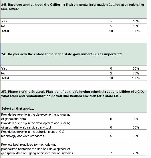
48 Pre-Workshop Survey Questions: SDI Implementation Have you used the 50 States Initiative, Imagery for the Nation, California Spatial Information Library, or the California Environmental Information Catalog at the regional or local level? Do you view the establishment of a state government GIO as important? What roles and responsibilities do you envision for a state GIO? What placement is most appropriate for a GIO?
49 CAP Grant Language and Workshop Objectives Consequently, local and regional support in creating a situation analysis is needed to provide the background for identifying current and future policy challenges associated with creating a comprehensive and integrated spatial data infrastructure. Some of the challenges may require legislative action to legitimize GIS programs and provide sustainable resources and funding.
50 Strategic Plan Outline TOC Table of Contents 1 Executive Summary 2 Strategic Planning Methodology 3 Current Situation 4 Vision and Goals 5 Requirements 6 Implementation Program 7 Appendices Strengths Existing skills Weaknesses Opportunities Threat (to implementation) Threat (if not implemented)
51 Current Situation Outline from Strategic Plan 3. Current Situation 3.1 Who are we? Who is involved, who is a stakeholder? Interests of Stakeholders Organizational Structure and Relationship to stakeholders 3.2 Where are we now? Current Organizational Structure Relationship between State and Local Governments Current Data Content and Standards 3.3 Strengths and Weaknesses 3.4 Opportunities and Threats

52 Current Situation: Technology Suitability
53 Current Situation: Funding
54 Current Situation: Staffing 50% of Regional Collaboratives have no staff available to support regional efforts.
55 Current Situation Workshop Interaction Strength Weakness Data Sharing Arrangements Lack of authority to create formal data sharing agreements Opportunity Promote awareness of value of GIS for decision making to elected officials Threat (Barrier/Constraint) Limitation of funds to build regional data sets
56 Requirements Outline from Strategic Plan 5. Requirements 5.1 Inventory of Existing Infrastructure and Suitability Assessment Current state of technology infrastructure, architecture, standards and content 5.2 Data Requirements What content needed, and at what level of accuracy and completeness Who owns data and what type of sharing agreements 5.3 Technology Requirements Necessary requirements to exchange, store, and process geospatial data What applications and required 5.4 Resource Requirements What expertise and staff is needed and already available Will these resources be consultants, fulltime, volunteers, etc. 5.5 Standards What are the relevant national and organizational standards
57 Requirements Outline from Strategic Plan 5. Requirements (continued ) 5.6 Organizational Needs Executive Support What support will you need and how will you get it Coordination and Oversight Procedures What is the current relationship and how will you work with various levels of government in this process Policy What mandates are in place and what needs to be addressed Staffing Who is needed and how will they be supported Budget Requirements What funding is needed What mechanisms are in place for cost sharing or cooperative funding Outreach and Community Development Who are we coordinating with and how Assessing Risk What are possible risks and how might they affect the process
58 Requirements: Regional SDI 25% 44% 25% 31% 38% 25% 19%
59 Requirements: Regional SDI Standards
60 Requirements Workshop Interaction: Regional Support for Statewide Data Development 1. Would your region be willing to adopt or follow statewide minimum standards? 2. What business or program processes at the regional and local levels depend on data aggregation and sharing with state and federal government agencies?


61 Requirements Workshop Interaction: Regional Support for Statewide Data Development 3. Do you see federated data efforts as feasible and desirable? What incentives do you need to participate in such efforts?
62 Implementation Outline from Strategic Plan 6. Implementation Program 6.1 Lessons Learned What case studies are available 6.2 Implementation of Sub-Projects How will sub-projects be defined and who will be responsible 6.3 Phasing and Milestones Timeline What will be completed in each phase 6.4 Budget Plan What is the necessary budget How will it be funded How will it be allocated 6.5 Marketing the Program How is the word spread Who is the target audience 6.6 Measuring Success and Recalibration What factors will be used in measuring success How do we capture cost-benefit data Do we assess progress to determine if recalibration is needed

63 Implementation: Utilization of Available Resources
64 Implementation Workshop Interaction: State Support for a CA-SDI What do you want from state government to further regional GIS efforts? What data or services would help facilitate consideration of statewide values in local land use planning decisions? What roles do you see for state and federal government agencies with regard to GIS data and services?

65 Implementation: GIS Roles & Responsibilities 60% of the Regional Collaboratives believe the GIO should be in the new office of the State s CIO.
66 Implementation Workshop Interaction: Governance 1. How might the California GIS community succeed absent a state coordinating entity like a GIO? 2. What do you need/want from the California GIS Council to further regional GIS efforts? 3. What improvements can be made to the existing California GIS Council governance structure? What s working? What s not? 4. What suggestions do you have for top priority strategies, goals and objectives for the California GIS Council that would help regional and local GIS efforts?
67 Implementation Workshop Interaction: Data & Technology 1. What value do you see in the CA-SDI for regional and local government?
68 What happens after the Workshop series?
69 Post-Workshop Steps

70 www. cgia.org
71 California GIS Strategic Plan Phase 2: Regional Participation Thank you for your Participation
State GIS Officer/GIS Data
 State GIS Officer/GIS Data This Act creates the position of state Geographic Information Systems (GIS) officer. The Act: requires the state GIS officer to adopt or veto the GIS data standards and a statewide
D2E GIS Coordination Initiative Functional Transformation Kick-Off Meeting
 D2E GIS Coordination Initiative Functional Transformation Kick-Off Meeting GIS Functional Transformation Kick-Off Meeting May 13, 2008 D2E GIS Coordination Initiative Functional Transformation Kick-Off
Section 2. Indiana Geographic Information Council: Strategic Plan
 Section 2. Indiana Geographic Information Council: Strategic Plan Introduction A geographic information system (GIS) is an automated tool that allows the collection, modification, storage, analysis, and
Spatial Data Infrastructure Concepts and Components. Douglas Nebert U.S. Federal Geographic Data Committee Secretariat
 Spatial Data Infrastructure Concepts and Components Douglas Nebert U.S. Federal Geographic Data Committee Secretariat August 2009 What is a Spatial Data Infrastructure (SDI)? The SDI provides a basis for
INSPIRE Basics. Vlado Cetl European Commission Joint Research Centre. https://ec.europa.eu/jrc/
 INSPIRE Basics Vlado Cetl European Commission Joint Research Centre https://ec.europa.eu/jrc/ Serving society Stimulating innovation Supporting legislation Outline SDI? Why European SDI? INSPIRE Policy
Ministry of Health and Long-Term Care Geographic Information System (GIS) Strategy An Overview of the Strategy Implementation Plan November 2009
 Strategy An Overview of the Strategy Implementation Plan November 2009") Ministry of Health and Long-Term Care Geographic Information System (GIS) Strategy An Overview of the Strategy Implementation Plan November 2009 John Hill, Health Analytics Branch Health System Information
Ministry of Health and Long-Term Care Geographic Information System (GIS) Strategy An Overview of the Strategy Implementation Plan November 2009 John Hill, Health Analytics Branch Health System Information
Report from the Geographic Information Coordinating Council
 Report from the Geographic Information Coordinating Council Presented by: Dr. Lee Mandell, Chair North Carolina Geographic Information Coordinating Council What is GIS? Geography plays a role in nearly
US National Spatial Data Infrastructure A Spatial Framework for Governance and Policy Development to Enable a Location-Based Digital Ecosystem
 GeoPlatform Workshop 7 Dec 2016, Department of the Interior Washington, D.C. US National Spatial Infrastructure A Spatial Framework for Governance and Policy Development to Enable a Location-Based Digital
GIS Building Communities beyond National Borders (Building Successful Spatial Data Infrastructures) Nick Land, ESRI Europe
 Nick Land, ESRI Europe") GIS Building Communities beyond National Borders (Building Successful Spatial Data Infrastructures) Nick Land, ESRI Europe UK worst flooding in the last 60 years 350,000 households without drinking water
GIS Building Communities beyond National Borders (Building Successful Spatial Data Infrastructures) Nick Land, ESRI Europe UK worst flooding in the last 60 years 350,000 households without drinking water
NEEA Refresh aka 3D Nation Requirements and Benefits Study. Allyson Jason, Carol Ostergren, Xan Fredericks and Lou Driber November 9, 2017
 + NEEA Refresh aka 3D Nation Requirements and Benefits Study Allyson Jason, Carol Ostergren, Xan Fredericks and Lou Driber November 9, 2017 + 2 Study Context Background The National Enhanced Elevation
Strategic Plan
 2013-2015 Strategic Plan April 23, 2014 Introduction The Indiana Geographic Information Council's (IGIC) 2013-2015 Strategic Plan establishes a path of action to meet opportunities and challenges of applying
U.S. Geological Survey Agency Briefing for MAPPS Mark L. DeMulder Director, National Geospatial Program. March 12, 2013
 + U.S. Geological Survey Agency Briefing for MAPPS Mark L. DeMulder Director, National Geospatial Program March 12, 2013 + 3D Elevation Program (3DEP) National Leadership The National Enhanced Elevation
Economic and Social Council
 United Nations Economic and Social Council Distr.: General 18 July 2016 Original: English Committee of Experts on Global Geospatial Information Management Sixth session New York, 3-5 August 2016 Item 2
Report on the establishment of UN GGIM: Europe Item 14. 4th session of the Committee of Experts on UN-GGIM
 Report on the establishment of UN GGIM: Europe Item 14 1 Why regional European committees of UN GGIM? In the ECOSOC resolution 2011/24 on the UN GGIM: Emphasizes the importance of promoting national, regional
Major Opportunities in Spatial Data Infrastructure Communities
 Major Opportunities in Spatial Data Infrastructure Communities Bas Kok President GSDI June 17 th 2008 FIG Working Week: Integrating Generations 14-19 June 2008 Stockholm, Sweden http://www.gsdi.org 1 GSDI
State Geographic Information Consolidation Implementation Plan
 State Geographic Information Consolidation Implementation Plan As Directed by Session Law 2008-0107 Section 6.13 Prepared By: State Chief Information Officer Geographic Information Coordinating Council
USGS National Geospatial Program Understanding User Needs. Dick Vraga National Map Liaison for Federal Agencies July 2015
 + USGS National Geospatial Program Understanding User Needs Dick Vraga National Map Liaison for Federal Agencies July 2015 + Topics 2 Background Communities of Use User Surveys National Map Liaisons Partnerships
Creating A-16 Compliant National Data Theme for Cultural Resources
 Creating A-16 Compliant National Data Theme for Cultural Resources Cultural Resource GIS Facility National Park Service John J. Knoerl Deidre McCarthy Paper 169 Abstract OMB Circular A-16 defines a set
Realizing benefits of Spatial Data Infrastructure A user s perspective from Environment Agency - Abu Dhabi
 Realizing benefits of Spatial Data Infrastructure A user s perspective from Environment Agency - Abu Dhabi Anil Kumar Director, Environment Information Management 26 April 2012 Geospatial World Forum,
Oregon Department of Transportation. Geographic Information Systems Strategic Plan
 Oregon Department of Transportation Geographic Information Systems Strategic Plan Adopted May, 2000 By the GIS Steering Committee Last printed 10/2/2012 4:20:00 PM Page Geographic Information Systems Strategic
Background Document: Report of the Regional Committee of United Nations Global Geospatial Information Management for Asia and the Pacific
 Background Document: Report of the Regional Committee of United Nations Global Geospatial Information Management for Asia and the Pacific 1. Summary 1. This report highlights the activities carried out
1. Which agency in your state is PRIMARILY responsible for archiving geospatial data and managing archived geo records? (choose one) nmlkj.
 nmlkj.") Survey Intro Kentucky, North Carolina, and Utah are partnering with the Library of Congress as part of the National Digital Information Infrastructure and Preservation Program (NDIIPP) to examine the current
Survey Intro Kentucky, North Carolina, and Utah are partnering with the Library of Congress as part of the National Digital Information Infrastructure and Preservation Program (NDIIPP) to examine the current
Oman NSDI Business Values and Future Directions. Hassan Alawi Alghazali Acting Director General National Spatial Data Infrastructure
 Oman NSDI Business Values and Future Directions Hassan Alawi Alghazali Acting Director General National Spatial Data Infrastructure Presentation Outline Geospatial Maturity Current Challenges NCSI s Role
CHAPTER 22 GEOGRAPHIC INFORMATION SYSTEMS
 CHAPTER 22 GEOGRAPHIC INFORMATION SYSTEMS PURPOSE: This chapter establishes the administration and use of to improve the quality and accessibility of Department s spatial information and support graphical
NSDI as a tool for Secure land tenure
 NSDI as a tool for Secure land tenure General Overview To look at the progress in SDI development and its application in policy formulation and impact on land tenure. INTEGRATION OF INFORMATION POLICIES
A Foundation for Coordinated GIS Minnesota s Spatial Data Infrastructure. A Strategic Plan
 A Foundation for Coordinated GIS Minnesota s Spatial Data Infrastructure A Strategic Plan Adopted by the MN Governor s Council on Geographic Information June, 2004 The Minnesota Governor's Council on Geographic
Introduction. Elevation Data Strategy. Status and Next Steps
 1 2 Introduction Elevation Data Strategy Status and Next Steps 3 Canada is the 2nd largest country in the world - 9.9 million sq km Surrounded by 3 oceans with 202 000 km of coastline Population over 35
Creating a Staff Development Plan with Esri
 Creating a Staff Development Plan with Esri Michael Green David Schneider Guest Presenter: Shane Feirer, University of California Esri UC 2014 Technical Workshop Agenda What is a Staff Development Plan?
Proposal for a DIRECTIVE OF THE EUROPEAN PARLIAMENT AND OF THE COUNCIL. establishing an infrastructure for spatial information in the Community
 Proposal for a DIRECTIVE OF THE EUROPEAN PARLIAMENT AND OF THE COUNCIL establishing an infrastructure for spatial information in the Community INSPIRE http://inspire.jrc.it/ Alessandro Annoni 1 EU Commission
What s the problem? A Modern Odyssey in Search of Relevance. The search for relevance. Some current drivers for new services. Some Major Applications
 A Modern Odyssey in Search of Relevance FIG Working Week, Athens, 24 May 2004 Paul Kelly ANZLIC Executive Director The search for relevance 1. New expectations for spatial services 2. Are we ready to meet
NSDI Implementation. Milo Robinson FGDC. U. S. Policy OMB Circular A-16 From Global GSDI To Local Canadian/ U.S. Projects
 NSDI Implementation Milo Robinson FGDC U. S. Policy OMB Circular A-16 From Global GSDI To Local Canadian/ U.S. Projects Federal Geographic Data Committee (FGDC) A US Federal Interagency committee responsible
KUNMING FORUM ON UNITED NATIONS GLOBAL GEOSPATIAL INFORMATION MANAGEMENT CITIES OF THE FUTURE: SMART, RESILIENT
 KUNMING FORUM ON UNITED NATIONS GLOBAL GEOSPATIAL INFORMATION MANAGEMENT CITIES OF THE FUTURE: SMART, RESILIENT and SUSTAINABLE Yunnan Zhenzhuang Guest House, Kunming, China 10 12 May 2017 BACKGROUND CONCEPT
Marine Spatial Planning: A Tool for Implementing Ecosystem-Based Management
 Marine Spatial Planning: A Tool for Implementing Ecosystem-Based Management Steven Murawski, Ph.D., Ecosystem Goal Team Lead National Oceanic and Atmospheric Administration NOAA November 16, 2009 1 To
Statewide Topographic Mapping Program
 Statewide Topographic Mapping Program February 28, 2018 www.dotd.la.gov Outline Purpose of the Statewide Topographic Mapping Program History Breakdown of R.S. 48:36 - Topographic Mapping Statewide Topographic
Implementing the Sustainable Development Goals: The Role of Geospatial Technology and Innovation
 Fifth High Level Forum on UN Global Geospatial Information Management Implementing the Sustainable Development Goals: The Role of Geospatial Technology and Innovation 28-30 November 2017 Sheraton Maria
The future of SDIs. Ian Masser
 The future of SDIs Ian Masser Presentation Considers two questions relating to the future development of SDIs throughout the world Where have we got to now? Where should we go from here? Identifies four
Upgrade the Datasets in NSDI for Smarter Services with the Cases of China
 Upgrade the Datasets in NSDI for Smarter Services with the Cases of China By Dr. JIANG Jie Dept of GeoInformaiton Service Platform National Geomatics Center of China October 7, 2015 Jeju, Republic of Korea
Who has the data? Results of Maryland s 3-Week Statewide GIS Inventory Challenge. This is your state. This is your inventory.
 Who has the data? Results of Maryland s 3-Week Statewide GIS Inventory Challenge This is your state. This is your inventory. Maryland s Need for GIS Inventory Maryland had no central repository for its
Brazil Paper for the. Second Preparatory Meeting of the Proposed United Nations Committee of Experts on Global Geographic Information Management
 Brazil Paper for the Second Preparatory Meeting of the Proposed United Nations Committee of Experts on Global Geographic Information Management on Data Integration Introduction The quick development of
Mapping Maine s Working Waterfront: for Our Heritage and Economy
 Mapping Maine s Working Waterfront: for Our Heritage and Economy Abstract Mapping Maine s Working Waterfronts is a collaborative project led by the Island Institute that inventories the state s current
Data Origin. Ron van Lammeren CGI-GIRS 0910
 Data Origin Ron van Lammeren CGI-GIRS 0910 How to obtain geodata? Geo data initiative Executive Order 12906, "Coordinating Geographic Data Acquisition and Access: The National Spatial Data Infrastructure,"
2018/1 The integration of statistical and geospatial information. The Regional Committee of UN-GGIM: Americas:
 The following are the conclusions and recommendations of the Regional Committee of the United Nations on Global Geospatial Information Management for the Americas, during its Fifth Session, Thursday 8
The Use of Geographic Information Systems (GIS) by Local Governments. Giving municipal decision-makers the power to make better decisions
 by Local Governments. Giving municipal decision-makers the power to make better decisions") The Use of Geographic Information Systems (GIS) by Local Governments Giving municipal decision-makers the power to make better decisions Case Study: Examples of GIS Usage by Local Governments in North
The Use of Geographic Information Systems (GIS) by Local Governments Giving municipal decision-makers the power to make better decisions Case Study: Examples of GIS Usage by Local Governments in North
Briefing. H.E. Mr. Gyan Chandra Acharya
 Briefing by H.E. Mr. Gyan Chandra Acharya Under-Secretary-General and High Representative for the Least Developed Countries, Landlocked Developing Countries and Small Island Developing States Briefing
Challenges and Potentials of Place Based Information Management in Nepal"
 Nineteenth United Nations Regional Cartographic Conference for Asia and the Pacific, Bangkok, Thailand, 29 October 1 November 2012 Challenges and Potentials of Place Based Information Management in Nepal"
Session 33: Future of GIS Minnesota GIS 2006, 2007 and Beyond
 Session 33: Future of GIS Minnesota GIS 2006, 2007 and Beyond David Arbeit, Office of Geographic and Demographic Analysis John Lally Office of Enterprise Technology Fred Logman Land Management Information
PAN AMERICAN INSTITUTE OF GEOGRAPHY AND HISTORY Specialized Organization of the OAS
 PAN AMERICAN INSTITUTE OF GEOGRAPHY AND HISTORY Specialized Organization of the OAS 10 th UNRCC Americas United Nations, New York, 20 August 2013 PAIGH, SIRGAS, PC-IDEA and GeoSUR 2013-2015 Joint Action
INSPIRE - A Legal framework for environmental and land administration data in Europe
 INSPIRE - A Legal framework for environmental and land administration data in Europe Dr. Markus Seifert Bavarian Administration for Surveying and Cadastre Head of the SDI Office Bavaria Delegate of Germany
Proposed Scope of Work Village of Farmingdale Downtown Farmingdale BOA Step 2 BOA Nomination Study / Draft Generic Environmental Impact Statement
 Proposed Scope of Work Village of Farmingdale Downtown Farmingdale BOA Step 2 BOA Nomination Study / Draft Generic Environmental Impact Statement The scope of work that follows incorporates and covers
Exploring GIS Potential for Northwestern Ontario Land Information Ontario
 Exploring GIS Potential for Northwestern Ontario Land Information Ontario May 13, 2015 The LIO Vision LIO Vision: That all geographic information about Ontario is fully integrated and accessible LIO Goal:
UN GGIM and National SDI Strategy
 MSDI Open Forum on 26 th January 2016 Contributing to the successful delivery of MSDI UN GGIM and National SDI Strategy Hiroshi Murakami Deputy Administrator Geospatial Information Authority of Japan Geospatial
Finding Common Ground Through GIS
 Finding Common Ground Through GIS Matthew Stone, MPH Special Unit for Technical Assistance Chronic Disease and Injury Control California Department of Public Health ESRI Health GIS Conference Scottsdale,
MAPPS/USGS Liaison Meeting U.S. Department of the Interior U.S. Geological Survey
 MAPPS/USGS Liaison Meeting U.S. Department of the Interior U.S. Geological Survey Kevin Gallagher, Associate Director, Core Science Systems Greg Stensaas, Earth Resources and Observation Science Center
Outline National legislative & policy context Regional history with ESSIM ESSIM Evaluation Phase Government Integration via RCCOM Regional ICOM Framew
 What MSP Implementation could change in the Maritimes Region Tim Hall, Regional Manager Oceans and Coastal Management Division Ecosystem Management Branch Fisheries and Oceans Canada Maritimes Region BIO
NSDI Policy Framework of Japan - Roles of the Private Sector in SDI -
 NSDI Policy Framework of Japan - Roles of the Private Sector in SDI - Hiroshi Murakami (GSI) Geospatial World Forum 2012 Amsterdam Background Survey Act (1949) mandates the (GSI) to develop and provide
Foundation Geospatial Information to serve National and Global Priorities
 Foundation Geospatial Information to serve National and Global Priorities Greg Scott Inter-Regional Advisor Global Geospatial Information Management United Nations Statistics Division UN-GGIM: A global
Spatial Enablement in Australian Government
 Spatial Enablement in Australian Government Chris Pigram and Greg Scott Geoscience Australia Government is facing a number of key issues and challenges today and into the future Australian Government context
RETA 6422: Mainstreaming Environment for Poverty Reduction Category 2 Subproject
 RETA 6422: Mainstreaming Environment for Poverty Reduction Category 2 Subproject A. Basic Data 1. Subproject Title: Poverty-Environment Mapping to Support Decision Making 2. Country Director: Adrian Ruthenberg
SDI Development in Georgia. Mari Khardziani Head of International Relations Unit National Agency of Public Registry
 SDI Development in Georgia Mari Khardziani Head of International Relations Unit National Agency of Public Registry Kehl, Germany September 5, 2017 2 National Agency of Public Registry Legal Entity of Public
OC Enterprise GIS. Kevin Hills, PLS Cameron Smith, GISP. OC Survey
 OC Enterprise GIS Kevin Hills, PLS Cameron Smith, GISP OC Survey Discussion Points Background & Organizational Structure of OCPW Past practices prior to Enterprise Wide GIS License (ELA) Participating
GEOGRAPHIC INFORMATION SYSTEMS Session 8
 GEOGRAPHIC INFORMATION SYSTEMS Session 8 Introduction Geography underpins all activities associated with a census Census geography is essential to plan and manage fieldwork as well as to report results
Disaster Management & Recovery Framework: The Surveyors Response
 Disaster Management & Recovery Framework: The Surveyors Response Greg Scott Inter-Regional Advisor Global Geospatial Information Management United Nations Statistics Division Department of Economic and
UN-GGIM: Strengthening Geospatial Capability
 Fifth Plenary Meeting of UN-GGIM: Europe Brussels, 6-7 June 2018 UN-GGIM: Strengthening Geospatial Capability Walking the talk to leave no one behind Greg Scott, UN-GGIM Secretariat Environmental Statistics
A Modern Odyssey in Search of Relevance
 A Modern Odyssey in Search of Relevance Paul KELLY, Australia Key words: Capacity building, GIM, spatial data infrastructure. SUMMARY A modern country has a voracious appetite for spatial information.
8 th Arctic Regional Hydrographic Commission Meeting September 2018, Longyearbyen, Svalbard Norway
 8 th Arctic Regional Hydrographic Commission Meeting 11-13 September 2018, Longyearbyen, Svalbard Norway Status Report of the Arctic Regional Marine Spatial Data Infrastructures Working Group (ARMSDIWG)
CLICK HERE TO KNOW MORE
 CLICK HERE TO KNOW MORE GeoSpace for Singapore s Whole-of-Government Data Sharing Asia GeoSpatial Forum 17 19 Oct 2011 Lee Kim Haw Singapore Land Authority Introducing Singapore Land Authority Limited
Data Origin. How to obtain geodata? Ron van Lammeren CGI-GIRS 0910
 Data Origin How to obtain geodata? Ron van Lammeren CGI-GIRS 0910 Spatial Data interest Improvement of policy making. ± 90% of all information used by government has spatial characteristics SPATIAL INFORMATION
State of Mississippi. Geospatial Strategic Plan. December 2010
 State of Mississippi Geospatial Strategic Plan December 2010 This page intentionally left blank. Mississippi Geospatial Strategic Plan December 2010 Table of Contents Mississippi Geospatial Strategic Plan
Georeferencing and Satellite Image Support: Lessons learned, Challenges and Opportunities
 Georeferencing and Satellite Image Support: Lessons learned, Challenges and Opportunities Shirish Ravan shirish.ravan@unoosa.org UN-SPIDER United Nations Office for Outer Space Affairs (UNOOSA) UN-SPIDER
EuroGeographics & INSPIRE. Nick Land, Executive Director of EuroGeographics
 EuroGeographics & INSPIRE Nick Land, Executive Director of EuroGeographics EuroGeographics A growing association 49 Members, 42 countries Topographic mapping, cadastre, land registry + Networked organisation
FIG Asia Pacific Capacity Development Network
 FIG Asia Pacific Capacity Development Network Report to the 41th General Assembly FIG Congress 2018, Istanbul - Turkey Rob Sarib Chair FIG Asia Pacific Capacity Development Network (AP CDN) Story of the
PART A Project summary
 PART A Project summary A.1 Project identification Project title Project acronym Name of the lead partner organisation in English Specific objective Demonstrattion AF DAF Partner 1.1. Improving innovation
Water Data Sharing an Update
 Water Data Sharing an Update By David R. Maidment Leader, CUAHSI Hydrologic Information System Project and Director, Center for Research in Water Resources, University of Texas at Austin Prepared for Subcommittee
Spatially Enabled Society
 International Seminar on Land Administration Trends and Issues in Asia and the Pacific Region Spatially Enabled Society Abbas Rajabifard Vice Chair PCGIAP-WG3 Vice-President (President Elect), GSDI Association
Building a National Data Repository
 Building a National Data Repository Mladen Stojic, Vice President - Geospatial 1/30/2013 2012 Intergraph Corporation 1 Information has meaning and gives power only when shared and distributed. Information,
GIS Geographical Information Systems. GIS Management
 GIS Geographical Information Systems GIS Management Difficulties on establishing a GIS Funding GIS Determining Project Standards Data Gathering Map Development Recruiting GIS Professionals Educating Staff
Pacific Geospatial and Surveying Council (PGSC) Geospatial and GNSS CORS Infrastructure Forum. Kuala Lumpur October
 Geospatial and GNSS CORS Infrastructure Forum. Kuala Lumpur October") Pacific Geospatial and Surveying Council (PGSC) Geospatial and GNSS CORS Infrastructure Forum. Kuala Lumpur 16-17 October Beginning and Progress Members PGSC Charter PGSC Strategy 2017-2027 Meetings Geodetic
Pacific Geospatial and Surveying Council (PGSC) Geospatial and GNSS CORS Infrastructure Forum. Kuala Lumpur 16-17 October Beginning and Progress Members PGSC Charter PGSC Strategy 2017-2027 Meetings Geodetic
GENERAL RECOMMENDATIONS. Session 7. Breakout discussion. discuss on regional and interregional. proposals 1. COLLABORATION BETWEEN PROGRAMMES
 Session 7 24 July 2016, 9.00-11.00 Breakout discussion on regional and interregional joint project proposals Mr Shahbaz Khan summarized the two days of presentations and exchanges and requested the participants
Turkey s National SDI Implementation
 Onur PAŞAOĞULLARI Head of Department Turkey s National SDI Implementation Presentation Plan NSDI Background General Directorate of Geographic Information Systems NSDI Project INSPIRE Directive Urban Information
The National Spatial Strategy
 Purpose of this Consultation Paper This paper seeks the views of a wide range of bodies, interests and members of the public on the issues which the National Spatial Strategy should address. These views
Philippines NSDI Foundation Data Program. Andrew Bashfield
 Philippines NSDI Foundation Data Program Andrew Bashfield 1 Overview Part 1: Building the NSDI Framework Part 2: Collecting Foundation Datasets 2 Building the NSDI Framework Background & NDSI Overview
UN COMMITTEE OF EXPERTSON GLOBAL GEOSPATIAL INFORMATION MANAGEMENT. August 13 15, 2012 COUNTRY REPORT OF THE PHILIPPINES
 UN COMMITTEE OF EXPERTSON GLOBAL GEOSPATIAL INFORMATION MANAGEMENT August 13 15, 2012 COUNTRY REPORT OF THE PHILIPPINES National Mapping and Resource Information Authority Department of Environment and
Economic and Social Council
 United Nations Economic and Social Council Distr.: General 2 July 2012 E/C.20/2012/10/Add.1 Original: English Committee of Experts on Global Geospatial Information Management Second session New York, 13-15
Regional GIS Initiatives Geospatial Technology Center
 Regional GIS Initiatives Geospatial Technology Center Mr. Bobby Lear GIS Coordinator St. James Parish & Dr. Balaji Ramachandran Contractors Educational Trust Fund Endowed Professor Geomatics Program, Department
Geospatial Information Management, a Feasible Tool for Small Island Developing States?
 Geospatial Information Management, a Feasible Tool for Small Island Developing States? Hartmut Müller FIG Pacific Small Island Developing States Symposium, Policies and Practices for Responsible Governance
Aboriginal communities strengthen governance with location-based tools in the 21st century
 Aboriginal communities strengthen governance with location-based tools in the 21st century Today, Aboriginal communities are taking advantage of the geomatics technologies that underpin popular online
Establishing the National Spatial Data Infrastructure (NSDI) for Norway a joint effort by many stakeholders SPATIAL DATA FOR BENEFIT OF THE SOCIETY
 for Norway a joint effort by many stakeholders SPATIAL DATA FOR BENEFIT OF THE SOCIETY") Establishing the National Spatial Data Infrastructure (NSDI) for Norway a joint effort by many stakeholders SPATIAL DATA FOR THE BENEFIT OF SOCIETY OUTLINE Political background Norway digital - The Norwegian
Establishing the National Spatial Data Infrastructure (NSDI) for Norway a joint effort by many stakeholders SPATIAL DATA FOR THE BENEFIT OF SOCIETY OUTLINE Political background Norway digital - The Norwegian
THE ROLE OF GEOSPATIAL AT THE WORLD BANK
 THE ROLE OF GEOSPATIAL AT THE WORLD BANK INSPIRE Conference Barcelona, Spain September 26, 2016 Kathrine Kelm Senior Land Administration Specialist Global Land and Geospatial Unit The World Bank Group
Topographic Mapping in Australia: The Future State
 Topographic ping in Australia: The Future State Context Australia s geography and demography Greg Scott Group Leader National ping & Information Group Chair Permanent Committee for Topographic Information
THE SEVILLE STRATEGY ON BIOSPHERE RESERVES
 THE SEVILLE STRATEGY ON BIOSPHERE RESERVES 1 VISION FOR BIOSPHERE RESERVES IN THE 21 ST CENTURY The international Seville Conference on Biosphere Reserves, organised by UNESCO, adopted a two-pronged approach,
ACTION PLAN FOR WORLD HERITAGE IN LATIN AMERICA AND THE CARIBBEAN ( )
") Annex ACTION PLAN FOR WORLD HERITAGE IN LATIN AMERICA AND THE CARIBBEAN (2014-2024) The current Regional Action Plan for Latin America and the Caribbean for 2014-2024 has been elaborated by the State Parties
Annex ACTION PLAN FOR WORLD HERITAGE IN LATIN AMERICA AND THE CARIBBEAN (2014-2024) The current Regional Action Plan for Latin America and the Caribbean for 2014-2024 has been elaborated by the State Parties
Report of the Regional Committee of UN-GGIM for Asia and the Pacific (UN-GGIM-AP)
") Report of the Regional Committee of UN-GGIM for Asia and the Pacific (UN-GGIM-AP) At the Eighth Session of UN-GGIM UN Headquarters, New York, 1 3 August 2018 About UN-GGIM-AP One of the five regional committees
Report of the Regional Committee of UN-GGIM for Asia and the Pacific (UN-GGIM-AP) At the Eighth Session of UN-GGIM UN Headquarters, New York, 1 3 August 2018 About UN-GGIM-AP One of the five regional committees
DRAFT PROGRAM Registration of participants, welcome coffee, exhibition tour
 DRAFT PROGRAM 20 Feb 2018 09.00-10.00 Registration of participants, welcome coffee, exhibition tour 10.00 12.00 ROUND TABLE: INTERNATIONAL COOPERATION IN THE ARCTIC PROJECTS: CHALLENGES AND OPPORTUNITIES
Oregon Department of Transportation. Geographic Information Systems. Implementation Plan. Adopted November, 2000 By the GIS Steering Committee
 Oregon Department of Transportation Geographic Information Systems Implementation Plan Adopted November, 2000 By the GIS Steering Committee Introduction The Oregon Department of Transportation (ODOT) GIS
a national geological survey perspective François ROBIDA BRGM (French Geological Survey)
") a national geological survey perspective François ROBIDA BRGM (French Geological Survey) Pre-Conference Seminar on Socio-Economic Value of Geospatial for National and Regional Development 21 August 2017,
a national geological survey perspective François ROBIDA BRGM (French Geological Survey) Pre-Conference Seminar on Socio-Economic Value of Geospatial for National and Regional Development 21 August 2017,
TOWARDS CLIMATE-RESILIENT COASTAL MANAGEMENT: OPPORTUNITIES FOR IMPROVED ICZM IN BELIZE
 TOWARDS CLIMATE-RESILIENT COASTAL MANAGEMENT: OPPORTUNITIES FOR IMPROVED ICZM IN BELIZE CHANTALLE SAMUELS Coastal Zone Management Authority and Institute The Caribbean Community Climate Change Centre VULNERABILITY
Challenges and Successes in Sharing Geospatial Data in Africa
 Challenges and Successes in Sharing Geospatial Data in Africa 2018 GeoNode Summit Torino, Italy March 26-28, 2018 Bernard Justus Muhwezi Manager, Geo-Information Services Uganda Bureau of Statistics, Kampala,
MARINE SPATIAL PLANNING & MARINE CADASTRE: CHALLENGES AND ISSUES
 MARINE SPATIAL PLANNING & MARINE CADASTRE: CHALLENGES AND ISSUES Roger Longhorn Secretary General, GSDI Association rlonghorn@gsdi.org Member, IHO Marine SDI Working Group ral@alum.mit.edu Member, UNESCO
Concept Formulation of Geospatial Infrastructure. Hidenori FUJIMURA*
 Concept Formulation of Geospatial Infrastructure 1 Concept Formulation of Geospatial Infrastructure Hidenori FUJIMURA* (Published online: 28 December 2016) Abstract Technical trends in the field of surveying
Disaster Management in Mongolia
 The Third UN-GGIM-AP Plenary Meeting Disaster Management in Mongolia ~Coordination among NGIA & Other Related Organizations and Recommendations~ Bali Indonesia 10 November 2014 Khurelshagai Ayurzana, Director