Where
|
|
|
- Jerome Franklin
- 5 years ago
- Views:
Transcription
1


2 Where


3 What

4 Past
5
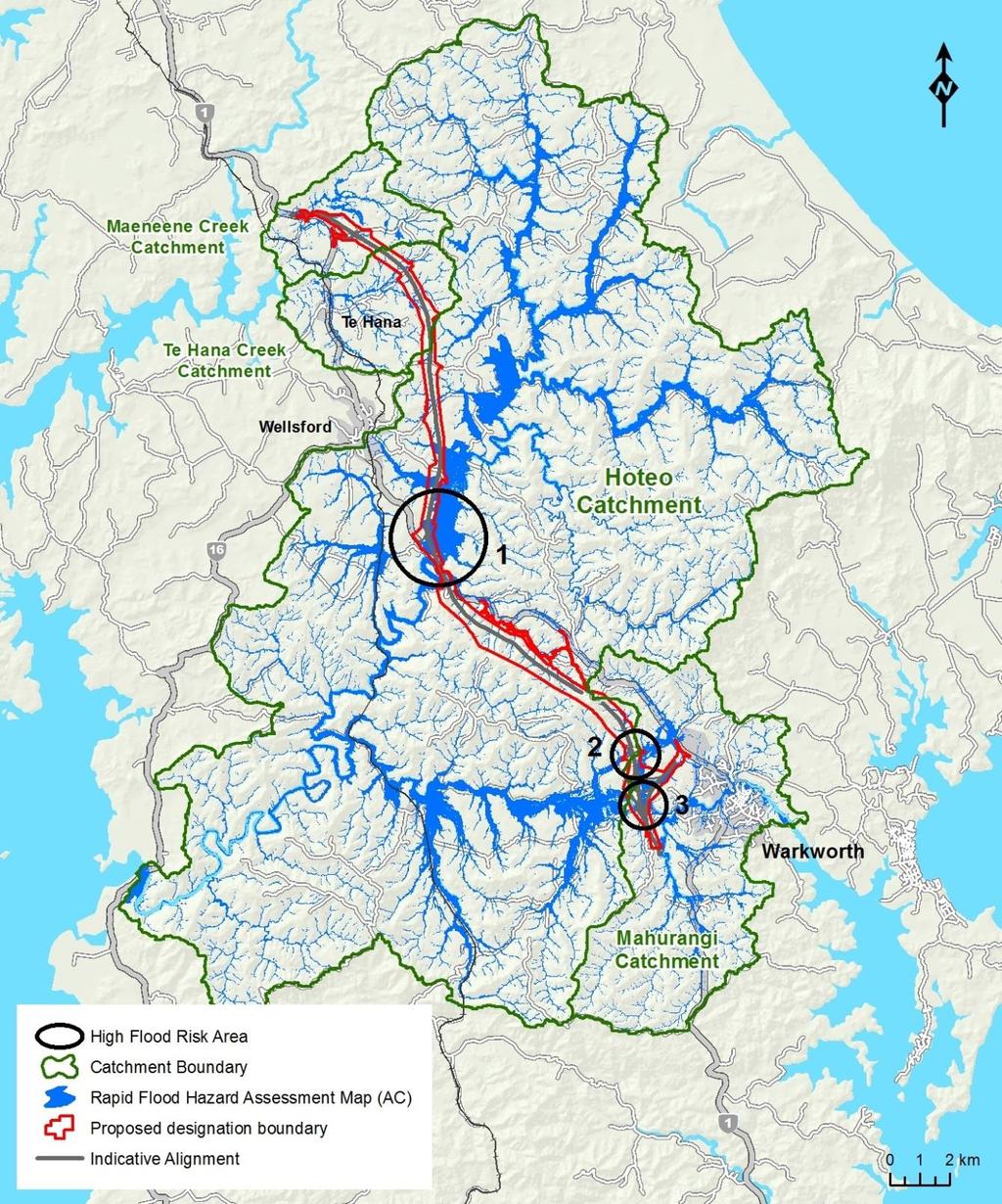
6 Updated Construction Parameters Assumed start date year bulk EW duration plus approx. 1 year enabling works and early construction activities Enabling and early activities includes activities such as vegetation clearance, relocation of utilities, site investigations, site establishment, access roads and haul roads, trial embankments, provision of initial ESC Total earthworks footprint of approx. 310ha Potential soil disposal site areas = 85 ha 12.3 m m 3 of Cut and 9.6 m m 3 of fill 0.64 m m 3 imported material with 3.4 m m 3 to go to spoil sites Approximately 45% (139.5 ha) of the overall earthworks footprint area is steeper than 10 degrees (Pakiri Formation) south of the Hoteo River, and the Northland Allochthon (formerly known as Onerahi Chaos) rocks to the north of the Hoteo River
7 Updated Construction Parameters Catchment Construction area Total earthwork area (ha) Peak active summer earthworks (ha) Mahurangi River Hoteo River Kourawhero Stream Waiteraire Stream Hoteo River & unnamed tributaries Yr 1 Yr 2 Yr 3 Yr 4 Yr 5 Yr 6 Mahurangi Operation Operation Operation Operation Total Operation Operation Operation Total Total Oruawharo River Te Hana Creek Oruawharo Maeneene Creek Oruawharo Total

8
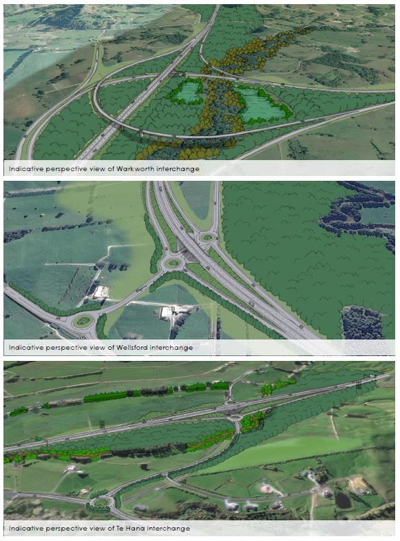
9 Statutory process Consents and designation One Notice of Requirement which may overlay existing NZTA designations at common points eg near Warkworth, to facilitate the Wellsford and Te Hana interchanges Designation conditions including construction and operation
10 Resource consents Earthworks (including in SEAs and SCPAs, and area and quantity) RDA Vegetation alteration and removal (including in SEAs, riparian zones and rural zones) RDA Works in watercourses Discretionary Diversions of intermittent and permanent watercourses discretionary Note none in overlays Diversion of groundwater tunnel and large cuts RDA Diversion and discharge of stormwater runoff RDA High use road section 9 consent controlled activity Air discharge mineral rock crushing - RDA

11 Water

12 Rocks

13

14

15 Landscape

16 Southern Warkworth

17 Central Dome

18 Northern Hoteo

19 North Wellsford
20 Terrestrial Ecology Small, low value wetland features are interspersed throughout the landscape, generally degraded due to stock access. High value mosaic of wetlands/remnant vegetation in upper Kourawhero Stream catchment Pine forest dominates Dome Valley forest. Construction follows forest harvesting Remnant patches of lowland forest including the totara-dominated forest lining the Hoteo River, and patches of kahikatea swamp forest and taraire forest on higher ground.

21 Small, low value wetlands


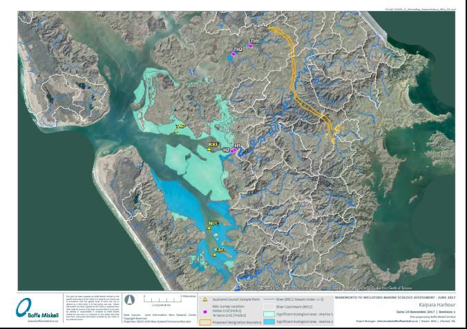
22 Small, low value wetlands

23 High value mosaic of wetlands/remnant vegetation

24 High quality lowland forest

 catchment boundary; fauna and seed dispersal route. Planting of vegetation.")
25 Terrestrial Ecology Management Fauna habitat and flyway mitigation 83.4 ha of existing retained and managed pine forest; above tunnel; alongside natural escarpment. Purpose is to retain old growth vegetation for roost and breeding sites for bats and birds; potential relocation site for salvaged fauna. Managed vegetation regrowth. Pest and weed management/stock exclusion. Fragmentation/connectivity/edge effects 17.3 ha Purpose is to mitigate for the fragmentation of sites. Provides N-S connection, crosses Mahurangi River and Kourawhero Stream (Hoteo River) catchment boundary; fauna and seed dispersal route. Planting of vegetation. Pest and weed management/stock exclusion. Fauna management (incl. Hochstetter Frogs)
26 Mahu Koura Hoteo Te Hana Mahu Koura Hoteo Te Hana Vegetation loss and proposed mitigation Vegetation type Value Total Ratio Total Podocarp/ scrub H-VH Remainder L-M TOTAL Wetlands H-VH Wetlands L-M TOTAL TOTAL ALL
27 Freshwater Ecology Assessment Overall balance of streams to be mitigated (from indicative alignment) Estimated loss of permanent and intermittent streams of 27.1 km. Approximately 18.3 km of stream diversions (equivalent habitat) On balance, mitigation required for approximately 8.8 km of stream loss Following the SEV and ECR protocols the mitigation required within the different sections are: Warkworth North: 10.1 km (of 26.8 km of available habitat) Dome Valley Forest: 24.9 km (of 38.5 km of available habitat) Hoteo North: 36 km (of 52.8 km of available habitat)
28 Key assessment results Mahurangi River (existing) water quality is generally good, however there are slightly elevated concentration of phosphorus and turbidity/suspended sediments Hoteo River (existing) has turbidity/suspended sediments that are elevated above the guideline values for the majority of the time and phosphorus concentrations are slightly elevated. Forestry felling (not Project) has much greater influence on hydrology (peak flows) than the Project and needs to be consider in design
29 Marine Ecology Ultimate receiving environment muddy upper harbour estuarine depositional habitats of Kaipara and Mahurangi Harbours Distant from the Project earthworks High baseline sediment loads Benthic invertebrate assemblages reflect high sedimentation But, receiving environments are SEA M1 areas and AUP requires activities do not contribute to cumulative degradation of SEA M1 areas Stakeholder groups in Kaipara and Mahurangi focussed on reducing sediment loads to the harbours
30 Marine Monitoring and Mitigation No direct discharges to the CMA Best practice ESCP s will be in place and usual monitoring at freshwater receiving locations would occur Monitoring in upper harbour receiving environments during construction would not assist with determining the effects of the Project inconclusive, cannot separate existing discharges from Project Recommend no monitoring of effects of rainfall events on estuarine ecology and no annual monitoring But, recommend mitigation of the Project s potential contribution to sedimentation of the harbours both through acute events and chronic contributions to long term sedimentation (cumulative effect) Measure and mitigate the actual sediment contribution (against our modelling calculations) during construction of the Project. Offset through potential for retirement of land and and planting to reduce long term sediment loads to return an ongoing net benefit within c years after construction.


31 Structures
32
33

34

35

36
37
fauna ecological unit
 fauna The forested area of this site was surveyed by the NZ Wildlife Service, Fauna Survey Unit in 1977 (SSBI Q08/H012); however, no fauna observations were made. This site is dominated by a relatively
Biodiversity Blueprint Overview
 Biodiversity Blueprint Overview Climate Variability Climate projections for the Glenelg Hopkins Regions suggest that the weather will be hotter and drier in the coming years which will impact on land use,
Kakahu Catchment Group. Sub-Catchment Plan Recommendations to Zone Committee
 Kakahu Catchment Group Sub-Catchment Plan Recommendations to Zone Committee About our catchment Part of the Temuka nutrient allocation zone (red) State of the Environment testing showed the Lower Kakahu
Coastal Environment. Introduction. 4.1 Coastal Environment. Extent of Coastal Environment
 4 The primary objective (set out in Chapter 2) to be implemented by this Chapter is Objective 2.4 ; the following objectives are also relevant due to the objectives integrated nature: 2.1 Tāngata whenua
Gully Erosion Part 1 GULLY EROSION AND ITS CAUSES. Introduction. The mechanics of gully erosion
 Gully Erosion Part 1 GULLY EROSION AND ITS CAUSES Gully erosion A complex of processes whereby the removal of soil is characterised by incised channels in the landscape. NSW Soil Conservation Service,
The Refugia Concept: Using Watershed Analysis to Prioritize Salmonid Habitat for Conservation and Restoration
 The Refugia Concept: Using Watershed Analysis to Prioritize Salmonid Habitat for Conservation and Restoration Christopher May Battelle & UW Cumulative Impacts of Urbanization Landscape Alterations Loss
AUCKLAND MOTORWAY EXTENSION NORTHLAND REGION, NEW ZEALAND
 LEAPFROG WORKS 1 CASE STUDY Case Study: Tonkin & Taylor and Beca Design JV Puhoi to Warkworth motorway AUCKLAND MOTORWAY EXTENSION NORTHLAND REGION, NEW ZEALAND 2 The 3D subsurface model encompasses the
Northland Regional Landscape Assessment Worksheet
 Northland Regional Landscape Assessment Worksheet DESCRIPTION AND CHARACTERISATION Component Land Types (refer to list overleaf) Ranges; high relief Unit name HEREKINO BUSH-CLAD HILLS Comment A large,
Use of benthic invertebrate biological indicators in evaluating sediment deposition impairment on the Middle Truckee River, California
 Use of benthic invertebrate biological indicators in evaluating sediment deposition impairment on the Middle Truckee River, California David B. Herbst Sierra Nevada Aquatic Research Laboratory University
Sediment and nutrient transport and storage along the urban stream corridor
 Sediment and nutrient transport and storage along the urban stream corridor Greg Noe, Cliff Hupp, Ed Schenk, Jackie Batson, Nancy Rybicki, Allen Gellis What is the role of floodplains everywhere? Noe 2013,
GIS data classes used within the November 2013 Environmental Statement Engineering Maps
 LWM-HS2-EN-DAT-000-000001 P01 22 January 2014 GIS data classes used within the November 2013 Environmental Statement Engineering Maps Document No.:LWM-HS2-EN-DAT-000-000001 Revision Author Checked by Approved
Appendix K.2: Sediment Management Excerpt from South Orange County Hydromodification Management Plan
 Appendix K.2: Sediment Management Excerpt from South Orange County Hydromodification Management Plan 4 Sediment Supply Management Requirements Permit Order R9-2013-0001 as amended by Order No. R9-2015-0001Section
Statement of Impact and Objectives. Watershed Impacts. Watershed. Floodplain. Tumblin Creek Floodplain:
 Tumblin Creek Floodplain: Impacts Assessment and Conceptual Restoration Plan Casey A. Schmidt Statement of Impact and Objectives Urbanization has increased stormflow rate and volume and increased sediment,
24.0 Mineral Extraction
 Chapter 24 - Mineral Extraction 24.0 Mineral Extraction 24.1 Introduction Apart from gravel, sand, rock, limestone and salt extraction in relatively small quantities mineral extraction is not a strong
APPENDIX E. GEOMORPHOLOGICAL MONTORING REPORT Prepared by Steve Vrooman, Keystone Restoration Ecology September 2013
 APPENDIX E GEOMORPHOLOGICAL MONTORING REPORT Prepared by Steve Vrooman, Keystone Restoration Ecology September 2 Introduction Keystone Restoration Ecology (KRE) conducted geomorphological monitoring in
POUTUKITERANGI PA FOREST REMNANT
 Valley-fill swamp and alluvium in coastal hill country of Waipapa Terrane greywacke (a) Raupo-dominant fertile wetland The wetland is surrounded by pasture except for a small buffer of manuka, totara,
Nutrient and Sediment Cycling and Retention in Urban Floodplain Wetlands
 Nutrient and Sediment Cycling and Retention in Urban Floodplain Wetlands Greg Noe, Cliff Hupp, Nancy Rybicki, Ed Schenk, and Jackie Batson National Research Program, Reston VA U.S. Department of the Interior
Through their research, geographers gather a great deal of data about Canada.
 Ecozones What is an Ecozone? Through their research, geographers gather a great deal of data about Canada. To make sense of this information, they often organize and group areas with similar features.
Natural Resource Management Strategy. Southern Tasmania. Summary. Natural Resource Management Strategy for Southern Tasmania Summary
 Natural Resource Management Strategy Summary Southern Tasmania 2015 2020 Natural Resource Management Strategy for Southern Tasmania 2015 2020 - Summary i Disclaimer In developing this Strategy, every effort
Channel Assessments of Selected Watersheds within TFL 52
 Channel Assessments of Selected Watersheds within TFL 52 prepared for: West Fraser Mills Ltd. Quesnel, BC prepared by: John Berry, M.Sc., R.P.F. Victoria, BC Channel Assessments TFL 52 Summary SUMMARY
Northland Regional Landscape Assessment Worksheet
 Northland Regional Landscape Assessment Worksheet Unit name MANGATIPA DESCRIPTION AND CHARACTERISATION Component Land Types (refer to list overleaf) Volcanic cone (remains). Steep hills: moderate high
Carbon Sequestration Potential from Coastal Wetlands Restoration Sites
 Carbon Sequestration Potential from Coastal Wetlands Restoration Sites Insert then choose Picture select your picture. Right click your picture and Send to back. Paul Krause, Alyssa Beach Emily Cooper,
What is a watershed or landscape perspective?
 What is a watershed or landscape perspective? -remove sediment -add sediment -add wood, riparian manipulation -alter (engineer) channel/floodplain morphology -restore/abandon roads You are here What is
Survey no. Q06/111 Survey date 30 April 1997 Grid reference Q ha (153 ha estuary, 53 ha wetland) Altitude sea level
 Altitude sea level") HORAHORA ESTUARY Survey no. Q06/111 Survey date 30 April 1997 Grid reference Q06 456 139 Area 206 ha (153 ha estuary, 53 ha wetland) Altitude sea level Ecological unit (a) Mangrove forest on estuary (b)
HORAHORA ESTUARY Survey no. Q06/111 Survey date 30 April 1997 Grid reference Q06 456 139 Area 206 ha (153 ha estuary, 53 ha wetland) Altitude sea level Ecological unit (a) Mangrove forest on estuary (b)
SPECIFIC DEGRADATION AND RESERVOIR SEDIMENTATION. By Renee Vandermause & Chun-Yao Yang
 SPECIFIC DEGRADATION AND RESERVOIR SEDIMENTATION By Renee Vandermause & Chun-Yao Yang Outline Sediment Degradation - Erosion vs Sediment Yield - Sediment Yield - Methods for estimation - Defining Sediment
GOAL 7 AREAS SUBJECT TO NATURAL DISASTERS AND HAZARDS. To protect life and property from natural disasters and hazards.
 GOAL 7 AREAS SUBJECT TO NATURAL DISASTERS AND HAZARDS A. GOALS: To protect life and property from natural disasters and hazards. B. POLICIES: 1. Floodplains shall be maintained as natural drainage-ways.
Natural Shoreline Landscapes on Michigan Inland Lakes
 Natural Shoreline Landscapes on Michigan Inland Lakes Excerpts from Chapters 2 and 3 Photo Photo by Jane by Jane Herbert Herbert Did you know? Twenty-four species of amphibians, 25 species of reptiles,
Northland Regional Landscape Assessment Worksheet
 Northland Regional Landscape Assessment Worksheet Unit name HURUPAKI VOLCANIC CONE DESCRIPTION AND CHARACTERISATION Component Land Types Volcanic cones land type Comment One of a sequence of volcanic cones,
Ground Water Control of Tree Island Origin, Genesis and Destruction. By John F. Meeder and Peter W. Harlem SERC,FIU
 Ground Water Control of Tree Island Origin, Genesis and Destruction By John F. Meeder and Peter W. Harlem SERC,FIU Functional Definition Our functional definition of a Tree Island is; an isolated scrub
Environmental Statement South Kyle Wind Farm August Appendix 12.9: The Habitat Loss and Disturbance Calculations
 Appendix 12.9: The Habitat and Disturbance Calculations 1.1 Introduction 1 This appendix details the approach, assumptions and results of the process adopted to quantify habitat loss and degradation as
Flow regime, floodplain inundation and floodplain waterbody connectivity at Congaree National Park
 Flow regime, floodplain inundation and floodplain waterbody connectivity at Congaree National Park John Kupfer Dept. of Geography Univ. of South Carolina Kimberly Meitzen Duke University Nature Conservancy
AP ENVIRONMENTAL SCIENCE 2013 SCORING GUIDELINES [14 pt space] Question 1
![AP ENVIRONMENTAL SCIENCE 2013 SCORING GUIDELINES [14 pt space] Question 1](/thumbs/77/74883235.jpg "AP ENVIRONMENTAL SCIENCE 2013 SCORING GUIDELINES [14 pt space] Question 1") AP ENVIRONMENTAL SCIENCE 2013 SCORING GUIDELINES [14 pt space] Question 1 (a) Identify TWO human activities that alter the natural flow of sediments into Gulf Coast ecosystems. Explain how each of the
AP ENVIRONMENTAL SCIENCE 2013 SCORING GUIDELINES [14 pt space] Question 1 (a) Identify TWO human activities that alter the natural flow of sediments into Gulf Coast ecosystems. Explain how each of the
Savannah District s Revised SOP: Moving Towards A Functional Approach. US Army Corps of Engineers BUILDING STRONG
 Savannah District s Revised SOP: Moving Towards A Functional Approach US Army Corps of Engineers Agenda SOP Revision Concept New Aquatic Resource Credit Types New Urban Mitigation Service Area Filter Background
Dam Removal Analysis Guidelines for Sediment
 A review of: Dam Removal Analysis Guidelines for Sediment Joe Rathbun (Retired) rathbunj@sbcglobal.net Some Potential Sediment Issues Reservoir restoration Downstream water quality Downstream deposition
Rock Sizing for Bank Stabilisation
 Rock Sizing for Bank Stabilisation WATERWAY MANAGEMENT PRACTICES Photo 1 Lower bank rock stabilisation with voids filled with small rocks Photo 2 Rock stabilisation with plants introduced at time of rock
Biosphere Biome Ecosystem Community Population Organism
 Ecology ecology - The study of living things and how they relate to their environment Levels of Organization in Ecology organism lowest level one living thing population collection of organisms of the
Pee Dee Explorer. Science Standards
 Science Standards About Pee Dee Explorer What does it mean when someone says they are from the "Pee Dee" of South Carolina? A place is bigger than its physical geography. A "sense of place" weaves together
Adaptation to Sea Level Rise A Regional Approach
 Adaptation to Sea Level Rise A Regional Approach Project Partners: in Saco Bay, ME Peter Slovinsky, Marine Geologist Maine Geological Survey, Department of Conservation Project Funding from: Saco Bay Hazards
Mahurangi Land-Use Scenario Modelling
 Mahurangi Land-Use Scenario Modelling April TR 2009/042 Auckland Regional Council Technical Report No.042 April 2009 ISSN 1179-0504 (Print) ISSN 1179-0512 (Online) ISBN 978-1-877528-51-4 This report is
EFFECTS OF RIPARIAN RETENTION (IN WATERSHEDS) ON ALLUVIAL FANS
 ON ALLUVIAL FANS") EFFECTS OF RIPARIAN RETENTION (IN WATERSHEDS) ON ALLUVIAL FANS TIM GILES GEOMORPHOLOGIST FLNRO EFFECTS OF RIPARIAN RETENTION (IN WATERSHEDS) ON ALLUVIAL FANS Description of alluvial fans Three case studies
EFFECTS OF RIPARIAN RETENTION (IN WATERSHEDS) ON ALLUVIAL FANS TIM GILES GEOMORPHOLOGIST FLNRO EFFECTS OF RIPARIAN RETENTION (IN WATERSHEDS) ON ALLUVIAL FANS Description of alluvial fans Three case studies
Watershed Processes and Modeling
 Watershed Processes and Modeling Pierre Y. Julien Hyeonsik Kim Department of Civil Engineering Colorado State University Fort Collins, Colorado Kuala Lumpur - May Objectives Brief overview of Watershed
Earth s Major Terrerstrial Biomes. *Wetlands (found all over Earth)
") Biomes Biome: the major types of terrestrial ecosystems determined primarily by climate 2 main factors: Depends on ; proximity to ocean; and air and ocean circulation patterns Similar traits of plants
Biomes Biome: the major types of terrestrial ecosystems determined primarily by climate 2 main factors: Depends on ; proximity to ocean; and air and ocean circulation patterns Similar traits of plants
Use of Bioengineering Techniques for Revegetation of Riparian Areas: Colomac Mine Remediation Project, NWT
 Use of Bioengineering Techniques for Revegetation of Riparian Areas: Colomac Mine Remediation Project, NWT McPherson, M. 1, Vanderspiegel, R. 2, Breadmore, R. 2, and Hewitt, M. 3 2012 RPIC Federal Contaminated
ADDRESSING GEOMORPHIC AND HYDRAULIC CONTROLS IN OFF-CHANNEL HABITAT DESIGN
 ADDRESSING GEOMORPHIC AND HYDRAULIC CONTROLS IN OFF-CHANNEL HABITAT DESIGN Conor Shea - Hydrologist U.S. Fish and Wildlife Service Conservation Partnerships Program Arcata, CA Learning Objectives Examine
STREUVER FIDELCO CAPPELLI, LLC YONKERS DOWNTOWN DEVELOPMENT PHASE 1. DRAFT ENVIRONMENTAL IMPACT STATEMENT For: PALISADES POINT
 STREUVER FIDELCO CAPPELLI, LLC YONKERS DOWNTOWN DEVELOPMENT PHASE 1 DRAFT ENVIRONMENTAL IMPACT STATEMENT For: PALISADES POINT Prepared by: PAULUS, SOKOLOWSKI & SARTOR STORMWATER MANAGEMENT 1. Methodology
Which map shows the stream drainage pattern that most likely formed on the surface of this volcano? A) B)
 B)") 1. When snow cover on the land melts, the water will most likely become surface runoff if the land surface is A) frozen B) porous C) grass covered D) unconsolidated gravel Base your answers to questions
1. When snow cover on the land melts, the water will most likely become surface runoff if the land surface is A) frozen B) porous C) grass covered D) unconsolidated gravel Base your answers to questions
Restoring river-floodplain interconnection and riparian habitats along the embanked Danube between Neuburg and Ingolstadt (Germany)
") Restoring river-floodplain interconnection and riparian habitats along the embanked Danube between Neuburg and Ingolstadt (Germany) Dipl.-Geogr. Gerald Blasch Department of Physical Geography, Cath. University
Restoring river-floodplain interconnection and riparian habitats along the embanked Danube between Neuburg and Ingolstadt (Germany) Dipl.-Geogr. Gerald Blasch Department of Physical Geography, Cath. University
Ms. A. Mormando's Class *
 8 th Grade Science Essential Standard: 8.E.1.1 Explain the structure of the hydrosphere including: Water distribution on Earth; Local river basin and water availability Stream - A stream is a body of water
Swift Creek Sediment Management Action Plan (SCSMAP)
") Swift Creek Sediment Management Action Plan (SCSMAP) PHASE 3 PROJECT PLAN PROPOSAL Whatcom County Public Works Department 322 N. Commercial Street, Suite 210 Bellingham, WA 98225 (360) 676-6692 June 2013
Swift Creek Sediment Management Action Plan (SCSMAP) PHASE 3 PROJECT PLAN PROPOSAL Whatcom County Public Works Department 322 N. Commercial Street, Suite 210 Bellingham, WA 98225 (360) 676-6692 June 2013
Defining the Limit of Regulated Areas. C.1 Defining the River or Stream Flood Hazard 138. C.2 Defining the River or Stream Erosion Hazard 139
 C.1 Defining the River or Stream Flood Hazard 138 C.2 Defining the River or Stream Erosion Hazard 139 C.3 Defining Watercourses 141 C.4 Defining the Lake Ontario Shoreline Flood, Erosion and Dynamic Beach
Environmental Science
 Environmental Science A Study of Interrelationships Cui Jiansheng Hebei University of Science and Technology CH06 Kinds of Ecosystems and Communities Chapter Objectives After reading this chapter, you
Hydrologic hazards can be considered in three categories; An indication of flooding potential for areas located
 4.0 General Hydrologic Design Critera 4.1 Hydrologic Hazards Hydrologic hazards can be considered in three categories; flooding, channel migration, and tributary stajility. An indication of flooding potential
PROCEDURES FOR ASSESSING PROPOSED BUILDINGS AND SUBDIVISIONS, AND TREES, AFFECTED BY AIRFIELD HEIGHT RESTRICTIONS
 APPENDIX 1 PROCEDURES FOR ASSESSING PROPOSED BUILDINGS AND SUBDIVISIONS, AND TREES, AFFECTED BY AIRFIELD HEIGHT RESTRICTIONS 1. The height restrictions affect a considerable number of properties within
Duralie Open Pit Modification
 Duralie Open Pit Modification Environmental Assessment SECTION 5 REHABILITATION STRATEGY TABLE OF CONTENTS 5 REHABILITATION STRATEGY 5-1 5.1 EXISTING DCM REHABILITATION 5-1 5.1.1 Rehabilitation Principles
Factors influencing nutrient and sediment retention by riverine wetlands in the Chesapeake watershed Greg Noe, Cliff Hupp, Ed Schenk, Nancy Rybicki
 Factors influencing nutrient and sediment retention by riverine wetlands in the Chesapeake watershed Greg Noe, Cliff Hupp, Ed Schenk, Nancy Rybicki National Research Program, Reston VA U.S. Department
RANGE AND ANIMAL SCIENCES AND RESOURCES MANAGEMENT - Vol. II - Catchment Management A Framework for Managing Rangelands - Hugh Milner
 CATCHMENT MANAGEMENT A FRAMEWORK FOR MANAGING RANGELANDS Hugh Milner International Water Management Consultant, Australia Keywords: Rangeland management; catchments and watersheds; catchment management
How Do Human Impacts and Geomorphological Responses Vary with Spatial Scale in the Streams and Rivers of the Illinois Basin?
 How Do Human Impacts and Geomorphological Responses Vary with Spatial Scale in the Streams and Rivers of the Illinois Basin? Bruce Rhoads Department of Geography University of Illinois at Urbana-Champaign
Dan Miller + Kelly Burnett, Kelly Christiansen, Sharon Clarke, Lee Benda. GOAL Predict Channel Characteristics in Space and Time
 Broad-Scale Models Dan Miller + Kelly Burnett, Kelly Christiansen, Sharon Clarke, Lee Benda GOAL Predict Channel Characteristics in Space and Time Assess Potential for Fish Use and Productivity Assess
Chapter 6. Fundamentals of GIS-Based Data Analysis for Decision Support. Table 6.1. Spatial Data Transformations by Geospatial Data Types
 Chapter 6 Fundamentals of GIS-Based Data Analysis for Decision Support FROM: Points Lines Polygons Fields Table 6.1. Spatial Data Transformations by Geospatial Data Types TO: Points Lines Polygons Fields
STUDY GUIDE FOR CONTENT MASTERY. Surface Water Movement
 Surface Water SECTION 9.1 Surface Water Movement In your textbook, read about surface water and the way in which it moves sediment. Complete each statement. 1. An excessive amount of water flowing downslope
THREAT CATEGORIES Level 1 Level 1 Level 2 Level 2 Level 3 Level Residential development. Commercial and.
 NJ's 2015 SWAP Update THREAT CATEGORIES Level 1 Level 1 Focal Threat Assessment: MAMMALS 1. Residential commercial development 1.1 Housing urban areas 1.1.1 L conversion from nat'l habitat to urban & other
Changes in Texas Ecoregions
 Comment On Lesson Changes in Texas Ecoregions The state of Texas can be divided into 10 distinct areas based on unique combinations of vegetation, topography, landforms, wildlife, soil, rock, climate,
Best Management Practices for Coldwater Fisheries Enhancement and Restoration
 Best Management Practices for Coldwater Fisheries Enhancement and Restoration MACC Annual Environmental Conference 2017 March 3, 2017 Tim Dexter, MassDOT Highway Division 1 Leading the Nation in Transportation
Module 3. Basic Ecological Principles
 Module 3. Basic Ecological Principles Ecosystem Components Abiotic Biotic Species & Habitat The Biomes of North America Communities Energy & Matter Cycles in Ecosystems Primary Productivity Simple Ecosystem
Types of Wetlands. Tidal Systems
 Types of Wetlands Tidal Systems 1 COASTAL WETLAND ECOSYSTEMS Tidal Salt Marshes Tidal Freshwater Marshes Mangrove Wetlands 2 Tidal Estuarine Wetland 3 Definition and Formation of Estuaries Estuary: : partially
Geog Lecture 19
 Geog 1000 - Lecture 19 Fluvial Geomorphology and River Systems http://scholar.ulethbridge.ca/chasmer/classes/ Today s Lecture (Pgs 346 355) 1. What is Fluvial Geomorphology? 2. Hydrology and the Water
Subtidal permanently flooded with tidal water. Irregularly exposed surface exposed by tides less often than daily
 Types of Wetlands Tidal Systems COASTAL WETLAND ECOSYSTEMS Tidal Salt Marshes Tidal Freshwater Marshes Mangrove Wetlands Tidal Estuarine Wetland 1 Definition and Formation of Estuaries u Estuary : partially
Figure 2.5 Flood Risk At Crossing
 6th MER 7 6 5 4 3 2 1 0 9 8 7 6th MER Figure 2.4 7 6 5 4 3 2 1 0 9 8 7 7 2001 ALBERTA NEWSPRINT COMPANY All rights reserved. 7 6 Figure 2.5 Risk At Crossing 6th MER 6th MER 6 5 5 4 4 3 3 2 2 1 1 0 0 9
The River Restoration Centre therrc.co.uk. Understanding Fluvial Processes: supporting River Restoration. Dr Jenny Mant
 The River Restoration Centre therrc.co.uk Understanding Fluvial Processes: supporting River Restoration Dr Jenny Mant Jenny@therrc.co.uk Understanding your catchment Hydrology Energy associated with the
Why Geomorphology for Fish Passage
 Channel Morphology - Stream Crossing Interactions An Overview Michael Love Michael Love & Associates mlove@h2odesigns.com (707) 476-8938 Why Geomorphology for Fish Passage 1. Understand the Scale of the
In-channel coarse sediment trap Best Management Practice
 In-channel coarse sediment trap Best Management Practice By Henry R. Hudson July 2002 Environmental Management Associates Ltd., Christchurch Complexity Environmental Value Cost Low Moderate High Low Moderate
Sediment Distribution and Characteristics
 Sediment Distribution and Characteristics Sediments at the bottom of ponds are a source or sink for nutrients in relation to the water column, contribute to turbidity during storm events, serve as the
United States Department of the Interior NATIONAL PARK SERVICE Northeast Region
 United States Department of the Interior NATIONAL PARK SERVICE Northeast Region June 17, 2017 REQUEST FOR STATEMENTS OF INTEREST and QUALIFICATIONS Project Title: ASSESSMENT OF NATURAL RESOURCE CONDITION
Conserving freshwater ecosystem values in Tasmania, Australia: identification and application of freshwater conservation management priority areas
 Conserving freshwater ecosystem values in Tasmania, Australia: identification and application of freshwater conservation management priority areas Danielle Hardie 1 and Peter Davies 2 1 Department of Primary
 DRAFT DRAFT DRAFT DRAFT DRAFT SEDIMENT CONTROLS Method Application Description BMP Sediment fencing Flat Ground Y Anywhere low flow runoff is Sloping Ground Y Geotextile fabric, buried at the bottom
Steve Pye LA /22/16 Final Report: Determining regional locations of reference sites based on slope and soil type. Client: Sonoma Land Trust
 Steve Pye LA 221 04/22/16 Final Report: Determining regional locations of reference sites based on slope and soil type. Client: Sonoma Land Trust Deliverables: Results and working model that determine
Running Water Earth - Chapter 16 Stan Hatfield Southwestern Illinois College
 Running Water Earth - Chapter 16 Stan Hatfield Southwestern Illinois College Hydrologic Cycle The hydrologic cycle is a summary of the circulation of Earth s water supply. Processes involved in the hydrologic
Fresh Water: Streams, Lakes Groundwater & Wetlands
 Fresh Water:, Lakes Groundwater & Wetlands Oct 27 Glaciers and Ice Ages Chp 13 Nov 3 Deserts and Wind and EXAM #3 Slope hydrologic cycle P = precip I = precip intercepted by veg ET = evapotranspiration
Rock & Aggregate Drop Inlet Protection
 Rock & Aggregate Drop Inlet Protection SEDIMENT CONTROL TECHNIQUE Type 1 System Sheet Flow Sandy Soils Type 2 System [1] Concentrated Flow Clayey Soils Type 3 System Supplementary Trap Dispersive Soils
Chapter 3 - White Oak River Subbasin Includes Bogue Sound and the Newport River
 Chapter 3 - White Oak River Subbasin 03-05-03 Includes Bogue Sound and the Newport River 3.1 Water Quality Overview Subbasin 03-05-03 at a Glance Land and Water Area (sq. mi.) Total area: 228 Land area:
Floods Lecture #21 20
 Floods 20 Lecture #21 What Is a Flood? Def: high discharge event along a river! Due to heavy rain or snow-melt During a flood, a river:! Erodes channel o Deeper & wider! Overflows channel o Deposits sediment
Watershed concepts for community environmental planning
 Purpose and Objectives Watershed concepts for community environmental planning Dale Bruns, Wilkes University USDA Rural GIS Consortium May 2007 Provide background on basic concepts in watershed, stream,
Distinct landscape features with important biologic, hydrologic, geomorphic, and biogeochemical functions.
 1 Distinct landscape features with important biologic, hydrologic, geomorphic, and biogeochemical functions. Have distinguishing characteristics that include low slopes, well drained soils, intermittent
9 th INTECOL Orlando, Florida June 7, 2012
 Restoration of the Everglades Saline Wetlands and Florida Bay: Responses Driven from Land and Sea David Rudnick 1, Colin Saunders 2, Carlos Coronado 2, Fred Sklar 2 Erik Stabenau 1, Vic Engel 1, Rene Price
CHAPTER 6 & 7 VOCABULARY
 CHAPTER 6 & 7 VOCABULARY 1. Biome 2. Climate 3. Latitude 4. Altitude 5. Emergent layer 6. Epiphyte 7. Understory 8. Permafrost 9. Wetland 10.Plankton 11.Nekton 12.Benthos 13.Littoral zone 14.Benthic zone
3.11 Floodplains Existing Conditions
 Other stormwater control practices may be needed to mitigate water quality impacts. In addition to detention facilities, other practices such as vegetated basins/buffers, infiltration basins, and bioswales
Restoring Meanders to Straightened Rivers 1.7 Reconnecting remnant meanders
 .7 Reconnecting remnant meanders River Little Ouse Location - Thetford, Norfolk TL87082 Date of construction - 994 Length 900m Cost 5,000 Maximum extent of flooding during winter floods BTO boundary Small
One Hilltop, Three Major Watersheds!
 One Hilltop, Three Major Watersheds! Adapted from: An original Creek Connections activity. Creek Connections, Box E, Allegheny College, Meadville, Pennsylvania, 16335 Watersheds of PA/ Topo Map Review
Directed Reading. Section: Types of Maps
 Skills Worksheet Directed Reading Section: Types of Maps 1. What are some of the characteristics of an area shown on maps used by Earth scientists? a. types of animals, types of plants, types of minerals
mountain rivers fixed channel boundaries (bedrock banks and bed) high transport capacity low storage input output
 high transport capacity low storage input output") mountain rivers fixed channel boundaries (bedrock banks and bed) high transport capacity low storage input output strong interaction between streams & hillslopes Sediment Budgets for Mountain Rivers Little
mountain rivers fixed channel boundaries (bedrock banks and bed) high transport capacity low storage input output strong interaction between streams & hillslopes Sediment Budgets for Mountain Rivers Little
Watershed Assessment of River Stability and Sediment Supply: Advancing the Science of Watershed Analysis
 Watershed Assessment of River Stability and Sediment Supply: Advancing the Science of Watershed Analysis 2009 MWEA Annual Conference Rob Myllyoja, CET rmyllyoja@hrc-engr.com Watershed Assessment of River
Developing a Catchment Model for a Rural Dominated Catchment in North West Tasmania
 Developing a Catchment Model for a Rural Dominated Catchment in North West Tasmania T.R. Weber a, G. Holz b a BMT WBM, Brisbane, Australia 2b University of Tasmania, Hobart, Australia Email: trweber@wbmpl.com.au
Surface Water and Stream Development
 Surface Water and Stream Development Surface Water The moment a raindrop falls to earth it begins its return to the sea. Once water reaches Earth s surface it may evaporate back into the atmosphere, soak
Solutions to Flooding on Pescadero Creek Road
 Hydrology Hydraulics Geomorphology Design Field Services Photo courtesy Half Moon Bay Review Solutions to Flooding on Pescadero Creek Road Prepared for: San Mateo County Resource Conservation District
Natural Resource Management. Northern Tasmania. Strategy. Appendix 2
 Natural Resource Management Strategy Northern Tasmania 2015 2020 Appendix 2 Appendix 2 Appendix 2. Carbon Planting Spatial Prioritisation In support of this Strategy s development and implementation, work
Laboratory Exercise #3 The Hydrologic Cycle and Running Water Processes
 Laboratory Exercise #3 The Hydrologic Cycle and Running Water Processes page - 1 Section A - The Hydrologic Cycle Figure 1 illustrates the hydrologic cycle which quantifies how water is cycled throughout
GEOL 1121 Earth Processes and Environments
 GEOL 1121 Earth Processes and Environments Wondwosen Seyoum Department of Geology University of Georgia e-mail: seyoum@uga.edu G/G Bldg., Rm. No. 122 Seyoum, 2015 Chapter 6 Streams and Flooding Seyoum,
AGENDA ITEM 6 APPENDIX /0151/DET GROUND WATER & SURFACE WATER MANAGEMENT PLAN
 CAIRNGORMS NATIONAL PARK AUTHORITY Planning Committee Agenda Item 6 Appendix 18 12/10/2018 AGENDA ITEM 6 APPENDIX 18 2018/0151/DET GROUND WATER & SURFACE WATER MANAGEMENT PLAN Dalwhinnie Quarry Ground
Northland Regional Landscape Assessment Worksheet
 Northland Regional Landscape Assessment Worksheet DESCRIPTION AND CHARACTERISATION Component Land Types Central rolling hills; strongly undulating land type Unit name NORTH RIVER AND WAIPU CAVES FORESTS
FUTURE MEANDER BEND MIGRATION AND FLOODPLAIN DEVELOPMENT PATTERNS NEAR RIVER MILES 200 TO 191 OF THE SACRAMENTO RIVER PHASE III REPORT
 FUTURE MEANDER BEND MIGRATION AND FLOODPLAIN DEVELOPMENT PATTERNS NEAR RIVER MILES 200 TO 191 OF THE SACRAMENTO RIVER PHASE III REPORT Eric W. Larsen REPORT FOR DUCKS UNLIMITED March 31, 2006-1 - Contents