Frayser. A Turning Point. Comprehensive Planning Studio Fall Graduate Program in City and Regional Planning University of Memphis LIST OF MAPS
|
|
|
- Lynn Oliver
- 5 years ago
- Views:
Transcription
1 Frayser A Turning Point Comprehensive Planning Studio Fall 2006 Graduate Program in City and Regional Planning University of Memphis LIST OF MAPS Map 1. Memphis Region (T. Moreland) Map 2. Frayser (T. Moreland) Map 3. Zip Code, Frayser (D. Anthony) Map 4. Frayser Schools (E. Hunter) Map 5. Frayser Parks (E. Hunter) Map 6. Land Use (E. Hunter) Map 7. Year Built (E. Hunter) Map 8. Visual Survey 1 Routes (T. Moreland) Map 9. Visual Survey 1 Traffic Signs (E. Hunter) Map 10. Visual Survey 1 Street Structural Condition (E. Hunter, T. Moreland) Map 11. Visual Survey 1 Street Width (E. Hunter, T. Moreland) Map 12. Visual Survey 1 Presence of Sidewalks (E. Hunter, T. Moreland) Map 13. Visual Survey 1 Street Score (E. Hunter, T. Moreland) Map 14. Visual Survey 2 Districts (E. Hunter, T. Moreland) Map 15. Land Use Surveyed (T. Moreland) Map 16. Frayser Structural Conditions (T. Moreland) Map 17. Frayser Lot Conditions (T. Moreland) Map 18. Frayser Sidewalk Conditions (T. Moreland) Map 19. Accessibility to Businesses (D. Anthony) Map 20. Accessibility to Elementary Schools (E. Hunter, T. Moreland) Map 21. Accessibility to Middle Schools (E. Hunter) Map 22. Accessibility to High Schools (E. Hunter) Map 23. Accessibility to MATA Buses (E. Hunter) Map 24. Accessibility to Library (E. Hunter)

2 Map 1. Memphis Region

3 Map 2. Frayser

4 Map 3. Zip Code, Frayser

5 Map 4. Frayser Schools

6 Map 5. Frayser Parks

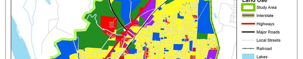

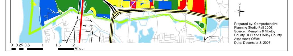
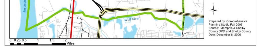
7 Map 6. Land Use


8 Map 7. Year Built
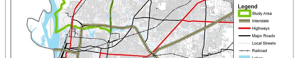
9 Map 8. Visual Survey 1 Routes Frayser Community Visual Survey 1 Areas Group 1 Priority Miles Group 1 Priority 2 Group 1 Priority 3 Group 1 Priority 4 Group 2 Priority 1 Group 2 Priority 2 Group 2 Priority 3 Group 2 Priority 4 Group 3 Priority 1 Group 3 Priority 2 Group 3 Priority 3 Group 3 Priority 4 Group 3 Priority 5 Group 4 Priority 1 Railroad Study Area Water Polygons Parks Prepared by: Comprehensive Planning Studio Fall 2006 Source: Memphis & Shelby County DPD and Shelby County Assessor's Office Date: November 1, 2006

10 Map 9. Visual Survey 1 Traffic Signs
11 Map 10. Visual Survey 1 Street Structural Condition
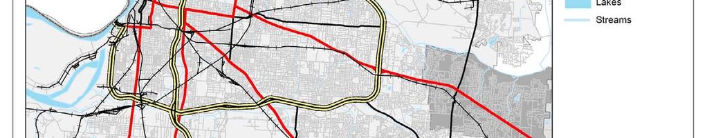
12 Map 11. Visual Survey 1 Street Width Frayser Community Visual Survey 1 Areas Street Coding ST_STWIDTH Drastic Change in Width/Lanes Uncomfortably Narrow Uncomfortably Wide Comfortable Width Interstate Highways Major Roads Local Streets Railroad Study Area Water Polygons Parks Miles Prepared by: Comprehensive Planning Studio Fall 2006 Source: Memphis & Shelby County DPD and Shelby County Assessor's Office Date: November 1, 2006
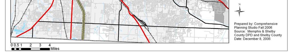
13 Map 12. Visual Survey 1 Presence of Sidewalks Frayser Community Visual Survey 1 Areas Street Coding SW_COND No Sidewalk Portion of a Sidewalk Sidewalk on One Side Sidewalk on Both Sides Interstate Highways Major Roads Local Streets Railroad Study Area Water Polygons Parks Miles Prepared by: Comprehensive Planning Studio Fall 2006 Source: Memphis & Shelby County DPD and Shelby County Assessor's Office Date: November 1, 2006

14 Map 13. Visual Survey 1 Street Score
15 Map 14. Visual Survey 2 Districts
16 Map 15. Land Use Surveyed Map 16. Frayser Structural Conditions
17
18 Map 17. Frayser Lot Conditions

19 Map18. Frayser Sidewalk Conditions
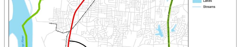
20 Map19. Accessibility to Businesses Frayser Community Retail Distances Street Railroad Commercial Areas Quarter Mile Distance Half Mile Distance Study Area Miles Prepared by: Comprehensive Planning Studio Fall 2006 Source: Memphis & Shelby County DPD and Shelby County Assessor's Office Date: November 1, 2006
21 Map 20. Accessibility to Elementary Schools Frayser Elementary School Accessibility Hawkins Mill City Elementary Schools # Entrances Within 1/4 Mile Georgian Hills Promise Academy Corning Brookmeade Within 1/2 Mile Elementary School Zones MLGW Streets Study Area Interstate Westside Whitney Frayser Denver Grandview Heights Lucie B. Campbell Highways Major Roads Local Streets Railroad Rivers, Lakes, and Streams Delano Elementary School Miles Prepared by: Comprehensive Planning Studio Fall 2006 Source: Memphis & Shelby County DPD and Shelby County Assessor's Office Date: November 1, 2006
22 Map 21. Accessibility to Middle Schools Frayser Middle School Accessibility Middle School Zones City Middle Schools # School Entrances Georgian Hills Within 1/4 Mile Within 1/2 Mile Interstate Highways Westside Frayser Memphis Business Academy Trezevant Major Roads Local Streets Railroad Rivers, Lakes, and Streams Study Area Miles Prepared by: Comprehensive Planning Studio Fall 2006 Source: Memphis & Shelby County DPD and Shelby County Assessor's Office Date: November 1, 2006
23 Map 22. Accessibility to High Schools Frayser High School Accessibility High School Zones City High Schools # High School Entrances Within 1/2 Mile Within 1/4 Mile Interstate Highways Westside Frayser Trezevant Trezevant Career & Tech Major Roads Local Streets Railroad Rivers, Lakes, and Streams Study Area Miles Prepared by: Comprehensive Planning Studio Fall 2006 Source: Memphis & Shelby County DPD and Shelby County Assessor's Office Date: November 1, 2006
24 Map 23. Accessibility to MATA Buses Frayser Accessibility to Bus System p Scheduled Bus Stop.25 Mile of Scheduled Stop.5 Mile of Scheduled Stop Mata Bus Lines Frayser/Germantown Raleigh/Bartlett Local Thomas/Hodge Watkins/Lamar.5 Mile of Bus Route.25 Mile of Bus Route Streets Railroad Study Area Rivers, Lakes, and Streams Miles Prepared by: Comprehensive Planning Studio Fall 2006 Source: Memphis & Shelby County DPD and Shelby County Assessor's Office Date: November 1, 2006

25 Map 24. Accessibility to Library
presents challenges related to utility infrastructure planning. Many of these challenges
 1 Introduction: - a. Purpose According to U.S. Census Bureau the population of stark county was 367,585 in 1990, and in 2000 it was increase to 378,098. Thus County is experiencing a growth that presents
APPENDIX I - AREA PLANS
 ROUTE 37 WEST LAND USE PLAN ROUTE 37 WEST LAND USE PLAN Recent land use decisions and development trends have drawn attention to the land within the Route 37 western by-pass area between Route 50 and
River Realty Services Commercial
 1 4 6 N O R T H U S 9 W, C O N G E R S, N Y 1 0 9 2 0 TA B L E O F C O N T E N T S E X E C U T I V E S U M M A RY 03 Z O N I N G 09 R EG I S T R AT I O N S 04 S U B J EC T P H OTO S 10 M A P V I E W 05
MAPS AND THEIR CLASSIFICATION
 MAPPING MAPS AND THEIR CLASSIFICATION WHAT IS A MAP? A map is representation of the Earth's surface, showing how things are related to each other by distance, direction, and size. Maps are a way of showing
Inclement Weather Procedures November 2, 2016
 Inclement Weather Procedures November 2, 2016 Director of Operations Mr. Sidney Pinder Jr. Purpose To explain the process of how determines when to implement the following due to inclement weather: 90-Minute
APPENDIX I: Traffic Forecasting Model and Assumptions
 APPENDIX I: Traffic Forecasting Model and Assumptions Appendix I reports on the assumptions and traffic model specifications that were developed to support the Reaffirmation of the 2040 Long Range Plan.
CITY OF ORILLIA POLICY MANUAL. Winter Operations. Table of Contents. WINTER CONTROL Objectives 2. WINTER CONTROL Season 3
 Page 1 of 12 Winter Operations Table of Contents WINTER CONTROL Objectives 2 WINTER CONTROL Season 3 SNOW ACCUMULATION Road Plowing 4,5 ICY ROADWAYS Application of Deicers/Abrasives 6 SNOW ACCUMULATION
A More Comprehensive Vulnerability Assessment: Flood Damage in Virginia Beach
 A More Comprehensive Vulnerability Assessment: Flood Damage in Virginia Beach By Raj Shah GIS in Water Resources Fall 2017 Introduction One of the most obvious effects of flooding events is death. Humans
1. Major streets, Central Business District (CBD) and school bus routes. 2. Local streets 3. Downtown parking lots
 and school bus routes. 2. Local streets 3. Downtown parking lots") City of Mt. Pleasant Administrative Memo #1-85 Issued: January 1, 1985 SUBJECT: Snow and Ice Control Policy SUMMARY: The intent of this policy is to construct a basic guideline to effectively and efficiently
City of Mt. Pleasant Administrative Memo #1-85 Issued: January 1, 1985 SUBJECT: Snow and Ice Control Policy SUMMARY: The intent of this policy is to construct a basic guideline to effectively and efficiently
NCTCOG GIS File Locations
 Boundaries Area Codes k:\bnd\region\area_codes.shp Area Type k:\bnd\region\areatype.shp Ciry Centroids (World) k:\bnd\usa_world\cities.shp City Centroids (NCTCOG Region) k:\bnd\region\city_point.shp vector.vector.bnd_city_point
California Urban Infill Trip Generation Study. Jim Daisa, P.E.
 California Urban Infill Trip Generation Study Jim Daisa, P.E. What We Did in the Study Develop trip generation rates for land uses in urban areas of California Establish a California urban land use trip
Spatial Analysis using Vector GIS THE GOAL: PREPARATION:
 PLAN 512 GIS FOR PLANNERS Department of Urban and Environmental Planning University of Virginia Fall 2006 Prof. David L. Phillips Spatial Analysis using Vector GIS THE GOAL: This tutorial explores some
CLEARING THE WAY CAUTION. brampton.ca/snow
 CLEARING THE WAY CAUTION brampton.ca/snow Who clears the roads? Not all roads in Brampton are the responsibility of the City of Brampton. The Region of Peel does winter maintenance on the major roads highlighted
EIGHT POINTS RETAIL DEVELOPMENT
 EIGHT POINTS RETAIL DEVELOPMENT FOR LEASE NEC HWY 67 & OAK GROVE RD NEW RETAIL DEVELOPMENT ANCHORED BY MENARDS AND WALMART NEIGHBORHOOD MARKET IN THE HEART OF POPLAR BLUFF RETAIL CORRIDOR. MARKET OVERVIEW
City of Laramie, Wyoming SNOW AND ICE POLICY
 City of Laramie, Wyoming SNOW AND ICE POLICY 11/02/89; rev 10/15/2007 I. INTRODUCTION The intention of this Policy is to set reasonable goals and general practices as a guide for the conduct of snow and
High Speed / Commuter Rail Suitability Analysis For Central And Southern Arizona
 High Speed / Commuter Rail Suitability Analysis For Central And Southern Arizona Item Type Reports (Electronic) Authors Deveney, Matthew R. Publisher The University of Arizona. Rights Copyright is held
Sacred Lands File & Native American Contacts List Request
 Sacred Lands File & Native American Contacts List Request NATIVE AMERICAN HERITAGE COMMISSION 915 Capitol Mall, RM 364 Sacramento, CA 95814 (916) 653-4082 (916) 657-5390 Fax nahc@pacbell.net Information
How GIS Can Help With Tribal Safety Planning
 How GIS Can Help With Tribal Safety Planning Thomas A. Horan, PhD Brian Hilton, PhD Arman Majidi, MAIS Center for Information Systems and Technology Claremont Graduate University Goals & Objectives This
Crow River Plaza - Retail Development South Diamond Lake Rd. Rogers, MN FOR LEASE 1,024 SF Retail Space. Lease Rate: $16.
 FEATURES: - Available in Rogers, MN Lease Rate: $16.00 / psf NNN - Excellent location with freeway signage on I-94! - Near large retailers such as Target, Kohls, & Applebees. Taxes $3.65 / psf Cam $3.20
PW 001 SNOW REMOVAL AND SANDING FOR ROADWAYS AND SIDEWALKS October 6, 2014 (#223-14) Original October 19, 2015; October 15, 2018 Public Works
 Original October 19, 2015; October 15, 2018 Public Works") Policy Statement: The Village of Kitscoty will provide snow and ice control on municipal streets and sidewalks according to determined priorities. Purpose: To provide direction and information to employees
Policy Statement: The Village of Kitscoty will provide snow and ice control on municipal streets and sidewalks according to determined priorities. Purpose: To provide direction and information to employees
Crow River Plaza - Retail Development South Diamond Lake Rd. Rogers, MN FOR LEASE 2,066 SF Retail Space. Lease Rate: $16.
 FEATURES: - 2,066 SF End Cap Retail Space Available in Rogers, MN - Excellent location with freeway signage on I-94! - Near large retailers such as Target, Kohls, & Applebees. - Convenient location off
SNOW CONTROL OPERATIONS 2017 PUBLIC SERVICES DEPARTMENT MAINTENANCE DIVISION
 SNOW CONTROL OPERATIONS 2017 PUBLIC SERVICES DEPARTMENT MAINTENANCE DIVISION 1 SNOW CONTROL OPERATIONS The following are the standard operating procedures f snow removal operations. 1. Plowing operations
Town of Windsor. Department of Public Works
 Town of Windsor Department of Public Works 860.285.1855 TOWN OF WINDSOR PUBLIC WORKS SNOW REMOVAL PLAN In Windsor, as throughout the New England states, winter can bring a variety of weather conditions
Septem ber 28, 2016 EL PASO, Texas
 September 28, 2016 EL PASO, Texas Crews from Paso del Norte Trackworks will finalize underground utility work and begin laying rail on a portion of Kansas Street thru Downtown El Paso in the coming weeks,
3.0 ANALYSIS OF FUTURE TRANSPORTATION NEEDS
 3.0 ANALYSIS OF FUTURE TRANSPORTATION NEEDS In order to better determine future roadway expansion and connectivity needs, future population growth and land development patterns were analyzed as part of
Applications of Map Book Software for Local Government Agencies. Melisa Bowman Lincoln Parish GIS
 Applications of Map Book Software for Local Government Agencies Melisa Bowman Lincoln Parish GIS North Central Louisiana Parish 472 Square Miles Population: 42,000 Ruston: Largest Municipality Home to
Module 3 Educator s Guide Overview
 Module 3 Educator s Guide Overview Human footprints on Earth as seen by NASA scientists Module Overview This module draws upon NASA images and research to introduce students to the various ways humans
Local Flood Hazards. Click here for Real-time River Information
 Local Flood Hazards Floods of the White River and Killbuck Creek are caused by runoff from general, and/or intense rainfall. Other areas of flooding concern are from the Boland Ditch and Pittsford Ditch.
Engineer's Report. Main Street Business Area. Festoon Lighting and Sidewalk Cleaning Assessment District (Fiscal Year )
") Engineer's Report for the Main Street Business Area Festoon Lighting and Sidewalk Cleaning Assessment District (Fiscal Year 2008-09) Prepared under the provisions of the Benefit Assessment Act of 1982
Engineer's Report for the Main Street Business Area Festoon Lighting and Sidewalk Cleaning Assessment District (Fiscal Year 2008-09) Prepared under the provisions of the Benefit Assessment Act of 1982
Remote Sensing the Urban Landscape
 Remote Sensing the Urban Landscape Urban landscape are composed of a diverse assemblage of materials (concrete, asphalt, metal, plastic, shingles, glass, water, grass, shrubbery, trees, and soil) arranged
East Bay BRT. Planning for Bus Rapid Transit
 East Bay BRT Planning for Bus Rapid Transit Regional Vision Draper Prison The Bottleneck is a State-Level issue, Salt Lake County 2050 Population: 1.5M Draper Prison hopefully with some State-Level funding!
Flood Scenario Worksheet
 Flood Scenario Worksheet Scenario adapted from: http://www.epa.gov/watersecurity/tools/trainingcd/simple/source/scenario-8/ssc8-0.pdf Simple Tabletop Exercise, Interdependency Natural Disaster Scenario,
CITY OF NEW LONDON WINTER ROAD & SIDEWALK MAINTENANCE POLICY
 CITY OF NEW LONDON WINTER ROAD & SIDEWALK MAINTENANCE POLICY GENERAL The purpose of this policy is to set up acceptable procedures and policies for the winter maintenance of public areas in the City of
INDIANAMAP VIEWING APPLICATION
 INDIANAMAP VIEWING APPLICATION (VERSION 1.0 ) Based on the 2005 Developed for the Indiana Department of Homeland Security by: IndianaMap Viewing Application Introduction The IndianaMap Viewing Application
III. FORECASTED GROWTH
 III. FORECASTED GROWTH In order to properly identify potential improvement projects that will be required for the transportation system in Milliken, it is important to first understand the nature and volume
Census and USGS: Bringing Improved TIGER to The National Map. Jennie Karalewich-Census Andrea Johnson- Census Dick Vraga- USGS
 Census and USGS: Bringing Improved TIGER to The National Map Jennie Karalewich-Census Andrea Johnson- Census Dick Vraga- USGS USGS and the Census Bureau Since 1880 there has been a close working relationship
Maricopa County Department of Transportation (MCDOT) GIS Innovations in Transportation Asset Management
 GIS Innovations in Transportation Asset Management") Maricopa County Department of Transportation (MCDOT) GIS Innovations in Transportation Asset Management Presented By Steve Hossack, GIS Database Administrator 2018 ITE/IMSA Spring Conference Maricopa County
Maricopa County Department of Transportation (MCDOT) GIS Innovations in Transportation Asset Management Presented By Steve Hossack, GIS Database Administrator 2018 ITE/IMSA Spring Conference Maricopa County
BENBROOK ECONOMIC DEVELOPMENT CORPORATION COME GROW WITH US.
 BENBROOK ECONOMIC DEVELOPMENT CORPORATION COME GROW WITH US www.benbrook-tx.gov Introduction: Who Are We Video included 04 Benbrook Demographics Click for larger image of aerial 05 Retail Opportunites
of the street when facing south and all even numbers south of Railroad Avenue shall be on the righthand side of the street when facing south.
 Page 312 of the street when facing south and all even numbers south of Railroad Avenue shall be on the righthand side of the street when facing south. (Code 1980, 26-133; Code 2003, 22-267) Secs. 46-310
City of Saginaw Right of Way Division Snow and Ice Removal Policy January 18, 2016
 Snow and Ice Removal Policy January 18, 2016 It is the policy of the to provide snowplowing and ice removal services in order to: Provide safe traveling conditions for motorists and pedestrians Assist
Louisiana Transportation Engineering Conference. Monday, February 12, 2007
 Louisiana Transportation Engineering Conference Monday, February 12, 2007 Agenda Project Background Goal of EIS Why Use GIS? What is GIS? How used on this Project Other site selection tools I-69 Corridor
GIS Needs Assessment. for. The City of East Lansing
 GIS Needs Assessment for The City of East Lansing Prepared by: Jessica Moy and Richard Groop Center for Remote Sensing and GIS, Michigan State University February 24, 2000 Executive Summary At the request
BROOKINGS May
 Appendix 1. Technical Methodology This study combines detailed data on transit systems, demographics, and employment to determine the accessibility of jobs via transit within and across the country s 100
About places and/or important events Landmarks Maps How the land is, hills or flat or mountain range Connected to maps World Different countries
 What do you think you know about geography? About places and/or important events Landmarks Maps How the land is, hills or flat or mountain range Connected to maps World Different countries What do you
COUNCIL POLICY MANUAL
 COUNCIL POLICY MANUAL SECTION: PUBLIC WORKS SUBJECT: SNOW & ICE CONTROL POLICY 2012/2013 GOAL: Pages: 1 of 10 Approval Date: Dec. 3, 2012 Res. # 1001/2012 To annually identify the winter maintenance costs
I-10 East at Redd closes for 24 hours this Sunday, Feb 11. Then, I-10 West at Resler closes for 27 hours on Feb 25
 NEWS RELEASE a TxDOT Project For immediate release EL PASO DISTRICT Jennifer Wright (915) 790-4340 Jennifer.Wright3@txdot.gov February 9, 2018 I-10 East at Redd closes for 24 hours this Sunday, Feb 11
GIS ANALYSIS METHODOLOGY
 GIS ANALYSIS METHODOLOGY No longer the exclusive domain of cartographers, computer-assisted drawing technicians, mainframes, and workstations, geographic information system (GIS) mapping has migrated to
CityGML and the Streets of New York A Proposal for Detailed Street Space Modeling
 LEONHARD OBERMEYER CENTER TUM CENTER OF DIGITAL METHODS FOR THE BUILT ENVIRONMENT CityGML and the Streets of New York A Proposal for Detailed Street Space Modeling Christof Beil & Thomas H. Kolbe Chair
Town of Bowden Province of Alberta Policy Document ( ) SNOW REMOVAL POLICY
 SNOW REMOVAL POLICY") Town of Bowden Box 338, 2101 20 th Ave Bowden, Alberta, T0M 0K0 Town of Bowden Province of Alberta Policy Document (2019-01) SNOW REMOVAL POLICY 1 INTRODUCTION The purpose of this policy is to establish
Town of Bowden Box 338, 2101 20 th Ave Bowden, Alberta, T0M 0K0 Town of Bowden Province of Alberta Policy Document (2019-01) SNOW REMOVAL POLICY 1 INTRODUCTION The purpose of this policy is to establish
The Use of Geographic Information Systems (GIS) by Local Governments. Giving municipal decision-makers the power to make better decisions
 by Local Governments. Giving municipal decision-makers the power to make better decisions") The Use of Geographic Information Systems (GIS) by Local Governments Giving municipal decision-makers the power to make better decisions Case Study: Examples of GIS Usage by Local Governments in North
The Use of Geographic Information Systems (GIS) by Local Governments Giving municipal decision-makers the power to make better decisions Case Study: Examples of GIS Usage by Local Governments in North
Brian J. Morton Center for Urban and Regional Studies University of North Carolina - Chapel Hill June 8, 2010
 Brian J. Morton Center for Urban and Regional Studies University of North Carolina - Chapel Hill June 8, 2010 1. TRANUS Highway vehicle technology Trips Mode choice Link-level traffic volumes and average
ATTACHMENT A. Item #1 Minimum Bid: $3, Parcel No Assessed Value: $10,000 Acreage: 0
 ATTACHMENT A Item #1 Minimum Bid: $3,634.59 Parcel No. 0610540500 Assessed Value: $10,000 Acreage: 0 Lots 5 and 6, Block 54, Town of Coulee Dam, Washington, according to the Second Revised Okanogan County
Xiaoguang Wang, Assistant Professor, Department of Geography, Central Michigan University Chao Liu,
 Xiaoguang Wang, Email: wang9x@cmich.edu Assistant Professor, Department of Geography, Central Michigan University Chao Liu, Email: cliu8@umd.edu Research Associate, National Center for Smart Growth, Research
SNOW CONTROL OPERATIONS
 SNOW CONTROL OPERATIONS PUBLIC WORKS TEAM STREET MAINTENANCE DIVISION SNOW CONTROL OPERATIONS Standard Operating Procedures for Snow Removal Operations. 1. Plowing operations will be initiated when snow
Texas Land Survey Maps For Wise County By Gregory A. Boyd READ ONLINE
 Texas Land Survey Maps For Wise County By Gregory A. Boyd READ ONLINE Jul 06, 2015 Genealogy Family Maps Cemetery Wise County Texas Land Survey in Books, Magazines, Texas Land Survey Maps for Wise County
Transforming the Maricopa County Department of Transportation (MCDOT) GIS-based Transportation Asset Inventory System June 30, 2016
 GIS-based Transportation Asset Inventory System June 30, 2016") Transforming the Maricopa County Department of Transportation (MCDOT) GIS-based Transportation Asset Inventory System June 30, 2016 Presented By Steve Hossack, GIS Database Administrator 2016 Esri User
Transforming the Maricopa County Department of Transportation (MCDOT) GIS-based Transportation Asset Inventory System June 30, 2016 Presented By Steve Hossack, GIS Database Administrator 2016 Esri User
Updating the Urban Boundary and Functional Classification of New Jersey Roadways using 2010 Census data
 Updating the Urban Boundary and Functional Classification of New Jersey Roadways using 2010 Census data By: Glenn Locke, GISP, PMP 1 GIS-T May, 2013 Presentation Overview Purpose of Project Methodology
Analysis of Change in Land Use around Future Core Transit Corridors: Austin, TX, Eric Porter May 3, 2012
 Analysis of Change in Land Use around Future Core Transit Corridors: Austin, TX, 1990-2006 PROBLEM DEFINITION Eric Porter May 3, 2012 This study examines the change in land use from 1990 to 2006 in the
CONGLETON INDUSTRIAL PARK LT 6 EX W 300' & E 350' LT 7 BLK 1, a subdivision of land in the City of Overland Park, Johnson County, Kansas.
 NOTICE OF PUBLIC HEARING CITY PLANNING COMMISSION CITY OF OVERLAND PARK, KANSAS Notice is hereby given that the City Planning Commission of Overland Park, Kansas, will hold a public hearing Monday, July
Technical Memorandum #2 Future Conditions
 Technical Memorandum #2 Future Conditions To: Dan Farnsworth Transportation Planner Fargo-Moorhead Metro Council of Governments From: Rick Gunderson, PE Josh Hinds PE, PTOE Houston Engineering, Inc. Subject:
Committee Meeting November 6, 2018
 Committee Meeting November 6, 2018 Agenda Where we are in the process Land Use Plan Transportation Element Housing & Neighborhoods Elements Next Steps Schedule November 6: Plan Elements December: Plan
Market Street PDP. Nassau County, Florida. Transportation Impact Analysis. VHB/Vanasse Hangen Brustlin, Inc. Nassau County Growth Management
 Transportation Impact Analysis Market Street PDP Nassau County, Florida Submitted to Nassau County Growth Management Prepared for TerraPointe Services, Inc. Prepared by VHB/Vanasse Hangen Brustlin, Inc.
Tahlequah Public Schools Inclement Weather Transportation Plan
 Tahlequah Public Schools Inclement Weather Transportation Plan Inclement Weather with Ice and Snow From time to time throughout the school year, weather may force a change in the District s normal operating
Geodatabase for Sustainable Urban Development. Presented By Rhonda Maronn Maurice Johns Daniel Ashney Jack Anliker
 Geodatabase for Sustainable Urban Development Presented By Rhonda Maronn Maurice Johns Daniel Ashney Jack Anliker Objective Build a Geodatabase that will enable urban planners to create and assess the
Dunn County Snow Removal Policy
 Dunn County Snow Removal Policy OVERVIEW With the advent of another winter season in the northern plains comes the possibility of snow, freezing rain and slippery roadways, and area resident s concern
SNOW REMOVAL GUIDE. City Of Orange Township. Public Works Snow Removal Hotline: (973) My Orange Hotline: (973)
 My Orange Hotline: (973)") Mayor Dwayne D. Warren, Esq. And The Orange Municipal Council MOVING ORANGE FORWARD City Of Orange Township SNOW REMOVAL GUIDE Public Works Snow Removal Hotline: (973) 266-4030 My Orange Hotline: (973)
Mayor Dwayne D. Warren, Esq. And The Orange Municipal Council MOVING ORANGE FORWARD City Of Orange Township SNOW REMOVAL GUIDE Public Works Snow Removal Hotline: (973) 266-4030 My Orange Hotline: (973)
King City URA 6D Concept Plan
 King City URA 6D Concept Plan King City s Evolution Among the fastest growing cities 2000 Census 1,949 2010 Census 3,111 60% increase 2016 Census estimate 3,817 23% increase Average annual rate 4.3% Surpassing
Policy Title: Snow Removal & Ice Control Policy #: PW
 Village of Fruitvale Corporate Policy Manual Policy Title: Snow Removal & Ice Control Policy #: PW-2012-01 Section: PUBLIC WORKS Initially Approved: 2012 06 04 Last Reviewed: 2013 05 06 Council Approval:
[LLAZC X.L EA0000; AZ SRP ] Notice of Temporary Closures: Selected Public Lands in La Paz County, AZ
![[LLAZC X.L EA0000; AZ SRP ] Notice of Temporary Closures: Selected Public Lands in La Paz County, AZ](/thumbs/89/100188672.jpg "[LLAZC X.L EA0000; AZ SRP ] Notice of Temporary Closures: Selected Public Lands in La Paz County, AZ") This document is scheduled to be published in the Federal Register on 12/29/2017 and available online at https://federalregister.gov/d/2017-28217, and on FDsys.gov 4310-32 DEPARTMENT OF THE INTERIOR Bureau
This document is scheduled to be published in the Federal Register on 12/29/2017 and available online at https://federalregister.gov/d/2017-28217, and on FDsys.gov 4310-32 DEPARTMENT OF THE INTERIOR Bureau
Application of high-resolution (10 m) DEM on Flood Disaster in 3D-GIS
 DEM on Flood Disaster in 3D-GIS") Risk Analysis V: Simulation and Hazard Mitigation 263 Application of high-resolution (10 m) DEM on Flood Disaster in 3D-GIS M. Mori Department of Information and Computer Science, Kinki University, Japan
Risk Analysis V: Simulation and Hazard Mitigation 263 Application of high-resolution (10 m) DEM on Flood Disaster in 3D-GIS M. Mori Department of Information and Computer Science, Kinki University, Japan
FINAL YEAR PRESENTATION USE OF GEOSPATIAL TECHNOLOGY IN SUITABILITY ANALYSIS FOR NEW SITES OF MULTI-LEVEL CAR PARKING AREAS
 FINAL YEAR PRESENTATION USE OF GEOSPATIAL TECHNOLOGY IN SUITABILITY ANALYSIS FOR NEW SITES OF MULTI-LEVEL CAR PARKING AREAS PRESENTED BY JASPHER OTIENO SUPERVISOR DR.NYIKA Contents Overview Area of study
Appendixx C Travel Demand Model Development and Forecasting Lubbock Outer Route Study June 2014
 Appendix C Travel Demand Model Development and Forecasting Lubbock Outer Route Study June 2014 CONTENTS List of Figures-... 3 List of Tables... 4 Introduction... 1 Application of the Lubbock Travel Demand
City of Brainerd, Minnesota Snowplowing Policy
 City of Brainerd, Minnesota Snowplowing Policy 1. Introduction The city of Brainerd, Minnesota, finds that it is in the best interest of the residents of the city to assume basic responsibility for control
GEOGRAPHY. Maps. n2y.com. n2y Encyclopedia
 n2y Encyclopedia GEOGRAPHY n2y.com Gg Maps W E s A map is a drawing of what a place looks like from above. A map can help you find places you want to visit. There are many different kinds of maps. All
Information for File MVP RMM
 Information for File MVP-2013-03320-RMM Applicant: City of St. Cloud Corps Contact: Ryan Malterud Address: 180 Fifth Street East, Suite 700, St. Paul, MN 55101 E-Mail: Ryan.M.Malterud@usace.army.mil Phone:
Urbanization factors in the Gilleland Creek watershed, Travis County, Texas. Michael Kanarek GEO386G Final Project Dec. 2, 2011
 Urbanization factors in the Gilleland Creek watershed, Travis County, Texas Michael Kanarek GEO386G Final Project Dec. 2, 2011 1 Introduction The watershed of Gilleland Creek, which flows through eastern
Great Lakes Information Network GIS (Queryable by topic, geography, organization, and upload date 73 layers as of October, 2009)
") Google Earth Files for the Great Lakes and Beyond GLOS Mapping Workshop Alpena, Michigan November 9, 2009 David Hart GIS Specialist University of Wisconsin Sea Grant Institute GREAT LAKES Great Lakes Information
Google Earth Files for the Great Lakes and Beyond GLOS Mapping Workshop Alpena, Michigan November 9, 2009 David Hart GIS Specialist University of Wisconsin Sea Grant Institute GREAT LAKES Great Lakes Information
ZONING DISTRICT REGULATIONS. Table 4-2 Permitted Uses by Zoning Districts Use Types AG RR R-1 R-2 R-3 MH LC CC DC GC LI GI P Addl Reg
 ZONING DITRICT REGULATION Table 4-2 Permitted Uses by Zoning Districts Agricultural Uses Horticulture P P P P P P P P P 39.06.002a Crop Production P P P 39.06.002a Type I Animal Production Type II Animal
The Northwest Environmental Training Center presents:
 The Northwest Environmental Training Center presents: Introduction to ArcHydro - Managing and Mapping Hydrologic Data with ArcGIS Course I.D. GIS-405 August 26-27, 2008, 8:30 A.M. to 5:00 P.M. (2 Days)
INDOT Office of Traffic Safety
 Intro to GIS Spatial Analysis INDOT Office of Traffic Safety Intro to GIS Spatial Analysis INDOT Office of Traffic Safety Kevin Knoke Section 130 Program Manager Highway Engineer II Registered Professional
Office of Enterprise Technology
 Office of Enterprise Technology Transforming the Maricopa Department of Transportation (MCDOT) GIS-based Transportation Asset Inventory System January 21, 2016 Presented By Steve Hossack, GIS Database
International Dark Sky Park Designation Annual Report Nomination Package
 International Dark Sky Park Designation Parashant International International Night Night Sky Sky Province Province 2017 Annual Report Nomination Package April 2014 Prepared by Eathan McIntyre Physical
Urban Planning Word Search Level 1
 Urban Planning Word Search Level 1 B C P U E C O S Y S T E M P A R E U O E U R B A N P L A N N E R T N S T D H E C O U N T Y G E R E R D W R E N I C I T Y C O U N C I L A A A S U G G C I L A G P R I R
Riocan Centre Study Area Frontenac Mall Study Area Kingston Centre Study Area
 OVERVIEW the biggest challenge of the next century (Dunham Jones, 2011). New books are continually adding methods and case studies to a growing body of literature focused on tackling this massive task.
Huron Creek Watershed 2005 Land Use Map
 Huron Creek Watershed 2005 Land Use Map Created By: Linda Kersten, 12/20/06 Created For: MTU Introduction to GIS Class (FW 5550) The Huron Creek Watershed Advisory Committee Michigan Technological University,
CLAREMONT MASTER PLAN 2017: LAND USE COMMUNITY INPUT
 Planning and Development Department 14 North Street Claremont, New Hampshire 03743 Ph: (603) 542-7008 Fax: (603) 542-7033 Email: cityplanner@claremontnh.com www.claremontnh.com CLAREMONT MASTER PLAN 2017:
Neighborhood Locations and Amenities
 University of Maryland School of Architecture, Planning and Preservation Fall, 2014 Neighborhood Locations and Amenities Authors: Cole Greene Jacob Johnson Maha Tariq Under the Supervision of: Dr. Chao
Aerial Photography and Imagery Resources Guide
 Aerial Photography and Imagery Resources Guide Cheyenne and Laramie County Cooperative GIS Created and Maintained by the GIS Coordinator for the Cooperative GIS Program March 2011 CHEYENNE / LARAMIE COUNTY
Reed School/Westover Library U USE PERMIT AMENDMENT. Staff Presentation to the County Board November 17, 2018
 Reed School/Westover Library U-3175-07-1 USE PERMIT AMENDMENT Staff Presentation to the County Board November 17, 2018 Site Location 2 Background 1644 N. McKinley Road 1938: Walter Reed Elementary School
Transit Time Shed Analyzing Accessibility to Employment and Services
 Transit Time Shed Analyzing Accessibility to Employment and Services presented by Ammar Naji, Liz Thompson and Abdulnaser Arafat Shimberg Center for Housing Studies at the University of Florida www.shimberg.ufl.edu
Aerial Photography and Imagery Resources Guide
 Aerial Photography and Imagery Resources Guide Cheyenne and Laramie County Cooperative GIS Created and Maintained by the GIS Coordinator for the Cooperative GIS Program May 2016 CHEYENNE / LARAMIE COUNTY
URISA Exemplary Systems In Government (ESIG) Award Application
 Award Application") URISA Exemplary Systems In Government (ESIG) Award Application The Urban and Regional Information Systems Association (URISA) Exemplary Systems In Government (ESIG) Awards recognize exceptional achievements
URISA Exemplary Systems In Government (ESIG) Award Application The Urban and Regional Information Systems Association (URISA) Exemplary Systems In Government (ESIG) Awards recognize exceptional achievements
CITY OF HESPERIA GENERAL PLAN UPDATE
 LAND USE TECHNICAL REPORT CITY OF HESPERIA GENERAL PLAN UPDATE September 2009 Prepared for: City of Hesperia 9700 Seventh Avenue Hesperia, CA 92345 Prepared by: Hogle-Ireland, Inc. 1500 Iowa Avenue, Suite
Area Classification of Surrounding Parking Facility Based on Land Use Functionality
 Open Journal of Applied Sciences, 0,, 80-85 Published Online July 0 in SciRes. http://www.scirp.org/journal/ojapps http://dx.doi.org/0.4/ojapps.0.709 Area Classification of Surrounding Parking Facility
City of Pittsfield. Snow and Ice Control Plan
 City of Pittsfield Snow and Ice Control Plan Overall Program The City of Pittsfield encompasses 42.5 square miles and has a population of approximately 45,000 people. The City is responsible for snow and
HIGHWAY DEPARTMENT POLICIES Center Harbor, New Hampshire
 HIGHWAY DEPARTMENT POLICIES Center Harbor, New Hampshire No: 2007-01 Date: August 22, 2007 Policy: Snow Removal and Ice Control Governing Laws: RSA 231:92-a, RSA 507-B: 2-b, Approval Date: August 22, 2007
City of Camrose Winter Road Maintenance Policy
 City of Camrose Winter Road Maintenance Policy The purpose of this policy is to outline the level of service that the City of Camrose delivers regarding the maintenance of roads in winter conditions. 1.
Oklahoma GIS for GeoCIP
 GeoCIP Program Partners Oklahoma GIS for GeoCIP A Center for Spatial Analysis Report to Oklahoma GI Council 6 November 2009 The CSA team Kathy Hines Tran Trung Semiha Caliskan Peter Camili Scott March
City of Hailey Public Works - Street Division
 City of Hailey Public Works - Street Division Snow Removal Policy 2015-2016 PRESEASON The Public Works Department s primary objective during the winter storm season is to provide safe transportation, emergency
Sensitivity of estimates of travel distance and travel time to street network data quality
 Sensitivity of estimates of travel distance and travel time to street network data quality Paul Zandbergen Department of Geography University of New Mexico Outline Street network quality Approaches to