Innovative Technologies and Methodologies to Help Solve Complex Problems in Spatial River Studies
|
|
|
- Hillary Oliver
- 5 years ago
- Views:
Transcription

1 Innovative Technologies and Methodologies to Help Solve Complex Problems in Spatial River Studies John V. Sloat Chief Technical officer WaterCube, LLC
2 Overview Water depth, water-velocity, and water-surface slope are fundamental to understanding the dynamics a river system. Advances in instrumentation, spatial data collection strategies, and processing/visualization techniques have improved significantly in recent years. Overall economic costs of these data have reduced significantly allowing access of results to a broader group of scientists, engineers and water-resources managers.
3 Outline The spatial river survey: Measuring depth, velocity, and watersurface slope along a river reach. Advances in sensing technology for spatial river surveys. The transect versus the go-with-the-flow data collection mentalities. Examining a complete workflow for spatial river surveys Examples of visualizing results getting the most from your data.
4 Spatial River Data Example (Velocity) 2-Kms 1-Kms 9-Kms
 2-Kms")
5 Spatial River Data Example (Depth) 2-Kms 1-Kms 9-Kms

 Water-Surface Along River")
6 Snake River below Swan Falls Dam Water-Surface Slope Using LiDAR Data Level Gauge Level Gauge Water-Surface Contour Extracted from LiDAR data (for similar flow event) Water-Surface Along River Center-Line

7 Studies Requiring River Spatial Surveys Instream Flow Studies Hydrodynamic Model Studies Hydraulic Studies Aquatic Habitat Studies Hydrologic Alteration Studies Sediment Transport Stream Restoration Studies Scour/Fill Studies Flow/Quality Monitoring Site Selection


8 Optimizing Workflow: Collect, Process, & Visualize RAPID DATA COLLECTION METHODS UTILIZING THE LATEST ACQUISITION TECHNOLOGY DATA PROCESSING LINKING MULTIPLE SPATIAL TECHNOLOGIES FOR COHERENT RESULTS DATA VISUALIZATION, HYDRAULIC COMPUTATION, AND DATA MANAGEMENT OF RESULTS
 Single Frequency")


9 Water Measurement Technology : ADCP (Depth & Velocity) Single Frequency ADCP Integrated Multi- Frequency ADCP/GPS/SBE Fast Sampling Multi- Frequency Telemetry GPS Echo Sounder Dynamic Ranging Reduced Cost Automated Operation

 Lidar is typically reflects off")


10 Remote Sensing Topo & DEM Creation Benefits Coverage areas typically much larger than river corridor. IR (Red) Lidar is typically reflects off water-surface. Certain conditions allow for watersurface contours to be mapped. IR LiDAR combined with ADCP Bathymetry produces complete DEM. Green LiDAR can be used for bathymetry. IR LiDAR combined with ADCP Bathymetry produces complete DEM.

11 Combined Bathymetric and ADCP Spatial Velocity Surveys Snake River, Idaho 2.0 Kms 1.0 Km


12 The Transect Survey Mindset While technology and processing techniques have increased significantly river data is typically limited to transect views at several locations in the river. This significantly limits our need to understand critical river dynamics.

13 Measurement Strategy Going with the Flow ADCP is navigated downstream parallel to flow. Multiple ADCPs can be used to reduce measurement time. Each boat typically will float with the river current, or move slowly downstream. Upstream transects are possible only in lower currents. In most cases, 8-12 parallel lines are needed to resolve river conditions. Cross-stream transects can be used in sections of high interest or increased complexity.

14 Vectors and Cross-Sections Velocity Vectors Throughout
15 Snake River below CJ Strike Dam- Example Line Plan with Markers ADCP Track Lines
16 Combining ADCP Bathymetry and LiDAR ADCP Bathymetry LiDAR Merged ADCP & LiDAR Full DEM

17 Velocity Contours and Layers ADCP Mapped Velocities Velocity Layers Column

18 Sub-Section Sampling and Views Sub-Cubes- Higher Precision Grid


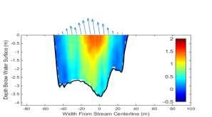
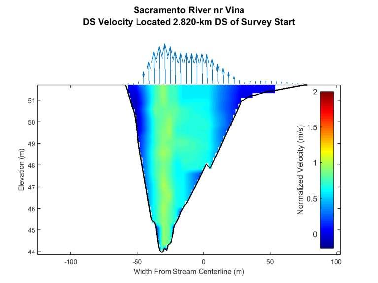
19 Sacramento River- California Capturing ADCP Track Bathymetry Lines & 5Km of Velocity River Throughout

20 Flood Measurements with Remote-Controlled Boats
21 Velocity Meter Depth Below Surface

22 Velocity Meter Depth Below Surface
23 Velocity Meter Depth Below Surface
24 Velocity Meter Depth Below Surface
25 Velocity Meter Depth Below Surface
26
27 DE
28
29
30
31
32
33
34
35
36
37
38
39
40
41
42
43
44
45
46
47
48
49
50
51
52
53
54
55
56
57
58
59
60
61
62
63
64
65
66
67
68
69
70
71
72
73
74
75
76
77
78
79
80
81
82 Conclusions Depth, Velocity, and Water-Surface Slope are critical to understanding complex river hydraulics. Many studies lack this critical data limiting their reliability. Recent advances in sensing technology and sampling methodologies are reducing costs and improving results which is increasing the amount of data available for river studies. Collection, Processing, and Visualization define the strategic workflow and must be considered to optimize results. Accurate and reliable data = Better Results = Better Decisions

83 Thank You! Mississippi River Flood, 2007
Varying Bathymetric Data Collection Methods and their Impact on Impoundment Volume and Sediment Load Calculations I.A. Kiraly 1, T.
 Varying Bathymetric Data Collection Methods and their Impact on Impoundment Volume and Sediment Load Calculations I.A. Kiraly 1, T. Sullivan 2 1 Gomez and Sullivan Engineers, D.P.C., 41 Liberty Hill Road,
Envisioning Hydrometric Data to Enhance Management of River Systems
 to Enhance Management of River Systems Scott Graduate Research Assistant, University of Illinois, Urbana, Illinois, USA E-mail: sbanjav2@illinois.edu John Sloat Chief Technical Officer, WaterCubeData,
MaxDepth Aquatics, Inc.
 MaxDepth Aquatics, Inc. Bathymetry of Mirror Pond From Newport Bridge to Galveston Bridge Prepared for the City of Bend By Joseph Eilers & Benn Eilers MaxDepth Aquatics, Inc. Bend, OR June 2005 INTRODUCTION
Bishopville Prong Study
 Bathymetric and Sediment Assessment in the Bishopville Prong of St. Martin River Darlene V. Wells, Richard A. Ortt, Jr., and Stephen Van Ryswick Funded by MCBP 2011-2012 Implementation Grant Objectives
Beaver Creek Corridor Design and Analysis. By: Alex Previte
 Beaver Creek Corridor Design and Analysis By: Alex Previte Overview Introduction Key concepts Model Development Design Accuracy Conclusion Refresh v = Beaver Creek Site = Wittenberg Introduction Low head
Channel responses to the removal of Gold Ray and Savage Rapids Dam. Prepared by Desirée Tullos and Cara Water
 Channel responses to the removal of Gold Ray and Savage Rapids Dam Prepared by Desirée Tullos and Cara Water Introduction. As the results of extensive efforts over several decades, the Rogue River is now
Hydrologic Analysis for Ecosystem Restoration
 Hydrologic Analysis for Ecosystem Restoration Davis, California Objectives: To provide participants with: 1) an understanding of the issues in restoration studies; 2) an overview of Corps policies and
St. Clair River Conveyance Change 2007 to 2012
 St. Clair River Conveyance Change 2007 to 2012 Morphologic Change in the St. Clair River 2007 2012 Conveyance Change Report U.S. Army Corps of Engineers, Detroit District Great Lakes Hydraulics and Hydrology
Tom Glass, B.S. Whitman College Sarah Wasssmund, B.S. Humboldt State University Edgar Verdin, B.S. Portland State University Kelsi Lakey, B.S.
 Tom Glass, B.S. Whitman College Sarah Wasssmund, B.S. Humboldt State University Edgar Verdin, B.S. Portland State University Kelsi Lakey, B.S. Washington State University Overview 1. Background 2. History
Menno W. Straatsma, Hans Middelkoop, Steven de Jong
 Fig. A-2.1: Field photograph of a floodplain with a side channel. After deposition, sediment-associated pollutants, such as metals, are incorporated in the ecological food-chain (Torres and Johnson, 2001).
NOAA/University of New Hampshire Joint Hydrographic Center & Center for Coastal and Ocean Mapping. MAPPS Summer Conference July 23, 2013
 NOAA/University of New Hampshire Joint Hydrographic Center & Center for Coastal and Ocean Mapping MAPPS Summer Conference July 23, 2013 07/23/2013 2 07/23/2013 3 Center Goals To be a world leader in the
Development of Riparian Maps for Sonoma County Long Term Riparian Corridor Conservation. Mark Tukman & Dylan Loudon Tukman Geospatial
 L A N D F O R Development of Riparian Maps for Sonoma County Long Term Riparian Corridor Conservation Mark Tukman & Dylan Loudon Tukman Geospatial L I F E Mark Background on functional riparian mapping
Lidar-derived Hydrography as a Source for the National Hydrography Dataset
 Lidar-derived Hydrography as a Source for the National Hydrography Dataset Lidar-Derived Hydrography, Bathymetry, and Topobathymetry in the National Hydrography Dataset and 3-Dimensional Elevation Program
Geomorphology Studies
 Geomorphology Studies Technical Workgroup Meeting February 14, 2012 Prepared by: Tetra Tech Prepared for: Alaska Energy Authority Overall Goal Geomorphology Studies Two studies Geomorphology Study (RSP
Development and application of demonstration MIKE 21C morphological model for a bend in Mekong River
 Development and application of demonstration MIKE 21C morphological model for a bend in Mekong River September 2015 0 Table of Contents 1. Introduction... 2 2. Data collection... 3 2.1 Additional data...
Background. Points of Discussion. Hydrographic Models
 Airborne Laser Remote Sensing Technology: Providing Essential Hydrologic Information in the 21 st Century Warwick Hadley, Optech Incorporated Presented by: Warwick Hadley Sales Manager, Middle East and
Mississippi River and Tributaries Project Mississippi River Geomorphology and Potamology Program
 Mississippi River and Tributaries Project Mississippi River Geomorphology and Potamology Program Barb Kleiss, Mississippi Valley Division Freddie Pinkard, Vicksburg District June, 2016 Program Objectives
UC Berkeley Technical Completion Reports
 UC Berkeley Technical Completion Reports Title Hydrodynamics of shallow water habitats in the Sacramento-San Joaquin Delta Permalink https://escholarship.org/uc/item/3j77h7t6 Author Stacey, Mark T Publication
AIM Master Sample: A Tool to Support Statistically Valid Sample Designs
 AIM Master Sample: A Tool to Support Statistically Valid Sample Designs AIM A National Strategy designed to: Promote integrated, cross-program resource inventory, assessment, and monitoring at multiple
Hydraulic Processes Analysis System (HyPAS)
") Hydraulic Processes Analysis System (HyPAS) by Thad C. Pratt and Daryl S. Cook PURPOSE: This Coastal Engineering Technical Note (CETN) describes a PC-Windows-based system for analyzing, visualizing, and
Hydraulic Processes Analysis System (HyPAS) by Thad C. Pratt and Daryl S. Cook PURPOSE: This Coastal Engineering Technical Note (CETN) describes a PC-Windows-based system for analyzing, visualizing, and
Flood River Discharge Measurement Method in Japan
 Flood River Discharge Measurement Method in Japan Hydrologic Engineering Research Team Hydraulic Engineering Research Group Public Work Research Institute (PWRI) Contents 1. Overview of River Discharge
Manitoba s Elevation (LiDAR) & Imagery Datasets. Acquisition Plans & Opportunities for Collaboration
 & Imagery Datasets. Acquisition Plans & Opportunities for Collaboration") Manitoba s Elevation (LiDAR) & Imagery Datasets Acquisition Plans & Opportunities for Collaboration Manitoba Planning Conference May 2017 Presentation Outline Manitoba s Elevation (LiDAR) and Imagery Datasets
Manitoba s Elevation (LiDAR) & Imagery Datasets Acquisition Plans & Opportunities for Collaboration Manitoba Planning Conference May 2017 Presentation Outline Manitoba s Elevation (LiDAR) and Imagery Datasets
ANALYSIS OF FLOW CONDITIONS AT THE IHNC-GIWW SECTOR GATE
 ANALYSIS OF FLOW CONDITIONS AT THE IHNC-GIWW SECTOR GATE SLFPA-E October 2016 Motivation SLFPA-E has observed high velocities within the opening of the GIWW sector gate at the surge barrier. Concern about
Bed-load measurements on large, sand-bed rivers in the United States
 Bed-load measurements on large, sand-bed rivers in the United States David Abraham 1,*, Tate McAlpin 1, and Keaton Jones 1 1 US Army Corps of Engineers, Coastal and Hydraulics Laboratory, Vicksburg MS,
ASFPM - Rapid Floodplain Mapping
 ASFPM - Nicole Cominoli Hydraulic Engineer USACE - Omaha District mary.n.cominoli@usace.army.mil June 3, 2015 US Army Corps of Engineers Mitigation = Risk Informed Decisions 2 The National Flood Insurance
A SIMPLE GIS METHOD FOR OBTAINING FLOODED AREAS
 A SIMPLE GIS METHOD FOR OBTAINING FLOODED AREAS ROMAN P., I. 1, OROS C., R. 2 ABSTRACT. A simple GIS method for obtaining flooded areas. This paper presents a method for obtaining flooded areas near to
Watershed Delineation in GIS Environment Rasheed Saleem Abed Lecturer, Remote Sensing Centre, University of Mosul, Iraq
 Watershed Delineation in GIS Environment Rasheed Saleem Abed Lecturer, Remote Sensing Centre, University of Mosul, Iraq Abstract: The management and protection of watershed areas is a major issue for human
South Florida Coastal Storm Surge and Mapping Study
 South Florida Coastal Storm Surge and Mapping Study Presented by Christopher Bender, Ph.D., P.E., D.CE June 2, 2015 Presentation Overview FEMA risk studies outline Overview South Florida surge study Work
SCOPE OF PRESENTATION STREAM DYNAMICS, CHANNEL RESTORATION PLANS, & SEDIMENT TRANSPORT ANALYSES IN RELATION TO RESTORATION PLANS
 DESIGN METHODS B: SEDIMENT TRANSPORT PROCESSES FOR STREAM RESTORATION DESIGN PETER KLINGEMAN OREGON STATE UNIVERSITY CIVIL ENGINEERING DEPT., CORVALLIS 2 ND ANNUAL NORTHWEST STREAM RESTORATION DESIGN SYMPOSIUM
WELCOME Lake Wabukayne OPEN HOUSE
 WELCOME Lake Wabukayne Sediment Removal Project OPEN HOUSE We are here to: Update you, the community, on recent developments and activities at Lake Wabukayne Present the preferred alternative and receive
USGS Hydrography Overview. May 9, 2018
 + 1 USGS Hydrography Overview May 9, 2018 + 2 The National Geospatial Program Provides the geospatial baseline of the Nation s topography, natural landscape and built environment through The National Map,
Extreme Phenomena in Dobrogea - Floods and Droughts
 Extreme Phenomena in Dobrogea - Floods and Droughts PhD eng. Carmen Maftei Ovidius University of Constanta (Partner no 4) OUTLINES Introduction Study area Drought Floods Conclusion What is the problem?
Second National Symposium on GIS in Saudi Arabia Al Khober, April 23-25, 2007
 Second National Symposium on GIS in Saudi Arabia Al Khober, April 23-25, 2007 Sherine S. Ismail Nile Research Institute, National Water Research Center, Egypt E-mail: sherine_shawky@yahoo.com Hoda F. Mohamed
Object Based Imagery Exploration with. Outline
 Object Based Imagery Exploration with Dan Craver Portland State University June 11, 2007 Outline Overview Getting Started Processing and Derivatives Object-oriented classification Literature review Demo
Remaining Capacity in Great Lakes Reservoirs
 US Army Corps of Engineers Detroit District Remaining Capacity in Great Lakes Reservoirs Storage Capacity Behind Great Lakes Dams Field Data and Modeling Motivation for project Project overview Data and
Appendix G. Meso-Habitat Surveys. DRAFT Annual Technical Report
 Appendix G Meso-Habitat Surveys DRAFT Annual Technical Report Draft March 2010 1.0 Introduction 1 2 3 4 5 6 1.0 Introduction The following appendix includes a report provided by the California Department
STREAM GAUGING TECHNIQUES
 World Meteorological Organization -- Working together in weather, climate and water STREAM GAUGING TECHNIQUES Presentation based on the WMO Manual on streamgauging (2010), Volume II Chapter 2, with additional
Habitat Monitoring Update Hudson River CAG November 16, 2017
 Habitat Monitoring Update Hudson River CAG November 16, 2017 Habitat Reconstruction Overview: Habitats A habitat replacement program is being implemented in an Adaptive Management context to reconstruct
PROPOSAL TO MAP THE LOWER YUBA RIVER CORRIDOR IN HIGH RESOLUTION TO SUPPORT RIPARIAN AND CHANNEL RESTORATION. Professor Greg Pasternack, UC Davis
 Summary PROPOSAL TO MAP THE LOWER YUBA RIVER CORRIDOR IN HIGH RESOLUTION TO SUPPORT RIPARIAN AND CHANNEL RESTORATION Professor Greg Pasternack, UC Davis In-stream and riparian assessments are underway
A Comprehensive Inventory of the Number of Modified Stream Channels in the State of Minnesota. Data, Information and Knowledge Management.
 A Comprehensive Inventory of the Number of Modified Stream Channels in the State of Minnesota Data, Information and Knowledge Management Glenn Skuta Environmental Analysis and Outcomes Division Minnesota
Efficiencies in Data Acquisition and Transformation
 Efficiencies in Data Acquisition and Transformation Andrew LEYZACK Canada Key words: Hydrography, IHO S-57, Nautical Chart SUMMARY For many hydrographic offices, the introduction of electronic nautical
Impact of DEM Resolution on Topographic Indices and Hydrological Modelling Results
 Impact of DEM Resolution on Topographic Indices and Hydrological Modelling Results J. Vaze 1, 2 and J. Teng 1, 2 1 Department of Water and Energy, NSW, Australia 2 ewater Cooperative Research Centre, Australia
Tools to Assess Flood Risk of Commercial Property Investment
 Tools to Assess Flood Risk of Commercial Property Investment NSERC Workshop March 1, 2016 Kate Collins, Tim Webster, Nathan Crowell AGRG, NSCC, Middleton, NS https://eatsleepride.com/ http://users.eastlink.ca/~tbulley/
J.B. Shaw and D. Mohrig
 GSA DATA REPOSITORY 2014008 J.B. Shaw and D. Mohrig Supplementary Material Methods Bathymetric surveys were conducted on 26 June- 4 July, 2010 (Fig. 2A), 7 March, 2011 (Fig. 2B), 11-12 August, 2011 (Figs.
UPPER COSUMNES RIVER FLOOD MAPPING
 UPPER COSUMNES RIVER FLOOD MAPPING DRAFT BASIC DATA NARRATIVE FLOOD INSURANCE STUDY SACRAMENTO COUTY, CALIFORNIA Community No. 060262 November 2008 Prepared By: CIVIL ENGINEERING SOLUTIONS, INC. 1325 Howe
PART 2:! FLUVIAL HYDRAULICS" HYDROEUROPE
 PART 2:! FLUVIAL HYDRAULICS" HYDROEUROPE 2009 1 HYDROEUROPE 2009 2 About shear stress!! Extremely complex concept, can not be measured directly!! Computation is based on very primitive hypotheses that
EMERGENCY PLANNING IN NORTHERN ALGERIA BASED ON REMOTE SENSING DATA IN RESPECT TO TSUNAMI HAZARD PREPAREDNESS
 EMERGENCY PLANNING IN NORTHERN ALGERIA BASED ON REMOTE SENSING DATA IN RESPECT TO TSUNAMI HAZARD PREPAREDNESS Barbara Theilen-Willige Technical University of Berlin, Institute of Applied Geosciences Department
URBAN WATERSHED RUNOFF MODELING USING GEOSPATIAL TECHNIQUES
 URBAN WATERSHED RUNOFF MODELING USING GEOSPATIAL TECHNIQUES DST Sponsored Research Project (NRDMS Division) By Prof. M. GOPAL NAIK Professor & Chairman, Board of Studies Email: mgnaikc@gmail.com Department
Topography and Bathymetry
 Topography and Bathymetry Overview: Students are introduced to the concepts of bathymetry and topography, and build a model to demonstrate an understanding of both. Targeted Alaska Grade Level Expectations:
GEOL- 270: Issues in Oceanography Developed by Jessica Kleiss, Lewis & Clark College
 GEOL- 270: Issues in Oceanography Developed by Jessica Kleiss, Lewis & Clark College Lab 02: Ocean floor bathymetry. Material for students to bring: A calculator A ruler Pens and pencils Objectives: Interpret
GRAPEVINE LAKE MODELING & WATERSHED CHARACTERISTICS
 GRAPEVINE LAKE MODELING & WATERSHED CHARACTERISTICS Photo Credit: Lake Grapevine Boat Ramps Nash Mock GIS in Water Resources Fall 2016 Table of Contents Figures and Tables... 2 Introduction... 3 Objectives...
Stream Restoration and Environmental River Mechanics. Objectives. Pierre Y. Julien. 1. Peligre Dam in Haiti (deforestation)
") Stream Restoration and Environmental River Mechanics Pierre Y. Julien Malaysia 2004 Objectives Brief overview of environmental river mechanics and stream restoration: 1. Typical problems in environmental
Stream Restoration and Environmental River Mechanics Pierre Y. Julien Malaysia 2004 Objectives Brief overview of environmental river mechanics and stream restoration: 1. Typical problems in environmental
Great Lakes Update. Geospatial Technologies for Great Lakes Water Management. Volume 149 October 4, US Army Corps of Engineers Detroit District
 Volume 149 October 4, 2002 US Army Corps of Engineers Detroit District Great Lakes Update Geospatial Technologies for Great Lakes Water Management The U.S. Army Corps of Engineers (USACE) serves an important
Bank Erosion and Morphology of the Kaskaskia River
 Bank Erosion and Morphology of the Kaskaskia River US Army Corps Of Engineers St. Louis District Fayette County Soil and Water Conservation District Team Partners : Carlyle Lake Ecosystem Partnership Vicinity
Bathymetric and Hydrodynamic Analysis of Wax Lake Delta
 Bathymetric and Hydrodynamic Analysis of Wax Lake Delta I. Introduction A. Motivation The ability to explain and predict how any physical system behaves is paramount in understanding how that system will
Using Morphometric models and Open Source Software to locate Flood prone areas A guide to pilot Implementation
 SciNetNatHaz Project Progress Meeting - 23-26 Oct 2014, Burgas, Bulgaria SciNetNatHaz Project Progress Meeting - 7-9 May 2015, Thessaloniki, Hellas Using Morphometric models and Open Source Software to
Implementing a vector-based river routing scheme within the WRF-Hydro modeling system
 Implementing a vector-based river routing scheme within the WRF-Hydro modeling system Peirong Lin 1, Zong-Liang Yang 1, David Gochis 2, Wei Yu 2, Cédric H. David 3, David Maidment 4 1. Jackson School of
INTERNATIONAL JOURNAL OF GEOMATICS AND GEOSCIENCES Volume 1, No 4, 2011
 Detection of seafloor channels using Bathymetry data in Geographical Information Systems Kundu.S.N, Pattnaik.D.S Department of Geology, Utkal University, Vanivihar, Bhubaneswar. Orissa. snkundu@gmail.com
Hydroacoustic survey and bathymetric map creation for Brant Lake, New York
 Hydroacoustic survey and bathymetric map creation for Brant Lake, New York Holly A. Waterfield CLM 1 INTRODUCTION Brant Lake is located in Warren County, New York, within the bounds of the Adirondack Park.
COMPARISON OF MODELS AND VOLUMETRIC DETERMINATION FOR CATUSA LAKE, GALATI
 COMPARISON OF MODELS AND VOLUMETRIC DETERMINATION FOR CATUSA LAKE, GALATI Arseni Maxim 1, Rosu Adrian 2, Nicolae Alina-Florina, Georgescu Puiu Lucian and Constantin Daniel-Eduard 1,2,,, European Center
Inspection of Waterfront Facilities Using Vessel-Based Remote Sensing Mitchell, Del Bello, Suarez
 Inspection of Waterfront Facilities Using Vessel-Based Remote Sensing Mitchell, Del Bello, Suarez American Association of Port Authorities Facilities Engineering Conference October 20-22, 2015 Waterfront
Two-Dimensional Simulation of Truckee River Hydrodynamics
 Two-Dimensional Simulation of Truckee River Hydrodynamics by Stephen H. Scott PURPOSE: The purpose of this Coastal and Hydraulics Engineering Technical Note (CHETN) is to demonstrate the use of multidimensional
Current and Future Technology Applications for Coastal Zone Management. Bruce K. Carlisle, Acting Director Office of Coastal Zone Management
 Current and Future Technology Applications for Coastal Zone Management Bruce K. Carlisle, Acting Director Office of Coastal Zone Management The Massachusetts Coastal Zone Management Program Approved in
Opportunities to Improve Ecological Functions of Floodplains and Reduce Flood Risk along Major Rivers in the Puget Sound Basin
 Opportunities to Improve Ecological Functions of Floodplains and Reduce Flood Risk along Major Rivers in the Puget Sound Basin Christopher Konrad, US Geological Survey Tim Beechie, NOAA Fisheries Managing
By Richard L. Kiesling. Open-File Report 2016-XXX
 By Richard L. Kiesling Open-File Report 216-XXX U.S. Department of the Interior SALLY JEWELL, Secretary U.S. Geological Survey Suzette M. Kimball, Director U.S. Geological Survey, Reston, Virginia: 21X
River Current Resource Assessment and Characterization Considering Ice Conditions
 River Current Resource Assessment and Characterization Considering Ice Conditions 1 Gilles Boesch, Eng, M.Eng Marie-Hélène Briand, Eng, PhD Vadim Belotserkovsky International Conference on Ocean Energy,
Hydraulic and Sediment Transport Modeling Strategy
 Appendix B Hydraulic and Sediment Transport Modeling Strategy May 2014 Technical Memorandum Channel Capacity Report January 2015 San Joaquin River Restoration Program Hydraulic and Sediment Transport Modeling
Paper 114 Validation of Actual Depth Measurements by Inland Vessels
 Paper 114 Validation of Actual Depth Measurements by Inland Vessels VAN DER MARK C.F. 1 ; VIJVERBERG T. 2 ; OTTEVANGER W. 1 1 Deltares, Delft, the Netherlands 2 Royal HaskoningDHV, Amersfoort, the Netherlands
The Arctic - A New Frontier The geological, environmental and engineering challenges for submarine telecommunication cables
 The Arctic - A New Frontier The geological, environmental and engineering challenges for submarine telecommunication cables Ryan Wopschall 5 September 2013 Oceanology International China, Shanghai Fugro
Dealing with Zone A Flood Zones. Topics of Discussion. What is a Zone A Floodplain?
 Dealing with Zone A Flood Zones Topics of Discussion Overview of Zone A Floodplains Permitting Development in Zone A Floodplains Estimating Flood Elevations in Zone A Flood Insurance Implications Letters
StreamStats: Delivering Streamflow Information to the Public. By Kernell Ries
 StreamStats: Delivering Streamflow Information to the Public By Kernell Ries U.S. Department of the Interior U.S. Geological Survey MD-DE-DC District 410-238-4317 kries@usgs.gov StreamStats Web Application
Appendix O. Sediment Transport Modelling Technical Memorandum
 Appendix O Sediment Transport Modelling Technical Memorandum w w w. b a i r d. c o m Baird o c e a n s engineering l a k e s design r i v e r s science w a t e r s h e d s construction Final Report Don
Temporal variability of partially-contaminated sediments in a strongly regulated reservoir of the upper Rhine River
 Temporal variability of partially-contaminated sediments in a strongly regulated reservoir of the upper Rhine River Germain Antoine 1,2,, Thomas Pretet 1,3,, Matthieu Secher 3,, and Anne Clutier 3, 1 Laboratoire
Humanitarian Assistance and Disaster Relief (HADR)
") Humanitarian Assistance and Disaster Relief (HADR) Remote sensing, GIS & Server Technology for Planning, Response & Mitigation Jonathan Lee Hon Yip Senior Technical Sales, Intergraph Security, Government
Humanitarian Assistance and Disaster Relief (HADR) Remote sensing, GIS & Server Technology for Planning, Response & Mitigation Jonathan Lee Hon Yip Senior Technical Sales, Intergraph Security, Government
Suspended Sediment Rating Curve for Tigris River Upstream Al- Betera Regulator
 International Journal of Research in Engineering and Science (IJRES) ISSN (Online): 2320-9364, ISSN (Print): 2320-9356 Volume 3 Issue 8 ǁ August. 2015 ǁ PP.61-65 Suspended Sediment Rating Curve for Tigris
Supplement of Scenario-based numerical modelling and the palaeo-historic record of tsunamis in Wallis and Futuna, Southwest Pacific
 Supplement of Nat. Hazards Earth Syst. Sci., 15, 1763 1784, 2015 http://www.nat-hazards-earth-syst-sci.net/15/1763/2015/ doi:10.5194/nhess-15-1763-2015-supplement Author(s) 2015. CC Attribution 3.0 License.
!"#$%&&'()*+#$%(,-./0*)%(!
*+#$%(,-./0*)%(!") 8:30 Sign in Hoosic River Revival Coalition!"#$%&&'()*+#$%(,-./0*)%(! 12-#30+4/#"5-(60 9:00 Welcome and Introductions 9:15 Goals for Today s Program: A Description of the Planning Process 9:30 First Session:
8:30 Sign in Hoosic River Revival Coalition!"#$%&&'()*+#$%(,-./0*)%(! 12-#30+4/#"5-(60 9:00 Welcome and Introductions 9:15 Goals for Today s Program: A Description of the Planning Process 9:30 First Session:
MLLW and the NAD83 Ellipsoid: An Investigation of Local Offsets and Trends Using PPK and Gauge Derived Water Surfaces.
 MLLW and the NAD83 Ellipsoid: An Investigation of Local Offsets and Trends Using PPK and Gauge Derived Water Surfaces. Abstract: Authors Doug Lockhart, Fugro Pelagos, Inc. Andy Orthmann, Fugro Pelagos,
Gold Ray Dam Removal Monitoring: OSU Summary. Prepared by Desiree Tullos and Cara Walter
 Gold Ray Dam Removal Monitoring: OSU Summary Prepared by Desiree Tullos and Cara Walter December 11, 2012 Data Collection Data collection by Oregon State University consisted of three components on approximately
Strategies for managing sediment in dams. Iwona Conlan Consultant to IKMP, MRCS
 Strategies for managing sediment in dams Iwona Conlan Consultant to IKMP, MRCS 1 Sediment trapping by dams Active storage capacity Dead storage coarse material (bed load) Fine materials (suspension) Francis
USING MIKE TO MODEL COASTAL CATASTROPHE RISK
 USING MIKE TO MODEL COASTAL CATASTROPHE RISK Nicola Howe, Christopher Thomas, Joss Matthewman, John Maskell* 1 SUMMARY About RMS Who are we and what do we do? How do we use MIKE in our workflow? Case study:
Numerical Modeling Of Flow And Sediment Transport Within The Lower Reaches Of The Athabasca River: A Case Study
 City University of New York (CUNY) CUNY Academic Works International Conference on Hydroinformatics 8-1-2014 Numerical Modeling Of Flow And Sediment Transport Within The Lower Reaches Of The Athabasca
How Do Human Impacts and Geomorphological Responses Vary with Spatial Scale in the Streams and Rivers of the Illinois Basin?
 How Do Human Impacts and Geomorphological Responses Vary with Spatial Scale in the Streams and Rivers of the Illinois Basin? Bruce Rhoads Department of Geography University of Illinois at Urbana-Champaign
State Water Survey Division SURFACE WATER SECTION
 State Water Survey Division SURFACE WATER SECTION AT THE UNIVERSITY OF ILLINOIS Illinois Department of Energy and Natural Resources SWS Miscellaneous Publication 88 SEDIMENTATION OF POOL 19 ON THE MISSISSIPPI
A Detailed Examination of DTM Creation Methods and Sources. Study Area Overview
 A Detailed Examination of DTM Creation Methods and Sources Adam Mosbrucker & Melinda Lamb Geography 593: Dec. 2 nd, 2010 Study Area Overview Mt. St. Helens -active volcano many eruptions in the past 30
08/01/2012. LiDAR. LiDAR Benefits. LiDAR-BASED DELINEATION OF WETLAND BORDERS. CCFFR-2012 Society for Canadian Limnologists:
 LiDAR CCFFR-2012 Society for Canadian Limnologists: Science for Wetland Policy and Management LiDAR-BASED DELINEATION OF WETLAND BORDERS Distance from laser to ground and back again: Determined as laser-pulse
Georeferencing Water Quality Assessments to NHDPlus Catchments
 Georeferencing Water Quality Assessments to NHDPlus Catchments A New Approach to Evaluating and Measuring Progress in Surface Water Quality DWANE YOUNG, U.S. EPA, OFFICE OF WATER Outline Georeferencing
Integrated methodology for assessing the effects of geomorphological river restoration on fish habitat and riparian vegetation
 Integrated methodology for assessing the effects of geomorphological river restoration on fish habitat and riparian vegetation Judit Maroto *a, Miguel Marchamalo a,b, Diego García de Jalón a, Marta González
USING 3D GIS TO ASSESS ENVIRONMENTAL FLOOD HAZARDS IN MINA
 King Fahd University of Petroleum & Minerals College of Environmental Design Geographical Information system USING 3D GIS TO ASSESS ENVIRONMENTAL FLOOD HAZARDS IN MINA Prepared by : Ali AL-Zahrani OUTLINE
Land Administration and Cadastre
 Geomatics play a major role in hydropower, land and water resources and other infrastructure projects. Lahmeyer International s (LI) worldwide projects require a wide range of approaches to the integration
The 3D Elevation Program: Overview. Jason Stoker USGS National Geospatial Program ESRI 2015 UC
 + The 3D Elevation Program: Overview Jason Stoker USGS National Geospatial Program ESRI 2015 UC + 2 A little history USGS has a long, proud tradition of mapmaking (2009) + 3 The changing times Mapping
Flood Inundation Mapping
 KU GIS Day 2009 November 18, 2009 Flood Inundation Mapping Wendy L. Pearson NOAA s National Weather Service Central Region Headquarters Kansas City, Missouri Flood Inundation Mapping Objectives: Overview
Overview. Gulf of Mexico Alliance Ocean and Coastal Mapping Regional Ecosystem Data Management (REDM) Q2O (QARTOD to OGC) Things to Consider
 Q2O (QARTOD to OGC) Things to Consider") 1 Overview Gulf of Mexico Alliance Ocean and Coastal Mapping Regional Ecosystem Data Management (REDM) Q2O (QARTOD to OGC) Things to Consider 2 Gulf Of Mexico Alliance Partnership of the states of Alabama,
1 Overview Gulf of Mexico Alliance Ocean and Coastal Mapping Regional Ecosystem Data Management (REDM) Q2O (QARTOD to OGC) Things to Consider 2 Gulf Of Mexico Alliance Partnership of the states of Alabama,
Analysis of the Effects of Bendway Weir Construction on Channel Cross Sectional Geometry
 Mississippi River Miles 275.2 1.7 Analysis of the Effects of Bendway Weir Construction on Channel Cross Sectional Geometry By Timothy Lauth David Gordon, P.E. Katherine Clancey Adam Rockwell Brad Krischel
What s New in Topographic Information - USGS National Map
 + What s New in Topographic Information - USGS National Map SARGIS Workshop November 14, 2016 Rob Dollison, 703-648-5724 rdollison@usgs.gov + USGS 2 National Geospatial Program The National Geospatial
Hydrologic Engineering Applications of Geographic Information Systems
 Hydrologic Engineering Applications of Geographic Information Systems Davis, California Objectives: The participant will acquire practical knowledge and skills in the application of GIS technologies for
GIS and Remote Sensing
 Spring School Land use and the vulnerability of socio-ecosystems to climate change: remote sensing and modelling techniques GIS and Remote Sensing Katerina Tzavella Project Researcher PhD candidate Technology
Computational Modeling of River Flow, Sediment Transport, and Bed Evolution Using Remotely Sensed Data
 DISTRIBUTION STATEMENT A: Approved for public release; distribution is unlimited. Computational Modeling of River Flow, Sediment Transport, and Bed Evolution Using Remotely Sensed Data Jonathan M. Nelson
Sediment Resuspension by Dredges: Defining the Issues
 Sediment Resuspension by Dredges: Defining the Issues Doug Clarke Environmental Laboratory U.S. Army Corps of Engineers Engineer Research and Development Center Dredge types Definition Related processes
Birch Creek Geomorphic Assessment and Action Plan
 Birch Creek Geomorphic Assessment and Action Plan Jim Webster Tim Hanrahan, PhD, CFM Jesse Schwartz, PhD Zach Hill January 22, 2015 White Eagle Grange This Project is a First Step in Strategy Planning