Vít PÁSZTO Karel MACKŮ
|
|
|
- Lenard Phillips
- 5 years ago
- Views:
Transcription
1 What is a rural region? A comparative study on Eurostat data and methods for rural areas delimitation Vít PÁSZTO Karel MACKŮ Department of Geoinformatics, Faculty of Science, Palacký University Olomouc, Vit.Paszto@gmail.com
2 Introduction Urban and rural areas are two central concepts used by a wide range of policymakers, researchers, national administrations and international organisations (such as the OECD, the UN and the EU). These two terms are readily understood by the general public, but a clear definition at the international level has remained elusive. Dijkstra & Poelman (2014) A harmonised definition of cities and rural areas: the new degree of urbanisation. Regional Working Paper 2014, European Commission Directorate-General for Regional and Urban Policy (DG REGIO)
3 Definitions
4 Introduction definitions Definitions of urban areas vary from one European country to another; examples: Clear I. Czechia&Portugal (2,000+ inhab.), Clear II. France&Sweden (2,000+ inhab. & houses <200 m.) Unclear Bulgaria (localities legally established as urban) Biased (different definitions) Germany (DG REGIO 150 inhab. per km 2, MKRO more than average pop. density (230 inhab./km 2 ), OECD 50,000+ inhab.)
5 Introduction Martin Spangenberg -
6 Introduction definitions Definitions of urban areas vary from one European country to another Definitions based on administrative units number of inhabitants population density distances between settlement units (houses)
7 Introduction definitions Definitions of urban areas vary from one European country to another Definitions based on administrative units number of inhabitants population density distances between settlement units (houses) What about rural areas??? Are they just complement to urban areas?


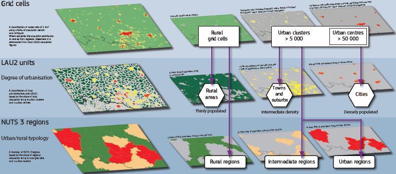
8 Introduction definitions Eurostat introduced GEOSTAT population grid Elimination of administrative units From address locations (geocoded point-based data) Or dissagregated from corresponding LAU2 Recalculation back to administrative units
9 Introduction definitions Eurostat introduced GEOSTAT population grid What is urban/rural area?
10 Introduction definitions Eurostat introduced GEOSTAT population grid What is urban/rural area? Rural area more than 50 % of its population lives in rural grid cells
11 Introduction definitions Eurostat introduced GEOSTAT population grid What is urban/rural area? Rural area more than 50 % of its population lives in rural grid cells A grid cell outside urban clusters
12 Introduction definitions Eurostat introduced GEOSTAT population grid What is urban/rural area? Rural area more than 50 % of its population lives in rural grid cells A grid cell outside urban clusters Urban clusters are contiguous grid cells of 1 km 2 with a density of at least 300 inhabitants per km 2 and a minimum population of 5,000


13 Introduction definitions Eurostat introduced GEOSTAT population grid What is urban/rural area? Rural area more than 50 % of its population lives in rural grid cells A grid cell outside urban clusters Urban clusters are contiguous grid cells of 1 km 2 with a density of at least 300 inhabitants per km 2 and a minimum population of 5,000
14 Introduction definitions Eurostat introduced GEOSTAT population grid What is urban/rural area? Rural area more than 50 % of its population lives in rural grid cells A grid cell outside urban clusters Urban clusters are contiguous grid cells of 1 km 2 with a density of at least 300 inhabitants per km 2 and a minimum population of 5,000 urban centre is a cluster of contiguous grid cells of 1 km 2 with a density of at least 1,500 inhabitants per km 2 and a minimum population of 50,000
 predominantly urban Less than 20 % in rural grid cells intermediate predominantly rural regions More than 50")
15 Introduction definitions Urban-rural typology (NUTS3) predominantly urban Less than 20 % in rural grid cells intermediate predominantly rural regions More than 50 % in rural grid cells OECD-EU typology Thinly populated area (rural area) Intermediate (towns and suburbs) Less than 50 % in rural grid cells and less than 50 % in high-density clusters Densely populated area (cities) At least 50 % in high-density clusters
16

17 DEGURBA EN: EuroGeographics for the administrative boundaries
18 Data
19 Data GISCO & Eurostat statistics Attribute data Hundreds of statistical data for NUTS3 (or higher) Total population for LAU2 Spatial administrative data Covering NUTS nomenclature Census data & Urban Audit Shp or personal GDB (except NUTS and country data)

20 Data GISCO & Eurostat statistics Communes & Total population
21 Data GISCO & Eurostat statistics Communes & Total population France and Greece (and few others as well, to be fair) COUNTRY COMM_RG_SPATIAL_DATA LAU_2017 LAU_2014 LAU_2013 COMMUNES_WITH_POPULATION COMMENTS FRANCE lakes. Fusion Arrondissements of Paris (20) data from LAU_ data from data from LAU_2013. COUNTRY COMM_RG_SPATIAL_DATA CENSUS_SPLAU_2017 CENSUS_20COMMUNES_WITH_POPULATION GREECE COMMENTS No match possible with data from LAU_2017, LAU_2016
22 Data GISCO & Eurostat statistics Communes & Total population Table: Table: Table: NUTS 3 LAU BE NUTS 3 BG322 LAU GAB12 NUTS 3 LAU DEF GIS Data: GIS Data: GIS Data: BE LAU 2 - Zemst BGHKV LAU 2 - Dryanovo DE LAU 2 - Schwabstedt
23 Data GISCO & Eurostat statistics Communes & Total population Table: NUTS 3 LAU DEF GIS Data: DE DE LAU 2 - Schwabstedt
24 Data GISCO & Eurostat statistics Communes & Total population Table: NUTS 3 LAU DEF GIS Data: DE DE LAU 2 - Schwabstedt
25 Fuzzy sets and logic approach

26 Motivation

27 Motivation - DEGURBA EN: EuroGeographics for the administrative boundaries

28 Motivation EN: EuroGeographics for the administrative boundaries
29 Motivation EN: EuroGeographics for the administrative boundaries

30 Motivation EN: EuroGeographics for the administrative boundaries

31 Motivation EN: EuroGeographics for the administrative boundaries
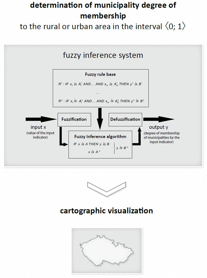
32 Fuzzy sets and logic approach It allows to smooth abrupt boundary values (on the contrary to Boolean logic) fig. a) It sets degree of membership in range from 0 to 1 fig. b) Closer to human-expert way of evaluation
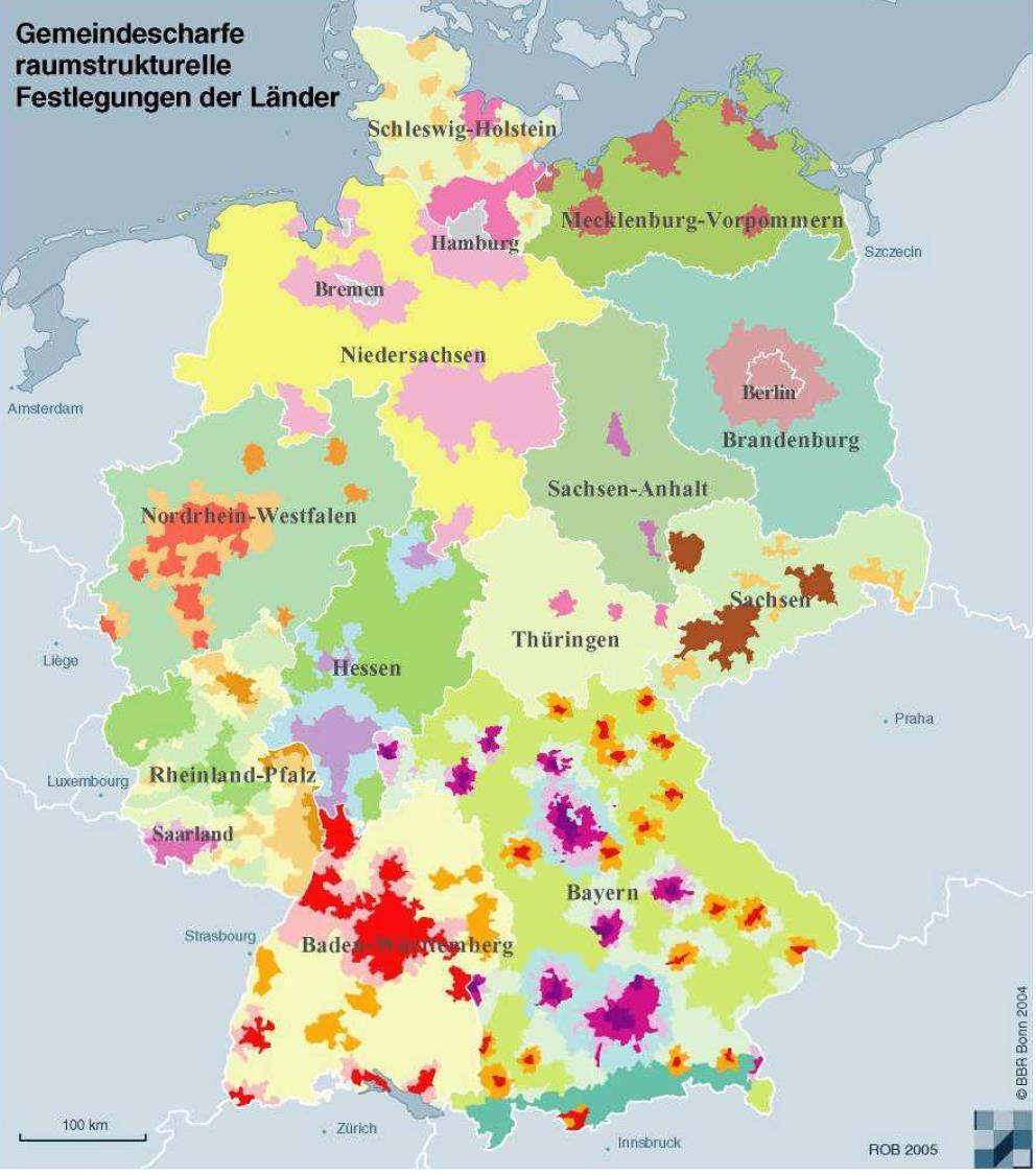
33 Rural-urban areas delimitation in Czechia Membership to urban area Membership to rural area μ A ~ A 1 x a b a 0 a x b x b x a 1300 a Total population 3700 b

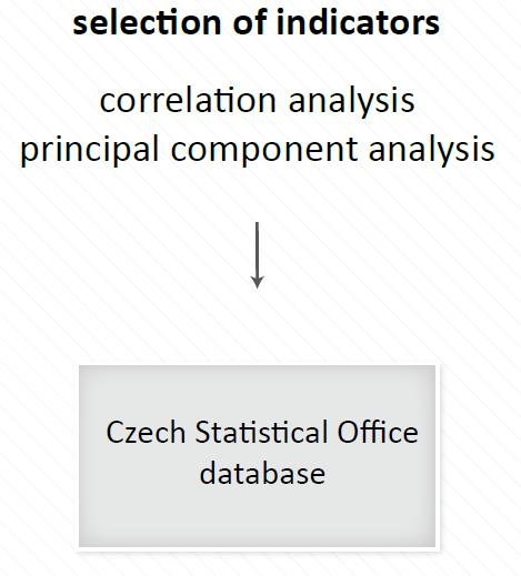
34 Rural-urban areas delimitation in Czechia LAU 2 units (6,248) Input data: - Total population - Total population per built-up area - Flats in family houses per total number of permanently occupied flats - Number of completed flats per 1,000 people - Population change - Driving distance to the county seat - Urbanized areas per overall municipality area Experts threshold values and weights

35 Rural-urban areas delimitation in Czechia

36 Rural-urban areas delimitation in Czechia
37 Publications Pászto, V. et al. (2015). Using a fuzzy inference system to delimit rural and urban municipalities in the Czech republic in 2010, Journal of Maps, 11 (2), pp DOI: / Pászto, V. et al. (2016) Membership of Czech municipalities to rural and urban areas: A fuzzy-based approach, Geografie-Sbornik CGS, 121 (1), pp WOS:
38 Rural-urban areas in Europe Total population threshold values (30%): 3500 (5000) 6500 Population density threshold values (30%): 210 (300) 390

39 Łukasiewicz t-norm EN: EuroGeographics for the administrative boundaries

40 Mean of fuzzy numbers EN: EuroGeographics for the administrative boundaries
41 Conclusions Urban/rural areas definitions in general are in a mess (together with LAU 2 data) Novel approach using GEOSTAT population grid Expert-based fuzzy approach Models rural urban continuum Closer to human perception (we do not think binary) and communication (vague terms) Computationally robust
gmail.com Karel MACKŮ Department of Geoinformatics, Faculty of Science, Palacký University Olomouc, Vit.")
42 What is a rural region? A comparative study on Eurostat data and methods for rural areas delimitation Vít PÁSZTO vit.paszto(at)gmail.com Karel MACKŮ Department of Geoinformatics, Faculty of Science, Palacký University Olomouc, Vit.Paszto@gmail.com
TERCET: A European regulation on statistical units and territorial typologies
 TERCET: A European regulation on statistical units and territorial typologies NUAC Meeting 10 May 2016 Eurostat Unit E4 Regulation (EC) No 1059/2003: - Establishes a classification of territorial units
How proximity to a city influences the performance of rural regions by Lewis Dijkstra and Hugo Poelman
 n 01/2008 Regional Focus A series of short papers on regional research and indicators produced by the Directorate-General for Regional Policy Remote Rural Regions How proximity to a city influences the
Developing a global, people-based definition of cities and settlements
 Developing a global, people-based definition of cities and settlements Cooperation between: Directorate General for Regional and, Joint Research Centre, EUROSTAT (European Commission, European Union) OECD,
THE NEW DEGREE OF URBANISATION
 THE NEW DEGREE OF URBANISATION EXECUTIVE SUMMARY This paper describes the new degree of urbanisation classification as approved by the Eurostat Labour Market Working Group in 2011. This classification
How the science of cities can help European policy makers: new analysis and perspectives
 How the science of cities can help European policy makers: new analysis and perspectives By Lewis Dijkstra, PhD Deputy Head of the Economic Analysis Unit, DG Regional and European Commission Overview Data
Compact guides GISCO. Geographic information system of the Commission
 Compact guides GISCO Geographic information system of the Commission What is GISCO? GISCO, the Geographic Information System of the COmmission, is a permanent service of Eurostat that fulfils the requirements
DUG User Guide. Version 2.1. Aneta J Florczyk Luca Maffenini Martino Pesaresi Thomas Kemper
 DUG User Guide Version 2.1 Aneta J Florczyk Luca Maffenini Martino Pesaresi Thomas Kemper 2017 i This publication is a Technical report by the Joint Research Centre (JRC), the European Commission s science
Populating urban data bases with local data
 Populating urban data bases with local data (ESPON M4D, Géographie-cités, June 2013 delivery) We present here a generic methodology for populating urban databases with local data, applied to the case of
Developing a global, peoplebased definition of cities and settlements
 Developing a global, peoplebased definition of cities and settlements By Lewis Dijkstra, Lewis.Dijkstra@ec.europa.eu Head of the Economic Analysis Sector DG for Regional and Urban Policy, Regional & Urban
ESPON Typology Compilation. Kai Böhme Sabine Zillmer, Kai Pflanz, Tomas Hanell & Petteri Niemi
 ESPON Typology Compilation Kai Böhme Sabine Zillmer, Kai Pflanz, Tomas Hanell & Petteri Niemi Scope of the study Tasks Compilation / assessment of existing typologies of typologies for ESPON Interim report
Global City Definition
 Regional Training Workshop on Human Settlement Indicators Global City Definition Dennis Mwaniki Global Urban Observatory, Research and Capacity Development Branch, UN-Habitat Bangkok, Thailand Outline
City definitions. Sara Ben Amer. PhD Student Climate Change and Sustainable Development Group Systems Analysis Division
 City definitions Sara Ben Amer PhD Student Climate Change and Sustainable Development Group Systems Analysis Division sbea@dtu.dk Contents 1. Concept of a city 2. Need for the city definition? 3. Challenges
TOWNs in Europe. Loris Servillo. Luxemburg, 12 December 2014
 Luxembourgish Small and Medium-Sized Towns in Europe: Challenges and Opportunities Ministère du Développement durable et des Infrastructures Luxemburg-Kirchberg TOWNs in Europe Loris Servillo Luxemburg,
Improving rural statistics. Defining rural territories and key indicators of rural development
 Improving rural statistics Defining rural territories and key indicators of rural development Improving rural statistics Improving Rural Statistics In 2016, the Global Strategy to improve Agricultural
Changes in population and industries in the rural areas of Finland: from analysis of administrative regions to a GIS based approach
 Toivo Muilu*, Jarmo Rusanen** * University of Oulu, Department of Geography, Agrifood Research Finland, Ruukki Research Station P.O. Box 3000, FIN-90014, Finland toivo.muilu@oulu.fi ** University of Oulu,
ANNEX 2: Defining and measuring rurality. Prepared by Dr Steve Goss
 ANNEX 2: Defining and measuring rurality Prepared by Dr Steve Goss June 2013 1 TABLE OF CONTENTS 1 Definitions of rurality in common use... 2 1.1 Measuring rurality... 2 1.1.1 OECD rural urban division...
Urban settlements delimitation using a gridded spatial support
 Urban settlements delimitation using a gridded spatial support Rita Nicolau 1, Elisa Vilares 1, Cristina Cavaco 1, Ana Santos 2, Mário Lucas 2 1 - General Directorate for Territory Development DGT, Portugal
Classifications of the Rural Areas in Bulgaria
 Centre for Research on Settlements and Urbanism Journal of Settlements and Spatial Planning J o u r n a l h o m e p a g e: http://jssp.reviste.ubbcluj.ro Classifications of the Rural Areas in Bulgaria
Refinement of the OECD regional typology: Economic Performance of Remote Rural Regions
 [Preliminary draft April 2010] Refinement of the OECD regional typology: Economic Performance of Remote Rural Regions by Lewis Dijkstra* and Vicente Ruiz** Abstract To account for differences among rural
Developing harmonised indicators on urban public transport in Europe
 Developing harmonised indicators on urban public transport in Europe Hugo Poelman European Commission DG Regional and Urban GIS team Regional May 2015 context EU Cohesion European Regional Development
Enhancing indicators on urban public transport in combination with geostatistics
 Enhancing indicators on urban public transport in combination with geostatistics Hugo Poelman European Commission DG and Urban GIS team April 2015 Harmonised indicators on European cities? EU-OECD definition
Sharthi Laldaparsad Statistics South Africa, Policy Research & Analysis. Sub-regional workshop on integration of administrative data,
 Sub-regional workshop on integration of administrative data, big data and geospatial information for the compilation of SDG indicators and International Workshop on Global Fundamental Geospatial Data Themes
BUILDING SOUND AND COMPARABLE METRICS FOR SDGS: THE CONTRIBUTION OF THE OECD DATA AND TOOLS FOR CITIES AND REGIONS
 BUILDING SOUND AND COMPARABLE METRICS FOR SDGS: THE CONTRIBUTION OF THE OECD DATA AND TOOLS FOR CITIES AND REGIONS STATISTICAL CAPACITY BUILDING FOR MONITORING OF SUSTAINABLE DEVELOPMENT GOALS Lukas Kleine-Rueschkamp
A WALK TO THE PARK? ASSESSING ACCESS TO GREEN AREAS IN EUROPE'S CITIES
 Working Papers A series of short papers on regional research and indicators produced by the Directorate-General for Regional Policy WP 01/2016 A WALK TO THE PARK? ASSESSING ACCESS TO GREEN AREAS IN EUROPE'S
Operational Definitions of Urban, Rural and Urban Agglomeration for Monitoring Human Settlements
 Operational Definitions of Urban, Rural and Urban Agglomeration for Monitoring Human Settlements By Markandey Rai United Nations Human Settlements Programme PO Box-30030 Nairobi, Kenya Abstract The United
Accessibility, rurality, remoteness an investigation on the Island of Sardinia, Italy
 UNIVERSITY OF SASSARI DIPARTIMENTO DI INGEGNERIA DEL TERRITORIO UNIVERSITY OF CAGLIARI DIPARTIMENTO DI FISICA AND DIPARTIMENTO DI INGEGNERIA DEL TERRITORIO Accessibility, rurality, remoteness an investigation
Territorial evidence for a European Urban Agenda TOWN in Europe
 Territorial evidence for a European Urban Agenda TOWN in Europe Loris Servillo Brussels, 25 November 2014 Outline 1. SMSTs in the EU territory 2. General vs specific trends? 3. Evidences for more appropriated
2 European cities. Introduction. Urbanisation. 36 Eurostat regional yearbook 2010 eurostat. The spatial dimension. The topics.
 European cities 2 European cities ( 1 ) Council of the European Union, Review of the EU sustainable development strategy (EU SDS) Renewed strategy, 10117/06. ( 2 ) Eurostat, Sustainable development in
Are EU Rural Areas still Lagging behind Urban Regions? An Analysis through Fuzzy Logic
 Are EU Rural Areas still Lagging behind Urban Regions? An Analysis through Fuzzy Logic Francesco Pagliacci Department of Economics and Social Sciences Università Politecnica delle Marche Ancona (Italy)
TRACC Transport Accessibility at Regional/Local Scale and Patterns in Europe
 TRACC Transport Accessibility at Regional/Local Scale and Patterns in Europe Applied Research 2013/1/10 Final Report Version 06/02/2015 Volume 3 TRACC Regional Case Study Book ESPON 2013 I This report
Rural Alabama. Jennifer Zanoni. Geography Division U.S. Census Bureau. Alabama State Data Center 2018 Data Conference Tuscaloosa, Alabama
 Rural Alabama Jennifer Zanoni Geography Division U.S. Census Bureau Alabama State Data Center 2018 Data Conference Tuscaloosa, Alabama May 17, 2018 Agenda Census Geography Urban/Rural Definitions County-based
INDICATOR Ratio of land consumption rate to population growth rate
 UN-GGIM: Europe Work Group on Data Integration subgroup 2 The territorial dimension in SDG indicators: the contribution of geospatial data and analysis sand its combination with statistical data INDICATOR
European Forum for Geography & Statistics Conference 2018
 European Forum for Geography & Statistics Conference 2018 Welcome speech Dr. Janusz Dygaszewicz EFGS President Director of ICT Systems, Geostatistics and Census Department Statistics Poland Helsinki, Finland,
Some practices of Geospatial coding and referencing statistics in Finland and in Europe
 Some practices of Geospatial coding and referencing statistics in Finland and in Europe Marja Tammilehto-Luode UN Expert Group on the Integration of Statistical and Geospatial Information 30.10. 1.11.2013
Typology of Rural Regions in Europe RUFUS. Johanna Scholz& Sylvia Herrmann. A regional typology as instrument for integrative rural development
 Typology of Rural Regions in Europe A regional typology as instrument for integrative rural development RUFUS Rural Future Networks Workshop Hannover 25-26 August 2010 `Diversities of rural areas in Europe
Kai Böhme Kai Böhme Sabine Zillmer, Kai Pflanz, Tomas Hanell & Petteri Niemi
 ESPON Typology ogy Compilation o Kai Böhme Kai Böhme Sabine Zillmer, Kai Pflanz, Tomas Hanell & Petteri Niemi Scope of the study Tasks Compilation / assessment of existing typologies of typologies for
European Regional and Urban Statistics
 European Regional and Urban Statistics Dr. Berthold Feldmann berthold.feldmann@ec.europa.eu Eurostat Structure of the talk Regional statistics in the EU The tasks of Eurostat Regional statistics Urban
Swedish examples on , and
 Swedish examples on 11.2.1, 11.3.1 and 11.7.1 Marie Haldorson, Director Seminar in Nairobi 7 Dec 2018 SDG Indicator Tests by Countries in Europe GEOSTAT 3: ESS Project with a purpose to guide countries
A WALK TO THE PARK? ASSESSING ACCESS TO GREEN AREAS IN EUROPE'S CITIES
 A WALK TO THE PARK? ASSESSING ACCESS TO GREEN AREAS IN EUROPE'S CITIES UPDATE USING COMPLETED COPERNICUS URBAN ATLAS DATA Hugo Poelman Working Papers A series of short papers on regional research and indicators
USING DOWNSCALED POPULATION IN LOCAL DATA GENERATION
 USING DOWNSCALED POPULATION IN LOCAL DATA GENERATION A COUNTRY-LEVEL EXAMINATION CONTENT Research Context and Approach. This part outlines the background to and methodology of the examination of downscaled
Governance and Functional Urban Areas CEMAT Conference
 Governance and Functional Urban Areas CEMAT Conference Mart Grisel Bucharest, Romania 30/05/2017 FUA: various definitions KEY ASPECTS: CITY & COMMUTING AREA The area occupied by a large city and its surrounding
The Combination of Geospatial Data with Statistical Data for SDG Indicators
 Session x: Sustainable Development Goals, SDG indicators The Combination of Geospatial Data with Statistical Data for SDG Indicators Pier-Giorgio Zaccheddu Fabio Volpe 5-8 December2018, Nairobi IAEG SDG
PASSENGER RAIL ACCESSIBILITY IN EUROPE'S BORDER AREAS
 PASSENGER RAIL ACCESSIBILITY IN EUROPE'S BORDER AREAS HUGO POELMAN AND LINDE ACKERMANS Working Papers A series of short papers on regional research and indicators produced by the Directorate-General for
Towards indicators of proximity to services in Europe's major cities
 Towards indicators of proximity to services in Europe's major cities Enhancing the analytical use of the GMES Urban Atlas in combination with population distribution data Hugo Poelman European Commission
Urban-rural relations in Europe
 Urban-rural relations in Europe Typology of urban and rural characteristics developed by the ESPON 1.1.2 project Kaisa Schmidt-Thomé 14.12.2006 Sevilla JRC/IPTS Rural typologies -workshop ESPON 2006 Programme
CHANGES IN THE STRUCTURE OF POPULATION AND HOUSING FUND BETWEEN TWO CENSUSES 1 - South Muntenia Development Region
 TERITORIAL STATISTICS CHANGES IN THE STRUCTURE OF POPULATION AND HOUSING FUND BETWEEN TWO CENSUSES 1 - South Muntenia Development Region PhD Senior Lecturer Nicu MARCU In the last decade, a series of structural
Regional economy upgrading triple helix at work? Some selected cases from the Czech republic (and Central Eastern Europe) Pavel Ptáček
 Pavel Ptáček") Regional economy upgrading triple helix at work? Some selected cases from the Czech republic (and Central Eastern Europe) Pavel Ptáček Department of Geography Palacký University in Olomouc, Czech republic
Regional economy upgrading triple helix at work? Some selected cases from the Czech republic (and Central Eastern Europe) Pavel Ptáček Department of Geography Palacký University in Olomouc, Czech republic
OECD PERSPECTIVE ON METROPOLITAN AREAS
 Final conference of ESPON Targeted Analysis SPIMA (Spatial dynamics and strategic planning in Metropolitan Areas) Brussels, 6 February 2018 OECD PERSPECTIVE ON METROPOLITAN AREAS Soo-Jin KIM OECD Centre
The European Forum for Geospatial Statistics Benefits and challenges of INSPIRE in the field of statistics
 INSPIRE Conference 2016 Barcelona, Spain 26th 30th September 2016 The European Forum for Geospatial Statistics Benefits and challenges of INSPIRE in the field of statistics Janusz Dygaszewicz EFGS President
Land Use and Land cover statistics (LUCAS)
") EUROPEAN COMMISSION EUROSTAT Directorate E: Sectoral and regional statistics Doc. ENV/DIMESA/7.1/2012 Original in EN Agenda point 7.1 Land Use and Land cover statistics (LUCAS) DIMESA Directors' Meeting
EUROPEAN COMMISSION EUROSTAT Directorate E: Sectoral and regional statistics Doc. ENV/DIMESA/7.1/2012 Original in EN Agenda point 7.1 Land Use and Land cover statistics (LUCAS) DIMESA Directors' Meeting
The European Commission s science and knowledge service. Joint Research Centre
 The European Commission s science and knowledge service Joint Research Centre Global Urbanisation Pattern observed with EO data Thomas Kemper & GHSL team Urban Studies Symposium, University of Twente,
SAHEL AND. Club WEST AFRICA
 SAHEL AND Club WEST AFRICA Informing policies for Africa s urban future Africa is projected to have the fastest urban growth rate in the world by 2050, Africa s cities will be home to an additional 950
ESDIN Results from a Crossborder INSPIRE Preparatory Project. Jörgen Hartnor, Lantmäteriet.
 ESDIN Results from a Crossborder INSPIRE Preparatory Project Jörgen Hartnor, Lantmäteriet www.esdin.eu Ett econtentplus Best Practice Network projekt September 2008 February 2011 Coordinated by EuroGeographics
Calculating the Natura 2000 network area in Europe: The GIS approach
 Calculating the Natura 2000 network area in Europe: The GIS approach 1. INTRODUCTION A precise area calculation is needed to check to what extent member states have designated Natura 2000 sites of their
Internal migration patterns in the EU and the future population development of large cities in Germany
 Internal migration patterns in the EU and the future population development of large cities in Germany Prof. Dr. Paul Gans Chair of Economic Geography Department of Economics University of Mannheim D-68131
Figure 10. Travel time accessibility for heavy trucks
 Figure 10. Travel time accessibility for heavy trucks Heavy truck travel time from Rotterdam to each European cities respecting the prescribed speed in France on the different networks - Road, motorway
Cross-Border Continuity of Socio-economic Indicators: Case Study of Czechia and Poland
 Cross-Border Continuity of Socio-economic Indicators: Case Study of Czechia and Poland Pászto V *1, Macků K 1, Burian J 1 and Pánek J 2 1 Department of Geoinformatics, Palacký University Olomouc (Czech
The History Behind Census Geography
 The History Behind Census Geography Michael Ratcliffe Geography Division US Census Bureau Kentucky State Data Center Affiliate Meeting August 5, 2016 Today s Presentation A brief look at the history behind
Measuring regional economies in OECD countries
 OECD Regions at a Glance 2013 OECD 2013 Measuring regional economies in OECD countries What do regional data tell us? Traditionally, regional policy analysis has used data collected for administrative
A proposal for building an infrastructure for European geospatial statistics
 A proposal for building an infrastructure for European geospatial statistics Marie Haldorson, Statistics Sweden Ekkehard Petri, Eurostat What is geospatial statistics? The location, extent or spatial relations
Progress of UN-GGIM: Europe Working Group A on Core Data
 INSPIRE KEN 13 December 2016 Progress of UN-GGIM: Europe Working Group A on Core Data François Chirié, Dominique Laurent, IGN France Plan Introduction Objectives of the working group with respect to INSPIRE
Metropolitan Areas in Italy
 Metropolitan Areas in Italy Territorial Integration without Institutional Integration Antonio G. Calafati UPM-Faculty of Economics Ancona, Italy www.antoniocalafati.it European Commission DG Regional Policy
GISCO Working Party Meeting. 8 March 2012 Luxembourg. The ESPON 2013 Programme: State of Affairs. Marjan van Herwijnen project expert in the ESPON CU
 GISCO Working Party Meeting 8 March 2012 Luxembourg The ESPON 2013 Programme: State of Affairs Marjan van Herwijnen project expert in the ESPON CU The ESPON 2013 Programme Role in Structural Funds 2007-2013:
How rural the EU RDP is? An analysis through spatial funds allocation
 How rural the EU RDP is? An analysis through spatial funds allocation Beatrice Camaioni, Roberto Esposti, Antonello Lobianco, Francesco Pagliacci, Franco Sotte Department of Economics and Social Sciences
PROFECY Processes, Features and Cycles of Inner Peripheries in Europe
 PROFECY Processes, Features and Cycles of Inner Peripheries in Europe (Inner Peripheries: National territories facing challenges of access to basic services of general interest) Applied Research Final
The History Behind Census Geography
 The History Behind Census Geography Michael Ratcliffe Geography Division US Census Bureau Tennessee State Data Center August 8, 2017 Today s Presentation A brief look at the history behind some of the
Final report for the Expert Group on the Integration of Statistical and Geospatial Information, May 2015
 Final report for the Expert Group on the Integration of Statistical and Geospatial Information, May 2015 Global geographic classification and geocoding practices Executive summary This final report was
Population Grid Statistics
 Population Grid Statistics from Hybrid Sources Walter Radermacher Eurostat, the statistical office of the European Union, collects pan-european statistics based on administrative regions (NUTS), which
Urbanisation Dynamics in West Africa AFRICAPOLIS I, 2015 UPDATE
 Public Disclosure Authorized Public Disclosure Authorized Urbanisation Dynamics in West Africa 1950 2010 AFRICAPOLIS I, 2015 UPDATE uy François Moriconi-Ebrard, Dominique Harre, Philipp Heinrigs Washington
Towards a Polycentric Europe
 Towards a Polycentric Europe European Spatial Perceptions The Blue Banana Brunet, 1989 A Bunch of Grapes Kunzmann & Wegener, 1991 Economic Imbalances Core area of the EU: Pentagon of the metropolises of
TOWN Small and medium sized towns in their functional territorial context
 TOWN Small and medium sized towns in their functional territorial context Applied Research 2013/1/23 Interim Report Version 28/01/2013 i This report presents the interim results of an Applied Research
REGIONAL PATTERNS OF KIS (KNOWLEDGE INTENSIVE SERVICES) ACTIVITIES: A EUROPEAN PERSPECTIVE
 ACTIVITIES: A EUROPEAN PERSPECTIVE") REGIONAL PATTERNS OF KIS (KNOWLEDGE INTENSIVE SERVICES) ACTIVITIES: A EUROPEAN PERSPECTIVE Esther Schricke and Andrea Zenker Fraunhofer-Institut für System- und Innovationsforschung (ISI) Karlsruhe evoreg-workshop
REGIONAL PATTERNS OF KIS (KNOWLEDGE INTENSIVE SERVICES) ACTIVITIES: A EUROPEAN PERSPECTIVE Esther Schricke and Andrea Zenker Fraunhofer-Institut für System- und Innovationsforschung (ISI) Karlsruhe evoreg-workshop
I&CLC2000 in support to new policy initiatives (INSPIRE, GMES,..)
") I&CLC2000 in support to new policy initiatives (INSPIRE, GMES,..) Manfred Grasserbauer, Director Joint Research Centre Institute for Environment and Sustainability 1 IMAGE 2000 European mosaic of satellite
I&CLC2000 in support to new policy initiatives (INSPIRE, GMES,..) Manfred Grasserbauer, Director Joint Research Centre Institute for Environment and Sustainability 1 IMAGE 2000 European mosaic of satellite
Economic Growth in European City Regions A New Turn for Peripheral Regions in CEE Member States After the EU Enlargements of 2004/2007?
 Economic Growth in European City Regions A New Turn for Peripheral Regions in CEE Member States After the EU Enlargements of /2007? SCORUS Conference A new urban agenda? Uwe Neumann, Rüdiger Budde, Christoph
APPLYING THE END FOR LOMBARDY S AIRPORTS
 APPLYING THE END FOR LOMBARDY S AIRPORTS Angela Alberici, Maurizio Bassanino, Paolo Deforza, Nadia Fibbiani, Paola Maggi, Mauro Mussin, Valeria Spirolazzi ARPA Lombardia Via Francesco Restelli 3\1, 20124,
Rules of the territorial division
 Rules of the territorial division Janusz Dygaszewicz Central Statistical Office of Poland Jerusalem, 4-7 December 2016 Rules of territory division (the Polish case) The area of each unit of territorial
A proposal for building an infrastructure for European geospatial statistics. Marie Haldorson, Statistics Sweden Ekkehard Petri, Eurostat
 A proposal for building an infrastructure for European geospatial statistics Marie Haldorson, Statistics Sweden Ekkehard Petri, Eurostat What is geospatial statistics? The location, extent or spatial relations
2.- Area of built-up land
 2.- Area of built-up land Key message Over recent decades, built-up areas have been steadily increasing all over Europe. In Western European countries, built-up areas have been increasing faster than the
DEFINING AND MEASURING WORLD-METRO REGIONS FOR INTERNATIONAL COMPARISONS
 DEFINING AND MEASURING WORLD-METRO REGIONS FOR INTERNATIONAL COMPARISONS Mario Piacentini, OECD 27th Scorus Conference, 11-13 August 2010, Latvia Why we need comparable measures of city performance Growing
SPIMA Spatial dynamics and strategic planning in metropolitan areas
 SPIMA Spatial dynamics and strategic planning in metropolitan areas Dr. Vanya Simeonova Wageningen Environmental Research Wageningen University and research, The Netherlands Key outcomes: SPIMA Framework
Helsinki. Oslo. Stockholm. Tallinn. Riga. København. Minsk. Vilnius. Warszawa. Berlin. Praha. Luxembourg. Bratislava Budapest. Wien.
 M4D NEWSLETTER FOR ESPON PROJECTS ulti-dimensional Database Design & Development MULTI-DIMENSIONAL DATA DESIGN AND DEVELOPMENT N 3 DECEMBER-JUNE 2013 EDITO This third issue of the ESPON M4D newsletter
The Combination of Geospatial Data with Statistical Data for SDG Indicators
 Session 3: Sustainable Development Goals, SDG indicators The Combination of Geospatial Data with Statistical Data for SDG Indicators Pier-Giorgio Zaccheddu (with the assistance of Francisco Vala & Cátia
Module 3 Indicator Land Consumption Rate to Population Growth Rate
 Regional Training Workshop on Human Settlement Indicators Module 3 Indicator 11.3.1 Land Consumption Rate to Population Growth Rate Dennis Mwaniki Global Urban Observatory, Research and Capacity Development
Analysis of travel-to-work patterns and the identification and classification of REDZs
 Analysis of travel-to-work patterns and the identification and classification of REDZs Dr David Meredith, Teagasc, Spatial Analysis Unit, Rural Economy Development Programme, Ashtown, Dublin 15. david.meredith@teagasc.ie
Labour Market Areas in Italy. Sandro Cruciani Istat, Italian National Statistical Institute Directorate for territorial and environmental statistics
 Labour Market Areas in Italy Sandro Cruciani Istat, Italian National Statistical Institute Directorate for territorial and environmental statistics Workshop on Developing European Labour Market Areas Nuremberg,
1. Demand for property on the coast
 1. Demand for property on the coast Key message Irrespective of density and location, population in Europe in general tends to concentrate in coastal areas. Detailed spatial elaboration of processes shows
Progress of UN-GGIM: Europe Working Group A on Core Data
 PolicyKEN Budapest 29 November 2016 Progress of UN-GGIM: Europe Working Group A on Core Data François Chirié, Dominique Laurent, IGNF Core data context Background and purpose Aim of Work Group A to propose
Identification of Urban Areas Using Raster Spatial Analysis
 Identification of Urban Areas Using Raster Spatial Analysis Abstract. Miguel Valentim * Instituto Superior Técnico, Universidade Técnica de Lisboa The impacts on the environment and landscape from the
The Added Value of Geospatial Data in a Statistical Office. Pedro Diaz Munoz Director Sectoral and Regional Statistics EUROSTAT European Commission
 The Added Value of Geospatial Data in a Statistical Office Pedro Diaz Munoz Director Sectoral and Regional Statistics EUROSTAT European Commission Why integrate Responsibility of all the information we
Defining Metropolitan Regions (MRs): coping with complexity
: coping with complexity") OECD Paris 27 November 2006 Defining Metropolitan Regions (MRs): coping with complexity Mike Coombes CURDS Newcastle University Britain Acknowledgements CURDS colleagues eg. Simon Raybould Past sponsors
OECD Paris 27 November 2006 Defining Metropolitan Regions (MRs): coping with complexity Mike Coombes CURDS Newcastle University Britain Acknowledgements CURDS colleagues eg. Simon Raybould Past sponsors
Growth Trends and Characteristics of OECD Rural Regions
 Please cite this paper as: Garcilazo, E. (2013), Growth Trends and Characteristics of OECD Rural Regions, OECD Regional Development Working Papers, 2013/10, OECD Publishing, Paris. http://dx.doi.org/10.1787/5k4522x3qk9q-en
The more, the merrier? Urbanization and regional GDP growth in Europe over the 20th century
 The more, the merrier? Urbanization and regional GDP growth in Europe over the 20th century Kerstin Enflo * Anna Missiaia Joan Rosés Abstract Preliminary draft prepared for the Economic History Society
Intercomparison Exercise of Spatial Representativeness Methods
 Intercomparison Exercise of Spatial Representativeness Methods Kristina Eneroth and Sanna Silvergren SLB-analys Stockholm Health and Environment Administration kristina@slb.nu SLB-analys - our organisation
CHAPTER 6 RURAL EMPOWERMENT
 CHAPTER 6 RURAL EMPOWERMENT While Europe is a highly urbanised continent, 20% of its population live in rural areas. Furthermore, while agriculture accounts for only 2% of its GDP and 5.7% of its employment,
The European territory: Strategic developmentd
 The European territory: Strategic developmentd Peter Mehlbye Workshop Strategic Development Catalonia 11 June 2002 THE LECTURE Structure I. Territorial trends II. Strategy for European spatial development
reviewed paper 1 ABSTRACT 2 INTRODUCTION
 reviewed paper European Spatial indicators temporal development and quality aspects Klaus STEINNOCHER, Gebhard BANKO, Mario KÖSTL, Frederic PETRINI-MONTEFERRI DI. Dr. Klaus Steinnocher, ARC systems research,
Merging statistics and geospatial information
 Merging statistics and geospatial information Demography / Commuting / Spatial planning / Registers Mirosław Migacz Chief GIS Specialist Janusz Dygaszewicz Director Central Statistical Office of Poland
UN-GGIM: An Overview Stefan Schweinfest, Director (UNSD) Bangkok, 27 March 2015
 Bangkok, 27 March 2015") UN-GGIM: An Overview Stefan Schweinfest, Director (UNSD) Bangkok, 27 March 2015 ggim.un.org UN-GGIM: A global initiative Formal inter-governmental UN Committee of Experts to: Discuss, enhance and coordinate
UN-GGIM: An Overview Stefan Schweinfest, Director (UNSD) Bangkok, 27 March 2015 ggim.un.org UN-GGIM: A global initiative Formal inter-governmental UN Committee of Experts to: Discuss, enhance and coordinate
US Census Bureau Geographic Entities and Concepts. Geography Division
 US Census Bureau Geographic Entities and Concepts Geography Division Geographic Concepts Addresses vs. Geographic features and entities Legal/Administrative vs. Statistical Nesting relationships (or the
Research report to support the Latvian EU Presidency 2015
 Challenges of Smalll and Medium-Sized Urban Areas (SMUAs), their economic growth potential and impact on territorial development in the European Union and Latvia Research report to support the Latvian