Spatio-Temporal Analytics of Network Data
|
|
|
- Sarah Wiggins
- 5 years ago
- Views:
Transcription

1 Spatio-Temporal Analytics of Network Data Tao Cheng, James Haworth SpaceTimeLab Team University College London GIS Ostrava Geoinformatics for Intelligent Transportation j.haworth@ucl.ac.uk; tao.cheng@ucl.ac.uk


2

3

4 Why Spatio-temporal Analytics? Spatio-temporal data pose unique problems Heterogeneity/Nonstationarity Dynamics Interactions and associations Volume Human Behaviour Different challenge to modelling non-spatial data.


5 What is Spatio-temporal Analytics? Analytics: Information resulting from the systematic analysis of data or statistics (Oxford Dictionary) Representation Analysis Modelling and Forecasting Spatio-temporal Data Visualisation Clustering Simulation
6 Space-time modelling and forecasting - The challenge lies in the non-stationary (heterogeneity) and non-linearity of space-time data. Statistical Approaches STARIMA models space-time geostatistical models spatial panel data models space-time GWR How to calibrate the spatiotemporal autocorrelations is the bottleneck. Machine Learning Approaches Artificial Neural networks (ANNs) Self-organizing maps Support vector regression (SVR) Nonparametric Regression The interpretability of machine learning is low Computationally intensive
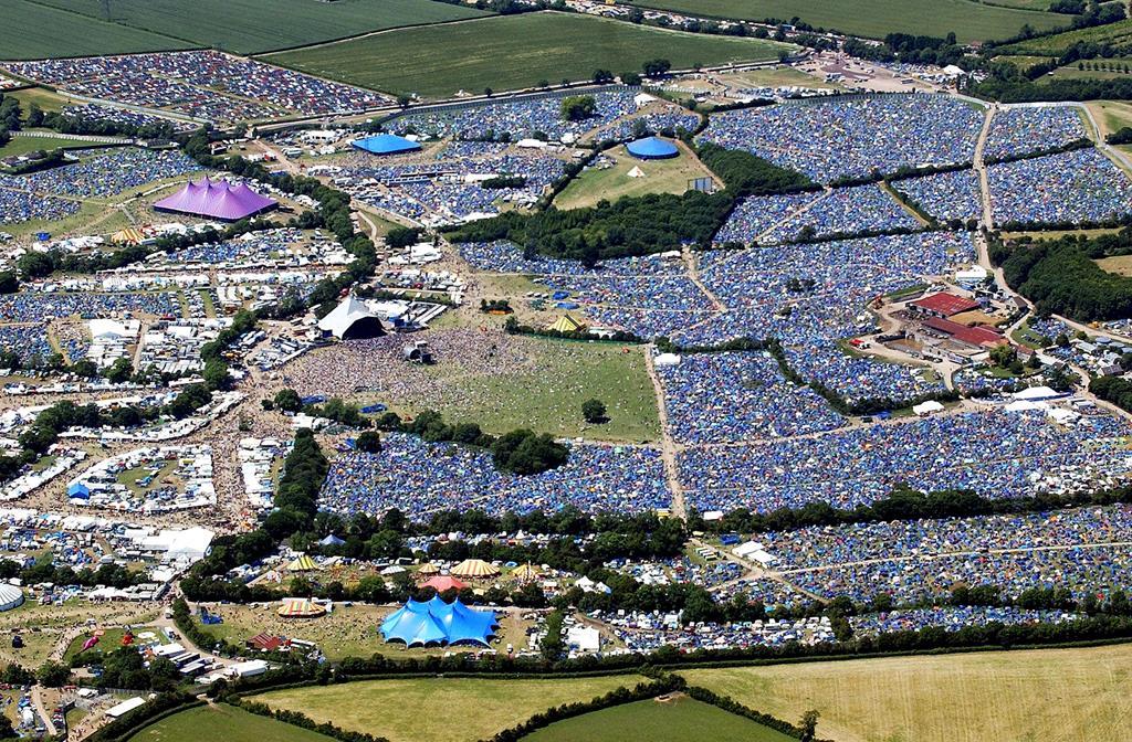
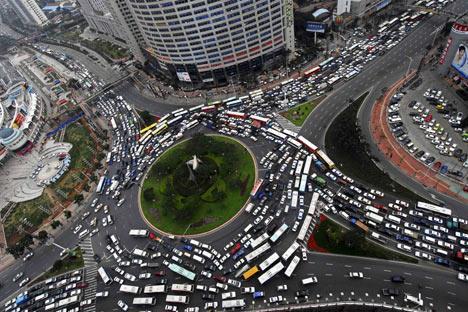
7 Challenges in forecasting spatio-temporal data How to: Collect/analyse/use large amounts of data in real time. deal with missing and noisy data on the fly. integrate data from various sources. quantify the effect of network structure on network performance. detect and respond to abnormal (non-recurrent) events. Abnormal congestion event
8 Space-time clustering - to extract meaningful patterns (clusters) To detect outliers or emerging phenomena (epidemic outbreaks or traffic congestion) Considering the spatial, temporal and thematic attributes seamlessly and simultaneously, and the dynamicity in the data is the most difficult challenge in spatio-temporal clustering Spatio-temporal scan statistics (STSS) sheds lights on this aspect (GAM -> SSS -> STSS) Efforts are needed to improve our understanding of the expected value.


9 Incident detection and response using Twitter data Tom Wicks
10 Space-time Simulation - Imitation of the evolution of a process over space and time. Simulation of networks usually based on physical process. Traffic flow theory Bottleneck lies in accurately representing human behaviour. Individual decisions (micro level) lead to large scale effects (macro level). Humans behaviour is not optimal. Agent based modelling is one choice.

11 Ed Manley Agent-based Simulation Regent s Park Saturation > 1.5 Hyde Park


12 Adel Bolbol Fernandez - Understanding Travel Behaviours from GPS Data Logs GPS Data SVM Classification, Spatial Clustering, Map Matching, Spatial Analysis Accuracy achieved > 88% Mode of Transport GPS Testing data: 110 participants in London 2 Months/ participant 20 second collection rate
13 Space-time visualisation (visual analytics) - explores the patterns hidden in the large data sets using advanced (analytical) visualization and animation static 2D maps 3D wall maps and isosurface (hotspots in space-time) Tools: Visual Analytics and Geovisual Analytics Methods are needed to show evolution and dissipation in space and time simultaneously (e.g. crime or traffic congestion) Still, real-time visualization of dynamic processes is still very challenging due to large volume and high dimensions of the data.


14 Isosurface for visualising traffic congestion Garavig Tanaksaranond

15 Wallmaps for visualising traffic congestion Tube Strike- 17:00 6 Sep :00 7 Sep 2010 Garavig Tanaksaranond

16 Garavig Tanaksaranond Space-Time Visualisation of Traffic Congestion Visualising Congestion Build-up in London 3D Wall Map Travel Time Interactive Visualization Tool
17 Research Frontiers in Spatio-temporal Analytics 1) Modelling and forecasting - nonlinearlity & nonstationarity, abnormal events 2) Tools to capture/illustrate the processes - emergence and tipping points - simulating behaviour (macroscopic properties alter because of accumulated microscopic changes) 3) Spatio-temporal dependence and interactions - impact of activities on the network - interactions between networks BigData empirical theory and testing

18 Thank you. Questions? standard.cege.ucl.ac.uk
Spatio Temporal Analysis of Network Data. Dr Tao Cheng
 Spatio Temporal Analysis of Network Data and Road ddevelopments Dr Tao Cheng Dr Tao Cheng Senior Lecturer in GeoInformatics Department of Civil, Environmental & Geomatic Engineering, UCL Data quality and
Graphical LASSO for local spatio-temporal neighbourhood selection
 Graphical LASSO for local spatio-temporal neighbourhood selection James Haworth 1,2, Tao Cheng 1 1 SpaceTimeLab, Department of Civil, Environmental and Geomatic Engineering, University College London,
Improving forecasting under missing data on sparse spatial networks
 Improving forecasting under missing data on sparse spatial networks J. Haworth 1, T. Cheng 1, E. J. Manley 1 1 SpaceTimeLab, Department of Civil, Environmental and Geomatic Engineering, University College
Clustering Analysis of London Police Foot Patrol Behaviour from Raw Trajectories
 Clustering Analysis of London Police Foot Patrol Behaviour from Raw Trajectories Jianan Shen 1, Tao Cheng 2 1 SpaceTimeLab for Big Data Analytics, Department of Civil, Environmental and Geomatic Engineering,
Space-Time Kernels. Dr. Jiaqiu Wang, Dr. Tao Cheng James Haworth University College London
 Space-Time Kernels Dr. Jiaqiu Wang, Dr. Tao Cheng James Haworth University College London Joint International Conference on Theory, Data Handling and Modelling in GeoSpatial Information Science, Hong Kong,
EEE 241: Linear Systems
 EEE 4: Linear Systems Summary # 3: Introduction to artificial neural networks DISTRIBUTED REPRESENTATION An ANN consists of simple processing units communicating with each other. The basic elements of
Detecting Emerging Space-Time Crime Patterns by Prospective STSS
 Detecting Emerging Space-Time Crime Patterns by Prospective STSS Tao Cheng Monsuru Adepeju {tao.cheng@ucl.ac.uk; monsuru.adepeju.11@ucl.ac.uk} SpaceTimeLab, Department of Civil, Environmental and Geomatic
Stochastic Hydrology. a) Data Mining for Evolution of Association Rules for Droughts and Floods in India using Climate Inputs
 Data Mining for Evolution of Association Rules for Droughts and Floods in India using Climate Inputs") Stochastic Hydrology a) Data Mining for Evolution of Association Rules for Droughts and Floods in India using Climate Inputs An accurate prediction of extreme rainfall events can significantly aid in policy
Stochastic Hydrology a) Data Mining for Evolution of Association Rules for Droughts and Floods in India using Climate Inputs An accurate prediction of extreme rainfall events can significantly aid in policy
GIS Ostrava 2014 Final resume
 GIS Ostrava 2014 Final resume The 11 th Symposium GIS Ostrava 2014 was held in the New Hall of the Technical University of Ostrava for three days since Jan 27th to Jan 29th. Similarly, as in previous years,
Belief Propagation for Traffic forecasting
 Belief Propagation for Traffic forecasting Cyril Furtlehner (INRIA Saclay - Tao team) context : Travesti project http ://travesti.gforge.inria.fr/) Anne Auger (INRIA Saclay) Dimo Brockhoff (INRIA Lille)
Caesar s Taxi Prediction Services
 1 Caesar s Taxi Prediction Services Predicting NYC Taxi Fares, Trip Distance, and Activity Paul Jolly, Boxiao Pan, Varun Nambiar Abstract In this paper, we propose three models each predicting either taxi
A new metric of crime hotspots for Operational Policing
 A new metric of crime hotspots for Operational Policing Monsuru Adepeju *1, Tao Cheng 1, John Shawe-Taylor 2, Kate Bowers 3 1 SpaceTimeLab for Big Data Analytics, Department of Civil, Environmental and
Models to carry out inference vs. Models to mimic (spatio-temporal) systems 5/5/15
 systems 5/5/15") Models to carry out inference vs. Models to mimic (spatio-temporal) systems 5/5/15 Ring-Shaped Hotspot Detection: A Summary of Results, IEEE ICDM 2014 (w/ E. Eftelioglu et al.) Where is a crime source?
Models to carry out inference vs. Models to mimic (spatio-temporal) systems 5/5/15 Ring-Shaped Hotspot Detection: A Summary of Results, IEEE ICDM 2014 (w/ E. Eftelioglu et al.) Where is a crime source?
IV Course Spring 14. Graduate Course. May 4th, Big Spatiotemporal Data Analytics & Visualization
 Spatiotemporal Data Visualization IV Course Spring 14 Graduate Course of UCAS May 4th, 2014 Outline What is spatiotemporal data? How to analyze spatiotemporal data? How to visualize spatiotemporal data?
MODELLING TRAFFIC FLOW ON MOTORWAYS: A HYBRID MACROSCOPIC APPROACH
 Proceedings ITRN2013 5-6th September, FITZGERALD, MOUTARI, MARSHALL: Hybrid Aidan Fitzgerald MODELLING TRAFFIC FLOW ON MOTORWAYS: A HYBRID MACROSCOPIC APPROACH Centre for Statistical Science and Operational
Approaches to Spatial Analysis. Flora Vale, Linda Beale, Mark Harrower, Clint Brown Esri Redlands
 Approaches to Spatial Analysis Flora Vale, Linda Beale, Mark Harrower, Clint Brown Esri Redlands Analysis (noun) Detailed examination of the elements or structure of something, as a basis for discussion,
Spatial Analysis 1. Introduction
 Spatial Analysis 1 Introduction Geo-referenced Data (not any data) x, y coordinates (e.g., lat., long.) ------------------------------------------------------ - Table of Data: Obs. # x y Variables -------------------------------------
CHAPTER 7 CONCLUSION AND FUTURE WORK
 159 CHAPTER 7 CONCLUSION AND FUTURE WORK 7.1 INTRODUCTION Nonlinear time series analysis is an important area of research in all fields of science and engineering. It is an important component of operations
arxiv: v1 [q-fin.st] 27 Sep 2007
![arxiv: v1 [q-fin.st] 27 Sep 2007](/thumbs/95/126120549.jpg "arxiv: v1 [q-fin.st] 27 Sep 2007") Interest Rates Mapping M.Kanevski a,, M.Maignan b, A.Pozdnoukhov a,1, V.Timonin a,1 arxiv:0709.4361v1 [q-fin.st] 27 Sep 2007 a Institute of Geomatics and Analysis of Risk (IGAR), Amphipole building, University
Interest Rates Mapping M.Kanevski a,, M.Maignan b, A.Pozdnoukhov a,1, V.Timonin a,1 arxiv:0709.4361v1 [q-fin.st] 27 Sep 2007 a Institute of Geomatics and Analysis of Risk (IGAR), Amphipole building, University
Traffic Flow Theory & Simulation
 Traffic Flow Theory & Simulation S.P. Hoogendoorn Lecture 4 Shockwave theory Shockwave theory I: Introduction Applications of the Fundamental Diagram February 14, 2010 1 Vermelding onderdeel organisatie
Introduction to Spatial Big Data Analytics. Zhe Jiang Office: SEC 3435
 Introduction to Spatial Big Data Analytics Zhe Jiang zjiang@cs.ua.edu Office: SEC 3435 1 What is Big Data? Examples Internet data (images from the web) Earth observation data (nasa.gov) wikimedia.org www.me.mtu.edu
CS : Spatial Data Modeling and Analysis. Geovisualization
 CS260-002: Spatial Data Modeling and Analysis Geovisualization Visual Perception Learning Styles & Personality Types: Visual, Auditory, Kinesthetic Cholera cases in the London epidemic of 1854 Cholera
Space-time modelling of sexually transmitted infections in London with focus on Chlamydia trachomatis
 Space-time modelling of sexually transmitted infections in London with focus on Chlamydia trachomatis Desislava Petrova 1, Prof Tao Cheng 1, Dr Ian Simms 2 1 Department for Civil, Environmental and Geomatic
VISUAL EXPLORATION OF SPATIAL-TEMPORAL TRAFFIC CONGESTION PATTERNS USING FLOATING CAR DATA. Candra Kartika 2015
 VISUAL EXPLORATION OF SPATIAL-TEMPORAL TRAFFIC CONGESTION PATTERNS USING FLOATING CAR DATA Candra Kartika 2015 OVERVIEW Motivation Background and State of The Art Test data Visualization methods Result
A Statistical Framework for Analysing Big Data Global Conference on Big Data for Official Statistics October, 2015 by S Tam, Chief
 A Statistical Framework for Analysing Big Data Global Conference on Big Data for Official Statistics 20-22 October, 2015 by S Tam, Chief Methodologist Australian Bureau of Statistics 1 Big Data (BD) Issues
Deep Learning Architecture for Univariate Time Series Forecasting
 CS229,Technical Report, 2014 Deep Learning Architecture for Univariate Time Series Forecasting Dmitry Vengertsev 1 Abstract This paper studies the problem of applying machine learning with deep architecture
GEOGRAPHIC INFORMATION SYSTEMS Session 8
 GEOGRAPHIC INFORMATION SYSTEMS Session 8 Introduction Geography underpins all activities associated with a census Census geography is essential to plan and manage fieldwork as well as to report results
Exploring Kimberley Bushfires in Space and Time
 Exploring Kimberley Bushfires in Space and Time Ulanbek Turdukulov and Tristan Fazio Department of Spatial Sciences, Curtin University, Bentley, WA, Australia; Emails: ulanbek.turdukulov@curtin.edu.au
Modelling, Simulation & Computing Laboratory (msclab) Faculty of Engineering, Universiti Malaysia Sabah, Malaysia
 Faculty of Engineering, Universiti Malaysia Sabah, Malaysia") 1.0 Introduction Intelligent Transportation Systems (ITS) Long term congestion solutions Advanced technologies Facilitate complex transportation systems Dynamic Modelling of transportation (on-road traffic):
1.0 Introduction Intelligent Transportation Systems (ITS) Long term congestion solutions Advanced technologies Facilitate complex transportation systems Dynamic Modelling of transportation (on-road traffic):
Geostatistics and Spatial Scales
 Geostatistics and Spatial Scales Semivariance & semi-variograms Scale dependence & independence Ranges of spatial scales Variable dependent Fractal dimension GIS implications Spatial Modeling Spatial Analysis
A Land Use Transport Model for Greater London:
 Spatio-Temporal Analysis of Network Data and Road Developments Launch Event Workshop UCL Monday 18 May 2009 A Land Use Transport Model for Greater London: With Applications to an Integrated Assessment
A Support Vector Regression Model for Forecasting Rainfall
 A Support Vector Regression for Forecasting Nasimul Hasan 1, Nayan Chandra Nath 1, Risul Islam Rasel 2 Department of Computer Science and Engineering, International Islamic University Chittagong, Bangladesh
Three-Dimensional Visualization of Activity-Travel Patterns
 C. Rinner 231 Three-Dimensional Visualization of Activity-Travel Patterns Claus Rinner Department of Geography University of Toronto, Canada rinner@geog.utoronto.ca ABSTRACT Geographers have long been
Traffic Volume Time-Series Analysis According to the Type of Road Use
 Computer-Aided Civil and Infrastructure Engineering 15 (2000) 365 373 Traffic Volume Time-Series Analysis According to the Type of Road Use Pawan Lingras* Department of Mathematics and Computing Science,
A MULTISCALE APPROACH TO DETECT SPATIAL-TEMPORAL OUTLIERS
 A MULTISCALE APPROACH TO DETECT SPATIAL-TEMPORAL OUTLIERS Tao Cheng Zhilin Li Department of Land Surveying and Geo-Informatics The Hong Kong Polytechnic University Hung Hom, Kowloon, Hong Kong Email: {lstc;
Predictive Analytics on Accident Data Using Rule Based and Discriminative Classifiers
 Advances in Computational Sciences and Technology ISSN 0973-6107 Volume 10, Number 3 (2017) pp. 461-469 Research India Publications http://www.ripublication.com Predictive Analytics on Accident Data Using
Multitask Learning of Environmental Spatial Data
 9th International Congress on Environmental Modelling and Software Brigham Young University BYU ScholarsArchive 6th International Congress on Environmental Modelling and Software - Leipzig, Germany - July
Advanced analysis and modelling tools for spatial environmental data. Case study: indoor radon data in Switzerland
 EnviroInfo 2004 (Geneva) Sh@ring EnviroInfo 2004 Advanced analysis and modelling tools for spatial environmental data. Case study: indoor radon data in Switzerland Mikhail Kanevski 1, Michel Maignan 1
Improving the travel time prediction by using the real-time floating car data
 Improving the travel time prediction by using the real-time floating car data Krzysztof Dembczyński Przemys law Gawe l Andrzej Jaszkiewicz Wojciech Kot lowski Adam Szarecki Institute of Computing Science,
Maarten Bieshaar, Günther Reitberger, Stefan Zernetsch, Prof. Dr. Bernhard Sick, Dr. Erich Fuchs, Prof. Dr.-Ing. Konrad Doll
 Maarten Bieshaar, Günther Reitberger, Stefan Zernetsch, Prof. Dr. Bernhard Sick, Dr. Erich Fuchs, Prof. Dr.-Ing. Konrad Doll 08.02.2017 By 2030 road traffic deaths will be the fifth leading cause of death
Assessing the risk landslides pose to road and rail networks
 Assessing the risk landslides pose to road and rail networks Taalab K P *1 and Cheng T 1 1 SpaceTimeLab, Department of Civil, Environmental and Geomatic Engineering, University College London, Chadwick
Spatial Pattern Analysis: Mapping Trends and Clusters
 Esri International User Conference San Diego, California Technical Workshops July 24, 2012 Spatial Pattern Analysis: Mapping Trends and Clusters Lauren M. Scott, PhD Lauren Rosenshein Bennett, MS Presentation
A Dynamic Spatial Weight Matrix and Localised STARIMA for Network Modelling. T Cheng, J Wang, J Haworth, BG Heydecker, AHF Chow
 A Dynamic Spatial Weight Matrix and Localised STARIMA for Network Modelling T Cheng, J Wang, J Haworth, BG Heydecker, AHF Chow Civil, Environmental and Geomatic Engineering, University College London,
Estimation of the Subjective Topological Structure of Action Spaces using Learning Agents
 Estimation of the Subjective Topological Structure of Action Spaces using Learning Agents Ed Manley Department of Civil, Environmental and Geomatic Engineering University College London ucesejm@ucl.ac.uk
First Exam. Geographers Tools: Automated Map Making. Digitizing a Map. Digitized Map. Revising a Digitized Map 9/22/2016.
 First Exam Monday, September 26, 206. Combination of multiple choice questions. Bring a #2 pencil with eraser. Based on class lectures and chapter. If you miss the exam, an essay style make up exam will
A Brief Overview of Machine Learning Methods for Short-term Traffic Forecasting and Future Directions
 A Brief Overview of Machine Learning Methods for Short-term Traffic Forecasting and Future Directions Yaguang Li, Cyrus Shahabi Department of Computer Science, University of Southern California {yaguang,
Modelling environmental systems
 Modelling environmental systems Some words on modelling the hitchhiker s guide to modelling Problem perception Definition of the scope of the model Clearly define your objectives Allow for incremental
nario is a hypothetical driving process aiming at testing these models under various driving regimes (such as free flow and car following); the
; the") 1 Preface For years, I have been thinking about writing an introductory book on traffic flow theory. The main purpose is to help readers like me who are new to this subject and do not have much preparation
1 Preface For years, I have been thinking about writing an introductory book on traffic flow theory. The main purpose is to help readers like me who are new to this subject and do not have much preparation
Outline. Introduction to SpaceStat and ESTDA. ESTDA & SpaceStat. Learning Objectives. Space-Time Intelligence System. Space-Time Intelligence System
 Outline I Data Preparation Introduction to SpaceStat and ESTDA II Introduction to ESTDA and SpaceStat III Introduction to time-dynamic regression ESTDA ESTDA & SpaceStat Learning Objectives Activities
SOIL MOISTURE MODELING USING ARTIFICIAL NEURAL NETWORKS
 Int'l Conf. Artificial Intelligence ICAI'17 241 SOIL MOISTURE MODELING USING ARTIFICIAL NEURAL NETWORKS Dr. Jayachander R. Gangasani Instructor, Department of Computer Science, jay.gangasani@aamu.edu Dr.
Advancing Machine Learning and AI with Geography and GIS. Robert Kircher
 Advancing Machine Learning and AI with Geography and GIS Robert Kircher rkircher@esri.com Welcome & Thanks GIS is expected to do more, faster. see where find where predict where locate, connect WHERE route
Spatial Data Analysis with ArcGIS Desktop: From Basic to Advance
 Spatial Data Analysis with ArcGIS Desktop: From Basic to Advance 1. Course overview Modern environmental, energy as well as resource modeling and planning require huge amount of geographically located
A novel machine learning model to predict abnormal Runway Occupancy Times and observe related precursors
 A novel machine learning model to predict abnormal Runway Occupancy Times and observe related precursors Seattle ATM R&D seminar Floris Herrema 27 th of June 2017 Overview Introduction and Objective Approach
Support Vector Machine. Industrial AI Lab.
 Support Vector Machine Industrial AI Lab. Classification (Linear) Autonomously figure out which category (or class) an unknown item should be categorized into Number of categories / classes Binary: 2 different
A bottom-up strategy for uncertainty quantification in complex geo-computational models
 A bottom-up strategy for uncertainty quantification in complex geo-computational models Auroop R Ganguly*, Vladimir Protopopescu**, Alexandre Sorokine * Computational Sciences & Engineering ** Computer
GIS and the Built Environment
 GIS and the Built Environment GIS Workshop Active Living Research Conference February 9, 2010 Anne Vernez Moudon, Dr. es Sc. University of Washington Chanam Lee, Ph.D., Texas A&M University OBJECTIVES
Using Spatial Statistics Social Service Applications Public Safety and Public Health
 Using Spatial Statistics Social Service Applications Public Safety and Public Health Lauren Rosenshein 1 Regression analysis Regression analysis allows you to model, examine, and explore spatial relationships,
Basics of GIS. by Basudeb Bhatta. Computer Aided Design Centre Department of Computer Science and Engineering Jadavpur University
 Basics of GIS by Basudeb Bhatta Computer Aided Design Centre Department of Computer Science and Engineering Jadavpur University e-governance Training Programme Conducted by National Institute of Electronics
A FUZZY NEURAL NETWORK MODEL FOR FORECASTING STOCK PRICE
 A FUZZY NEURAL NETWORK MODEL FOR FORECASTING STOCK PRICE Li Sheng Institute of intelligent information engineering Zheiang University Hangzhou, 3007, P. R. China ABSTRACT In this paper, a neural network-driven
VEHICULAR TRAFFIC FLOW MODELS
 BBCR Group meeting Fri. 25 th Nov, 2011 VEHICULAR TRAFFIC FLOW MODELS AN OVERVIEW Khadige Abboud Outline Introduction VANETs Why we need to know traffic flow theories Traffic flow models Microscopic Macroscopic
Forecasting Model for Criminality in Barangay Commonwealth, Quezon City, Philippines using Data Mining Techniques
 Forecasting Model for Criminality in Barangay Commonwealth, Quezon City, Philippines using Data Mining Techniques Bertiz Armenico R, Vinluan Albert A, Laureta Marc P, Paltad Anthony B and Marques Westley
From experimemts to Modeling
 Traffic Flow: From experimemts to Modeling TU Dresden 1 1 Overview Empirics: Stylized facts Microscopic and macroscopic models: typical examples: Linear stability: Which concepts are relevant for describing
Leaving the Ivory Tower of a System Theory: From Geosimulation of Parking Search to Urban Parking Policy-Making
 Leaving the Ivory Tower of a System Theory: From Geosimulation of Parking Search to Urban Parking Policy-Making Itzhak Benenson 1, Nadav Levy 1, Karel Martens 2 1 Department of Geography and Human Environment,
DEVELOPMENT OF ROAD SURFACE TEMPERATURE PREDICTION MODEL
 International Journal of Civil, Structural, Environmental and Infrastructure Engineering Research and Development (IJCSEIERD) ISSN(P): 2249-6866; ISSN(E): 2249-7978 Vol. 6, Issue 6, Dec 2016, 27-34 TJPRC
Spatial Pattern Analysis: Mapping Trends and Clusters. Lauren M. Scott, PhD Lauren Rosenshein Bennett, MS
 Spatial Pattern Analysis: Mapping Trends and Clusters Lauren M. Scott, PhD Lauren Rosenshein Bennett, MS Presentation Outline Spatial statistics overview Describing spatial patterns Quantifying spatial
Solar Nowcasting with Cluster-based Detrending
 Solar Nowcasting with Cluster-based Detrending Antonio Sanfilippo, Luis Pomares, Daniel Perez-Astudillo, Nassma Mohandes, Dunia Bachour ICEM 2017 Oral Presentation 26-29June 2017, Bari, Italy Overview
Mining Spatial Data in Human Health?
 What is Special about Mining Spatial Data in Human Health? Shashi Shekhar McKnight Distinguished University Professor Department of Computer Science and Engineering, University of Minnesota www.cs.umn.edu/~shekhar
Discovery Through Situational Awareness
 Discovery Through Situational Awareness BRETT AMIDAN JIM FOLLUM NICK BETZSOLD TIM YIN (UNIVERSITY OF WYOMING) SHIKHAR PANDEY (WASHINGTON STATE UNIVERSITY) Pacific Northwest National Laboratory February
Macroscopic Simulation of Open Systems and Micro-Macro Link
 Macroscopic Simulation of Open Systems and Micro-Macro Link Ansgar Hennecke 1 and Martin Treiber 1 and Dirk Helbing 1 II Institute for Theoretical Physics, University Stuttgart, Pfaffenwaldring 57, D-7756
Risk Assessment of Pedestrian Accident Area Using Spatial Analysis and Deep Learning
 Risk Assessment of Pedestrian Accident Area Using Spatial Analysis and Deep Learning Ilyoung Hong*, Hanseung Choi, Songpyo Hong Department of GIS Engineering, Namseoul University, Republic of Korea. *
Using Innovative Data in Transportation Planning and Modeling
 Using Innovative Data in Transportation Planning and Modeling presented at 2014 Ground Transportation Technology Symposium: Big Data and Innovative Solutions for Safe, Efficient, and Sustainable Mobility
GIS-BASED VISUALIZATION FOR ESTIMATING LEVEL OF SERVICE Gozde BAKIOGLU 1 and Asli DOGRU 2
 Presented at the FIG Congress 2018, May 6-11, 2018 in Istanbul, Turkey GIS-BASED VISUALIZATION FOR ESTIMATING LEVEL OF SERVICE Gozde BAKIOGLU 1 and Asli DOGRU 2 1 Department of Transportation Engineering,
International Journal of Advance Engineering and Research Development. Review Paper On Weather Forecast Using cloud Computing Technique
 Scientific Journal of Impact Factor (SJIF): 4.72 International Journal of Advance Engineering and Research Development Volume 4, Issue 12, December -2017 e-issn (O): 2348-4470 p-issn (P): 2348-6406 Review
Empirical assessment of urban traffic congestion
 JOURNAL OF ADVANCED TRANSPORTATION J. Adv. Transp. 2014; 48:1000 1016 Published online 19 July 2013 in Wiley Online Library (wileyonlinelibrary.com)..1241 Empirical assessment of urban traffic congestion
Introduction. Chapter 1
 Chapter 1 Introduction In this book we will be concerned with supervised learning, which is the problem of learning input-output mappings from empirical data (the training dataset). Depending on the characteristics
Transportation Data Mining: Vision & Challenges
 Transportation Data Mining: Vision & Challenges Shashi Shekhar McKnight Distinguished University Professor University of Minnesota www.cs.umn.edu/~shekhar Pervasive Data for Transportation: Innovations
Monsuru Adepeju 1 and Andy Evans 2. School of Geography, University of Leeds, LS21 1HB 1
 Investigating the impacts of training data set length (T) and the aggregation unit size (M) on the accuracy of the self-exciting point process (SEPP) hotspot method Monsuru Adepeju 1 and Andy Evans 2 1,
STARIMA-based Traffic Prediction with Time-varying Lags
 STARIMA-based Traffic Prediction with Time-varying Lags arxiv:1701.00977v1 [cs.it] 4 Jan 2017 Peibo Duan, Guoqiang Mao, Shangbo Wang, Changsheng Zhang and Bin Zhang School of Computing and Communications
Geoinformation in Environmental Modelling
 Geoinformation in Environmental Modelling Introduction to the topics ENY-C2005 Jaakko Madetoja 5.1.2018 Slides by Paula Ahonen-Rainio Topics today Orientation to geoinformation in environmental modelling
DANIEL WILSON AND BEN CONKLIN. Integrating AI with Foundation Intelligence for Actionable Intelligence
 DANIEL WILSON AND BEN CONKLIN Integrating AI with Foundation Intelligence for Actionable Intelligence INTEGRATING AI WITH FOUNDATION INTELLIGENCE FOR ACTIONABLE INTELLIGENCE in an arms race for artificial
TRAFFIC FLOW MODELING AND FORECASTING THROUGH VECTOR AUTOREGRESSIVE AND DYNAMIC SPACE TIME MODELS
 TRAFFIC FLOW MODELING AND FORECASTING THROUGH VECTOR AUTOREGRESSIVE AND DYNAMIC SPACE TIME MODELS Kamarianakis Ioannis*, Prastacos Poulicos Foundation for Research and Technology, Institute of Applied
ArcGIS GeoAnalytics Server: An Introduction. Sarah Ambrose and Ravi Narayanan
 ArcGIS GeoAnalytics Server: An Introduction Sarah Ambrose and Ravi Narayanan Overview Introduction Demos Analysis Concepts using GeoAnalytics Server GeoAnalytics Data Sources GeoAnalytics Server Administration
Geoinformation in Environmental Modelling
 Geoinformation in Environmental Modelling Introduction to the topics ENY-C2005 Salla Multimäki 4.1.2017 Topics today Orientation to geoinformation in environmental modelling to form the big picture and
Artificial Intelligence & Sequential Decision Problems
 Artificial Intelligence & Sequential Decision Problems (CIV6540 - Machine Learning for Civil Engineers) Professor: James-A. Goulet Département des génies civil, géologique et des mines Chapter 15 Goulet
GREEN INFRASTRUCTURE, PARTICIPATORY MODELING, & DELIBERATIVE DEMOCRACY
 GREEN INFRASTRUCTURE, PARTICIPATORY MODELING, & DELIBERATIVE DEMOCRACY Katharine Travaline, Alex Waldman, & Franco Montalto, PhD September 27, 2011 Philadelphia Low Impact Development Symposium Introduction
Traffic flows analysis and visualization based on data from an advanced Vilnius traveller s information system
 The 9 th International Conference ENVIRONMENTAL ENGINEERING 22 23 May 2014, Vilnius, Lithuania SELECTED PAPERS eissn 2029-7092 / eisbn 978-609-457-640-9 Available online at http://enviro.vgtu.lt Section:
A Case Study of Non-linear Dynamics of Human-Flow Behavior in Terminal Airspace
 A Case Study of Non-linear Dynamics of Human-Flow Behavior in Terminal Airspace Lei Yang a,b, Suwan Yin a,b, Minghua Hu a,b, Yan Xu c a Nanjing University of Aeronautics and Astronautics b National Lab
Short-term traffic volume prediction using neural networks
 Short-term traffic volume prediction using neural networks Nassim Sohaee Hiranya Garbha Kumar Aswin Sreeram Abstract There are many modeling techniques that can predict the behavior of complex systems,
Numerical Learning Algorithms
 Numerical Learning Algorithms Example SVM for Separable Examples.......................... Example SVM for Nonseparable Examples....................... 4 Example Gaussian Kernel SVM...............................
Scuola di Calcolo Scientifico con MATLAB (SCSM) 2017 Palermo 31 Luglio - 4 Agosto 2017
 2017 Palermo 31 Luglio - 4 Agosto 2017") Scuola di Calcolo Scientifico con MATLAB (SCSM) 2017 Palermo 31 Luglio - 4 Agosto 2017 www.u4learn.it Ing. Giuseppe La Tona Sommario Machine Learning definition Machine Learning Problems Artificial Neural
Scuola di Calcolo Scientifico con MATLAB (SCSM) 2017 Palermo 31 Luglio - 4 Agosto 2017 www.u4learn.it Ing. Giuseppe La Tona Sommario Machine Learning definition Machine Learning Problems Artificial Neural
VISUAL ANALYTICS APPROACH FOR CONSIDERING UNCERTAINTY INFORMATION IN CHANGE ANALYSIS PROCESSES
 VISUAL ANALYTICS APPROACH FOR CONSIDERING UNCERTAINTY INFORMATION IN CHANGE ANALYSIS PROCESSES J. Schiewe HafenCity University Hamburg, Lab for Geoinformatics and Geovisualization, Hebebrandstr. 1, 22297
THE POTENTIAL OF APPLYING MACHINE LEARNING FOR PREDICTING CUT-IN BEHAVIOUR OF SURROUNDING TRAFFIC FOR TRUCK-PLATOONING SAFETY
 THE POTENTIAL OF APPLYING MACHINE LEARNING FOR PREDICTING CUT-IN BEHAVIOUR OF SURROUNDING TRAFFIC FOR TRUCK-PLATOONING SAFETY Irene Cara Jan-Pieter Paardekooper TNO Helmond The Netherlands Paper Number
GIST 4302/5302: Spatial Analysis and Modeling Lecture 2: Review of Map Projections and Intro to Spatial Analysis
 GIST 4302/5302: Spatial Analysis and Modeling Lecture 2: Review of Map Projections and Intro to Spatial Analysis Guofeng Cao http://www.spatial.ttu.edu Department of Geosciences Texas Tech University guofeng.cao@ttu.edu
Mapping and Analysis for Spatial Social Science
 Mapping and Analysis for Spatial Social Science Luc Anselin Spatial Analysis Laboratory Dept. Agricultural and Consumer Economics University of Illinois, Urbana-Champaign http://sal.agecon.uiuc.edu Outline
Further information: Basic principles of quantum computing Information on development areas of Volkswagen Group IT
 Media information Further information: Basic principles of quantum computing Information on development areas of Volkswagen Group IT Basic principles of quantum computing Development areas of Volkswagen
Support Vector Machine. Industrial AI Lab. Prof. Seungchul Lee
 Support Vector Machine Industrial AI Lab. Prof. Seungchul Lee Classification (Linear) Autonomously figure out which category (or class) an unknown item should be categorized into Number of categories /
Information Dynamics Foundations and Applications
 Gustavo Deco Bernd Schürmann Information Dynamics Foundations and Applications With 89 Illustrations Springer PREFACE vii CHAPTER 1 Introduction 1 CHAPTER 2 Dynamical Systems: An Overview 7 2.1 Deterministic
Implications for the Sharing Economy
 Locational Big Data and Analytics: Implications for the Sharing Economy AMCIS 2017 SIGGIS Workshop Brian N. Hilton, Ph.D. Associate Professor Director, Advanced GIS Lab Center for Information Systems and
A weighted mean velocity feedback strategy in intelligent two-route traffic systems
 A weighted mean velocity feedback strategy in intelligent two-route traffic systems Xiang Zheng-Tao( 向郑涛 ) and Xiong Li( 熊励 ) School of Management, Shanghai University, Shanghai 200444, China (Received
Exploring Climate Patterns Embedded in Global Climate Change Datasets
 Exploring Climate Patterns Embedded in Global Climate Change Datasets James Bothwell, May Yuan Department of Geography University of Oklahoma Norman, OK 73019 jamesdbothwell@yahoo.com, myuan@ou.edu Exploring