GREEN INFRASTRUCTURE, PARTICIPATORY MODELING, & DELIBERATIVE DEMOCRACY
|
|
|
- Lorraine Moody
- 6 years ago
- Views:
Transcription


1 GREEN INFRASTRUCTURE, PARTICIPATORY MODELING, & DELIBERATIVE DEMOCRACY Katharine Travaline, Alex Waldman, & Franco Montalto, PhD September 27, 2011 Philadelphia Low Impact Development Symposium

2 Introduction Clean Water Act P e o p l e
3 Introduction Deliberative Theories of Democracy Deliberative Policy Analysis Computer Modeling Participatory Modeling Deliberative Policy Analysis + Participatory Modeling GI Implementation


4 Agenda Case Study Data Collection/Generation Theoretical Framework Points where principles converge Challenges Policy Implications

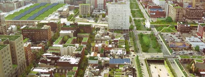
5 Participatory Modeling Case Study Green City, Clean Waters Green Infrastructure Study agent-based model conceptual designs
6 Data Collection/Generation Participant-observation 20-month period > 30 meetings & events Purposive Sampling Questionnaires 70 residents preferences, concerns, and interest GI Interviews 13 Semi-structured Countless Unstructured Purposive Sampling Community Street Fair Booth attended by > 40 local residents Policy Official Outreach 5 local agencies 1 local councilmember 1 state representative 2 state departments 1 regional agency


7 Data Collection/Generation (cont d) Community Meetings 2 meetings with almost 50 residents charettes, asset mapping, and other activities (e.g. brainstorming, voting, and ranking)


8 Data Collection/Generation (cont d) Community Meetings (cont d)

9 Modeling Yards, Parks, & Impervious Surfaces

10 Modeling (cont d) Vacant Lots and Buildings
")

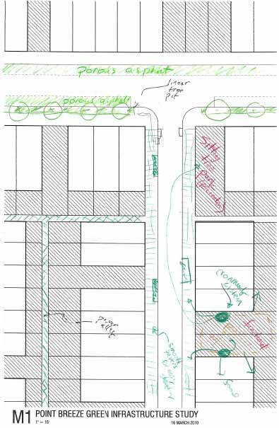
11 Modeling (cont d) Sample Block Modeling
 Decision Tree")

12 Modeling (cont d) Decision Tree SINGLE PARCEL DECISION TREE DETAIL
13 Iterative Process Data Generation Modeling Next Step?...Mediated Modeling with Community
14 Theoretical Framework Environmental Political Theory Environmental Modeling Debate & Discussion Theories of Deliberative Democracy & Deliberative Policy Analysis Preference Revision Legitimacy of Outcomes/ Justification to all Affected Participatory Modeling (Companion Modeling/ Mediated Modeling/ Collaborative Modeling) Collaborative Stakeholder Modeling Informed Process Scenarios Enhance Understanding & Facilitate Decision- Making
15 Points where principles converge Involvement at all stages Problem identification Knowledge Scientific information, local knowledge, values Learning Iterative process Context-dependent Adaptive/Flexible process Reflexive No a priori hypotheses
16 Synergy with Neighborhood Improvement Goals: Which of these neighborhood improvement goals do you think could be benefitted by a Green Infrastructure Program? 100% (Percentage out of 66 residents who completed the questionnaire) 90% 80% 70% 60% 50% 40% 30% 20% 10% 0%
17 Green Infrastructure Preferences: Which of the following examples of green infrastructure approaches do you see as best suited for your neighborhood? (Percentage out of 66 residents who completed the questionnaire) 100% 90% 80% 70% 60% 50% 40% 30% 20% 10% 0% Rain Barrels, or Rainwater Harvesting/Urban Agriculture Permeable Pavements Street Trees, or Stormwater Tree Pits Rain Gardens (in yards, sidewalks, or underutilized public spaces)

18


19
20 Challenges: Methodological Methodological Presuppositions Data & Methods Legitimacy

21 Challenges: Methodological (cont d) Points where principles may conflict Communicative Rationality Authentic Deliberation Instrumental Rationality Representative Democracy engaging the public in discursive action the strategic pursuit of goals and interests
22 Challenges: Methodological (cont d) Quantifying and statistically analyzing social factors Will voices get muted in the process? Will power relations get obscured? A priori assumptions Impacts of Inclusion and Exclusion

23 Challenges: Meaningful Participatory Process Time & Money Representation Involvement at all stages Responsibility without authority Politics Model as a black box
24 Challenges: Meaningful Participatory Process (cont d) Neighborhood Concerns poverty, crime, unemployment Collaboration Concerns intra-community collaboration government-community collaboration

25 Policy Implications Macro- vs. Micro-Deliberative Processes Complexity & Uncertainty Process over Outcome
26 Policy & Practical Implications Deliberative Principles Policy Practice 1. Recognition and Acknowledgement of Different Meanings 2. Deeper Understanding of Differences 3. Recognize and Foster Agreement
27 Participatory Modeling Case Study Participatory Modeling Uncertainty & Complexity Understanding Decision-Making
28 For more on participatory modeling Session 43 City Planning II Managing uncertainty and complexity in the development of a green infrastructure program through stakeholder participation: participatory agent based modeling and simulation of green infrastructure emergence in Point Breeze Franco Montalto, Drexel University 1:45 pm


29 Thank You! Questions?
Proposed Scope of Work Village of Farmingdale Downtown Farmingdale BOA Step 2 BOA Nomination Study / Draft Generic Environmental Impact Statement
 Proposed Scope of Work Village of Farmingdale Downtown Farmingdale BOA Step 2 BOA Nomination Study / Draft Generic Environmental Impact Statement The scope of work that follows incorporates and covers
Urban Climate Resilience
 Urban Climate Resilience in Southeast Asia Partnership Project Introduction Planning for climate change is a daunting challenge for governments in the Mekong Region. Limited capacity at the municipal level,
Scenario development for reaching urban and environmental planning integration in the context of climate change*.
 Scenario development for reaching urban and environmental planning integration in the context of climate change*. PhD (cand) Verónica Zagare (TUDelft, ) Dr. Diego Sepúlveda Carmona (TUDelft) September
GOVERNMENT MAPPING WORKSHOP RECOVER Edmonton s Urban Wellness Plan Mapping Workshop December 4, 2017
 GOVERNMENT MAPPING WORKSHOP 12.4.17 RECOVER Edmonton s Urban Wellness Plan Mapping Workshop December 4, 2017 In July of 2017, City Council directed administration to develop RECOVER, Edmonton s Urban Wellness
SPLAN-Natura Towards an integrated spatial planning approach for Natura th January, 2017 Brussels. Commissioned by DG Environment
 SPLAN-Natura 2000 Towards an integrated spatial planning approach for Natura 2000 Commissioned by DG Environment 17 th January, 2017 Brussels V. Simeonova (Ph.D.) Drivers towards integrating Biodiversity
TOWARDS A JUST CITY JAVIER MARTINEZ. URBAN STUDIES SYMPOSIUM: URBANIZATION FUTURES June
 TOWARDS A JUST CITY JAVIER MARTINEZ URBAN STUDIES SYMPOSIUM: URBANIZATION FUTURES June 14 2018 THE JUST CITY - BACKGROUND 1970s mainstream in planing was stimulating growth and the functional city The
ACTION PLAN FOR WORLD HERITAGE IN LATIN AMERICA AND THE CARIBBEAN ( )
") Annex ACTION PLAN FOR WORLD HERITAGE IN LATIN AMERICA AND THE CARIBBEAN (2014-2024) The current Regional Action Plan for Latin America and the Caribbean for 2014-2024 has been elaborated by the State Parties
Annex ACTION PLAN FOR WORLD HERITAGE IN LATIN AMERICA AND THE CARIBBEAN (2014-2024) The current Regional Action Plan for Latin America and the Caribbean for 2014-2024 has been elaborated by the State Parties
Applying Health Outcome Data to Improve Health Equity
 Applying Health Outcome Data to Improve Health Equity Devon Williford, MPH, Health GIS Specialist Lorraine Dixon-Jones, Policy Analyst CDPHE Health Equity and Environmental Justice Collaborative Mile High
Council Workshop on Neighbourhoods Thursday, October 4 th, :00 to 4:00 p.m. Burlington Performing Arts Centre
 Council Workshop on Neighbourhoods Thursday, October 4 th, 2012 1:00 to 4:00 p.m. Burlington Performing Arts Centre Agenda Introductions Warm-Up Exercise Presentation Exercise Neighbourhood Planning Break
Economic and Social Council
 United Nations Economic and Social Council Distr.: General 18 July 2016 Original: English Committee of Experts on Global Geospatial Information Management Sixth session New York, 3-5 August 2016 Item 2
The role of community in urban regeneration: mixed use areas approach in USA
 The role of community in urban regeneration: mixed use areas approach in USA Outline 1. Thesis 2. Main topics 3. Urban regeneration and community 4. Community involvement methods 5. Policies: EU vs USA
Outline National legislative & policy context Regional history with ESSIM ESSIM Evaluation Phase Government Integration via RCCOM Regional ICOM Framew
 What MSP Implementation could change in the Maritimes Region Tim Hall, Regional Manager Oceans and Coastal Management Division Ecosystem Management Branch Fisheries and Oceans Canada Maritimes Region BIO
Economic and Social Council
 United Nation E/C.20/2012/4/Add.1 Economic and Social Council Distr.: General 2 July 2012 Original: English Committee of Experts on Global Geospatial Information Management Second session New York, 13-15
TP4D. Fostering territorial perspective for development. Towards a wider alliance
 Fostering territorial perspective for development Towards a wider alliance FOR several years, territorial approaches to development have been spreading within international organizations and among development
SPIMA Spatial dynamics and strategic planning in metropolitan areas
 Targeted Analysis SPIMA Spatial dynamics and strategic planning in metropolitan areas Executive Summary Conference version 1 February 2018 0 1. Background To address the challenges of metropolitan development
Place Branding and Strategic Spatial Planning: Towards a conceptual model to brand regions
 Place Branding and Strategic Spatial Planning: Towards a conceptual model to brand regions Eduardo Oliveira Department of Spatial Planning and Environment, Faculty of Spatial Sciences University of Groningen,
Natura 2000 and spatial planning. Executive summary
 Natura 2000 and spatial planning Executive summary DISCLAIMER The information and views set out in this study are those of the author(s) and do not necessarily reflect the official opinion of the Commission.
KUNMING FORUM ON UNITED NATIONS GLOBAL GEOSPATIAL INFORMATION MANAGEMENT CITIES OF THE FUTURE: SMART, RESILIENT
 KUNMING FORUM ON UNITED NATIONS GLOBAL GEOSPATIAL INFORMATION MANAGEMENT CITIES OF THE FUTURE: SMART, RESILIENT and SUSTAINABLE Yunnan Zhenzhuang Guest House, Kunming, China 10 12 May 2017 BACKGROUND CONCEPT
Towards international cooperation in the development of Marine Spatial Plans for the North Pacific: economic, social, and environmental dimensions
 Towards international cooperation in the development of Marine Spatial Plans for the North Pacific: economic, social, and environmental dimensions A.V. Sereda, V.B. Lobanov V.I. Il ichev Pacific Oceanological
GIS AND COMMUNITY ENGAGEMENT: SOCIOSPATIAL APPROACHES TO RESEARCH AND POLICY
 GIS AND COMMUNITY ENGAGEMENT: SOCIOSPATIAL APPROACHES TO RESEARCH AND POLICY DR. SHEILA LAKSHMI STEINBERG BRANDMAN UNIVERSITY CHAPMAN UNIVERSITY SYSTEM GIS DAY PRESENTATION-UNIVERSITY OF KANSAS, NOVEMBER
RURAL-URBAN PARTNERSHIPS: AN INTEGRATED APPROACH TO ECONOMIC DEVELOPMENT
 RURAL-URBAN PARTNERSHIPS: AN INTEGRATED APPROACH TO ECONOMIC DEVELOPMENT William Tompson Head of the Urban Development Programme OECD Public Governance and Territorial Development Directorate JAHRESTAGUNG
GENERAL RECOMMENDATIONS. Session 7. Breakout discussion. discuss on regional and interregional. proposals 1. COLLABORATION BETWEEN PROGRAMMES
 Session 7 24 July 2016, 9.00-11.00 Breakout discussion on regional and interregional joint project proposals Mr Shahbaz Khan summarized the two days of presentations and exchanges and requested the participants
Implementing the Sustainable Development Goals: The Role of Geospatial Technology and Innovation
 Fifth High Level Forum on UN Global Geospatial Information Management Implementing the Sustainable Development Goals: The Role of Geospatial Technology and Innovation 28-30 November 2017 Sheraton Maria
Land Cover Classification Mapping & its uses for Planning
 Land Cover Classification Mapping & its uses for Planning What is Land Cover Classification Mapping? Examples of an actual product Why use Land Cover Classification Mapping for planning? Possible uses
Sustainable tourism in for Sustaibale Danang
 Sustainable tourism in for Sustaibale Danang A case study of Balearic Ecotax in Spain toward Sustainable tourism Miki Yoshizumi Associate Professor College of Gastronomy Management Ritsumeikan University
Statement. H.E. Mr. Gyan Chandra Acharya
 As delivered Statement by H.E. Mr. Gyan Chandra Acharya Under-Secretary-General and High Representative for the Least Developed Countries, Landlocked Developing Countries and Small Island Developing States
Overcoming Complexities on the Interface of Infrastructure and Land Use
 Date 22-11-2013 1 Overcoming Complexities on the Interface of Infrastructure and Land Use Towards design preconditions for integrated regional development Niels Heeres & Jos Arts University of Groningen,
REGIONAL SDI DEVELOPMENT
 REGIONAL SDI DEVELOPMENT Abbas Rajabifard 1 and Ian P. Williamson 2 1 Deputy Director and Senior Research Fellow Email: abbas.r@unimelb.edu.au 2 Director, Professor of Surveying and Land Information, Email:
The Road to Data in Baltimore
 Creating a parcel level database from high resolution imagery By Austin Troy and Weiqi Zhou University of Vermont, Rubenstein School of Natural Resources State and local planning agencies are increasingly
Indicator : Average share of the built-up area of cities that is open space for public use for all, by sex, age and persons with disabilities
 Goal 11: Make cities and human settlements inclusive, safe, resilient and sustainable Target 11.7: By 2030, provide universal access to safe, inclusive and accessible, green and public spaces, in particular
Arctic Spatial Data Infrastructure Enabling Access to Arctic Location-Based Information
 Arctic Spatial Data Infrastructure Enabling Access to Arctic Location-Based Information Arctic SDI Side Event Co-Chairs: Arvo Kokkonen Arctic SDI Board Chair & Director General, National Land Survey of
City of Jerez Urban Core Densification proposal; An Agent Based Spatio-temporal model
 Modelling urban population allocation City of Jerez Urban Core Densification proposal; An Agent Based Spatio-temporal model Elke Sauter Julia Úbeda Who we are & why we are here Masters programme: Geographical
A Framework for Incorporating Community Benefits Agreements into. 14 July
 A Framework for Incorporating Community Benefits Agreements into Brownfield Redevelopm ent Projects: The Case of Chelsea, Massachusetts I. Introduction to the Project 2010 ESRI User Conference 14 July
Cultural Data in Planning and Economic Development. Chris Dwyer, RMC Research Sponsor: Rockefeller Foundation
 Cultural Data in Planning and Economic Development Chris Dwyer, RMC Research Sponsor: Rockefeller Foundation A Decade of Attempts to Quantify Arts and Culture Economic impact studies Community indicators
GIS AND GEOSPATIAL INFORMATION MANAGEMENT FOR URBAN PLANNING AND LAND MANAGEMENT IN SAUDI ARABIA
 GIS AND GEOSPATIAL INFORMATION MANAGEMENT FOR URBAN PLANNING AND LAND MANAGEMENT IN SAUDI ARABIA Manal Al-Hajji GIS Consultant Oman Geospatial Forum Oman April 10-11, 2017 CONTENTS 1. Future Saudi Cities
The Underutilization of GIS & How to Cure It. Adam Carnow Esri
 The Underutilization of GIS & How to Cure It Adam Carnow Esri What is GIS? A framework to organize, communicate, and understand the science of our world Business Intelligence (BI) is the set of
RETA 6422: Mainstreaming Environment for Poverty Reduction Category 2 Subproject
 RETA 6422: Mainstreaming Environment for Poverty Reduction Category 2 Subproject A. Basic Data 1. Subproject Title: Poverty-Environment Mapping to Support Decision Making 2. Country Director: Adrian Ruthenberg
2018/1 The integration of statistical and geospatial information. The Regional Committee of UN-GGIM: Americas:
 The following are the conclusions and recommendations of the Regional Committee of the United Nations on Global Geospatial Information Management for the Americas, during its Fifth Session, Thursday 8
Chisoni Mumba. Presentation made at the Zambia Science Conference 2017-Reseachers Symposium, th November 2017, AVANI, Livingstone, Zambia
 Application of system dynamics and participatory spatial group model building in animal health: A case study of East Coast Fever interventions in Lundazi and Monze districts of Zambia Chisoni Mumba Presentation
What is Spatial Planning?
 Spatial Planning in the context of the Responsible Governance of Tenure What is Spatial Planning? Text-only version This course is funded by the European Union through the EU-FAO Improved Global Governance
Briefing. H.E. Mr. Gyan Chandra Acharya
 Briefing by H.E. Mr. Gyan Chandra Acharya Under-Secretary-General and High Representative for the Least Developed Countries, Landlocked Developing Countries and Small Island Developing States Briefing
Utilizing GIS as a Critical Campus. Karen Jordan February 24, 2011
 Utilizing GIS as a Critical Campus Resource Karen Jordan February 24, 2011 Agenda Campus Background Opportunity for a Campus-wide GIS Data Structure and Collection How Has GIS Been Utilized on Campus Over
Marine Spatial Planning Leslie-Ann McGee Battelle Memorial Institute
 Marine Spatial Planning Leslie-Ann McGee Battelle Memorial Institute Rev061708 1 Marine Spatial Planning What is it? Why is it different? Where is it currently being employed? What is happening in the
Presented by: Bryan Bloch GIS Specialist DNREC Division of Watershed Stewardship
 Presented by: Bryan Bloch GIS Specialist DNREC Division of Watershed Stewardship Bryan Hall, AICP Sussex County Circuit Rider Planner, Office of State Planning Coordination, OMB November 19, 2012 UD Sustainable
Shaping Your Neighbourhood
 Shaping Your Neighbourhood Building a Core Sustainable Neighbourhood Action Plan Nov. 25 & 26, 2006 Welcome! Peter Russell Planner, Holland Barrs Planning Group Inc. Role in this project: Work with the
Decision Theory. What is it? Alexei A. Borissov February 1, 2007
 Decision Theory What is it? Alexei A. Borissov February 1, 2007 Agenda Background History Bayes Theorem Example of Bayes Theorem Expected Utility Expected Utility Example Further Research Conclusion Background
The World Bank Mali Reconstruction and Economic Recovery (P144442)
") Public Disclosure Authorized AFRICA Mali Social, Urban, Rural and Resilience Global Practice Global Practice IBRD/IDA Investment Project Financing FY 2014 Seq No: 8 ARCHIVED on 19-Dec-2017 ISR30326 Implementing
Public Disclosure Authorized AFRICA Mali Social, Urban, Rural and Resilience Global Practice Global Practice IBRD/IDA Investment Project Financing FY 2014 Seq No: 8 ARCHIVED on 19-Dec-2017 ISR30326 Implementing
Smart City Governance for effective urban governance. David Ludlow Assoc. Professor European Smart Cities University of the West of England, Bristol
 Smart City Governance for effective urban governance David Ludlow Assoc. Professor European Smart Cities University of the West of England, Bristol Complexities of urban territorial governance Complexities
DRAFT CONCEPT NOTE. WDR 2008: Agriculture for Development WDR 2007: Development and the Next Generation WDR 2006: Equity and Development
 WORLD DEVELOPMENT REPORT, WDR 2009 RESHAPING ECONOMIC GEOGRAPHY CONSULTATION - MENA REGION MAY 5-6, 2008 DRAFT CONCEPT NOTE The World Bank publishes each year a World Development Report (WDR) focusing
The World Bank Mali Reconstruction and Economic Recovery (P144442)
") Public Disclosure Authorized AFRICA Mali Social, Urban, Rural and Resilience Global Practice Global Practice IBRD/IDA Emergency Recovery Loan FY 2014 Seq No: 7 ARCHIVED on 30-Jun-2017 ISR28723 Implementing
Public Disclosure Authorized AFRICA Mali Social, Urban, Rural and Resilience Global Practice Global Practice IBRD/IDA Emergency Recovery Loan FY 2014 Seq No: 7 ARCHIVED on 30-Jun-2017 ISR28723 Implementing
Call for papers: "Modelling complex urban environments" specialist conference Sponsored by the Waterloo Institute for Complexity & Innovation (WICI)
") Call for papers: "Modelling complex urban environments" specialist conference Sponsored by the Waterloo Institute for Complexity & Innovation (WICI) June 21-22, 2018, St. Jerome s College, University of
Call for papers: "Modelling complex urban environments" specialist conference Sponsored by the Waterloo Institute for Complexity & Innovation (WICI) June 21-22, 2018, St. Jerome s College, University of
Minnesota Transportation Museum
 Minnesota Transportation Museum Minnesota Social Studies s Alignment Second Grade 1 Code Benchmark 1. Citizenship and Government 1. Civic Skills. Civic Values and Principles of Democracy 4. Governmental
November 29, World Urban Forum 6. Prosperity of Cities: Balancing Ecology, Economy and Equity. Concept Note
 November 29, 2010 World Urban Forum 6 Prosperity of Cities: Balancing Ecology, Economy and Equity Concept Note 1 CONTENT Thematic Continuity Conceptualizing the Theme The 6 Domains of Prosperity The WUF
Space Syntax: Architecture and Cities MRes This programme information sheet includes details of the structure and content of the course.
 Space Syntax: Architecture and Cities MRes 2018-19 This programme information sheet includes details of the structure and content of the course. CONTENTS Overview 3 Structure 4 Content 5 Staff 6 Opportunities
Thilo Becker
 Friedrich List Faculty of Transport and Traffic Science, Chair of Transport Ecology CAN THE CONCEPT OF ENVIRONMENTAL JUSTICE IN TRANSPORT BE TRANSFERRED TO CITIES OF THE SOUTH? A CASE STUDY OF NAIROBI
International Guidelines on Access to Basic Services for All
 International Guidelines on Access to Basic Services for All Presentation and initials lessons from implementation Accessibility to services in regions and cities : measures and policies, OECD 18 June
Community Engagement in Cultural Routes SiTI Higher Institute on Territorial Systems for Innovation Sara Levi Sacerdotti
 Transnational Workshop Wroclaw, 7th-8th December 2016 Community Engagement in Cultural Routes SiTI Higher Institute on Territorial Systems for Innovation Sara Levi Sacerdotti levi@siti.polito.it TAKING
An introduction to thee Urban Oases Site Selection Tool:
 An introduction to thee Urban Oases Site Selection Tool: Created by Audubon Connecticut with assistance from a GIS Consultant/Research Assistant at the Harvard Forest Essential input provided by the New
GIS for Planning and Revenue Collection
 GIS for Planning and Revenue Collection Laban Karanja & Barbara Seje GIS for County Government Seminar Agenda Introduction County goals County Challenges GIS as a solution for County challenges What Counties
GIS Capability Maturity Assessment: How is Your Organization Doing?
 GIS Capability Maturity Assessment: How is Your Organization Doing? Presented by: Bill Johnstone Principal Consultant Spatial Vision Group November 8, 2018 1. Motivation for Capability Maturity Models
Access to Parks for Youth as an Environmental Justice Issue: Access Inequalities and Possible Solutions
 Buildings 2014, 4, 69-94; doi:10.3390/buildings4020069 Article OPEN ACCESS buildings ISSN 2075-5309 www.mdpi.com/journal/buildings/ Access to Parks for Youth as an Environmental Justice Issue: Access Inequalities
Statement of Mr. Sandagdorj Erdenebileg, Chief, Policy Development, Coordination, Monitoring and Reporting Service, UN-OHRLLS.
 Statement of Mr. Sandagdorj Erdenebileg, Chief, Policy Development, Coordination, Monitoring and Reporting Service, UN-OHRLLS at the Botswana National Workshop on the Vienna Programme of Action 27 th October
Challenges of Urbanisation & Globalisation
 Challenges of Urbanisation & Globalisation Prepared by: Khairul Hisyam Kamarudin, PhD Feb 2016 Based on original lecture note by: Wan Nurul Mardiah Wan Mohd Rani, PhD URBANIZATION What is Urbanization?
LAND USE PLANNING (LUP) TOOLS A bottom-up tool
 TOOLS A bottom-up tool") LAND USE PLANNING (LUP) TOOLS A bottom-up tool PARTICIPATORY 3D MAPPING IN THE UPPER SURINAME RIVER BASIN A tool for an inclusive land use planning and decision making in Suriname. Sara O.I. Ramirez Gomez
LAND USE PLANNING (LUP) TOOLS A bottom-up tool PARTICIPATORY 3D MAPPING IN THE UPPER SURINAME RIVER BASIN A tool for an inclusive land use planning and decision making in Suriname. Sara O.I. Ramirez Gomez
Urban Inclusiveness In Theory and (Global Policy) Practice. Tim Bunnell Department of Geography National University of Singapore
 Practice. Tim Bunnell Department of Geography National University of Singapore") Urban Inclusiveness In Theory and (Global Policy) Practice Tim Bunnell Department of Geography National University of Singapore geotgb@nus.edu.sg Urban Inclusiveness In Theory and (Global Policy) Practice
Urban Inclusiveness In Theory and (Global Policy) Practice Tim Bunnell Department of Geography National University of Singapore geotgb@nus.edu.sg Urban Inclusiveness In Theory and (Global Policy) Practice
City and SUMP of Ravenna
 City and SUMP of Ravenna Nicola Scanferla Head of Mobility Planning Unit, Municipality of Ravenna nscanferla@comune.ra.it place your logo here 19 April, 2017 1st Steering Committee Meeting, Nicosia, Cyprus
What s wrong with sprawl? The urgent need for cost benefit analyses of modern urban growth patterns. Jacy Gaige
 What s wrong with sprawl? The urgent need for cost benefit analyses of modern urban growth patterns. Jacy Gaige Urban Econ 245 Professor Charles Becker Literature Review 1 Urban is hip. Bikes, messenger
Regulating Nanotechnologies in the EU and US: Towards Effectiveness and Convergence
 the EU and US: Towards Effectiveness and Convergence Project Consortium: London School of Economics (LSE) Chatham House Environmental Law Institute (ELI) Project on Emerging Nanotechnologies (PEN) Project
Key Points Sharing fosters participation and collaboration Metadata has a big role in sharing Sharing is not always easy
 Sharing Resources Geoff Mortson esri, Inc. SDI Solutions Team Key Points Sharing fosters participation and collaboration Metadata has a big role in sharing Sharing is not always easy Data Sharing is Good
Sri Lanka Strategic Cities Development Project (P130548)
") SOUTH ASIA Sri Lanka Social, Urban, Rural and Resilience Global Practice Global Practice IBRD/IDA Investment Project Financing FY 2014 Seq No: 10 ARCHIVED on 21-Dec-2018 ISR35436 Implementing Agencies:
SOUTH ASIA Sri Lanka Social, Urban, Rural and Resilience Global Practice Global Practice IBRD/IDA Investment Project Financing FY 2014 Seq No: 10 ARCHIVED on 21-Dec-2018 ISR35436 Implementing Agencies:
The World Bank. Key Dates. Project Development Objectives. Components. Overall Ratings. Public Disclosure Authorized
 Public Disclosure Authorized Public Disclosure Copy AFRICA South Sudan Urban Development Global Practice IBRD/IDA Specific Investment Loan FY 2013 Seq No: 4 ARCHIVED on 11-Feb-2015 ISR18127 Implementing
Optimization of Use of Vacant Land for Urban Agriculture in the Municipality of Rosario, Argentina
 Optimization of Use of Vacant Land for Urban Agriculture in the Municipality of Rosario, Argentina Summary prepared by Marielle Dubbeling (PIES/PGU-ALC) based on project documents elaborated by Elio Di
USEPA's Comprehensive Geospatial Information Sharing Framework
 USEPA's Comprehensive Geospatial Information Sharing Framework An Overview ESRI Federal User Conference February 22, 2008 Agenda Background What is EPA s Geospatial Information Sharing Framework? Why was
ArcGIS for Local Government. Local Government. Title Placed Here
 ArcGIS for ArcGIS for Local Government Local Government Title Placed Here ArcGIS for Local Government solutions.arcgis.com/local-government Copyright 2016 Esri. All rights reserved. 151760 G73000 Address
A Preliminary Model of Community-based Integrated Information System for Urban Spatial Development
 A Preliminary Model of Community-based Integrated Information System for Urban Spatial Development Bauni HAMID 1, Devin DEFRIZA 2 1 2 CAITAD (Center of Applied Information Technology in Planning and Design),
FIG Asia Pacific Capacity Development Network
 FIG Asia Pacific Capacity Development Network Report to the 41th General Assembly FIG Congress 2018, Istanbul - Turkey Rob Sarib Chair FIG Asia Pacific Capacity Development Network (AP CDN) Story of the
Linking Neighbourhood Data in the Analysis of Crime
 Linking Neighbourhood Data in the Analysis of Crime Professor Susan McVie University of Edinburgh CEBCP-SIPR Joint Symposium 8 th April 2013 The importance of crime mapping for policing in UK Understanding
The FIG - Questionnaire on NSDI
 The FIG - Questionnaire on NSDI Bernd Teichert University of Applied Sciences Dresden, Germany Contents NSDI - Definition Com. 3 - Brainstorming in Prague Canberra Implications and Conclusions The SDI
Ministry of Health and Long-Term Care Geographic Information System (GIS) Strategy An Overview of the Strategy Implementation Plan November 2009
 Strategy An Overview of the Strategy Implementation Plan November 2009") Ministry of Health and Long-Term Care Geographic Information System (GIS) Strategy An Overview of the Strategy Implementation Plan November 2009 John Hill, Health Analytics Branch Health System Information
Ministry of Health and Long-Term Care Geographic Information System (GIS) Strategy An Overview of the Strategy Implementation Plan November 2009 John Hill, Health Analytics Branch Health System Information
MANAGING TRANSPORTATION & LAND USE INTERACTIONS (PL-58)
") MANAGING TRANSPORTATION & LAND USE INTERACTIONS (PL-58) COURSE OUTLINE DAY ONE 1:30 2:00 p.m. MODULE 1: History and Context Understand history and foundation for transportation and land use planning today
MANAGING TRANSPORTATION & LAND USE INTERACTIONS (PL-58) COURSE OUTLINE DAY ONE 1:30 2:00 p.m. MODULE 1: History and Context Understand history and foundation for transportation and land use planning today
Recovery Renewal Rebuilding
 Recovery Renewal Rebuilding Federal Reserve Foreclosure Series Washington, D.C. October 20, 2008 Mayor Jay Williams, Youngstown OH The City of Youngstown Youngstown State University Urban Strategies Inc.
Economic and Social Council
 United Nations Economic and Social Council Distr.: General 2 July 2012 E/C.20/2012/10/Add.1 Original: English Committee of Experts on Global Geospatial Information Management Second session New York, 13-15
European Journal of Multidisciplinary Studies
 Identifying the Influential Factors on Social Impact Assessment of Reconstruction Projects in Historic Site - A Case Study on Jameh Mosque Street, Yazd, Iran Mohammad Nasir Tighsazzadeh Department of Urban
UN-GGIM: Strengthening Geospatial Capability
 Fifth Plenary Meeting of UN-GGIM: Europe Brussels, 6-7 June 2018 UN-GGIM: Strengthening Geospatial Capability Walking the talk to leave no one behind Greg Scott, UN-GGIM Secretariat Environmental Statistics
New Partners for Smart Growth: Building Safe, Healthy, and Livable Communities Mayor Jay Williams, Youngstown OH
 New Partners for Smart Growth: Building Safe, Healthy, and Livable Communities Mayor Jay Williams, Youngstown OH The City of Youngstown Youngstown State University Urban Strategies Inc. Youngstown needed
Unmanned Aerial Systems (UAS) Innovation for affordable, improved and accelerated spatial data acquisition
 Innovation for affordable, improved and accelerated spatial data acquisition") Unmanned Aerial Systems (UAS) Innovation for affordable, improved and accelerated spatial data acquisition Kathrine Kelm, The World Bank Rumyana Tonchovska, FAO Walter Volkmann, Micro Aerial Projects,
Unmanned Aerial Systems (UAS) Innovation for affordable, improved and accelerated spatial data acquisition Kathrine Kelm, The World Bank Rumyana Tonchovska, FAO Walter Volkmann, Micro Aerial Projects,
Webinar in Preparation for Nature and Culture Summit and COP 14 of the Convention on Biological Diversity
 Webinar in Preparation for Nature and Culture Summit and COP 14 of the Convention on Biological Diversity https://www.cbd.int/tk/nature.shtml English Session November 6th, 10:30-11:30 EST Agenda 1. Introduction
Cities, AI, Design, & the Future Can Artificial Intelligence Improve Design Intelligence?
 March 27 th 28 Cities, AI, Design, & the Future Can Artificial Intelligence Improve Design Intelligence? Michael Batty m.batty@ucl.ac.uk @jmichaelbatty http://www.spatialcomplexcity.info/ http://www.casa.ucl.ac.uk/
CRP 608 Winter 10 Class presentation February 04, Senior Research Associate Kirwan Institute for the Study of Race and Ethnicity
 CRP 608 Winter 10 Class presentation February 04, 2010 SAMIR GAMBHIR SAMIR GAMBHIR Senior Research Associate Kirwan Institute for the Study of Race and Ethnicity Background Kirwan Institute Our work Using
CONCEPT NOTE. UNESCO s International Science School 29 May - 1 June 2018, Havana, Cuba
 CONCEPT NOTE UNESCO s International Science School 29 May - 1 June 2018, Havana, Cuba Building resilient societies through the links between research, disaster risk reduction and climate change adaptation
I Background. Under the Cotton Tree: Situs Addressing System in Africa. Table of contents
 Cairo, April 2005 Under the Cotton Tree: Situs Addressing System in Africa Table of contents 1. Background 2. Current situation of addressing system in Africa 3. Benefits of a functional addressing system
Environmental Analysis, Chapter 4 Consequences, and Mitigation
 Environmental Analysis, Chapter 4 4.17 Environmental Justice This section summarizes the potential impacts described in Chapter 3, Transportation Impacts and Mitigation, and other sections of Chapter 4,
USER PARTICIPATION IN HOUSING REGENERATION PROJECTS
 USER PARTICIPATION IN HOUSING REGENERATION PROJECTS Dr. Hatice Sadıkoğlu Bahçeşehir University, Faculty of Architecture and Design Prof. Dr. Ahsen Özsoy Istanbul Technical University, Faculty of Architecture
ikapa GDS White Paper Governance and Integration Department of the Premier Department of the Premier 2 December 2008
 ikapa GDS White Paper Governance and Integration Outline of presentation Western Cape Situation Strategic Framework Implementation Framework Alignment and implementation example Diversified economy Small
Enabling Access to Arctic Location Based Information - the Arctic SDI
 Enabling Access to Arctic Location Based Information - the Arctic SDI Jani Kylmäaho Head of Arctic SDI Geoportal WG National Land Survey of Finland SAO Chair, WG Chairs and Executive Secretaries meeting
An online data and consulting resource of THE UNIVERSITY OF TOLEDO THE JACK FORD URBAN AFFAIRS CENTER
 An online data and consulting resource of THE JACK FORD URBAN AFFAIRS CENTER THE CENTER FOR GEOGRAPHIC INFORMATION SCIENCE AND APPLIED GEOGRAPHICS DEPARTMENT OF GEOGRAPHY AND PLANNING THE UNIVERSITY OF
Organizational Enablers for Project Governance
 Organizational Enablers for Project Governance PMI Oslo 2017 Ralf Müller, BI Norwegian Business School, PMI Fellow Email: ralf.muller@bi.no Agenda Background, concepts, definitions etc. Study aims and
CALOTS Upgrade for Performance Monitoring
 CALOTS Upgrade for Performance Monitoring A project of the Southern California Association of Governments supported by the UCLA Lewis Center for Regional Policy Studies Agenda 1. Revisit Project Overview
The World Bank Local and Regional Competitiveness Project (P154263)
") Public Disclosure Authorized EUROPE AND CENTRAL ASIA Macedonia, former Yugoslav Republic of Trade & Competitiveness Global Practice Recipient Executed Activities Investment Project Financing FY 2016 Seq
Public Disclosure Authorized EUROPE AND CENTRAL ASIA Macedonia, former Yugoslav Republic of Trade & Competitiveness Global Practice Recipient Executed Activities Investment Project Financing FY 2016 Seq
The Future of Tourism in Antarctica: Challenges for Sustainability
 The Future of Tourism in Antarctica: Challenges for Sustainability Machiel Lamers Thesis summary In the last decade, Antarctic tourism has grown rapidly both in terms of volume and diversity. This growth