GIS Serving today s technological demands. GIS in the Classroom. Opportunities and Challenges
|
|
|
- Meredith Flynn
- 5 years ago
- Views:
Transcription

1 GIS Serving today s technological demands GIS in the Classroom Opportunities and Challenges 1
2 A Challenge for Teachers (Your Challenge) To have Geography permeate all parts of the school curriculum
3 Why???? Geography pervades many aspects of our lives 80% of Decisions WHERE??
4 HOW?? An Information Technology: Geographic Information Systems
5 The Plan The pervasiveness of Geography Some idea of the technologies themselves Ideas of how you might incorporate technology in the curriculum and classroom The sorts of resources available to you Support networks


6 Climate and Our Environment Climatic Forecasts Global Irrigated & Rain Fed Cropland Sri Lanka Satellite Weather Mapping Weather Forecasting Korea Solar Analysis Los Angeles Air Pollution Rio de Janeiro Cloud Seeding Idaho


7 Natural Resource Management Timber Geologic Mapping USA Wild Fire Modeling Sub Surface Geology Ontario, Canada Forest/Land Cover Change California Groundwater South Africa 3-D Geologic Mapping Wyoming Exploring Oil Sands Alberta, Canada


8 Charting and Mapping Sea Floor Visualization Reference Map Nautical Charts Online Mapping National Geographic Maps Aeronautical Charts


9 Planning Master Plan Urban Design Massachusetts Land Use Planning Maryland Community Zoning Singapore Scenario Planning What if? Watershed Modeling Wyoming Suitability Analysis Idaho


10 Land Records Management Integrated Assessment Property Valuation Illinois Vertical Tax Appraisal Cadastral Data Management Sweden Integrating Old Maps Ireland Public Access LA County


11 Facility Management Water & Electricity Pasadena, California Water/Wastewater Germany Customers Electrical Outage Analysis Colorado Wireless Network Planning Lithuania Natural Gas Estonia Facility Inventory Facility Inventory Yakima, Washington


12 Natural and Human Disasters Train Accident Analyses Alabama High-impact impact Wind Areas Florida Nuclear Risk Analysis Korea Chemical Release Fire Los Angeles Hazards Mapping Fire Response Georgia Fire History San Diego Flood Modeling


13 Conservation and Environmental Restoration Archaeological Modeling Acacus Park, Libya Conservation San Francisco Salmon Habitat Modeling Washington Planning China Amazon Habitat Restoration Planning Optimal Bird Corridor Kenya


14 Transportation and Logistics Real-time Vehicle Tracking Transit Analysis California Airport Logistics Las Vegas Meter Reading Optimization Traffic Modeling Ride Share Ohio Traffic Estimation San Francisco Travel Planning AAA Trip Tik


15 Business Geographics Competitive Analysis North Carolina Flood Risk Midwest Retail Analysis Library/Museum Site Selection Post Office Optimization Insurance Germany


16 Human Health Smoking & Birth Weight Animal Influence in Humans HIV Cancer Social Indicators Dallas, Texas
17 THE MAP A GREAT COMMUNICATOR The intuitive power of maps reveals trends, patterns, and answers that are not as easily detected in other data presentation formats.
18 18
19 An Information System Spatial Data Management Spatial Data Analysis Visualisation Etc., Etc.,


20
21 GIS is part of Creating a New Approach... Improving How We Organize & Create Our Future
22 Our World Has Many Problems to Solve Growing Population Global Warming Social Conflicts Resource Shortages Loss of Biodiversity Security Population Density Land Cover UNEP We Need to Change We Need a New Approach We Need Greater Knowledge & Awareness Comprehensive Planning Efficiency & Sustainability Conservation of Nature Collaborative Action
23 The World Needs an Approach That Changes How We See Things Patterns And the Way We Do Things Relationships Our Understanding Implications Significance Consequences Nature Human Managing Deciding Designing Our Behavior Protecting Developing Regulating Restoring Helping
24 Geography Is the Science of Our World Helping Us See the World As a Living Whole As a Network Of Interrelated Systems And How We Are Part of Its Evolution... Providing a Context for Understanding
25 The Geographic Approach A Framework for Understanding and Managing Our Earth Creating Measuring Organizing Analyzing Modeling Geographic Knowledge Holistic Comprehensive Systematic Analytic Applying Visual Planning Designing Deciding Managing Acting Integrating Geography Into How We Behave
26 GIS Applies the Geographic Approach Providing Tools, Methods, and Workflows That Support Collaboration and Action Integration Measuring Storing Analyzing Work Flow Visualizing Spatial Analysis Collaboration Acting Better Decisions Greater Efficiency (Money/Time/Resources) More Effective Communication... Improving the Way We Do Things
27 GIS Is Being Used to Build Information Systems Supporting Many Workflows and Application Domains Business Analysis System Cartographic Information System Image Information System Cadastral Information System Facility Management System Information Systems for Natural Resources Land Use Planning Transportation Logistics Land Management Business Analysis Geospatial Intelligence Defense Visualization Scientific Analysis Public Safety Imagery Cartography Asset Management
28 The Web Provides a New Pattern for Implementing GIS Becoming a New Platform Supporting Collaborative Computing Service Integration (Mashups) User Contributed Content Distributed Data Management Map Services Distributed Collaboration GeoWeb Web 2.0 Many Participants Interconnected Interoperable Integrative Dynamic Web An Agile Framework for Collaboration & Integration of Systems
29 29
30 In the Curriculum and Classroom The challenge - Embed in courses and exercises Using the technology Learning the technology Using GIS IT A pervading technology not just geography Biology map plants and species History Mathematics Statistics Resources


31 National Geographic Map Machine

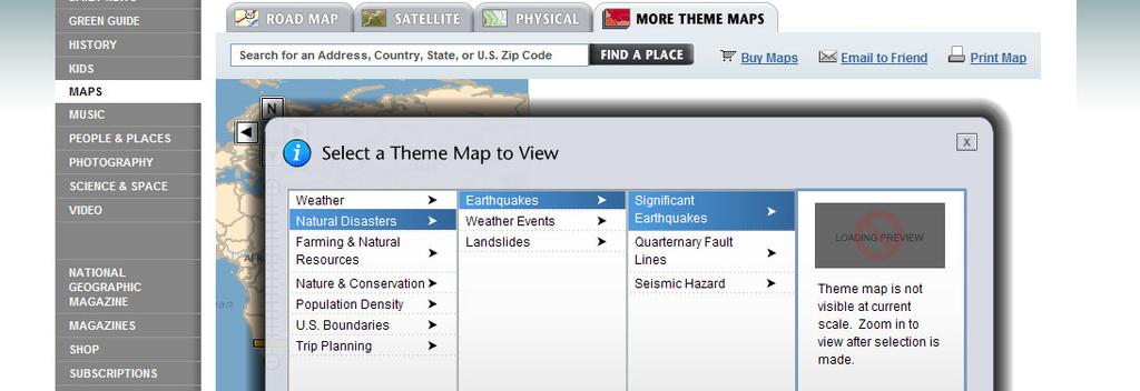
32 National Geographic Map Machine
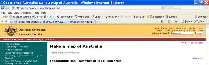

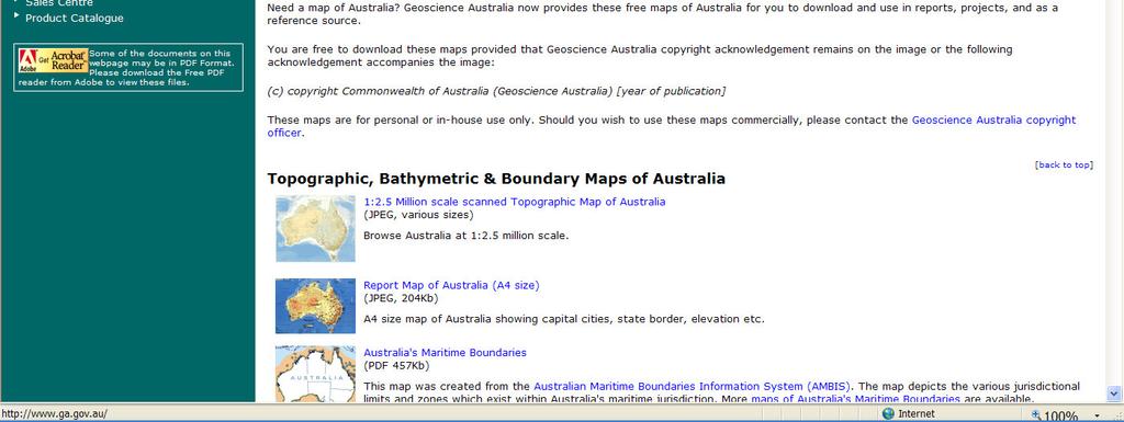
33 Geoscience Australia Making Maps

34 Geoscience Australia Making Maps

35 Geoscience Australia Making Maps
36
37
38


39 Geoscience Australia

40

41

42

43
44

45

46


47
48

49

50

51
52


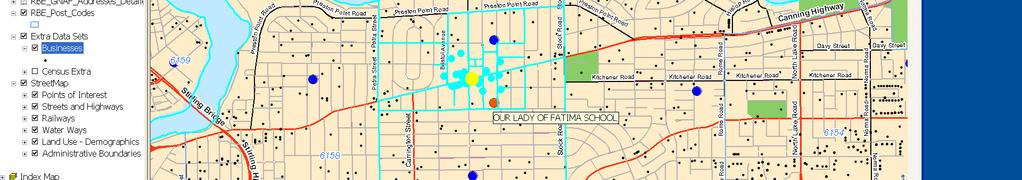
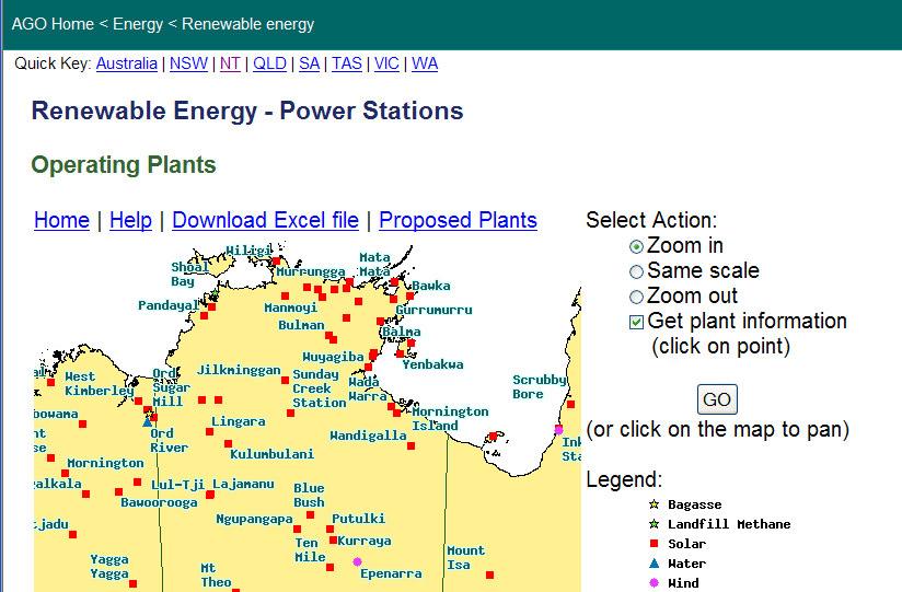
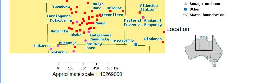
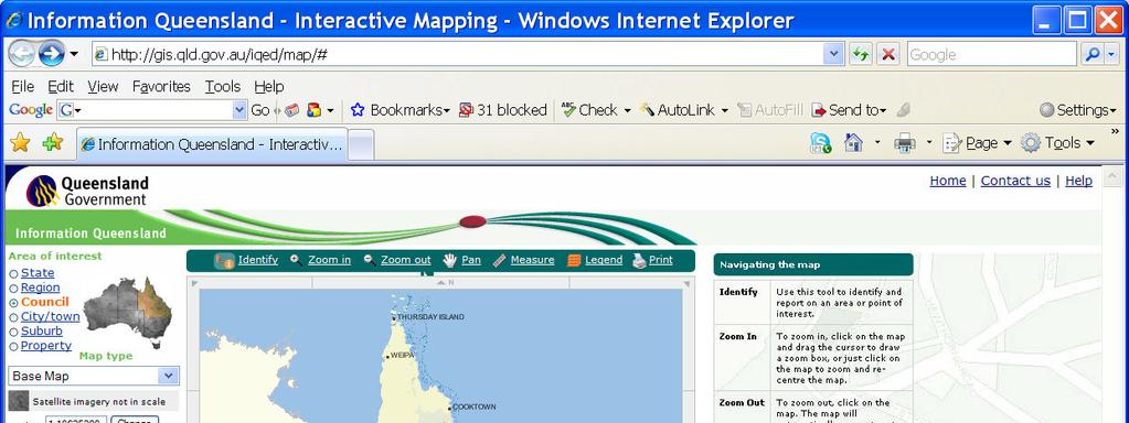
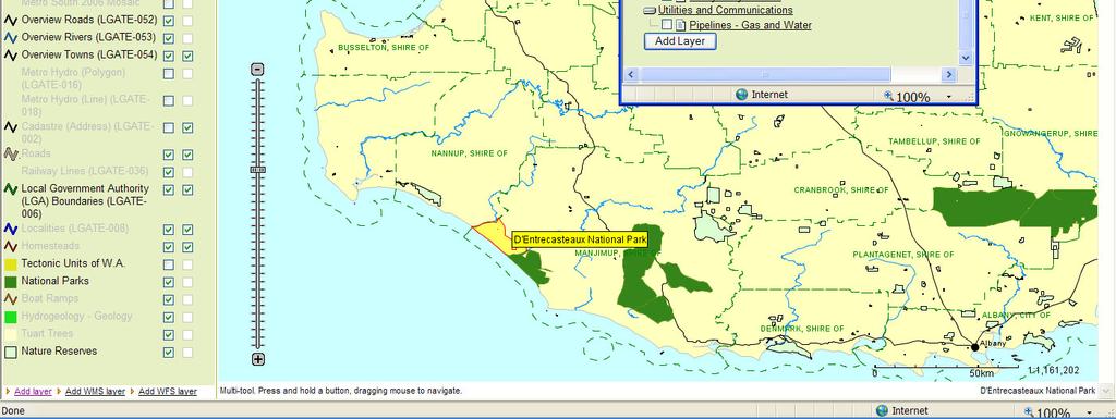
53 The role of Local Governments Web sites Data Exercises and Projects Community Mapping

54
55

56
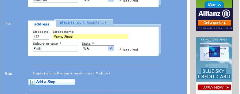
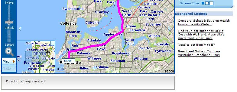
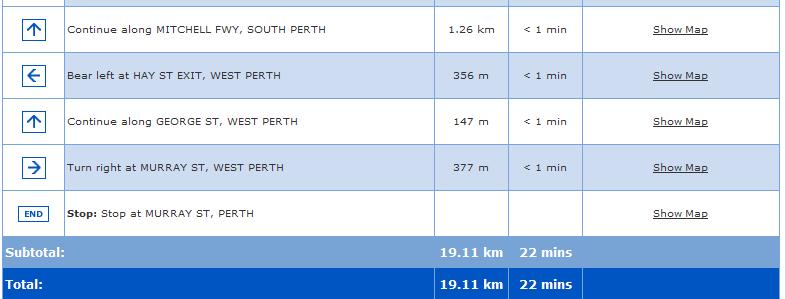
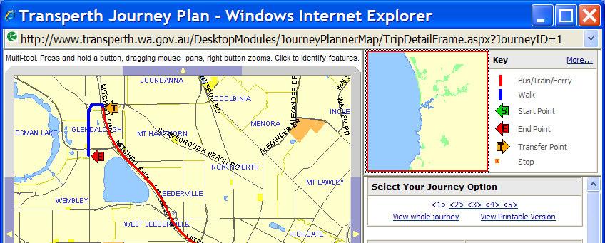
57 Take a Deep Breath!!! Some idea of GIS and its Pervasiveness Large number of resources to do: Geography and other disciplines through on-line maps Static Interactive Projects involving spatial data both On the net Locally by downloading data (depends on local GIS s ware) Look now at more interactive situations (inot general education and skills)


58 Whereis


59 Whereis

60 Whereis

61 Whereis

62 Whereis

63 Whereis


64 Transperth Journey Planner

65 Transperth Journey Planner

66

67


68 Google Story and search
69


70

71


72 BLOGS web sites for commentary


73 BLOGS web sites for commentary


74 BLOGS web sites for commentary


75 Street View what is the potential???


76 Street View what is the potential???
77 SSI - Spatial Technology in Schools


78 SSI - Spatial Technology in Schools

79


80 ESRI
81 Careers Application of GIS Multiple Disciplines Many and Varied Geologist to Engineer Health Scientist to Planner Information Management Architect, developer, database, analyst
82 Bachelor of Property & Sustainable Development Bachelor of Information Technology Bachelor of Urban Development (Spatial Science) Bachelor of Applied Science (Forestry) Bachelor of Commerce/Bachelor of Science Bachelor of Information Technology Associate Degree in Spatial Science Bachelor of Spatial Science Bachelor of Arts/Bachelor of Science (Planning and Environmental Science) Bachelor of Science (Environmental Science) Bond University - Gold Coast James Cook University - Townsville Queensland University of Technology - Gardens Point Southern Cross University - Lismore The University of Queensland - St Lucia The University of Queensland - St Lucia University of Southern Queensland - Toowoomba University of Southern Queensland - Toowoomba University of the Sunshine Coast - Sippy Downs University of the Sunshine Coast - Sippy Downs

83 Before closing some thoughts/actions Build on efforts of SSI Spatial Technology in Schools Develop a community of teachers interested in spatial Consider setting up an education blog Involve other disciplines Identify local community projects
84 In closing The potential pervasiveness of GIS Ideas of how you might incorporate technology in the curriculum and classroom The sorts of resources available to you Support networks The Challenge Can we use GIS to have Geography permeate all parts of the school curriculum??

85 Visualizing the Atmosphere Water Vapor Carbon Monoxide Ozone


86
ArcGIS for AutoCAD Esri International User Conference July 8 12, 2013 San Diego, California Technical Workshop
 2013 Esri International User Conference July 8 12, 2013 San Diego, California Technical Workshop ArcGIS for AutoCAD Karen Hodge, Lead Developer Don Kuehne, Product Manager ArcGIS for AutoCAD is Free Plug-In
Tools to Assess Local Health Needs. Richard Leadbeater, Esri NACo 2011 Healthy Counties Forum December 1, 2011
 Tools to Assess Local Health Needs Richard Leadbeater, Esri NACo 2011 Healthy Counties Forum December 1, 2011 Richard Leadbeater currently holds the position of Industry Solutions Manager with Esri. He
1The Many Uses of GIS
 1The Many Uses of GIS BUILDING EUROPEAN SPATIAL DATA INFRASTRUCTURES In April 2006, Esri president Jack Dangermond gave a presentation on the INSPIRE Directive at the European Union (EU) Interparliamentary
June 19 Huntsville, Alabama 1
 June 19 Huntsville, Alabama 1 Real-Time Geospatial Data: The Fusion of PI and ArcGIS Enabling Smarter Facilities Management OSIsoft and Esri Mapping and Location Analytics Platform Supporting Your Use
This Week is All About GIS, Geography and Sharing Our Knowledge
 Stockholm 2007 1 This Week is All About GIS, Geography and Sharing Our Knowledge Technology Methods Organization Data Processes Standards Projects Visualization And About You Applications Mapping Data
SUPPORTS SUSTAINABLE GROWTH
 DDSS BBUUN NDDLLEE G E O S P AT I A L G O V E R N A N C E P A C K A G E SUPPORTS SUSTAINABLE GROWTH www.digitalglobe.com BRISBANE, AUSTRALIA WORLDVIEW-3 30 CM International Civil Government Programs US
Welcome. C o n n e c t i n g
 Welcome C o n n e c t i n g YOU D i s c i p l i n e s Why is This Meeting......So Important Now? OUR WORLD Is Increasingly Challenged The Evidence Is Clear We Need Better Understanding and More Collaboration
Leveraging the Technology Revolution
 Leveraging the Technology Revolution Science, technology, and innovation to measure and monitor progress Moxie Zhang 张剑宇 We are living in a world that is constantly under development Our World Is full
ArcGIS for Desktop. ArcGIS for Desktop is the primary authoring tool for the ArcGIS platform.
 ArcGIS for Desktop ArcGIS for Desktop ArcGIS for Desktop is the primary authoring tool for the ArcGIS platform. Beyond showing your data as points on a map, ArcGIS for Desktop gives you the power to manage
Esri and GIS Education
 Esri and GIS Education Organizations Esri Users 1,200 National Government Agencies 11,500 States & Regional Agencies 30,800 Cities & Local Governments 32,000 Businesses 8,500 Utilities 12,600 NGOs 11,000
GIS Building Communities beyond National Borders (Building Successful Spatial Data Infrastructures) Nick Land, ESRI Europe
 Nick Land, ESRI Europe") GIS Building Communities beyond National Borders (Building Successful Spatial Data Infrastructures) Nick Land, ESRI Europe UK worst flooding in the last 60 years 350,000 households without drinking water
GIS Building Communities beyond National Borders (Building Successful Spatial Data Infrastructures) Nick Land, ESRI Europe UK worst flooding in the last 60 years 350,000 households without drinking water
The Pace of Change Is Accelerating Creating Many Challenges
 VISION The Pace of Change Is Accelerating Creating Many Challenges Evidence Threatening Our Natural World and Our Future as Humans Social Conflict Mass Migration Ocean Acidification Food Population Urbanization
Topics. Our Goals (Esri / Esri Minneapolis) Your Work (My Experience) Our Work Our Support
 Your Work (My Experience) Our Work Our Support") Topics Our Goals (Esri / Esri Minneapolis) Your Work (My Experience) Our Work Our Support Serving Our Users Goals Advancing GIS and Geographic Science Promoting Spatial Understanding Training the GIS Workforce
Topics Our Goals (Esri / Esri Minneapolis) Your Work (My Experience) Our Work Our Support Serving Our Users Goals Advancing GIS and Geographic Science Promoting Spatial Understanding Training the GIS Workforce
Application of Geospatial Technology in an Emergency Management Academic Program
 Application of Geospatial Technology in an Emergency Management Academic Program Author Edwin Leachman Visiting Assistant Professor Department of Emergency Administration and Management Arkansas Tech University
Planning in a Geospatially Enabled Society. Michael F. Goodchild University of California Santa Barbara
 Planning in a Geospatially Enabled Society Michael F. Goodchild University of California Santa Barbara What is a geospatially enabled society? Knowing the locations of all points of interest and their
Sustainability Adaptation Transparency Accountability. $400 FBC of fuel.
 Sustainability Adaptation Transparency Accountability $400 FBC of fuel. We need a sustainability platform Tools for organization, collaboration, policy, data collection, storage, analysis, understanding,
What is new at ArcGIS 10.2? David Parry
 What is new at ArcGIS 10.2? David Parry What s new http://www.esri.com/software/ arcgis/arcgis10/features http://resources.arcgis.com/en/help/main/10.2/# /What_s_new_in_ArcGIS_10_2/016w0000005s 000000/
Introduction to Geographic Information Systems
 Introduction to Geographic Information Systems What is GIS? GIScience, Geography and Cartography GIS Maps Why is it important? What is Driving GIS? Applications of GIS Case Studies Components of a GIS
Earth & Environmental Sciences. Prof Allen Nutman School of Earth & Environmental Sciences Faculty of Science, Medicine and Health
 Earth & Environmental Sciences Prof Allen Nutman School of Earth & Environmental Sciences Faculty of Science, Medicine and Health What is Earth and environmental science? Prof. Allen Nutman, Head of School
GIS Capability Maturity Assessment: How is Your Organization Doing?
 GIS Capability Maturity Assessment: How is Your Organization Doing? Presented by: Bill Johnstone Principal Consultant Spatial Vision Group November 8, 2018 1. Motivation for Capability Maturity Models
Physical Geography: Patterns, Processes, and Interactions, Grade 11, University/College Expectations
 Geographic Foundations: Space and Systems SSV.01 explain major theories of the origin and internal structure of the earth; Page 1 SSV.02 demonstrate an understanding of the principal features of the earth
FHWA GIS Outreach Activities. Loveland, Colorado April 17, 2012
 FHWA GIS Outreach Activities Loveland, Colorado April 17, 2012 GIS for Improved Decision Making FHWA believes that geographic information systems and other geospatial technologies (remote sensing and GPS)
Graduate Courses Meteorology / Atmospheric Science UNC Charlotte
 Graduate Courses Meteorology / Atmospheric Science UNC Charlotte In order to inform prospective M.S. Earth Science students as to what graduate-level courses are offered across the broad disciplines of
GIS - Enabling better land administration
 GIS - Enabling better land administration Nick Land, ESRI Europe FIG Com.7 Meeting, Verona, 11-14 September 2008 We Live in a Rapidly Changing World Increasingly Driven by Population Growth & Human Action
Geographical knowledge and understanding scope and sequence: Foundation to Year 10
 Geographical knowledge and understanding scope and sequence: Foundation to Year 10 Foundation Year 1 Year 2 Year 3 Year 4 Year 5 Year 6 Year level focus People live in places Places have distinctive features
ENV208/ENV508 Applied GIS. Week 1: What is GIS?
 ENV208/ENV508 Applied GIS Week 1: What is GIS? 1 WHAT IS GIS? A GIS integrates hardware, software, and data for capturing, managing, analyzing, and displaying all forms of geographically referenced information.
STUDY GUIDE. Exploring Geography. Chapter 1, Section 1. Terms to Know DRAWING FROM EXPERIENCE ORGANIZING YOUR THOUGHTS
 For use with textbook pages 19 22. Exploring Geography Terms to Know location A specific place on the earth (page 20) absolute location The exact spot at which a place is found on the globe (page 20) hemisphere
Crime Analysis. GIS Solutions for Intelligence-Led Policing
 Crime Analysis GIS Solutions for Intelligence-Led Policing Applying GIS Technology to Crime Analysis Know Your Community Analyze Your Crime Use Your Advantage GIS aids crime analysis by Identifying and
Internet GIS Sites. 2 OakMapper webgis Application
 Internet GIS Sites # Name URL Description 1 City of Sugar Land http://www.sugarlandtx.gov/index.htm It is a city in Texas with 65,000 Residents. The City of Sugar Land, Texas, provides ArcIMS-based maps
IMPLEMENTING GOVERNMENT-WIDE ENTERPRISE GIS; THE FEDERATED MODEL
 IMPLEMENTING GOVERNMENT-WIDE ENTERPRISE GIS; THE FEDERATED MODEL James E. Mitchell, Ph. D. IT GIS Manager Louisiana Department of Transportation and Development presented at the ESRI International Users
ArcGIS. for Server. Understanding our World
 ArcGIS for Server Understanding our World ArcGIS for Server Create, Distribute, and Manage GIS Services You can use ArcGIS for Server to create services from your mapping and geographic information system
Cartographic and Geospatial Futures
 Cartographic and Geospatial Futures 1. Web Cartography, WebGIS, & Virtual Globes--New Roles for Maps, GIS, and GIS professionals 2. Map Mashups, the Neo Neo-geography Movement, & Crowd-sourcing Geospatial
GIS in Weather and Society
 GIS in Weather and Society Olga Wilhelmi Institute for the Study of Society and Environment National Center for Atmospheric Research WAS*IS November 8, 2005 Boulder, Colorado Presentation Outline GIS basic
Creating a Staff Development Plan with Esri
 Creating a Staff Development Plan with Esri Michael Green David Schneider Guest Presenter: Shane Feirer, University of California Esri UC 2014 Technical Workshop Agenda What is a Staff Development Plan?
Manual of Digital Earth
 V8.0 March 27, 2018 International Society for Digital Earth Manual of Digital Earth (Tentative Title) OUTLINE Foreword Chapter 1 Understanding Digital Earth 1.1 Origins and Precursors of Digital Earth
Bringing Earth Science to Life
 Bringing Earth Science to Life Earth History Geomorphology Surface Processes Soils Rocks Minerals Tectonics Using Natural Resources Careers www.edgeo.org In partnership with: Students investigate the
8/28/2011. Contents. Lecture 1: Introduction to GIS. Dr. Bo Wu Learning Outcomes. Map A Geographic Language.
 Contents Lecture 1: Introduction to GIS Dr. Bo Wu lsbowu@polyu.edu.hk Department of Land Surveying & Geo-Informatics The Hong Kong Polytechnic University 1. Learning outcomes 2. GIS definition 3. GIS examples
You are Building Your Organization s Geographic Knowledge
 You are Building Your Organization s Geographic Knowledge And Increasingly Making it Available Sharing Data Publishing Maps and Geo-Apps Developing Collaborative Approaches Citizens Knowledge Workers Analysts
Your web browser (Safari 7) is out of date. For more security, comfort and the best experience on this site: Update your browser Ignore
 is out of date. For more security, comfort and the best experience on this site: Update your browser Ignore") Your web browser (Safari 7) is out of date. For more security, comfort and the best experience on this site: Update your browser Ignore U NLO CKING THE EDUCATIO NAL PO TENTIAL O F CITIZEN SCIENCE Essays
Your web browser (Safari 7) is out of date. For more security, comfort and the best experience on this site: Update your browser Ignore U NLO CKING THE EDUCATIO NAL PO TENTIAL O F CITIZEN SCIENCE Essays
Geographic Information Systems(GIS)
") Geographic Information Systems(GIS) Threat Analysis Techniques Overview What is GIS? Functional capabilities of GIS BCM Process and GIS How to leverage GIS in threat/risk analysis Ron Brown, CBCP Managing
Geographic Information Systems(GIS) Threat Analysis Techniques Overview What is GIS? Functional capabilities of GIS BCM Process and GIS How to leverage GIS in threat/risk analysis Ron Brown, CBCP Managing
WHAT IS GIS? Source: Longley et al (2005) Geographic Information Systems and Science. 2nd Edition. John Wiley and Sons Ltd.
 Geographic Information Systems and Science. 2nd Edition. John Wiley and Sons Ltd.") WHAT IS GIS? Geographical Information Systems (GIS) are a special class of information systems that keep track not only of events, activities, and things, but also of where these events, activities, and
WHAT IS GIS? Geographical Information Systems (GIS) are a special class of information systems that keep track not only of events, activities, and things, but also of where these events, activities, and
The Coastal Change Analysis Program and the Land Cover Atlas. Rebecca Love NOAA Office for Coastal Management
 The Coastal Change Analysis Program and the Land Cover Atlas Rebecca Love NOAA Office for Coastal Management Natural Infrastructure = Greater Resilience NOAA C-CAP Regional Land Cover and Change coast.noaa.gov/digitalcoast/data/ccapregional
Climate Risk Visualization for Adaptation Planning and Emergency Response
 Climate Risk Visualization for Adaptation Planning and Emergency Response NCR Flood Fact Finding Workshop Ricardo Saavedra ricardo@vizonomy.com Social Media, Mobile, and Big Data St. Peter s Basilica,
Proof of Concept for an Enterprise Environmental Spatial System Spatial Knowledge and Integrated Environmental System (SKIES)
") 2013 Esri International User Conference July 8 12, 2013 San Diego, California Proof of Concept for an Enterprise Environmental Spatial System Spatial Knowledge and Integrated Environmental System (SKIES)
2013 Esri International User Conference July 8 12, 2013 San Diego, California Proof of Concept for an Enterprise Environmental Spatial System Spatial Knowledge and Integrated Environmental System (SKIES)
Finding Common Ground Through GIS
 Finding Common Ground Through GIS Matthew Stone, MPH Special Unit for Technical Assistance Chronic Disease and Injury Control California Department of Public Health ESRI Health GIS Conference Scottsdale,
Drought lesson plan ITEMS. Teachers lesson plan. Student assignments. About droughts. Real life stories. Droughts: Be prepared.
 Drought lesson plan The drought lesson plan provides teachers and students with an opportunity to investigate the Australian climate, water table and the impacts of drought through individual or classroom
Spatial Data Availability Energizes Florida s Citizens
 NASCIO 2016 Recognition Awards Nomination Spatial Data Availability Energizes Florida s Citizens State of Florida Agency for State Technology & Department of Environmental Protection Category: ICT Innovations
Applied Geoscience and Technology Division SOPAC. Joy Papao, Risk Information Systems Officer
 Joy Papao, Risk Information Systems Officer Secretariat of the Pacific Community SPC 22 Pacific Island States Head office in Noumea, New Caledonia 2 Regional offices (Pohnpei and Honiara) 600 staff 9 Technical
TRAITS to put you on the map
 TRAITS to put you on the map Know what s where See the big picture Connect the dots Get it right Use where to say WOW Look around Spread the word Make it yours Finding your way Location is associated with
Expanding Canada s Rail Network to Meet the Challenges of the Future
 Expanding Canada s Rail Network to Meet the Challenges of the Future Lesson Overview Rail may become a more popular mode of transportation in the future due to increased population, higher energy costs,
Key Points Sharing fosters participation and collaboration Metadata has a big role in sharing Sharing is not always easy
 Sharing Resources Geoff Mortson esri, Inc. SDI Solutions Team Key Points Sharing fosters participation and collaboration Metadata has a big role in sharing Sharing is not always easy Data Sharing is Good
What the Science Tells Us & How Practitioners Can Use the Science
 What the Science Tells Us & How Practitioners Can Use the Science Presented at APTA Los Angeles, CA Presented by Dr. B. Tod Delaney President, First Environment, Inc. Wed. August 3, 2011 1 Agenda 1. What
Esri Overview for Mentor Protégé Program:
 Agenda Passionate About Helping You Succeed Esri Overview for Mentor Protégé Program: Northrop Grumman CSSS Jeff Dawley 3 September 2010 Esri Overview ArcGIS as a System ArcGIS 10 - Map Production - Mobile
BIM and INSPIRE, for a better integration of built infrastructures in their environment : the MINnD project
 BIM and INSPIRE, for a better integration of built infrastructures in their environment : the MINnD project François ROBIDA Christophe CASTAING Strasbourg, > 1 8 septembre 2017 ABOUT BIM Building Information
Chapter : 1 : Introduction of GIS
 History of GIS : Chapter : 1 : Introduction of GIS In 1960 the Department of Forestry and Rural Department of Canada has decided to pursue a large-scale project to manage the resources. The initial task
Joanne N. Halls, PhD Dept. of Geography & Geology David Kirk Information Technology Services
 Joanne N. Halls, PhD Dept. of Geography & Geology David Kirk Information Technology Services Geographic Information Systems manage and analyze data to solve spatial problems. Real World Abstraction Analysis
Georeferencing and Satellite Image Support: Lessons learned, Challenges and Opportunities
 Georeferencing and Satellite Image Support: Lessons learned, Challenges and Opportunities Shirish Ravan shirish.ravan@unoosa.org UN-SPIDER United Nations Office for Outer Space Affairs (UNOOSA) UN-SPIDER
2018 ESRI Education Summit. San Diego. California. Sunday July 8 th 2018 Harper College, Palatine, Illinois, USA Dr. Tong Cheng (Biology), Dr.
, Dr.") 2018 ESRI Education Summit. San Diego. California. Sunday July 8 th 2018 Harper College, Palatine, Illinois, USA Dr. Tong Cheng (Biology), Dr. James Gramlich (Sociology), Mukila Maitha (Geography), Dr.
2018 ESRI Education Summit. San Diego. California. Sunday July 8 th 2018 Harper College, Palatine, Illinois, USA Dr. Tong Cheng (Biology), Dr. James Gramlich (Sociology), Mukila Maitha (Geography), Dr.
- West Africa. Abuja, Nigeria May Fredericton Canada Heeswijk The Netherlands Washington DC United States Adelaide Australia
 A Case Study in Land and Sea Data Interoperability Patricia GASPAR(Netherlands), Andrew HOGGARTH(Canade), Gordon JOHNSTON(UK), Charles de JONG(Netherlands) - West Africa Abuja, Nigeria - 6-10 May 2013
Environmental Geology
 F O U R T H E D I T I O N Introduction to Environmental Geology Edward A. Keller University of California, Santa Barbara PEARSON Prentice Hall Pearson Education International CONTENTS Preface xiii PART
Discovery and Access of Geospatial Resources using the Geoportal Extension. Marten Hogeweg Geoportal Extension Product Manager
 Discovery and Access of Geospatial Resources using the Geoportal Extension Marten Hogeweg Geoportal Extension Product Manager DISCOVERY AND ACCESS USING THE GEOPORTAL EXTENSION Geospatial Data Is Very
ArcGIS Pro 3D Workflows. Zena Pelletier
 ArcGIS Pro 3D Workflows Zena Pelletier 3D as a GIS capability Core part of the platform Desktop Web Device Combine 2D and 3D in the same web GIS architecture Reuse dynamic services across clients Securely
The UN-GGIM: Europe core data initiative to encourage Geographic information supporting Sustainable Development Goals Dominique Laurent, France
 INSPIRE conference Strasbourg 6 September 2017 The UN-GGIM: Europe core data initiative to encourage Geographic information supporting Sustainable Development Goals Dominique Laurent, France Introduction
MANAGING TRANSPORTATION & LAND USE INTERACTIONS (PL-58)
") MANAGING TRANSPORTATION & LAND USE INTERACTIONS (PL-58) COURSE OUTLINE DAY ONE 1:30 2:00 p.m. MODULE 1: History and Context Understand history and foundation for transportation and land use planning today
MANAGING TRANSPORTATION & LAND USE INTERACTIONS (PL-58) COURSE OUTLINE DAY ONE 1:30 2:00 p.m. MODULE 1: History and Context Understand history and foundation for transportation and land use planning today
Incorporating ArcGIS Pro in your Curriculum
 AAG, Boston 2017 April 5, 2017 Incorporating ArcGIS Pro in your Curriculum Geri Miller Agenda Concerns Acknowledged Learning curve ArcGIS Pro does not have all the tools (perception) Licensing and offline
Interactive GIS in Veterinary Epidemiology Technology & Application in a Veterinary Diagnostic Lab
 Interactive GIS in Veterinary Epidemiology Technology & Application in a Veterinary Diagnostic Lab Basics GIS = Geographic Information System A GIS integrates hardware, software and data for capturing,
Geography Curriculum. Key Stage 1
 Geography Curriculum Key Stage 1 Year 1 In the first term, students explore a variety of maps of the local environment, including the Academy grounds. They use a paper location to plan a route. They also
GEOGRAPHIC INFORMATION SYSTEMS Session 8
 GEOGRAPHIC INFORMATION SYSTEMS Session 8 Introduction Geography underpins all activities associated with a census Census geography is essential to plan and manage fieldwork as well as to report results
Geography (GEOG) Introduction to Geography Global Change and Natural Disasters and Environmental Change
 Introduction to Geography Global Change and Natural Disasters and Environmental Change") Geography (GEOG) Head of Department: Professor Jeffrey P. Osleeb Department Office: Room 422, Philip E. Austin Building For major requirements, see the College of Liberal Arts and Sciences section of this
Geography (GEOG) Head of Department: Professor Jeffrey P. Osleeb Department Office: Room 422, Philip E. Austin Building For major requirements, see the College of Liberal Arts and Sciences section of this
Designing smart & Resilient cities:
 Designing smart & Resilient cities: How can Egyptian cities learn from an emerging global practice On the Cuspof Change Professor Samer Bagaeen FRICS MRTPI FRSA AoU 1. GLOBAL CHALLENGES POPULATION GROWTH,
Dr.Sinisa Vukicevic Dr. Robert Summers
 Dr.Sinisa Vukicevic Dr. Robert Summers "Planning" means the scientific, aesthetic, and orderly disposition of land, resources, facilities and services with a view to securing the physical, economic and
Land Use in the context of sustainable, smart and inclusive growth
 Land Use in the context of sustainable, smart and inclusive growth François Salgé Ministry of sustainable development France facilitator EUROGI vice president AFIGéO board member 1 Introduction e-content+
DOWNLOAD OR READ : WEB GIS PRINCIPLES AND APPLICATIONS PDF EBOOK EPUB MOBI
 DOWNLOAD OR READ : WEB GIS PRINCIPLES AND APPLICATIONS PDF EBOOK EPUB MOBI Page 1 Page 2 web gis principles and applications web gis principles and pdf web gis principles and applications Course Tutors
Oman NSDI Supporting Economic Development. Saud Al-Nofli Director of Spatial Data Directorate General of NSDI, NCSI
 Oman NSDI Supporting Economic Development 2017 Saud Al-Nofli Director of Spatial Data Directorate General of NSDI, NCSI "It s critical to make correct decisions the first time to optimize the Investments
GIS Applications on Environmental Education in Taiwan
 GIS Applications on Environmental Education in Taiwan Track: Education Authors: Yu-Chen Lai, Mei-Ling Yeh, Tien-Yin Chou Abstract GIS is a perfect vehicle to deliver environmental knowledge and spatial
Production Line Tool Sets
 Production Line Tool Sets Tools for high-quality database production and cartographic output Production Line Tool Sets Production Line Tool Sets (PLTS) by ESRI are a collection of software applications
METEOROLOGY What can I do with this major?
 METEOROLOGY What can I do with this major? WEATHER FORECASTING (non-media) Atmospheric pollution Aviation weather Marine weather Fire weather Surface transportation Agriculture Renewable energy Combat
Curriculum map GEOGRAPHY
 Curriculum map Learning outcomes (LOs): Having completed a major in Geography, a student will be able to: 1. Demonstrate an understanding of the major biophysical and social patterns in the world, and
GIScience: Current Technology. Michael F. Goodchild University of California Santa Barbara
 GIScience: Current Technology Michael F. Goodchild University of California Santa Barbara What is a GIS? A class of software designed to handle geographic information and perform virtually any conceivable
ESRI Survey Summit August Clint Brown Director of ESRI Software Products
 ESRI Survey Summit August 2006 Clint Brown Director of ESRI Software Products Cadastral Fabric How does Cadastral fit with Survey? Surveyors process raw field observations Survey measurements define high-order
By Daniel C. Edelson, PhD
 Your web browser (Safari 7) is out of date. For more security, comfort and the best experience on this site: Update your browser Ignore GEO - L ITERACY Preparation for Far-Reaching Decisions For the complete
This table connects the content provided by Education Perfect to the NSW Syllabus.
 Education Perfect Geography provides teachers with a wide range of quality, engaging and innovative content to drive positive student learning outcomes. Designed by teachers and written by our in-house
VISUALIZING THE SMART CITY 3D SPATIAL INFRASTRUCTURE GEOSMART ASIA- 30 SEP, 2015
 www.aamgroup.com VISUALIZING THE SMART CITY 3D SPATIAL INFRASTRUCTURE GEOSMART ASIA- 30 SEP, 2015 Agenda AAM What is a Smart City? Data Acquisition 3D Modelling Benefits Questions AAM AAM is a Geospatial
US National Spatial Data Infrastructure A Spatial Framework for Governance and Policy Development to Enable a Location-Based Digital Ecosystem
 GeoPlatform Workshop 7 Dec 2016, Department of the Interior Washington, D.C. US National Spatial Infrastructure A Spatial Framework for Governance and Policy Development to Enable a Location-Based Digital
Mapping a Nation in 3D Singapore s Journey. Bryan Chew Registrar of Titles Assistant Chief Executive Singapore Land Authority
 Mapping a Nation in 3D Singapore s Journey Bryan Chew Registrar of Titles Assistant Chief Executive Singapore Land Authority Singapore Size - 719 sq km Population - 5.5 million Density 7,600/sq km Singapore
FIRE DEPARMENT SANTA CLARA COUNTY
 DEFINITION FIRE DEPARMENT SANTA CLARA COUNTY GEOGRAPHIC INFORMATION SYSTEM (GIS) ANALYST Under the direction of the Information Technology Officer, the GIS Analyst provides geo-spatial strategic planning,
Department of Geosciences. Geology Meteorology Oceanography
 Department of Geosciences Geology Meteorology Oceanography Geoscientists study the earth Rivers Soils Lake sediments Evidence of ancient oceans Maps Volcanoes Fence offset by San Andreas fault Water quality
GEOGRAPHY (GE) Courses of Instruction
 Courses of Instruction") GEOGRAPHY (GE) GE 102. (3) World Regional Geography. The geographic method of inquiry is used to examine, describe, explain, and analyze the human and physical environments of the major regions of the
GEOGRAPHY (GE) GE 102. (3) World Regional Geography. The geographic method of inquiry is used to examine, describe, explain, and analyze the human and physical environments of the major regions of the
Better Topographic Map Production Using ArcGIS. A Comprehensive Solution for Mapping Organizations
 Better Topographic Map Production Using ArcGIS A Comprehensive Solution for Mapping Organizations The World Is Always Changing As a member of a national mapping organization, you know this is true. You
A Broad View of Geospatial Technology & Systems
 A Broad View of Geospatial Technology & Systems Pete Large Vice President, Trimble On the shoulders of giants 1 Since their time, our ability to generate geospatial information has grown exponentially
Put the Weather to Work for Your Company
 SAP Data Network Put the Weather to Work for Your Company Extend the Value of Your Business and Transactional Solutions by Incorporating Weather Data 1 / 7 Table of Contents 3 Enrich Business Data with
Regional Centre for Mapping of Resources for Development (RCMRD), Nairobi, Kenya
, Nairobi, Kenya") Regional Centre for Mapping of Resources for Development (RCMRD), Nairobi, Kenya Introduction to GIS (2 weeks: 10 days) Intakes: 8 th January, 6 th February, 5th March, 3 rd. April 9 th, May 7 th, June
Regional Centre for Mapping of Resources for Development (RCMRD), Nairobi, Kenya Introduction to GIS (2 weeks: 10 days) Intakes: 8 th January, 6 th February, 5th March, 3 rd. April 9 th, May 7 th, June
GIS Integration to Maximo
 GIS Integration to Maximo Tuesday 15 th January 2008 Mahmoud Jaafar Systems Director GISTEC Agenda Introduction Why AMS & GIS Integration? ESRI GIS Enabling Technology. Integrating GIS & Maximo. What do
Investigation 11.3 Weather Maps
 Name: Date: Investigation 11.3 Weather Maps What can you identify weather patterns based on information read on a weather map? There have been some amazing technological advancements in the gathering and
Leilei Duan. Spatial Science Institute University of Southern California Los Angeles, CA 90089
 Leilei Duan Spatial Science Institute University of Southern California Los Angeles, CA 90089 Email: leileidu@usc.edu Web resume: https://goo.gl/btwwip Phone: +1 352 213 3511 EDUCATION Post-doc Teaching
Geography. Mrs Breider
 Geography Mrs Breider Who are these people? What do they have in common? Results 2016-17 Year 13 % A*/A 36 % A*- B 60 % A*- E 99 Why choose Geography? Studying geography arms students with a mix of skills
Are You Maximizing The Value Of All Your Data?
 Are You Maximizing The Value Of All Your Data? Using The SAS Bridge for ESRI With ArcGIS Business Analyst In A Retail Market Analysis SAS and ESRI: Bringing GIS Mapping and SAS Data Together Presented
You Part of a Global Network of GIS Businesses. Your Work Making a Difference. Understanding Our World, with Web GIS, SDI and 3D
 Understanding Our World, with Web GIS, SDI and 3D Paul Hardy, Esri phardy@esri.com You Part of a Global Network of GIS Businesses XIV International User Conference of GeoInformation Systems & Remote Sensing,
Observation (EO) & Geomatics in Canada
 & Geomatics in Canada") Innovating to Increase the Impact of Earth Observation (EO) & Geomatics in Canada Natural Resources Canada February 25, 2014 Prashant Shukle, Director General Canada Centre for Mapping and Earth Observation
Innovating to Increase the Impact of Earth Observation (EO) & Geomatics in Canada Natural Resources Canada February 25, 2014 Prashant Shukle, Director General Canada Centre for Mapping and Earth Observation
Getting Started with Community Maps
 Esri International User Conference San Diego, California Technical Workshops July 24, 2012 Getting Started with Community Maps Shane Matthews and Tamara Yoder Topics for this Session ArcGIS is a complete