11/7/2018. Q: What is this? What is in this area of the country?
|
|
|
- Samson Darren Little
- 5 years ago
- Views:
Transcription
 Real estate Insurance Marketing Transportation Lab use a variety of business GIS and database")
 Update on Upcoming Learning Opportunities: GEOG Courses Related to Cities and the Economy Fall 2019: Murray Rice GEOG 4220 (Applied Retail Geography) Specific")
 Q: What is this? Q: So what is this?")
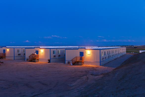
1 Update on Upcoming Learning Opportunities: GEOG Courses Related to Cities and the Economy Murray Rice Spring 2019: GEOG 4230 (Location Intelligence: Business GIS) Focus on GIS applications in business Hands-on experience with a series of industryfocused GIS labs Hospitality services (restaurants) Real estate Insurance Marketing Transportation Lab use a variety of business GIS and database software packages All cited/used at my recent conference Maptitude (advanced applications) Alteryx Esri Business Analyst Web $2000 in scholarships to be awarded by industry partners for best project work (Invesco Real Estate of Dallas) Update on Upcoming Learning Opportunities: GEOG Courses Related to Cities and the Economy Fall 2019: Murray Rice GEOG 4220 (Applied Retail Geography) Specific focus: retail and service industry issues and applications Labs combine GIS and fieldwork experience Class completes a semester project focused on a real-world problem, working with an actual retail/service business $1000 in scholarships to be awarded by industry partners for best project work (Buxton Company of Fort Worth) Q: What is this? Q: So what is this? What is in this area of the country? Key City Focus: Williston, ND Foundational Issue for Today: How do you manage urban and economic development in a place where the economy is marked by booms and busts? 1
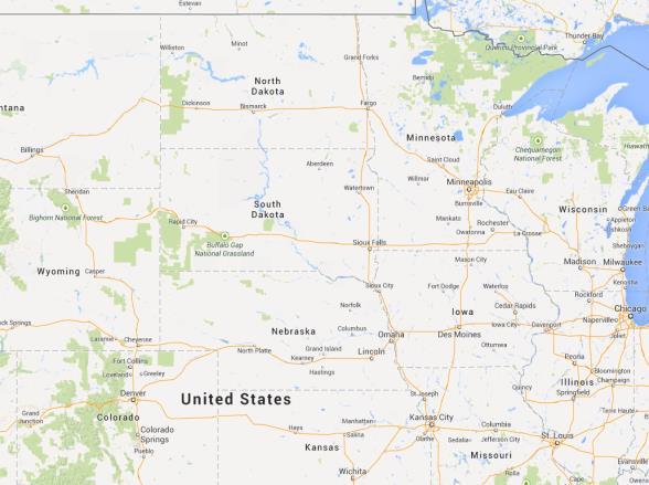
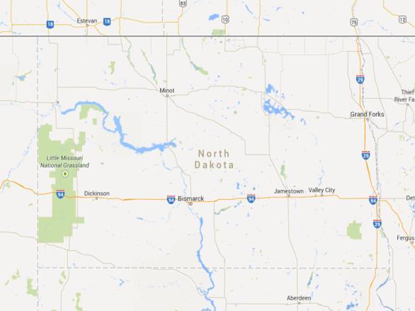

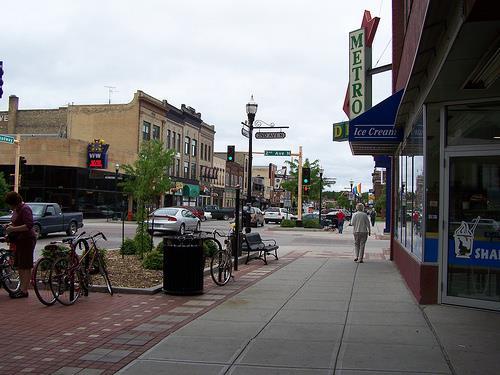

2 Williston, ND Williston Minneapolis Chicago Watford City North Dakota Fargo Denver Kansas City Williston 2


")


3 Historical Population Trends Williston, ND Watford City, ND Things were looking pretty good (at least in terms of jobs and incomes) But things have a way of cycling around World Oil Prices Williston s Problem beginning in late


4 Update: Oil Prices up to 2018 Q: What do you do if you were the mayor of a place like Williston in the midst of a boom? What do you do when your local economy starts to crash? There has been a recent oil price recovery but will it last? What do you do if you are an employer in the area and you are trying to find people so you can run your business? The Regions of North America Great Plains/Empty Interior Our focus today is on the region that we call home The Great Plains & Prairies Q: What are your perceptions of the plains region? Some photographic impressions of the region 4


5 The Great Plains The Great Plains The Great Plains The Great Plains The Great Plains Great Plains/Empty Interior Easy to define the Great Plains region based on physical geography: flat Q: is there anything else that characterizes this place as a region (common elements)? The region is big should we really subdivide the region to recognize divisions within it? 5


6 Great Plains/Empty Interior We ll talk today about 1. The hazards that are part of life in the region 2. The agricultural economy of the region 3. The resource use issues that must be solved for life in the region to continue as it is 1. Hazards The region is impacted by a variety of environmental hazards Snowstorms Thunderstorms Tornadoes Common elements: 1. fast-moving, 2. hard to predict (except by season) 6
 and for individuals (personal safety) A particular concern for the")


7 Lightning Strike Map 1. Hazards Q: how does it impact our region that we live with these kinds of hazards? Impacts are large, both for the broad economy (business loss, unemployment) and for individuals (personal safety) A particular concern for the southeastern part of the Great Plains region 2. Agriculture and Regional Change Agriculture has long been a focal point for life in the region We see the national importance of the region for certain kinds of crops on agricultural production maps The inland northwest and the northern and southern plains dominate production in many grain crops Farming-Dependent Counties in the United States 2. Agriculture and Regional Change One major concern for the region is population loss Regions dominated by agriculture have been experiencing outmigration and net population loss worldwide Happening in parts of North America for the last 50 years 7


8 Mostly farmingdependent, have lost population Echoes of the Past: Population Change, 1930 to Agriculture and Regional Change Same region, similar issues Farming isn t the only factor linked to population loss, but it is an important element As a related aside, what s going on here? Median Age Change, 2010 to Resource Use To wrap up our discussion today, we ll return to an issue we started to examine earlier in the course: water resource issues Water is one of the most familiar concerns in the region: how much do we have, and who gets it One of the great issues of our time for western North America is where are we on the supply-demand balance 8


9 Rainfall in the region is extremely inconsistent from year to year, and season to season 3. Resource Use Q: what are some strategies that people on the plains use to cope? 3. Resource Use On the demand side, we know that growing populations are rapidly using all water that is available Key question is, what s the limit? How much water can we rely on using, year after year? When are we drawing too much? Key Water Use Venue: The Ogallala Aquifer of the Central Plains Historically, one of the most important resources for agriculture in the region However, it is also under extreme threat due to longterm overuse Depth to Water Across the Entire Aquifer Region Especially in the Texas Panhandle, it is necessary to drill more than 200 feet before reaching water 9


10 All of this evidence raises questions about how sustainable the aquifer actually is Red: Under 25 years of aquifer life remaining Salina Wichita Brown: Aquifer Already Depleted Salina 3. Resource Use One key reason for a lack of water in some regions, and an abundance in others, is the concept of rainshadow See rainshadow clearly on a map, as well as in profile view Wichita Rainshadow in profile view 10

 100")

11 North Bend, WA (just east of Seattle) 100 miles east and 90 minutes later 11
3/21/2019. Q: What is this? What is in this area of the country? Q: So what is this? GEOG 3100 Next Week
 Tuesday: Thursday: GEOG 3100 Next Week Discussion of The South region (in this room) GIS Computer Lab Time (ENV Building, Room 340 more on this in class on Tuesday next week) Ahead of this lab time, please
Written by Vowery Dodd Carlile and Traci Burnett Illustrated by Karen Birchak
 Written by Vowery Dodd Carlile and Traci Burnett Illustrated by Karen Birchak Table of Contents INTRODUCTION...5 TO THE TEACHER...6 STORIES ABOUT TEXAS: Background, Vocabulary Activities, Discussion Questions,
GIS and Business Location Analytics
 UNT s course evaluation system (SPOT - Student Perceptions of Teaching) opened on Monday, April 16 and runs through Thursday, May 3. You should have received an email on April 16 providing guidance on
ENV208/ENV508 Applied GIS. Week 1: What is GIS?
 ENV208/ENV508 Applied GIS Week 1: What is GIS? 1 WHAT IS GIS? A GIS integrates hardware, software, and data for capturing, managing, analyzing, and displaying all forms of geographically referenced information.
Name: Date: Period: #: Chapter 1: Outline Notes What Does a Historian Do?
 Name: Date: Period: #: Chapter 1: Outline Notes What Does a Historian Do? Lesson 1.1 What is History? I. Why Study History? A. History is the study of the of the past. History considers both the way things
Using the ACS to track the economic performance of U.S. inner cities
 Using the ACS to track the economic performance of U.S. inner cities 2017 ACS Data Users Conference May 11, 2017 Austin Nijhuis, Senior Research Analyst Initiative for a Competitive Inner (ICIC) ICIC ICIC
Spatial Organization of Data and Data Extraction from Maptitude
 Spatial Organization of Data and Data Extraction from Maptitude N. P. Taliceo Geospatial Information Sciences The University of Texas at Dallas UT Dallas GIS Workshop Richardson, TX March 30 31, 2018 1/
Content Area: Social Studies Standard: 1. History Prepared Graduates: Develop an understanding of how people view, construct, and interpret history
 Standard: 1. History Develop an understanding of how people view, construct, and interpret history 1. Organize and sequence events to understand the concepts of chronology and cause and effect in the history
Chapter 2 - Lessons 1 & 2 Studying Geography, Economics
 Chapter 2 - Lessons 1 & 2 Studying Geography, Economics How does geography influence the way people live? Why do people trade? Why do people form governments? Lesson 1 - How Does Geography Influence the
North Dakota Lignite Energy Industry's Contribution to the State Economy for 2002 and Projected for 2003
 AAE 03002 March 2003 North Dakota Lignite Energy Industry's Contribution to the State Economy for 2002 and Projected for 2003 Randal C. Coon and F. Larry Leistritz * This report provides estimates of the
Assessing Social Vulnerability to Biophysical Hazards. Dr. Jasmine Waddell
 Assessing Social Vulnerability to Biophysical Hazards Dr. Jasmine Waddell About the Project Built on a need to understand: The pre-disposition of the populations in the SE to adverse impacts from disaster
Omaha Trade Area Study No. 5: Omaha Spheres of Influence
 University of Nebraska at Omaha DigitalCommons@UNO Publications Archives, 1963-2 Center for Public Affairs Research 1968 Omaha Trade Area Study No. 5: Omaha Spheres of Influence Harold J. Retallick University
Regions and Themes. Four Ground Rules for this Class. Regions and Themes 1/16/2019. GEOG 3100: US and Canada Economies, Cities, and Sustainability
 GEOG 3100: US and Canada Economies, Cities, and Sustainability 1 2 Four Ground Rules for this Class 1. Do your work 2. Come to learn 3. Participate 4. Consider others My goal here is to serve your needs
CHAPTER 1: EXPLORING GEOGRAPHY
 CHAPTER 1: EXPLORING GEOGRAPHY Please Do Now: In your PDN section of your binder answer the following with one or two sentences: What is Geography? What is Geography? The study of where people, places,
Chapter 2: Studying Geography, Economics, and Citizenship
 Chapter 2: Studying Geography, Economics, and Citizenship Lesson 2.1 Studying Geography I. Displaying the Earth s Surface A. A globe of the Earth best shows the sizes of continents and the shapes of landmasses
WeatherManager Weekly
 Issue 288 July 14, 2016 WeatherManager Weekly Industries We Serve Agriculture Energy/Utilities Construction Transportation Retail Our Weather Protection Products Standard Temperature Products Lowest Daily
What Is the Weather Like in Different Regions of the United States?
 Learning Set 1 What Is Weather, and How Is It Measured and Described? 1.3 Explore What Is the Weather Like in Different Regions of the United States? trends: patterns or tendencies you can see over a broad
Unit 4. This unit will enable you to improve coordination and communication with State and local agencies when hazardous weather threatens.
 Unit 4 This unit will enable you to improve coordination and communication with State and local agencies when hazardous weather threatens. In this unit we will discuss the role of Emergency Managers in
Life After College. How should I select my major? What should I select as my major? Will there be a job for me?
 Life After College How should I select my major? What should I select as my major? Will there be a job for me? It s not the degree.... It isn t the piece of paper that matters. There are easy routes to
Everly said the new CASA weather radar can give updated information in about a minute.
 March 17, 2013 Cleburne Times Review Ahead of the curve CASA radar offers high-resolution imagery By Tammye Nash/reporter3@trcle.com Benjamin Franklin once said, Time is money. But when it comes to tornado
Factors Affecting Human Settlement
 Factors Affecting Human Settlement Physical Factors One of the most basic factors affecting settlement patterns is the physical geography of the land. Climate is key, because if a place is too dry, too
Economics 312: Urban Land Economics University of Victoria Midterm Examination #1 VERSION 1 SOLUTIONS Spring 2018 Instructor: Martin Farnham
 Economics 312: Urban Land Economics University of Victoria Midterm Examination #1 VERSION 1 SOLUTIONS Spring 2018 Instructor: Martin Farnham Midterm Exam #1 Section 1: Multiple Choice (2 points each) Unless
IN VEHICLES: Do not try to outrun a tornado. Abandon your vehicle and hide in a nearby ditch or depression and cover your head.
 TORNADO SAFETY TORNADO! The very word strikes fear in many people. While a tornado is perhaps nature's most destructive storm, deaths and injuries can be prevented. By following Tornado Safety Rules, lives
An American Nadir: The Great Depression and Dust Bowl
 An American Nadir: The Great Depression and Dust Bowl Mary Selenke CE US History 102 March 4, 2017 1 American history has had extreme highs and lows, and during the early 1930 s, the Dust Bowl and Great
10/23/2017. Week 6. Retail and the Settlement Pattern. Whataburger Locations. A family-owned quick service restaurant chain
 Schedule Updates and Reminders Here are some important dates and items from our class schedule over the next few weeks: Mon, Oct 23: Commerce and the Settlement Pattern Wed, Oct 25: Talk by Amanda Regan
Lee County, Florida 2015 Forecast Report Population, Housing and Commercial Demand
 Lee County, Florida 2015 Forecast Report Population, Housing and Commercial Demand Thank you for purchasing this report, which contains forecasts of population growth, housing demand and demand for commercial
Key City Focus: Metro Tampa-St Petersburg
 Key City Focus: Metro Tampa-St Petersburg Tallahassee Jacksonville Orlando Tampa Miami Lakeland Clearwater Tampa St Petersburg Bradenton 1 Carriage Pointe: Mini Case Study The previous picture is from
APPENDIX V VALLEYWIDE REPORT
 APPENDIX V VALLEYWIDE REPORT Page Intentionally Left Blank 1.2 San Joaquin Valley Profile Geography The San Joaquin Valley is the southern portion of the Great Central Valley of California (Exhibit 1-1).
geographic patterns and processes are captured and represented using computer technologies
 Proposed Certificate in Geographic Information Science Department of Geographical and Sustainability Sciences Submitted: November 9, 2016 Geographic information systems (GIS) capture the complex spatial
Economic Geography of the Long Island Region
 Geography of Data Economic Geography of the Long Island Region Copyright 2011 AFG 1 The geography of economic activity requires: - the gathering of spatial data - the location of data geographically -
Techniques for Science Teachers: Using GIS in Science Classrooms.
 Techniques for Science Teachers: Using GIS in Science Classrooms. After ESRI, 2008 GIS A Geographic Information System A collection of computer hardware, software, and geographic data used together for
MARS AREA SCHOOL DISTRICT CURRICULUM GRADE: Grade 4
 MARS AREA SCHOOL DISTRICT CURRICULUM GRADE: Grade 4 Course Title: Social Studies Brief Description Overview: Students will explore the history, geography, government, and economy of the United States with
Minnesota K-12 Academic Standards in Social Studies. Grade 4: Geography of North America
 Minnesota K-12 Academic s in Social Studies Grade 4: Geography of North America 4 Describe how people take 1. Democratic government action to influence a depends on informed and decision on a specific
MARKET WIRE. Jason Vollmer (701) Trygg Olson (701) Nick Smith (701) Adam Allmaras (701)
 Trygg Olson (701) Nick Smith (701) Adam Allmaras (701)") MARKET WIRE Quick Notes: New news in the corn market is limited. Markets continue to see spillover from Friday s USDA report. Carryout was unchanged in Friday s report and exports continue to remain sluggish.
MARKET WIRE Quick Notes: New news in the corn market is limited. Markets continue to see spillover from Friday s USDA report. Carryout was unchanged in Friday s report and exports continue to remain sluggish.
Drought lesson plan ITEMS. Teachers lesson plan. Student assignments. About droughts. Real life stories. Droughts: Be prepared.
 Drought lesson plan The drought lesson plan provides teachers and students with an opportunity to investigate the Australian climate, water table and the impacts of drought through individual or classroom
ELEMENTS OF BASIC WORLD GEOGRAPHY TABLE OF CONTENTS UNIT 1 THE BASICS OF GEOGRAPHY AND NORTH AMERICA
 TABLE OF CONTENTS UNIT 1 THE BASICS OF GEOGRAPHY AND NORTH AMERICA IMPORTANT WORDS TO KNOW... 1 CHAPTER 1 THE BASICS OF GEOGRAPHY GEOGRAPHY... 2 TOOLS OF GEOGRAPHY... 3 EARTH...4 SEASONS, CLIMATE, AND
Homework III. Volcanological Exercises
 Page 1 of 5 EENS 3050 Tulane University Natural Disasters Prof. Stephen A. Nelson Homework III. Volcanological Exercises This page last updated on 16-Feb-2018 1. In your work as an insurance company executive
GEOGRAPHY (GE) Courses of Instruction
 Courses of Instruction") GEOGRAPHY (GE) GE 102. (3) World Regional Geography. The geographic method of inquiry is used to examine, describe, explain, and analyze the human and physical environments of the major regions of the
GEOGRAPHY (GE) GE 102. (3) World Regional Geography. The geographic method of inquiry is used to examine, describe, explain, and analyze the human and physical environments of the major regions of the
Village Weather, Snow, Ice, Breakup, Flooding, Fire sites
 Village Weather, Snow, Ice, Breakup, Flooding, Fire sites What is the weather like now in Villages?... 1 BREAKUP:... 2 Flooding... 3 Fires... 5 Weather Predictability, Weather and Ice Advisories and How
Planning for Economic and Job Growth
 Planning for Economic and Job Growth Mayors Innovation Project Winter 2012 Meeting January 21, 2012 Mary Kay Leonard Initiative for a Competitive Inner City AGENDA The Evolving Model for Urban Economic
Mapping Earth. How are Earth s surface features measured and modeled?
 Name Mapping Earth How are Earth s surface features measured and modeled? Before You Read Before you read the chapter, think about what you know about maps Record your thoughts in the first column Pair
[ 1.2 ] Texas Geography
![[ 1.2 ] Texas Geography](/thumbs/78/78091378.jpg "[ 1.2 ] Texas Geography") [ 1.2 ] Texas Geography [ 1.2 ] Texas Geography Learning Objectives Identify how geography helps people understand and organize information about a place. Compare the physical and human characteristics
[ 1.2 ] Texas Geography [ 1.2 ] Texas Geography Learning Objectives Identify how geography helps people understand and organize information about a place. Compare the physical and human characteristics
The Attractive Side of Corpus Christi: A Study of the City s Downtown Economic Growth
 The Attractive Side of Corpus Christi: A Study of the City s Downtown Economic Growth GISC PROJECT DR. LUCY HUANG SPRING 2012 DIONNE BRYANT Introduction Background As a GIS Intern working with the City
Third Grade Social Studies Indicators Class Summary
 History Standard Construct time lines to demonstrate an understanding of units of time and chronological order. 1. Define and measure time by years, decades and centuries. 2. Place local historical events
Crop / Weather Update
 Crop / Weather Update We would like to welcome you to another season of Doane s Weekly Crop Weather Update Progress Chartbook. The goal is to provide a quick visual overview of a number of the key gauges
Urban Foundations. Early American Cities. Early American Cities. Early American Cities. Cities in America to 1945
 Urban Foundations Cities in America to 1945 Early American Cities The design of early American cities was highly influenced by European traditions The roots of many of these traditions can in turn be traced
CLAREMONT MASTER PLAN 2017: LAND USE COMMUNITY INPUT
 Planning and Development Department 14 North Street Claremont, New Hampshire 03743 Ph: (603) 542-7008 Fax: (603) 542-7033 Email: cityplanner@claremontnh.com www.claremontnh.com CLAREMONT MASTER PLAN 2017:
WEATHER WATCH. As a Student Scientist, here is how you will use the Engineering Design Cycle
 WEATHER WATCH As a Student Scientist, here is how you will use the Engineering Design Cycle Project-Based Inquiry Science WW 2 What s the Big Challenge? Develop a Plan for Responding to a Severe Weather
The Future of Met Council Forecasts
 The Future of Met Council Forecasts Todd Graham todd.graham@metc.state.mn.us Dennis Farmer dennis.farmer@metc.state.mn.us Metropolitan Council Research Today s Agenda Why we forecast, how we use forecasts
An Assessment of People, Place and Business on Syracuse s Near Northside
 An Assessment of People, Place and Business on Syracuse s Near Northside May 2013 Report produced by Jon Glass, Kelly Montague and Mark Pawliw Edited by Jon Glass and Jonnell Robinson Syracuse Community
Geography 101: The Basics
 Geography 101: The Basics What is Geography? Geography is the study of the HUMAN and NON- HUMAN features of the Earth.! Geographers study where things are located why they are located in a specific place.!
Crop / Weather Update
 Crop / Weather Update This is our last for the 2018 planting, growing and harvesting seasons. USDA will publish their Crop Progress Report again in April 2019, and we will continue our coverage sometime
STUDY GUIDE. Exploring Geography. Chapter 1, Section 1. Terms to Know DRAWING FROM EXPERIENCE ORGANIZING YOUR THOUGHTS
 For use with textbook pages 19 22. Exploring Geography Terms to Know location A specific place on the earth (page 20) absolute location The exact spot at which a place is found on the globe (page 20) hemisphere
Unit 1 Test - Version A
 Unit 1 Test - Version A 1. Approximately, how many degrees of longitude equal one time zone change? a. 5 b. 10 c. 15 d. 20 e. 25 2. The city of Lewisville has a population of 1,000 people living in 100
Internet GIS Sites. 2 OakMapper webgis Application
 Internet GIS Sites # Name URL Description 1 City of Sugar Land http://www.sugarlandtx.gov/index.htm It is a city in Texas with 65,000 Residents. The City of Sugar Land, Texas, provides ArcIMS-based maps
PLANNING (PLAN) Planning (PLAN) 1
 Planning (PLAN) 1") Planning (PLAN) 1 PLANNING (PLAN) PLAN 500. Economics for Public Affairs Description: An introduction to basic economic concepts and their application to public affairs and urban planning. Note: Cross-listed
Planning (PLAN) 1 PLANNING (PLAN) PLAN 500. Economics for Public Affairs Description: An introduction to basic economic concepts and their application to public affairs and urban planning. Note: Cross-listed
Descriptive Statistics (And a little bit on rounding and significant digits)
") Descriptive Statistics (And a little bit on rounding and significant digits) Now that we know what our data look like, we d like to be able to describe it numerically. In other words, how can we represent
Descriptive Statistics (And a little bit on rounding and significant digits) Now that we know what our data look like, we d like to be able to describe it numerically. In other words, how can we represent
Office of Geographic Information Systems
 Winter 2007 Department Spotlight SWCD GIS by Dave Holmen, Dakota County Soil and Water Conservation District The Dakota County Soil and Water Conservation District (SWCD) has collaborated with the Dakota
Grade 4 Benchmarks. Benchmark Concepts Skills Essential Question(s)
") **Be aware of the use of and & or in the benchmark language related to Canada and Mexico; sometimes students may look at the US and one of our neighboring countries and other times students need to study
**Be aware of the use of and & or in the benchmark language related to Canada and Mexico; sometimes students may look at the US and one of our neighboring countries and other times students need to study
Geography for Life. Course Overview
 Geography for Life Description In Geography for Life students will explore the world around them. Using the six essential elements established by the National Geographic Society students will be able to
Severe Weather Hazards Are Real
 Severe Weather Hazards Are Real In the past 10 years, more than 40 people have died and dozens more injured as a result of weatherrelated events in Minnesota (not including motor vehicles.) The top severe
Natural Texas. Regions and Climates
 Natural Texas Regions and Climates Two Kinds: Physical geography Climate, vegetation, rivers, lakes, oceans, plateaus, plains, and mountain ranges Human geography Economic activities How we earn a living
Designing smart & Resilient cities:
 Designing smart & Resilient cities: How can Egyptian cities learn from an emerging global practice On the Cuspof Change Professor Samer Bagaeen FRICS MRTPI FRSA AoU 1. GLOBAL CHALLENGES POPULATION GROWTH,
LAB 3: THE SUN AND CLIMATE NAME: LAB PARTNER(S):
:") GEOG 101L PHYSICAL GEOGRAPHY LAB SAN DIEGO CITY COLLEGE SELKIN 1 LAB 3: THE SUN AND CLIMATE NAME: LAB PARTNER(S): The main objective of today s lab is for you to be able to visualize the sun s position
GEOG 101L PHYSICAL GEOGRAPHY LAB SAN DIEGO CITY COLLEGE SELKIN 1 LAB 3: THE SUN AND CLIMATE NAME: LAB PARTNER(S): The main objective of today s lab is for you to be able to visualize the sun s position
CASA WX DFW URBAN DEMONSTRATION NETWORK
 CASA WX DFW URBAN DEMONSTRATION NETWORK Goals Background on Regional CASA WX Project Explain the capabilities, structure of the Radar Network Present the CASA WX DFW Test Bed will be rolled out Describe
Exploring Social Capital in Busan and Gimhae, Korea:
 Exploring Social Capital in Busan and Gimhae, Korea: Perspectives from Social Trust and Social Risk Kazuo Ueda 1. Introduction My field of research is Risk Management and Insurance at Senshu University.
11/14/2017. Key City Focus: Phoenix
 Semester Project Reminder Semester Project presentations begin on Monday, November 20 (and continue on Monday, November 27 and Wednesday, November 27). See the presentation schedule posted online for your
A Case Study of Regional Dynamics of China 中国区域动态案例研究
 A Case Study of Regional Dynamics of China 中国区域动态案例研究 Shuming Bao Spatial Data Center & China Data Center University of Michigan 1:00 PM - 2:00 PM, Tue, Feb 6, 2018 EST USA A Case Study of Regional Dynamics
UTAH S STATEWIDE GEOGRAPHIC INFORMATION DATABASE
 UTAH S STATEWIDE GEOGRAPHIC INFORMATION DATABASE Data Information and Knowledge Management NASCIO Awards 2009 STATE GEOGRAPHIC INFORMATION DATABASE B. EXECUTIVE SUMMARY Utah has developed one of the most
A Shift to the Sunbelt
 Adam Giladi 4/1/13 A Shift to the Sunbelt The changing global economy has lead to an increased interconnection between nations and the mass movement of individuals from one area to another. This movement
Social Studies 3 Vocabulary Cards. century. History 1. period of 100 years
 century History 1 period of 100 years chronological History 1 in order of time decade History 1 period of 10 years timeline History 1 list of important events in the order in which they happened year History
Grades K-2 Social Studies GLE Comparison Chart
 Grades K-2 Social Studies GLE Comparison Chart Kindergarten Grade 1 No or Minimal 40% Change 1 10/25 GLEs Moderate 12% Change 2 3/25 GLEs 44% New Content 11/25 GLEs No or Minimal Change Moderate Change
Socials Studies. Chapter 3 Canada s People 3.0-Human Geography
 Socials Studies Chapter 3 Canada s People 3.0-Human Geography Physical Geography Study of the natural features of the Earth s surface including landforms, climate, ocean currents and flora and fauna Human
Maps and Globes. By Kennedy s Korner
 Maps and Globes By Kennedy s Korner Map Key or Symbols Maps use symbols to show places and things on Earth. Symbols are drawings that stand for something real. A map key tells you what each symbol stands
Radar Meteorology AOS 444 October 28, 2002 Laboratory 6: WATADS study of Oakfield tornado from KGRB
 Radar Meteorology AOS 444 October 28, 2002 Laboratory 6: WATADS study of Oakfield tornado from KGRB YOUR NAME: YOUR PARTNER S NAME: On July 18, 1996 the town of Oakfield, Wisconsin was all but destroyed
Revised February 9, 2017
 Revised February 9, 2017 Geography of the U.S. II-A-1* Apply geographic tools of title, grid system, legends, symbols, scale and compass rose to construct and interpret maps. II-A-2* Translate geographic
Geography. Mrs Breider
 Geography Mrs Breider Who are these people? What do they have in common? Results 2016-17 Year 13 % A*/A 36 % A*- B 60 % A*- E 99 Why choose Geography? Studying geography arms students with a mix of skills
Expanding Canada s Rail Network to Meet the Challenges of the Future
 Expanding Canada s Rail Network to Meet the Challenges of the Future Lesson Overview Rail may become a more popular mode of transportation in the future due to increased population, higher energy costs,
Grade 5. Practice Test. Dust Bowl Disaster
 Name Date Grade 5 Dust Bowl Disaster Today you will read the following passage. Read this passage carefully to gather information to answer questions and write an essay. Excerpt from Dust Bowl Disaster
Thursday, March 19, 2015 Issued: 1:00pm CDT
 Thursday, March 19, 2015 Issued: 1:00pm CDT Prepared by: Kurt Van Speybroeck/Victor Murphy/David Brown 817-978-1100 x 147 National Weather Service Southern Region Headquarters Regional Operations Center
Demographic Data in ArcGIS. Harry J. Moore IV
 Demographic Data in ArcGIS Harry J. Moore IV Outline What is demographic data? Esri Demographic data - Real world examples with GIS - Redistricting - Emergency Preparedness - Economic Development Next
Brazil The country of Brazil is used to consider the different climatic conditions that can occur and why that is. Sport
 SUBJECT : Geography 2014 15 Yr7 What is geography? Students are introduced to the topic of geography and why it is so important to our everyday lives. Within the subject students explore the differences
AP Human Geography Unit 7a: Services Guided Reading Mr. Stepek Introduction (Rubenstein p ) 1. What is the tertiary sector of the economy?
 1. What is the tertiary sector of the economy?") Public Business Consumer AP Human Geography Unit 7a: Services Guided Reading Mr. Stepek Introduction (Rubenstein p 372 374) 1. What is the tertiary sector of the economy? 2. What is a service activity?
Public Business Consumer AP Human Geography Unit 7a: Services Guided Reading Mr. Stepek Introduction (Rubenstein p 372 374) 1. What is the tertiary sector of the economy? 2. What is a service activity?
Introducing GIS analysis
 1 Introducing GIS analysis GIS analysis lets you see patterns and relationships in your geographic data. The results of your analysis will give you insight into a place, help you focus your actions, or
INDIANA ACADEMIC STANDARDS FOR SOCIAL STUDIES, WORLD GEOGRAPHY. PAGE(S) WHERE TAUGHT (If submission is not a book, cite appropriate location(s))
 WHERE TAUGHT (If submission is not a book, cite appropriate location(s))") Prentice Hall: The Cultural Landscape, An Introduction to Human Geography 2002 Indiana Academic Standards for Social Studies, World Geography (Grades 9-12) STANDARD 1: THE WORLD IN SPATIAL TERMS Students
Prentice Hall: The Cultural Landscape, An Introduction to Human Geography 2002 Indiana Academic Standards for Social Studies, World Geography (Grades 9-12) STANDARD 1: THE WORLD IN SPATIAL TERMS Students
Population and Employment Forecast
 Population and Employment Forecast How Do We Get the Numbers? Thurston Regional Planning Council Technical Brief Updated July 2012 We plan for forecast growth in Population and Employment, but where do
Climate Change: Why Worry?
 Climate Change: Why Worry? Lesson Overview Students will explore the meaning of Climate Change, with an emphasis on the impact expected on future human life, the adaptations which will be required, and
22 cities with at least 10 million people See map for cities with red dots
 22 cities with at least 10 million people See map for cities with red dots Seven of these are in LDC s, more in future Fastest growing, high natural increase rates, loss of farming jobs and resulting migration
Applications on Slope Land Management through GIS Technology
 Applications on Slope Land Management through GIS Technology Hsiu-Yi Ko, Jo-Yu Liu,Tai-Chung Hsiao, Tian-Ying Chou, Ying-Hui Chang Geographic Information Systems Research Center of Feng Chia University
FRQ 1 As a country economically develops, the employment mix for various sectors of the economy changes.
 AP Human Geography Unit VI. Industrialization and Economic Development Free Response Questions FRQ 1 As a country economically develops, the employment mix for various sectors of the economy changes. A)
Personal Introduction
 RESEARCH REPORT 1 Personal Introduction Maurits Krabben Hi fellow MUN enthusiasts. Allow me to introduce myself. I am Maurits and I will be your chair throughout Calsmun 2019. This is my first time chairing
Complete Weather Intelligence for Public Safety from DTN
 Complete Weather Intelligence for Public Safety from DTN September 2017 White Paper www.dtn.com / 1.800.610.0777 From flooding to tornados to severe winter storms, the threats to public safety from weather-related
NATIONAL SENIOR CERTIFICATE GRADE 12
 NATIONAL SENIOR CERTIFICATE GRADE 12 GEOGRAPHY P1 FEBRUARY/MARCH 2015 MARKS: 225 TIME: 3 hours This question paper consists of 12 pages and an annexure of 12 pages. *GEOGE1* Geography/P1 2 INSTRUCTIONS
Your web browser (Safari 7) is out of date. For more security, comfort and. the best experience on this site: Update your browser Ignore
 is out of date. For more security, comfort and. the best experience on this site: Update your browser Ignore") Your web browser (Safari 7) is out of date. For more security, comfort and Activityengage the best experience on this site: Update your browser Ignore Introduction to GIS What is a geographic information
Your web browser (Safari 7) is out of date. For more security, comfort and Activityengage the best experience on this site: Update your browser Ignore Introduction to GIS What is a geographic information
American Tour: Climate Objective To introduce contour maps as data displays.
 American Tour: Climate Objective To introduce contour maps as data displays. www.everydaymathonline.com epresentations etoolkit Algorithms Practice EM Facts Workshop Game Family Letters Assessment Management
Students will be able, using GIS, to locate the largest and most destructive earthquakes;
 Exploring Earthquake Hazards with GIS Laboratory for Introduction to Geophysics, Spring 2007 Prof. Constantin Cranganu Brooklyn College of the City University of New York Learning Objectives: Students
Map your way to deeper insights
 Map your way to deeper insights Target, forecast and plan by geographic region Highlights Apply your data to pre-installed map templates and customize to meet your needs. Select from included map files
January 25, Summary
 January 25, 2013 Summary Precipitation since the December 17, 2012, Drought Update has been slightly below average in parts of central and northern Illinois and above average in southern Illinois. Soil
BROOKINGS May
 Appendix 1. Technical Methodology This study combines detailed data on transit systems, demographics, and employment to determine the accessibility of jobs via transit within and across the country s 100