SPECIES FACT SHEET Common Name: Scientific Name: Technical Description: Distinctive characters: Similar species:
|
|
|
- June Sutton
- 5 years ago
- Views:
Transcription
1 SPECIES FACT SHEET Common Name: Platyhypnidium moss Scientific Name: Platyhypnidium riparioides Recent synonym: Eurhynchium riparioides, Rhynchostegium riparioides Phylum: Bryophyta Class: Bryopsida Order: Hypnales Family: Brachytheciaceae Technical Description: Shoots to 2 mm wide, prostrate, often curved, with a glossy or metallic sheen, green, yellowish-green, brownish-green or copper-colored above, blackening below, 2-15 cm long, irregularly branched. Leaves x mm, broadly ovate-lanceolate to nearly round, spreading, variously plane, concave, infolded, or loosely twisted near the tip, often oriented somewhat horizontally and giving the shoots a loosely flattened appearance, leaves sometimes lacerated or stripped off by stream scour; costa 1/2 to 3/4 the length of the leaf, sometimes extending nearly to the apex, sometimes forked, often ending in a short spine or tooth at the tip; apex of leaves rounded; margins plane, serrulate nearly to base; median leaf cells long and narrow, x 4-5 μm. Capsules uncommon. Distinctive characters: (1) Robust matformer in and along streams, (2) leaves broadly rounded with serrulate margins, (3) metallic green to brownish coppery sheen. Similar species: Hygrohypnum species occur in the same habitat and may have similar orbicular leaves, but never have serrulate margins. Other descriptions and illustrations: Crum 1983: 313; Crum & Anderson 1981: 1072; Lawton 1971: 302; Sharp et al. 1994: 939; Smith 1978: 603. Life History: Details for this species are not documented. The protonema is inconspicuous, forming buds and shoots in the usual fashion of moss growth and development. Capsules are uncommon, but fruiting in summer and fall. Most bryophytes in splash zone habitats are limited to vegetative reproduction, but tend to occur in large monotypic mats that produce many viable fragments for regeneration. Range, Distribution, and Abundance: Widespread in Northern Hemisphere, circumboreal and south to North Africa and northern South America. In the Pacific Northwest, British Columbia south to California, east to Montana. 1
2 Documented on: National Forests: Columbia River Gorge NSA, Siuslaw. BLM Districts: Coos Bay, Eugene. Widespread but uncommon, probably undercollected. Habitat Associations: Aquatic to emergent, forming mats on rocks, wood, or roots of trees in streams or in spray zone of streams and waterfalls. Partial to full shade. Elevation sea level to about 3000 feet. Forest types include Pseudotsuga menziesii, Tsuga heterophylla, and Picea sitchensis associations. Threats: Road construction, recreational climbing in streambeds (canyoning or canyoneering) and upstream activities such as logging, road construction, and dredging that cause excessive siltation could be detrimental. Water diversion would probably decimate populations. It is unlikely that grazing has much effect other than possible siltation problems. Conservation Considerations: Because Platyhypnidium riparioides is attached to rocks and other substrates in stream beds, riparian buffers alone may not adequately protect populations because of sediment transport within stream channels. Wagner (1997) reported several populations of Platyhypnidium in stream channels on the Eugene BLM District, but Goldenberg (2004) could not relocate some of these and suspected that siltation from nearby logging on private land had buried them. Control of silt-causing activity upstream may be the only way to protect this species, and may not be possible where private lands are interspersed with public lands. Preparer: John A. Christy Date Completed: May 2006 Updated by Camille Duncan in February 2010 (Update added Attachment 1: Photos, to the Species Fact Sheet.) ATTACHMENTS: (1) Photos 2
3 References Crum, H Mosses of the Great Lakes Forest. 3rd edition. University of Michigan Herbarium, Ann Arbor. 417 pp. & L.E. Anderson Mosses of Eastern North America. 2 volumes. Columbia University Press, New York pp. Goldenberg, D Sighting form for Platyhypnidium riparioides, Wolf Creek tributary. Eugene District, Bureau of Land Management. Lawton, E Moss Flora of the Pacific Northwest. Hattori Botanical Laboratory, Nichinan, Japan. 362 pp. Montana Natural Heritage Program Plant species of concern. Resource Information System, Montana State Library. nhp.nris.state.mt.us/plants/reports/2003_psoc_list.pdf Oregon Natural Heritage Information Center Rare, threatened and endangered species of Oregon. Oregon Natural Heritage Information Center, Oregon State University. Portland. 104 pp. Sharp, A.J., H. Crum & P.M. Eckel (eds) The Moss Flora of Mexico. 2 volumes. Memoirs of the New York Botanical Garden 69: Smith, A.J.E The Moss Flora of Britain and Ireland. Cambridge University Press, Cambridge. 706 pp. Wagner, D.H Inventory of bryophytes of Wolf Creek Watershed, Eugene District, Bureau of Land Management, Lane County, Oregon. Report to Eugene BLM District. Northwest Botanical Institute, Eugene. 38 pp + appendices. Washington Natural Heritage Program Working list of rare mosses. mosses.html 3


4 Attachment 1: Photos All photos by Dr. Judy Harpel, under contract with the Oregon/Washington Bureau of Land Management Whole mount dry Whole mount wet 4

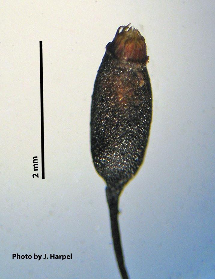
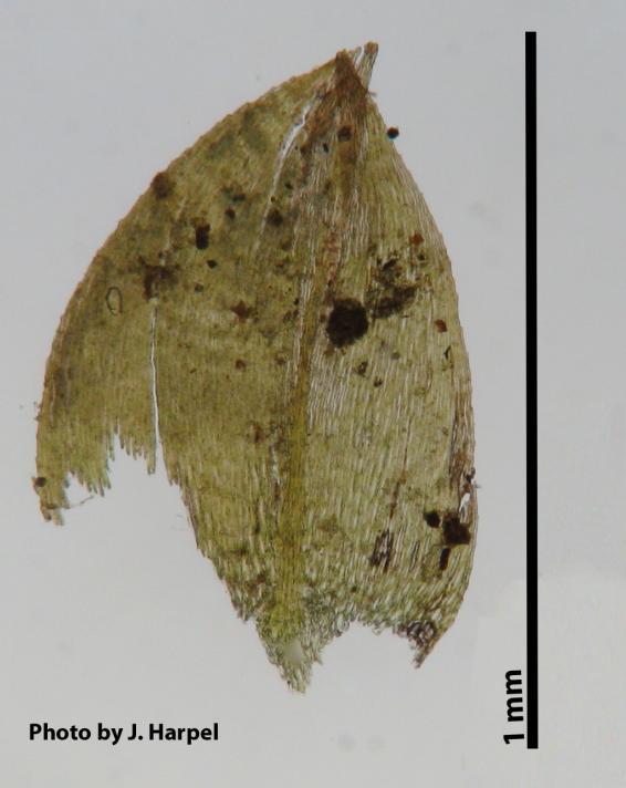
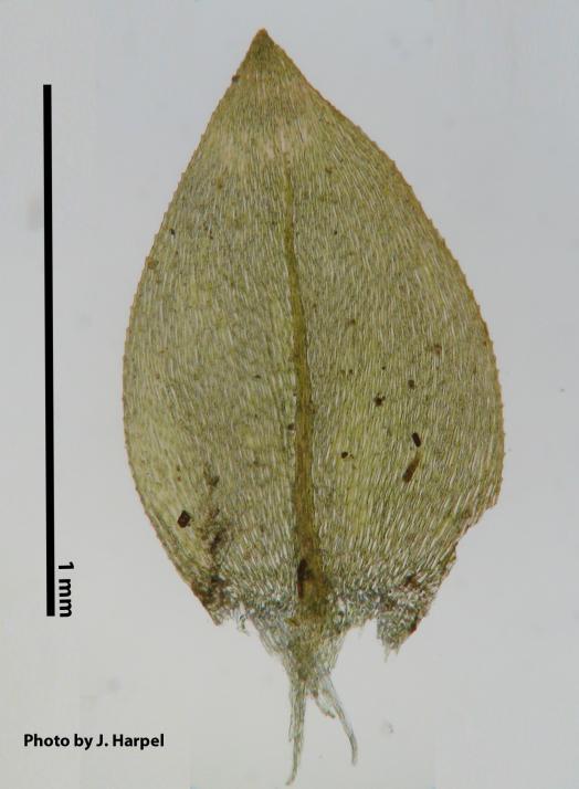
5 Whole mount with sporophyte Sporophyte close-up Stem leaf Branch leaf 5


6 Stem leaf apex Branch leaf apex 6


7 Stem leaf alar and basal cells Branch leaf alar and basal cells 7


8 Stem leaf upper medial cells Branch leaf upper medial cells 8
SPECIES FACT SHEET. Taxonomic Note: None.
 SPECIES FACT SHEET Common Name: Granite moss, Lantern moss Scientific Name: Andreaea nivalis Hook. Recent synonyms: Andreaea baileyi Holz. A. macounii Kindb. in Mac. Division: Bryophyta Class: Bryopsida
A New Locality of Fossombronia mylioides (Fossombroniaceae, Marchantiophyta)
") Bull. Natl. Mus. Nat. Sci., Ser. B, 42(1), pp. 19 23, February 22, 2016 A New Locality of Fossombronia mylioides (Fossombroniaceae, Marchantiophyta) Masanobu Higuchi Department of Botany, National Museum
Bull. Natl. Mus. Nat. Sci., Ser. B, 42(1), pp. 19 23, February 22, 2016 A New Locality of Fossombronia mylioides (Fossombroniaceae, Marchantiophyta) Masanobu Higuchi Department of Botany, National Museum
Overview. Revised through 30 June Initial Groups ("naked-eye" characters)
") Overview Revised through 30 June 2010 Initial Groups ("naked-eye" characters) Plants essentially leafless, consisting of strongly inclined, highly asymmetric capsules on a stout papillose seta; the "bug-on-a-stick"
Overview Revised through 30 June 2010 Initial Groups ("naked-eye" characters) Plants essentially leafless, consisting of strongly inclined, highly asymmetric capsules on a stout papillose seta; the "bug-on-a-stick"
S. SANDHYA RANI, M. SOWGHANDIKA,
 S. SANDHYA RANI, M. SOWGHANDIKA, 76 Habitat: Rare, grows on red rocks over soil. Specimen examined: Coffee plantations in Galikonda (VSKP), MS 33959. India : Darjeeling, Sikkim, Khasi hills. World : East
APPENDIX A REACH DECRIPTIONS. Quantico Creek Watershed Assessment April 2011
 APPENDIX A REACH DECRIPTIONS Basin 615, South Fork of Quantico Creek - Project Reach Descriptions Reach Name: 615-A Coordinates (NAD 83, Virginia State Plane North): 11796510.57, 6893938.95 to 11801555.79,
Case Study 2: Twenty-mile Creek Rock Fords
 Case Study : Twenty-mile Creek Rock Fords Location Crossing Description Washington. Okanagan National Forest. Methow Valley Ranger District. Chewuch river basin, East Chewuch Road. The Twenty-mile Creek
Fickeisen Plains Cactus (Pediocactus peeblesianus ssp. fickeiseniae)
") Fickeisen Plains Cactus (Pediocactus peeblesianus ssp. fickeiseniae) Monitoring Report Salt Trail Canyon Monitoring Site 2006-2008 Daniela Roth Navajo Natural Heritage Program Department of Fish & Wildlife
Fickeisen Plains Cactus (Pediocactus peeblesianus ssp. fickeiseniae) Monitoring Report Salt Trail Canyon Monitoring Site 2006-2008 Daniela Roth Navajo Natural Heritage Program Department of Fish & Wildlife
The Invasion of False Brome in Western Oregon
 The Invasion of False Brome in Western Oregon GIS II Presentation Winter 2006 Will Fellers Kurt Hellerman Kathy Strope Statia Cupit False Brome (Brachypodium sylvaticum) Perennial bunchgrass native to
PENNSYLVANIA DEPARTMENT OF TRANSPORTATION ENGINEERING DISTRICT 3-0
 PENNSYLVANIA DEPARTMENT OF TRANSPORTATION ENGINEERING DISTRICT 3-0 LYCOMING COUNTY S.R.15, SECTION C41 FINAL HYDROLOGIC AND HYDRAULIC REPORT STEAM VALLEY RUN STREAM RELOCATION DATE: June, 2006 REVISED:
A handful of primary features are useful for distinguishing water primrose (Ludwigia) from other plants. Understand what to look for, such as leaf
 from other plants. Understand what to look for, such as leaf") A handful of primary features are useful for distinguishing water primrose (Ludwigia) from other plants. Understand what to look for, such as leaf arrangement and number of petals. Pairing morphological
A handful of primary features are useful for distinguishing water primrose (Ludwigia) from other plants. Understand what to look for, such as leaf arrangement and number of petals. Pairing morphological
Flowering Rush (Butomus umbellatus) in Flathead Lake and River: An Integrated Invasive Plant Management Project
 in Flathead Lake and River: An Integrated Invasive Plant Management Project") Flowering Rush (Butomus umbellatus) in Flathead Lake and River: An Integrated Invasive Plant Management Project Mara Johnson, Center for Invasive Plant Management; Peter Rice, University of Montana; Virgil
Flowering Rush (Butomus umbellatus) in Flathead Lake and River: An Integrated Invasive Plant Management Project Mara Johnson, Center for Invasive Plant Management; Peter Rice, University of Montana; Virgil
Previously Used Scientific Names: Viburnum dentatum L. var. bracteatum
 Common Name: LIMEROCK ARROW-WOOD Scientific Name: Viburnum bracteatum Rehder Other Commonly Used Names: none Previously Used Scientific Names: Viburnum dentatum L. var. bracteatum Family: Caprifoliaceae
Natural Shoreline Landscapes on Michigan Inland Lakes
 Natural Shoreline Landscapes on Michigan Inland Lakes Excerpts from Chapters 2 and 3 Photo Photo by Jane by Jane Herbert Herbert Did you know? Twenty-four species of amphibians, 25 species of reptiles,
Plant Crib VERONICA. 1. Veronica serpyllifolia
 VERONICA 1. Veronica serpyllifolia Illustrations reproduced, with permission, from M. McC. Webster (1978). Flora of Moray, Nairn & East Inverness. Aberdeen. Subsp. humifusa (Dicks.) Syme Subsp. serpyllifolia
APPENDIX E. GEOMORPHOLOGICAL MONTORING REPORT Prepared by Steve Vrooman, Keystone Restoration Ecology September 2013
 APPENDIX E GEOMORPHOLOGICAL MONTORING REPORT Prepared by Steve Vrooman, Keystone Restoration Ecology September 2 Introduction Keystone Restoration Ecology (KRE) conducted geomorphological monitoring in
Highland Lake Bathymetric Survey
 Highland Lake Bathymetric Survey Final Report, Prepared For: The Town of Highland Lake 612 Lakeshore Drive Oneonta, AL 35121 Prepared By: Tetra Tech 2110 Powers Ferry Road SE Suite 202 Atlanta, GA 30339
Lower South Fork McKenzie River Floodplain Enhancement Project
 Lower South Fork McKenzie River Floodplain Enhancement Project McKenzie River Ranger District Willamette National Forest Project Location The project is located in the South Fork McKenzie River Watershed,
Instream Erosion Control General
 Instream Erosion Control General EROSION CONTROL TECHNIQUES Revegetation Temperate Climates Short-Term Non Vegetation Wet Tropics Long-Term Weed Control [1] Semi-Arid Zones Permanent [1] Weed control attributes
DETAILED DESCRIPTION OF STREAM CONDITIONS AND HABITAT TYPES IN REACH 4, REACH 5 AND REACH 6.
 DETAILED DESCRIPTION OF STREAM CONDITIONS AND HABITAT TYPES IN REACH 4, REACH 5 AND REACH 6. The Eklutna River was divided into study reaches (figure 1) prior to this site visit. Prominent geologic or
How Do Human Impacts and Geomorphological Responses Vary with Spatial Scale in the Streams and Rivers of the Illinois Basin?
 How Do Human Impacts and Geomorphological Responses Vary with Spatial Scale in the Streams and Rivers of the Illinois Basin? Bruce Rhoads Department of Geography University of Illinois at Urbana-Champaign
Assessment of the Hood River Delta Hood River, Oregon
 Assessment of the Hood River Delta Hood River, Oregon Pacific Northwest Waterways Association Annual Meeting October 13, 2010 Michael McElwee, Executive Director Port of Hood River Overview U.S. Army Corps
Assessment. Assessment
 2001 SPRINGBROOK CREEK RESTORATION - THREE YEAR POST-CONSTRUCTION REVIEW - Presented by Bruce Henderson and Andy Harris 2005 River Restoration Northwest Symposium Skamania Lodge, Washington www.hendersonlandservices.com
Common Name: SHOALS SPIDER-LILY. Scientific Name: Hymenocallis coronaria (J. LeConte) Kunth. Other Commonly Used Names: Cahaba lily, Catawba lily
 Kunth. Other Commonly Used Names: Cahaba lily, Catawba lily") Common Name: SHOALS SPIDER-LILY Scientific Name: Hymenocallis coronaria (J. LeConte) Kunth Other Commonly Used Names: Cahaba lily, Catawba lily Previously Used Scientific Names: Hymenocallis caroliniana
Common Name: SHOALS SPIDER-LILY Scientific Name: Hymenocallis coronaria (J. LeConte) Kunth Other Commonly Used Names: Cahaba lily, Catawba lily Previously Used Scientific Names: Hymenocallis caroliniana
Field Survey for Laramie Columbine. (Aquilegia laramiensis) In the Rawlins Field Office
 In the Rawlins Field Office") Field Survey for Laramie Columbine (Aquilegia laramiensis) In the Rawlins Field Office prepared for the Wyoming Natural Diversity Database, University of Wyoming, and the Bureau of Land Management, Rawlins
Field Survey for Laramie Columbine (Aquilegia laramiensis) In the Rawlins Field Office prepared for the Wyoming Natural Diversity Database, University of Wyoming, and the Bureau of Land Management, Rawlins
Habitat Assessment. Peggy Compton UW-Extension Water Action Volunteers Program Coordinator
 Habitat Assessment Peggy Compton UW-Extension Water Action Volunteers Program Coordinator Adapted from a presentation by Jean Unmuth, Water Quality Biologist, WI DNR dnr.wi.gov www.uwex.edu erc.cals.wisc.edu
TUNDRA. Column 1 biome name Column 2 biome description Column 3 examples of plant adaptations
 Biome Cards (pp. 1 of 7) Cut out each biome card and divide each card into three sections. Place all sections in a plastic storage bag. Have one bag for every two students. Column 1 biome name Column 2
Geomorphology Of The Chilliwack River Watershed Landform Mapping At North Cascades National Park Service Complex, Washington By National Park Service
 Geomorphology Of The Chilliwack River Watershed Landform Mapping At North Cascades National Park Service Complex, Washington By National Park Service READ ONLINE Snowshed contributions to the Nooksack
HAW CREEK, PIKE COUNTY, MISSOURI-TRIB TO SALT RIVER ERODING STREAM THREATHENING COUNTY ROAD #107, FOURTEEN FT TALL ERODING BANK WITHIN 4 FT OF THE
 HAW CREEK, PIKE COUNTY, MISSOURI-TRIB TO SALT RIVER ERODING STREAM THREATHENING COUNTY ROAD #107, FOURTEEN FT TALL ERODING BANK WITHIN 4 FT OF THE ROAD, PROJECT CONSTRUCTED IN 1 DAY, MARCH 10, 2009 BY
Your web browser (Safari 7) is out of date. For more security, comfort and the best experience on this site: Update your browser Ignore
 is out of date. For more security, comfort and the best experience on this site: Update your browser Ignore") Your web browser (Safari 7) is out of date. For more security, comfort and the best experience on this site: Update your browser Ignore ALLU VIAL FAN colluvial fan, debris cone For the complete encyclopedic
Your web browser (Safari 7) is out of date. For more security, comfort and the best experience on this site: Update your browser Ignore ALLU VIAL FAN colluvial fan, debris cone For the complete encyclopedic
COMMON CONIFERS OF THE PNW
 COMMON CONIFERS OF THE PNW The common conifers in the Pacific Northwest belong to the following genera: Abies, Calocedrus, Callitropsis, Juniperus, Larix, Picea, Pinus, Pseudotsuga, Taxus, Thuja, and Tsuga.
HUMAN IMPACTS AND RIVER CHANNEL ADJUSTMENT, NORTHEASTERN OREGON: IMPLICATIONS FOR RESTORATION. Patricia F. McDowell 1 INTRODUCTION
 Forthcoming in: Riparian Ecology and Management in Multi-Land Use Watersheds Symposium Proceedings, American Water Resources Association, Annual International Summer Specialty Conference, August 27-30,
ALBERTON GORGE WATER RIPPLE ROCKS
 These water ripple rocks were not laid down during the ice age by Lake Missoula. The rock strata that they are found in is vertical & not horizontal. Fossilized water ripples are formed on flat horizontal
Unconventional Wisdom and the Effects of Dams on Downstream Coarse Sediment Supply. Byron Amerson, Jay Stallman, John Wooster, and Derek Booth
 Unconventional Wisdom and the Effects of Dams on Downstream Coarse Sediment Supply 3 February 2009 Byron Amerson, Jay Stallman, John Wooster, and Derek Booth Sultan River, WA OBJECTIVE Consider the landscape
Appendix F Channel Grade Control Structures
 Stream Simulation Appendix F Channel Grade Control Structures This appendix briefly describes permanent grade control structures that are sometimes needed in the upstream and/or downstream reaches adjacent
Survey & Manage Compliance Report Pettijohn LSR Project Tom Quinn April 13, 2011 Updated and Edited by Kelly Wolcott May 4, 2011.
 Survey & Manage Compliance Report Pettijohn LSR Project Tom Quinn April 13, 2011 Updated and Edited by Kelly Wolcott May 4, 2011. The Pettijohn LSR Project is consistent with the Settlement Agreement finalized
Why Geomorphology for Fish Passage
 Channel Morphology - Stream Crossing Interactions An Overview Michael Love Michael Love & Associates mlove@h2odesigns.com (707) 476-8938 Why Geomorphology for Fish Passage 1. Understand the Scale of the
Session 1 Healthy Streams Stream Hydraulics Natural Channel Design
 Session 1 Healthy Streams Stream Hydraulics Natural Channel Design Bill Brant Heart of America Flyfishers Black & Veatch Kansas City, MO February 21, 2014 http://www.bobswebspace.com Audience? What do
Pacific Madrone Provenance Trial
 Pacific Madrone Provenance Trial 2014 Assessment of the Starker Forest site (Trial assessed Oct 15 & 20th, 2014) Draft Report 10/272014 (Photos: R.Sniezko) Objective Provide the first baseline data on
Kootenai River Habitat Restoration Program Update
 Kootenai River Habitat Restoration Program Update Kootenai Tribe of Idaho Kootenai Valley Resource Initiative November 19, 2012 Bonners Ferry, Idaho Changes to Kootenai Basin Beaver trapping Floodplain
Dan Miller + Kelly Burnett, Kelly Christiansen, Sharon Clarke, Lee Benda. GOAL Predict Channel Characteristics in Space and Time
 Broad-Scale Models Dan Miller + Kelly Burnett, Kelly Christiansen, Sharon Clarke, Lee Benda GOAL Predict Channel Characteristics in Space and Time Assess Potential for Fish Use and Productivity Assess
Other Commonly Used Names: wintergreen quillwort, evergreen quillwort
 Common Name: WINTER QUILLWORT Scientific Name: Isoetes hyemalis D.F. Brunton Other Commonly Used Names: wintergreen quillwort, evergreen quillwort Previously Used Scientific Names: none Family: Isoetaceae
Illinois State Water Survey Division
 Illinois State Water Survey Division SURFACE WATER SECTION SWS Miscellaneous Publication 108 SEDIMENT YIELD AND ACCUMULATION IN THE LOWER CACHE RIVER by Misganaw Demissie Champaign, Illinois June 1989
ADDRESSING GEOMORPHIC AND HYDRAULIC CONTROLS IN OFF-CHANNEL HABITAT DESIGN
 ADDRESSING GEOMORPHIC AND HYDRAULIC CONTROLS IN OFF-CHANNEL HABITAT DESIGN Conor Shea - Hydrologist U.S. Fish and Wildlife Service Conservation Partnerships Program Arcata, CA Learning Objectives Examine
PERENNATION IN CUSCUTA REFLEXA ROXB.
 [474] PERENNATION IN CUSCUTA REFLEXA ROXB. BY L. NARAYANA RAO Central College, University of Mysore, Bangalore (With I figure in the text) INTRODUCTION uscuta is a common parasite in several parts of India.
Useful Terms. Bryophyte Habitats
 Common Mosses and Liverworts of the Chicago Region Kalman Strauss, Jerry Jenkins, Gary Merrill, Charles DeLavoi, Juan Larraín, Laura Briscoe & Matt von Konrat The Field Museum, The Northern Forest Atlas
Common Name: FLORIDA ADDER S-MOUTH ORCHID. Scientific Name: Malaxis spicata Swartz. Other Commonly Used Names: none
 Common Name: FLORIDA ADDER S-MOUTH ORCHID Scientific Name: Malaxis spicata Swartz Other Commonly Used Names: none Previously Used Scientific Names: Malaxis floridana (Chapman) Kuntze, Microstylis floridana
S C I E N C E CHARACTERISTICS OF NONVASCULAR PLANTS SELF-INSTRUCTIONAL MATERIALS. Distance Education for Elementary Schools
 Modified In-School Off-School Approach Modules (MISOSA) S C I E N C E 5 Distance Education for Elementary Schools SELF-INSTRUCTIONAL MATERIALS CHARACTERISTICS OF NONVASCULAR PLANTS Department of Education
Squaw Creek. General Information
 General Information is a tributary to the Salmon River. It enters the north side of the river about 0 miles downstream of North Fork, Idaho. The study reach is about a 30 ft length of stream about 2 miles
The Example of the Lake Missoula Flood
 Chapter 85 The Example of the Lake Missoula Flood As already noted, uniformitarian hypotheses rarely, if ever, can be supported by extensive geological evidence. Part of this is due to the nature of the
EFFECTS OF RIPARIAN RETENTION (IN WATERSHEDS) ON ALLUVIAL FANS
 ON ALLUVIAL FANS") EFFECTS OF RIPARIAN RETENTION (IN WATERSHEDS) ON ALLUVIAL FANS TIM GILES GEOMORPHOLOGIST FLNRO EFFECTS OF RIPARIAN RETENTION (IN WATERSHEDS) ON ALLUVIAL FANS Description of alluvial fans Three case studies
EFFECTS OF RIPARIAN RETENTION (IN WATERSHEDS) ON ALLUVIAL FANS TIM GILES GEOMORPHOLOGIST FLNRO EFFECTS OF RIPARIAN RETENTION (IN WATERSHEDS) ON ALLUVIAL FANS Description of alluvial fans Three case studies
GET TO KNO W A NATIO NAL
 Your web browser (Safari 7) is out of date. For more security, comfort and the best experience on this site: Update your browser Ignore GET TO KNO W A NATIO NAL PARK W ITH FIEL DSCO PE Explore one of the
Common Name: GLADE WINDFLOWER. Scientific Name: Anemone berlandieri Pritzel. Other Commonly Used Names: southern thimble-weed
 Common Name: GLADE WINDFLOWER Scientific Name: Anemone berlandieri Pritzel Other Commonly Used Names: southern thimble-weed Previously Used Scientific Names: Anemone caroliniana Walter var. heterophylla
Common Name: GLADE MEADOW-PARSNIP. Scientific Name: Thaspium pinnatifidum (Buckley) Gray. Other Commonly Used Names: cutleaf meadow-parsnip
 Gray. Other Commonly Used Names: cutleaf meadow-parsnip") Common Name: GLADE MEADOW-PARSNIP Scientific Name: Thaspium pinnatifidum (Buckley) Gray Other Commonly Used Names: cutleaf meadow-parsnip Previously Used Scientific Names: none Family: Apiaceae/Umbelliferae
Common Name: GLADE MEADOW-PARSNIP Scientific Name: Thaspium pinnatifidum (Buckley) Gray Other Commonly Used Names: cutleaf meadow-parsnip Previously Used Scientific Names: none Family: Apiaceae/Umbelliferae
Year 6. Geography. Revision
 Year 6 Geography Revision November 2017 Rivers and World knowledge How the water cycle works and the meaning of the terms evaporation, condensation, precipitation, transpiration, surface run-off, groundwater
JEFFERSON COUNTY NOXIOUS WEED CONTROL BOARD 380 Jefferson Street, Port Townsend Ext. 205
 JEFFERSON COUNTY NOXIOUS WEED CONTROL BOARD 380 Jefferson Street, Port Townsend 98368 360 379-5610 Ext. 205 noxiousweeds@co.jefferson.wa.us BEST MANAGEMENT PRACTICES Meadow Knapweed (Centaurea jacea x
ODFW AQUATIC INVENTORY PROJECT OREGON PLAN FOR SALMON & WATERSHEDS STREAM RESTORATION HABITAT REPORT
 ODFW AQUATIC INVENTORY PROJECT OREGON PLAN FOR SALMON & WATERSHEDS STREAM RESTORATION HABITAT REPORT STREAM: BASIN: SURVEY TYPE: South Sister Creek (U-5) Smith River Pre-Tx DATE: January 7, 4 SURVEY CREW:
What is a landform? These shapes (except for bodies of water) on the earth s surface are all examples of landforms.
 on the earth s surface are all examples of landforms.") Landforms What is a landform? These shapes (except for bodies of water) on the earth s surface are all examples of landforms. archipelago a large group of many islands. The Hawaiian Islands Lighthouse
Landforms What is a landform? These shapes (except for bodies of water) on the earth s surface are all examples of landforms. archipelago a large group of many islands. The Hawaiian Islands Lighthouse
EXECUTIVE SUMMARY (Continued)
") EXECUTIVE SUMMARY In 1980, Congress passed the Pacific Northwest Electric Power Planning and Conservation Act which authorized creation of the Northwest Power and Conservation Council by the states of
EXECUTIVE SUMMARY In 1980, Congress passed the Pacific Northwest Electric Power Planning and Conservation Act which authorized creation of the Northwest Power and Conservation Council by the states of
APPENDIX A M&T/Llano Seco Long-Term Water Reliability Study These photos are examples of rock spurs in use throughout the United States
 APPENDIX A M&T/Llano Seco Long-Term Water Reliability Study These photos are examples of rock spurs in use throughout the United States Glenn Colusa Irrigation District completed a Sacramento River project
Lesson 9: California Ecosystem and Geography
 California Education Standards: Kindergarten, Earth Sciences 3. Earth is composed of land air, and water. As a basis for understanding this concept: b. Students know changes in weather occur from day to
Assignment 1. Measuring River Characteristics- Vernon Creek. Applied Fluvial Geomorphology Field Techniques EESc 435
 Assignment 1 Measuring River Characteristics- Vernon Creek Applied Fluvial Geomorphology Field Techniques EESc 435 Amanda Jardine 30100093 Jaime McDonald 14177083 Erica Massey 50870088 April 28, 2012 Introduction
Puakea, Hawaiÿi. Puakea, Hawaiÿi WATERSHED FEATURES
 Puakea, Hawaiÿi DAR Watershed Code: 85046 Puakea, Hawaiÿi WATERSHED FEATURES Puakea watershed occurs on the island of Hawaiÿi. The Hawaiian meaning of the name is white blossom. The area of the watershed
What is a landform? These shapes (except for bodies of water) on the earth s surface are all examples of landforms.
 on the earth s surface are all examples of landforms.") Landforms What is a landform? These shapes (except for bodies of water) on the earth s surface are all examples of landforms. archipelago a large group of many islands. The Hawaiian Islands Lighthouse
Landforms What is a landform? These shapes (except for bodies of water) on the earth s surface are all examples of landforms. archipelago a large group of many islands. The Hawaiian Islands Lighthouse
Aegopodium podagraria (Goutweed Bishop's weed )
") 1 of 5 9/24/2007 3:43 PM Home Early Detection IPANE Species Data & Maps Volunteers About the Project Related Information Catalog of Species Search Results :: Catalog of Species Search Aegopodium podagraria
1 of 5 9/24/2007 3:43 PM Home Early Detection IPANE Species Data & Maps Volunteers About the Project Related Information Catalog of Species Search Results :: Catalog of Species Search Aegopodium podagraria
 Red River Flooding June 2015 Caddo and Bossier Parishes Presented by: Flood Technical Committee Where the Rain Falls Matters I-30 versus I-20 I-20 Backwater and Tributary Floods (Localized) 2016 Flood
Assessing Michigan s Biological diversity. Michigan Natural Features Inventory MSU Extension
 Assessing Michigan s Biological diversity John Paskus,, Amy Derosier,, Edward Schools, and Helen Enander Michigan Natural Features Inventory MSU Extension Goal Provide scientifically based information
Introduction to Bryophyta
 Introduction to Bryophyta Botany Department, Brahmanand PG College, Bryophyta (Greek Bryon = Moss, phyton = plants) is a group of simplest and primitive plants of the class Embryophyta. The group is represented
Chapter 3 Erosion in the Las Vegas Wash
 Chapter 3 Erosion in the Las Vegas Wash Introduction As described in Chapter 1, the Las Vegas Wash (Wash) has experienced considerable change as a result of development of the Las Vegas Valley (Valley).
Invasive Species Management Plans for Florida
 Invasive Species Management Plans for Florida Air Potato Dioscorea bulbifera (L.) Dioscoreaceae INTRODUCTION A native to tropical Asia, air potato, Dioscorea bulbifera, was first introduced to the Americas
Review of Riparian Function Riparian Management Riparian Monitoring
 Review of Riparian Function Riparian Management Riparian Monitoring Water Shed Water Catchment Water catching creek Water shedding creek Properly functioning riparian area Properly Functioning Riparian
2 Georgia: Its Heritage and Its Promise
 TERMS region, erosion, fault, elevation, Fall Line, aquifer, marsh, climate, weather, precipitation, drought, tornado, hurricane, wetland, estuary, barrier island, swamp PLACES Appalachian Mountains, Appalachian
RAILWAYS AND FISH: HOW TO PROTECT AND ENHANCE FISH HABITAT VALUES AT STREAM CROSSINGS THROUGH PROJECT DESIGN AND CONSTRUCTION
 RAILWAYS AND FISH: HOW TO PROTECT AND ENHANCE FISH HABITAT VALUES AT STREAM CROSSINGS THROUGH PROJECT DESIGN AND CONSTRUCTION Rail Environment Conference November 2016 AGENDA Objective Background Benefits
Red River: The northern Border of Texas!
 From Palo Duro Canyon outside Amarillo Texas The prairie dog town fork of the Red River flows Headed cross the plains along the coast of Oklahoma To the Mississippi River and the Gulf of Mexico Red River
SECTION G SEDIMENT BUDGET
 SECTION G SEDIMENT BUDGET INTRODUCTION A sediment budget has been constructed for the for the time period 1952-2000. The purpose of the sediment budget is to determine the relative importance of different
Ecological Succession
 Ecological Succession Primary succession will ALWAYS be on areas where there is NO SOIL a) bare rock from a retreating glacier, b) newly cooled lava; c) abandoned lot with an impervious surface (parking
TSEGI WASH 50% DESIGN REPORT
 TSEGI WASH 50% DESIGN REPORT 2/28/2014 Daniel Larson, Leticia Delgado, Jessica Carnes I Table of Contents Acknowledgements... IV 1.0 Project Description... 1 1.1 Purpose... 1 Figure 1. Erosion of a Headcut...
FIELD IDENTIFICATION CARDS FOR INVASIVE NON-NATIVE PLANT SPECIES KNOWN TO THREATEN ARIZONA WILDLANDS.
 FIELD IDENTIFICATION CARDS FOR INVASIVE NON-NATIVE PLANT SPECIES KNOWN TO THREATEN ARIZONA WILDLANDS. PACKET CONTAINS INFORMATION ON 74 INVASIVE NON-NATIVE PLANTS INCLUDING: morphologic descriptions photos
EAGLES NEST AND PIASA ISLANDS
 EAGLES NEST AND PIASA ISLANDS HABITAT REHABILITATION AND ENHANCEMENT PROJECT MADISON AND JERSEY COUNTIES, ILLINOIS ENVIRONMENTAL MANAGEMENT PROGRAM ST. LOUIS DISTRICT FACT SHEET I. LOCATION The proposed
ODFW AQUATIC INVENTORY PROJECT STREAM REPORT
 ODFW AQUATIC INVENTORY PROJECT STREAM REPORT STREAM: BASIN: Basin Creek Willow Creek DATE: July 9 3, 9 SURVEY CREW: REPORT PREPARED BY: USGS MAPS: ECOREGION: Nicole Bushey / Emily Zimmermann Staci Stein
ENGINEERING APPROACHES TO SHORELINE PLACEMENT FROM COAST TO COAST
 ENGINEERING APPROACHES TO SHORELINE PLACEMENT FROM COAST TO COAST 237 237 237 217 217 217 200 200 200 0 0 0 163 163 163 131 132 122 80 119 27 252 174.59 83 36 118 110 135 120 112 92 56 62 102 130 Comparing
The Little Colorado River
 The Little Colorado River The Little Colorado River Junction of the Little Colorado River and the Colorado Grand Falls of the Little Colorado River The relief/topo map at the right shows the junction of
Landslide Computer Modeling Potential
 Landslide Computer Modeling Potential Michael D. Dixon, P.E. Civil Engineer Payette National Forest The Payette National Forest selected the Stability Index Mapping (SINMAP) model for use in identifying
Four Beetles Project Mendocino National Forest
 Four Beetles Project Mendocino National Forest Jose Chavez Bakersfield College 06/07/2016-08/02/2016 District Archeologist Curtis Fair & District Hydrologist John Kelley 2016 Acknowledgements: This project
Mobrand to Jones and Stokes. Sustainable Fisheries Management Use of EDT
 Sustainable Fisheries Management Use of EDT Ecosystem Diagnosis and Treatment EDT EDT designed to provide a practical, science-based approach for developing and implementing watershed plans. Provides decision
Manufacture of preserved plant specimens
 Manufacture of preserved plant specimens Type of preserved plant specimens 1. Dry curing Dry curing, the plants preserved in the herbarium. 2. Wet curing Wet mounted, both for animals and plants are usually
Tenmile Lakes Delta Building Study
 Tenmile Lakes Delta Building Study Since the late 1940 s, Tenmile Lakes has seen a sharp increase in sediment accumulation at the mouths of the tributaries that feed the lake. To monitor this sediment
Papaver Alboroseum Portage Poppy. Katie Shields Hort 5051 May 4, 2005
 Papaver Alboroseum Portage Poppy Katie Shields Hort 5051 May 4, 2005 Taxonomy Scientific Name: Papaver alboroseum Synonyms: None Common Names: Portage Poppy, Pale Poppy, Pink Poppy Family: Papaveraceae
Poor Pocket Moss Fissidens pauperculus
 COSEWIC Assessment and Status Report on the Poor Pocket Moss Fissidens pauperculus in Canada ENDANGERED 2001 COSEWIC status reports are working documents used in assigning the status of wildlife species
MaxDepth Aquatics, Inc.
 MaxDepth Aquatics, Inc. Bathymetry of Mirror Pond From Newport Bridge to Galveston Bridge Prepared for the City of Bend By Joseph Eilers & Benn Eilers MaxDepth Aquatics, Inc. Bend, OR June 2005 INTRODUCTION
Implementing a Project with 319 Funds: The Spring Brook Meander Project. Leslie A. Berns
 Implementing a Project with 319 Funds: The Spring Brook Meander Project Leslie A. Berns "...to acquire... and hold lands... for the purpose of protecting and preserving the flora, fauna and scenic beauties...
Stream Geomorphology. Leslie A. Morrissey UVM July 25, 2012
 Stream Geomorphology Leslie A. Morrissey UVM July 25, 2012 What Functions do Healthy Streams Provide? Flood mitigation Water supply Water quality Sediment storage and transport Habitat Recreation Transportation
AN ILLUSTRATED KEY TO THE GROSSULARIACEAE OF ALBERTA
 AN ILLUSTRATED KEY TO THE GROSSULARIACEAE OF ALBERTA Compiled and written by Lorna Allen & Linda Kershaw April 2017 This key was compiled using information primarily from Moss (1983), Douglas et. al. (1999)
Eagle Creek Post Fire Erosion Hazard Analysis Using the WEPP Model. John Rogers & Lauren McKinney
 Eagle Creek Post Fire Erosion Hazard Analysis Using the WEPP Model John Rogers & Lauren McKinney Columbia River Gorge at Risk: Using LiDAR and GIS-based predictive modeling for regional-scale erosion susceptibility
Briggs Lake Water Quality Report 2014
 Briggs Lake Water Quality Report 2014 Seasonal Report for Briggs Lake Green Oak Township, Livingston Co. T1N, R6E, Sec. 3,4 74 Surface Acres 414 Hadley Street Holly, MI 48442 Main Phone: 248-634-8388 Northern
Key to West Coast Spartina Species Based on Vegetative Characters
 Glossary Accuminate - tapering to a sharp tip and having concave sides just before the tip. Caespitose - growing in tufts. Glabrous - having a smooth, shiny surface. Internode - the region of a stem between
Carmel River Bank Stabilization at Rancho San Carlos Road Project Description and Work Plan March 2018
 Carmel River Bank Stabilization at Rancho San Carlos Road Project Description and Work Plan March 2018 EXISTING CONDITION The proposed Carmel River Bank Stabilization at Rancho San Carlos Road Project
Natural Shoreline Landscapes on Michigan Inland Lakes
 Natural Shoreline Landscapes on Michigan Inland Lakes Excerpts from Chapters 2 and 3 Photo Photo by Jane by Jane Herbert Herbert Session topics Characteristics of natural and altered shorelines Lakes,
Tropical Moist Rainforest
 Tropical or Lowlatitude Climates: Controlled by equatorial tropical air masses Tropical Moist Rainforest Rainfall is heavy in all months - more than 250 cm. (100 in.). Common temperatures of 27 C (80 F)
Stream Autotrophs. Benthic 10/3/13
 Stream Autotrophs Benthic -, often colonial (e.g., filamentous algae) - Each cell has nucleus, chloroplast, reproduction by cell division - Some cells specialized, but no tissues, vascular system, etc.
This article is provided courtesy of the American Museum of Natural History.
 Avoiding Earthquake Surprises in the Pacific Northwest This article is provided courtesy of the American Museum of Natural History. How Vulnerable Is the Pacific Northwest? Cascadia is a region in the