Use of SAR data for Rice Assessment
|
|
|
- Nora Conley
- 5 years ago
- Views:
Transcription

1 Use of SAR data for Rice Assessment N e e t u, S h i b e n d u S R a y a n d T e a m M a h a l a n o b i s N a t i o n a l C r o p F o r e c a s t C e n t r e, D e p a r t m e n t o f A g r i c u l t u r e, C o o p e r a t i o n & F a r m e r s W e l f a r e M i n i s t r y o f A g r i c u l t u r e & F a r m e r s W e l f a r e G o v e r n m e n t o f I n d i a N e w D e l h i , I n d i a E m a i l : n e e t u. n c f n i c. i n
2 Outlines Introduction Satellite Data Methodology What can be done from SAR data for Rice? Acreage estimation Biomass estimation Area estimation during Flood/Drought CCE Planning Crop Map Validation Future Scope
. Rice is grown in different environment in India. Rice is grown with multiple cultural types in India.")
 (Source: DAC&FW)")
3 Introduction Rice is the major food grain crop of India. Rice is grown in multiple seasons in India i.e. Kharif, Rabi and Summer Rice India is the second largest producer of Rice in world ( Rice is grown in different environment in India. Rice is grown with multiple cultural types in India. Rice crop is highly dependent on Rainfall in India (58.0 % Rice crop is irrigated) (Source: DAC&FW). Rice yield is highly varying in India. Mean Yield (Bihar ~1650 kg/ha and Punjab ~3900 kg/ha) (Source: DAC&FW)

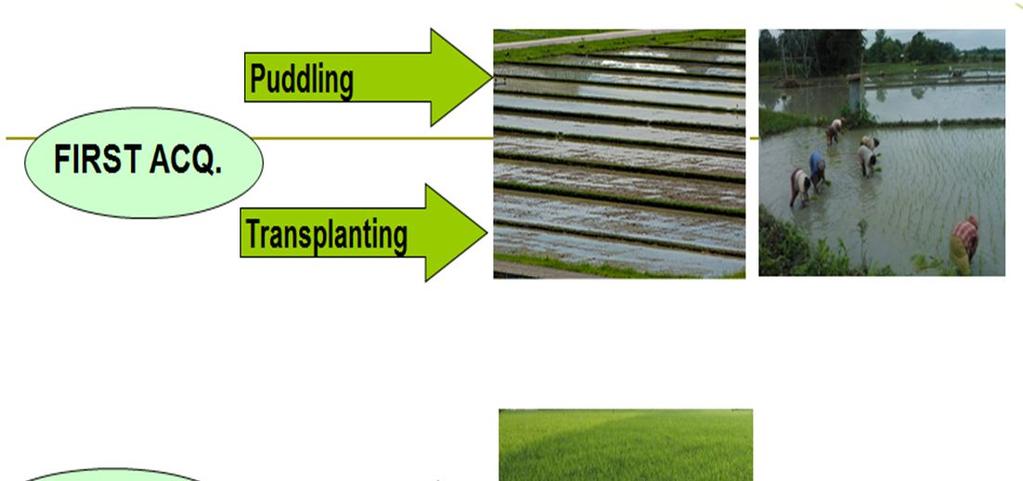
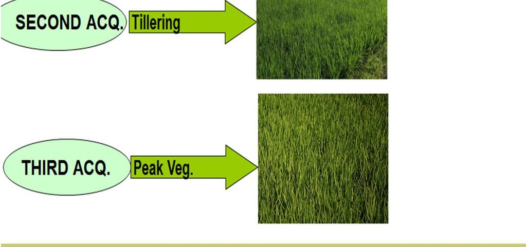
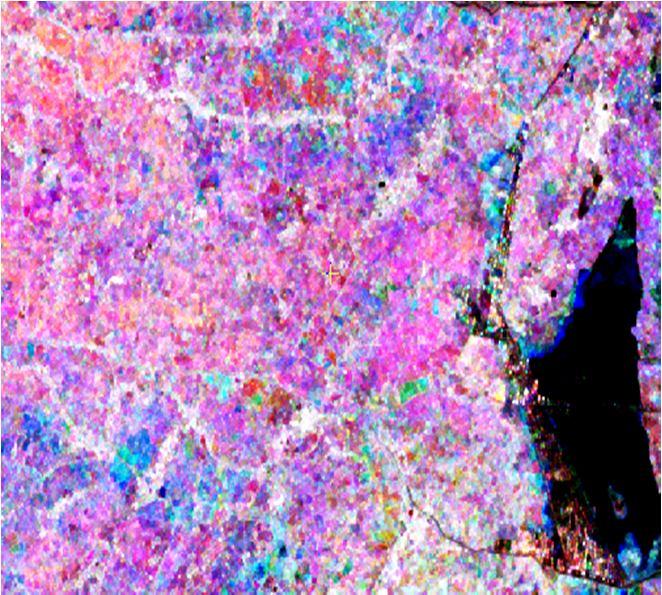
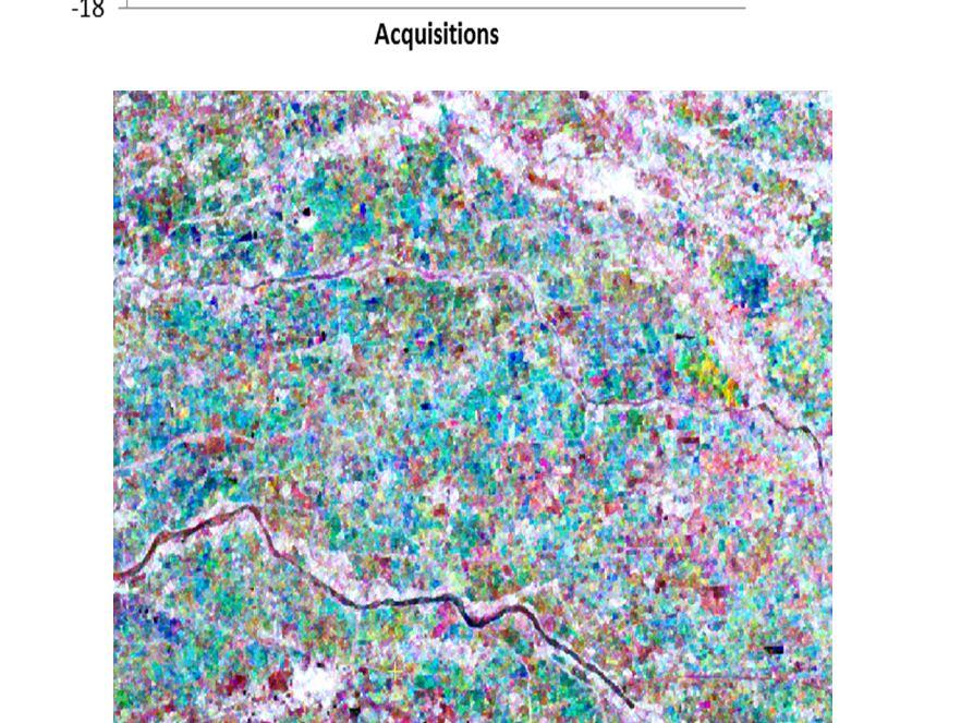
4 Satellite Data Radarsat-2 and RISAT-1Swath Coverage's over India Satellit e Radars at-2 Sens or Scan SAR Narro w B RISAT-1 MRS mode Sentine l -1 A Resol ution Swath Spectral Bands used 25m 300 km C band SAR HH Polarizat ion data 18m 115km C Band SAR HH Polarizat ion data SAR 20m 250 km C Band VV Polarizat ion SAR data Sets of data required at a time Multi-date Multi-date Multi-date Time Period Kharif Season (May to July) for Punjab, Haryana and (June to September) for rest of the Study States, (October to January) for Tamil Nadu Rabi Season (January to March) for Rabi Paddy Crop Kharif Rice No. of Study States State to Nation (% Area Contributio n) State to Nation (% Production Contributio n)
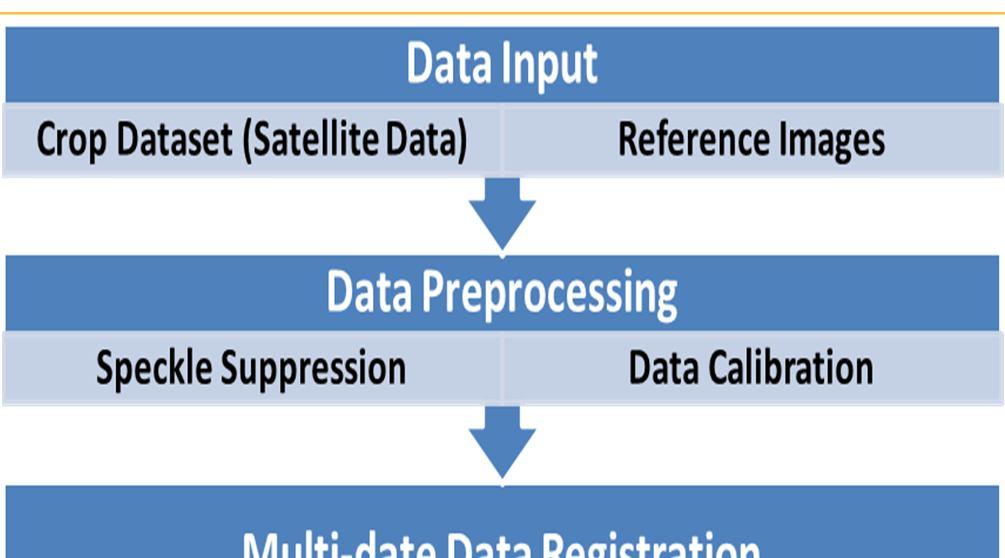
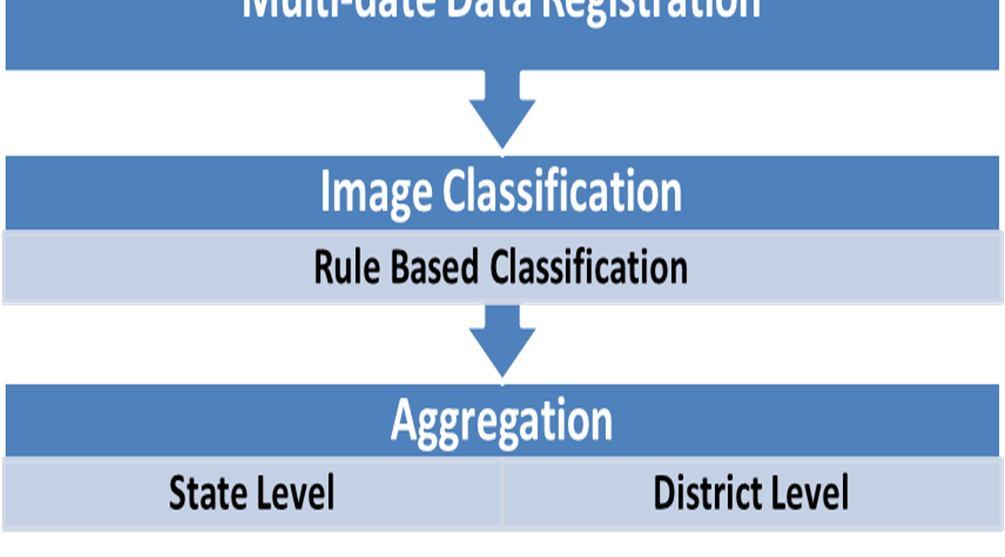
5 Methodology


6 What can be done from SAR data for Rice? Acreage Estimation

7
8 Acreage Estimation
 and Production (Right) using SAR")
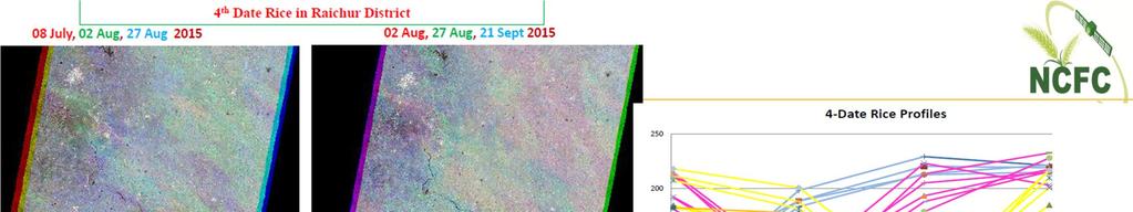
9 Acreage Estimation District wise Kharif Rice Area (left) and Production (Right) using SAR data


10 Acreage Estimation State wise Rice Area and Production using SAR data for Kharif Rice in India from to
11 Biomass Estimation Mean TP vs Frequency and Normalized age vs Biomass for Bihar Source: SAC, ISRO
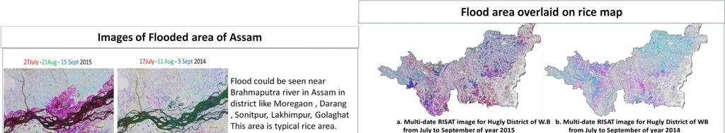
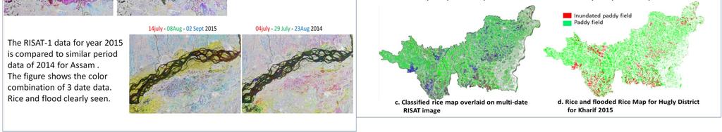
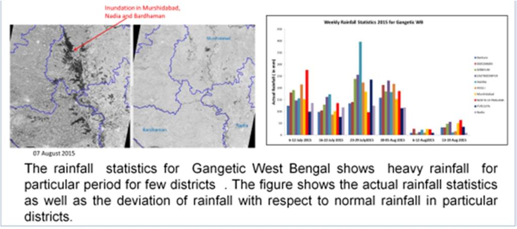
12 Area estimation during Flood


13 Area estimation during Flood Rice-Flooded Area Assessment, post-phailin Cyclone in Odisha State, October, 2013


 Source: NADAMS Report")

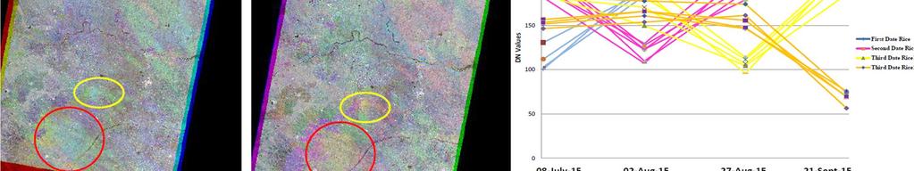
14 Area estimation during Drought GT Used Number of GT: 93 GT Period : 03 to 21-Sept-15 Seasonal Rainfall of Telangana upto 30/09/15 (Source: Source: NADAMS Report Nizamabad district in Telangana State showing reduction in rice area
, if available Classification into 4-6 classes,")

15 CCE Planning Generation of crop specific map using SAR data and ground truth NDVI computation for specific cropped area. Integration with other parameters (remote sensing, soil, weather), if available Classification into 4-6 classes, based on the variability existing Select CCE points randomly within each stratum Overlay the village boundary on the CCE locations Prepare a list of CCE points, along with the geographical coordinates, village (and block and district names)


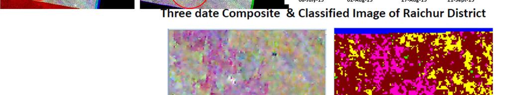
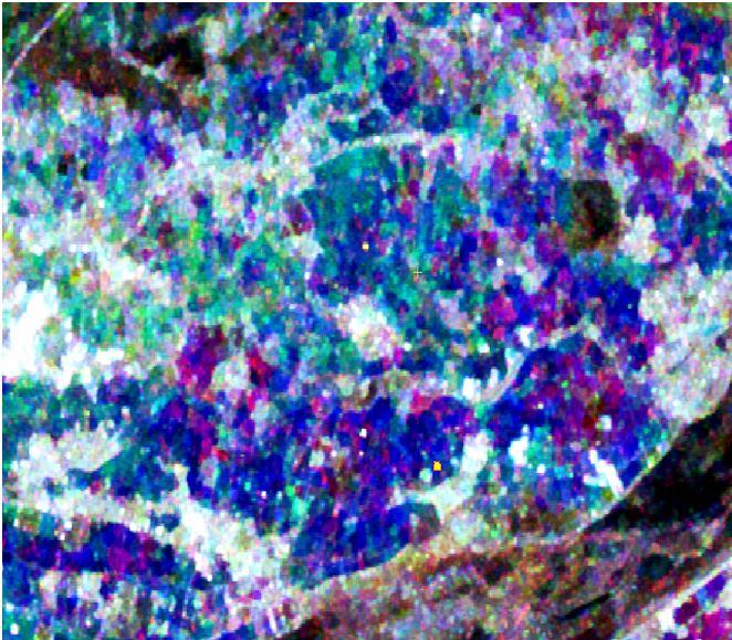
16 Crop Map Crop map for Odisha and West Bengal for Kharif paddy using RISAT-1 data from June 25 to September 10, 2016
17 Validation Data Source: FASAL and DAC&FW
18 Future Scope Methodology needs to be developed for more crops (Cotton, Maize etc.) grown in Kharif Season using SAR data. Farm level/ Village level crop area/loss assessment using High Resolution SAR (Sentinel, 10 m in every 5 days) data. Improved data frequency and resolution will definitely improve the biomass estimation accuracy. Further research needed for crop parameter retrieval (biomass, LAI, Phenology, Yield) from SAR.
19 Acknowledgment Organizations Indian Space Research Organization Department of Agriculture, Cooperation & Farmers Welfare India Meteorological Department Institute of Economic Growth State Agriculture Departments State Remote Sensing Centres Team Members from MNCFC Team Dr. Shalini Saxena Mr. Sunil Kumar Dubey Mr. Kanwar Vivek Singh Mr Akhilesh Porwal Mr Rajat Saxena Mr Santosh Kumar Dr. Varunika Jain Mr Ashutosh Kumar Gavli This work has been done under FASAL project of DAC&FW. THANK YOU
W E E K L Y MONSOON INSIGHT
 W E E K L Y MONSOON INSIGHT 08 th July 2016 Indian Monsoon Dynamics Recent Weather Development India received 35% surplus rainfall in the week ended 6 July with all regions recording above-normal rainfall
Probability models for weekly rainfall at Thrissur
 Journal of Tropical Agriculture 53 (1) : 56-6, 015 56 Probability models for weekly rainfall at Thrissur C. Laly John * and B. Ajithkumar *Department of Agricultural Statistics, College of Horticulture,
O.I.H GOVERNMENT OF INDIA MINISTRY OF AGRICULTURE AND FARMERS WELFARE DEPARTMENT OF AGRICULTURE, COOPERATION AND FARMERS WELFARE
 O.I.H GOVERNMENT OF INDIA MINISTRY OF AGRICULTURE AND WELFARE DEPARTMENT OF AGRICULTURE, COOPERATION AND WELFARE 810. SHRI R. DHRUVA NARAYANA: SHRI RAVINDRA KUMAR PANDEY: DR. UDIT RAJ: SHRI DALPAT SINGH
Date of. Issued by (AICRPAM), & Earth System
, & Earth System") National Agromet Advisory Service Bulletin Based on Extended Range Weather Forecast (ERFS) Validity: 29 September 12 October 2017 Date of Issue: 29 September 2017 Issued by Indian Council of Agricultural
National Agromet Advisory Service Bulletin Based on Extended Range Weather Forecast (ERFS) Validity: 29 September 12 October 2017 Date of Issue: 29 September 2017 Issued by Indian Council of Agricultural
Leveraging Sentinel-1 time-series data for mapping agricultural land cover and land use in the tropics
 Leveraging Sentinel-1 time-series data for mapping agricultural land cover and land use in the tropics Caitlin Kontgis caitlin@descarteslabs.com @caitlinkontgis Descartes Labs Overview What is Descartes
DROUGHT RISK EVALUATION USING REMOTE SENSING AND GIS : A CASE STUDY IN LOP BURI PROVINCE
 DROUGHT RISK EVALUATION USING REMOTE SENSING AND GIS : A CASE STUDY IN LOP BURI PROVINCE K. Prathumchai, Kiyoshi Honda, Kaew Nualchawee Asian Centre for Research on Remote Sensing STAR Program, Asian Institute
Indian Earth Observation Programme
 Indian Earth Observation Programme Dr. Jai Singh Parihar Dy. Director Remote Sensing Applications Area (RESA) Space Applications Centre (ISRO) Ahmedabad 380 015 India jsparihar@sac.isro.gov.in Presentation
Effect of rainfall and temperature on rice yield in Puri district of Odisha in India
 2018; 7(4): 899-903 ISSN (E): 2277-7695 ISSN (P): 2349-8242 NAAS Rating: 5.03 TPI 2018; 7(4): 899-903 2018 TPI www.thepharmajournal.com Received: 05-02-2018 Accepted: 08-03-2018 A Baliarsingh A Nanda AKB
O.I.H. GOVERNMENT OF INDIA MINISTRY OF AGRICULTURE AND FARMERS WELFARE DEPARTMENT OF AGRICULTURE, COOPERATION AND FARMERS WELFARE
 O.I.H. GOVERNMENT OF INDIA MINISTRY OF AGRICULTURE AND FARMERS WELFARE DEPARTMENT OF AGRICULTURE, COOPERATION AND FARMERS WELFARE 185. SHRI DEVJI M. PATEL: LOK SABHA UNSTARRED QUESTION NO.185 TO BE ANSWERED
Indian National (Weather) SATellites for Agrometeorological Applications
 SATellites for Agrometeorological Applications") Indian National (Weather) SATellites for Agrometeorological Applications Bimal K. Bhattacharya Agriculture-Terrestrial Biosphere- Hydrology Group Space Applications Centre (ISRO) Ahmedabad 380015, India
Indian National (Weather) SATellites for Agrometeorological Applications Bimal K. Bhattacharya Agriculture-Terrestrial Biosphere- Hydrology Group Space Applications Centre (ISRO) Ahmedabad 380015, India
Water Resource & Management Strategies
 Water Resource & Management Strategies National Conference on Integrated Water Resource Management for enhancing Farmers' Income March 22, 2017, Hotel Park, New Delhi Nalin Rawal Chief Business head Agribusiness
NPTEL. NOC:Weather Forecast in Agriculture and Agroadvisory (WF) - Video course. Agriculture. COURSE OUTLINE
 - Video course. Agriculture. COURSE OUTLINE") NPTEL Syllabus NOC:Weather Forecast in Agriculture and Agroadvisory (WF) - Video course COURSE OUTLINE Week Topics 1 a. Basic aspect of atmosphere, climate, weather Definition on atmosphere role of atmosphere
NPTEL Syllabus NOC:Weather Forecast in Agriculture and Agroadvisory (WF) - Video course COURSE OUTLINE Week Topics 1 a. Basic aspect of atmosphere, climate, weather Definition on atmosphere role of atmosphere
Long Range Forecast Update for 2014 Southwest Monsoon Rainfall
 Earth System Science Organization (ESSO) Ministry of Earth Sciences (MoES) India Meteorological Department PRESS RELEASE New Delhi, 9 June 2014 Long Update for 2014 Southwest Monsoon Rainfall HIGHLIGHTS
GEO Joint Experiment for Crop Assessment and Monitoring (JECAM): 2014 Site Progress Report
: 2014 Site Progress Report") GEO Joint Experiment for Crop Assessment and Monitoring (JECAM): JECAM Test Site Name: China - Guangdong 2014 Site Progress Report Team Leader and Members: Prof Wu Bingfang (Leader), Jiratiwan Kruasilp,
GEO Joint Experiment for Crop Assessment and Monitoring (JECAM): JECAM Test Site Name: China - Guangdong 2014 Site Progress Report Team Leader and Members: Prof Wu Bingfang (Leader), Jiratiwan Kruasilp,
Summary and Conclusions
 241 Chapter 10 Summary and Conclusions Kerala is situated in the southern tip of India between 8 15 N and 12 50 N latitude and 74 50 E and 77 30 E longitude. It is popularly known as Gods own country.
NAKSHATRA BASED RAINFALL ANALYSIS AND ITS IMPACT ON CROPS DURING MONSOON SEASON AT MANDYA DISTRICT
 International Journal of Current Agricultural Research, Vol. 4, No. 1, PP. 139-144 October 215 http://www.journalagri.com Full Length Research Article NAKSHATRA BASED RAINFALL ANALYSIS AND ITS IMPACT ON
International Journal of Scientific Research and Reviews
 Case Study Available online www.ijsrr.org ISSN: 2279 0543 International Journal of Scientific Research and Reviews Study on the Pattern of Land Use /Land Cover Change in Sonipat District of NCR, A Block
RESEARCH NOTE Changing Dew Patterns in Anantapur District, Andhra Pradesh: A Generalistic Observation INTRODUCTION
 RESEARCH NOTE Changing Dew Patterns in Anantapur District, Andhra Pradesh: A Generalistic Observation R.V. Rama Mohan* I INTRODUCTION Ind. Jn. of Agri. Econ. Vol.67, No.4, Oct.-Dec. 212 Anantapur district
Chapter 2 Drought Hazard in Bihar
 Chapter 2 Drought Hazard in Bihar 2.1 Introduction Drought occurs when a region faces a deficiency in its water supply either surface or underground for an extended period of months or years, due to consistent
Frequency analysis of rainfall deviation in Dharmapuri district in Tamil Nadu
 Indian Journal of Geo Marine Sciences Vol.46 (8), August 217, pp. 171-1714 Frequency analysis of rainfall deviation in Dharmapuri district in Tamil Nadu V. Rajendran 1* & R. Venkatasubramani 2 1 Department
Rice Monitoring using Simulated Compact SAR. Kun Li, Yun Shao Institute of Remote Sensing and Digital Earth
 Rice Monitoring using Simulated Compact SAR Kun Li, Yun Shao Institute of Remote Sensing and Digital Earth Outlines Introduction Test site and data Results Rice type discrimination Rice phenology retrieval
Development of regression models in ber genotypes under the agroclimatic conditions of south-western region of Punjab, India
 Indian J. Agric. Res., 49 (3) 2015: 260-264 Print ISSN:0367-8245 / Online ISSN:0976-058X AGRICULTURAL RESEARCH COMMUNICATION CENTRE www.arccjournals.com/www.ijarjournal.com Development of regression models
ORIGINAL IN HINDI GOVERNMENT OF INDIA MINISTRY OF CONSUMER AFFAIRS, FOOD & PUBLIC DISTRIBUTION DEPARTMENT OF FOOD AND PUBLIC DISTRIBUTION
 ORIGINAL IN HINDI GOVERNMENT OF INDIA MINISTRY OF CONSUMER AFFAIRS, FOOD & PUBLIC DISTRIBUTION DEPARTMENT OF FOOD AND PUBLIC DISTRIBUTION LOK SABHA UNSTARRED QUESTION NO. 4122 TO BE ANSWERED ON 20 TH MARCH,
Rainfall is the major source of water for
 RESEARCH PAPER: Assessment of occurrence and frequency of drought using rainfall data in Coimbatore, India M. MANIKANDAN AND D.TAMILMANI Asian Journal of Environmental Science December, 2011 Vol. 6 Issue
PROJECT REPORT (ASL 720) CLOUD CLASSIFICATION
 CLOUD CLASSIFICATION") PROJECT REPORT (ASL 720) CLOUD CLASSIFICATION SUBMITTED BY- PRIYANKA GUPTA 2011CH70177 RINI KAPOOR 2011CH70179 INDIVIDUAL CONTRIBUTION- Priyanka Gupta- analysed data of region considered in India (West:80,
PROJECT REPORT (ASL 720) CLOUD CLASSIFICATION SUBMITTED BY- PRIYANKA GUPTA 2011CH70177 RINI KAPOOR 2011CH70179 INDIVIDUAL CONTRIBUTION- Priyanka Gupta- analysed data of region considered in India (West:80,
Agricultural land-use from space. David Pairman and Heather North
 Agricultural land-use from space David Pairman and Heather North Talk Outline Motivation Challenges Different approach Paddock boundaries Classifications Examples Accuracy Issues Data sources Future possibilities
Outline. Remote Sensing, GIS and DEM Applications for Flood Monitoring. Introduction. Satellites and their Sensors used for Flood Mapping
 Outline Remote Sensing, GIS and DEM Applications for Flood Monitoring Prof. D. Nagesh Kumar Chairman, Centre for Earth Sciences Professor, Dept. of Civil Engg. Indian Institute of Science Bangalore 560
ISPRS Archives XXXVIII-8/W3 Workshop Proceedings: Impact of Climate Change on Agriculture
 DERIVING PHENOLOGY METRICS AND THEIR TRENDS USING TIMES SERIES OF AVHRR-NDVI DATA Vinay Sehgal a, *, Surabhi Jain b and Pramod Aggarwal b a Agricultural Physics, Indian Agricultural Research Institute,
DROUGHT ASSESSMENT USING SATELLITE DERIVED METEOROLOGICAL PARAMETERS AND NDVI IN POTOHAR REGION
 DROUGHT ASSESSMENT USING SATELLITE DERIVED METEOROLOGICAL PARAMETERS AND NDVI IN POTOHAR REGION Researcher: Saad-ul-Haque Supervisor: Dr. Badar Ghauri Department of RS & GISc Institute of Space Technology
INTERNATIONAL JOURNAL OF PURE AND APPLIED RESEARCH IN ENGINEERING AND TECHNOLOGY
 INTERNATIONAL JOURNAL OF PURE AND APPLIED RESEARCH IN ENGINEERING AND TECHNOLOGY A PATH FOR HORIZING YOUR INNOVATIVE WORK FITTING STATISTICAL DISTRUBTIONS FOR MAXIMUM DAILY RAINFALL AT GKVK STATION K.
Rainfall variation and frequency analysis study of Salem district Tamil Nadu
 Indian Journal of Geo Marine Sciences Vol. 46 (1), January 217, pp. 213-218 Rainfall variation and frequency analysis study of Salem district Tamil Nadu Arulmozhi.S 1* & Dr. Prince Arulraj.G 2 1 Department
Journal of Pharmacognosy and Phytochemistry 2017; 6(4): Sujitha E and Shanmugasundaram K
: Sujitha E and Shanmugasundaram K") 2017; 6(4): 452-457 E-ISSN: 2278-4136 P-ISSN: 2349-8234 JPP 2017; 6(4): 452-457 Received: 01-05-2017 Accepted: 02-06-2017 Sujitha E Research Scholar, Department of Soil and Water Conservation Engineering,
2017; 6(4): 452-457 E-ISSN: 2278-4136 P-ISSN: 2349-8234 JPP 2017; 6(4): 452-457 Received: 01-05-2017 Accepted: 02-06-2017 Sujitha E Research Scholar, Department of Soil and Water Conservation Engineering,
Development of Agrometeorological Models for Estimation of Cotton Yield
 DOI: 10.5958/2349-4433.2015.00006.9 Development of Agrometeorological Models for Estimation of Cotton Yield K K Gill and Kavita Bhatt School of Climate Change and Agricultural Meteorology Punjab Agricultural
Applications of yield monitoring systems and agricultural statistics in agricultural (re)insurance
insurance") Image: used under license from shutterstock.com Applications of yield monitoring systems and agricultural statistics in agricultural (re)insurance 18 October 2018 Ernst Bedacht Agenda Introduction 1. Munich
Image: used under license from shutterstock.com Applications of yield monitoring systems and agricultural statistics in agricultural (re)insurance 18 October 2018 Ernst Bedacht Agenda Introduction 1. Munich
DECISION MAKING IN AGRICULTURE BASED ON LAND SUITABILITY SPATIAL DATA ANALYSIS APPROACH
 DECISION MAKING IN AGRICULTURE BASED ON LAND SUITABILITY SPATIAL DATA ANALYSIS APPROACH 1 M. PARIMALA, 2 DAPHNE LOPEZ 1 Asst Prof., School of Information Technology & Engineeirng, VIT University 2 Prof.,
Rainfall variation and frequency analysis study in Dharmapuri district, India
 Indian Journal of Geo Marine Sciences Vol. 45 (11), November 216, pp. 156-1565 Rainfall variation and frequency analysis study in Dharmapuri district, India V. Rajendran 1*, R. Venkatasubramani 2 & G.
Fish Pond. Old Secretariate. Shaheed Smarak
 Fish Pond Old Secretariate Shaheed Smarak HOW SATELLITE SCANS EARTH. Rajbhawan area viewed by IKONOS 1 meter sensor Very high resolution (40 cm) Orbi-Image data Higher the resolution better the geometric
CHANGE DETECTION USING REMOTE SENSING- LAND COVER CHANGE ANALYSIS OF THE TEBA CATCHMENT IN SPAIN (A CASE STUDY)
") CHANGE DETECTION USING REMOTE SENSING- LAND COVER CHANGE ANALYSIS OF THE TEBA CATCHMENT IN SPAIN (A CASE STUDY) Sharda Singh, Professor & Programme Director CENTRE FOR GEO-INFORMATICS RESEARCH AND TRAINING
CHANGE DETECTION USING REMOTE SENSING- LAND COVER CHANGE ANALYSIS OF THE TEBA CATCHMENT IN SPAIN (A CASE STUDY) Sharda Singh, Professor & Programme Director CENTRE FOR GEO-INFORMATICS RESEARCH AND TRAINING
VILLAGE INFORMATION SYSTEM (V.I.S) FOR WATERSHED MANAGEMENT IN THE NORTH AHMADNAGAR DISTRICT, MAHARASHTRA
 FOR WATERSHED MANAGEMENT IN THE NORTH AHMADNAGAR DISTRICT, MAHARASHTRA") VILLAGE INFORMATION SYSTEM (V.I.S) FOR WATERSHED MANAGEMENT IN THE NORTH AHMADNAGAR DISTRICT, MAHARASHTRA Abstract: The drought prone zone in the Western Maharashtra is not in position to achieve the agricultural
VILLAGE INFORMATION SYSTEM (V.I.S) FOR WATERSHED MANAGEMENT IN THE NORTH AHMADNAGAR DISTRICT, MAHARASHTRA Abstract: The drought prone zone in the Western Maharashtra is not in position to achieve the agricultural
Traditional method of rainfall prediction through Almanacs in Ladakh
 Indian Journal of Traditional Knowledge Vol. 5(1), January 2006, pp. 145-150 Traditional method of rainfall through Almanacs in Ladakh D Angchok* & V K Dubey Division of Agricultural Extension, Indian
Stochastic Modelling of Daily Rainfall at Naogaon District in Bangladesh: A Comparative Study
 Volume-3, Issue-1, January 2011, ISSN No.1998-7889 Eastern University Journal Stochastic Modelling of Daily Rainfall at Naogaon District in Bangladesh: A Comparative Study Abstract M. A. B. Barkotulla
Introduction to Satellite Derived Vegetation Indices
 Introduction to the Use of Geospatial Information Technology for Drought Risk Management 13-17 November, 2017 Tonle Bassac II Restaurant, Phnom Penh, Cambodia Introduction to Satellite Derived Vegetation
Effect of Weather Parameters on Population Dynamics of Paddy Pests
 International Journal of Current Microbiology and Applied Sciences ISSN: 2319-7706 Volume 6 Number 10 (2017) pp. 2049-2053 Journal homepage: http://www.ijcmas.com Original Research Article https://doi.org/10.20546/ijcmas.2017.610.243
CROP COMBINATION REGION: A SPATIO-TEMPORAL ANALYSIS OF HARYANA: &
 212 CROP COMBINATION REGION: A SPATIO-TEMPORAL ANALYSIS OF HARYANA:1990-93&2009-12 Subhash chander 1 Abstract Agriculture being a basic activity plays a vital role in Indian economy. The studies of crop
Development of the Regression Model to Predict Pigeon Pea Yield Using Meteorological Variables for Marathwada Region (Maharashtra)
") Available online at www.ijpab.com Singh et al Int. J. Pure App. Biosci. 5 (6): 1627-1631 (2017) ISSN: 2320 7051 DOI: http://dx.doi.org/10.18782/2320-7051.5445 ISSN: 2320 7051 Int. J. Pure App. Biosci.
Available online at www.ijpab.com Singh et al Int. J. Pure App. Biosci. 5 (6): 1627-1631 (2017) ISSN: 2320 7051 DOI: http://dx.doi.org/10.18782/2320-7051.5445 ISSN: 2320 7051 Int. J. Pure App. Biosci.
ALL INDIA WEATHER SUMMARY AND FORECAST BULLETIN
 Sunday 22 April 2018 NIGHT Time of Issue: 2000 hours IST ALL INDIA WEATHER SUMMARY AND FORECAST BULLETIN Significant Weather Features The ongoing fairly widespread rainfall activity with isolated thunder
Analytical Report. Drought in Sri Lanka January2017 ERCC Analytical Team and JRC Drought Team 26 January Map
 1. Map 2. Situation analysis Sri Lanka 1 is currently experiencing a severe drought. This drought situation has been caused by a severe lack of rainfall during the last second Inter-monsoon season (IM2)
3. HYDROMETEROLOGY. 3.1 Introduction. 3.2 Hydro-meteorological Aspect. 3.3 Rain Gauge Stations
 3. HYDROMETEROLOGY 3.1 Introduction Hydrometeorology is a branch of meteorology and hydrology that studies the transfer of water and energy between the land surface and the lower atmosphere. Detailed hydrological
MODELING RUNOFF RESPONSE TO CHANGING LAND COVER IN PENGANGA SUBWATERSHED, MAHARASHTRA
 MODELING RUNOFF RESPONSE TO CHANGING LAND COVER IN PENGANGA SUBWATERSHED, MAHARASHTRA Abira Dutta Roy*, S.Sreekesh** *Research Scholar, **Associate Professor Centre for the Study of Regional Development,
To Predict Rain Fall in Desert Area of Rajasthan Using Data Mining Techniques
 To Predict Rain Fall in Desert Area of Rajasthan Using Data Mining Techniques Peeyush Vyas Asst. Professor, CE/IT Department of Vadodara Institute of Engineering, Vadodara Abstract: Weather forecasting
10 emergency observation requests were successfully processed during the period
 ISRO s Inputs for the Sentinel Asia DPN and JPT meeting being held during 13-16, 16, November 2012 November 2012 Sentinel Asia Activity Spectrum - A dedicated Sentinel Asia server established at NRSC,
Advanced Image Analysis in Disaster Response
 Advanced Image Analysis in Disaster Response Creating Geographic Knowledge Thomas Harris ITT The information contained in this document pertains to software products and services that are subject to the
Study of Hydrometeorology in a Hard Rock Terrain, Kadirischist Belt Area, Anantapur District, Andhra Pradesh
 Open Journal of Geology, 2012, 2, 294-300 http://dx.doi.org/10.4236/ojg.2012.24028 Published Online October 2012 (http://www.scirp.org/journal/ojg) Study of Hydrometeorology in a Hard Rock Terrain, Kadirischist
Influence of Micro-Climate Parameters on Natural Vegetation A Study on Orkhon and Selenge Basins, Mongolia, Using Landsat-TM and NOAA-AVHRR Data
 Cloud Publications International Journal of Advanced Remote Sensing and GIS 2013, Volume 2, Issue 1, pp. 160-172, Article ID Tech-102 ISSN 2320-0243 Research Article Open Access Influence of Micro-Climate
Key Finding: Long Term Trend During 2014: Rain in Indian Tradition Measuring Rain
 Chapter 34 RAINFALL Key Finding: Long Term Trend Despite of theories suggesting increase in rainfall in Asian Region due to global warming, no significant trend has been observed at all India level (confirmed
GOVERNMENT OF INDIA MINISTRY OF HEALTH AND FAMILY WELFARE DEPARTMENT OF HEALTH AND FAMILY WELFARE
 GOVERNMENT OF INDIA MINISTRY OF HEALTH AND FAMILY WELFARE DEPARTMENT OF HEALTH AND FAMILY WELFARE LOK SABHA STARRED QUESTION NO. 183 TO BE ANSWERED ON THE 29 TH JULY, 2016 VECTOR BORNE DISEASES *183. SHRI
Chapter-3 GEOGRAPHICAL LOCATION, CLIMATE AND SOIL CHARACTERISTICS OF THE STUDY SITE
 Chapter-3 GEOGRAPHICAL LOCATION, CLIMATE AND SOIL CHARACTERISTICS OF THE STUDY SITE Chapter-3 GEOGRAPHICAL LOCATION, CLIMATE AND SOIL CHARACTERISTICS OF THE STUDY SITE Assam, the eastern most state of
ALL INDIA WEATHER SUMMARY AND FORECAST BULLETIN
 Tuesday 08 May 2018 MID DAY Time of Issue: 1345 hours IST ALL INDIA WEATHER SUMMARY AND FORECAST BULLETIN Significant Weather Features Under the influence of the present Western Disturbance over Jammu
BOTSWANA AGROMETEOROLOGICAL MONTHLY
 Depart. Of Meteorological Services Agro-met Office P.O. Box 10100, Gaborone Tel: 3612200 Fax: 3956282/140 Corner Maaloso- Metsimothaba Road Gaborone Village Highlights: Very wet to extremely wet conditions
Seasonal Hydrological Forecasting in the Berg Water Management Area of South Africa
 Seasonal Hydrological Forecasting in the Berg Water Management Area of South Africa Trevor LUMSDEN and Roland SCHULZE University of KwaZulu-Natal, South Africa OUTLINE Introduction Objectives Study Area
Plantations Mapping of Dabwali, Rania and Ellenabad blocks of Sirsa District Using on Screen Visual Interpretation Approach on WV-2 Data
 s Mapping of Dabwali, Rania and Ellenabad blocks of Sirsa District Using on Screen Visual Interpretation Approach on WV-2 Data Savita 1, Veena 2, Reetu Sharma 3 Haryana Space Applications Centre (HARSAC),
SMAP and SMOS Integrated Soil Moisture Validation. T. J. Jackson USDA ARS
 SMAP and SMOS Integrated Soil Moisture Validation T. J. Jackson USDA ARS Perspective Linkage of SMOS and SMAP soil moisture calibration and validation will have short and long term benefits for both missions.
Use of Geospatial data for disaster managements
 Use of Geospatial data for disaster managements Source: http://alertsystemsgroup.com Instructor : Professor Dr. Yuji Murayama Teaching Assistant : Manjula Ranagalage What is GIS? A powerful set of tools
Weather and climate outlooks for crop estimates
 Weather and climate outlooks for crop estimates CELC meeting 2016-04-21 ARC ISCW Observed weather data Modeled weather data Short-range forecasts Seasonal forecasts Climate change scenario data Introduction
Spatial and Temporal Analysis of Rainfall Variation in Yadalavagu Hydrogeological unit using GIS, Prakasam District, Andhra Pradesh, India
 International Research Journal of Environment Sciences ISSN 2319 1414 Spatial and Temporal Analysis of Rainfall Variation in Yadalavagu Hydrogeological unit using GIS, Prakasam District, Andhra Pradesh,
MARKOV CHAIN MODEL FOR PROBABILITY OF DRY, WET DAYS AND STATISTICAL ANALISIS OF DAILY RAINFALL IN SOME CLIMATIC ZONE OF IRAN
 30T r30t MARKOV CHAIN MODEL FOR PROBABILITY OF DRY, WET DAYS AND STATISTICAL ANALISIS OF DAILY RAINFALL IN SOME CLIMATIC ZONE OF IRAN N. SHAHRAKI 1, B. BAKHTIARI 2, M. M. AHMADI 2 ABSTRACT- Markov chain
Seasonal Activity of Sogatella furcifera H.,Cnaphalocropcis medinalis G. and Mythimna separata W. in Relation to Weather Parameters in Central India
 Seasonal Activity of Sogatella furcifera H.,Cnaphalocropcis medinalis G. and Mythimna separata W. in Relation to Weather Parameters in Central India Amit Kumar Sharma, Swati Barche And P. K. Mishra JNKVV,
CHAPTER VII FULLY DISTRIBUTED RAINFALL-RUNOFF MODEL USING GIS
 80 CHAPTER VII FULLY DISTRIBUTED RAINFALL-RUNOFF MODEL USING GIS 7.1GENERAL This chapter is discussed in six parts. Introduction to Runoff estimation using fully Distributed model is discussed in first
Indian Earth Observations Satellites and Applications - Reaping Social Benefits
 Indian Earth Observations Satellites and Applications - Reaping Social Benefits 1. Introduction V.S. Hegde Antrix Corporation Limited, Bangalore With humble beginning in early 60s, the Indian Space Programme
Abstract. TECHNOFAME- A Journal of Multidisciplinary Advance Research. Vol.2 No. 2, (2013) Received: Feb.2013; Accepted Oct.
 Received: Feb.2013; Accepted Oct.") Vol.2 No. 2, 83-87 (2013) Received: Feb.2013; Accepted Oct. 2013 Landuse Pattern Analysis Using Remote Sensing: A Case Study of Morar Block, of Gwalior District, M.P. Subhash Thakur 1 Akhilesh Singh 2
Vol.2 No. 2, 83-87 (2013) Received: Feb.2013; Accepted Oct. 2013 Landuse Pattern Analysis Using Remote Sensing: A Case Study of Morar Block, of Gwalior District, M.P. Subhash Thakur 1 Akhilesh Singh 2
Land Use and Land Cover Mapping and Change Detection in Jind District of Haryana Using Multi-Temporal Satellite Data
 Land Use and Land Cover Mapping and Change Detection in Jind District of Haryana Using Multi-Temporal Satellite Data Ravindra Prawasi, M.P. Sharma, T. P. Babu, Om Pal, Saroj, Kirti Yadav, R.S.Hooda Abstract
Dry spell analysis for effective water management planning
 www.ijaser.com 2012 by the authors Licensee IJASER- Under Creative Commons License 3.0 editorial@ijaser.com Research article ISSN 2277 9442 Dry spell analysis for effective water management planning Kandasamy
Best Fit Probability Distributions for Monthly Radiosonde Weather Data
 Best Fit Probability Distributions for Monthly Radiosonde Weather Data Athulya P. S 1 and K. C James 2 1 M.Tech III Semester, 2 Professor Department of statistics Cochin University of Science and Technology
Assessment of Ground Water in a Part of Coastal West Bengal using Geo-Electrical Method
 Vol. 13, No. 2, pp. 203-210 (2013) Journal of Agricultural Physics ISSN 0973-032X http://www.agrophysics.in Research Article Assessment of Ground Water in a Part of Coastal West Bengal using Geo-Electrical
An Approach to Analyse the Agriculture Acreage and Estimate Production
 Indian Journal of Science and Technology, Vol 9(28), DOI: 10.17485/ijst/2016/v9i28/98393, July 2016 ISSN (Print) : 0974-6846 ISSN (Online) : 0974-5645 An Approach to Analyse the Agriculture Acreage and
CHAPTER 4 METHODOLOGY
 71 CHAPTER 4 METHODOLOGY 4.1 GENERAL Drought, a vague phenomenon, has been defined and analyzed in various ways. Drought assessment involves analysis of spatially and temporally varying water related data.
Analysis of Rainfall and Other Weather Parameters under Climatic Variability of Parbhani ( )
") International Journal of Current Microbiology and Applied Sciences ISSN: 2319-7706 Volume 7 Number 06 (2018) Journal homepage: http://www.ijcmas.com Original Research Article https://doi.org/10.20546/ijcmas.2018.706.295
International Journal of Current Microbiology and Applied Sciences ISSN: 2319-7706 Volume 7 Number 06 (2018) Journal homepage: http://www.ijcmas.com Original Research Article https://doi.org/10.20546/ijcmas.2018.706.295
Remote Sensing Geographic Information Systems Global Positioning Systems
 Remote Sensing Geographic Information Systems Global Positioning Systems Assessing Seasonal Vegetation Response to Drought Lei Ji Department of Geography University of Nebraska-Lincoln AVHRR-NDVI: July
The study of the impact of climate variability on Aman rice yield of Bangladesh
 The study of the impact of climate variability on Aman rice yield of Bangladesh Toma Rani Saha 1 and Dewan Abdul Quadir 2 Abstract An attempt has been made to investigate the relationship of climate variability
Joint Meeting of RA II WIGOS Project and RA V TT-SU on 11 October 2018 BMKG Headquarter Jakarta, Indonesia. Mrs. Sinthaly CHANTHANA
 Joint Meeting of RA II WIGOS Project and RA V TT-SU on 11 October 2018 BMKG Headquarter Jakarta, Indonesia Mrs. Sinthaly CHANTHANA Lao PDR Background Department of Meteorology and Hydrology ( DMH ) in
Land Use Land Cover Change in Active Flood Plain using Satellite Remote Sensing
 Jour. Agric. Physics, Vol. 8, pp. 22-28 (2008) Land Use Land Cover Change in Active Flood Plain using Satellite Remote Sensing GOPAL KUMAR, R.N. SAHOO, R.K. TOMAR, M. BHAVANARAYANA, V.K. GUPTA, C.S.RAO,
The Importance of Snowmelt Runoff Modeling for Sustainable Development and Disaster Prevention
 The Importance of Snowmelt Runoff Modeling for Sustainable Development and Disaster Prevention Muzafar Malikov Space Research Centre Academy of Sciences Republic of Uzbekistan Water H 2 O Gas - Water Vapor
USE OF GEOREFERENCE INFORMATION FOR DRM Arnob Bormdoi Research Associate, GIC
 USE OF GEOREFERENCE INFORMATION FOR DRM Arnob Bormdoi Research Associate, GIC CONTENTS INTRODUCTION THE IMPORTANCE OF SPATIAL INFORMATION CASE STUDIES SUMMARY INTRODUCTION The process of defining how raster
[Penumaka, 7(1): January-March 2017] ISSN Impact Factor
![[Penumaka, 7(1): January-March 2017] ISSN Impact Factor](/thumbs/95/124653515.jpg "[Penumaka, 7(1): January-March 2017] ISSN Impact Factor") INTERNATIONAL JOURNAL OF ENGINEERING SCIENCES &MANAGEMENT HYDROGEOMORPHOLOGY OF CHEVELLA BASIN, RANGA REDDY DISTRICT, TELANGANA STATE Penumaka Ramesh* 1 & Podila Sankara Pitchaiah 2 * 1&2 Department of
INTERNATIONAL JOURNAL OF ENGINEERING SCIENCES &MANAGEMENT HYDROGEOMORPHOLOGY OF CHEVELLA BASIN, RANGA REDDY DISTRICT, TELANGANA STATE Penumaka Ramesh* 1 & Podila Sankara Pitchaiah 2 * 1&2 Department of
CURRENT STATUS OF MONSOON Main Meteorological conditions of the last week (27August to 2 September)
") CURRENT STATUS OF MONSOON 2009 Main Meteorological conditions of the last week (27August to 2 September) Last week s low pressure area over Orissa and neighbourhood moved west-northwestwards across central
CURRENT STATUS OF MONSOON 2009 Main Meteorological conditions of the last week (27August to 2 September) Last week s low pressure area over Orissa and neighbourhood moved west-northwestwards across central
B.A. /B.Sc. (Honours) Course in Geography (Revised Syllabus) (W.e.f. from the Academic Session )
 Course in Geography (Revised Syllabus) (W.e.f. from the Academic Session )") B.A. /B.Sc. (Honours) Course in Geography (Revised Syllabus) (W.e.f. from the Academic Session 2016-2017) Part- II (Honours) (Full Marks: 200) Paper Group Marks Full Marks Paper IV: Climatology, Hydrology
B.A. /B.Sc. (Honours) Course in Geography (Revised Syllabus) (W.e.f. from the Academic Session 2016-2017) Part- II (Honours) (Full Marks: 200) Paper Group Marks Full Marks Paper IV: Climatology, Hydrology
Droughts are normal recurring climatic phenomena that vary in space, time, and intensity. They may affect people and agriculture at local scales for
 I. INTRODUCTION 1.1. Background Droughts are normal recurring climatic phenomena that vary in space, time, and intensity. They may affect people and agriculture at local scales for short periods or cover
ALL INDIA WEATHER SUMMARY AND FORECAST BULLETIN
 Saturday 21 April 2018 MORNING Time of Issue: 0800 hours IST ALL INDIA WEATHER SUMMARY AND FORECAST BULLETIN Significant Weather Features Isolated thunder squalls and hailstorms are very likely over Sub
OVERVIEW OF IMPROVED USE OF RS INDICATORS AT INAM. Domingos Mosquito Patricio
 OVERVIEW OF IMPROVED USE OF RS INDICATORS AT INAM Domingos Mosquito Patricio domingos.mosquito@gmail.com Introduction to Mozambique /INAM Introduction to AGRICAB/SPIRITS Objectives Material & Methods Results
Effective Utilization of Synthetic Aperture Radar (SAR) Imagery in Rapid Damage Assessment
 Imagery in Rapid Damage Assessment") Effective Utilization of Synthetic Aperture Radar (SAR) Imagery in Rapid Damage Assessment Case Study Pakistan Floods SUPARCO M. Maisam Raza, Ahmad H. Rabbani SEQUENCE Flood Monitoring using Satellite
Effective Utilization of Synthetic Aperture Radar (SAR) Imagery in Rapid Damage Assessment Case Study Pakistan Floods SUPARCO M. Maisam Raza, Ahmad H. Rabbani SEQUENCE Flood Monitoring using Satellite
Drought risk assessment using GIS and remote sensing: A case study of District Khushab, Pakistan
 15 th International Conference on Environmental Science and Technology Rhodes, Greece, 31 August to 2 September 2017 Drought risk assessment using GIS and remote sensing: A case study of District Khushab,
over the next three weeks could lower this estimate significantly. Near perfect conditions are needed to realize this projected yield.
 Peanuts across the V-C region experienced excessive rainfall in many areas as a result of Hurricane Florence. Rainfall was particularly heavy in southeastern North Carolina and northeastern South Carolina.
LAND USE AND LAND COVER ANALYSIS USING 8- BAND DATA: A CASE STUDY OF BELGAUM CITY AND ITS SURROUNDING.
 LAND USE AND LAND COVER ANALYSIS USING 8- BAND DATA: A CASE STUDY OF BELGAUM CITY AND ITS SURROUNDING. Mrs. Rita Basanna *, Dr. A.K. Wodeyar ** ABSTRACT Monitoring land-use change has become an important
CLASS XII GEOGRAPHY (029) SAMPLE QUESTION PAPER ( ) Time allowed - 3 Hrs. Max. Marks 70
 SAMPLE QUESTION PAPER ( ) Time allowed - 3 Hrs. Max. Marks 70") CLASS XII GEOGRAPHY (029) SAMPLE QUESTION PAPER (208-9) Time allowed - 3 Hrs. Max. Marks 70 General Instructions: There are 22 general questions. Questions No. 7 are very short-answer questions carrying
CLASS XII GEOGRAPHY (029) SAMPLE QUESTION PAPER (208-9) Time allowed - 3 Hrs. Max. Marks 70 General Instructions: There are 22 general questions. Questions No. 7 are very short-answer questions carrying
Comparison between Multitemporal and Polarimetric SAR Data for Land Cover Classification
 Downloaded from orbit.dtu.dk on: Sep 19, 2018 Comparison between Multitemporal and Polarimetric SAR Data for Land Cover Classification Skriver, Henning Published in: Geoscience and Remote Sensing Symposium,
A looming drought is manageable. Long-term changes to the monsoon might be catastrophic
 India s climate: Monsoon, or later The Economist 1 of 5 9/4/2012 10:29 PM India s climate Monsoon, or later A looming drought is manageable. Long-term changes to the monsoon might be catastrophic Jul 28th
Population dynamics of chiku moth, Nephopteryx eugraphella (Ragonot) in relation to weather parameters
 in relation to weather parameters") 2017; 5(4): 1040-1044 E-SSN: 2320-7078 P-SSN: 2349-6800 JEZS 2017; 5(4): 1040-1044 2017 JEZS Received: 12-05-2017 Accepted: 13-06-2017 HK Chaudhary RK Thumar MB Zala CC Patel Correspondence HK Chaudhary
2017; 5(4): 1040-1044 E-SSN: 2320-7078 P-SSN: 2349-6800 JEZS 2017; 5(4): 1040-1044 2017 JEZS Received: 12-05-2017 Accepted: 13-06-2017 HK Chaudhary RK Thumar MB Zala CC Patel Correspondence HK Chaudhary
Statistical Analysis of Temperature and Rainfall Trend in Raipur District of Chhattisgarh
 Current World Environment Vol. 10(1), 305-312 (2015) Statistical Analysis of Temperature and Rainfall Trend in Raipur District of Chhattisgarh R. Khavse*, R. Deshmukh, N. Manikandan, J. L Chaudhary and
AFP Surveillance Bulletin - India Report for week 1, ending 5 January 2019
 Jan-18 Feb-18 Mar-18 Apr-18 May-18 Jun-18 Jul-18 Aug-18 Sep-18 Oct-18 Nov-18 Dec-18 Jan-19 Table 1: cases by month of paralysis onset, last 13 months State/UT's Total cases in cases as on week 1, cases
STUDY OF CLIMATE VARIABILITY AND ITS CORRELATION WITH SUGARCANE YIELD OVER BAGALKOT USING REMOTE SENSING.
 STUDY OF CLIMATE VARIABILITY AND ITS CORRELATION WITH SUGARCANE YIELD OVER BAGALKOT USING REMOTE SENSING. 1 Shruti Y, 2 Hattarki Pooja, 3 K C Gouda, 4 P P Nageswara Rao. 1 Senior Research Fellow-UAS, GKVK,