CROP COMBINATION REGION: A SPATIO-TEMPORAL ANALYSIS OF HARYANA: &
|
|
|
- Merryl Wilkinson
- 5 years ago
- Views:
Transcription
1 212 CROP COMBINATION REGION: A SPATIO-TEMPORAL ANALYSIS OF HARYANA: & Subhash chander 1 Abstract Agriculture being a basic activity plays a vital role in Indian economy. The studies of crop combination regions constitute an important aspect of agricultural geography as it provides a good basis for agricultural region. The aims and objectives is to find out study the principal crops and crop combination regions of Haryana, as there is variation in the temperature and rainfall in different regions. The present study is mainly based on secondary data collection and the data has been collected from Statistical Abstract of Haryana. For the delineation of crop combination region in Study area weaver s technique of crop combination has been adopted. Were applied and crop combination regions of Haryana is brought out through using MapInfo, GIS software modules. The analysis shows that there is no diversification of cropping pattern in most if the districts of Haryana expect the northern and eastern part of the state. The crop like paddy and Wheat constituted as two crop region in northern and eastern Haryana and the cotton and wheat combination in western Haryana Bajra and mustard combination found out in southern Haryana. Introduction Crop combination is a group of major crops grown in an area. Combination of crops, enterprises and livestock s is different in various areas. The study of crop combination is an important aspect in Agricultural Geography. The agricultural regionalization, a process of dividing an area into territorial units or uninterrupted areas having some kinds of homogeneity with specific define outer limit may be done with the help of Crop Combination method. The study of crop combination help in understanding the cropping pattern and crop concentration in a particular area it further help to make plan for inclusive production in agriculture. The crops are generally grown in combination and it is rarely that a particular crop occupy a position of total isolation other crops in a given areal units at a given point of time. The concept of crop combination is a scientific technique to study the existing spatial relationship of crops in association with other crops and to establish the boundaries of agricultural region based on statistical findings and also study the dominances of crops in an orderly basis. In recent year this concept gains much attention and became an important fact among Geographers and Agricultural Planners. 1 Research Scholar, Department of Geography, Kurukshetra University, Kurukshetra
2 213 Aims and objectives The main objective of the present study are :- 1. To examine the crop combination in Haryana during the periods of and To analyses the spatio-temporal variation and find out the changing pattern of crop combination in Haryana. Study Area Haryana state has been taken as study area which is situated in the north western part of India. It has been carved out from the former Punjab state on 1 st November 1966 on linguistic criterion. The state is lying between N to N latitude and E to E longitudes. The total area of the state is sq.km. It forms 1.3 percent of total area of the country and occupies the seventeenth position in area as compared with other states and union territories. Starting from north it is bordered in a clockwise direction by Himachal Pradesh in the north. Uttar Pradesh and Delhi in the east, Rajasthan in south and southwest and Punjab in the North. The state imperceptibly slopes from north to south with height ranging from 200 to 900 meters above mean sea level. The slopes become reverse in south and south west due to presence of Aravalli Hills in that. The starting originally with seven districts and one division the state as per is dividing into seventeen districts and four divisions. Originally it consists of Hisar, Rohtak, Gurgaon, Karnal, Ambala, Jind and Mahendragarh districts two new districts of Bhiwani and Sonipat were created on and district Kurukshetra was carved on two more new districts of Sirsa and Faridabad emerged on and respectively. Four new districts of the year 1989 district of Panchkula was carved on and two more districts Mewat (Nuh) and Palwal were carved on and respectively. At present there are four divisions namely Ambala, Yamunanagar, Kaithal, Panipat and Rewari were created on Haryana day Rohtak, Gurgaon and Hisar and 21 districts. Ambala division comprises the district of Ambala, Panchkula, Yamunanagar, Kurukshetra and Kaithal, Rohtak district consists of Rohtak, Sonipat, Panipat, Karnal and Gurgaon division is made of up Gurgaon, Faridabad, Rewari and Mahendragarh districts. And Hisar district consists of all left districts of Haryana.
3 214

4 215 Data Base and Methodology In order to attain the objectives of this study the data has been collected from various sources. The present study is mainly based on secondary data collection and the data has been collected from Statistical Abstract of Haryana. For the delineation of crop combination region in Study area weaver s technique of crop combination has been adopted. In Weaver's method the crop combination is measured by calculating the deviation of real percentages of crops (occupying over1percent of the cropped area ) for all possible combinations in the component area units against a theoretical standard. The theoretical curve for the standard measurement was employed as follows. Monoculture = 100 percent of the total harvested crop land in one crop 2- crop combination = 50 percent in each of two crops 3- crop combination = percent in each of three crops 4- crop combination = 25 percent in each of four crops 5- crop combination = 20 percent in each of five crops 10- crop combination = 10 percent in each of ten crops. For the determination of the minimum deviation the standard deviation method is used by using the following formula. Where d is the difference between the actual crop percentage in a given areal unit and the appropriate percentage in the theoretical curve and n is the number of crops in a given combination. However, as Weaver pointed out, the relative, not absolute value being significant, square roots were not extracted so, the actual formula used was as follows:
5 216 So, first of all the percentage of individual crop area to the total cropped areas of each Districts has been calculated and thereafter the values of each crop has arranged in rank wise from higher to lower then the deviation has calculated by applying the above mentioned formula. The lowest value of the deviation of actual percentages from the theoretical curve is denoted as crop combination resulting into the identity and the number of crops in the basic combination. Results and discussion Crop combination regions are delineated here on the basis of methods given by Weaver J.C. (1954). The most important and popular approach is presented by J.C. Weaver for delineating the complex structure of agricultural regions of middle west in the USA in In this study the percentage of crop area to total cropped area has taken under consideration. The investigation shows the cropping pattern and crop association in the study area. Some environmental as well as some geographical constrains owing to geographical location, soils climate have put the limit the agricultural productivity. The present study has identified 2 crop, 3 crop, 4 crop combinations in study area. Farmers cultivate numerous crops in the field rather than a single crop but from the following discussion it may be noted that the Wheat is the main primary crop throughout the State.
6 217 Percentage of area under different crops in (ha.) ( ) NAME OF RICE JOWAR BAJRA MAIZE WHEAT BARLEY GRAM OTH. MUSTARD COTTON SUGARCANE OTH. TOTAL DISTRICTS PULSES CROPS AMBALA YAMUNANAGAR KURUKSHETRA KAITHAL KARNAL PANIPAT SONIPAT ROHTAK FARIDABAD GURGAON REWARI MAHENDERGARH BHIWANI JIND HISSAR SIRSA HARYANA THE CROP COMBINATION REGIONS ACCORDING TO WEAVER'S METHOD OF HARYANA: Weaver's method has admirably been applied for the demarcation of crop combination regions band agricultural regionalization as its application results into suitable and accurate grouping of crops. SL NO. Crop Combination Regions of Haryana for Cropping Year ( ) NAME OF DISTRICTS CROP COMBINATION TYPES OF CROPS 1 AMBALA 2 WHEAT, RICE 2 YAMUNANAGAR 4 WHEAT,RICE,SUGARCANE,MAIZE 3 KURUKSHETRA 2 WHEAT, RICE 4 KAITHAL 2 WHEAT, RICE 5 KARNAL 2 WHEAT, RICE 6 PANIPAT 2 WHEAT, RICE 7 SONIPAT 2 WHEAT, RICE 8 ROHTAK 3 WHEAT,MUSTARD,JOWAR 9 FARIDABAD 3 WHEAT,BAJRA,JOWAR 10 GURGAON 3 WHEAT,MUSTARD,BAJRA 11 REWARI 3 MUSTARD,BAJRA,WHEAT 12 MAHENDERGARH 2 BAJRA,MUSTARD 13 BHIWANI 3 BAJRA,GRAM,MUSTARD 14 JIND 4 WHEAT,COTTON,RICE,BAJRA 15 HISSAR 3 WHEAT,COTTON,GRAM 16 SIRSA 3 COTTON,WHEAT,GRAM 17 HARYANA 5 WHEAT,RICE,BAJRA,MUSTARD,COTTON

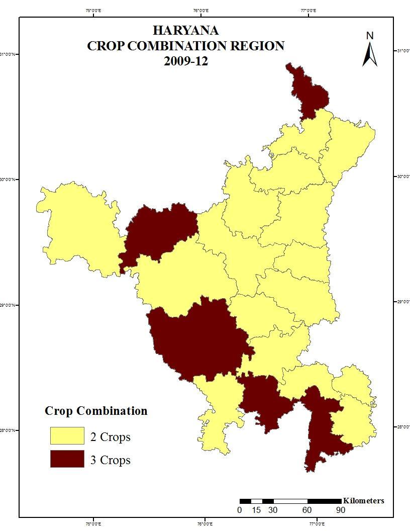
7 218 Crop Combination Pattern in Haryana ( ) NO. OF CROPS NAME OF DISTRICTS NO. OF DISTRICTS 2 CROP AMBALA,KURUKSHETRA,KAITHAL,KARNAL,PANIPAT,SONIPAT,MAHENDERGARH, 7 3 CROP ROHTAK,FARIDABAD,GURGAON,REWARI,BHIWANI,HISSAR,SIRSA 7 4 CROP YAMUNANAGAR,JIND 2
8 219 This map is show the Four crop combination region in yamunanagar and jind district. Two crop combination region in nortern Haryana and three crop combination region are Southern and Western Haryana. Nothern Haryana soil is fertile and irrigation facility is good so the two crop combination identified because farmers grows only two crop for his economic profit. Percentage of area under different crops in (ha.) ( ) NAME OF DISTRICTS RICE JOWA R BAJRA MAIZE WHEAT BARLE Y GRAM OTH. PULSE S MUSTAR D COTTON SUGARCAN E OTH. CROPS AMBALA PANCHKULA YAMUNANAGAR KURUKSHETRA KAITHAL KARNAL PANIPAT SONIPAT ROHTAK JHAJHAR FARIDABAD PALWAL GURGAON MEWAT REWARI MAHENDERGAR H BHIWANI JIND HISSAR FATEHABAD SIRSA HARYANA TOTAL
9 220 Crop Combination Regions of Haryana for Cropping Year ( ) SL DISTRICTS CROP CROPS N0. COMBINATION 1 AMBALA 2 WHEAT, RICE 2 PANCHKULA 3 WHEAT,RICE,MAIZE 3 YAMUNANAGAR 2 WHEAT,RICE 4 KURUKSHETRA 2 RICE,WHEAT 5 KAITHAL 2 WHEAT,RICE 6 KARNAL 2 WHEAT,RICE 7 PANIPAT 2 WHEAT,RICE 8 SONIPAT 2 WHEAT,RICE 9 ROHTAK 2 WHEAT,RICE 10 JHAJHAR 2 WHEAT,BAJRA 11 FARIDABAD 2 WHEAT,RICE 12 PALWAL 2 WHEAT,RICE 13 GURGAON 2 WHEAT,BAJRA 14 MEWAT 3 WHEAT,BAJRA,MUSTARD 15 REWARI 3 MUSTARD,BAJRA,WHEAT 16 MAHENDERGARH 2 BAJRA,MUSTARD 17 BHIWANI 3 BAJRA,WHEAT,MUSTARD 18 JIND 2 WHEAT,RICE 19 HISSAR 2 WHEAT,COTTON 20 FATEHABAD 3 WHEAT,COTTON,RICE 21 SIRSA 2 WHEAT,COTTON 22 HARYANA 3 WHEAT,RICE,BAJRA Crop Combination Pattern in Haryana ( ) NO. OF CROP S 2 CROP 3 CROP NAME OF DISTRICTS NO. OF DISTRICT S AMBALA, YAMUNANAGAR,KURUKSHETRA, KAITHAL, KARNAL, PANIPAT, 16 SONIPAT,ROHTAK,JHAJHAR,FARIDABAD,PALWAL,GURGAON,MAHENDERGARH,JIND,HISSAR,SI RSA PANCHKULA,, MEWAT, REWARI,BHIWANI, FATEHABAD 5
10 221
11 222 This map show only two and three crop combination region in Haryana. Because in present irrigation facility good and high yielding variety seeds available. And India technique better than past time so the farmers receiving good policy and farmer prefer to those crop who most expensive like Rice. First crop only (First Rank crop in Haryana) The First rank crop of northern Haryna wheat and southern Haryana rewari district first rank crop mustard and Mahendergarh and Bhiwani district first rank crop bajra and the Sirsa district first rank crop cotton in but Sirsa district first rank crop Wheat.
12 223 First two crop only The first two crop combination in Haryana mostly Wheat and Rice but Southern part of Haryana it is Mustard and Bajra and western part of Haryana Cotton and wheat crop are good combination. The gram crop in good combination with mustard and Bajra crop in Southern and Western Haryana but it replaced by Wheat crop. First Three crop only Three crop combination region find in this study area Western and Southern part of Haryana these three crop are Wheat-Mustard-Bajra and Wheat- Cotton- Gram and some part of middle Haryana find Wheat-mustard and jowar are good combination because Southern and Western part of Haryana dry area and sandy soil and low rainfall receive compare to East and North part of Haryana in But three crop replaced these areas to two crop combination. Fatehabad and Bhiwani Districts maintain three crop combination.

13 224 FIRST FOUR CROP ONLY The first four crop combination region in Haryana was seen in Yamunanagar and Jind District four crop combination region crops include are Wheat, Rice,Sugarcane,Maize,Cotton Bajra,Mustard are good combination. But not any districts show to four crop combination region.
14 225
15 226 Changes in crop combination in Haryana ( To ) SR. NO. DISTRICTS Change 1 AMBALA PANCHKULA NA YAMUNANAGAR KURUKSHETRA KAITHAL KARNAL PANIPAT SONIPAT ROHTAK JHAJHAR NA 2 NA 11 FARIDABAD PALWAL NA 2 NA 13 GURGAON MEWAT NA 3 NA 15 REWARI MAHENDERGARH BHIWANI JIND HISSAR FATEHABAD NA 3 NA 21 SIRSA HARYANA This table show the minor change overall Haryana. Yamunanagar and jind district change In crop combination region two districts was seen four crop combination but thse districts combination declined in CONCLUSION The crop combination region in Haryana area under wheat and rice is continuously increasing whereas the area under gram, sugarcane and barley has been continuously decreasing. Two crop combination region has observed in northern Haryana in both time period. Central and western Haryana continuously maintain their dominant position in term of cotton crop.gram cultivation has drastic declined in term of total cropped area from the base year ( ) in which it account 7.75% of the area under cultivation, now it has only 1.42% area under cultivation ( ). In Bhiwani district, the Gram and Bajra combination was seen in and in it was replaced by the combination of wheat and Bajra
16 227 REFERENCES Singh J. and Dhillon, S.S. (1984), Agriculture Geography, Tata McGraw Hill Publishing Company Limited, New Delhi. p Singh, J. (1976), An Agricultural Geography of Haryana, Vishal Publication, Kurukshetra, Singh, J. and Dhillon, S.S. (2004): "Agricultural Geography", Tata McGraw- Hill Publishing Company Limited, New Delhi, p Hussain,Mazid (2010): Agricultural Geography Rawat Publication, New Delhi, p Bhatia, (1965): "Patterns of Crop Concentration and Diversification in India", Economic Geography, 41, pp Tiwari, R.C. (2006) Agriculture Geography, Prayag Pustak Bhawan, Ellahabad. P Hussain, Mazid (1970). Crop Combination Regions of Uttar Pradesh : A Study in Methodology, Geographical Review of India.
NATURE AND EXTENT OF MICROFINANCE IN HARYANA
 CHAPTER - 3 NATURE AND EXTENT OF MICROFINANCE IN HARYANA In this chapter, nature, extent and progress of microfinance have been discussed related to our study area of Haryana. To analyze the status and
3. HYDROMETEROLOGY. 3.1 Introduction. 3.2 Hydro-meteorological Aspect. 3.3 Rain Gauge Stations
 3. HYDROMETEROLOGY 3.1 Introduction Hydrometeorology is a branch of meteorology and hydrology that studies the transfer of water and energy between the land surface and the lower atmosphere. Detailed hydrological
Figure 2.1: Constituent Area
 2 The Region 2.1 CONSTITUENT AREA The National Capital Region includes NCT-Delhi, nine districts of Haryana, six districts of Uttar Pradesh and one district of Rajasthan. Total area of the region is 34,144
Land Use and Land Cover Mapping and Change Detection in Jind District of Haryana Using Multi-Temporal Satellite Data
 Land Use and Land Cover Mapping and Change Detection in Jind District of Haryana Using Multi-Temporal Satellite Data Ravindra Prawasi, M.P. Sharma, T. P. Babu, Om Pal, Saroj, Kirti Yadav, R.S.Hooda Abstract
Wastelands Analysis and Mapping of Bhiwani District, Haryana
 Wastelands Analysis and Mapping of Bhiwani District, Haryana Virender Sihag Research Scholar, Department of Geography, OPJS University, Churu, Rajasthan ABSTRACT This study aimed at monitoring, mapping,
URBAN SPRAWL AND SPATIO TEMPORAL ANALYSIS OF HISAR CITY IN HARYANA USING REMOTE SENSING & GIS TECNOLOGY
 URBAN SPRAWL AND SPATIO TEMPORAL ANALYSIS OF HISAR CITY IN HARYANA USING REMOTE SENSING & GIS TECNOLOGY Shashikant 1, Pallavi Singh 2, R. D. Doi 3, Ankur Sharma 4, Ravinder Kumar 5, Parveen Bhatti 6 Abstract
DROUGHT RISK EVALUATION USING REMOTE SENSING AND GIS : A CASE STUDY IN LOP BURI PROVINCE
 DROUGHT RISK EVALUATION USING REMOTE SENSING AND GIS : A CASE STUDY IN LOP BURI PROVINCE K. Prathumchai, Kiyoshi Honda, Kaew Nualchawee Asian Centre for Research on Remote Sensing STAR Program, Asian Institute
Plantations Mapping of Dabwali, Rania and Ellenabad blocks of Sirsa District Using on Screen Visual Interpretation Approach on WV-2 Data
 s Mapping of Dabwali, Rania and Ellenabad blocks of Sirsa District Using on Screen Visual Interpretation Approach on WV-2 Data Savita 1, Veena 2, Reetu Sharma 3 Haryana Space Applications Centre (HARSAC),
Generation and analysis of Digital Elevation Model (DEM) using Worldview-2 stereo-pair images of Gurgaon district: A geospatial approach
 using Worldview-2 stereo-pair images of Gurgaon district: A geospatial approach") 186 Generation and analysis of Digital Elevation Model (DEM) using Worldview-2 stereo-pair images of Gurgaon district: A geospatial approach Arsad Khan 1, Sultan Singh 2 and Kaptan Singh 2 1 Department
186 Generation and analysis of Digital Elevation Model (DEM) using Worldview-2 stereo-pair images of Gurgaon district: A geospatial approach Arsad Khan 1, Sultan Singh 2 and Kaptan Singh 2 1 Department
Thematic Mapping in Siwani Area, District Bhiwani using Remote Sensing and Gis
 International Journal of Research in Geography (IJRG) Volume 3, Issue 2, 2017, PP 12-17 ISSN 2454-8685 (Online) DOI: http://dx.doi.org/10.20431/2454-8685.0302002 www.arcjournals.org Thematic Mapping in
THE STUBBLE BURNING IN THE STATES OF PUNJAB & HARYANA: A GIS BASED SPATIO-TEMPORAL ANALYSIS (from 2012 to 2017)
") Scholarly Research Journal for Interdisciplinary Studies, Online ISSN 2278-8808, SJIF 2018 = 6.371, www.srjis.com PEER REVIEWED JOURNAL, NOV-DEC, 2018, VOL- 6/48 THE STUBBLE BURNING IN THE STATES OF PUNJAB
Scholarly Research Journal for Interdisciplinary Studies, Online ISSN 2278-8808, SJIF 2018 = 6.371, www.srjis.com PEER REVIEWED JOURNAL, NOV-DEC, 2018, VOL- 6/48 THE STUBBLE BURNING IN THE STATES OF PUNJAB
International Journal of Scientific Research and Reviews
 Case Study Available online www.ijsrr.org ISSN: 2279 0543 International Journal of Scientific Research and Reviews Study on the Pattern of Land Use /Land Cover Change in Sonipat District of NCR, A Block
Effect of rainfall and temperature on rice yield in Puri district of Odisha in India
 2018; 7(4): 899-903 ISSN (E): 2277-7695 ISSN (P): 2349-8242 NAAS Rating: 5.03 TPI 2018; 7(4): 899-903 2018 TPI www.thepharmajournal.com Received: 05-02-2018 Accepted: 08-03-2018 A Baliarsingh A Nanda AKB
DATA BASE AND METHODOLOGY
 DATA BASE AND METHODOLOGY The work is mainly based on primary data which will be generated through field work. The interviews and discussions with member of management of sugar factories in the district
OUR COUNTRY INDIA LOCATIONAL SETTING
 7 India is a country of vast geographical expanse. In the north, it is bound by the lofty Himalayas. The Arabian Sea in the west, the Bay of Bengal in the east and the Indian Ocean in the south, wash the
MINISTRY OF ROAD TRANSPORT AND HIGHWAYS Through Punjab PWD B&R PROJECT REPORT
 MINISTRY OF ROAD TRANSPORT AND HIGHWAYS Through Punjab PWD B&R CONSULTANCY SERVICES FOR PREPARATION OF FEASIBILITY SURVEY, DETAILED PROJECT REPORT OF EXISTING TWO LANE PLUS SHOULDER TO (4LANING OF TALWANDI
SPACING OF RURAL SETTLEMENTS IN NAGAUR DISTRICT, RAJASTHAN: A SPATIAL ANALYSIS
 Journal of Global Resources Volume 5 July 2017 Page 28-33 ISSN: 2395-3160 (Print), 2455-2445 (Online) 05 SPACING OF RURAL SETTLEMENTS IN NAGAUR DISTRICT, RAJASTHAN: A SPATIAL ANALYSIS Varun Binda Assistant
S. NAJMUL ISLAM HASHMI
 Curriculum Vitae S. NAJMUL ISLAM HASHMI PROFESSOR Department of Geography Aligarh Muslim University Aligarh, 202002 Uttar Pradesh India e-mail: snihashmi@gmail.com Phone: (+91)9412276638 Academic Credentials
GIS Based Delineation of Micro-watershed and its Applications: Mahendergarh District, Haryana
 Kamla-Raj 2012 J Hum Ecol, 38(2): 155-164 (2012) GIS Based Delineation of Micro-watershed and its Applications: Mahendergarh District, Haryana Gulshan Mehra and Rajeshwari * Department of Geography, Kurukshetra
variation analysis of Vattamalaikarai sub basin, Tamil Nadu, India.
 A Study on the Rainfall Changes of Orathanadu Taluk Thanjavur District Tamil Nadu Using GIS P. Sujatha 1, Dr. R Baskaran 2 1 Research Scholar, Department of Industries and Earth Sciences, Tamil University,
CHAPTERN-III DENSITY AND DISTRIBUTION OF POPULATION
 CHAPTERN-III DENSITY AND DISTRIBUTION OF POPULATION 3.1 Introduction. 3.2 Determinants of population Distribution and Density. 3.3 Trends of Population Density. 3.4 Variation in Density of Population for
Estimation of Seismic Hazard Using PSHA in and around National Capital Region (NCR) of India
 of India") Geosciences 2017, 7(4): 109-116 DOI: 10.5923/j.geo.20170704.01 Estimation of Seismic Hazard Using PSHA in and around National Capital Region (NCR) of India S. Sarkar, D. Shanker * Department of Earthquake
Geosciences 2017, 7(4): 109-116 DOI: 10.5923/j.geo.20170704.01 Estimation of Seismic Hazard Using PSHA in and around National Capital Region (NCR) of India S. Sarkar, D. Shanker * Department of Earthquake
[Penumaka, 7(1): January-March 2017] ISSN Impact Factor
![[Penumaka, 7(1): January-March 2017] ISSN Impact Factor](/thumbs/95/124653515.jpg "[Penumaka, 7(1): January-March 2017] ISSN Impact Factor") INTERNATIONAL JOURNAL OF ENGINEERING SCIENCES &MANAGEMENT HYDROGEOMORPHOLOGY OF CHEVELLA BASIN, RANGA REDDY DISTRICT, TELANGANA STATE Penumaka Ramesh* 1 & Podila Sankara Pitchaiah 2 * 1&2 Department of
INTERNATIONAL JOURNAL OF ENGINEERING SCIENCES &MANAGEMENT HYDROGEOMORPHOLOGY OF CHEVELLA BASIN, RANGA REDDY DISTRICT, TELANGANA STATE Penumaka Ramesh* 1 & Podila Sankara Pitchaiah 2 * 1&2 Department of
Land use land cover thematic mapping using remote sensing & GIS Techniques: A case study of district Hisar
 2018; 4(7): 06-10 ISSN Print: 2394-7500 ISSN Online: 2394-5869 Impact Factor: 5.2 IJAR 2018; 4(7): 06-10 www.allresearchjournal.com Received: 02-05-2018 Accepted: 04-06-2018 Research Scholar, Department
W E E K L Y MONSOON INSIGHT
 W E E K L Y MONSOON INSIGHT 08 th July 2016 Indian Monsoon Dynamics Recent Weather Development India received 35% surplus rainfall in the week ended 6 July with all regions recording above-normal rainfall
DROUGHT ASSESSMENT USING SATELLITE DERIVED METEOROLOGICAL PARAMETERS AND NDVI IN POTOHAR REGION
 DROUGHT ASSESSMENT USING SATELLITE DERIVED METEOROLOGICAL PARAMETERS AND NDVI IN POTOHAR REGION Researcher: Saad-ul-Haque Supervisor: Dr. Badar Ghauri Department of RS & GISc Institute of Space Technology
SPATIO-TEMPORAL ANALYSIS OF URBAN POPULATION GROWTH AND DISTRIBUTION IN AURANGABAD CITY
 International Journal of Research in Social Sciences Vol. 8 Issue 3, March 2018, ISSN: 2249-2496 Impact Factor: 7.081 Journal Homepage: Double-Blind Peer Reviewed Refereed Open Access International Journal
SRJIS/BIMONTHLY/S. A. BORUDE. ( ) APPLICATION OF SPATIAL VARIATION URBAN DENSITY MODEL: A STUDY OF AHMEDNAGAR CITY, MAHARASHTRA, INDIA
 APPLICATION OF SPATIAL VARIATION URBAN DENSITY MODEL: A STUDY OF AHMEDNAGAR CITY, MAHARASHTRA, INDIA") APPLICATION OF SPATIAL VARIATION URBAN DENSITY MODEL: A STUDY OF AHMEDNAGAR CITY, MAHARASHTRA, INDIA S.A. Borude, Assistant Professor, PG, Dept. of Geography, Ahmednagar College, Ahmednagar, Maharashtra.
APPLICATION OF SPATIAL VARIATION URBAN DENSITY MODEL: A STUDY OF AHMEDNAGAR CITY, MAHARASHTRA, INDIA S.A. Borude, Assistant Professor, PG, Dept. of Geography, Ahmednagar College, Ahmednagar, Maharashtra.
Effect of land use/land cover changes on runoff in a river basin: a case study
 Water Resources Management VI 139 Effect of land use/land cover changes on runoff in a river basin: a case study J. Letha, B. Thulasidharan Nair & B. Amruth Chand College of Engineering, Trivandrum, Kerala,
THE ROLE OF GEOSPATIAL TECHNOLOGY IN SOCIAL AMENITIES FOR RURAL DEVELOPMENT
 THE ROLE OF GEOSPATIAL TECHNOLOGY IN SOCIAL AMENITIES FOR RURAL DEVELOPMENT ANAND P. PANDIT, P.G. Department of Geography, New Arts Commerce and Science College, Ahmednagar. (MS) INDIA MADHUKAR R. KARALE
Geospatial Mapping of Fisheries Profile of Chhattisgarh state through GIS
 Geospatial Mapping of Fisheries Profile of Chhattisgarh state through GIS Ram Singh*, P.K. Pandey, M. Krishnan and Shyam Salim Central Institute of Fisheries Education (Deemed University), Mumbai-400 061
Guru Jambheshwar University of Science & Technology, Hisar
 Guru Jambheshwar University of Science & Technology, Hisar Scheme for Theory + Practical Based Subjects Guidelines for Scheme of examination of UG Course GEOGRAPHY-B.A. Pass course (under semester system)
VILLAGE INFORMATION SYSTEM (V.I.S) FOR WATERSHED MANAGEMENT IN THE NORTH AHMADNAGAR DISTRICT, MAHARASHTRA
 FOR WATERSHED MANAGEMENT IN THE NORTH AHMADNAGAR DISTRICT, MAHARASHTRA") VILLAGE INFORMATION SYSTEM (V.I.S) FOR WATERSHED MANAGEMENT IN THE NORTH AHMADNAGAR DISTRICT, MAHARASHTRA Abstract: The drought prone zone in the Western Maharashtra is not in position to achieve the agricultural
VILLAGE INFORMATION SYSTEM (V.I.S) FOR WATERSHED MANAGEMENT IN THE NORTH AHMADNAGAR DISTRICT, MAHARASHTRA Abstract: The drought prone zone in the Western Maharashtra is not in position to achieve the agricultural
BANK OF SANCTION FOR ROB & BRIDGES (UPDATED ON ).
.") BANK OF SANCTION FOR ROB & BRIDGES (UPDATED ON 21.05.2014). Budget allotment under head 5054 R&B plan for construction of ROB & Bridges for the year 2014-15 is Rs. 65.00 Crore which is further reduce to
BANK OF SANCTION FOR ROB & BRIDGES (UPDATED ON 21.05.2014). Budget allotment under head 5054 R&B plan for construction of ROB & Bridges for the year 2014-15 is Rs. 65.00 Crore which is further reduce to
1 LAND USE PLANNING IN INDIA - RETROSPECT AND PROSPECT
 1 LAND USE PLANNING IN INDIA - RETROSPECT AND PROSPECT T. Haque National Fellow, National Centre for Agricultural Economics and Policy Research, New Delhi Ever since independence, India's planners and
Development of regression models in ber genotypes under the agroclimatic conditions of south-western region of Punjab, India
 Indian J. Agric. Res., 49 (3) 2015: 260-264 Print ISSN:0367-8245 / Online ISSN:0976-058X AGRICULTURAL RESEARCH COMMUNICATION CENTRE www.arccjournals.com/www.ijarjournal.com Development of regression models
Probability models for weekly rainfall at Thrissur
 Journal of Tropical Agriculture 53 (1) : 56-6, 015 56 Probability models for weekly rainfall at Thrissur C. Laly John * and B. Ajithkumar *Department of Agricultural Statistics, College of Horticulture,
DELINEATION OF NATIONAL CAPITAL REGION
 AIM To analyze the given article and understand the concept of regional delineation and its relation with planning techniques. GAURAB DAS MAHAPATRA 2015MURP010 DELINEATION OF NATIONAL CAPITAL REGION MPLN0107
Use of SAR data for Rice Assessment
 Use of SAR data for Rice Assessment N e e t u, S h i b e n d u S R a y a n d T e a m M a h a l a n o b i s N a t i o n a l C r o p F o r e c a s t C e n t r e, D e p a r t m e n t o f A g r i c u l t u
Development of the Regression Model to Predict Pigeon Pea Yield Using Meteorological Variables for Marathwada Region (Maharashtra)
") Available online at www.ijpab.com Singh et al Int. J. Pure App. Biosci. 5 (6): 1627-1631 (2017) ISSN: 2320 7051 DOI: http://dx.doi.org/10.18782/2320-7051.5445 ISSN: 2320 7051 Int. J. Pure App. Biosci.
Available online at www.ijpab.com Singh et al Int. J. Pure App. Biosci. 5 (6): 1627-1631 (2017) ISSN: 2320 7051 DOI: http://dx.doi.org/10.18782/2320-7051.5445 ISSN: 2320 7051 Int. J. Pure App. Biosci.
Seasonal Rainfall Trend Analysis
 RESEARCH ARTICLE OPEN ACCESS Seasonal Rainfall Trend Analysis Devdatta V. Pandit Research Scholar, Dept. of SWCE, M.P.K.V, Rahuri- 413722, Ahmednagar. (M., India ABSTRACT This study aims to detect the
Land Cover Atlas of Pakistan The Punjab Province
 Land Cover By District Land Cover Atlas of Pakistan The Punjab Province Rahim Yar Khan Rahim Yar Khan district is known for its main crops like cotton, sugarcane and wheat. Most of the orchards are of
Intraseasonal Characteristics of Rainfall for Eastern Africa Community (EAC) Hotspots: Onset and Cessation dates. In support of;
 Hotspots: Onset and Cessation dates. In support of;") Intraseasonal Characteristics of Rainfall for Eastern Africa Community (EAC) Hotspots: Onset and Cessation dates In support of; Planning for Resilience in East Africa through Policy, Adaptation, Research
Intraseasonal Characteristics of Rainfall for Eastern Africa Community (EAC) Hotspots: Onset and Cessation dates In support of; Planning for Resilience in East Africa through Policy, Adaptation, Research
The trends and patterns of urbanization in the NCT of Delhi during
 International Journal of Interdisciplinary and Multidisciplinary Studies (IJIMS), 2015, Vol 2, No.4, 27-39. 27 Available online at http://www.ijims.com ISSN: 2348 0343 The trends and patterns of urbanization
The spatial distribution of rainfall, extreme indices in Haryana (INDIA) using geographic information system
 using geographic information system") 2018; 7(2): 3624-3629 E-ISSN: 2278-4136 P-ISSN: 2349-8234 JPP 2018; 7(2): 3624-3629 Received: 22-01-2018 Accepted: 23-02-2018 Mamta Diwan Singh Anurag Poonam Dept of Mathematics, Statistics & Physics,
2018; 7(2): 3624-3629 E-ISSN: 2278-4136 P-ISSN: 2349-8234 JPP 2018; 7(2): 3624-3629 Received: 22-01-2018 Accepted: 23-02-2018 Mamta Diwan Singh Anurag Poonam Dept of Mathematics, Statistics & Physics,
Board Question Paper : March 2015
 Board Question Paper : March 2015 BOARD QUESTION PAPER : MARCH 2015 Time: 2 Hours Total Marks: 40 Note: i. All questions are compulsory. ii. Figure to the right indicate full marks. iii. Solve Q. No.3
JRC MARS Bulletin global outlook 2017 Crop monitoring European neighbourhood Turkey June 2017
 MARS Bulletin global outlook 2015-06 r JRC MARS Bulletin global outlook 2017 Crop monitoring European neighbourhood Turkey June 2017 Favourable spring conditions, but slight delay Yield forecasts for winter
Chapter 27. Bhutan, Maldives, Nepal, & Sri Lanka
 Chapter 27 Bhutan, Maldives, Nepal, & Sri Lanka Physical Geography of Bhutan, Maldives, Nepal & Sri Lanka Landforms Their locations on the fringe of South Asia means their physical and human geography
Chapter-3 GEOGRAPHICAL LOCATION, CLIMATE AND SOIL CHARACTERISTICS OF THE STUDY SITE
 Chapter-3 GEOGRAPHICAL LOCATION, CLIMATE AND SOIL CHARACTERISTICS OF THE STUDY SITE Chapter-3 GEOGRAPHICAL LOCATION, CLIMATE AND SOIL CHARACTERISTICS OF THE STUDY SITE Assam, the eastern most state of
Suppressed Surface Heating over northwestern parts of the Country and the ensuing Monsoon Rainfall
 Suppressed Surface Heating over northwestern parts of the Country and the ensuing Monsoon Rainfall During this year, the temperatures have been below normal over north and northwestern parts of India.
GEOGRAPHY QUESTION PAPER CODE 64/1/1. 4. Distinguish between towns and villages on the basis of occupation. 1
 GEOGRAPHY Time allowed : 3 hours Maximum Marks : 70 GENERAL INSTRUCTIONS : (i) (ii) There are 22 geneal questions. Question numbers 1-7 are very short answer questions carrying 1 mark each. Answer to these
Comparative Study of Quantitative and Cartographic Techniques of Banana Crop Concentration in Raver Tehsil of Jalgaon District (M.S.
 Journal of Geography and Geology; Vol. 4, No. 2; 2012 ISSN 1916-9779 E-ISSN 1916-9787 Published by Canadian Center of Science and Education Comparative Study of Quantitative and Cartographic Techniques
GEOGRAPHY (OPT.) MAINS 2017 (PAPER- II) Vs GUIDANCE IAS 500+ QUESTIONS July 2017 GEOGRAPHY (OPT.) MAINS 2017 (PAPER- II)
 MAINS 2017 (PAPER- II) Vs GUIDANCE IAS 500+ QUESTIONS July 2017 GEOGRAPHY (OPT.) MAINS 2017 (PAPER- II)") GEOGRAPHY (OPT.) MAINS 2017 (PAPER- II) Vs GUIDANCE IAS 500+ QUESTIONS July 2017 GEOGRAPHY (OPT.) MAINS 2017 (PAPER- II) Q1(b) Give a reasoned account of unusual pattern of distribution of monsoonal rainfall
GEOGRAPHY (OPT.) MAINS 2017 (PAPER- II) Vs GUIDANCE IAS 500+ QUESTIONS July 2017 GEOGRAPHY (OPT.) MAINS 2017 (PAPER- II) Q1(b) Give a reasoned account of unusual pattern of distribution of monsoonal rainfall
Flood hazard mapping in Urban Council limit, Vavuniya District, Sri Lanka- A GIS approach
 International Research Journal of Environment Sciences E-ISSN 2319 1414 Flood hazard mapping in Urban Council limit, Vavuniya District, Sri Lanka- A GIS approach Abstract M.S.R. Akther* and G. Tharani
Date of. Issued by (AICRPAM), & Earth System
, & Earth System") National Agromet Advisory Service Bulletin Based on Extended Range Weather Forecast (ERFS) Validity: 29 September 12 October 2017 Date of Issue: 29 September 2017 Issued by Indian Council of Agricultural
National Agromet Advisory Service Bulletin Based on Extended Range Weather Forecast (ERFS) Validity: 29 September 12 October 2017 Date of Issue: 29 September 2017 Issued by Indian Council of Agricultural
Rainfall variation and frequency analysis study of Salem district Tamil Nadu
 Indian Journal of Geo Marine Sciences Vol. 46 (1), January 217, pp. 213-218 Rainfall variation and frequency analysis study of Salem district Tamil Nadu Arulmozhi.S 1* & Dr. Prince Arulraj.G 2 1 Department
Chapter 27. Bhutan, Maldives, Nepal, & Sri Lanka
 Chapter 27 Bhutan, Maldives, Nepal, & Sri Lanka Physical Geography of Bhutan, Maldives, Nepal & Sri Lanka Landforms Their locations on the fringe of South Asia means their physical and human geography
UNIT 11 INTER STATE AND INTER DISTRICT IMBALANCES
 UNIT 11 INTER STATE AND INTER DISTRICT IMBALANCES Inter State and Inter District Imbalances Structure 11.0 Objectives 11.1 Introduction 11.2 Conceptual Bases to Understand the Issues of Regional Imbalances
Spatial and Temporal Analysis of Rainfall Variation in Yadalavagu Hydrogeological unit using GIS, Prakasam District, Andhra Pradesh, India
 International Research Journal of Environment Sciences ISSN 2319 1414 Spatial and Temporal Analysis of Rainfall Variation in Yadalavagu Hydrogeological unit using GIS, Prakasam District, Andhra Pradesh,
EVALUATION OF SOME MANGO CULTIVARS UNDER NORTH INDIAN CONDITIONS
 Proceedings: International Conference on Mango and Date Palm: Culture and Export. 20 th to 23 rd June, 2005. Malik et al. (Eds), University of Agriculture, Faisalabad. EVALUATION OF SOME MANGO CULTIVARS
INTERNATIONAL JOURNAL OF GEOMATICS AND GEOSCIENCES Volume 7, No 2, 2016
 INTERNATIONAL JOURNAL OF GEOMATICS AND GEOSCIENCES Volume 7, No 2, 2016 Copyright by the authors - Licensee IPA- Under Creative Commons license 3.0 Research article ISSN 0976 4380 Development of micro
Explain the impact of location, climate, natural resources, and population distribution on Europe. a. Compare how the location, climate, and natural
 SS6G10 Explain the impact of location, climate, natural resources, and population distribution on Europe. a. Compare how the location, climate, and natural resources of Germany, the United Kingdom and
SEASONAL RAINFALL FORECAST FOR ZIMBABWE. 28 August 2017 THE ZIMBABWE NATIONAL CLIMATE OUTLOOK FORUM
 2017-18 SEASONAL RAINFALL FORECAST FOR ZIMBABWE METEOROLOGICAL SERVICES DEPARTMENT 28 August 2017 THE ZIMBABWE NATIONAL CLIMATE OUTLOOK FORUM Introduction The Meteorological Services Department of Zimbabwe
GEOGRAPHY. Parts/Units Topics Marks. Part A Fundamentals of Human Geography 35. Map Work 5. Part B India: People and Economy 35
 GEOGRAPHY Course Structure Parts/Units Topics Marks Part A Fundamentals of Human Geography 35 Unit 1 Unit 2 Unit 3 Unit 4 Unit 5 Human Geography People Human Activities Transport, Communication & Trade
Temporal and Spatial Analysis of Drought over a Tropical Wet Station of India in the Recent Decades Using the SPI Method
 Temporal and Spatial Analysis of Drought over a Tropical Wet Station of India in the Recent Decades Using the SPI Method Keerthi Sasikumar 1 and Dr. Venu G.Nair 2 1 Department of Atmospheric Sciences,
APPENDIX TABLE 1 Expansion of the National Malaria Control Program Population protected. # Units established (cumulative)
") Appendix A.1. The National Malaria Control Program APPENDIX TABLE 1 Expansion of the National Malaria Control Program Population protected # Units established # Units established (cumulative) (cumulative,
Appendix A.1. The National Malaria Control Program APPENDIX TABLE 1 Expansion of the National Malaria Control Program Population protected # Units established # Units established (cumulative) (cumulative,
Sec$on 1: Geography and Early China. How does China s geography affect the culture?
 Sec$on 1: Geography and Early China How does China s geography affect the culture? Con$nents of the World Label the continents. Where is China located? Where is China located? In your groups, begin filling
Simulating urban growth in South Asia: A SLEUTH application
 Simulating urban growth in South Asia: A SLEUTH application Gargi Chaudhuri* 1 1 1725 State St., 2022 Cowley Hall, Department of Geography and Earth Science, University of Wisconsin-La Crosse *Email: gchaudhuri@uwlax.edu
Summary and Conclusions
 241 Chapter 10 Summary and Conclusions Kerala is situated in the southern tip of India between 8 15 N and 12 50 N latitude and 74 50 E and 77 30 E longitude. It is popularly known as Gods own country.
Land Use / Land Cover Change of Delhi: A Study using Remote Sensing and GIS Techniques
 International Research Journal of Earth Sciences ISSN 2321 2527 Int. Res.J. Earth Sci. Land Use / Land Cover Change of Delhi: A Study using Remote Sensing and GIS Techniques Abstract Singh Bijender 1 and
Feature Extraction using Normalized Difference Vegetation Index (NDVI): a Case Study of Panipat District
: a Case Study of Panipat District") Feature Extraction using Normalized Difference Vegetation Index (NDVI): a Case Study of Panipat District Seema Rani, Rajeev 2, Ravindra Prawasi 3 Haryana Space Applications Centre, CCS HAU Campus, Hisar
Feature Extraction using Normalized Difference Vegetation Index (NDVI): a Case Study of Panipat District Seema Rani, Rajeev 2, Ravindra Prawasi 3 Haryana Space Applications Centre, CCS HAU Campus, Hisar
Module 3, Investigation 1: Briefing 2 The ENSO game: Predicting and managing for El Niño and La Niña
 Part 5. The ENSO game How can prediction help avoid ENSO s tragic human consequences? Scientists from around the world are involved in forecasting, with computer models and sophisticated measurements,
HIGH RESOLUTION SATELLITE DATA FOR LAND USE/LAND COVER MAPPING IN ROHTAK DISTRICT HARYANA, INDIA
 HIGH RESOLUTION SATELLITE DATA FOR LAND USE/LAND COVER MAPPING IN ROHTAK DISTRICT HARYANA, INDIA MR. MUKESH KUMAR 1 AND MR.SANDEEP KUMAR 2 1. M.tech. Student, Department of Geography, M.D.University Rohtak,
Droughts are normal recurring climatic phenomena that vary in space, time, and intensity. They may affect people and agriculture at local scales for
 I. INTRODUCTION 1.1. Background Droughts are normal recurring climatic phenomena that vary in space, time, and intensity. They may affect people and agriculture at local scales for short periods or cover
Settlements are the visible imprint made by the man upon the physical
 Settlements are the visible imprint made by the man upon the physical landscape through the process of cultural occupancy. It is manmade colony of human being in which they live, work, and move to pursue
Forecasting Area, Production and Yield of Cotton in India using ARIMA Model
 Forecasting Area, Production and Yield of Cotton in India using ARIMA Model M. K. Debnath 1, Kartic Bera 2 *, P. Mishra 1 1 Department of Agricultural Statistics, Bidhan Chanda Krishi Vishwavidyalaya,
Global South / Global North: Africa, Asia & Latin America versus US Midwest: Retracing 1500 to the present as Environmental History
 Global South / Global North: Africa, Asia & Latin America versus US Midwest: Retracing 1500 to the present as Environmental History The habitual weakness of the American people is to assume that they have
Morphometric Analysis of Chamundi Hills, Mysuru, India Using Geographical Information System
 Volume-7, Issue-1, January-February 2017 International Journal of Engineering and Management Research Page Number: 279-283 Morphometric Analysis of s, Mysuru, India Using Geographical Information System
ABSTRACT. 2. Location : 31 o 04'16'' to 32 o 31'27'' North Latitudes and 74 o 30'38'' to 76 o 08'45'' East Longitudes
 ABSTRACT 1. Surveyed Area : Prioritization of Microwatersheds of Beas Catchment (1B1) of Districts-Amritsar, Firozpur, Gurdaspur, Hoshiarpur, Jalandhar, Kapurthala, Tarntaran, Punjab State and Districts-
September 2016 No. ICPAC/02/293 Bulletin Issue October 2016 Issue Number: ICPAC/02/294 IGAD Climate Prediction and Applications Centre Monthly Bulleti
 Bulletin Issue October 2016 Issue Number: ICPAC/02/294 IGAD Climate Prediction and Applications Centre Monthly Bulletin, For referencing within this bulletin, the Greater Horn of Africa (GHA) is generally
Nageshwar Prasad, Burdwan and Tanusree Ghosh, Birbhum, West Bengal
 Trans. Inst. Indian Geographers Nageshwar Prasad, Burdwan and Tanusree Ghosh, Birbhum, West Bengal Land capability simply implies the measurement of capability of land for particular land uses. Land capability
INTERNATIONAL JOURNAL OF GEOMATICS AND GEOSCIENCES Volume 6, No 2, 2015
 INTERNATIONAL JOURNAL OF GEOMATICS AND GEOSCIENCES Volume 6, No 2, 2015 Copyright by the authors - Licensee IPA- Under Creative Commons license 3.0 Research article ISSN 0976 4380 An Analysis of Land use
Weather Outlook. 1 July 2016 METEOROLOGICAL RESEARCH GROUP. INDIA HEADQUART ERS G 31 Quest Offices DLF Golf Course Road Gurgaon India
 Weather Outlook 1 July 2016 METEOROLOGICAL RESEARCH GROUP INDIA HEADQUART ERS G 31 Quest Offices DLF Golf Course Road Gurgaon 122 002 India NORTH AMERICA 350 Fifth Avenue 59 th Floor, New York City NY
CURRENT STATUS OF MONSOON Main Meteorological conditions of the last week (27August to 2 September)
") CURRENT STATUS OF MONSOON 2009 Main Meteorological conditions of the last week (27August to 2 September) Last week s low pressure area over Orissa and neighbourhood moved west-northwestwards across central
CURRENT STATUS OF MONSOON 2009 Main Meteorological conditions of the last week (27August to 2 September) Last week s low pressure area over Orissa and neighbourhood moved west-northwestwards across central
Economic Growth and Human Development: An Empirical Analysis of Major States of India During the Period to
 Economic Affairs: 59(1): 11-21 March, 2014 DOI Number 10.5958/J.0976-4666.59.1.002 Economic Growth and Human Development: An Empirical Analysis of Major States of India During the Period 1993-94 to 2004-05
LOCATION, SPACE AND TIME IN GEOGRAPHY
 LOCATION, SPACE AND TIME IN GEOGRAPHY Component-I(A) - Personal Details Chand Sultana Role Name Affiliation Principal Investigator Prof. Masood Ahsan Siddiqui Department of Geography, Jamia Millia Islamia,
Frequency analysis of rainfall deviation in Dharmapuri district in Tamil Nadu
 Indian Journal of Geo Marine Sciences Vol.46 (8), August 217, pp. 171-1714 Frequency analysis of rainfall deviation in Dharmapuri district in Tamil Nadu V. Rajendran 1* & R. Venkatasubramani 2 1 Department
PAKISTAN STUDIES 2059/02 The Environment of Pakistan
 PAKISTAN STUDIES 2059/02 The Environment of Pakistan The City School PAF Chapter Prep + Senior 1 Section Name: Section: Date: Time: 1 hour 30 minute Candidates answer on the Question Paper. READ THESE
ABSTRACT One of the serious problems that India facing today is the problem of regional disparities. It results in social, economic and political
 ABSTRACT One of the serious problems that India facing today is the problem of regional disparities. It results in social, economic and political instability. The current tension and strain in the Indian
Fog Hazards in Punjab
 Pakistan Journal of Meteorology Vol. 8, Issue 16: Jan, 2012 Fog Hazards in Punjab Aslam, M. 1 Abstract Using 30-year (1976-2005) real meteorological data of 10-weather stations, four dense fog years (1998-1999,
CHANGE DETECTION USING REMOTE SENSING- LAND COVER CHANGE ANALYSIS OF THE TEBA CATCHMENT IN SPAIN (A CASE STUDY)
") CHANGE DETECTION USING REMOTE SENSING- LAND COVER CHANGE ANALYSIS OF THE TEBA CATCHMENT IN SPAIN (A CASE STUDY) Sharda Singh, Professor & Programme Director CENTRE FOR GEO-INFORMATICS RESEARCH AND TRAINING
CHANGE DETECTION USING REMOTE SENSING- LAND COVER CHANGE ANALYSIS OF THE TEBA CATCHMENT IN SPAIN (A CASE STUDY) Sharda Singh, Professor & Programme Director CENTRE FOR GEO-INFORMATICS RESEARCH AND TRAINING
NETWORK ANALYSIS FOR URBAN EMERGENCY SERVICES IN SOLAPUR CITY, INDIA: A GEOINFORMATIC APPROACH
 NETWORK ANALYSIS FOR URBAN EMERGENCY SERVICES IN SOLAPUR CITY, INDIA: A GEOINFORMATIC APPROACH Sagar P. Mali * & Yogesh A. Mane ** * Research Student, Department of Geography, Shivaji University, Kolhapur,
ITL PUBLIC SCHOOL SECTOR 9, DWARKA SESSION SUMMATIVE ASSESSMENT (II) ANSWER KEY
 ANSWER KEY") ITL PUBLIC SCHOOL SECTOR 9, DWARKA SESSION 2014-2015 SUMMATIVE ASSESSMENT (II) ANSWER KEY DATE: 16.02.15 CLASS: I V SUBJECT: Social Studies TIME: 2 hrs. QI Multiple Choice Questions (choose the correct
ITL PUBLIC SCHOOL SECTOR 9, DWARKA SESSION 2014-2015 SUMMATIVE ASSESSMENT (II) ANSWER KEY DATE: 16.02.15 CLASS: I V SUBJECT: Social Studies TIME: 2 hrs. QI Multiple Choice Questions (choose the correct
Temperature ( C) Map 1. Annual Average Temperatures Are Projected to Increase Dramatically by 2050
 Map 1. Annual Average Temperatures Are Projected to Increase Dramatically by 2050") CO UNT RY S NA P SHO T India s Hotspots The Impact of Temperature and Precipitation Changes on Living Standards Climate change is already a pressing issue for India. Temperatures have risen considerably
CO UNT RY S NA P SHO T India s Hotspots The Impact of Temperature and Precipitation Changes on Living Standards Climate change is already a pressing issue for India. Temperatures have risen considerably
Post Independence Trends of Urbanization and Role of Small and Medium Towns in Maharashtra- A Geographical Analysis
 Post Independence Trends of Urbanization and Role of Small and Medium Towns in Maharashtra- A Geographical Analysis A careful and systematic study of the process of urbanization and related factors is
Raktim Haldar Research Scholar Department of Civil Engineering Indian Institute of Technology, Delhi
 Raktim Haldar Research Scholar Department of Civil Engineering Indian Institute of Technology, Delhi Issues to be addressed Introduction to the Vembanad Lake and surrounding scenario of development Anthropogenic
Rainfall is the major source of water for
 RESEARCH PAPER: Assessment of occurrence and frequency of drought using rainfall data in Coimbatore, India M. MANIKANDAN AND D.TAMILMANI Asian Journal of Environmental Science December, 2011 Vol. 6 Issue
ALL INDIA WEATHER SUMMARY AND FORECAST BULLETIN
 Sunday 22 April 2018 NIGHT Time of Issue: 2000 hours IST ALL INDIA WEATHER SUMMARY AND FORECAST BULLETIN Significant Weather Features The ongoing fairly widespread rainfall activity with isolated thunder
Abstract. TECHNOFAME- A Journal of Multidisciplinary Advance Research. Vol.2 No. 2, (2013) Received: Feb.2013; Accepted Oct.
 Received: Feb.2013; Accepted Oct.") Vol.2 No. 2, 83-87 (2013) Received: Feb.2013; Accepted Oct. 2013 Landuse Pattern Analysis Using Remote Sensing: A Case Study of Morar Block, of Gwalior District, M.P. Subhash Thakur 1 Akhilesh Singh 2
Vol.2 No. 2, 83-87 (2013) Received: Feb.2013; Accepted Oct. 2013 Landuse Pattern Analysis Using Remote Sensing: A Case Study of Morar Block, of Gwalior District, M.P. Subhash Thakur 1 Akhilesh Singh 2
Agro-climatic zonation for dry farming wheat in Zanjan Province, Iran
 RESEARCH PAPER OPEN ACCESS Agro-climatic zonation for dry farming wheat in Zanjan Province, Iran International Journal of Agronomy and Agricultural Research (IJAAR) ISSN: 2223-7054 (Print) 2225-3610 (Online)