Year 11 Geography. Paper 2 UK Geographical Issues. Mock Exam Revision Booklet
|
|
|
- Amberlynn Montgomery
- 5 years ago
- Views:
Transcription


1 Year 11 Geography Paper 2 UK Geographical Issues Mock Exam Revision Booklet
2 Contents Page Topic Exam Command Words How to structure your answers UK s Physical Landscape Checklist UK s Physical Landscape Key Words UK s Physical Landscape Revision Material UK s Physical Landscape Practice Questions Coasts Learning Checklist Coasts Key Words Coasts Revision Material Coasts Practice Questions UK s Human Landscape Checklist UK s Human Landscape Key Words UK s Human Landscape Revision Material UK s Human Landscape Practice Questions Geographical Investigations (Fieldwork) Checklist Geographical Investigations (Fieldwork) Key Words Geographical Investigations (Fieldwork) Revision Material Geographical Investigations (Fieldwork) Practice Questions Page Number
3 Command Word Identify/ Name/ State Exam Command Words Marks Meaning Example Question Sentence Starters/ Hints 1 Find/give a simple statement Identify the landform in the photo Define 1 Give the meaning Define the term fertility rate Calculate 1 or 2 Work out Calculate the mean age of a group of people Label 1 or 2 Print the name of/ Write on a map or diagram Draw 2 or 3 Sketch/ Draw a line Compare 3 Find the similarities and differences Label 2 features of the river in Figure 2 Draw a line to complete the graph in Figure 3 Compare the rate of population growth in 2 cities I can see. An example is This means. The term? means. Show your working out Use correct Geographical terminology Always draw in pencil This figure shows As you can see One similarity/ one difference that is evident Describe 2 or 3 What is it like/ Trends on graphs Describe the trends shown in Figure 1. Describe the increase in population Use PQE: Pattern Quantity Exceptions Use GCSE General Comment Specific Example or Exceptions Explain 2, 3 or 4 Give reasons why it happens Explain the formation of a meander PEE paragraphs This is because.. Suggest 2,3 or 4 Give a wellreasoned guess to explain Suggest reasons why flooding has become more frequent along this river One possible reason It may be that In some cases we might Assess 8 Weigh up which is most/least important Evaluate 8 Give a judgement: which is most/ least effective Select & Justify 12 Select and then give evidence to support Assess the need for coastal management along a stretch of coastline you studied Evaluate the methods used in collecting data in your fieldwork Select and justify the best option for the future of On one hand Some may suggest that The most important reason could be Evidence suggests Although In certain situations Contributed to Overall The reason for this Significant impacts However To conclude Some may suggest
4 How to structure your answers 1 mark Identify, State, Name, Define, Calculate, Label Write a simple sentence or just a few words 2 marks Calculate You must show your workings out Label Label/annotate at least 2 main things Draw Draw a diagram and label/annotate at least 2 main parts Describe state 2 things Explain Point, Explain Suggest Point, Development 3 marks Draw Draw a diagram and label/annotate at least 3 main parts Compare At least one difference and one similarity plus another of your choice Describe state 3 things Explain & Suggest Point & 2 development or Point, Development, Point 4 marks Explain & Suggest Point & Development x 2 8 marks 4 marks for explanation & 4 marks for use of evidence Assess Explanation Requires you to explain which you think is the most important aspect of something in relation to others. Give 4 reasons for your decision or opinion Use of evidence May require you to find evidence in a figure and/or use your own knowledge to give evidence for your decisions. Learn case studies and named examples. Evaluate E.g. Global responses to climate change are more important than local response because. Require you to explain how successful you think something is or has been. Give 4 reasons for your decision. E.g. India has been successful in managing the environmental impacts of slims in Mumbai because Require you to use your own knowledge of the world to answer the question and provide evidence. Learn case studies and named examples.
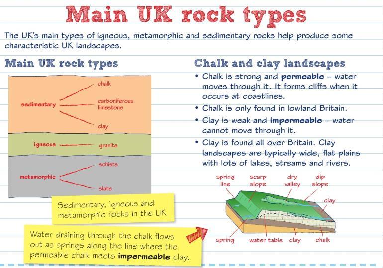
5 UK s Physical Landscape Checklist Learning Objective I understand the role of geology, past tectonics and glacial processes in the development of upland and lowland areas. I understand the characteristics and distribution of the UK s main rock types: sedimentary, igneous, and metamorphic. I understand why distinctive upland and lowland landscaped result from interaction of physical processes: weathering and climatological, post-glacial river and slope processes. I understand why distinctive landscape result from human activity over time. (Agriculture forestry, settlement) UK s Physical Landscape Key Words Keyword Erosion Faults Glaciated Gradient Igneous Interlocking spurs Limestone Lowland landscape Definition wearing away the landscape large cracks caused by past tectonic movements formed or once covered by glaciers or ice sheets Slope Rock type formed from lavas and deep magmas. They were once molten, then cooled and crystallised hills that stick out on alternate sides of a V-shaped valley, like the teeth of a zip a pale grey rock consisting of crushed shells of corals that lived in tropical seas 300 million years ago an area of flat land that is at, near or below sea level, which in the UK usually consists of younger and less resistant sedimentary rocks
6 Mass movement Metamorphic Prevailing wind Sedimentary Strata Sub-aerial processes Upland landscape Uplifted U-shape Weathering the movement of material downslope, such as rock falls, landslides or cliff collapse sedimentary rocks that were heated and compressed during igneous activity the most frequent direction the wind blows in a certain area rock formed from sediments eroded and deposited by rivers, the sea, or on the sea bed distinctive layers of rock occurring on land, at the Earth s surface, as opposed to underwater or underground an area of high land, in the UK consisting of resistant igneous, metamorphic and sedimentary rock (in geology) raised or pushed up as a result of tectonic activity (river valley) deep valleys created by glaciers, shaped like the letter U with steep, straight sides and a flat bottom the physical, chemical or biological breakdown of solid rock by the action of weather (e.g. frost, rain) or plants


7 UK s Physical Landscape Revision Material
8
9
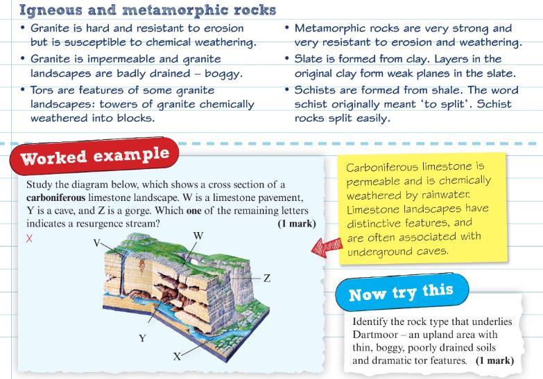
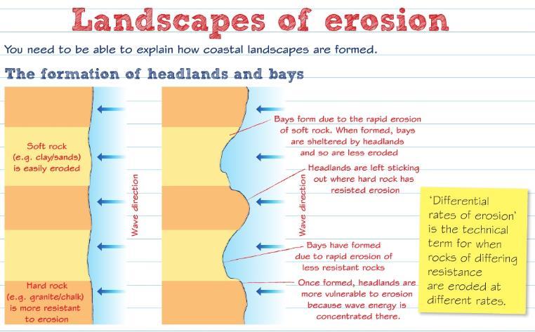
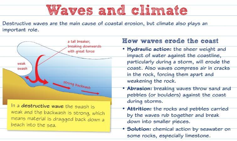
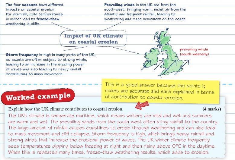
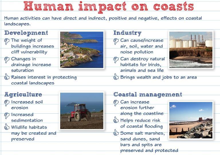
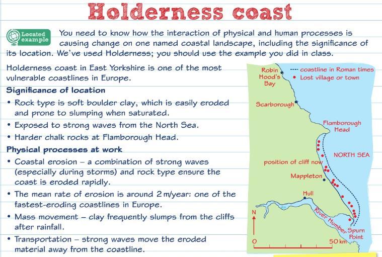
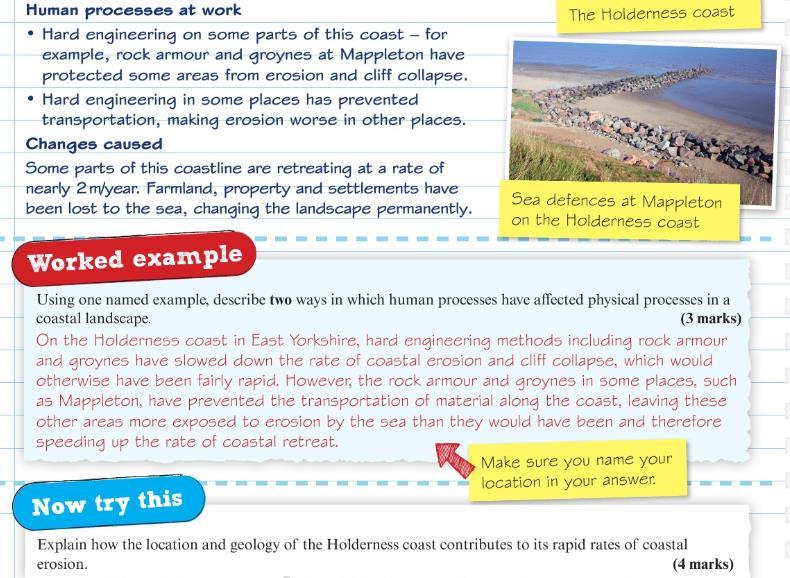
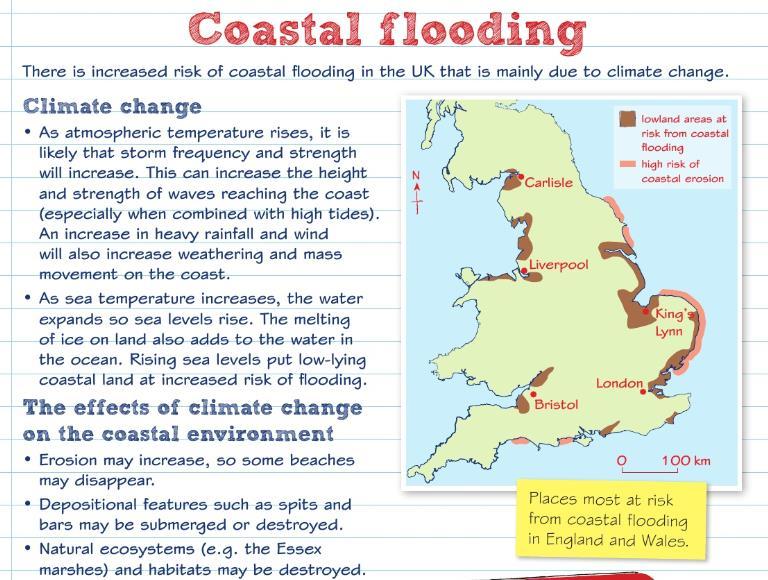
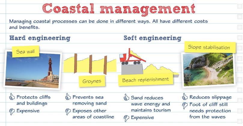
10 UK s Physical Landscape Practice Questions 1. Explain one way glacial processes have contributed to the formation of the UK s physical landscape (2 marks) 2. State the main characteristics of a sedimentary rock (1 mark) 3. Explain how metamorphic rocks form. (2 marks) 4. Explain two ways in which humans have influenced the landscape of the UK. ( 4 marks) 5. Explain how past tectonic processes have shaped the UK landscape (4 marks) 6. Explain one way that climate may be influencing the physical processes in this landscape (2 marks) Coasts Learning Checklist Learning Objective I understand how geological structure and rock type influence erosional landforms in the formation of coastal landscapes of erosion. (Hard/soft rock) (Headlands, Bays, caves, arches, cliffs, stacks) I understand how UK climate, marine and sub-aerial processes are important in coastal landscapes or erosion & rate of erosion. I understand how sediment transportation and deposition processes influence coastal landforms on coastal landscapes of deposition. I understand how human activities have direct or indirect effects on coastal landscapes.
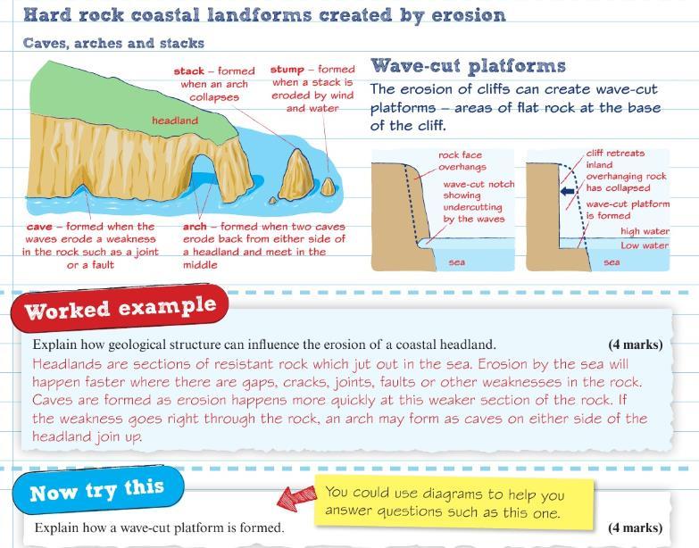
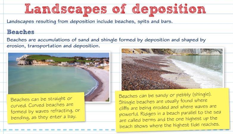
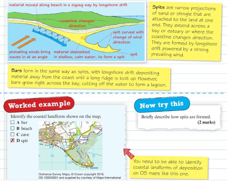
11 I understand how the interaction of physical and human processes is causing change on a named local landscape including the significance of its location. I understand why there are increasing risks from coastal flooding and the threats to people and environment I understand why there are costs and benefits to, and conflicting views about, managing coastal processes by hard/soft/sustain engineering strategies. Coasts Key Words Keywords Abrasion Arch Attrition Backwash Bar Beach Beach profile Cave Concordant Constructive waves Definition the scratching and scraping of a river bed and banks by the stones and sand in a river a curved passage through a headland created when a cave which was eventually broken through by erosion the wearing away of particles of debris by the action of other particles, such as river or beach pebbles the flow of water back to the sea after waves break on a beach an accumulation of sediment that grows across the mouth of a bay, caused by longshore drift an area of sand or pebbles along the shore of a body of water the shape of a beach resulting from how waves break a large hole, either underground or in the side of a hill or cliff, often created when waves force their way into cracks in the cliff face (coasts) follow the ridges and valleys of the land, so the rock strata is parallel to the coastline build beaches by pushing sand and pebbles further up the beach
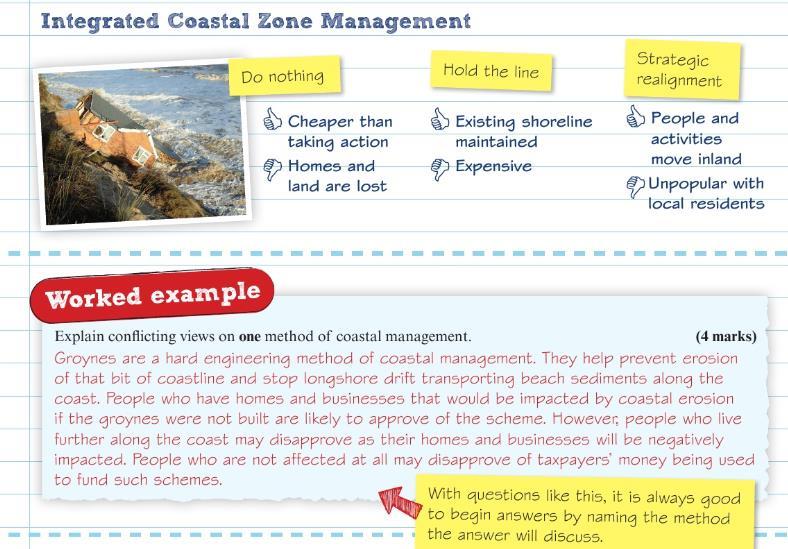
12 Cost-benefit analysis Destructive waves Discordant Fetch Groynes Hard engineering Holistic Hydraulic action Integrated Coastal Zone Management (ICZM) Marine processes Prevailing wind Recurved end Shoreline Management Plan (SMP) Soft engineering Spit Stack looking at all the costs of a project, social and environmental as well as economic, and deciding whether it is worth going ahead waves which erode beaches (coasts) alternate between bands of hard rocks and soft rocks, so the rock *strata is at right angles to the coast the length of water over which the wind has blown, affecting the size and strength of waves wooden or stone structures built at right angles to the coast to trap sediment from longshore drift, allowing a beach to build up building physical structures to deal with natural hazards, such as sea walls to stop waves (coastal management) takes into account all social, economic and environmental costs and benefits. This means looking at the coastline as a whole instead of an individual bay or beach the force of water along the coast, or within a stream or river the holistic management of coasts wave-related processes that contribute to coastal erosion the most frequent direction the wind blows in a certain area the hooked end of a spit an approach which builds on knowledge of the coastal environment and takes account of the wide range of public interest to avoid piecemeal attempts to protect one area at the expense of another involves adapting to natural hazards and working with nature to limit damage a ridge of sand running away from the coast, usually with a curved seaward end a tall column of rock left standing in the sea after wave erosion has separated it from the mainland


13 Storm surge Stump Suspension Swash Terminal groyne syndrome a rapid rise in the level of the sea caused by low pressure and strong winds the part of a stack that has been left after wave erosion has caused the stack to collapse tiny particles of sediment dispersed in water when water rushes up a beach when the last groyne along a coast prevents longshore drift from bringing material to other areas, causing erosion problems further down the coast Coasts Revision Material
14
15
16
17
18
19
20
21
22


23 Coasts Practice Questions
24
 3. Describe two ways in which waves erode a coast (2 marks) 4.")
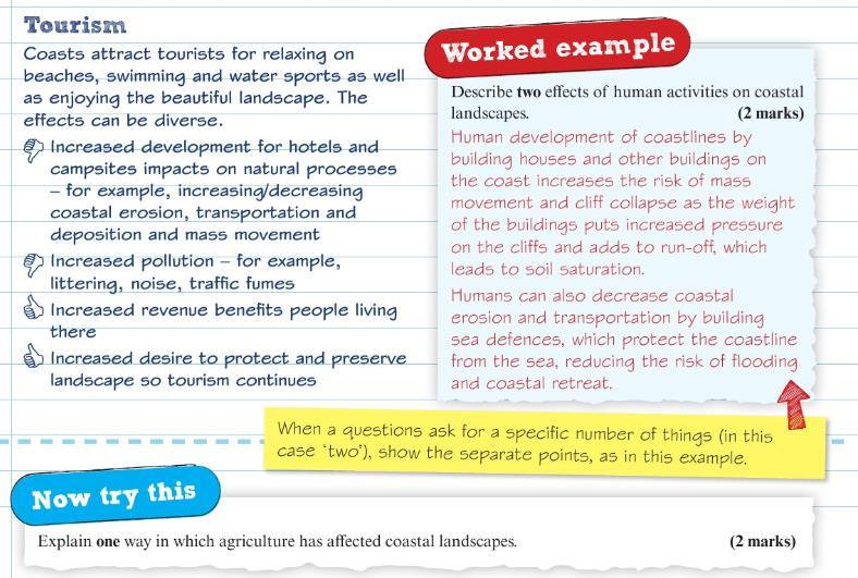
 7. Explain one way in which agriculture has affected coastal landscapes (2 marks) 8.")
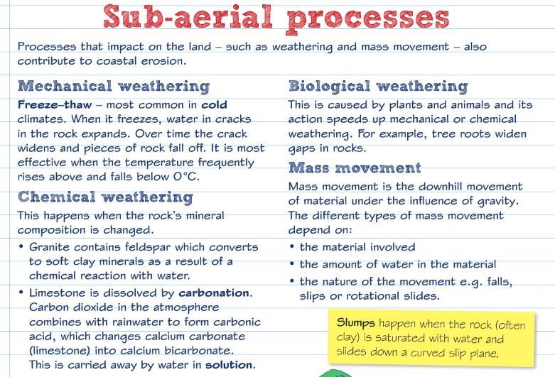
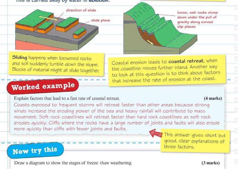
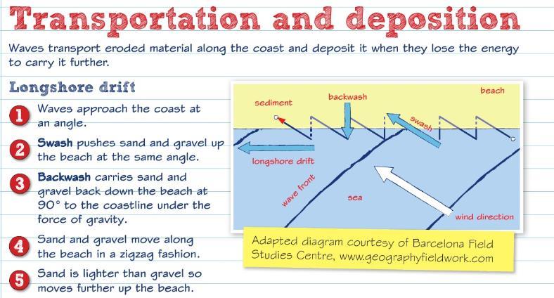
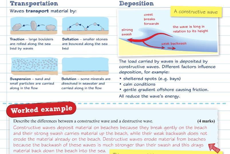
25 1. Identify two landforms that are characteristic of a discordant coast (2 marks) 2. Explain how a wave cut platform is formed (4 marks) 3. Describe two ways in which waves erode a coast (2 marks) 4. Draw a diagram to show the stages of freeze-thaw weathering (3 marks) 5. Explain the process of longshore drift (4 marks) 6. Describe how spits are formed (2 marks) 7. Explain one way in which agriculture has affected coastal landscapes (2 marks) 8. Explain why climate change brings an increased risk of coastal flooding in the UK (4 marks)
26 9. Outline one cost and one benefit of one hard engineering method of coastal management. (4 marks) 10. Define the term concordant coast (1 mark) 11. Describe two characteristics of soft rock cliffs (2 marks) 12. Explain two differences between destructive and constructive waves (2 marks) 13. State two factors that influence the size and type of wave (2 marks) 14. Define the term sub-aerial processes (1 marks) 15. Draw a labelled diagram to explain the process of longshore drift (3 marks) 16. Explain how human activities can affect the coastal landscape (4 marks) 17. For a named example, explain how coastal management processes have changed the coastal landscape (4 marks) 18. Explain why sea-level rise is threatening coastal areas across the UK. (4 marks) 19. Coastal areas are increasingly threatened by rising sea levels. Assess the possible consequences of sea level rise for people living near the coast (8 marks) 20. Explain how groynes can help reduce rates of coastal erosion (2 marks) 21. Describe one advantage of beach nourishment (2 marks) 22. Explain one advantage of using hard defences at the coast (2 marks)
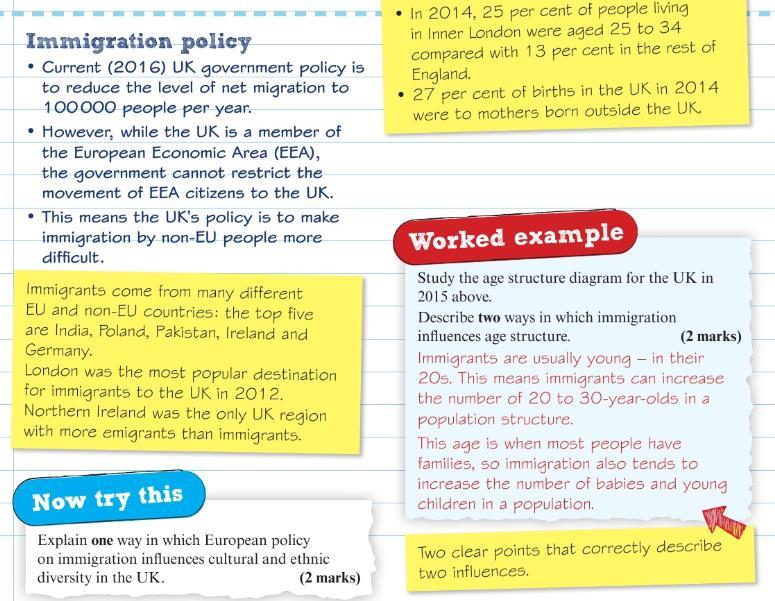
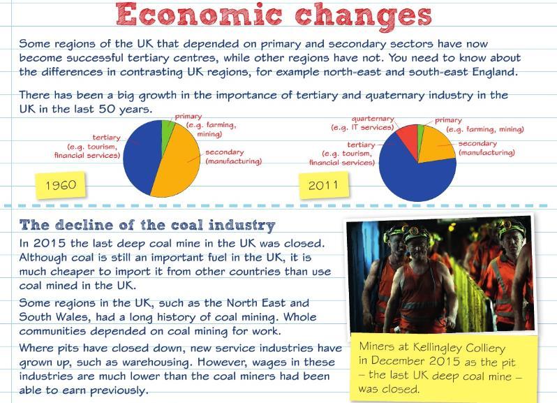
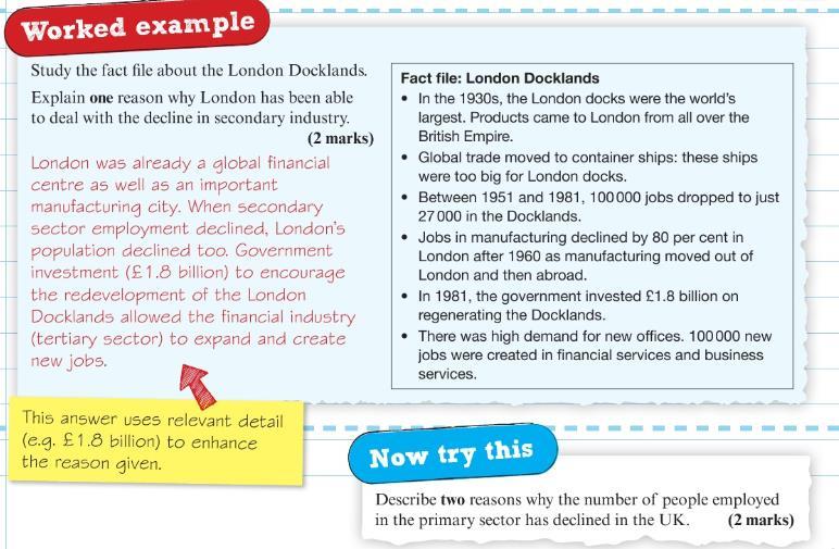
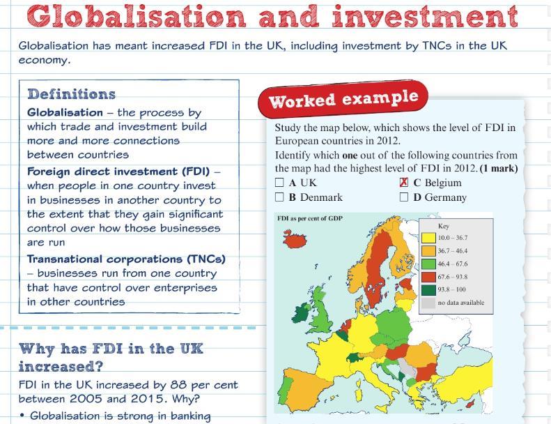
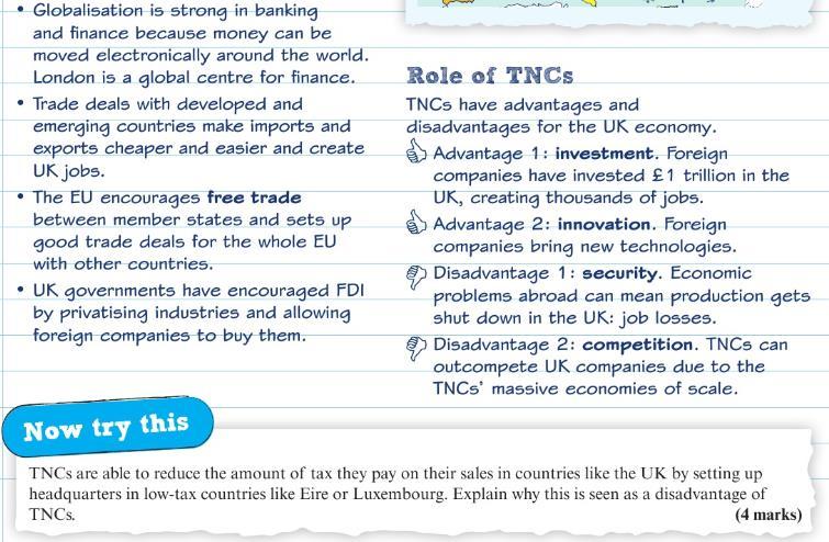
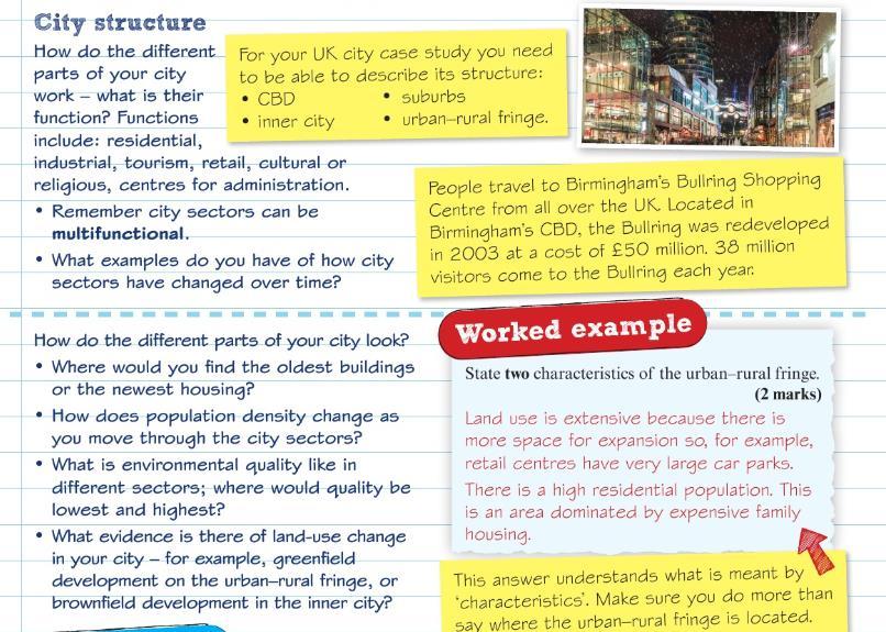
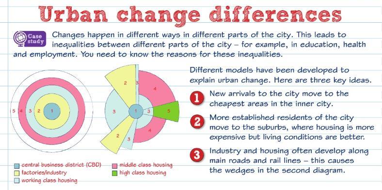
27 UK s Human Landscape Learning Checklist Learning Objective I understand the differences between urban core and rural. I know how the UK and EU government policies have attempted to reduce them. I understand why national and international migration over the past 50 years has altered the population geography of the UK, examining UK and EU immigration policy. I understand the decline in primary and secondary sectors and the rise of tertiary and quaternary sectors in urban and rural areas, altering employment structures in different UK regions. I understand why globalisation, free-trade policies and privatisation has increased foreign direct investment and the role of TNC s in the UK economy. I understand the significance of site, situation and connectivity of the city in a national, regional and global context. I understand the city s structure, inner city, in terms of its functions and variations in building age and density, land-use and environmental quality. I understand the causes of national and international migration that influence growth and character the different parts of the city. I understand the reasons for different levels of inequality, in employment and services, education, health in different parts of the city. I understand how parts of the city have experienced decline, de-centralisation, e-commerce, developments in transport. I understand how parts of the city have experiences economic and population growth. I understand how regeneration and rebranding of the city has positive and negative impacts on people.
28 I understand the strategies aimed at making urban living more sustainable and improving quality of life in the city. UK s Human Landscape Key Words Keyword Accessible Affordable housing Brownfield sites Business parks Conurbations Core regions Counter-urbanisation Decentralisation Deindustrialisation Deprivation Enterprise zones EU grants Footloose Foreign direct investment (FDI) Free trade Definition Easy to get to and from cheaper housing land previously used for industrial purposes that has become vacant areas specifically designed for business offices and small factories a continuous urban or built-up area, formed by merging towns or cities urban areas that drive the economy when people leave towns and cities to live in the countryside shift of shopping activity and employment away from the Central Business District (CBD) decreased activity in manufacturing and closure of industries, leading to unemployment a lack of wealth and services. It usually means low standards of living caused by low income, poor health, and low educational qualifications areas where the UK government offers companies help with start-up costs, reduced taxes on profits, and access to superfast broadband in order to attract them to the area funds to help the poorest regions of the EU whose GDP is below 75% of the EU average companies not tied to location, such as many hightech companies investment by one country into another country the free flow of goods and services, without the restriction of tariffs
29 Gentrification Globalisation Index of multiple deprivation (IMD) Infrastructure Knowledge economy Multiplier effect New economy Northern powerhouse Old economy Primary sector Quality of life Quaternary sector Regional development grants Retail park Rural periphery Rural-urban fringe Secondary sector high-income earners move into run-down areas to be closer to their workplace, often resulting in the rehabilitation and regeneration of the area to conform with middle class lifestyles increased connections between countries a government measure of how deprived areas are based on factors such as employment, housing and education the basic physical and organisational structures and facilities (i.e. buildings) a country needs to operate, such as roads and power supplies an economy based on specialised knowledge and skill when people or businesses move to an area and invest money in housing and services, which in turn creates more jobs and attracts more people economic activities based on knowledge and information, rather than more traditional industries such as manufacturing a major core region of cities (with a similar population to London) that has the potential to drive the economy of northern England an economy based on traditional industries sector of the economy involved with getting raw materials from the natural environment, such as farming, fishing and mining a measure of how wealthy people are, but measured using criteria such as housing, employment and environmental factors, rather than income sector of the economy that is based on specialised knowledge and skill grants and advice to help businesses start up. Most are targeted at peripheral areas, but funds are small a shopping area on the edge of a town or city, usually having several large chain stores areas away from the urban core the area where a town or city meets the countryside sector of the economy involved with manufacturing and assembling

30 Studentification Tertiary sector Trans-national corporation World city communities benefit from local universities which provide employment opportunities and a large student population which can regenerate pubs, shops and buy-to-let properties sector of the economy involved with providing services, such as insurance, teaching and health care companies that operate in more than one country a city that plays a disproportionate role in world affairs and is a centre for finance and trade, e.g. London UK s Human Landscape Revision Material
31
32
33
34
35
36
37
38


39 UK s Human Landscape Practice Questions
40
 2.")
")
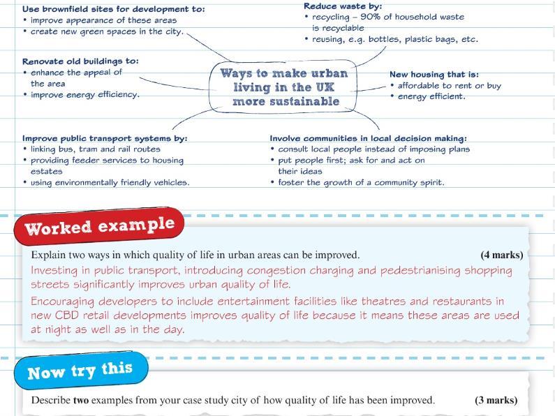
41 1. Describe two ways in which the UK government aims to reduce regional differences within the UK. (2 marks) 2. Describe two reasons why the number of people employed in the primary sector has declined in the UK. (2 marks)
42 3. Describe two examples from your case study city of how quality of life has been improved. (3 marks) 4. Explain how the government s immigration policy has changed the UKs diversity. (4 marks) 5. Explain how globalisation has increased FDI in the UK. (4 marks) 6. Name one factor, other than globalisation, that has contributed to the increase in FDI in the UK. (1 mark) 7. State one positive effect that TNCs have had on the UK economy. (1 mark) 8. Suggest one possible negative effect of over-reliance on TNCs in the UK (2 marks) 9. For a UK city you have studies, explain why some areas of the city have declined. (4 marks) 10. Explain the patterns of migration for a named UK city. (4 marks) Geographical Investigations (Fieldwork) Learning Checklist Learning Objective Investigating coastal change and conflict I understand different questions that can be investigated through fieldwork in the coastal environment. I understand how to use one quantitative fieldwork method to measure coastal management. I understand how to use one qualitative fieldwork method to collect on data on coastal management. I understand how to use two secondary data sources. Investigating urban areas I understand different questions that can be investigated through fieldwork in the urban environments. I understand how to use one qualitative fieldwork method to collect data on perceptions of quality of life.
43 I understand how to use one qualitative fieldwork method to collect on data on environmental quality. I understand how to secondary sources such as census data and one other method. Geographical Investigations (Fieldwork) Key Words Keyword Accuracy Annotated Anomalies Census Environmental quality survey GIS (geographical information system) Primary data Qualitative data Quantitative data Random Range Reliability Definition being correct or exact; having no errors to have a short explanation or comments added to text or drawings unusual data which do not fit the general pattern of results an official count or survey, usually of the population in an area, that also collects information about them, such as age, sex, or occupation measures different characteristics of a place based on numerical judgements with a simple scoring system a computer-based system for capturing, storing, analysing and presenting geographical information that allows you to overlay data first-hand information; fieldwork data that you collect yourself (or as part of a group) techniques that don t involve numbers or counting. They are subjective and involve the judgment of the person collecting data that can be measured numerically where samples are chosen by chance, and every sample has an equal chance of being selected the difference between the highest and lowest values in a set of data the extent to which an investigation produced consistent results

44 Sample size Secondary data SMP (Shoreline Management Plan) Stratified Systematic Trend Validity the number of measurements being taken data that has been collected by someone else an approach which builds on knowledge of the coastal environment and takes account of the wide range of public interest to avoid piecemeal attempts to protect one area at the expense of another collecting a sample made up of different parts working to a plan or set of methods to collect data the general direction of something being logically or factually sound Geographical Investigations (Fieldwork) Revision Material

45
46
47
48
49


50 Geographical Investigations (Fieldwork) Practice Questions
51
 3.")
 4.")
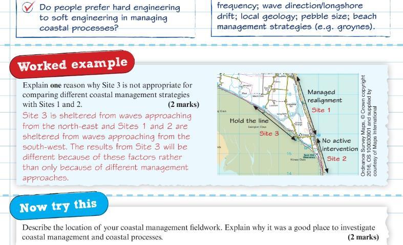
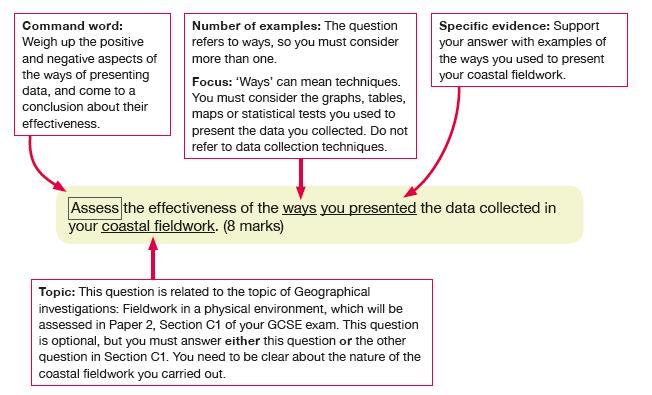
52 1. Explain why it was a good place to investigate coastal management and coastal processes (2 marks) 2. Describe one qualitative fieldwork method you used to investigate the success of a coastal management measure. (2 marks) 3. Evaluate the suitability of your chosen methods of data presentation in helping you make conclusions about the relationship between coastal management and coastal processes (8 marks) 4. Explain how one of your primary data collection techniques was appropriate to the task (3 marks)

 8.")
53 5. Describe two strengths of one of the data presentation techniques that you used. (4 marks) 6. Using an annotated diagram, explain the effectiveness of one coastal management measure you studied. (4 marks) 7. Assess the extent to which your results allowed you to reach a valid conclusion. (8 marks) 8. Suggest one way in which the reliability of your data could be improved (2 marks)
54
 3. Describe one technique you used to present the secondary data you used in your urban study (2 marks) 4.")
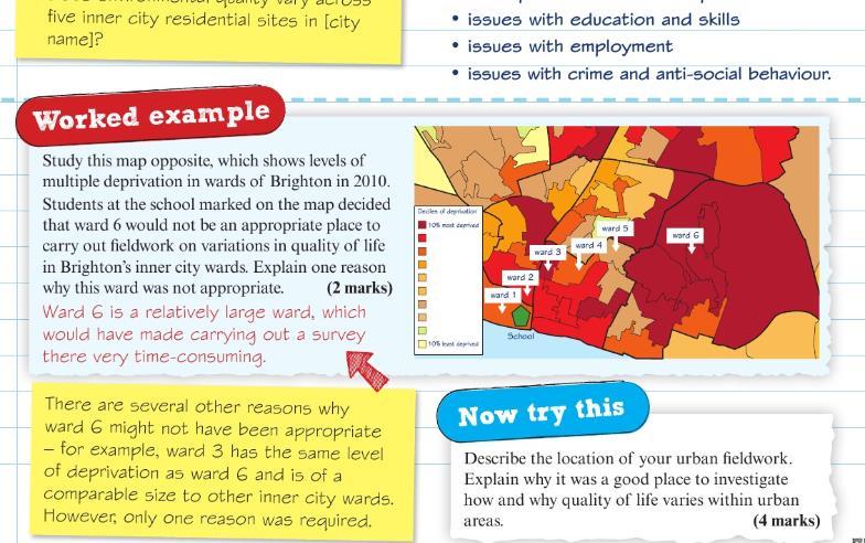
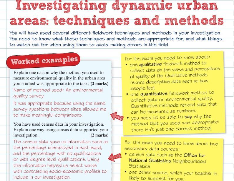
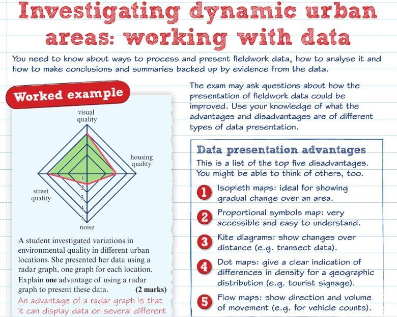
55 1. Describe the location of your urban fieldwork. Explain why it was a good place to investigate how and why quality of life varies within urban areas (4 marks) 2. Explain one weakness of the technique you used to investigate environmental quality (2 marks) 3. Describe one technique you used to present the secondary data you used in your urban study (2 marks) 4. Explain which sampling technique (e.g. random, stratified or systematic) was best suited to your investigation (2 marks) 5. State two ways in which you managed the risks associated with your fieldwork (2 marks) 6. You used census data in your investigation. Explain how this data was useful (2 marks)
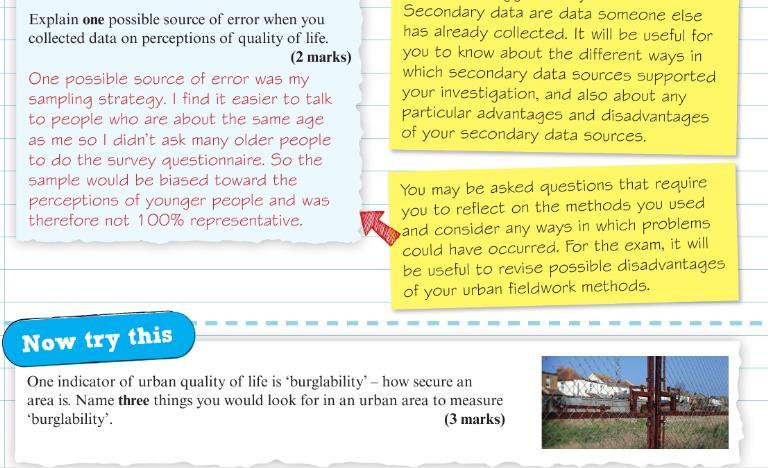
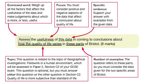
56 7. Other than the data you collected, suggest one source of data that would have helped you to answer your origin question. (2 marks) 8. Explain how you adapted your data presentation techniques to show your results effectively (2 marks) 9. Explain one limitation of your data presentation methods (2 marks) 10. Explain how collecting data on environmental quality allowed you to reach conclusions about why quality of life varies within the area you studied (4 marks) 11. Evaluate the suitability of the site you chose for data collection (8 marks)
Year 11 Geography. Paper 2 UK Geographical Issues. Exam Revision Booklet
 Year 11 Geography Paper 2 UK Geographical Issues Exam Revision Booklet Contents Page Topic Exam Command Words How to structure your answers UK s Physical Landscape Checklist UK s Physical Landscape Key
New GCSE Geography AQA
 Learning Checklist Half Term 1 26 th September 3 rd October 10 th October 17 th October 1.1.1 Tectonic Hazards Plate tectonics theory. Global distribution of earthquakes and volcanic eruptions and their
I CAN DO sheets Southchurch High School
 Rate your confidence in the following topic content and geographical skills by ticking the appropriate column beside each point: Red = Not confident Yellow = Almost there Green = Confident Changing landscapes
Geography Exams. RAG rate The Challenge of Natural Hazards
 Geography Exams You will sit three papers, Paper 1 will last 1 hour 30 minutes and will examine your understanding of The Challenge of Natural Hazards, The Living World and Physical Landscapes in the UK.
Term Knowledge Using and applying Grade Criteria Autumn 1 Assessment window October Natural hazards pose major risks to people and property.
 Assessment Schedule Year 9 2015/6 Term Knowledge Using and applying Grade Criteria Autumn 1 Assessment window October 2015 3.1.1.2 Tectonic Natural hazards pose major risks to people and property. Definition
KS3 Geography Year 8 Core Questions
 Geography Department KS3 Geography Year 8 Name: Class: Teacher: Core Questions These core questions cover key facts for each of the units you will study during year 8. It is an important revision skill
A Level Geography Transition Pack
 Coasts (to go to Mr. Hicks) Independent Research Tasks Complete the tasks below to help you see the bigger picture of the coasts topic. 1. What effect will sea level rise have on coastlines? 2. http://www.theguardian.com/environment/sea-level
Year 10 Geography Curriculum Plan. Geography Edexcel B (9-1) Investigating Geographical Issues (2016)
 Investigating Geographical Issues (2016)") Topic 1: Development Dynamics Paper 1 > Topic 2) Year 10 Geography Curriculum Plan Geography Edexcel B (9-1) Investigating Geographical Issues (2016) Key concept/ Key question Overview of the unit Assessment
Topic 1: Development Dynamics Paper 1 > Topic 2) Year 10 Geography Curriculum Plan Geography Edexcel B (9-1) Investigating Geographical Issues (2016) Key concept/ Key question Overview of the unit Assessment
Topic 4: Changing cities
 Topic 4: Changing cities Overview of urban patterns and processes 4.1 Urbanisation is a global process a. Contrasting trends in urbanisation over the last 50 years in different parts of the world (developed,
2018 Geography Mock Examination
 2018 Geography Mock Examination Your Geography mock examination will test your understanding of Paper 1 (Living with the physical environment) and Section B (Fieldwork) from Paper 2. Attached are the necessary
Physical landscapes River landscapes in the UK
 Physical landscapes River landscapes in the UK The shape of river valleys change s as rivers flow downstream - PROCESSES Erosion Abrasion or corrasion Attrition Hydraulic Action Solution or corrosion Deposition
Global Atmospheric Circulation. Past climate change and natural causes. Global climate change and human activity
 GCSE Geography Edexcel B Revision Checklist Paper 1. Global Geographical Issues Topic 1. Hazardous Earth Key Idea I know/ understand The world s climate system Global Atmospheric Circulation Past climate
Edexcel GCSE Geography A
 Edexcel GCSE Comparing the 2012 AQA GCSE specification with the new 2016 Edexcel specification This document is designed to help you compare the existing 2012 AQA GCSE specification (9030) with the new
PiXL Independence: Geography Answer Booklet KS4. AQA Style, UK Physical Landscapes. Contents: Answers
 PiXL Independence: Geography Answer Booklet KS4 AQA Style, UK Physical Landscapes Contents: Answers 1 I. Multiple Choice Questions 1 Where in the UK would you describe as having large areas of uplands?
Marr College Geography Department. Can-Do Checklist for Higher Geography
 Marr College Geography Department Can-Do Checklist for Higher Geography The Higher Geography exam consists of one paper. It is out of a total of 60 marks. The total time for the paper is 2 hours 15 minutes.
OCR 2008 AS and A level Geography Specification Mapping Guide
 OCR 2008 AS and A level Geography Specification Mapping Guide Contents Introduction Error! Bookmark not defined. Specification map: 2008 OCR AS and A level Geography 3 What's new? 10 Introduction This
AS & A2 Geography for OCR. Tailored Courses. Slapton Ley
 AS & A2 Geography for OCR Tailored Courses Slapton Ley Please visit http://www.field-studies-council.org/outdoorclassroom/geography/aqa/ for alternative A-level AQA programmes OVERVIEW Since the assessment
What is weathering and how does it change Earth s surface? Answer the question using
 7 th Grade Lesson What is weathering and how does it change Earth s surface? Answer the question using the sentence frame. You have 4 minutes. Weathering is. This changes the Earth s surface because. 1
CNCS GCSE. Case Study and Exam Question Revision Booklet
 1 CNCS GCSE Case Study and Exam Question Revision Booklet Note: there is no single way to respond to a 9 mark question attached is guidance only (Grades 7-9 will require judgement and will need to be more
Coasts Key Word Glossary
 Coasts Key Word Glossary Abrasion Also known as corrosion. It is the wearing away of the cliff by sand, fragments of rock and boulders that are being hurled at the cliff by the waves. It causes grinding
Enquiry question: How does the world s climate system function, why does it change and how can this be hazardous for people?
 Content Topic 1: Hazardous Earth Enquiry question: How does the world s climate system function, why does it change and how can this be hazardous for people? 1.1 The atmosphere operates as a global system
Coastal Systems and Landscapes 3 days
 AS Level Geography WJEC Coastal Systems and Landscapes 3 days This course is for Welsh schools. This in-depth course prepares students for the physical fieldwork focusing on the Coastal option, for Section
Subject Area: Geography
 Long Term Planning Overview Key Stage 3 Subject Area: Geography Academic : 08-9 7 Assessment Your Island Home the physical and human geography of the UK and will investigate weather patterns, population
How does erosion happen?
 How does erosion happen? By National Geographic, adapted by Newsela staff on 10.03.17 Word Count 682 Level 830L These rock formations, in Bryce Canyon National Park, Utah, are called hoodoos. Although
Candidate Name Centre Number Candidate Number CHANGING PHYSICAL AND HUMAN LANDSCAPES SAMPLE ASSESSMENT MATERIALS
 GCSE GEOGRAPHY Sample Assessment Materials 5 Candidate Name Centre Number Candidate Number 0 GCSE GEOGRAPHY UNIT 1 CHANGING PHYSICAL AND HUMAN LANDSCAPES SAMPLE ASSESSMENT MATERIALS 1 hour 30 minutes Section
Unit 1 Living with the Physical Environment
 Unit 1 Living with the Physical Environment Topic Example / Case Study Example Tectonic Hazards Chile Nepal Weather Hazards Typhoon Haiyan Somerset Floods Climate Change Ecosystems Tropical Rainforests
Key terms for Theme 1
 Key terms for Theme 1 Terms used in red font are used in the specification. It would be reasonable to expect question setters to use these terms. Other terms and their definitions have been provided by
Edexcel GCSE Geography B
 Comparing the specification with the new 2016 specification This document is designed to help you compare the existing specification 2G01 with the new 2016 specification. The document gives an overview,
Time allowed: 1 hour 30 minutes
 SPECIMEN ASSESSMENT MATERIAL: SET 2 GCSE GEOGRAPHY Paper 1 Living with the physical environment Specimen Materials For this paper you must have: a pencil a ruler. Time allowed: 1 hour 30 minutes Instructions
Edexcel GCSE Geography B: Fieldwork Ideas and Contexts for Tasks
 Edexcel GCSE Geography B: Fieldwork Ideas and Contexts for 2011-2012 Tasks This document provides a list of possible fieldwork and research ideas for the Edexcel B GCSE 2011-2012 Tasks. These are intended
Geography GCSE. Year 9 Term and Topic Unit Content Homework Opportunities
 Geography GCSE Year 9 Term and Topic Unit Content Homework Opportunities Autumn Term 1: Geographical Skills Autumn Term 2: Tectonic Hazards Spring Term 1: Ecosystems Rainforest Students are required to
Subject Overview
 Subject Overview 2018 2019 Department Name: Head of Department: Subject Teachers: Accommodation and Resources: Geography Mrs J Thorne Mr D Jinks Miss A Smith Geography is based in 3 main classrooms. Each
EXTERNAL LAND FORMING PROCESSES
 NAME SCHOOL INDEX NUMBER DATE EXTERNAL LAND FORMING PROCESSES WEATHERING 1 1998 Q 7 (a) (i) What is the difference between weathering and mass wasting (ii) List five processes involved in chemical weathering
Geography - S8 Revision Topics for Trial in November 2013 (Oundle Scholarship)
") Geography - S8 Revision Topics for Trial in November 2013 (Oundle Scholarship) Your Trial in November 2013 will last 1 hour and 30 minutes. You will undertake Sections 1 and 2 during the allocated 1 hour
Geography - S8 Revision Topics for Trial in November 2013 (Oundle Scholarship) Your Trial in November 2013 will last 1 hour and 30 minutes. You will undertake Sections 1 and 2 during the allocated 1 hour
Brazil The country of Brazil is used to consider the different climatic conditions that can occur and why that is. Sport
 SUBJECT : Geography 2014 15 Yr7 What is geography? Students are introduced to the topic of geography and why it is so important to our everyday lives. Within the subject students explore the differences
THEME 1: Landscape and Physical Processes
 What do I need to know for each topic? THEME 1: Landscape and Physical Processes Identify distinctive landscapes as being upland, lowland, coastal and river. Describe how landscapes can be managed e.g.
COASTLINES MARINE EROSION PROCESSES. Read the course booklet.
 MARINE EROSION Read the course booklet. PROCESSES. You will need to know and be able to explain the four methods of coastal erosion and two of weathering The next few slides illustrate these processes.
Erosion and Deposition
 CHAPTER 3 LESSON 2 Erosion and Deposition Landforms Shaped by Water and Wind Key Concepts What are the stages of stream development? How do water erosion and deposition change Earth s surface? How do wind
Read Across America. Listen as I read for facts about Volcanoes. In the Shadow of the Volcano
 Read Across America Listen as I read for facts about Volcanoes. In the Shadow of the Volcano Constructive & Destructive Processes Earth s surface is always changing. Blowing wind and flowing water causes
SUBJECT : Geography Topics: Learning Outcomes:
 SUBJECT : Geography 2016-17 Yr7 What is geography and Britain? Students are introduced to the topic of geography and why it is so important to our everyday lives. Within the subject students explore the
Curriculum Content Summary
 Curriculum Content Summary SUBJECT: Geography Term One Term Two Year 7 Year 8 Year 9 Year 10 Year 11 Year 12 Year 13 Rivers and river floods Glaciers Environmental Issues Controlled Crowded Coasts [opportunity
GCSE. Edexcel GCSE Geography A (1312 1F) Summer Mark Scheme (Results)
 Summer Mark Scheme (Results)") GCSE Edexcel GCSE Geography A (1312 1F) Summer 2006 Mark Scheme (Results) 1. (a) Look at Figure 1a. It shows population growth for Europe and Africa. (i) What was the population of Europe in 1800?...million
GCSE Edexcel GCSE Geography A (1312 1F) Summer 2006 Mark Scheme (Results) 1. (a) Look at Figure 1a. It shows population growth for Europe and Africa. (i) What was the population of Europe in 1800?...million
National 5 Geography Course content checklist
 National 5 Geography Course content checklist This checklist is designed to help you check your understanding of the course content. By ticking the relevant colour you can prioritise revision content prior
Topic 6A: Geographical Investigations fieldwork Investigating coastal landscapes
 Topic 6A: Geographical Investigations fieldwork Investigating coastal landscapes Enquiry question When completing a geographical study, it is important to have an aim. We can do this by asking a task question,
Coastal Landscapes Case Study 3 days
 GCSE Geography OCR B Coastal Landscapes Case Study 3 days In-depth study of a coastal landscape providing a detailed case study, to ensure students are prepared for Paper 1: Our Natural World. Complete
Geol 117 Lecture 18 Beaches & Coastlines. I. Types of Coastlines A. Definition:
 I. Types of Coastlines A. Definition: 1. Shore = narrow zone where ocean meets land (e.g. beach) 2. Coast is a broad area where both ocean and land processes act a. Includes onshore marshes, dunes, sea
UK s Evolving Physical Landscape
 Paper 1 Global Issues Paper 2 UK Issues Paper 3 - Making Geographical Decisions Have you ever wondered 1. How does the world s climate system work and why is climate change becoming such a hazard? 2. What
Coastal Study Delimara Peninsula
 Coastal Study Delimara Peninsula Edward Gilson Fieldwork Report Coastal Study Coastal Processes Delimara Peninsula Location:. Date: Time:. Apparatus:. Weather Conditions: Objectives / Aims: Geography Option
Year 11 Revision Booklet
 Year 11 Revision Booklet Paper 1: Living with the physical environment The challenge of natural hazards Question 1 The living world Question 2 Coastal landscapes in the UK Question 3 River landscapes in
Weathering and Erosion
 Have you ever looked at the land around you and wondered how it was shaped? The geologic features that help define the world are still being shaped by the natural processes of weathering, erosion, and
Year 11 Geography. Paper 1 Global Geographical Issues. Mock Exam Revision Booklet
 Year 11 Geography Paper 1 Global Geographical Issues Mock Exam Revision Booklet Contents Page Topic Exam Command Words How to structure your answers Tectonics Checklist Tectonics Key Words Tectonics Revision
GCSE Revision Booklet
 GCSE Revision Booklet Paper 1: Living with the physical environment Question 1 The challenge of natural hazards The living world Question 2 Coastal landscapes in the UK Question 3 River landscapes in the
Coastal Landscapes Case Study 3 days
 GCSE Geography OCR A Coastal Landscapes Case Study 3 days In-depth study of a coastal landscape providing a detailed case study, to ensure students are prepared for the Paper 1 exam: Living in the UK Today.
Edexcel Geography Advanced Paper 2
 Edexcel Geography Advanced Paper 2 SECTION B: SHAPING PLACES Assessment objectives AO1 Demonstrate knowledge and understanding of places, environments, concepts, processes, interactions and change, at
1 Shoreline Erosion and Deposition
 CHAPTER 12 1 Shoreline Erosion and Deposition SECTION Agents of Erosion and Deposition BEFORE YOU READ After you read this section, you should be able to answer these questions: What is a shoreline? How
Edexcel GCSE Geography B Scheme of Work. Component 2, Topic 5: The UK s evolving human landscape
 Edexcel GCSE Geography B Scheme of Work Component 2, Topic 5: The UK s evolving human landscape Introduction Edexcel GCSE Geography B Investigating Geographical Issues offers an issues-based approach to
WELCOME TO GCSE GEOGRAPHY WHERE WILL IT TAKE US TODAY?
 WELCOME TO GCSE GEOGRAPHY WHERE WILL IT TAKE US TODAY? 1. Re-arrange these two anagrams to provide you with the names of two processes we will be investigating today! 2. Which word has the highest scoring
APPLIED FIELDWORK ENQUIRY SAMPLE ASSESSMENT MATERIALS
 GCSE GEOGRAPHY B Sample Assessment Materials 85 GCSE GEOGRAPHY B COMPONENT 3 APPLIED FIELDWORK ENQUIRY SAMPLE ASSESSMENT MATERIALS 1 hour 30 minutes For examiner s use only SPaG Part A 18 0 Part B 18 0
GRAAD 12 NATIONAL SENIOR CERTIFICATE GRADE 12
 GRAAD 12 NATIONAL SENIOR CERTIFICATE GRADE 12 GEOGRAPHY P1 FEBRUARY/MARCH 2013 MARKS: 300 TIME: 3 hours This question paper consists of 11 pages and a 12-page annexure. Geography/P1 2 DBE/Feb. Mar. 2013
Form 7 Geography. November Exam Revision 2018
 Form 7 Geography November Exam Revision 2018 Location Knowledge You will need to be able to locate both physical and human features on a map of the UK. These are Maps 3 and Maps 4 in your Global Location
KS3 Geography Year 8 Core Knowledge
 Geography Department KS3 Geography Year 8 Name: Class: Teacher: Core Knowledge These core questions cover key facts for each of the units you will study during year 8. It is an important revision skill
The Marine Environment
 The Marine Environment SECTION 16.1 Shoreline Features In your textbook, read about erosional landforms, beaches, estuaries, longshore currents, and rip currents. For each statement below, write or. 1.
What are the different ways rocks can be weathered?
 Romano - 223 What are the different ways rocks can be weathered? Weathering - the breakdown of rocks and minerals at the Earth s surface 1. 2. PHYSICAL WEATHERING Rock is broken into smaller pieces with
Definition of LZ/ card sort activity on parts of the LZ/ discussion on inputs and outputs of the coastal system
 Year 12 Subject Gg Topic Coasts Week 1-6 Coverage / key questions Resources Homework Lesson Learning outcomes Teacher Student Assessment 1 Explain what the littoral zone is Describe the various parts of
Paper Reference. Paper Reference(s) 1312/2F Edexcel GCSE Geography A Foundation Tier. Monday 11 June 2007 Afternoon Time: 1 hour 15 minutes
 1312/2F Edexcel GCSE Geography A Foundation Tier. Monday 11 June 2007 Afternoon Time: 1 hour 15 minutes") Centre No. Paper Reference Surname Initial(s) Candidate No. 1 3 1 2 2 F Signature Paper Reference(s) 1312/2F Edexcel GCSE Geography A Foundation Tier Paper 2F Monday 11 June 2007 Afternoon Time: 1 hour
Centre No. Paper Reference Surname Initial(s) Candidate No. 1 3 1 2 2 F Signature Paper Reference(s) 1312/2F Edexcel GCSE Geography A Foundation Tier Paper 2F Monday 11 June 2007 Afternoon Time: 1 hour
4. The map below shows a meandering stream. Points A, B, C, and D represent locations along the stream bottom.
 1. Sediment is deposited as a river enters a lake because the A) velocity of the river decreases B) force of gravity decreases C) volume of water increases D) slope of the river increases 2. Which diagram
Unit 7.2 W.E.D. & Topography Test
 Name: Score: Unit 7.2 W.E.D. & Topography Test 1. 2. 3. 4. 5. 6. 7. 8. 9. 10. 11. 12. 13. 14. 15. 16. 17. 18. 19. 20. 21. 22. 23. 24. 25. 1. The formation of mountains is due mainly to while the destruction
No. of Periods. Syllabus Topics Specific Objectives Teaching Strategies. rational to live in hazard-prone areas?
 (Syllabus for F.4 Geog. September 2016 - July 2017) -1- SING YIN SECONDARY SCHOOL SYLLABUS FOR GEOGRAPHY -- SEPTEMBER 2016 - JULY 2017 FORM FOUR Textbooks : Senior Secondary Exploring Geography 1 (Second
EDUQAS A LEVEL GEOGRAPHY
 EDUQAS A LEVEL GEOGRAPHY WJ-eC eduqas Specimen Assessment Materials - Component 1 Marked Student Responses The following booklet is compiled from student responses to questions from the Specimen Assessment
Coastal Systems and Landscapes 3 days
 AS Level Geography Eduqas Coastal Systems and Landscapes 3 days Deliver two days of fieldwork within an inspiring physical environment. Prepare AS level students for Paper 1 Section B: Fieldwork Investigation
EROSION AND DEPOSITION
 CHAPTER 8 EROSION AND DEPOSITION SECTION 8 1 Changing Earth s Surface (pages 252-255) This section explains how sediment is carried away and deposited elsewhere to wear down and build up Earth s surface.
Chapter 3 Erosion and Deposition. The Big Question:
 Chapter 3 Erosion and Deposition The Big Question: 1 Design a way to represent and describe the 4 types of mass movement. You may use pictures, diagrams, list, web, chart, etc 2 Chapter 3: Erosion and
Landscapes and People of the UK 4 days
 GCSE Geography OCR B Landscapes and People of the UK 4 days Complete all fieldwork requirements, worth 15% of the qualification. In-depth coverage of fieldwork in two contrasting locations enabling students
Cycles, Systems and Changing Places 5 days
 AS Level Geography AQA Cycles, Systems and Changing Places 5 days Complete the fieldwork requirements for AS level students within physical and human environments. Fieldwork in these locations provides
Introduction The Exam...vii. 1. Maps and Photographs...1
 CONTENTS Introduction The Exam...vii Section 1...vii Section 2...viii 1. Maps and Photographs...1 Grid references on maps...1 Scale and measuring distance...3 Directions on maps...5 Area on maps...6 Height
Year 11: Possible Extended Questions. 1. Using examples explain why it is difficult to predict future population growth.
 Year 11: Possible Extended Questions Population Dynamics 1. Using examples explain why it is difficult to predict future population growth. 2. Explain why the future growth of world population is hard
Weathering of Rocks. Weathering - Breakdown of rocks into pieces (sediment) 2 main types of weathering to rocks
 2 main types of weathering to rocks") Weathering of Rocks Weathering - Breakdown of rocks into pieces (sediment) 2 main types of weathering to rocks Mechanical weathering requires physical forces to break rocks into smaller pieces. Chemical
Weathering of Rocks Weathering - Breakdown of rocks into pieces (sediment) 2 main types of weathering to rocks Mechanical weathering requires physical forces to break rocks into smaller pieces. Chemical
NATIONAL SENIOR CERTIFICATE GRADE 12
 NATIONAL SENIOR CERTIFICATE GRADE 12 GEOGRAPHY P1 FEBRUARY/MARCH 2015 MARKS: 225 TIME: 3 hours This question paper consists of 12 pages and an annexure of 12 pages. *GEOGE1* Geography/P1 2 INSTRUCTIONS
WORK THROUGH THE REVISION CHECKLISTS TO STRUCTURE YOUR REVISION AND HELP YOU TO IDENTIFY AREAS FOR IMPROVEMENT
 GCSE Geography: AQA 8035 http://www.aqa.org.uk/subjects/geography/gcse/geography-8035 Exam advice Work at one mark per minute Learn all key words Look at command words so that you understand what the question
Name. 4. The diagram below shows a soil profile formed in an area of granite bedrock. Four different soil horizons, A, B, C, and D, are shown.
 Name 1. In the cross section of the hill shown below, which rock units are probably most resistant to weathering? 4. The diagram below shows a soil profile formed in an area of granite bedrock. Four different
Geography. Geography A. Curriculum Planner and Skills Mapping Grid GCSE Version 1 October 2012
 Geography GCSE 2012 Geography A Curriculum Planner and Skills Mapping Grid Version 1 October 2012 www.ocr.org.uk/gcse2012 Year 10 Exam work Controlled Assessment Autumn 1 Autumn 2 Spring 1 Spring 2 Summer
Coastal Processes, Patterns and Associated Landforms, and Human Interaction
 Coastal Processes, Patterns and Associated Landforms, and Human Interaction Coastal processes, patterns and associated landforms Coastal processes and the impact of recreational pressures, coastal defence
A Level Geography Cambridge International Content Programme For teaching from September 2016
 A Level Geography Cambridge International Content Programme For teaching from September 2016 is located on the Start Bay coast in South Devon and is surrounded by Slapton Ley National Nature Reserve. The
CHANGING PHYSICAL AND HUMAN LANDSCAPES SAMPLE ASSESSMENT MATERIALS
 GCSE GEOGRAPHY A Sample Assessment Materials 5 GCSE GEOGRAPHY A COMPONENT 1 CHANGING PHYSICAL AND HUMAN LANDSCAPES SAMPLE ASSESSMENT MATERIALS 1 hour 30 minutes Section Question Mark SPaG A B 1 2 Either
Switching to AQA from Edexcel: Draft Geography AS and A-level (teaching from September 2016)
") Switching to AQA from Edexcel: Draft Geography AS and A-level (teaching from September 2016) If you are thinking of switching from OCR to AQA (from September 2016), this resource is an easy reference guide.
Switching to AQA from Edexcel: Draft Geography AS and A-level (teaching from September 2016) If you are thinking of switching from OCR to AQA (from September 2016), this resource is an easy reference guide.
GCSE Geography Paper 1 Practice Paper
 GCSE Geography Paper 1 Practice Paper Student Name: Academy: GCSE Geography Paper 1 Living with the physical environment Assessment Objectives: A01 = 21% is about knowledge A02 = 31% is about understanding
iv vi x Using maps 2 Using images and analysing data 6 Using new technologies in geography 8
 Contents Exam board specification map Introduction Topic checker iv vi x Geographical skills Using maps 2 Using images and analysing data 6 Using new technologies in geography 8 Natural hazards Tectonic
Edexcel GCSE Geography B
 Comparing the 2012 AQA specification with the new 2016 specification This document is designed to help you compare the existing 2012 AQA specification with the new 2016 specification. The document gives
Coimisiún na Scrúduithe Stáit State Examinations Commission
 M. 24 Coimisiún na Scrúduithe Stáit State Examinations Commission LEAVING CERTIFICATE EXAMINATION 2004 GEOGRAPHY HIGHER LEVEL MONDAY, 14 JUNE, AFTERNOON 1.30 TO 4.50 Four questions to be answered, namely
Ensuring Excellence in Post 16 Geography teaching. Elizabeth Bryant Ousedale School
 Ensuring Excellence in Post 16 Geography teaching Elizabeth Bryant Ousedale School Sixth Form: 400 Ousedale School Dual campus academy 2,200 students Progress 8: 0.18 Ebac bucket: 0.16 Geography in the
STAAR 2013 #20; RC3; Readiness 1. Glaciers are masses of ice that move slowly on land. Which of these features was most likely formed by a glacier?
 Earth oot amp #1 5.7 Recognize how landforms such as deltas, canyons, and sand dunes are the result of changes to Earth s surface by wind, water, and ice. STR 2013 #20; R3; Readiness 1. Glaciers are masses
Edexcel 2 Landscape systems, processes and change
 Edexcel 2 Landscape systems, processes and change Area of the Spec Field Site Research areas Primary data collection Secondary data access Statistical analysis High and low Identifying of different Local
Belfairs Academy GEOGRAPHY Fundamentals Map
 YEAR 12 Fundamentals Unit 1 Contemporary Urban Places Urbanisation Urbanisation and its importance in human affairs. Global patterns of urbanisation since 1945. Urbanisation, suburbanisation, counter-urbanisation,
The Coast: Beaches and Shoreline Processes Trujillo & Thurman, Chapter 10
 The Coast: es and Shoreline Processes Trujillo & Thurman, Chapter 10 Oceanography 101 Chapter Objectives Recognize the various landforms characteristic of beaches and coastal regions. Identify seasonal
General Certificate of Secondary Education Higher Tier June 2011
 Centre Number Surname Candidate Number For Examiner s Use Other Names Candidate Signature Examiner s Initials Geography (Specification A) Unit 1 Physical Geography Monday 13 June 2011 For this paper you
Year 11 Geography Revision List
 Plate Tectonics Structure of the earth and major plate boundaries 3 types of plate boundaries (destructive, constructive, conservative) o Be able to draw labelled diagram explaining why earthquakes/volcanoes
GCSE 4232/02 GEOGRAPHY. (Specification A) HIGHER TIER UNIT 2 Options Geography. A.M. FRIDAY, 17 June hour 15 minutes.
 HIGHER TIER UNIT 2 Options Geography. A.M. FRIDAY, 17 June hour 15 minutes.") Candidate Name Centre Number 0 Candidate Number GCSE 4232/02 GEOGRAPHY (Specification A) HIGHER TIER UNIT 2 Options Geography A.M. FRIDAY, 17 June 2011 1 hour 15 minutes Section A Section B For s Use Only
Candidate Name Centre Number 0 Candidate Number GCSE 4232/02 GEOGRAPHY (Specification A) HIGHER TIER UNIT 2 Options Geography A.M. FRIDAY, 17 June 2011 1 hour 15 minutes Section A Section B For s Use Only
Range of Opportunities
 Geograhy Curriculum Cropwell Bishop Primary School Range of Opportunities Year 1 Year 2 Year 3 Year 4 Year 5 Year 6 All Key Stage 1 Key Stage 2 Investigate the countries and capitals of the United Kingdom.
Landscape Systems: Coasts 3 days
 AS Level Geography Edexcel Landscape Systems: Coasts 3 days Deliver two days of fieldwork within an inspiring physical environment covering all the recommended themes in depth. Prepare AS level students
Edexcel A GCSE Geography Course Options For teaching from September 2016
 Edexcel A GCSE Geography Course Options For teaching from September 2016 lies in a secluded valley at the eastern edge of Exmoor National Park. The house is a striking example of a Tudor and Georgian country